Embed Size (px)
Citation preview

November 2000
GPS RECEIVER
GN-79N
SPECIFICATION/PROTOCOL MANUAL
By FURUNO ELECTRIC CO., LTD. System Products Division


TABLE OF CONTENTS
PAGE 1. OUTLINE
1.1 MODEL NAME ・・・・ ・・・・ ・・・・ ・・・・ ・・・・ ・・・・ ・・・・ ・・・・ ・・・・ ・・・・ ・・・・ ・・・・ ・・・・ ・・・・ ・・・・ ・・・・ ・・・・ ・・・・ ・・・・ ・・・・ ・・・・ ・・・・ ・・・・ ・・・・ ・・・・ ・・・・ ・・・・ ・・・・ ・・・・ ・・・・ ・・・・ ・・・・ ・・・・ ・・・・ ・・・・ ・・・・ ・・・・ ・・・・ ・・・・ ・・・・ ・・・・ ・・・・ ・・・・ ・・・・ ・・・・ ・・・・ ・・・・ ・・・・ 1
2. SPECIFICATION 2.1 GENERAL SPECIFICATION ・・・・ ・・・・ ・・・・ ・・・・ ・・・・ ・・・・ ・・・・ ・・・・ ・・・・ ・・・・ ・・・・ ・・・・ ・・・・ ・・・・ ・・・・ ・・・・ ・・・・ ・・・・ ・・・・ ・・・・ ・・・・ ・・・・ ・・・・ ・・・・ ・・・・ ・・・・ ・・・・ ・・・・ ・・・・ ・・・・ ・・・・ ・・・・ ・・・・ ・・・・ ・・・・ ・・・・ ・・・・ 1 2.2 ELECTRICAL SPECIFICATION
2.2.1 ANTENNA CONNECTOR 2.2.1.1 PIN ASSIGNMENT ・・・・ ・・・・ ・・・・ ・・・・ ・・・・ ・・・・ ・・・・ ・・・・ ・・・・ ・・・・ ・・・・ ・・・・ ・・・・ ・・・・ ・・・・ ・・・・ ・・・・ ・・・・ ・・・・ ・・・・ ・・・・ ・・・・ ・・・・ ・・・・ ・・・・ ・・・・ ・・・・ ・・・・ ・・・・ ・・・・ ・・・・ ・・・・ ・・・・ ・・・・ ・・・・ ・・・・ ・・・・ ・・・・ 1 2.2.1.2 ABSOLUTE MAXIMUM RATINGS ・・・・ ・・・・ ・・・・ ・・・・ ・・・・ ・・・・ ・・・・ ・・・・ ・・・・ ・・・・ ・・・・ ・・・・ ・・・・ ・・・・ ・・・・ ・・・・ ・・・・ ・・・・ ・・・・ ・・・・ ・・・・ ・・・・ ・・・・ ・・・・ ・・・・ ・・・・ 1 2.2.1.3 RATINGS ・・・・ ・・・・ ・・・・ ・・・・ ・・・・ ・・・・ ・・・・ ・・・・ ・・・・ ・・・・ ・・・・ ・・・・ ・・・・ ・・・・ ・・・・ ・・・・ ・・・・ ・・・・ ・・・・ ・・・・ ・・・・ ・・・・ ・・・・ ・・・・ ・・・・ ・・・・ ・・・・ ・・・・ ・・・・ ・・・・ ・・・・ ・・・・ ・・・・ ・・・・ ・・・・ ・・・・ ・・・・ ・・・・ ・・・・ ・・・・ ・・・・ ・・・・ ・・・・ ・・・・ ・・・・ ・・・・ 2 2.2.1.4 ANTENNA PREAMP. POWER SUPPLY ・・・・ ・・・・ ・・・・ ・・・・ ・・・・ ・・・・ ・・・・ ・・・・ ・・・・ ・・・・ ・・・・ ・・・・ ・・・・ ・・・・ ・・・・ ・・・・ ・・・・ ・・・・ ・・・・ ・・・・ ・・・・ 2
2.2.1.5 ANTENNA SPECIFICATION ・・・・ ・・・・ ・・・・ ・・・・ ・・・・ ・・・・ ・・・・ ・・・・ ・・・・ ・・・・ ・・・・ ・・・・ ・・・・ ・・・・ ・・・・ ・・・・ ・・・・ ・・・・ ・・・・ ・・・・ ・・・・ ・・・・ ・・・・ ・・・・ ・・・・ ・・・・ ・・・・ ・・・・ ・・・・ ・・・・ 2 2.2.2 POWER/COMMUNICATION CONNECTOR
2.2.2.1 PIN ASSIGNMENT ・・・・ ・・・・ ・・・・ ・・・・ ・・・・ ・・・・ ・・・・ ・・・・ ・・・・ ・・・・ ・・・・ ・・・・ ・・・・ ・・・・ ・・・・ ・・・・ ・・・・ ・・・・ ・・・・ ・・・・ ・・・・ ・・・・ ・・・・ ・・・・ ・・・・ ・・・・ ・・・・ ・・・・ ・・・・ ・・・・ ・・・・ ・・・・ ・・・・ ・・・・ ・・・・ ・・・・ ・・・・ ・・・・ 3 2.2.2.2 ABSOLUTE MAXIMUM RATING ・・・・ ・・・・ ・・・・ ・・・・ ・・・・ ・・・・ ・・・・ ・・・・ ・・・・ ・・・・ ・・・・ ・・・・ ・・・・ ・・・・ ・・・・ ・・・・ ・・・・ ・・・・ ・・・・ ・・・・ ・・・・ ・・・・ ・・・・ ・・・・ ・・・・ ・・・・ ・・・・ 3 2.2.2.3 RATING ・・・・ ・・・・ ・・・・ ・・・・ ・・・・ ・・・・ ・・・・ ・・・・ ・・・・ ・・・・ ・・・・ ・・・・ ・・・・ ・・・・ ・・・・ ・・・・ ・・・・ ・・・・ ・・・・ ・・・・ ・・・・ ・・・・ ・・・・ ・・・・ ・・・・ ・・・・ ・・・・ ・・・・ ・・・・ ・・・・ ・・・・ ・・・・ ・・・・ ・・・・ ・・・・ ・・・・ ・・・・ ・・・・ ・・・・ ・・・・ ・・・・ ・・・・ ・・・・ ・・・・ ・・・・ ・・・・ ・・・・ 4 2.2.2.4 COMMUNICATION SPECIFICATION
2.2.2.4.1 TD, RD SIGNAL LOGIC ・・・・ ・・・・ ・・・・ ・・・・ ・・・・ ・・・・ ・・・・ ・・・・ ・・・・ ・・・・ ・・・・ ・・・・ ・・・・ ・・・・ ・・・・ ・・・・ ・・・・ ・・・・ ・・・・ ・・・・ ・・・・ ・・・・ ・・・・ ・・・・ ・・・・ ・・・・ ・・・・ ・・・・ ・・・・ ・・・・ 5 2.2.2.4.2 1PPS TIMING ・・・・ ・・・・ ・・・・ ・・・・ ・・・・ ・・・・ ・・・・ ・・・・ ・・・・ ・・・・ ・・・・ ・・・・ ・・・・ ・・・・ ・・・・ ・・・・ ・・・・ ・・・・ ・・・・ ・・・・ ・・・・ ・・・・ ・・・・ ・・・・ ・・・・ ・・・・ ・・・・ ・・・・ ・・・・ ・・・・ ・・・・ ・・・・ ・・・・ ・・・・ ・・・・ ・・・・ ・・・・ ・・・・ ・・・・ 5
2.3 ENVIRONMENTAL CONDITIONS ・・・・ ・・・・ ・・・・ ・・・・ ・・・・ ・・・・ ・・・・ ・・・・ ・・・・ ・・・・ ・・・・ ・・・・ ・・・・ ・・・・ ・・・・ ・・・・ ・・・・ ・・・・ ・・・・ ・・・・ ・・・・ ・・・・ ・・・・ ・・・・ ・・・・ ・・・・ ・・・・ ・・・・ ・・・・ ・・・・ ・・・・ ・・・・ ・・・・ 5 3. SOFTWARE SPECIFICATION 3.1 PROGRAM NUMBER ・・・・ ・・・・ ・・・・ ・・・・ ・・・・ ・・・・ ・・・・ ・・・・ ・・・・ ・・・・ ・・・・ ・・・・ ・・・・ ・・・・ ・・・・ ・・・・ ・・・・ ・・・・ ・・・・ ・・・・ ・・・・ ・・・・ ・・・・ ・・・・ ・・・・ ・・・・ ・・・・ ・・・・ ・・・・ ・・・・ ・・・・ ・・・・ ・・・・ ・・・・ ・・・・ ・・・・ ・・・・ ・・・・ ・・・・ ・・・・ ・・・・ ・・・・ ・・・・ 6 3.2 COMMUNICATION SPECIFICATION ・・・・ ・・・・ ・・・・ ・・・・ ・・・・ ・・・・ ・・・・ ・・・・ ・・・・ ・・・・ ・・・・ ・・・・ ・・・・ ・・・・ ・・・・ ・・・・ ・・・・ ・・・・ ・・・・ ・・・・ ・・・・ ・・・・ ・・・・ ・・・・ ・・・・ ・・・・ ・・・・ ・・・・ ・・・・ ・・・・ 6 3.3 ABOUT NMEA-0183 PROTOCOL
3.3.1 APPROVED SENTENCES ・・・・ ・・・・ ・・・・ ・・・・ ・・・・ ・・・・ ・・・・ ・・・・ ・・・・ ・・・・ ・・・・ ・・・・ ・・・・ ・・・・ ・・・・ ・・・・ ・・・・ ・・・・ ・・・・ ・・・・ ・・・・ ・・・・ ・・・・ ・・・・ ・・・・ ・・・・ ・・・・ ・・・・ ・・・・ ・・・・ ・・・・ ・・・・ ・・・・ ・・・・ 7 3.3.2 PROPRIETARY SENTENCES ・・・・ ・・・・ ・・・・ ・・・・ ・・・・ ・・・・ ・・・・ ・・・・ ・・・・ ・・・・ ・・・・ ・・・・ ・・・・ ・・・・ ・・・・ ・・・・ ・・・・ ・・・・ ・・・・ ・・・・ ・・・・ ・・・・ ・・・・ ・・・・ ・・・・ ・・・・ ・・・・ ・・・・ ・・・・ ・・・・ ・・・・ 8 3.4 LIST OF NMEA-0183 SENTENCES ・・・・ ・・・・ ・・・・ ・・・・ ・・・・ ・・・・ ・・・・ ・・・・ ・・・・ ・・・・ ・・・・ ・・・・ ・・・・ ・・・・ ・・・・ ・・・・ ・・・・ ・・・・ ・・・・ ・・・・ ・・・・ ・・・・ ・・・・ ・・・・ ・・・・ ・・・・ ・・・・ ・・・・ ・・・・ ・・・・ ・・・・ 9
3.5 LIST OF PARAMETERS & BACKED-UP DATA ・・・・ ・・・・ ・・・・ ・・・・ ・・・・ ・・・・ ・・・・ ・・・・ ・・・・ ・・・・ ・・・・ ・・・・ ・・・・ ・・・・ ・・・・ ・・・・ ・・・・ ・・・・ ・・・・ ・・・・ 10 3.6 NMEA-0183 INPUT SENTENCES
$XXGLL: Set init ial position ・・・・ ・・・・ ・・・・ ・・・・ ・・・・ ・・・・ ・・・・ ・・・・ ・・・・ ・・・・ ・・・・ ・・・・ ・・・・ ・・・・ ・・・・ ・・・・ ・・・・ ・・・・ ・・・・ ・・・・ ・・・・ ・・・・ ・・・・ ・・・・ ・・・・ ・・・・ ・・・・ ・・・・ ・・・・ ・・・・ ・・・・ ・・・・ ・・・・ ・・・・ ・・・・ 11 $XXGGA: Set init ial position ・・・・ ・・・・ ・・・・ ・・・・ ・・・・ ・・・・ ・・・・ ・・・・ ・・・・ ・・・・ ・・・・ ・・・・ ・・・・ ・・・・ ・・・・ ・・・・ ・・・・ ・・・・ ・・・・ ・・・・ ・・・・ ・・・・ ・・・・ ・・・・ ・・・・ ・・・・ ・・・・ ・・・・ ・・・・ ・・・・ ・・・・ ・・・・ ・・・・ ・・・・ ・・・・ 12 $XXZDA: Set date/t ime ・・・・ ・・・・ ・・・・ ・・・・ ・・・・ ・・・・ ・・・・ ・・・・ ・・・・ ・・・・ ・・・・ ・・・・ ・・・・ ・・・・ ・・・・ ・・・・ ・・・・ ・・・・ ・・・・ ・・・・ ・・・・ ・・・・ ・・・・ ・・・・ ・・・・ ・・・・ ・・・・ ・・・・ ・・・・ ・・・・ ・・・・ ・・・・ ・・・・ ・・・・ ・・・・ ・・・・ ・・・・ ・・・・ ・・・・ 13 $XXRMC: Set init ial position/UTC ・・・・ ・・・・ ・・・・ ・・・・ ・・・・ ・・・・ ・・・・ ・・・・ ・・・・ ・・・・ ・・・・ ・・・・ ・・・・ ・・・・ ・・・・ ・・・・ ・・・・ ・・・・ ・・・・ ・・・・ ・・・・ ・・・・ ・・・・ ・・・・ ・・・・ ・・・・ ・・・・ ・・・・ ・・・・ ・・・・ 14 $PFEC,GPclr: Restart ・・・・ ・・・・ ・・・・ ・・・・ ・・・・ ・・・・ ・・・・ ・・・・ ・・・・ ・・・・ ・・・・ ・・・・ ・・・・ ・・・・ ・・・・ ・・・・ ・・・・ ・・・・ ・・・・ ・・・・ ・・・・ ・・・・ ・・・・ ・・・・ ・・・・ ・・・・ ・・・・ ・・・・ ・・・・ ・・・・ ・・・・ ・・・・ ・・・・ ・・・・ ・・・・ ・・・・ ・・・・ ・・・・ ・・・・ ・・・・ 15 $PFEC,GPset: Setup receiver parameters ・・・・ ・・・・ ・・・・ ・・・・ ・・・・ ・・・・ ・・・・ ・・・・ ・・・・ ・・・・ ・・・・ ・・・・ ・・・・ ・・・・ ・・・・ ・・・・ ・・・・ ・・・・ ・・・・ ・・・・ ・・・・ ・・・・ 16 $PFEC,GPsrq: Get receiver parameters ・・・・ ・・・・ ・・・・ ・・・・ ・・・・ ・・・・ ・・・・ ・・・・ ・・・・ ・・・・ ・・・・ ・・・・ ・・・・ ・・・・ ・・・・ ・・・・ ・・・・ ・・・・ ・・・・ ・・・・ ・・・・ ・・・・ ・・・・ ・・・・ 18 $PFEC,GPint: Request output / Set log output intervals ・・・・ ・・・・ ・・・・ ・・・・ ・・・・ ・・・・ ・・・・ ・・・・ ・・・・ 19 $PFEC,GPirq: Get log sentence output intervals ・・・・ ・・・・ ・・・・ ・・・・ ・・・・ ・・・・ ・・・・ ・・・・ ・・・・ ・・・・ ・・・・ ・・・・ ・・・・ ・・・・ ・・・・ ・・・・ 20 $PFEC,GPdif: Set DGPS parameter ・・・・ ・・・・ ・・・・ ・・・・ ・・・・ ・・・・ ・・・・ ・・・・ ・・・・ ・・・・ ・・・・ ・・・・ ・・・・ ・・・・ ・・・・ ・・・・ ・・・・ ・・・・ ・・・・ ・・・・ ・・・・ ・・・・ ・・・・ ・・・・ ・・・・ ・・・・ ・・・・ ・・・・ 21 $PFEC,GPdrq: Get DGPS parameter ・・・・ ・・・・ ・・・・ ・・・・ ・・・・ ・・・・ ・・・・ ・・・・ ・・・・ ・・・・ ・・・・ ・・・・ ・・・・ ・・・・ ・・・・ ・・・・ ・・・・ ・・・・ ・・・・ ・・・・ ・・・・ ・・・・ ・・・・ ・・・・ ・・・・ ・・・・ ・・・・ 22

3.7 NMEA-0183 OUTPUT SENTENCES $GPDTM: Datum/Set DGPS parameter ・・・・ ・・・・ ・・・・ ・・・・ ・・・・ ・・・・ ・・・・ ・・・・ ・・・・ ・・・・ ・・・・ ・・・・ ・・・・ ・・・・ ・・・・ ・・・・ ・・・・ ・・・・ ・・・・ ・・・・ ・・・・ ・・・・ ・・・・ ・・・・ ・・・・ ・・・・ 23 $GPGGA: Posit ion, alt i tude, UTC, etc. ・・・・ ・・・・ ・・・・ ・・・・ ・・・・ ・・・・ ・・・・ ・・・・ ・・・・ ・・・・ ・・・・ ・・・・ ・・・・ ・・・・ ・・・・ ・・・・ ・・・・ ・・・・ ・・・・ ・・・・ ・・・・ ・・・・ ・・・・ ・・・・ ・・・・ 24 $GPZDA: Date/Time ・・・・ ・・・・ ・・・・ ・・・・ ・・・・ ・・・・ ・・・・ ・・・・ ・・・・ ・・・・ ・・・・ ・・・・ ・・・・ ・・・・ ・・・・ ・・・・ ・・・・ ・・・・ ・・・・ ・・・・ ・・・・ ・・・・ ・・・・ ・・・・ ・・・・ ・・・・ ・・・・ ・・・・ ・・・・ ・・・・ ・・・・ ・・・・ ・・・・ ・・・・ ・・・・ ・・・・ ・・・・ ・・・・ ・・・・ ・・・・ ・・・・ 26
$GPGLL: Posit ion, UTC, etc. ・・・・ ・・・・ ・・・・ ・・・・ ・・・・ ・・・・ ・・・・ ・・・・ ・・・・ ・・・・ ・・・・ ・・・・ ・・・・ ・・・・ ・・・・ ・・・・ ・・・・ ・・・・ ・・・・ ・・・・ ・・・・ ・・・・ ・・・・ ・・・・ ・・・・ ・・・・ ・・・・ ・・・・ ・・・・ ・・・・ ・・・・ ・・・・ ・・・・ 27 $GPGSA: Posit ioning status ・・・・ ・・・・ ・・・・ ・・・・ ・・・・ ・・・・ ・・・・ ・・・・ ・・・・ ・・・・ ・・・・ ・・・・ ・・・・ ・・・・ ・・・・ ・・・・ ・・・・ ・・・・ ・・・・ ・・・・ ・・・・ ・・・・ ・・・・ ・・・・ ・・・・ ・・・・ ・・・・ ・・・・ ・・・・ ・・・・ ・・・・ ・・・・ ・・・・ ・・・・ 28 $GPGSV: Satell ite details ・・・・ ・・・・ ・・・・ ・・・・ ・・・・ ・・・・ ・・・・ ・・・・ ・・・・ ・・・・ ・・・・ ・・・・ ・・・・ ・・・・ ・・・・ ・・・・ ・・・・ ・・・・ ・・・・ ・・・・ ・・・・ ・・・・ ・・・・ ・・・・ ・・・・ ・・・・ ・・・・ ・・・・ ・・・・ ・・・・ ・・・・ ・・・・ ・・・・ ・・・・ ・・・・ ・・・・ 29 $GPVTG: Course and speed ・・・・ ・・・・ ・・・・ ・・・・ ・・・・ ・・・・ ・・・・ ・・・・ ・・・・ ・・・・ ・・・・ ・・・・ ・・・・ ・・・・ ・・・・ ・・・・ ・・・・ ・・・・ ・・・・ ・・・・ ・・・・ ・・・・ ・・・・ ・・・・ ・・・・ ・・・・ ・・・・ ・・・・ ・・・・ ・・・・ ・・・・ ・・・・ ・・・・ ・・・・ 30 $GPRMC: UTC, posit ion, course, speed, etc. ・・・・ ・・・・ ・・・・ ・・・・ ・・・・ ・・・・ ・・・・ ・・・・ ・・・・ ・・・・ ・・・・ ・・・・ ・・・・ ・・・・ ・・・・ ・・・・ ・・・・ ・・・・ ・・・・ 31 $PFEC,GPanc: Almanac date and satell i te’s health condition ・・・・ ・・・・ ・・・・ ・・・・ 33 $PFEC,GPacc: SV(satell ite) Accuracy ・・・・ ・・・・ ・・・・ ・・・・ ・・・・ ・・・・ ・・・・ ・・・・ ・・・・ ・・・・ ・・・・ ・・・・ ・・・・ ・・・・ ・・・・ ・・・・ ・・・・ ・・・・ ・・・・ ・・・・ ・・・・ ・・・・ ・・・・ ・・・・ ・・・・ ・・・・ 34 $PFEC,GPast: Posit ion, alt itude, speed, course, local t ime etc. ・・・・ ・・・・ 35 $PFEC,GPtst: Self-test results ・・・・ ・・・・ ・・・・ ・・・・ ・・・・ ・・・・ ・・・・ ・・・・ ・・・・ ・・・・ ・・・・ ・・・・ ・・・・ ・・・・ ・・・・ ・・・・ ・・・・ ・・・・ ・・・・ ・・・・ ・・・・ ・・・・ ・・・・ ・・・・ ・・・・ ・・・・ ・・・・ ・・・・ ・・・・ ・・・・ ・・・・ ・・・・ 37 $PFEC,GPssd: Receiver parameters set by $PFEC,GPset ・・・・ ・・・・ ・・・・ ・・・・ ・・・・ ・・・・ ・・・・ ・・・・ 38 $PFEC,GPisd: Log output intervals set by $PFEC,GPint ・・・・ ・・・・ ・・・・ ・・・・ ・・・・ ・・・・ ・・・・ ・・・・ ・・・・ 39 $PFEC,GPdsd: DGPS parameters set by $PFEC,Gpdif ・・・・ ・・・・ ・・・・ ・・・・ ・・・・ ・・・・ ・・・・ ・・・・ ・・・・ ・・・・ ・・・・ ・・・・ 40
$PFEC,GPdie: Receiver status ・・・・ ・・・・ ・・・・ ・・・・ ・・・・ ・・・・ ・・・・ ・・・・ ・・・・ ・・・・ ・・・・ ・・・・ ・・・・ ・・・・ ・・・・ ・・・・ ・・・・ ・・・・ ・・・・ ・・・・ ・・・・ ・・・・ ・・・・ ・・・・ ・・・・ ・・・・ ・・・・ ・・・・ ・・・・ ・・・・ ・・・・ ・・・・ ・・・・ 41 $PFEC,Gpspe,ANCOUT: Down-load almanac ・・・・ ・・・・ ・・・・ ・・・・ ・・・・ ・・・・ ・・・・ ・・・・ ・・・・ ・・・・ ・・・・ ・・・・ ・・・・ ・・・・ ・・・・ ・・・・ ・・・・ ・・・・ ・・・・ ・・・・ ・・・・ 42 $PFEC,GPspe,ANCINP: Up-load almanac ・・・・ ・・・・ ・・・・ ・・・・ ・・・・ ・・・・ ・・・・ ・・・・ ・・・・ ・・・・ ・・・・ ・・・・ ・・・・ ・・・・ ・・・・ ・・・・ ・・・・ ・・・・ ・・・・ ・・・・ ・・・・ ・・・・ ・・・・ ・・・・ 43
5. GEODETIC ID・・・・ ・・・・ ・・・・ ・・・・ ・・・・ ・・・・ ・・・・ ・・・・ ・・・・ ・・・・ ・・・・ ・・・・ ・・・・ ・・・・ ・・・・ ・・・・ ・・・・ ・・・・ ・・・・ ・・・・ ・・・・ ・・・・ ・・・・ ・・・・ ・・・・ ・・・・ ・・・・ ・・・・ ・・・・ ・・・・ ・・・・ ・・・・ ・・・・ ・・・・ ・・・・ ・・・・ ・・・・ ・・・・ ・・・・ ・・・・ ・・・・ ・・・・ ・・・・ ・・・・ ・・・・ ・・・・ ・・・・ ・・・・ ・・・・ ・・・・ ・・・・ 44
-1-
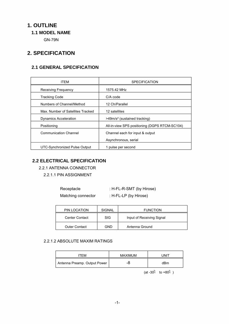
1. OUTLINE 1.1 MODEL NAME
GN-79N
2. SPECIFICATION
2.1 GENERAL SPECIFICATION
ITEM SPECIFICATION
Receiving Frequency 1575.42 MHz
Tracking Code C/A code
Numbers of Channel/Method 12 Ch/Parallel
Max. Number of Satellites Tracked 12 satellites
Dynamics Acceleration >49m/s² (sustained tracking)
Positioning All-in-view SPS positioning (DGPS RTCM-SC104)
Communication Channel Channel each for input & output
Asynchronous, serial
UTC-Synchronized Pulse Output 1 pulse per second
2.2 ELECTRICAL SPECIFICATION
2.2.1 ANTENNA CONNECTOR
2.2.1.1 PIN ASSIGNMENT
Receptacle : H-FL-R-SMT (by Hirose)
Matching connector : H-FL-LP (by Hirose)
PIN LOCATION SIGNAL FUNCTION
Center Contact SIG Input of Receiving Signal
Outer Contact GND Antenna Ground
2.2.1.2 ABSOLUTE MAXIM RATINGS
ITEM MAXIMUM UNIT
Antenna Preamp. Output Power -8 dBm
(at -30 to +80)
-2-
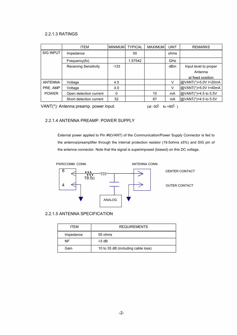
2.2.1.3 RATINGS
ITEM MINIMUM TYPICAL MAXIMUM UNIT REMARKS
SIG INPUT Impedance 50 ohms
Frequency(fo) 1.57542 GHz Receiving Sensitivity -133 dBm Input level to proper
Antenna at fixed position
Voltage 4.5 V @VANT(*)=5.0V I=20mA Voltage 4.0 V @VANT(*)=5.0V I=40mA Open detection current 0 10 mA @VANT(*)=4.5 to 5.5V
ANTENNA PRE. AMP POWER
Short detection current 52 87 mA @VANT(*)=4.5 to 5.5V
VANT(*): Antenna preamp. power input. (at -30 to +80)
2.2.1.4 ANTENNA PREAMP. POWER SUPPLY
External power applied to Pin #6(VANT) of the Communication/Power Supply Connector is fed to
the antenna/preamplifier through the internal protection resistor (19.5ohms ±5%) and SIG pin of
the antenna connector. Note that the signal is superimposed (biased) on this DC voltage.
PWR/COMM. CONN. ANTENNA CONN.
6 CENTER CONTACT
19.5Ω
4 OUTER CONTACT
ANALOG
2.2.1.5 ANTENNA SPECIFICATION
ITEM REQUIREMENTS
Impedance 50 ohms
NF <3 dB
Gain 10 to 35 dB (including cable loss)

-3-
2.2.2 POWER/COMMUNICATION CONNECTOR
2.2.2.1 PIN ASSIGNMENT
* Receptacle type 53254-0710 (By Molex Japan Co., LTD.)
* Matching connector type 51065-0700 (By Molex Japan Co., LTD.)
PIN NO. SIGNAL FUNCTION 1 1PPS 1 pulse/sec output 2 TD Data output
3 RD Data input
4 GND Ground
5 VBAK Back-up power supply (*)
6 VANT Antenna pre. amp. power supply
7 VCC Power Supply
(*) No internal backup power supply is available.
2.2.2.2 ABSOLUTE MAXIMAM RATING
ITEM MAXIMUM RATING UNIT Condition
RD input voltage -0.3 to +6.6 & -0.3 to VCC+3.0
V
TD/1PPS output voltage -0.3 to +6.6 & -0.3 to VCC+3.0
V
TD output current (*) ±20 mA VCC input voltage -0.3 to +6.5 V VBAK input voltage -0.3 to +6.5 V VANT input voltage -0.3 to +6.5 &
-0.3 to +VCCx2 V Antenna current<220mA
(at -30°C to +80°C)
(*) The current into the GN-79N should be (+).

-4-
2.2.2.3 RATING
(at -30°C to +80°C)
ITEM MIN. TYPICAL MAX. UNIT REMARKS
TD/1PPS*2 H VOLTAGE VCC-1.0 VCC V @-150μA *1
(OUTPUT) L VOLTAGE 0 0.4 V @4.0mA
VOLTAGE 2.6 VCC V
RD*3
H
CURRENT*1 ±0.1 mA @VCC
(INPUT) L VOLTAGE 0 0.8 V
CURRENT*1 -1.2 mA @0.8V
H VOLTAGE 3.8 V @-4.0mA*1
L VOLTAGE 0.5 V @4.0mA
1PPS
(OUTPUT)
Duty 50 %
VCC VOLTAGE 4.5 5.0 5.5 V
CURRENT*1 79 mA @3.3V, 25°C
VBAK VOLTAGE 2.5 5.5 V
CURRENT*1 3.0 10 μA @VBAK=3.0V VCC=0V
25°C,
VANT VOLTAGE 4.5 5 5.5 V
*1The current into the GN-79N should be (+).
VCC
*2Pulled up to VCC through 4.7KΩ (±5%) Registe
TD output Equivalent Circuit
*3Pulled up to VCC through 4.7KΩ( ±5%)Register.
VCC
RD Input Equivalent Circuit
TD
4.7 KΩ
r. 4.7 KΩ
RD

-5-
2.2.2.4 COMMUNICATION SPECIFICATION
2.2.2.4.1 TD, RD SIGNAL LOGIC
CMOS HIGH
CMOS LOW
STOP BIT
LSB MSB
START BIT
2.2.2.4.2 1 PPS TIMING
1 PPS is output synchronized with UTC during when positioning is obtained.
Rising edge of 1 pps is synchronized with UTC one second.
2.3ENVIRONMENTAL CONDITIONS
ITEM UNIT REMARKS
OPERATING TEMPERATURE -30 to +80 °C
BACK-UP TEMPERATURE -30 to +80 °C
STORAGE TEMPERATURE -40 to +85 °C
90 @ +60°C No condensation HUMIDITY 95
%RH @ +45°C No condensation
VIBRATION 43.1 m/s² @ 10 to 200 Hz
time = t-1 1PPS
time = t 1PPS
time = t+1 1PPS
time = t serial data
time = t +1 serial data

-6-
3. SOFTWARE SPECIFICATION 3.1 PROGRAM NUMBER
Program number48502180**(** represents version number)
3.2 COMMUNICATION SPECIFICATION System: Ful l Duplex Asynchronous Speed: 4800 BPS Start Bit : 1 bi t Data Length: 8 bi ts (MSB=0) Stop Bit : 1 bi t Par i ty Bit : None
Start Bit B0 B1 B2 B3 B4 B5 B6 B7 Stop Bit Flow Control : None Signal Lines used: TD1 and RD1 only (TD2 and RD2 not used) Data Output Interval: 0 to 2 seconds Character Codes used NMEA-0183 Sentences: ASCII (HEX 0D,0A,20 to 7E) Dif ferent ial GPS Data: Binary (“6-of -8” format) (B7=0, B6=1, Only B5 to B0 are used.)
Electr ical specif icat ion Similar to RS-232C
Protocol:
NMEA-0183 Sentences: NMEA-0183 Ver 2.30 dated March 1, 1998
(Approved/propr ietary sentences) ( Input/Output)
Dif ferent ial GPS Data RTCM SC-104 Ver 2.1 dated January 3, 1994 ( Input only)
NOTE: NMEA-0183 sentence and dif ferent ial GPS data inputs may coexist because
the GN79 can dist inguish them automatical ly.
-7-
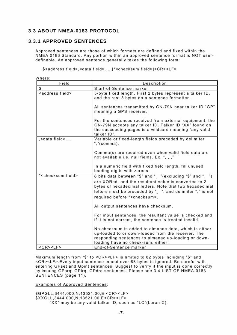
3.3 ABOUT NMEA-0183 PROTOCOL 3.3.1 APPROVED SENTENCES
Approved sentences are those of which formats are def ined and f ixed within the NMEA 0183 Standard. Any port ion within an approved sentence format is NOT user-def inable. An approved sentence general ly takes the fol lowing form:
$<address f ield>,<data f ield>.. . . . [*<checksum f ield>]<CR><LF>
W here:
Field Descr ipt ion $ Start-of -Sentence marker <address f ield> 5-byte f ixed length. First 2 bytes represent a talker ID,
and the rest 3 bytes do a sentence formatter. Al l sentences transmitted by GN-79N bear talker ID “GP” meaning a GPS receiver. For the sentences received f rom external equipment, the GN-79N accepts any talker ID. Talker ID “XX” found on the succeeding pages is a wi ldcard meaning “any val id talker ID”.
,<data f ield>.. . . Variable or f ixed-length f ields preceded by del im iter “ , ” (comma). Comma(s) are required even when val id f ield data are not avai lable i .e. nul l f ie lds. Ex. “ , , , , , ” In a numeric f ield with f ixed f ield length, f i l l unused leading digi ts with zeroes.
*<checksum f ield> 8 bi ts data between “$” and “* ” (excluding “$” and “* ” ) are XORed, and the resultant value is converted to 2 bytes of hexadecimal let ters. Note that two hexadecimal let ters must be preceded by “* ” , and del im iter “ ,” is not required before *<checksum>. Al l output sentences have checksum. For input sentences, the resultant value is checked and i f i t is not correct, the sentence is treated inval id. No checksum is added to almanac data, which is ei ther up- loaded to or down-loaded f rom the receiver. The responding sentences to almanac up- loading or down-loading have no check-sum, ei ther.
<CR><LF> End-of-Sentence marker
Maximum length f rom “$” to <CR><LF> is l im ited to 82 bytes including “$” and <CR><LF>.Every input sentence in and over 83 bytes is ignored. Be careful with enter ing GPset and Gpint sentences. Suggest to ver i fy i f the input is done correct ly by issuing GPsrq, GPirq, GPdrq sentences. Please see 3.4 LIST OF NMEA-0183 SENTENCES (page 11). Examples of Approved Sentences: $GPGLL,3444.000,N,13521.00,E <CR><LF> $XXGLL,3444.000,N,13521.00,E<CR><LF>
“XX” may be any val id talker ID, such as “LC”(Loran C).

-8-
3.3.2 PROPRIETARY SENTENCES
The NMEA-0183 standard al lows nav-aid makers to send propr ietary sentences i f the minimum rules def ined by the NMEA are obeyed. Propr ietary sentences must take the fol lowing form, but i t is f ree to makers what k ind of f ie lds are included and in what order they are transmitted out.
$P<maker ID>,<data f ield>.. . .<* check sum f ield><CR><LF>
W here:
Field Descr ipt ion
$ Start-of -Sentence marker P Propr ietary sentence ident i f ier <maker ID> 3-byte f ixed length.
GN-79N’s maker ID is “FEC” meaning Furuno Electr ic Company.
,<data f ield>.. . . Variable or f ixed-length f ields preceded by del im iter “ , ” (comma). (Layout is maker-def inable.)
<check sum f ield> 8 bi ts data between “$” and “* ” (excluding “$” and “* ” ) are XORed, and the resultant value is converted to 2 bytes of hexadecimal let ters. Note that two hexadecimal let ters must be preceded by “* ” , and del im iter “ ,” is not required before *<checksum>. Al l output sentences have checksum. For input sentences, the resultant value is checked and i f i t is not correct, the sentence is treated inval id. No checksum is added to almanac data, which is ei ther up- loaded to or down-loaded f rom the receiver. The responding sentences to almanac up- loading or down-loading have no check-sum, ei ther.
<CR><LF> End-of-Sentence marker

-9-
3.4 LIST OF NMEA-0183 SENTENCES The fol lowing NMEA-0183 sentences are supported by GN-79N. INPUT SENTENCE OUTPUT SENTENCE
GPDTM Datum HIGH XXGGA Set in i t ia l pos i t ion GPGGA Posi t ion, t ime etc . OO
XXZDA Set t ime, e tc . GPZDA Time etc . OO XXGLL Set in i t ia l pos i t ion GPGLL Posi t ion, t ime, e tc . O GPGSA Status, DOP O GPGSV Sate l l i te deta i ls OO GPVTG Speed, Course. OO XXRMC Set in i t ia l pos i t ion,
t ime GPRMC Posi t ion, t ime, speed,
course O
GPal t No. o f sate l l i tes expected in coming 24 hours
O
GPanc Date of exis t ing a lmanac O GPacc SV accuracy O GPas t GPS f ix (pos i t ion, loca l
t ime) O
GPts t Sel f test resul t O GPsrq Send GPS receiver
parameters GPssd Answer to GPsrq A
GPi rq Send data output in terva l
GPisd Answer to GPirq A
GPdrq Send DGPS parameters
GPdsd Answer to GPdrq A
GPdie DGPS status O GPc l r Restar t GPset Set rx parameters
P
RIO
RIT
Y
GP in t Set sentence output in terva l
LOW GPdi f Set DGPS parameters
NOTE 1: Higher pr ior i ty data is output f i rs t , f rom top to bottom. (Highest
pr ior i ty:GGA for example). GPDTM is always output in f ront of each of GGA, GLL, RMC, Gpast
sentence. O Sentence output interval is adjustable but i f the back up is lost, the
sentence wi l l not be output. OO Sentence output interval is adjustable and i f the back up is lost, i t
goes back to the default value, which is one second interval. A Sentence is output as an answer. XXAny talker ID

-10-
3.5 LIST OF PARAMETERS & BACKED-UP DATA Data Backed-
up Default Range
Est imated posit ion Lat. Long.
Yes N34deg.44.0000 min. E135deg.21.0000 min.
S90deg. to N90deg. W 180deg. to E180deg.
T ime Yes 1997 Jan.1 0h.0m.12s
1997 Jan. 1 through 2040 Dec. 31
Alt i tude Yes 0 m -999.9m to 17999.9m Almanac data Yes --- - - - Almanac date Yes 1980 Jan. 6
0h.0m.0s ---
GP
S D
ata
Ephemeris Yes --- - - - Local Zone T ime Yes +0h -13h0m to +13h0m PDOP value Yes 6 0 to 10 Elevat ion Angle Mask Yes 5 deg. 5 to 90 deg. Geodetic ID Yes 1 (W GS84) 1 to 171 Mask by Elevat ion Angle for Receivable Satel l i tes Predict ion
Yes 5 deg. 5 to 90 deg.
Mask by Signal Strength No 1dBHz (No mask) 1 to 99 dBHz 1PPS Correct ion Yes 0 μ sec -999.9μ sec to
+999.9μ sec Delete Satel l i tes No 00000000 00000000 to
FFFFFFFF Smoothing Index No 2 1 to 3 Dynamic Index No 2 1 to 3 Data Output Interval Yes DTM,GGA,ZDA,GSV,
VTG (Every second)
0-60 seconds (Only for those sentences that are adjustable. See 3.4 List of NMEA sentences.)
Param
eters
DGPS parameter Yes 1 (LSB f irst) 1 (LSB f irst) 2 (MSB f irst)

-11-
3.6 NMEA-0183 INPUT SENTENCES
$XXGLL(in) Set initial position
This sentence sets the ini t ial lat i tude/ longitude. The posit ion data wi l l be updated when posit ion f ix ing begins.
Example
$XXGLL ,3444.123,N ,03521.5,E , , * 4D CR LF Field# 1 2 3 4567 8
#. Description Range [Bytes] 1-2. Latitude “34”:degree 00-90 [2] “44”: minute (integer) 00-59 [2] “123”: minute (fraction) 0-9999 [variable] See NOTE. “N”: North/South N or S [1] 3-4. Longitude “035”: degree 000-180 [3] “21”: Minute (integer) 00-59 [2] “5”: Minute (fraction) 0-9999 [variable] See NOTE “E”: East/West E or W [1] NOTE: Digits below 1/10000 are ignored. 5-7. Null Field Any entry is ignored. 8. Checks [2] Interpreting Example 34 deg 44.123 min N 35 deg 21.5 min E

-12-
$XXGGA (in) Set initial position
This sentence sets the ini t ial lat i tude/ longitude. The posit ion data wi l l be updated
when posit ion f ix ing begins. Example
$XXGGA , ,3444.123,N ,03521.5,E , , , , , * 79 CR LF Field#123 4 5 6-14 15
#. Description Range [Bytes] 2-3. Latitude “34”:degree 00-90 [2] “44”: minute (integer) 00-59 [2] “123”: minute (fraction) 0-9999 [variable] See NOTE. “N”: North/South N or S [1] 4-5. Longitude “035”: degree 000-180 [3] “21”: Minute (integer) 00-59 [2] “5”: Minute (fraction) 0-9999 [variable] See NOTE. “E”: East/West E or W [1] NOTE: Digits below 1/10000 are ignored. 6-14. Null Fields Any entry is ignored. 15. Checksum [2] Interpreting Example 34 deg 44.123 min N 35 deg 21.5 min E

-13-
$XXZDA (in) Set date/time
Example
$XXZDA ,123456 ,01 ,02 ,1997 ,-09 ,00 * 79 CR LF Field# 1 2 3 4 5 6 7
#. Description Range [Bytes] 1. UTC: Time “12”: hh 00-23 [2] “34”: mm 00-59 [2] “56”: ss 00-59 [2] 2. UTC: Date “01”: DD 01-31 [2] 3. UTC: Month “02”: MM 01-12 [2] 4. UTC: Year “1997”: YYYY 1997-2040 [4] 5. Local Zone Time (Hour) “-09”: hh -13+00+13 [3] (-/+: East/west of date line) 6. Local Zone Time (Minute) “00”: mm 00 to 59 [2]
NOTE: Local zone t ime sett ing is used for calculat ing local t ime when outputt ing GPS f ix ($PFEC,GPast) : (Local T ime)=(UTC)-(Local Zone T ime)
7. Checksum [2] Interpreting Example February 1, 1997 12:34:56 Local Zone T ime: -09:00

-14-
$XXRMC (in) Set initial position/UTC
Example
$XXRMC ,123456 , ,3444.123,N ,13521.456,E , , ,020197 , , , F ield# 1 2 34 567 8910 11 12
* 69 CR LF
13
#. Description Range [Bytes] 1. UTC: Time “12”: hh 00-23 [2] “34”: mm 00-59 [2] “56”: ss 00-59 [2] 2. Null Field Any entry is ignored. 3-4. Latitude “34”:degree 00-90 [2] “44”: minute (integer) 00-59 [2] “123”: minute (fraction) 0-9999 [variable] See NOTE. “N”: North/South N or S [1] 5-6. Longitude “135”: degree 000-180 [3] “21”: Minute (integer) 00-59 [2] “456”: Minute (fraction) 0-9999 [variable] See NOTE. “E”: East/West E or W [1] NOTE: Digits below 1/10000 are ignored. 7-8. Null Fields Any entry is ignored. 9. UTC: Date “02”: DD 01-31 [2] “01”: MM 01-12 [2] “97”: YY 97-40 [2] (1997-2040) 10-12. Null Fields Any entry is ignored. 13. Checksum [2] Interpreting Example January 2, 1997 12:34:56 34 deg. 44.123 min. N 135 deg. 21.456 min. E

-15-
$PFEC,GPclr (in) Restart
Example
$PFEC ,GPclr ,1 * 4B CR LF Field#1 2 3
This sentence c lears the data in the GPS receiver and restarts the receiver. The restart works in the same way as the power is f i rs t on.
#. Description Range [Bytes] 1. Command name [5] 2. Mode 1-3 [1] “1”: Clear mode 1 “2”: Clear mode 2
“3”: Clear mode 3 3. Checksum [2]
Clear mode Receiver Data 1 2 3
Lati tude/Longitude Returned to default Backed-up valueused
Backed-up valueused
Time Backed-up valueused
Backed-up valueused
Backed-up valueused
Almanac Data Deleted Backed-up valueused, i f val id.
Deleted
Ephemeris Data Deleted Backed-up valueused, i f aval id.
Deleted
Receiver Parameters (Note 1)
Al l parameters returned to default
Backed-up valueused.
Backed-up valueused
Note 1Receiver parameters are those set by “$PFEC,GPset” sentence. Refer to the “3.5. List of Parameters & Backed-up data” to see whether the value set by the sentence is backed up or not. Interpreting Example Clear mode 1

-16-
$PFEC,GPset (in) Setup receiver parameters
Example
$PFEC ,GPset ,D05 ,U00200000 . . . . . . . . . * hh CR LF Field# 1 2 3 4.. . . . . . .
#. Description Range [Bytes] (Unit) Default 1. Command name [5] 2. 3. 4.... . . . . . . . . Up to eight parameters in any order preceded by del im iter “ ,” (comma). See parameter syntax below:
NOTE: Do not send same parameter twice within the same sentence. “Dnn”: PDOP Threshold D00-D10 [3] (n/a) D06 In 3D posit ioning mode, 2D posit ioning is forced when PDOP is higher than this
threshold. I f D00 is set, 3D posit ioning is not performed. In 2D posit ioning, the al t i tude is not updated and the same alt i tude is cont inuously output as set at the f irs t 2D posit ioning.
“Enn”: Elevation Angle Mask for Receivable Satel l i te Predict ion E05-E90 [3] (deg.) E05 Since the funct ion of “Receivable Satel l i te Predict ion” is deleted in this model, this
parameter sett ing is neglected. “Gnn”: Geodetic ID G001-G171 [4] (n/a) G001 “Hnnnnnn.n”: Altitude for 2D positioning
H-00999.9 to H017999.9 [9] (meter) H000000.0
NOTE: W hen 3D posit ioning is performed, this data is updated.
“Mnn”: Mask by Elevation Angle M05-M90 [3] (degree) M05 Satel l i tes below this angle are ignored when posit ioning. “Snn”: Mask by Signal Strength S01-S99 [3] (dBHz) S01 Satel l i tes weaker than this level are ignored when posit ioning. The minimum level is
pract ical ly l im ited by the lowest track ing s ignal level (38dBHz). “Tnnnnn”: 1PPS Correction T-9999 to T+9999 [6] (x0.1 us) T+0000 0.1us corresponds 30 meter antenna length. Note that negative sett ing advances
1PPS pulses .

-17-
“Uhhhhhhhh”: Delete satellites.U00000000-UFFFFFFFF [9] (n/a) n/a hhhhhhhh means eight hexadecimal let ters, representing a bi t map of 32 bi ts.
Each bit within the bi t map represents one satel l i te; 0000001 and 8000000, for example, indicate satel l i te SV#1 and SV#32, respect ively.
Example: “PFEC,GPset,U0000000F”<CR><LF> declares unhealthy satel l i tes
SV#1 to SV#4. Satel l i tes declared by this sentence are ignored when posit ioning. I t should be
noted that satel l i tes with their bi ts c leared are declared as “healthy”. In the above example, satel l i tes SV#5 to SV#32 are impl ic i t ly declared as “healthy”.
In the fol lowing example, the f irs t sentence declares satel l i te SV#5 as
“unhealthy”, and i t is restored later by the second sentence. Example: “PFEC,GPset,U00000010”<CR><LF> “PFEC,GPset,U00000000”<CR><LF>
“Wn”: Smoothing Index W1-W3 [2] (n/a) W2
Index Character ist ics Remarks 1 Quick responsive Quicker response but relat ively more zigzag
track ing record. 2 Averaged Averaged tuning ( Ini t ial sett ing) 3 Smoother track ing
record Less responsive ( large inert ia) but smoother track ing record
“Xn”: Dynamic Index X1-X3 [2] (n/a) X2)
Index Character ist ics Remarks 1 More accurate
posit ioning Higher accuracy but less f requent posit ioning
2 Averaged Averaged tuning ( ini t ial sett ing) 3 More f requent
posit ioning More f requent posit ioning but less accuracy.

-18-
$PFEC,GPsrq (in) Get receiver parameters
Issue this sentence when you need receiver parameters set by $PFEC,GPset. The
answer wi l l be output as $PFEC,GPssd sentence.
$PFEC, ,GPsrq * 5B CR LF 1 2
#. Description Range [Bytes] 1. Command name [5] 2 Checksum [2]

-19-
$PFEC,GPint (in) Request output/Set log output intervals
Example
$PFEC ,GPint ,GGA01 ,GLL00 . . . . . . . . . * hh CR LF Field# 1 2 3 4.. . . . . . .n+1
#. Description Range [Bytes](Unit)Default 1. Command name [5] 2-n. Sentence name & interval (00-60) [5] n+1. Checksum Up to 11 (eleven) parameters in any order preceded by del im iter “ ,” (comma). See
parameter syntax below: “Param”: Log Output Sentence <Log Output Sentence Length in bytes> “GGAnn”:$GPGGA<82 max> GGA00-GGA60 [5](sec)GGA01 “ZDAnn”:$GPZDA<36> ZDA00-ZDA60 [5](sec)ZDA01 “GLLnn”:$GPGLL<47> GLL00-GLL60 [5](sec)GLL00 “GSAnn”:$GPGSA<69 max> GSA00-GSA60 [5](sec)GSA00 “GSVnn”:$GPGSV<70 max> GSV00-GSV60 [5](sec)GSV01 “VTGnn”:$GPVTG<46 max> VTG00-VTG60 [5](sec)VTG01 “RMCnn”:$GPRMC<77 max> RMC00-RMC60 [5](sec)RMC00 “ancnn”:$PFEC,GPanc<62> anc00-anc60 [5](sec)anc00 “accnn”:$PFEC,GPacc<49> acc00-acc60 [5](sec)acc00 “astnn”:$PFEC,GPast<85> ast00-ast60 [5](sec)ast00 “tstnn”:$PFEC,GPtst<33> tst00-tst60 [5](sec)tst00 “dienn”:$PFEC,GPdie<27> die00-die60 [5](sec)die00
NOTE: I f zero interval (nn=00) is specif ied, that sentence is output once when $PFEC,GPint is executed, then output is disabled.
GN-79N can output 480 bytes or so per second. Do not set the log sentence
output intervals too short, or this capacity wi l l be exceeded. W hen est imating the output volume, refer to byte count of each sentence enclosed within [ ] in the above l is t .
Example $PFEC,GPint, ts t00<CR><LF>Output self - test result once. $PFEC,GPint,RMC05<CR><LF> .. . .Output $GPRMC sentence every f ive seconds.

-20-
$PFEC,GPirq (in) Get log sentence output intervals
Issue this sentence when you need the log sentence output intervals set by
$PFEC,GPint. The answer wi l l be output as $PFEC,GPisd sentence.
$PFEC, ,GPirq * 41 CR LF 1 2
#. Description Range [Bytes] 1. Command name [5] 2. Checksum [2]

-21-
$PFEC,GPdif (in) Set DGPS parameter
Example
$PFEC ,GPdif ,D0 * 18 CR LF Field# 1 2 3
#. Description Range [Bytes] 1. Command name [5] 2. Bit Stream Direction D0-D1 [2] of RTCM SC-104 DGPS data. “D0”: MSB first “D1”: LSB first 3. Checksum [2] Interpreting Example DGPS data wi l l be transmitted f rom MSB.

-22-
$PFEC,GPdrq (in) Get DGPS parameter
Issue this sentence when you need the DGPS parameter set by $PFEC,GPdif . The
answer wi l l be output as $PFEC,GPdsd sentence.
$PFEC, ,GPdrq * 4C CR LF 1 2
#. Description Range [Bytes] 1. Command name [5] 2. Checksum [2]

-23-
3.7 NMEA-0183 OUTPUT SENTENCES
$GPDTM (out) Datum
Example
$GPDTM ,TOY ,M ,00.1697 ,S ,00.1234 ,E , ,W 84 * 05 CR LF Field# 123 45 678 9
#. Description Range [Bytes] 1. Local datum code [3] 2. Local datum sub code [1] 3. Latitude offset (minute) [7] 4. Latitude offset mark (N: +, S: -) [1] 5. Longitude offset (minute) [7] 6. Longitude offset mark (E: +, W: -) [1] 7. Altitude offset (m) Always null 8. Datum Always “W84” [3] 9. Checksum [2] Interpreting Example Datum 172 (Refer to page 48-52)

-24-
$GPGGA (out) Position, altitude, UTC, etc.
Example
$GPGGA ,123456 ,3444.0000,N ,13521.0000,E Field# 1 2 3 4 5
,1 ,04 ,02.00 ,000123.0 ,M ,0036.0 6 7 8 9 1011
,M ,13 ,0001 * 76 CR LF 12 13 14 15
#. Description Range [Bytes] 1. UTC “12”: hh 00-23 [2] “34”: mm 00-59 [2] “56”: ss 00-59 [2] 2-3. Latitude “34”: degree 0-90 [2] “44”: minute (integer) 0-59 [2] “0000”: minute (fraction) 0000-9999 [4] “N”: North/South N or S [1] 4-5. Longitude “135”: degree 000-180 [3] “21”: Minute (integer) 00-59 [2] “0000”: Minute (fraction) 0000-9999 [4] “E”: East/West E or W [1] 6. GPS Quality Indication 0-2 [1] “0”: Fix not available or invalid. “1”: GPS. SPS fix valid “2”: GPS. SPS fix valid 7. No. of satellites used for positioning 00-12 [2] 8. DOP (2D: HDOP3D: PDOP) n/a [5] NOTE: “00.00” is output while positioning is interrupted. 9. Altitude -00999.9 to 017999.9 [8] 10. Unit for Altitude M [1] 11. Geoide Altitude -999.9 to 9999.9 [6] 12. Unit for Geoide Altitude M [1] 13. DGPS Data Time 00-99 [2]
This value indicates the time elapsed since the last RTCM-SC104 TYPE 1 or 9 data is updated. Unless DGPS mode is selected, a null field is output.
14. DGPS Station ID 0000-1023 [4] Unless DGPS mode is selected, a null field is output. 15.Checksum [2]

-25-
Interpreting Example UTC 12:34:56 34 deg 44.0000 min N 135 deg 21.0000 min E Status: Stand-alone GPS No. of satel l i tes: 4 satel l i tes DOP: 2.00 Alt i tude: 123.0 meters high Geoide Alt i tude: 36.0 meters high DGPS Data T ime: 13 DGPS Stat ion ID: 1

-26-
$GPZDA (out) Date/Time
Example
$GPZDA ,123456 ,01 ,02 ,1997 ,+09 ,00 * 6B CR LF Field# 1 2 3 4 5 6 7
#. Description Range [Bytes] 1. UTC: Time “12”: hh 00-23 [2] “34”: mm 00-59 [2] “56”: ss 00-59 [2] 2. UTC: Day of Month “01”: DD 01-31 [2] 3. UTC: Month “02”: MM 01-12 [2] 4. UTC: Year “1997”: YYYY 1997-2040 [4] 5. Local Zone Time (Hour) “+09”: hh -13+00+13 [3] (-/+: East/west of date line) 6. Local Zone Time (Minute) “00”: mm 00 to 59 [2] NOTE: Local zone time setting is used for calculating local time when outputting
$PFEC,GPast: (Local Time)=(UTC)(Local Zone Time)
7. Checksum [2] Interpreting Example February 1, 1997 12:34:56 Local Zone T ime: +09:00

-27-
$GPGLL (out) Position, UTC, etc.
Example
$GPGLL ,3444.1234,N ,03521.0000,E ,123456 ,A ,A * 43 CR LF Field# 1 2 34 5 67 8
#. Description Range [Bytes] 1-2. Latitude “34”:degree 00-90 [2] “44”: minute (integer) 00-59 [2] “1234”: minute (fraction) 0000-9999 [4] “N”: North/South N or S [1] 3-4. Longitude “035”: degree 000-180 [3] “21”: Minute (integer) 00-59 [2] “0000”: Minute (fraction) 0000-9999 [4] “E”: East/West E or W [1] 5. UTC “12”: hh 00-23 [2] “34”: mm 00-59 [2] “56”: ss 00-59 [2] 6. Status A or V [1] “A”: Data Valid (Stand-alone or DGPS) “V”: Navigation receiver warning 7. Position System Mode Indication A: Autonomous mode [1] D: Differential mode N: Data not valid 8. Checksum [2] Interpreting Example 34 deg 44.1234 min N 35 deg 21.0000 min E UTC: 12:34:56 Status: Posit ioning

-28-
$GPGSA (out) Positioning status
Example
$GPGSA ,A ,3 ,01 ,02 ,03 . . . . . . ,02.00 ,03.00 ,04.00 * hh CR LF Field#12 3 456.. . . . . 1516 1718
#. Description Range [Bytes] 1. Operational Mode M or A [1] “M”: 2D-only Mode “A”: 2D/3D Auto-switching Mode 2. Mode 1-3 [1] “1”: Fix not available “2”: 2D-positioning “3”: 3D-positioning 3-14. Satellite Numbers used for positioning 01-32 [2] or [0] NOTE: A null field is output unless a satellite is available. 15. PDOP n/a [5] NOTE: “00.00” is output unless 3D-positioning is performed. 16. HDOP n/a [5] NOTE: “00.00” is output while positioning is interrupted. 17. VDOP n/a [5] NOTE: “00.00” is output unless 3D-positioning is performed. 18. Checksum [2] Interpreting Example 2D/3D Auto-switching Mode 3D-Posit ioning Satel l i tes used: 01,02,03.. . . PDOP: 2.00 HDOP: 3.00 VDOP: 4.00

-29-
$GPGSV (out) Satellite details
Example
$GPGSV ,2 ,1 ,06 ,01 ,05 ,234 ,56 Field# 1 2 3 4 56 7
,04 ,11 ,223 ,44
8 9 1011
,01 ,75 ,088 ,32 12 13 14 15
,01 ,42 ,234 ,48 * 75 CR LF 1617 18 1920
#. Description Range [Bytes](unit) 1. Total No. of Messages 1-3 [1](n/a) 2. No. of Message 1-3 [1](n/a) 3. No. of satellites in line-of-site (with elevation angle higher than 5 degrees only)
00-12 [2](n/a) 4. 1st Sat. SV# 01-32 [2] 5. 1st Sat. Elevation Angle 05-90 [2](degree) 6. 1st Sat. Bearing Angle 000-359 [3](degree) 7. 1st Sat. SNR(Signal/Noise Ratio)(C/No) 00-99 [2](dBHz) 8-11. 2nd Sat. Details [9] 12-15. 3rd Sat. Details [9] 16-19. 4th Sat. Details [9] 20. Checksum [2]
In this sentence, a maximum of four satellite details is indicated per each output. Five or more
satellite details are output in the 2nd or 3rd messages. When there is only one to three satellite details,
the checksum <CR> <LF> is issued immediately after Sat. SV#, Sat. Elevation Angle, Sat. Bearing
Angle and SNR.

-30-
$GPVTG (out) Course and speed
Example
$GPVTG ,012.3,T ,001.1,M ,001.2,N ,0002.2,K ,A * 10 CR LF Field#12 346 7 89 10
#. Description Range [Bytes](unit) 1-2. True Course “012.3” 000.0-359.9 [5](degree) “T”(meaning TRUE) T [1](n/a) NOTE: A null field is output unless true course information is available. 3-4. Magnetic Course “001.1” 000.0-359.9 [5](degree) “M”(meaning MAGNETIC) M [1](n/a) NOTE: A null field is output unless magnetic course information is available. 5-6. Speed (kts) “001.2” 000.0-999.9 [5](kts) “N”(meaning kNot) N [1](n/a) NOTE: A null field is output unless speed information is available. 7-8. Speed (km/h) “0002.2” 0000.0-9999.9 [6](km/h) “K”(meaning Km/h) K [1](n/a) NOTE: A null field is output unless speed information is available. 9. Position System Mode Indicator A: Autonomous mode [1] D: Differencial mode N: Data not valid 10. Checksum [2]

-31-
$GPRMC (out) UTC, position, course, speed, etc.
Example
$GPRMC ,123456 ,A ,3444.1234,N ,13521.4567,E Field# 1 2 3 4 56
,005.6 ,123.5 ,020197 ,001.0,W ,A 7 8 9 101112
* 07 CR LF 13
#. Description Range [Bytes] 1. UTC: Time “12”: hh 00-23 [2] “34”: mm 00-59 [2] “56”: ss 0-59 [2] 2. Status A or V [1] “A”: Data valid (Stand-alone or DGPS) “V”: Navigation receiver warning 3-4. Latitude “34”:degree 00-90 [2] “44”: minute (integer) 00-59 [2] “1234”: minute (fraction) 0000-9999 [4] “N”: North/South N or S [1] 5-6. Longitude “135”: degree 000-180 [3] “21”: Minute (integer) 00-59 [2] “4567”: Minute (fraction) 0000-9999 [4] “E”: East/West E or W [1] 7. Speed (kts) “005.6” 000.0-999.9 [5] NOTE: A null field is output unless speed information is available. 8. True Course (degree) “123.5” 000.0-359.9 [5] NOTE: A null field is output unless true course information is available. 9. UTC: Date “02”: DD 01-31 [2] “01”: MM 01-12 [2] “97”: YY 97-40 [2] (1997-2040) 10-11. Magnetic Deviation (degree) “001.0” 000.0-180.0 [5] “W” W or E [1] “W”: West (MAG=TRUE-DEV) “E”: East (MAG=TRUE+DEV) 12. Positioning System Mode Indication A: Autonomous mode [1] D: Differential mode N: Data not valid 13. Checksum [2]
8 bi ts data between “$” and “* ” (excluding “$” and “* ” ) are XORed, and the result is converted to 2 bytes of hexadecimal let ters. Only RMC sentences are transmitted with checksum. Al l other output sentences do not inc lude checksum f ields.

-32-
Interpreting Example UTC Time 12:34:56 Posit ioning 34 deg. 44.1234 min. N 135 deg. 21.4567 min. E Speed: 5.6 k ts True Course: 123.5 degrees UTC Date Jan 2, 1995 Magnetic Deviat ion: 1.0 degree, W est
-33-
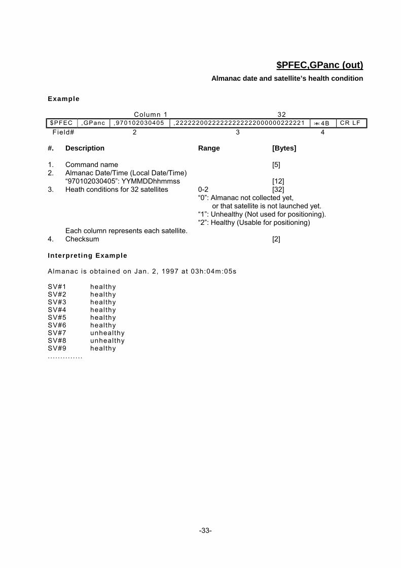
$PFEC,GPanc (out) Almanac date and satellite’s health condition
Example
Column 1 32
$PFEC ,GPanc ,970102030405 ,22222200222222222222000000222221 * 4B CR LF Field# 2 3 4 #. Description Range [Bytes] 1. Command name [5] 2. Almanac Date/Time (Local Date/Time) “970102030405”: YYMMDDhhmmss [12] 3. Heath conditions for 32 satellites 0-2 [32] “0”: Almanac not collected yet, or that satellite is not launched yet. “1”: Unhealthy (Not used for positioning). “2”: Healthy (Usable for positioning) Each column represents each satellite. 4. Checksum [2] Interpreting Example Almanac is obtained on Jan. 2, 1997 at 03h:04m:05s SV#1 healthy SV#2 healthy SV#3 healthy SV#4 healthy SV#5 healthy SV#6 healthy SV#7 unhealthy SV#8 unhealthy SV#9 healthy . . . . . . . . . . . . . .

-34-
$PFEC,GPacc (out) SV(satellite) Accuracy
Example
Column 1 32
$PFEC ,GPacc ,222222XXXXXXXXX77777XXXXXXXXXXBF * 0D CR LF Field# 1 2 3 #. Description Range [Bytes] 1. Command name [5] 2 SV accuracies for 32 satellites [32] 0-F: SV Accuracy in hexadecimal notation X: SV Accuracy not available Each column represents each satellite. 3. Checksum [2] Interpreting Example SV#1 2 SV#2 2 SV#3 2 SV#4 2 SV#5 2 SV#6 2 SV#7 data not avai lable SV#8 data not avai lable SV#9 data not avai lable . . . . . . . . . . . . . .

-35-
$PFEC,GPast (out) Position, altitude, speed, course, local time, etc.
Example
$PFEC ,GPast ,4 ,6 ,1 ,0356 Field#12 3 45
,N34431234 ,E135211234 ,0012347 6 7 8
,970123123456 ,01235 ,1234 ,1345 * 65 CR LF 9 10 11 12 13
#. Description Range [Bytes] 1. Command name [5] 2. Status “4” 0,3-6 [1] “0”: Positioning not performed yet “3”: Stand-alone GPS, 2D “4”: Stand-alone GPS, 3D
“5”: DGPS 2D “6”: DGPS 3D 3. No. of satellites used for positioning (0-9, A-C) “6” 0-9 [1] A: 10 B: 11 C: 12 4. Seed/course calculation status “1” 0-1 [1] “0”: Data invalid (Can’t calculate) “1”: Data valid 5. DOP x100 (2D: HDOP3D: PDOP) “0356” 0000-9999 [4] NOTE: For actual DOP, divide the above value by 100. “0000” is output while positioning is interrupted. 6. Latitude “N”: North/South N or S [1] “34”: degree 00-90 [2] “43”: minute (integer) 00-59 [2] “1234”: minute (fraction) 0000-9999 [4] 7. Longitude “E”: East/West E or W [1] “135”: degree 000-179 [3] “21”: Minute (integer) 00-59 [2] “1234”: Minute (fraction) 0000-9999 [4] 8. Altitude (x10m) “0012347” -009999 to 0179999 [7] NOTE: For actual altitude, divide the above value by 10. 9. Local Date/Time “940123123456”: YYMMDDhhmmss n/a [12] NOTE: (Local date/time)=(UTC)-(Local Zone Time) Unless local zone time information is available, UTC is output.

-36-
10. Speed (x10 km/h) “01235” 00000-18519 [5] NOTE: For actual speed, divide the above value by 10. If speed/course calculation status (field#4) is “0”(invalid), previous output value is held. 11. True Course (x10 degrees) “1234” 0000-3599 [4] NOTE: For actual course, divide the above value by 10. If speed/course calculation status (field#4) is “0”(invalid), output value is held. 12. Magnetic Course (x10 degrees) “1345” 0000-3599 [4] NOTE: For actual course, divide the above value by 10. If speed/course calculation status (field#4) is “0”(invalid), output value is held. 13. Checksum [2]
-37-
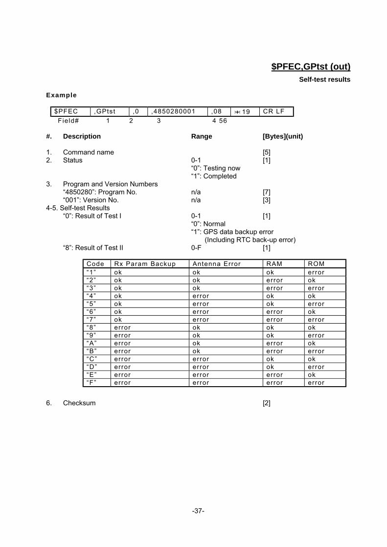
$PFEC,GPtst (out) Self-test results
Example
$PFEC ,GPtst ,0 ,4850280001 ,08 * 19 CR LF Field# 1 2 3 4 56
#. Description Range [Bytes](unit) 1. Command name [5] 2. Status 0-1 [1] “0”: Testing now “1”: Completed 3. Program and Version Numbers “4850280”: Program No. n/a [7] “001”: Version No. n/a [3] 4-5. Self-test Results “0”: Result of Test I 0-1 [1] “0”: Normal “1”: GPS data backup error (Including RTC back-up error) “8”: Result of Test II 0-F [1]
Code Rx Param Backup Antenna Error RAM ROM “1” ok ok ok error “2” ok ok error ok “3” ok ok error error “4” ok error ok ok “5” ok error ok error “6” ok error error ok “7” ok error error error “8” error ok ok ok “9” error ok ok error “A” error ok error ok “B” error ok error error “C” error error ok ok “D” error error ok error “E” error error error ok “F” error error error error
6. Checksum [2]

-38-
$PFEC,GPssd (Answer to $PFEC,GPsrq)
Receiver parameters set by $PFEC,GPset Example
$PFEC ,GPssd ,G001 . . . . . . . . . * hh CR LF Field# 1 2 3.. . . . . . .
$PFEC ,GPssd ,D08 . . . . . . . . . * hh CR LF Field# 12 3.. . . . . . .n+1
#. Description- Range [Bytes] 1. Command name [5] 2-n. Receiver parameters set by $PFEC,GPset are output in two sentences. Each parameter is
preceded by delimiter “,” (comma). n+1. Checksum [2]

-39-
$PFEC,GPisd (Answer to$PFEC,GPirq)
Log output intervals set by $PFEC,GPint Example
$PFEC ,GPisd ,GGA01 . . . . . . . . . * hh CR LF Field# 2 3.. . . . . . . n+1
$PFEC ,GPisd , ts t00 . . . . . . . . . * hh CR LF Field# 2 3.. . . . . . . n+1
#. Description Range [Bytes] 1. Command name [5] 2-n. Log output intervals set by $PFEC,GPint are output in two sentences. Each parameter is
preceded by delimiter “,” (comma). n+1. Checksum [2]

-40-
$PFEC,GPdsd (Answer to $PFEC,GPdrq)
DGPS parameters set by $PFEC,GPdif DGPS parameters set by $PFEC,GPdif are output. Example
$PFEC ,GPdsd ,D0 * 02 CR LF Field# 1 2 3
#. Description Range [Bytes] 1. Command name [5] 2. DGPS parameters set by $PFEC,GPdif are output. 3. Checksum [2]

-41-
$PFEC,GPdie (out)
Receiver status
Example
$PFEC ,GPdie ,1 ,08 ,0 ,0 ,0 * 66 CR LF Field# 1 2 3 4 56 7
#. Description Range [Bytes] 1. Command name [5] 2. DGPS status 0-1 [1] “0”: DGPS data not received yet “1”: Receiving DGPS data NOTE: This flag will be set a few seconds after DGPS data entry. 3. No. of DGPS Satellites “08” n/a [2] 4. DGPS Base station’s Health Condition “0” 0-1 [1] “0”: healthy “1”: unhealthy NOTE: If DGPS station is unhealthy, stand-alone GPS function rather than GPS is performed. 5. DGPS Data Status “0” 0-1 [1] “0”: Normal “1”: Abnormal NOTE: If DGPS data is invalid, stand-alone GPS function rather than DGPS is performed. 6. DGPS Error Code “0” 0-F [1]
Error code Meaning 0 No eeror 1 In Type 1, Type 3 or Type 9 messages, the base stat ion’s health
f ield indicates “unhealthy”. 2 In Type 1 message, UDRE f ield indicates “3” meaning not usable
due to big error. 3 3 or less satel l i tes are avai lable for di f ferent ial data input 4 to F Reserved
7. Checksum [2] Common Errors I f DGPS status ( f ield# 2) can not set to “1”(Receiving DGPS data), or i f DGPS f ix is
not obtainable, suspect: * Inval id format of incoming DGPS data * Insuf f ic ient number of satel l i tes in DGPS data * DGPS stat ion is faulty * DGPS data is too old to correct posit ioning

-42-
$PFEC,GPspe,ANCOUT (in)
Down-load almanac
Issue this sentence when you need the almanac data from GN-79N.
$PFEC,GPspe,ANCOUT * 63 CR LF
As an answer to the above sentence, GN-79N outputs internal almanac data (about 6.0K bytes of
ASCII characters) in the following format.
Note that, after this sentence is received, the GN-79N stops positioning, receiving data, and
outputting the other data than almanac data. After outputting the almanac data, the GN-79N will
restart automatically (Restart clear mode 2).
Example:
#GP,TYP=GP77, 90A927FDE.............980FE3 #GP,END CR LF
You may save the downloaded almanac for future uploading.

-43-
$PFEC,GPspe,ANCINP (in) Up-load almanac
Issue this sentence when you want to send almanac data to GN-79N. This function enables quicker
Time-To-First-Fix.
$PFEC,GPspe,ANCINP * 7A CR LF
Following the above sentence, send almanac data which you saved by $PFEC,GPspe,ANCOUT
before:
#GP,TYP=GP79 90A927FDE.............980FE3 #GP,END CR LF
If uploading is completed successfully, GN-79N outputs the following acknowledgment and restarts
by itself (Restart clear mode 2).
$ANC, OK CR LF
If uploading is failed, GN-79N requests you to send the entire almanac sentence again by outputting
the following error message:
$ANC,NG CR LF
“NG” means No Good.

-44-
5. GEODETIC ID
There are many geodetic systems in the world. Enter a right geodetic system ID in accordance with
your chart or map in use. If the geodetic ID you entered differs from the geodetic system employed
in your chart or map, GPS fixes may be deviated from the actual position on the chart or map.
IDGeodetic System
001: W84: WGS 84 002: W72: WGS 72
*003:TOY-M: TOKYO (Go to 172) :Mean Value (Japan, Korea & Okinawa) 004:NAS-C: NORTH AMERICAN 1927 :Mean Value 005:EUR-M: EUROPEAN 1950 :Mean Value 006:AUG: AUSTRALIAN GEODETIC 1984 :Australia and Tasmania Island 007:ADI-M: ADINDAN :Mean Value (Ethiopia & Sudan) 008:ADI-A: :Ethiopia 009:ADI-C: :Mali 010:ADI-D: :Senegal 011:ADI-B: :Sudan 012:AFG: AFG :Somalia
*013:AIN-A: AIN EL ABD 1970 (Go to 173) :Bahrain Islands 014:ANO: ANNA 1 ASTRO 1965 :Cocos Island 015:ARF-M: ARC 1950 :Mean Value 016:ARF-A: :Botswana 017:ARF-B: :Lesotho 018:ARF-C: :Malawi 019:ARF-D: :Swaziland 020:ARF-E: :Zaire 021:ARF-F: :Zambia 022:ARF-G: :Zimbabwe
*023:ARS-M: ARC 1960 (Go to174) :Mean Value (Kenya & Tanzania) *024:ARS-A: (Go to 175) :Kenya *025:ARS-B: (Go to 176) :Tanzania *026:ASC: ASCENSION ISLAND 1958 (Go to177) :Ascension Island 027:ATF: ASTRO BEACON "E" :Iwo Jima Island 028:TRN: ASTRO B4 SOR. ATOLL :Tern Island 029:SHB: ASTRO POS 71/4 :St. Helena Island 030:ASQ: ASTRONOMIC STATION 1952 :Marcus Island 031:AUA: AUSTRALIAN GEODETIC 1966 :Australia and Tasmania Island 032:IBE: BELLEVUE ( IGN ) :Efate and Erromango Islands 033:BER: BERMUDA 1957 :Bermuda Islands 034:BOO: BOGOTA OBSERVATORY :Colombia 035:CAI: CAMPO INCHAUSPE :Argentina 036:CAO: CANTON ISLAND 1966 :Phoenix Islands 037:CAP: CAPE :South Africa
*038:CAC: CAPE CANAVERAL (Go to 178) :Mean Value (Florida & Bahama Islands) 039:CGE: CARTHAGE :Tunisia 040:CHI: CHATHAM 1971 :Chatham Island (New Zealand) 041:CHU: CHUA ASTRO :Paraguay 042:COA: CORREGO ALEGRE :Brazil 043:BAT: DJAKARTA ( BATAVIA ) :Sumatra Island (Indonesia) 044:GIZ: DOS 1968 :Gizo Island (New Georgia Islands)
*045:EAS: EASTER ISLAND 1967 (Go to 179) :Easter Island 046:EUR-A: EUROPEAN 1950 :Western Europe 047:EUR-E: :Cyprus 048:EUR-F: :Egypt
-45-
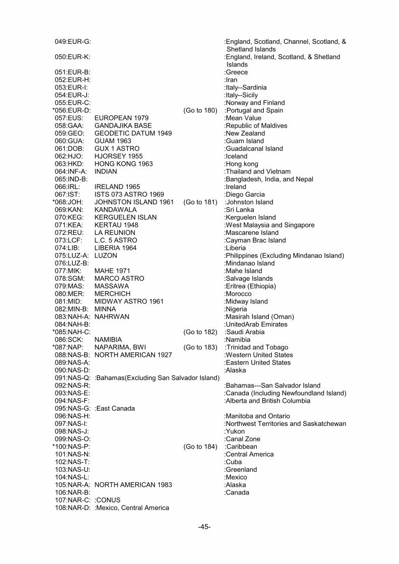
049:EUR-G: :England, Scotland, Channel, Scotland, & Shetland Islands
050:EUR-K: :England, Ireland, Scotland, & Shetland Islands
051:EUR-B: :Greece 052:EUR-H: :Iran 053:EUR-I: :Italy--Sardinia 054:EUR-J: :Italy--Sicily 055:EUR-C: :Norway and Finland
*056:EUR-D: (Go to 180) :Portugal and Spain 057:EUS: EUROPEAN 1979 :Mean Value 058:GAA: GANDAJIKA BASE :Republic of Maldives 059:GEO: GEODETIC DATUM 1949 :New Zealand 060:GUA: GUAM 1963 :Guam Island 061:DOB: GUX 1 ASTRO :Guadalcanal Island 062:HJO: HJORSEY 1955 :Iceland 063:HKD: HONG KONG 1963 :Hong kong 064:INF-A: INDIAN :Thailand and Vietnam 065:IND-B: :Bangladesh, India, and Nepal 066:IRL: IRELAND 1965 :Ireland 067:IST: ISTS 073 ASTRO 1969 :Diego Garcia
*068:JOH: JOHNSTON ISLAND 1961 (Go to 181) :Johnston Island 069:KAN: KANDAWALA :Sri Lanka 070:KEG: KERGUELEN ISLAN :Kerguelen Island 071:KEA: KERTAU 1948 :West Malaysia and Singapore 072:REU: LA REUNION :Mascarene Island 073:LCF: L.C. 5 ASTRO :Cayman Brac Island 074:LIB: LIBERIA 1964 :Liberia 075:LUZ-A: LUZON :Philippines (Excluding Mindanao Island) 076:LUZ-B: :Mindanao Island 077:MIK: MAHE 1971 :Mahe Island 078:SGM: MARCO ASTRO :Salvage Islands 079:MAS: MASSAWA :Eritrea (Ethiopia) 080:MER: MERCHICH :Morocco 081:MID: MIDWAY ASTRO 1961 :Midway Island 082:MIN-B: MINNA :Nigeria 083:NAH-A: NAHRWAN :Masirah Island (Oman) 084:NAH-B: :UnitedArab Emirates
*085:NAH-C: (Go to 182) :Saudi Arabia 086:SCK: NAMIBIA :Namibia
*087:NAP: NAPARIMA, BWI (Go to 183) :Trinidad and Tobago 088:NAS-B: NORTH AMERICAN 1927 :Western United States 089:NAS-A: :Eastern United States 090:NAS-D: :Alaska 091:NAS-Q: :Bahamas(Excluding San Salvador Island) 092:NAS-R: :Bahamas---San Salvador Island 093:NAS-E: :Canada (Including Newfoundland Island) 094:NAS-F: :Alberta and British Columbia 095:NAS-G: :East Canada 096:NAS-H: :Manitoba and Ontario 097:NAS-I: :Northwest Territories and Saskatchewan 098:NAS-J: :Yukon 099:NAS-O: :Canal Zone
*100:NAS-P: (Go to 184) :Caribbean 101:NAS-N: :Central America 102:NAS-T: :Cuba 103:NAS-U: :Greenland 104:NAS-L: :Mexico 105:NAR-A: NORTH AMERICAN 1983 :Alaska 106:NAR-B: :Canada 107:NAR-C: :CONUS 108:NAR-D: :Mexico, Central America

-46-
109:FLO: OBSERVATORIO 1966 :Corvo and Flores Islands (Azores) 110:OEG: OLD EGYPTIAN 1930 :Egypt 111:OHA-M: OLD HAWAIIAN :Mean Value 112:OHA-A: :Hawaii 113:OHA-B: :Kauai 114:OHA-C: :Maui
*115:OHA-D: (Go to 185) :Oahu 116:FAH: OMAN :Oman 117:OGB-M: ORDNANCE SURVEY OF GREAT BRITAIN 1936:Mean Value 118:OGB-A: :England 119:OGB-B: :England, Isle of Man, and Wales 120:OGB-C: :Scotland and Shetland Islands 121:OGB-D: :Wales 122:PLN: PICO DE LAS NIEVIES :Canary Islands 123:PIT: PITCAIRN ASTRO 1967 :Pitcairn Island 124:HIT: PROVISIONAL SOUTH CHILEAN 1963 :South Chile (near 53°S) 125:PRP-M: PROVISIONAL SOUTH AMERICAN 1956 :Mean Value 126:PRP-A: :Bolivia 127:PRP-B: :Chile---Northern Chile (near 19°S) 128:PRP-C: :Chile---Southern Chile (near 43°S) 129:PRP-D: :Colombia 130:PRP-E: :Ecuador 131:PRP-F: :Guyana 132:PRP-G: :Peru 133:PRP-H: :Venezuela 134:PUR: PUERTO RICO :Puerto Rico and Virgin Islands 135:QAT: QATAR NATIONAL :Qatar 136:QUO: QORNOQ :South Greenland 137:MOD: ROME 1940 :Sardinia Islands 138:SAO: SANTA BRAZ :Sao Miguel, Santa Maria Islands (Azores) 139:SAE: SANTO (DOS) :Espirito Santo Island
*140:SAP: SAPPER HILL 1943 (Go to 186) :East Falkland Island 141:SAN-M: SOUTH AMERICAN 1969 :Mean Value 142:SAN-A: :Argentina 143:SAN-B: :Bolivia 144:SAN-C: :Brazil 145:SAN-D: :Chile 146:SAN-E: :Colombia 147:SAN-F: :Ecuador 148:SAN-G: :Guyana 149:SAN-H: :Paraguay 150:SAN-I: :Peru 151:SAN-K: :Trinidad and Tobago 152:SAN-L: :Venezuela 153:SOA: SOUTH ASIA :Singapore 154:POS: SOUTHEAST BASE :Porto Santo and Madeira Islands 155:GRA: SOUTHWEST BASE :Faial, Graciosa, Pico, Sao Jorge and Terceira
Islands *156:TIL: TIMBALAI1948 (Go to 187) :Brunei and East Malaysia (Sarawak and
Sabah) *157:TOY-A: TOKYO (Go to 188) :Japan *158:TOY-B: (Go to 189) :Korea *159:TOY-C: (Go to 190) :Okinawa 160:TDC: TRISTAN ASTRO 1968 :Tristan da Cunha 161:MVS: VITI LEVU 1916 :Viti Levu Island ( Fiji Islands )
*162:ENW: WAKE-ENIWETOK 1960 (Go to 191) :Marshall Islands 163:ZAN: ZANDERIJ :Suriname 164:BUR: BUKIT RIMPAH :Bangka and Belitung Islands (Indonesia ) 165:CAZ: CAMP AREA ASTRO :Camp McMurdo Area, Antarctica 166:GSE: G. SEGARA :Kalimantan Island ( Indonesia ) 167:HEN: HERAT NORTH :Afghanistan
*168:HTN: HU-TZU-SHAN(Go to 192) :Taiwan

-47-
169:TAN: TANANARIVE OBSERVATORY 1925 :Madagascar 170:YAC: YACARE :Uruguay 171:999: RT90 :Sweden 172:TOY-M: TOKYO :Mean Value (Japan, Korea,and Okinawa) 173:AIN-A: AIN EL ABD 1970 :Bahrain Island 174:ARS-M: ARC 1960 :Mean Value (Kenya, Tanzania) 175:ARS-A: :Kenya 176:ARS-B: :Tanzania 177:ASC: ASCENSION ISLAND 1958 :Ascension Island 178:CAC: CAPE CANAVERAL :Mean Value (Florida and Bahama Islands) 179:EAS: EASTER ISLANDS 1967 :Easter Island 180:EUR-D: EUROPEAN 1950 (Cont'd) :Portugal and Spain 181:JOH: JHONSTON ISLAND 1961 :Jhonston Island 182:NAH-C: NAHRWAN :Saudi Arabia 183:NAP: NAPARIMA, BWI :Trinidad and Tobago 184:NAS-P: NORTH AMERICAN 1927 (Cont'd) :Caribbean 185:OHA-D: OLD HAWAIIAN :Oahu 186:SAP: SAPPER HILL 1943 :East Falkland Island 187:TIL: TIMBALAI 1948 :Brunei and East Malaysia (Sarawak and
Sabah) 188:TOY-A: TOKYO :Japan 189:TOY-B: TOKYO :South Korea 190:TOY-C: TOKYO :Okinawa 191:ENW: WAKE-ENIWETOK 1960 :Marshall Islands 192:HTN: HU-TZU-SHAN :Taiwan *193 through 200 are reserved

-48-
201:ADI-E: ADINDAN :Burkina Faso 202:ADI-F: ADINDAN :Cameroon 203:ARF-H: ARC 1950 :Burundi 204:PHA: AYABELLE LIGHTHOUSE :Djibouti 205:BID: BISSAU :Guinea-Bissau 206:DAL: DABOLA :Guinea 207:EUR-T: EUROPEAN 1950 :Tunisia 208:LEH: LEIGON :Ghana 209:MIN-A: MINNA :Cameroon 210:MPO: M'PORALOKO :Gabon 211:NSD: NORTH SAHARA 1959 :Algeria 212:PTB: POINT58 :Mean Solution (Burkina Faso and Niger) 213:PTN: POINTE NOIRE 1948 :Congo 214:SRL: SIERRA LEONE 1960 :Sierra Leone 215:VOR: VOIROL 1960 :Algeria 216:AIN-B: AIN EL ABD 1970 :Saudi Arabia 217:IND-B: INDIAN :Bangladesh 218:IND-I: INDIAN :India and Nepal 219:INF-A: INDIAN 1954 :Thailand 220:ING-A: INDIAN 1960 :Vietnam (near 16N) 221:ING-B: INDIAN 1960 :Con Son Island (Vietnam) 222:INH-A: INDIAN 1975 :Thailand 223:IDN: INDONESIAN 1974 :Indonesia 224:EST: CO-ORDINATE SYSTEM 1937 OF ESTONIA :Estonia 225:EUR-L: EUROPEAN 1950 (Cont'd) :Malta 226:EUR-T: EUROPEAN 1950 (Cont'd) :Tunisia 227:SPK-A: S-42 (PULKOVO 1942) :Hungary 228:SPK-B: S-42 (PULKOVO 1942) :Poland 229:SPK-C: S-42 (PULKOVO 1942) (Cont'd) :Czechoslovakia 230:SPK-D: S-42 (PULKOVO 1942) (Cont'd) :Latvia 231:SPK-E: S-42 (PULKOVO 1942) (Cont'd) :Kazakhstan 232:SPK-F: S-42 (PULKOVO 1942) (Cont'd) :Albania 233:SPK-G: S-42 (PULKOVO 1942) (Cont'd) :Romania 234:CCD: S-JTSK :Czechoslovakia 235:NAS-V: NORTH AMERICAN 1927 (Cont'd) :East of 180W 236:NAS-W: NORTH AMERICAN 1927 (Cont'd) :West of 180W 237:NAR-E: NORTH AMERICAN 1983 :Aleutian Island 238:NAR-H: NORTH AMERICAN 1983 :Hawaii 239:SAN-J: SOUTH AMERICAN 1969 (Cont'd) :Baltra,Galapagos Island 240:AIA: ANTIGUA ISLAND ASTRO 1943 :Antigua,Leeward Island 241:DID: DECEPTION ISLAND :Deception Island,Antarctica 242:FOT: FORT THOMAS 1955 :Nevis, St.Kitts,Leeward Island 243:ISG: ISTS 061 ASTRO 1968 :South Georgia Island 244:ASM: MONTSERRAT ISLAND ASTRO 1958 :Montserrat, Leeward Island 245:REU: REUNION :Mascarene Island 246:AMA: AMERICAN SAMOA 1962 :American Samoa Island 247:IDN: INDONESIAN 1974 :Indonesia 248:KUS: Kusaie ASTRO 1951 :Caroline Island, Fed.States of Micronesia 249:WAK: Wake Island ASTRO 1952 :Wake Atoll 250:EUR-S: EUROPEAN 1950 :Iraq, Israel, Jordan, Kuwait, Lebanon, Saudi
Arabia and Syria 251:HER: HERMANNSKOGEL :Yugoslavia (Prior to 1990) Slovenia, Croatia,
Bosnia and Herzegovina Serbia 252:IND-P: INDIAN :Pakistan 253:PUK: PULKOVO 1942 :Russia 254:VOI: VOIROL 1874 :Tunisia/Algeria