Embed Size (px)
Citation preview
July 20, 2020
NOTICE OF PREPARATION
DRAFT ENVIRONEMNTAL IMPACT REPORT
To: State Clearing House, Agencies and Interested Parties
From: Colusa County Community Development Department
220 12th Street, Colusa CA, 95932
Subject: Notice of Preparation of a Draft Environmental Impact Report (EIR) for
the Proposed Janus Solar PV (Solar Farm), Use Permit Application No.
20-01 (Project).
The Purpose of This Notice of Preparation
The purpose of the Notice of Preparation (NOP) is to comply with the California
Code of Regulations (CCR) Section 15082. The Colusa County Community
Development Department (the Department) is the Lead Agency for the project.
The Use Permit application triggers environmental review and County staff has
determined that an EIR is the appropriate level of review.
The County is requesting input for the preparation of EIR regarding the scope
and content of environmental concerns from your agency’s area of
responsibility. The EIR will be utilized by various agencies for subsequent
approvals. Please provide appropriate contact information for the person(s) in
your agency for consultation regarding this project that is subject to the
California Environmental Quality Act (CEQA).
The NOP is available on the County website at: https://www.countyofcolusa.org/25/Community-Development-Department
Project Location
The project would be located on private property currently used for grazing. The
project site includes three parcels with Assessor Parcel Numbers 018-050-005,
COUNTY OF COLUSA COMMUNITY DEVELOPMENT DEPARTMENT
220 12th Street
Colusa, California 95932
TELEPHONE (530) 458-0480 FAX (530) 458-0482
July 20, 2020
Janus Solar Energy Project, UP #20-01, NOP
Page 2 of 10
018-050-006, and 018-050-013, which are 630.5, 255.7, and 137.7 acres in size,
respectively, for a total area of 1,023.9acres. These parcels are located at 1958
and 1961 Spring Valley Road. The site is more generally located in Township 14
North, Range 3 West, Sections 1, 2 and 3. The project would connect to the
Cortina Substation, which is located on Walnut Drive approximately 3 miles
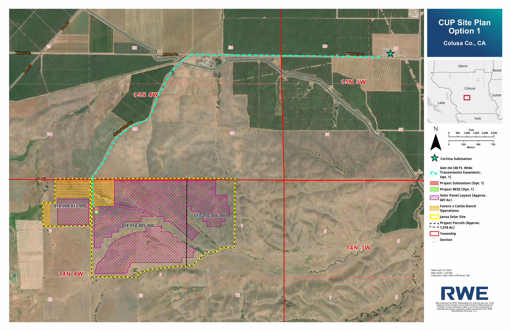
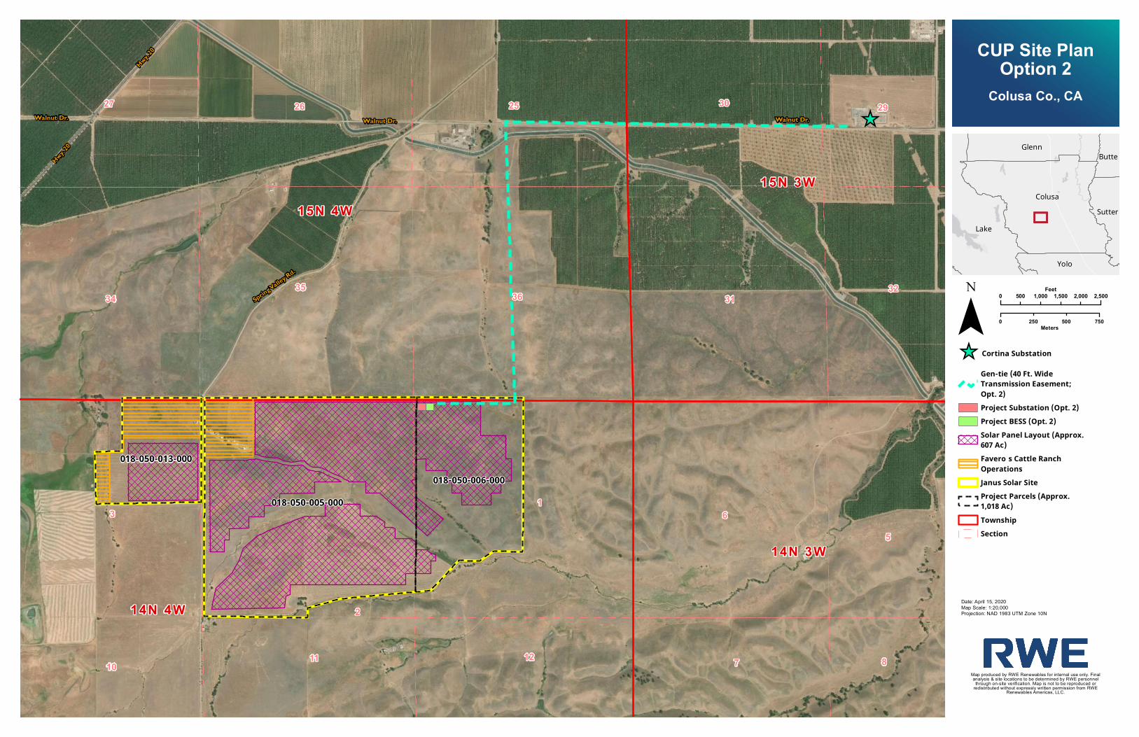
northeast of the project site, as shown on Figure 1 (see Attachment A). The
project is approximately 6.5 miles southwest of the city of Williams. State
Highway 20 runs as close as 1 mile from the project site, to the north and west.
Several alignments for the 60 kilovolt (kV) transmission line from the project site to
the Cortina Substation have been initially identified. The first would be located
on the Colusa County’s right-of-way (ROW) on Walnut Drive and Spring Valley
Road and the second on private land and Walnut Drive ROW from the project
site to the point of interconnection (POI) at the Cortina Substation. Both initial
options are shown on Site Plan Option 1 and Site Plan Option 2 included as
Attachment A. The transmission line may be overhead, underground, or a
combination of both.
Project Setting
The project site is located in a transitional area of Colusa County between the
intensively farmed valley floor and the westerly foothills of the California Coast
Range. Site topography varies from relatively flat to gently rolling hills with
elevation changes of approximately 150 feet.
According to the preliminary studies there are several ephemeral drainages,
riverine drainages, and potential wetlands, all of which have been disturbed
due to the existing ranching activities. Vegetative communities include primarily
non-native grasslands (approximately 706.1 acres), however; smaller areas of
disturbed potential wetland (approximately 4.7 acres), disturbed riparian
woodland approximately (approximately 4.2 acres), and native forbs
(approximately 21.9 acres) are present on the project site.
The preliminary studies also identified existing and potential wildlife that utilize
the habitats found on site. A special status species review was conducted
using the California Natural Diversity Database, California Native Plant Society
Inventory and other agency sources in conjunction with field surveys. This review
identified several potential special status species that have a high to moderate
potential to be present on the site. These species include three plant species,
including two species of tar plant and the adobe lily. Several bird species were
also identified as being on site or having a high to moderate potential to utilize
July 20, 2020
Janus Solar Energy Project, UP #20-01, NOP
Page 3 of 10
the project site. These species included four species of raptors (including
Burrowing Owls and Swainson’s Hawk) and two bat species (Townsends Big
Eared Bat and Red Eared Bat. One invertebrate species, the Tad Pole Shrimp, is
considered to have moderate potential to utilize the site due the potential
wetlands.
The Project site also has cattle ranch facilities located in the northwest corner.
These include a single family residence, and ranching accessory buildings
(approximately 5 acres). The area in close around the homes site and ranching
buildings includes an area of un-vegetated agricultural land and existing corrals
(approximately 225.4 acres).
The Project site is under Williamson Act contract. While energy production is
considered a compatible use under the County’s Williamson Act Program, due
to the size and scope of the project the County is requiring cancellation of that
portion of the contract affected by the project.
Project Description
The project will utilize approximately 650 acres of the 1,023.9 acre project site.
Construction is planned for the end of 2022. The project will be capable of
producing 80 MWs of electricity for distribution on the PG&E grid. A more
detailed description is provided as follows:
Solar Arrays and Inverter Blocks - The project solar PV power generation facilities
include solar arrays and inverter blocks, as shown on the Site Plans, included as
Attachment A. The project’s solar PV modules (also known as panels) would
convert solar energy into direct current (DC) electricity. By design, the solar PV
panels absorb sunlight to generate electrical output by being manufactured
with anti-reflective glass that also minimizes potential for glare. The PV modules
would be mounted together in arrays on a modular tracking system such that
the angle of the panels varies throughout the day. Each tracking assembly
would consist of galvanized steel posts on which the frames which range
between 6 and 10 feet above grade, depending on the topography, as shown
on the Site Plans, included as Attachment A. The project would also include
inverter blocks to convert the DC electricity from the solar arrays to alternating
current (AC) electricity. The inverter blocks would be located along the internal
access roads within the solar arrays. Each inverter block would consist of
enclosed inverter stations and a transformer approximately 10 feet in height
above grade set on concrete or steel foundations, as shown on the Site Plans,
included as Attachment A.
July 20, 2020
Janus Solar Energy Project, UP #20-01, NOP
Page 4 of 10
Related and Supporting Facilities - The project-related supporting facilities
include underground electrical collection lines, an on-site substation, a Battery
Energy Storage System (BESS), a 60-kV transmission line to the point of
interconnection (POI), an operations and maintenance (O&M) facility, internal
service roads, security fencing, gates and lighting, a construction laydown yard,
and other temporary construction areas.
Electrical Collection System - The electrical collection system would be installed
underground. Underground AC electrical cables would be arranged in several
branch circuits to connect the electrical output of the energy facility to the on-
site substation. Cable lengths would vary with the distance of the solar arrays to
the on-site substation.
Substation - The project substation would be located on an approximately 1-
acre area in a corner of the project site within the perimeter fence. The
substation would include a generator step-up transformer to increase the output
voltage from the module blocks (34.5 kV) to the voltage of the 60-kV
transmission line, protective relay and metering equipment, utility and customer
revenue metering, and a station service transformer that would provide power
to the substation and its weatherproof control house.
Energy Storage System - The BESS would be located next to the substation within
a 5-acre area. The BESS would consist of lithium ion battery technology that
would be used to either control electric frequency or store energy from the solar
project. The BESS would be housed in standard shipping containers or inside an
air-conditioned building.
Transmission Line and Point of Interconnection - The 60-kV transmission line would
extend from the project site approximately 2 to 4 miles (depending on the
alignment) along the County ROW or a combination of County ROW and
private land to reach the Walnut Drive substation. The line would be installed on
existing, retrofitted or new poles, underground or a combination of the two.
Operations and Maintenance Facility - The O&M facility would include office
space, storage, and sanitary facilities. The sanitary facilities would drain to an
on-site septic system. Water would be supplied by either on-site wells or trucked
to the site. An equipment storage area and a gravel parking lot for employees,
visitors, and emergency response vehicles would be located adjacent to the
container. The O&M facility would be located with the substation.
July 20, 2020
Janus Solar Energy Project, UP #20-01, NOP
Page 5 of 10
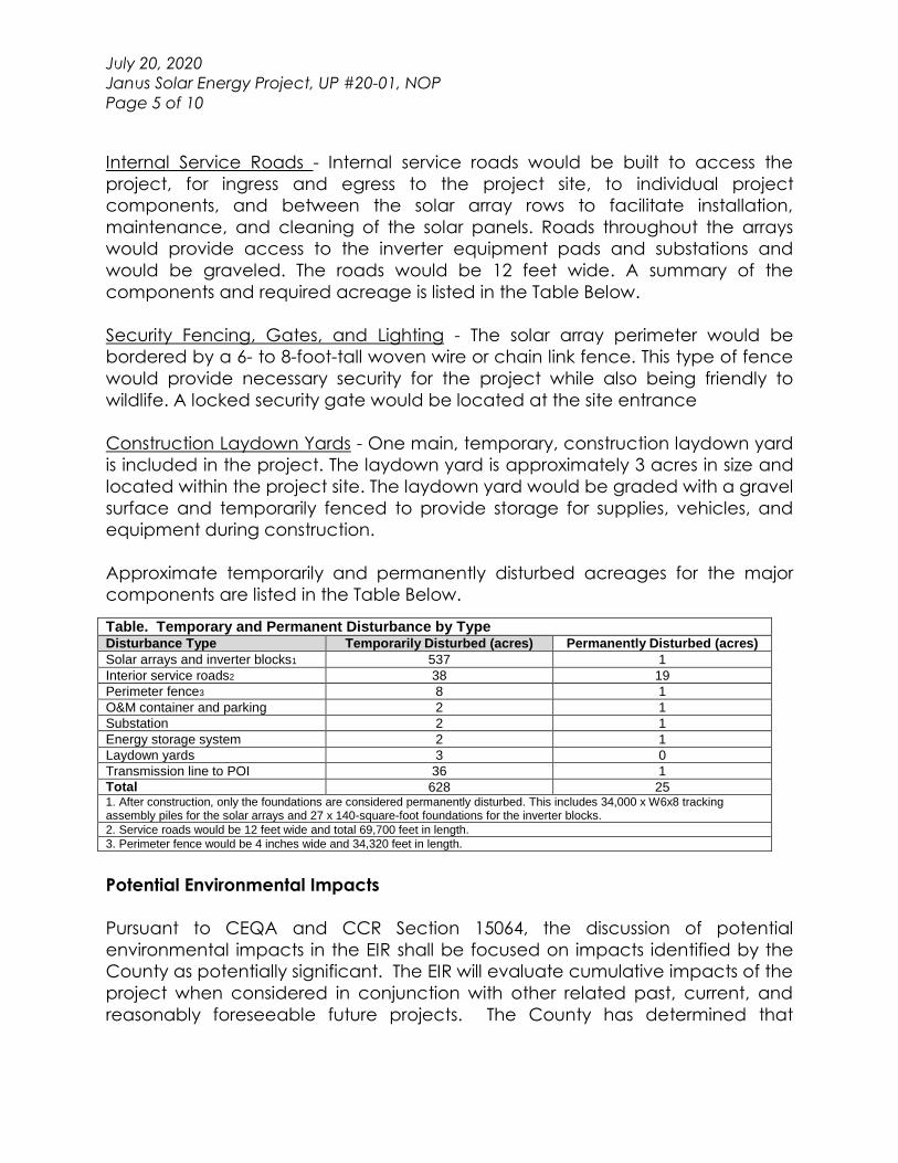
Internal Service Roads - Internal service roads would be built to access the
project, for ingress and egress to the project site, to individual project
components, and between the solar array rows to facilitate installation,
maintenance, and cleaning of the solar panels. Roads throughout the arrays
would provide access to the inverter equipment pads and substations and
would be graveled. The roads would be 12 feet wide. A summary of the
components and required acreage is listed in the Table Below.
Security Fencing, Gates, and Lighting - The solar array perimeter would be
bordered by a 6- to 8-foot-tall woven wire or chain link fence. This type of fence
would provide necessary security for the project while also being friendly to
wildlife. A locked security gate would be located at the site entrance
Construction Laydown Yards - One main, temporary, construction laydown yard
is included in the project. The laydown yard is approximately 3 acres in size and
located within the project site. The laydown yard would be graded with a gravel
surface and temporarily fenced to provide storage for supplies, vehicles, and
equipment during construction.
Approximate temporarily and permanently disturbed acreages for the major
components are listed in the Table Below.
Potential Environmental Impacts
Pursuant to CEQA and CCR Section 15064, the discussion of potential
environmental impacts in the EIR shall be focused on impacts identified by the
County as potentially significant. The EIR will evaluate cumulative impacts of the
project when considered in conjunction with other related past, current, and
reasonably foreseeable future projects. The County has determined that
Table. Temporary and Permanent Disturbance by Type Disturbance Type Temporarily Disturbed (acres) Permanently Disturbed (acres)
Solar arrays and inverter blocks1 537 1
Interior service roads2 38 19
Perimeter fence3 8 1
O&M container and parking 2 1
Substation 2 1
Energy storage system 2 1
Laydown yards 3 0
Transmission line to POI 36 1
Total 628 25 1. After construction, only the foundations are considered permanently disturbed. This includes 34,000 x W6x8 tracking assembly piles for the solar arrays and 27 x 140-square-foot foundations for the inverter blocks.
2. Service roads would be 12 feet wide and total 69,700 feet in length.
3. Perimeter fence would be 4 inches wide and 34,320 feet in length.
July 20, 2020
Janus Solar Energy Project, UP #20-01, NOP
Page 6 of 10
project could result in potential environmental impacts in the following areas,
which will be further evaluated in the EIR.
Aesthetics – The project is located in a rural area surrounded by existing
agricultural uses consisting of grazing lands and scattered residential buildings
and accessory buildings. The placement of PV solar panels and associated
structures on the project site would alter the existing character of the site and
surrounding area. The project site is divided by Spring Valley Road with majority
of the facilities being located to the east of the road. Residents and travelers
and residents in the area would observe alterations to the existing landscape.
The EIR will provide an assessment of project impacts to visual resources, as well
as lighting and glare impacts.
Agriculture and Forestry Resources - The entire project site is designated as
Farmland of Local Importance by the California Farmland Mapping and
Monitoring Program. The project site is surrounded by grazing land. The project
site is under Williamson Act contract. The EIR will provide an assessment of
potential project related impacts to agricultural resources including potential
cancellation of the Williamson Act contract.
Air Quality and Greenhouse Gas Emissions - The EIR will describe regional and
local air quality in the vicinity of the proposed project site and evaluate impacts
to air quality associated with the construction and operation of the project. An
air quality study will be prepared to establish baseline conditions, and project
and cumulative impacts. The proposed project’s estimated air emissions will be
compared to emissions thresholds of the Colusa County Air Pollution Control
District and California Air Resources Board. The EIR will describe existing air
quality conditions within the Sacramento Valley Air Basin and will evaluate the
proposed project’s potential air quality impacts. Potential air quality emissions
include fugitive dust and combustion exhaust. The EIR will also include a
discussion of greenhouse gas emissions and the proposed project’s contribution
to potential cumulative impacts on global climate change.
Biological Resources - Construction of the proposed project may modify biotic
habitats used by sensitive plant and wildlife species. As such, site development
may be regulated by state or federal agencies, subject to the provisions of
CEQA, A preliminary biological assessment special status species review was
completed in November of 2019 and was provided with the application. The
assessment indicated that additional rare plant and Burrowing Owl studies were
needed for seasonal reasons. A wetland delineation study is also required to
July 20, 2020
Janus Solar Energy Project, UP #20-01, NOP
Page 7 of 10
address potential impacts related to Tadpole Shrimp and other potential
wetland species.
Cultural and Tribal Cultural Resources - Although the proposed project will be
constructed on previously disturbed land due to grazing and other agricultural
activities, it cannot be definitively concluded that cultural resources are absent.
Consultation with the Northwest Information Center (NWIC) at Sonoma State for
a cultural resources records search will be conducted. An updated AB 52 Tribal
Consultations Lists and Sacred Land File (SLF) Search was submitted to the
Native American Heritage Commission (NAHC) on July 6, 2020. The NAHC
responded on July 7, 2020, with a list of tribes that are traditionally and culturally
affiliated with the project area. No determination was provided regarding the
SLF. The County has begun the AB 52 process by notifying seven tribes, six from
the NAHC lists and another who has requested consultation in the past.
Depending on the results of the records search and tribal consultation a cultural
resource survey may be required. The EIR will examine the proposed project’s
potential to affect cultural resources and tribal cultural resources.
Energy - The EIR will include an analysis of the project’s potential to result in
impacts on energy conservation and/or consumption.
Geology/Soils and Mineral Resources - Initial construction, buildout, and
operation of the proposed project on the project site could result in impacts
related to geotechnical hazards, including seismicity of the area, potential for
liquefaction and subsidence, potential for soil erosion, soil stability
characteristics, and shrink/swell potential of site soils, as applicable.
Mineral resources in the County are general related to gravel along existing
waterways. While no significant waterways exist on the project site gravel
resources have the potential to be present due to the proximity of the Coast
Range and possible alluvial fans.
It is currently unknown whether the proposed project site soils have the potential
to contain paleontological resources. If such resources exist on the site, ground-
disturbing activities could result in potentially significant impacts. geological
evaluation of the proposed project site will be conducted to establish baseline,
project conditions, and impacts related to geology, soils, mineral resources, and
paleontological resources.
Green House Gas Emissions - The temporary construction activities associated
with the proposed project, which would involve operation of heavy off-road
July 20, 2020
Janus Solar Energy Project, UP #20-01, NOP
Page 8 of 10
equipment, on-road trucks, and construction worker commute trips, would
generate greenhouse gas (GHG) emissions. However, as a solar facility, the
proposed project is expected to displace traditional sources of electricity
production that involves combustion energy sources (e.g., burning coal, fuel oil,
or natural gas). As such, the provision of solar energy by the proposed project
would produce GHG-free electricity that is anticipated to offset GHGs that
would otherwise be generated by traditional sources of electricity. The potential
impacts associated with GHG emissions generated during construction of the
project and the potential GHG offsets resulting from operation of the project will
be evaluated in the EIR. The proposed project’s estimated greenhouse gas
emissions will be evaluated for consistency with the Colusa County 2012 General
Plan Update and 2017 State Scoping Plan.
Hazards and Hazardous Materials - There are no known hazards or hazardous
materials located within the proposed project site according to the Phase 1
Environmental Report provide in the application. The EIR will evaluate the
potential for the proposed project to result in, or be affected by, impacts
associated with hazards and hazardous materials.
Hydrology/Water Quality - According to the Flood Insurance Rate Maps (FIRM)
prepared by the Federal Emergency Management Agency (Map Numbers
06011C0625F and 06011C0650F), the majority of the project site is located within
Zone X. Zone X is an area determined to be outside the 0.2 percent annual
chance floodplain. There are locations along drainages that are identified as
Zone A and are considered to be with the 100 Year Flood Plain. Substantial
grading and ground work will be required for project construction storm water
runoff needs to be evaluated during and construction. The EIR will analyze the
proposed project’s impacts on hydrology and water quality.
Land Use/Planning - The EIR will describe the proposed project’s potential effects
on existing and planned uses on and around the project site. The General Plan
land use designation is Upland Agricultural. The site is zoned as Foothill
Agriculture (FA), which has a minimum parcel size of 80 acres. The designations
are intended to promote and support agricultural uses such as grazing. The FA
zoning designation allows the installation of energy production for off-site use
with a Use Permit; however, the EIR will provide a discussion of relevant local
plans and policies because conflicts with other uses, including agricultural
operations, could potentially result in environmental impacts.
Noise - The EIR will describe the noise levels associated with proposed project
construction and operations will compare these levels to applicable noise
July 20, 2020
Janus Solar Energy Project, UP #20-01, NOP
Page 9 of 10
thresholds to determine whether the proposed project would result in a
significant noise impact. A noise study will be prepared to establish baseline,
project, and cumulative impacts.
Population/Housing - The EIR will evaluate the project’s effect on population and
housing in the local area based on estimations of project employment and
distribution of the employees by place of residence.
Public Services - The EIR will evaluate the proposed project’s potential to create
an adverse impact to schools, and will also evaluate effects on local police and
fire services along with parks and regional recreational facilities.
Recreation - Although unlikely due to the nature of the proposed project,
recreational activities such as hunting in the vicinity of the project will be
analyzed in the EIR.
Transportation/Traffic - The EIR will evaluate the proposed project’s impact on
regional and local transportation facilities based on a transportation analysis
that will assess both construction-related impacts (heavy truck trips and
construction worker trips), as well as operational impacts (employee and visitor
trips). Impacts to roadways would be limited to construction-related activities of
the project. Construction-related vehicles would primarily access the project site
from State Route 20, Walnut Drive and Spring Valley Road. The EIR will evaluate
traffic safety, road damage impacts, and agricultural aircraft operations.
Utilities and Service Systems - The proposed project would not require
extension/connection to urban services such as potable water service,
wastewater treatment, and storm-water drainage. However, the EIR will analyze
drainage, wastewater, natural gas, and electrical systems and the proposed
project’s impact on these systems. Of primary concern is water supply for
construction activity mitigation and solar facility maintenance. A water supply
assessment needs to be conducted for the EIR analysis. The EIR will also
describe the existing solid waste facilities that serve the project site.
Wildfire – Preliminary comments were received from Cal Fire and Williams Fire
Protection Authority on the project. The EIR will incorporate the comments
received into the Wildfire and Public Services analysis. The EIR will evaluate the
potential impacts of the project related to Wildfire.
GROWTH INDUCEMENT - The EIR will evaluate the proposed project’s potential for
growth inducement resulting from the construction and operation of the solar
July 20, 2020
Janus Solar Energy Project, UP #20-01, NOP
Page 10 of 10
energy facility, as well as new demand for housing, and goods and services. The
effect of primary and secondary increases in employment and economic
activity will be discussed.
CUMULATIVE IMPACTS - The EIR will discuss the incremental contribution of the
proposed project to cumulative effects of other past, current, and planned and
reasonably foreseeable projects in the vicinity. The summary of projects method
will be used where applicable. Also, to the extent feasible, the Cumulative
Impacts section will quantify the degree of severity of any cumulative impact.
ALTERNATIVES EVALUATED IN THE EIR - In accordance with the CEQA Guidelines
Section 15126.6, the EIR will describe a reasonable range of alternative to the
proposed project that are capable of meeting most of the proposed project’s
objectives, but would avoid or substantially lessen any of the significant effects
of the proposed project. The EIR will also identify any alternatives that were
considered but rejected by the Lead Agency as infeasible and briefly explain
the reasons why. The EIR will also provide an analysis of the No project
Alternative.
OPPORTUNITY FOR PUBLIC COMMENT
Interested individuals, groups, and agencies may provide to the County of
Colusa Community Development Department, written comments on topics to
be addressed in the EIR for the proposed project. Because of time limits
mandated by state law, comments should be provided no later than 5:00 p.m.
August 19, 2020. Agencies that will need to use the EIR when considering permits
or other approvals for the proposed project should provide the name of a staff
contact person. Please send all comments to:
Kent Johanns, Associate Planner
Colusa County Community Development Department
220 12th Street, Colusa CA, 95932
(530) 458-0480
Service Layer Credits: Esri, HERE, Garmin, (c) OpenStreetMapcontributors, and the GIS user communitySource: Esri, DigitalGlobe, GeoEye, Earthstar Geographics,CNES/Airbus DS, USDA, USGS, AeroGRID, IGN, and the GISUser Community
_̂
56
7 8
2930
3132
252627
3435
36
1
2
3
1011 12
018-050-013-000
018-050-005-000018-050-006-000
14N 3W
15N 3W15N 4W
14N 4W
Colusa Co., CA
Butte
Colusa
Glenn
LakeSutter
Yolo
Map produced by RWE Renewables for internal use only. Finalanalysis & site locations to be determined by RWE personnel
through on-site verification. Map is not to be reproduced orredistributed without expressly written permission from RWERenewables Americas, LLC.
0 2,500500 1,000 1,500 2,000Feet
0 750250 500Meters¯
Date: April 15, 2020Map Scale: 1:20,000Projection: NAD 1983 UTM Zone 10N
_̂ Cortin a Su bs tatio nGen -tie (40 Ft. WideTran s mis s io n Easemen t;Opt. 1)Projec t Su bs tatio n (Opt. 1)Projec t BESS (Opt. 1)Solar Pan el Layo u t (Appro x.607 Ac )Favero ’s Cattle Ran c hOperatio n sJan u s So lar SiteProjec t Parc els (Appro x.1,018 Ac )To w n s hipSec tio n
CUP Site PlanOption 1
Walnut Dr.Walnut Dr. Walnut Dr.
Hwy. 20
Hwy. 20
Spring Valley Rd.
Service Layer Credits: Esri, HERE, Garmin, (c) OpenStreetMapcontributors, and the GIS user communitySource: Esri, DigitalGlobe, GeoEye, Earthstar Geographics,CNES/Airbus DS, USDA, USGS, AeroGRID, IGN, and the GISUser Community
_̂
56
7 8
2930
3132
252627
3435
36
1
2
3
1011 12
018-050-013-000
018-050-005-000018-050-006-000
14N 3W
15N 3W15N 4W
14N 4W
Colusa Co., CA
Butte
Colusa
Glenn
LakeSutter
Yolo
Map produced by RWE Renewables for internal use only. Finalanalysis & site locations to be determined by RWE personnel
through on-site verification. Map is not to be reproduced orredistributed without expressly written permission from RWERenewables Americas, LLC.
0 2,500500 1,000 1,500 2,000Feet
0 750250 500Meters¯
Date: April 15, 2020Map Scale: 1:20,000Projection: NAD 1983 UTM Zone 10N
_̂ Cor tin a Sub s tationGen -tie (40 Ft. WideTran s m ission Easem en t;Opt. 2)Project Sub s tation (Opt. 2)Project BESS (Opt. 2)Solar Pan el Layout (Approx.607 Ac)Favero’s Cat tle Ran chOperation sJan us Solar SiteProject Parcels (Approx.1,018 Ac)Tow n shipSection
CUP Site PlanOption 2
Walnut Dr.Walnut Dr. Walnut Dr.
Hwy. 20
Hwy. 20
Spring Valley Rd.