Embed Size (px)
Citation preview

www.pca.state.mn.us • 651-296-6300 • 800-657-3864 • Use your preferred relay service • Available in alternative formats p-ear2-144i Page 1 of 2
Notice of Availability of an Environmental Assessment
Worksheet (EAW) Catalpa, LLC
Doc Type: Public Notice
Public comment information EAW public comment period begins: April 30, 2018
EAW public comment period ends: 4:30 p.m. on July 3, 2018
Notice published in the EQB Monitor: June, 11, 2018
Permit public comment period begins: April 30, 2018
Permit public comment period ends: 4:30 p.m. on July 3, 2018
Facility specific information Facility name and location: Facility contact:
Catalpa, LLC Fillmore County Newburg Township Township 101N, Range 8W
Catalpa, LLC Brad Herman 10 9th St SW Waukon, IA 52172 Phone: 563-568-4472
MPCA contact information MPCA EAW contact person: MPCA Permit contact person:
Charles Peterson Resource Management and Assistance Division Minnesota Pollution Control Agency 520 Lafayette Road North St. Paul, MN 55155 Phone: 651-757-2856 Fax: 651-297-2343 Email: [email protected] Admin staff phone: 651-757-2100
Mark P. Gernes, Environmental Specialist 3 Feedlot Section, Watershed Division Minnesota Pollution Control Agency 18 Wood Lake Drive SE Rochester, MN 55904 Phone: 507-206-2643 Fax: 507-280-5513 Email: [email protected]
General information The Minnesota Pollution Control Agency (MPCA) is extending the Environmental Assessment Worksheet (EAW) review and comment period to July 3, 2018. The MPCA uses the EAW and any comments received to evaluate the potential for significant environmental effects from the project and decide on the need for an Environmental Impact Statement (EIS).
An electronic version of the EAW is available on the MPCA Environmental Review webpage at https://www.pca.state.mn.us/eaw. If you would like a copy of the EAW or NPDES Permit or have any questions on the EAW or NPDES Permit, contact the appropriate person(s) Description of proposed project Catalpa, LLC proposes to construct and operate a new 1,992 animal unit swine farrowing facility (4,980 sows) in Sections 7 and 18, Newburg Township, Fillmore County consisting of two barns, an animal mortality composting building, one stormwater basin, and a livestock watering well.

www.pca.state.mn.us • 651-296-6300 • 800-657-3864 • Use your preferred relay service • Available in alternative formats p-ear2-144i Page 2 of 2
The Minnesota Pollution Control Agency will host a public informational meeting on Tuesday, June 19, at 6:00 pm to 8:00 pm, regarding the Environmental Assessment Worksheet and the proposed feedlot permit for Catalpa LLC. The meeting will be in Mabel, Minnesota, at the Mabel Community Center, 201 Main St S, Mabel, MN 55954. The MPCA is extending the comment period to Tuesday July 3, 2018 at 4:30 PM. All comments received on the EAW to date will be included in the record for the EAW and do not need to be resubmitted.
To submit written comments on the EAW NPDES Permit Written comments on the EAW must be received by the MPCA EAW contact person within the comment period listed above.
For information on how to comment on the (insert type of) Permit, contact the MPCA Permit contact person listed above.
NOTE: All comment letters are public documents and will be part of the official public record for this project.
Need for an EIS The MPCA Commissioner will make a final decision on the need for an EIS after the end of the comment period.

p-ear1-05 TDD (for hearing and speech impaired only): 651-282-5332
Printed on recycled paper containing 30% fibers from paper recycled by consumers
Alternative EAW Form for Animal Feedlots
ENVIRONMENTAL ASSESSMENT WORKSHEET Note to preparers: This form is authorized for use only for the preparation of Environmental Assessment Worksheets (EAWs) for animal feedlots. Project proposers should consult the guidance Guidelines for Alternative EAW Form for Animal Feedlots (also available at the Minnesota Environmental Quality Board (EQB) website https://www.eqb.state.mn.us/content/environmental-review-guidance-practitioners-and-proposers. or by calling 651-296-6300) regarding how to supply information needed by the Responsible Government Unit to complete the worksheet form. Note to reviewers: The Environmental Assessment Worksheet (EAW) provides information about a project that may have the potential for significant environmental effects. This EAW was prepared by the Minnesota Pollution Control Agency (MPCA), acting as the Responsible Governmental Unit (RGU), to determine whether an Environmental Impact Statement (EIS) should be prepared. The project proposer supplied reasonably accessible data for, but did not complete the final worksheet. Comments on the EAW must be submitted to the MPCA during the 30-day comment period which begins with notice of the availability of the EAW in the Minnesota Environmental Quality Board (EQB) Monitor. Comments on the EAW should address the accuracy and completeness of information, potential impacts that are reasonably expected to occur that warrant further investigation, and the need for an EIS. A copy of the EAW may be obtained from the MPCA by calling 651-757-2100. An electronic version of the completed EAW is available at the MPCA website www.pca.state.mn.us/eaw. 1. Basic Project Information.
A. Feedlot Name: Catalpa, LLC B.
Feedlot Proposer:
Catalpa, LLC
C.
RGU:
Minnesota Pollution Control Agency
Technical
Contact Person Jeff Bauman
Contact Person
Charles Peterson
and
Title Project Consultant- Anez Consulting, Inc.
and Title
Project Manager
Address 1700 Technology Drive NE Address 520 Lafayette Road North Willmar, Minnesota 56201 St. Paul, Minnesota 55155-4194 Phone 320-235-1970 Phone 651-757-2856 Fax 320-235-1986 Fax 651-297-2343 E-mail [email protected] E-mail [email protected]

Catalpa LLC Environmental Assessment Newburg Township, Fillmore County, Minnesota 2 Worksheet
D. Reason for EAW Preparation: (check one) EIS
Scoping
Mandatory EAW
X
Citizen Petition
RGU Discretion
Proposer Volunteered
If EAW or EIS is mandatory give EQB rule category
subpart number and name: Minn. R. 4410.4300, subp. 29A Feedlots
Project Location: County Fillmore City/Twp Newburg Township SE ¼ SE ¼ Section 7 Township 101N Range 8W NE ¼ NE ¼ Section 18 Township 101N Range 8W Watershed (name and 4-digit code):
Root 0704
F. Attach each of the following to the EAW:
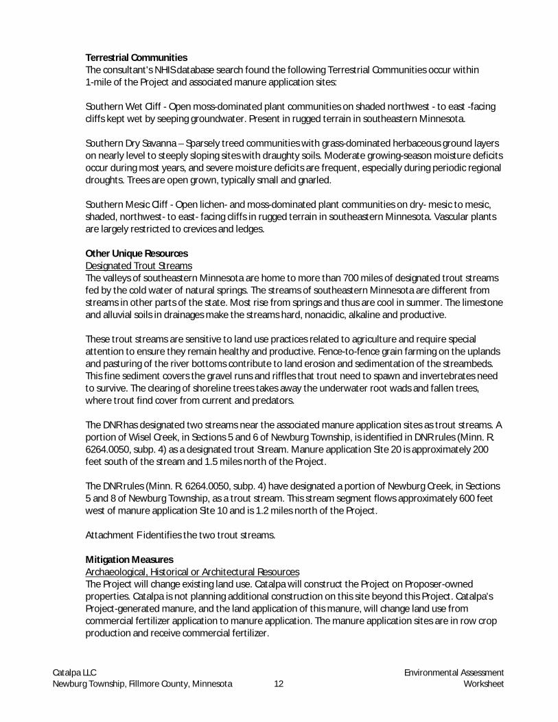
Attachment A – Project Location Map Attachment B – USGS Topographic Map, Fillmore County Attachment C – Project Site Plan Attachment D – Neighboring Residences, Water Supply Wells, Sensitive Features, 1-Mile Radius Attachment E – Overview Map of Land Application Sites Attachment E-1 – Setback Map for Land Application Site 22 Attachment E-2 – Setback Map for Land Application Sites 13, 16, 17, and 18 Attachment E-3 – Setback Map for Land Application Site 14 Attachment E-4 – Setback Map for Land Application Site 7 Attachment E-5 – Setback Map for Land Application Sites 6, 9, and 10 Attachment E-6 – Setback Map for Land Application Sites 4, 20, and 21 Attachment E-7 – Setback Map for Land Application Sites 1, 2, 3, 5, 15, 23, and 24 Attachment E-8 – Setback Map for Land Application Sites 8, 11, 12, and 25 Attachment F – Cumulative Impacts – Water, Wells Map Attachment G – Air Quality Modeling Analysis Attachment H – Minnesota Archaeological Inventory and Historic Structures Inventory Results Attachment I –Natural Heritage Information System Search Report Attachment J – DNR Well Construction Preliminary Assessments Attachment K – Minnesota Department of Health Public Well Report
The following documents are on file and available for review by contacting Mark Gernes of the MPCA’s Rochester Office at 507-206-2643 or at [email protected].
· State of Minnesota General Animal Feedlot National Pollutant Discharge Elimination System (NPDES) Permit (Feedlot Permit) application and associated documents
· Emergency Response Plan · Manure Management Plan (MMP)
G. Project summary of 50 words or less to be published in the EQB Monitor.
Catalpa, LLC proposes to construct and operate a new 1,992 animal unit (AU) swine farrowing facility (4,980 sows) in Sections 7 and 18, Newburg Township, Fillmore County consisting of two barns, an animal mortality composting building, one stormwater basin, and a livestock watering well.

Catalpa LLC Environmental Assessment Newburg Township, Fillmore County, Minnesota 3 Worksheet
H. Please check all boxes that apply and fill in requested data:
Animal Type Number Existing/Proposed Type of Confinement Sows 4,980 head Total Confinement
I. Project magnitude data.
Total acreage of farm: 282 acres Number of AUs proposed in this project: 1,992 AU Total AU capacity at this location after project construction: 1,992 AU Acreage required for manure application: 732 acres/year
J. Describe construction methods and timing.
Catalpa, LLC (Catalpa) is planning to construct a swine finishing feedlot in in Sections 7 and 18, Newburg Township, Fillmore County as shown in Attachments A, B, and C (Project). The Project will house up to 1,992 animal units (AU)1 (4,980 sows) and consists of constructing the following items:
· One 184-foot x 371-foot total confinement, power-ventilated pull-plug farrowing barn with 2-foot deep concrete liquid manure storage area (LMSA)
· One 202-foot x 513-foot total confinement, power-ventilated breeding/gestation barn with 12-foot deep concrete LMSA
· One 24-foot x 160-foot animal mortality composting building with 30-foot apron · One well for livestock watering utilizing 8.8 million gallons per year · One 30,815 foot3 stormwater infiltration basin
Catalpa plans to begin construction in spring of 2018, beginning with the installation of stormwater erosion prevention and sediment control best management practices (BMPs), including silt fence and top soil stripping and stockpiling. Catalpa will utilize soils excavated from the location of the proposed barns to create the site driveway, the berm for the stormwater basin and as material to grade stormwater away from the barns. Catalpa will place the perimeter drain tile beneath the footings of the LMSA for the proposed barns to relieve any seasonal saturation and limit any hydrostatic pressure on the LMSA walls. The drain tile will also help dewater the Project excavation area, if necessary, due to the presence of perched groundwater following precipitation events. Catalpa has designed the perimeter drain tile to discharge to the surface up-gradient from the stormwater detention pond, allowing Catalpa to observe that the tile is operational and identify any seepage from the LMSA if a leak were to occur. Catalpa will install the LMSA, perimeter drain tile, driveway, and utilities at the same time. Construction will include placement of the concrete for the LMSA floors, building and column footings and the animal mortality composting building after placement of reinforcing steel and concrete forms. Catalpa will follow the wall and column construction with placement of precast beams and slats, installation of equipment, and final grading with the installation of permanent stormwater treatment methods. Catalpa will direct stormwater away from the site through final grading and permanent vegetative cover.
1 An “animal unit” or “AU” is a unit of measure developed to compare the differences in the amount of manure produced by livestock species. The “AU” is standardized to the amount of manure produced on a regular basis by a slaughter steer or heifer, which also correlates to 1,000 pounds of body weight. The “AU” is used for administrative purposes by various governmental entities for permitting and recordkeeping.

Catalpa LLC Environmental Assessment Newburg Township, Fillmore County, Minnesota 4 Worksheet
Catalpa expects to complete construction in the fall of 2018. Catalpa’s actual construction dates are dependent on completion of the environmental review process, issuance of the Minnesota Department of Natural Resources (DNR) Water Appropriation Permit, and issuance of the Feedlot Permit2, which contains construction stormwater requirements from the MPCA as well as Fillmore County permits and approvals.
K. Past and future stages. Is this project an expansion or addition to an existing feedlot? Yes No Are future expansions of this feedlot planned or likely? Yes No If either question is answered yes, briefly describe the existing feedlot (species, number of animals and AUs, and type of operation) and any past environmental review or the anticipated expansion.
2. Land uses and noteworthy resources in proximity to the site. A. Adjacent land uses. Describe the uses of adjacent lands and give the distances and directions to
nearby residences, schools, daycare facilities, senior citizen housing, places of worship, and other places accessible to the public (including roads) within one mile of the feedlot and within or adjacent to the boundaries of the manure application sites. The Project is in Fillmore County. All manure application sites associated with the Project are also in Fillmore County. Project Site There are 11 residences located within 1-mile of the Project.
Fillmore County setback rules require the Project to be at least 1,000 feet from neighboring residences, 0.50 mile from homes within city limits, and 100 feet from the centerline of any trails. The nearest neighbor is 1,635 feet northwest of the Project. The Project is approximately 1.2 miles southwest of the unincorporated city of Newburg and approximately 902 feet from the nearest property line. Attachment D shows the location of the neighbors within 1-mile of the Project. All residences are in Fillmore County.
· Non-farm residence 0.89 miles north · Farm residence 0.71 miles north · Farm residence 0.76 miles northeast · Farm residence 0.95 miles northeast · Farm residence 0.89 miles southeast · Non-farm residence 0.95 miles southwest · Farm residence 0.47 miles southwest · Non-farm residence 0.58 miles southwest · Non-farm residence0.89 miles southwest · Farm residence 0.31 miles northwest · Non-farm residence 0.76 miles southwest
2 The Feedlot NPDES Permit is required for a Concentrated Animal Feeding Operation capable of holding 1,000 or more AUs.

Catalpa LLC Environmental Assessment Newburg Township, Fillmore County, Minnesota 5 Worksheet
Manure Application Sites Twenty-three of the 24 manure application sites are within 3 miles of the Project with one manure application site surrounding the Project and one application site 4.5 miles away. All 24 sites are in Fillmore County in Newburg, Preble, and Amherst Townships. The majority of the manure application sites are currently cultivated in a row-crop rotation (i.e. corn, soybeans). Attachment E shows the locations of the manure application sites. Attachments E-1 to E-8 show the locations of sensitive features in relation to application sites. Site 1: (Attachment E-7) A 55.9-acre site in the mid-western half of Section 18 in Newburg Township 0.50 miles southwest of the Project and bordered by County Road 28 to the east, and Site 15 to the north. There is a residence adjacent to the north edge of the site, a residence adjacent to the southeast corner of the site, and another residence 0.2 miles from the northwest corner of the site. There is a grassed waterway in the southeast part of the site. Site 2: (Attachment E-7) A 32.9-acre site in the western half of the northeast quarter of Section 18 and a small portion in the southwest quarter of the southeast quarter of Section 7, Newburg Township 0.12 miles southwest of the Project and bordered by County Road 28 to the west. There is a small pond 200 feet southeast of the site, and grassed waterways in the southern, eastern, and northern parts of the site. There are residences 0.15 miles from the northern tip and 300 feet south of the site. Site 3: (Attachment E-7) A 145-acre site that surrounds the Project, it straddles the eastern half of the border between Sections 18 and 7 in Newburg Township. County Road 28 borders the site to the northwest. There is a residence 260 feet from the west side of the site. An intermittent tributary to an unnamed creek, currently farmed, runs through the southeast part of the site. There is a grassed waterway in the northeast part of the site. This unnamed creek runs adjacent to the northeast side of the site. There is a residence 0.30 miles northeast of the site. Site 4: (Attachment E-6) An 87.1-acre site primarily in the eastern half of the northwest quarter of Section 7, Newburg Township 0.30 miles northwest of the Project and bordered by County Road 24 to the north and County Road 28 to the east. There is a residence adjacent to the northwest corner of the site, and a residence 0.1 miles from the southern end of the site. There is a karst feature: a spring approximately 400 feet north of the site and a sinkhole along the south edge of the site. Site 5: (Attachment E-7) A 76-acre site divided into two parcels by an intermittent stream, in the southeast quarter of Section 18 in Newburg Township 0.6 miles south of the Project and bordered by County Road 28 to the west and 130th Street to the south. There are grassed waterways in the eastern and western sides of the sites. There are residences/private wells adjacent to the west and north borders of the site. Site 6: (Attachment E-5) A 127-acre site in the northeast corner of Section 4 in Newburg Township 2.2 miles northeast of the Project and bordered by 160th Street to the north, 431st Avenue to the east, and 156th Street to the south. There is an intermittent stream in the southwest corner of the site. A second intermittent stream that is a tributary to a designated trout stream runs 0.18 miles north of the site. A public well is adjacent to the northeast corner of the site. Grassed waterways are present throughout the site. Site 7: (Attachment E-4) A 58.9 acre site divided by an intermittent stream into a northeast parcel and a larger southeast parcel, in the northern half of the southwest quarter of Section 34 in Preble Township, and 3.2 miles northeast of the Project and bordered by 431st Avenue to the west. There is a small pond 0.12 miles north of the site. There is a private well 70 feet west of the site, and an

Catalpa LLC Environmental Assessment Newburg Township, Fillmore County, Minnesota 6 Worksheet
intermittent stream flows out of the northwest corner of the site. A tributary to a designated trout stream runs 0.15 miles southwest of the site, and another tributary to a designated trout stream 0.3 miles northwest of the site. Grassed waterways occur throughout both portions the site. Site 8: (Attachment E-8) A 90.6-acre site in the south half of Section 19 in Newburg Township 1.5 miles south of the Project and bordered by County Road 28 to the east. There is a residence and private well adjacent to the east side of the site, and another residence and private well 0.2 miles southwest of the site. An intermittent stream and small pond are adjacent to the southwest corner of the site. Grassed waterways are throughout the site. Site 9: (Attachment E-5) A 122-acre site in the southern half of Section 4 and a small portion in the northwest quarter of the northwest quarter of Section 9 in Newberg Township 1.5 miles northeast of the Project and bordered by 156th Street to the north, 431st Avenue to the east and 421st Avenue to the west. An intermittent stream runs through the southwest part of the site, and a tributary to a designated trout stream runs adjacent to the southwest corner of the site. A small pond is located 0.3 miles north of the site. Grassed waterways are throughout the site. A residence and private well are 80 feet west of the site. Site 10: (Attachment E-5) A 269-acre site in the south half of Section 4, the north half of Section 9, and northeast quarter of Section 8 in Newburg Township 1.2 miles northeast of the Project and bordered by 431st Avenue to the east and 421st Avenue to the west. An intermittent stream is in the southern part of the site. The Newburg Methodist Church, a public well and multiple residences are adjacent to the southwest tip of the site. County Road 24 runs close along the southern edge of the site, and a designated trout stream runs 0.12 miles to the west of the site. A karst feature (spring) is 425 feet south of the site. Grassed waterways occur throughout the site. Site 11: (Attachment E-8) A 33.8-acre site in the southeast quarter of the southeast quarter of Section 19 in Newburg Township 1.8 miles south of the Project and bordered by County Road 28 to the west and 12th Street to the south. There is a residence and private well adjacent to the southwest corner of the site. There is a grassed waterway in the western part of the site. Site 12: (Attachment E-8) A 32.3-acre site mostly in the southwest quarter of the southeast quarter and the southeast quarter of the southwest quarter of Section 19 in Newburg Township 1.8 miles south of the Project and bordered by 120th Street to the south and County Road 28 to the east. There are two karst features (springs) near the site, one 285 feet from the southern edge of the site, and another 584 feet from the southwest tip of the site. There is a small pond adjacent to the western edge of the site. An intermittent stream is adjacent to the southwest tip of the site, and a grassed waterway is in the central part of the site. Site 13: (Attachment E-2) A 42.3-acre site southwest quarter of the southeast quarter of Section 25 and the northwest quarter of the northeast quarter of Section 36 in Amherst Township 3.0 miles northwest of the Project and bordered by Deer Road to the east. An area of moderate biodiversity significance is adjacent to the northern border of the site. There is a karst feature (sinkhole) 1016 feet from the south of the site. There are two residences with private wells adjacent to the north and south border of the site. A grassed waterway and intermittent stream occur within the site. Site 14: (Attachment E-3) A 16.4-acre site divided into one small parcel and one large one, in the northwest of the southwest quarter of Section 32 in Preble Township 2.3 miles from the Project and bordered by Cedar Valley road to the east and County Road 18 to the north. There is an area of moderate biodiversity significance (WiseI Creek AMA) adjacent to the southern and eastern borders of

Catalpa LLC Environmental Assessment Newburg Township, Fillmore County, Minnesota 7 Worksheet
the site. There is a private well 0.15 miles from the northeast corner of the site and a designated trout stream runs 0.16 miles east of the site. Grassed waterways occur within the site. Site 15: (Attachment E-7) A 46.2-acre site in the southeast of the northwest quarter of Section 18 in Newburg Township, 0.3 miles southwest of the Project and bordered by County Road 28 to the east. There is a residence adjacent to the west of the site, and grass waterways within the western and northern parts of the site. Site 16: (Attachment E-2) A 37.3-acre site in the west half of the southwest quarter of Section 31 in Preble Township 2.0 miles northwest of the Project and bordered by 403rd Avenue to the east. A tributary to a designated trout stream runs adjacent to the northeast corner of the site. There are three residences private wells adjacent to the southern border of the site. A designated trout stream runs 0.15 miles south of the site. Grassed waterways are present within the north half of the site. Site 17: (Attachment E-2) A 32-acre site in the northeast of the southeast quarter of Section 36 in Amherst Township 2.4 miles northwest of the Project and bordered by County Road 18 to the north and Deer Road to the west. A karst feature (sinkhole) is 900 feet from the northwest corner of the site, and an intermittent stream is 0.1 miles from the western border of the site. A tributary to a designated trout stream runs 0.1 miles northeast of the site. There are residences/private wells adjacent to the north, west and southwest borders of the site. Grassed waterways occur in the north half of the site. Site 18: (Attachment E-2) A 31.6-acre site in the southeast of the northeast quarter of Section 36 in Amherst Township 2.7 miles northwest of the Project and bordered by County Road 18 to the south and Deer Road to the west. There is a karst feature (sinkhole) 600 feet west of the western border of the site. Residences/private wells 0.10 miles to the northwest and adjacent to the south border of the site. An intermittent stream is 0.15 miles from the western border of the site, and a tributary to a designated trout stream runs adjacent to the eastern side of the site. An area of moderate biodiversity significance (South Fork Root 4) 0.2 miles north of the site. Grassed waterways are present along the east and west boundaries of the site. Site 20: (Attachment E-6) A 72.2-acre site in the southwest of the northwest quarter and northwest quarter of the southwest quarter of Section 6 in Newburg Township 1.4 miles northwest of the Project and bordered by 403rd Street to the east. Donaldson creek runs adjacent to the western side of the site, and a designated trout stream, Wisel Creek, runs along the northeast and east borders of the site. There is a residence and private well 0.1 miles northeast of the site. Grassed waterways occur within the site. Site 21: (Attachment E-6) A 30.9-acre site in the eastern half of the southwest quarter of Section 6 in Newburg Township 1.2 miles northwest from the Project. A tributary to a designated trout stream runs along the west side of the site, 160 feet from the border. There is a karst feature (spring) 500 feet from the southwest corner of the site, and an area of moderate biodiversity significance (Wisel Creek 1) adjacent to the northeast corner of the site. 403rd Avenue runs 300 feet west of the site. There is a residence and private well 750 feet off the southwest corner of the site and a residence located 80 feet off the northwest corner of the site. There is a private well 170 feet off the northwest corner of the site. Grassed waterways present in the mid-section of the site. Site 22: (Attachment E-1) A 180-acre site divided by County Road 43 into two parcels, one in the eastern half of Section 21, the other in the southern half of the northwest quarter of Section 22 in Preble Township 4.5 miles northeast of the Project, County Road 12 borders both portions to the north. The western half of Section 22 contains a karst feature (sinkhole). Another karst feature (sinkhole) is western border of the western portion. Another karst feature (sinkhole) is about 0.2 miles

Catalpa LLC Environmental Assessment Newburg Township, Fillmore County, Minnesota 8 Worksheet
west of the site just north of 180th Street. 180th Street borders the west half of Section 22 to the south. An intermittent stream is adjacent to the northwest border of the west portion of the site. An intermittent stream is 350 feet from the southeast corner of the eastern half of Section 22, and a small pond is adjacent to the northeast corner of the eastern half of Section 22. An intermittent stream is 0.1 miles from the southwest corner of the western half of Section 22. An area of high biodiversity significance (South Fork Root 7) is 0.25 miles from the northwest corner of the west half of Section 22. Tawney Wayside Park is across moth St to the south of the application field. Five residences/private wells are adjacent to the north, east and southern borders of the site. Grassed waterways present throughout. Site 23: (Attachment E-7) A 45.6-acre site divided into two parts by Donaldson Creek, in the southeast quarter of the southeast quarter of Sections 12 and the northeast quarter of the northeast quarter of 13 in Canton Township 0.75 miles west of the Project and bordered by Deer Road to the west. Multiple residences and private wells are 300 feet south of the site. An intermittent tributary to Donaldson Creek is located 0.2 miles southwest of the site. Site 24: (Attachment E-7) A 28.9-acre site divided into two parcels by an intermittent stream in the southern half of the southwest quarter of Section 18 in Newburg Township 1.0 miles southwest of the Project. 130th Street borders the site to the south and County Road 28 to the east. An intermittent stream is 100 feet north of the east portion of the site. There is a residence/private well 0.1 miles southeast of the east half of Section 24, and second residence 170 feet southwest of the west half of Section 24. Site 25: (Attachment E-8) A 67.5-acre site in the northeast of the southeast quarter of Section 19 and the northwest of the southwest quarter of Section 20 in Newburg Township 1.5 miles south of the Project and bordered by County Road 28 to the west. There is a residence/private well adjacent to the west of the site, and a second residence/private well 0.1 miles north of the site. An intermittent stream is adjacent to the southeast corner of the site. Grassed waterways are in the eastern and western parts of the site.
B. Compatibility with plans and land use regulations. Is the project subject to any of the following adopted plans or ordinances? Check all that apply:
Local comprehensive plan3 Land use plan or ordinance4 Shoreland zoning ordinance Flood plain ordinance Wild or scenic river land use district ordinance Local wellhead protection plan
The Project is consistent with the Waseca County Comprehensive Plan and Zoning Ordinance.
Is there anything about the proposed feedlot that is not consistent with any provision of any ordinance or plan checked? Yes No.
If yes, describe the inconsistency and how it will be resolved.
Not applicable.
3 Waseca County Comprehensive Plan (Retrieved Jun 28, 2017): http://www.co.waseca.mn.us/DocumentCenter/View/127 4 Waseca County Unified Development Code (Retrieved June 28, 2017): http://www.co.waseca.mn.us/DocumentCenter/View/128

Catalpa LLC Environmental Assessment Newburg Township, Fillmore County, Minnesota 9 Worksheet
Are there any lands in proximity to the feedlot that are officially planned for or zoned for future uses that might be incompatible with a feedlot (such as residential development)? Yes No If yes, describe the potentially affected use and its location relative to the feedlot, its anticipated development schedule, and any plans to avoid or minimize potential conflicts with the feedlot. Not applicable.
C. Nearby resources. Are any of the following resources on or in proximity to the feedlot, manure storage areas, or within or adjacent to the boundaries of the manure application sites?
· Drinking Water Supply Management Areas designated by the MDH? Yes No · Public water supply wells (within two miles)? Yes No · Archaeological, historical or architectural resources? Yes No · Designated public parks, recreation areas or trails? Yes No · Lakes or Wildlife Management Areas (WMA)? Yes No · State-listed (endangered, threatened or special concern) species, rare plant communities or
other sensitive ecological resources such as native prairie habitat, colonial waterbird nesting colonies or regionally rare plant communities? Yes No
· Scenic views and vistas? Yes No · Other unique resources? Yes No If yes, describe the resource and identify any project-related impacts on the resource. Describe any measures to minimize or avoid adverse impacts. Attachment D shows sensitive features within 1-mile of the proposed site. Attachment F includes a map showing resources around the proposed manure application sites. Public Water Supply Wells Catalpa has submitted information from the Minnesota Department of Health (MDH), indicating there are two primary public water supply wells within 2 miles of the Project or the manure application sites for the Project (see Attachment K). The nearest Well Head Protection Area is 3.8 miles southeast of the site and the nearest Drinking Water Supply Management Areas is 4.5 miles southwest of the Project. The First Evangelical Norwegian Lutheran / Scheie Lutheran Church Well The First Evangelical Norwegian Lutheran/Scheie Lutheran Church are approximately 3 miles northeast of the Project and 300 feet northeast of manure application Site 6. The churches are in the northwest quarter of Section 3 of Newburg Township. The well with Unique Number 536312 is on the Scheie Lutheran Church property. The depth of the well is 480 feet and the casing size of the well listed at 4 inches. The MDH considers this well Not Vulnerable. Newburg Methodist Church Well The Newburg Methodist Church well is 1.2 miles northeast of the Project and lies approximately 300 feet to the west of manure application Site 10, across 421st Avenue in the northeast quarter of Section 8 of Newburg Township. The MDH information for Minnesota Unique Well Number 259623 is incomplete. The depth and condition of the well is unknown as the well pre-dates the well code. MDH considers this well to be Vulnerable due to nitrate levels.
Garness Trinity Lutheran Church The Garness Trinity Lutheran Church well is approximately 1.5 miles southeast of the Project, 1 mile east of manure application Site 5 and 0.9 miles northeast of manure application Site 25. This public
Catalpa LLC Environmental Assessment Newburg Township, Fillmore County, Minnesota 10 Worksheet
well is in the southeast quarter of Section 17, Newburg Township. The MDH Unique Well Number is 259611. The records for this well are incomplete as the well pre-dates the well code. The MDH has identified the well as Vulnerable due to nitrate levels. Catalpa must follow an MPCA-approved Manure Management Plan (MMP) and submit an annual report to the MPCA on manure production, land application, and any discharges. This includes required setbacks for land application of manure from wells. The MPCA-approved MMP is an integral and enforceable part of the Feedlot Permit. Archaeological, Historical or Architectural Resources Catalpa requested and received the Minnesota State Historic Preservation Office's (SHPO) search of the Minnesota Archaeological Inventory and Historic Structures Inventory for the Project area. SHPO's search identified a number of sites containing historically significant structures within the general Project area. The SHPO search identified sites including a mill, a house, two churches, two bridges, a school and a store. SHPO database identified the Hall Mill site as razed. Bridge No. L4730 (FL-CNT-021), is adjacent to manure application Site 23 on Deer Road in Section 13, Canton Township. Newburg Township lists five structures on the History/Architecture Inventory. Included are a house (FL- NWB-003), the Newburg Methodist Church (FL-NWB-001), Newburg General Store (FL-NWB-003) and the Newburg Elementary School (FL-NWB-004). All of these are in the town of Newburg, which is adjacent to manure application Site 10. Also included on the list is Bridge No. L4676 (FL-NWB-013) in Section 6 of Newburg Township. The Scheie Lutheran Church is in Section 34 of Preble Township. Manure application Site 6 is approximately 300 feet southwest of the church and manure application Site 7 is approximately 1,400 feet north of the church. Included on the list for Archaeological Sites are
· 21FL0026 (described as "Altman"), in Section 20 of Newburg Township · 21FL0125 (WiseI Creek), in Section 5 of Newburg Township. Wisel Creek is a known trout
stream and flows through Section 6 with close proximity to manure application Site 20 · 21Flo is on the Archaeological Site Locations in Section 5 of Newburg Township. However, no
additional information is included Attachment H shows the location of these sites. Designated public parks, recreation areas or trails Tawney Wayside Park Tawney Wayside Park is adjacent to a manure application Site 22 in the southeast quarter Section 21 in Preble Township. The park, 6.57 acres in size, lies in the NE¼ of Section 28, Preble Township. Farmland surrounds the park and borders Highway 43 on the east. Minnesota Biological Survey Sites of Biodiversity Significance Catalpa's consultant has a license to use the DNR Natural Heritage Information System (NHIS) database, and completed a search for rare plant or animal species or other significant natural features known to occur: 1) within an approximate 1-mile radius of the Project, or 2) within or next to the boundaries of cropland parcels designated to receive Project-ed manure.

Catalpa LLC Environmental Assessment Newburg Township, Fillmore County, Minnesota 11 Worksheet
Attachment I - NHIS Report including a map that identifies these areas. The consultant's NHIS database search identified two sites of Biodiversity Significance near the Project area (see Attachment I) identified on the Minnesota Biological Survey (MBS). Sites of Biodiversity Significance have varying levels of native biodiversity, Below, Moderate, High, and Outstanding, and ranked based on the relative significance of this biodiversity at a statewide level. Sites ranked Below reflect a lack of rare species and natural features, or does not meet MBS standards for a ranking of Outstanding, High, or Moderate. These sites may include areas of conservation value at the local level, such as habitat for native plants and animals, corridors for animal movement, buffers surrounding higher-quality natural areas, areas with high potential for restoration of native habitat, or open space. The consultant's search identified no sites classified as Below within the Project search areas. Sites ranked Moderate contain occurrences of rare species, moderately disturbed native plant communities, or landscapes that have strong potential for recovery of native plant communities and characteristic ecological processes. The consultant's search identified two sites classified as Moderate within the Project search area. The first site, South Fork Root 4, is next to manure application Site 13 in the southeast quarter of Section 25 and the northeast quarter of Section 36 in Amherst Township. The second site, WiseI Creek 1, is next to manure application Site 14 acres in the southwest quarter of Section 32, Preble Township. Sites ranked High contain very good quality occurrences of the rarest species, high-quality examples of rare native plant communities, or important functional landscapes. The consultant's search identified no sites classified as High within the Project search areas. Sites ranked Outstanding contain the best occurrences of the rarest species, the most outstanding examples of the rarest native plant communities, or the largest, and most ecologically intact or functional landscapes. The consultant's search identified no sites classified as Outstanding within the Project search areas. Rare Species The consultant's NHIS database search identified one animal species and three native plant communities known to occur within an approximate 1-mile radius of the Project site or manure application sites. The following species or habitats listed are only those that the DNR determined may be affected by the Project. Timber Rattlesnake In 1984, the DNR designated the timber rattlesnake as a special concern species in Minnesota. Timber rattlesnakes occupy forested bluffs, south-facing rock outcrops, and bluff prairies, particularly in the Mississippi River valley. Bluff prairies on steep, south or west-facing hillsides, with rock outcroppings and ledges, are essential habitat components because over-wintering dens are often in these areas. Surrounding forests, prairies, and agricultural lands are summer feeding grounds. Because of declining populations, the DNR reclassified the timber rattlesnake as threatened in 1996. Native Plant Communities The consultant's NHIS database search found the following Native Plant Communities occur within 1-mile of the Project and associated manure application sites:
White Pine - Oak - Sugar Maple Forest Sugar Maple - Basswood - Red Oak - (Blue Beech) Forest Red Oak - White Oak - (Sugar Maple) Forest
Catalpa LLC Environmental Assessment Newburg Township, Fillmore County, Minnesota 12 Worksheet
Terrestrial Communities The consultant's NHIS database search found the following Terrestrial Communities occur within 1-mile of the Project and associated manure application sites: Southern Wet Cliff - Open moss-dominated plant communities on shaded northwest - to east -facing cliffs kept wet by seeping groundwater. Present in rugged terrain in southeastern Minnesota. Southern Dry Savanna – Sparsely treed communities with grass-dominated herbaceous ground layers on nearly level to steeply sloping sites with draughty soils. Moderate growing-season moisture deficits occur during most years, and severe moisture deficits are frequent, especially during periodic regional droughts. Trees are open grown, typically small and gnarled. Southern Mesic Cliff - Open lichen- and moss-dominated plant communities on dry- mesic to mesic, shaded, northwest- to east- facing cliffs in rugged terrain in southeastern Minnesota. Vascular plants are largely restricted to crevices and ledges. Other Unique Resources Designated Trout Streams The valleys of southeastern Minnesota are home to more than 700 miles of designated trout streams fed by the cold water of natural springs. The streams of southeastern Minnesota are different from streams in other parts of the state. Most rise from springs and thus are cool in summer. The limestone and alluvial soils in drainages make the streams hard, nonacidic, alkaline and productive. These trout streams are sensitive to land use practices related to agriculture and require special attention to ensure they remain healthy and productive. Fence-to-fence grain farming on the uplands and pasturing of the river bottoms contribute to land erosion and sedimentation of the streambeds. This fine sediment covers the gravel runs and riffles that trout need to spawn and invertebrates need to survive. The clearing of shoreline trees takes away the underwater root wads and fallen trees, where trout find cover from current and predators. The DNR has designated two streams near the associated manure application sites as trout streams. A portion of Wisel Creek, in Sections 5 and 6 of Newburg Township, is identified in DNR rules (Minn. R. 6264.0050, subp. 4) as a designated trout Stream. Manure application Site 20 is approximately 200 feet south of the stream and 1.5 miles north of the Project. The DNR rules (Minn. R. 6264.0050, subp. 4) have designated a portion of Newburg Creek, in Sections 5 and 8 of Newburg Township, as a trout stream. This stream segment flows approximately 600 feet west of manure application Site 10 and is 1.2 miles north of the Project. Attachment F identifies the two trout streams. Mitigation Measures Archaeological, Historical or Architectural Resources The Project will change existing land use. Catalpa will construct the Project on Proposer-owned properties. Catalpa is not planning additional construction on this site beyond this Project. Catalpa's Project-generated manure, and the land application of this manure, will change land use from commercial fertilizer application to manure application. The manure application sites are in row crop production and receive commercial fertilizer.

Catalpa LLC Environmental Assessment Newburg Township, Fillmore County, Minnesota 13 Worksheet
Designated Parks, MBS Sites of Biodiversity Significance and Native Plant Communities Catalpa plans to change existing land use from cropland to feedlot. Catalpa will construct the Project on Catalpa-owned properties currently used for row crops. Catalpa plans no other construction on the Project. Catalpa's MMP requires monitoring of manure application rates at all manure application sites to ensure nutrient input does not exceed crop nutrient uptake. This monitoring will mitigate the potential for degradation of these natural areas from runoff or excessive nitrogen loading. Catalpa's MMP requires maintenance of required manure application setbacks from all surface waters, maintenance of tile intakes, and incorporation of manure into the soil within 24 hours of application. Catalpa does not anticipate the construction and operation of the Project or land application of Project-generated manure to affect these resources because of the location of the Project Site and application sites from these resources. Rare Species and Other Unique Features To protect the listed rare species, Catalpa's MMP requires BMPs for manure application. Catalpa will inject manure into the soil during application reducing the possibility of surface runoff due to rainfall. Catalpa's MMP requires land application of all manure at agronomic rates to minimize nutrient buildup in the soil. Catalpa's MMP requires that land application of manure must follow all MPCA-required setbacks from sensitive features. Additionally, Catalpa will require implementation of additional BMPs specified in Appendix A of the NPDES Construction Stormwater (CSW) General Permit during the Project construction phase. Catalpa will therefore eliminate untreated stormwater run-off from leaving the Project site and flowing into sensitive areas.
3. Geologic and soil conditions. A.
Approximate depth (in feet) to: Feedlot Manure Storage Area Manure Application Sites Ground Water (minimum) 6.6 6.6 1.5 (average) 6.6 6.6 6.2 Bedrock (minimum) 6.6 6.6 2.5 (average) 6.6 6.6 6.2
B.
Natural Resources Conservation Service Soil Feedlot Manure Storage Area Manure Application Sites
Classifications (if known) Tb Tb Cb, Cf, Fb, Fd, Ff, Ld, Rp, Tb, Te, Ab, Dv, Dx, Md, Ro, Du, Tg
The soils at the Project consist of silt loam with the land application acreage being comprised of silty clay loam and silt loam. Symbol Soil Name Ab Alluvial land, medium textured, well drained Cb Chaseburg and Judson silt loams, 2 to 6% slopes Cf Chelsea and Boone loamy fine sands, 18 to 35% slopes Du Dubuque and Whalan silt loams, shallow, eroded, 7 to 11% slopes Dv Dubuque and Whalan silt loams, shallow, slightly or moderately eroded, 12 to 17% slopes Dx Dubuque and Whalan silt loams, shallow, 18 to 45% slopes Fb Fayette silt loam, 2 to 6% slopes Symbol Soil Name Fd Fayette silt loam, eroded, 7 to 11% slopes Ff Fayette silt loam, severely eroded, 7 to 11% slopes Ld Lindstrom silt loam and fine sandy loam, 18 to 455% slopes

Catalpa LLC Environmental Assessment Newburg Township, Fillmore County, Minnesota 14 Worksheet
Symbol Soil Name Md Mixed alluvial land, 0 to 6% slopes Ro Rockton and Dodgeville silt loams, shallow, eroded, 7 to 11% slopes Rp Rockton and Dodgeville silt loams, shallow, eroded, 12 to 17% slopes Tb Tama and Downs silt loams, 2 to 6% slopes Te Tama and Downs silt loams, eroded, 7 to 11% slopes Tg Tama and Downs silt loams, eroded, 12 to 17% slopes
C. Indicate with a yes or no whether any of the following geologic site hazards to ground water are present at the feedlot, manure storage area, or manure application sites.
Feedlot Manure Storage Area
Manure Application Sites
Karst features (sinkhole, cave, resurgent spring, disappearing spring, karst window, blind valley, or dry valley) No No Yes
Exposed bedrock No No Yes Soils developed in bedrock (as shown on soils maps) No No Yes
For items answered yes (in C), describe the features, show them on a map, and discuss proposed design and mitigation measures to avoid or minimize potential impacts. Karst Features Minn. R. 7020.2005, subp. 1, states that a new animal feedlot or manure storage area must not be constructed within 300 feet of a sinkhole. The nearest known sinkhole is more than 300 feet from the proposed manure storage areas. Further, Minn. R. 7020.2225, subp. 8, states that manure must not be applied to land within 50 feet of a sinkhole. Additionally, manure applied to land that slopes toward a sinkhole and less than 300 feet from that sinkhole must be incorporated within 24 hours of application. Catalpa submitted geographical data from the DNR Geology and Geophysics Department identifying the following karst features in the area of the Project: 1. A sinkhole (08561) in the northwest quarter of Section 21 of Preble Township, within manure
application Site 22 and approximately 4.5 miles northeast of the Project.
2. A sinkhole (A0641) in the southwest quarter of Section 30 in Newburg Township, near the south edge of manure application Site 12.
Catalpa will ensure manure land application meets required setbacks from all sensitive features, including sinkholes, and will ensure incorporation of manure into the soil within 24 hours of application. Catalpa does not anticipate the Project or land application of manure to affect these karst features due to their separation distance from Project or manure application sites, and the MMP requirements for land application of the manure. Attachments E and F include the location of the karst features near the Project and the manure land application sites.
4. Water Use, Tiling and Drainage, and Physical Alterations.
A. Will the project involve installation or abandonment of any water wells, appropriation of any ground or surface water (including dewatering), or connection to any public water supply?
Yes No

Catalpa LLC Environmental Assessment Newburg Township, Fillmore County, Minnesota 15 Worksheet
If yes, as applicable, give location and purpose of any new wells; the source, duration, quantity and
purpose of any appropriations or public supply connections; and unique well numbers and the Department of Natural Resources appropriation permit numbers, if available. Identify any existing and new wells on the site map. If there are no wells known on-site, explain methodology used to determine that none are present. Catalpa will drill and operate a new well for the Project. Catalpa expects to use approximately 8.8 million gallons of water annually, for a total consumption of 220 million gallons over 25 years. Catalpa will apply for a DNR Individual Water Appropriation Permit following construction of the well. The DNR required Catalpa to complete and submit a DNR preliminary well assessment request when proposing to drill a well to withdraw more than 10,000 gallons of water per day or 1 million gallons per year. Minn. Stat. 103G.265 requires the DNR to manage water resources to ensure an adequate supply to meet long-range seasonal requirements for domestic agriculture, fish and wildlife, recreational, power, navigation, and quality control resources. Thus, the DNR reviews well drilling proposals to evaluate potential concerns of constructing a new well on resources such as a rare animal species, lakes or rivers, or designated trout streams. Catalpa applied for, and received a DNR preliminary well assessment for drilling at the Project on October 17, 2017. See Attachment J for copies of the DNR well construction assessment and preliminary approval. The DNR Well Construction Preliminary Assessment identified that the proposed well may affect four nearby natural resources:
· Newburg Creek, a DNR designated trout stream 1.1 miles from the proposed well. · An unnamed stream 0.18 miles southeast of the proposed well. · Donaldson Creek 0.82 miles west of the proposed well. · A rare plant species 1.6 miles from the proposed well.
The DNR Well Construction Preliminary Assessment identified that the proposed well may affect three domestic water supply wells:
· One well 0.8 miles from the proposed well (unique number 795338). · Two wells 1.1 miles from the proposed well (unique numbers 226004 and 226005).
Therefore, when Catalpa submits the application for the DNR Individual Water Appropriation Permit, the DNR may require additional testing, monitoring, and any other information to make a decision on permitting the proposed well. The DNR's preliminary approval to construct a well is not an approval to use or pump the wells. Unauthorized pumping or use of a well or other water resources is subject to enforcement action. In order for Catalpa to use/pump the new well, Catalpa must obtain coverage under the DNR’s Animal Feedlots and Livestock Operations General Permit 2004-0275 for the Project. DNR's approval to construct a well does not guarantee a proposer will receive DNR Feedlot Water Permit coverage to use the well. If DNR finds potential impacts when reviewing a well drilling proposal through its well construction preliminary assessment, the DNR may require additional information and monitoring requirements before deciding to approve, deny, reduce, or modify a proposer's requested water use.

Catalpa LLC Environmental Assessment Newburg Township, Fillmore County, Minnesota 16 Worksheet
B. Will the project involve installation of drain tiling, tile inlets or outlets? Yes No
If yes, describe.
Catalpa will install a 5-inch diameter high-density polyethylene perimeter drain tile around the base of the LMSA subgrade concrete pit to control hydrostatic pressure on the outside of LMSA walls caused by fluctuations in seasonal saturation. Inspection ports connected to the perimeter tiles will allow Catalpa to observe if the tiles are operational, and may help to identify seepage from the pits if a leak were to occur. The drain tile will connect to existing agricultural drain tile.
Catalpa will follow the Operation and Maintenance Plan submitted as part of its Feedlot Permit application. The Plan is integral to, and enforceable through, the Feedlot Permit and must meet the requirements of Minn. R. 7020.2100. The Plan must include perimeter tile-specific requirements for Catalpa to follow including:
· Catalpa must conduct weekly monitoring of the perimeter drain tile for water flow and signs of discoloration or odor.
· Catalpa must maintain records of all inspections as part of the operation and maintenance for the concrete LMSA.
C. Will the project involve the physical or hydrologic alteration — dredging, filling, stream diversion, outfall structure, diking, and impoundment — of any surface waters such as a lake, pond, wetland, stream or drainage ditch? Yes No
If yes, identify water resource affected and give the DNR Protected Waters Inventory number(s) if
the water resources affected are on the PWI. Describe proposed mitigation measures to avoid or minimize impacts.
5. Manure management.
A. Check the box or boxes below which best describe the manure management system proposed for
this feedlot.
Stockpiling for land application Containment storage under barns for land application Containment storage outside of barns for land application Dry litter pack on barn floors for eventual land application Composting system Treatment of manure to remove solids and/or to recover energy Other (please describe)
B. Manure collection, handling, and storage.
Quantities of manure generated: total 7.3 million gallons per year Frequency and duration of manure removal: number of days per cycle 2 times per year/10 days
each Total days per year 20 days
Give a brief description of how manures will be collected, handled (including methods of removal), and stored at this feedlot:

Catalpa LLC Environmental Assessment Newburg Township, Fillmore County, Minnesota 17 Worksheet
Catalpa collects and stores manure beneath the barns in LMSAs. Manure drops into the LMSAs through slatted floors and is stored in liquid form. The Project will have a total LMSA storage capacity of approximately 8.9 million gallons, providing 14.5 months of manure storage. Catalpa will hire a Commercial Animal Waste Technical (CAWT) licensed by the Minnesota Department of Agriculture, to land apply manure application primarily in the fall after harvest and in the spring prior to planting. The CAWT will apply the manure via direct injection or by broadcast application and incorporation into the soil within 24 hours. The CAWT will operate the manure tow hose/drag line or tank application system. The CAWT will calibrate the tank application system by using a flow meter and then adjusting the speed of the manure application equipment to achieve the planned rate of manure application.
C. Manure utilization.
Physical state of manure to be applied: liquid solid other - describe:
D. Manure application. 1. Describe application technology, technique, frequency, time of year and locations.
Catalpa will hire the CAWT to land apply manure primarily in the fall after harvest. Some application may occur in the spring prior to planting. The length of time for manure application is typically 10 days or less. The CAWT will apply the manure via direct injection or by broadcast application and incorporation into the soil within 24 hours. The CAWT will operate the tow hose/drag line or tank application system. The CAWT will calibrate the tank application system by using a flow meter and then adjusting the speed of the manure application equipment to achieve the planned rate of manure application. Up to 732 acres are required for land application of the manure per year, dependent upon crop rotation and nutrient needs. Catalpa will transport manure using accepted industry methods to prevent manure spilling onto public roadways. If spillage occurs, Catalpa must remove and properly dispose of the manure in accordance with Minn. R. 7020.2010, Transportation of Manure. Attachments A, E, & F contains a map showing the location of the 24 manure application sites. All 24 manure application sites are in Fillmore County.
2. Describe the agronomic rates of application (per acre) to be used and whether the rates are
based on nitrogen or phosphorus. Will there be a nutrient management plan? Yes No
Catalpa submitted a manure management plan (MMP) with the Feedlot Permit applications for the site. After MPCA staff reviews and approves the MMP, it becomes an integral and enforceable part of the Feedlot Permit. Minn. R. 7020.2225 Land Application of Manure, outlines the requirements for appropriate manure testing, land application of manure, requirements, restrictions, prohibitions, recordkeeping as well as what must be included in an MMP.

Catalpa LLC Environmental Assessment Newburg Township, Fillmore County, Minnesota 18 Worksheet
The MMP requires the licensed CAWT to ensure the manure application occurs at agronomic rates based on: the previous crop harvested, the available nutrients, and the crop to be grown. The MMP also specifies the requirements to change from nitrogen to phosphorus-based application rates, if needed in the future. Nitrogen is the limiting nutrient in calculating the manure application rate. Catalpa is responsible for providing the cropland owner/operator with the requirements for soil testing, manure application rate limits, seasonal restrictions, manure application setbacks, manure application record keeping, and spill reporting. Cropland owner/operators are required to meet all manure application requirements per Minn. R. 7020.2225, Land Application of Manure, or local requirements, whichever is more stringent.
3. Discuss the capacity of the sites to handle the volume and composition of manure. Identify any improvements necessary. Catalpa estimates total manure generation will be 19,920 gallons per day (approximately 7.8 million gallons annually). The short-term storage volume of the proposed pull-plug farrowing barn is 443,460 gallons, while the breeding/gestation barn will have storage of 8,390,440 gallons. This equates to a manure storage capacity of 14.5 months at the Project site. Catalpa's MMP estimates that land application of all the manure requires up to 732 acres of cropland. Catalpa has ensured there are a total of 1,761 acres of cropland available, meaning sufficient acreage is available for land application of manure.
4. Describe any required setbacks for land application systems.
The MPCA feedlot staff has reviewed and preliminarily approved the MMP for the Project. Catalpa must comply with land application setbacks set forth by Minn. R. 7020 and/or local ordinances, whichever is more stringent, and as contained in Catalpa's MMP. Table 1 identifies MPCA setbacks as found in Minn. R. 7020.2225, subparts 6 through 8. Fillmore County's required setbacks for land application of manure are in Table 2.
Table 1: MPCA Land Application Setback Distances (in feet)
Feature
Winter
Non-Winter With Immediate
Incorporation (<24 hours)
Non-Winter
Not incorporated within 24 hours
With P Mgmt.
No P Mgmt.
With Vegetated Buffer
Inadequate Vegetated Buffer
Lake, Stream 300 25 300 100 300 Intermittent Stream* DNR protected
300 25 300 50 300
wetlands** Drainage ditch w/o quarry*
Open Tile Intake 300 0 0 300 300 Well, Mine, or Quarry 100 100 100 100 100 Sinkhole with no Diversion Downslope -50
Upslope -300 50 50 Downslope - 50
Upslope - 300 Downslope - 50 Upslope - 300

Catalpa LLC Environmental Assessment Newburg Township, Fillmore County, Minnesota 19 Worksheet
* Intermittent streams and ditches pertain to those identified on United State Geological Survey (USGS) quadrangle maps, excluding drainage ditches with berms that protect from runoff into the ditch and segments of intermittent streams which are grassed waterways. USGS quadrangle maps can be found at County Soil and Water Conservation District Offices, or can be viewed on the internet at: https://viewer.nationalmap.gov/advanced-viewer/.
** Wetland setbacks pertain to all protected wetlands identified on DNR protected waters and wetlands maps (these maps are often located in County Soil and Water Conservation District offices and typically include all wetlands over 10 acres).
Table 2: Fillmore County Required Setbacks for Land Application of Manure (in feet).
Sensitive Areas
Winter Setbacks
A. Non-Surface
Application
B. Winter-lncorp. + P mgmt.
C. Setbacks lncorp. No P
mgmt
Other
Requirements
Streams/inter. Streams
300 *300 50 *300
Lakes & Wetlands 300 *300 50 *300
Open tile intakes **300 **300 O O
Steeply sloping land
Permit may be needed
Road ditches No application into ditch
Frequently flooded soils
Consider in mgmt. plan
High phosphorus soils
Consider in mgmt. plan
High water table soils
Consider in mgmt. plan
Sensitive Areas
Winter
A. Non-Surface
B. Winter-lncorp. + P mgmt.
C. Setbacks lncorp. No P
Other
Wells/wellhead protection
100 100 100 100 Permit may be needed
Sinkholes (without berms or diversions)
50 down 300 up
50 down 300 up
50
50
Coarse-textured soils
Consider in mgmt. plan
Shallow soils over bedrock
Consider in mgmt. plan
Mines and Quarries
100 100 100 100
A = Surface application with NO incorporation within 24 hours B = Injection or incorporation within 24 hours AND phosphorus management* ** C = Injection or incorporation within 24 hours with NO phosphorus management* ** - = No specific requirements

Catalpa LLC Environmental Assessment Newburg Township, Fillmore County, Minnesota 20 Worksheet
* Setbacks can be reduced from 300 to either 100 (lakes and perennial streams) or 50 feet (wetlands, drainage ditches, and intermittent streams). If permanent vegetative buffers that are at least 100 and 50 feet wide are planted along the waters.
** The 300-foot open tile intake setback for non-incorporated surface application of solid manure was exempted until 2005.
E. Other methods of manure utilization. If the project will utilize manure other than by land
application, please describe the methods.
None.
6. Air/odor emissions. A. Identify the major sources of air or odor emissions from this feedlot.
Sources of odor at the site include animals, ventilation systems, animal and manure contact surfaces (especially floors), manure collection pits, dead animal storage, composting, and disposal areas. Manure application sites and trucks hauling the manure for land application are also sources of odor.
B. Describe any proposed feedlot design features or air or odor emission mitigation measures to be implemented to avoid or minimize potential adverse impacts and discuss their anticipated effectiveness. Catalpa has designed the Project to minimize potential adverse odor/air emissions impacts. Catalpa has designed the proposed barns by orienting the barns to allow the free-flow of prevailing winds. Catalpa's design of the proposed barns as total confinement barns mitigates odors and emissions by eliminating exposure of sources to the atmosphere. Catalpa and the CAWT may use the following additional air mitigation measures: Proposed Site
· Catalpa may employ a dust suppressant to control dust generated by truck traffic, should dust become a problem.
· Catalpa will only agitate stored manure immediately prior to the removal of manure for land application. On a regular basis, pit ventilation cleaning and servicing will occur to reduce dust accumulation and discharge.
· Catalpa will maintain clean, dry floors, eliminate the buildup of manure, and clean up any spilled feed. Standard good housekeeping practices include washing and disinfection of the interior of the farrowing rooms at the end of each cycle, paying special attention to the ventilation fans.
· Catalpa will implement Minnesota Board of Animal Health (BAH) and MPCA- recommended BMPs at the animal mortality compost buildings such as: utilizing sufficient carbon source {12-inch minimum cover over carcass); maintaining adequate temperature; and keeping compost material inside proper bunkers.
During manure application
· The CAWT will inject all manure immediately or incorporate manure within 24 hours to minimize the release of odors.

Catalpa LLC Environmental Assessment Newburg Township, Fillmore County, Minnesota 21 Worksheet
· The CAWT will limit the number of application days as much as possible depending on weather, safety, availability and size of equipment, and availability of personnel to operate equipment.
· The CAWT will use good manure sanitation practices such as properly operating manure equipment to reduce/eliminate spillage.
· The CAWT will observe all required setback requirements from nearby residences for all manure applications.
Catalpa is committed to being a good neighbor and will evaluate weather conditions prior to land application to minimize impacts on neighbors and the public. Catalpa will consult with the MPCA Feedlot staff or the Fillmore County Feedlot Officer to identify any changes needed to reduce odors in the event of complaints.
C. Provide a summary of the results of an air emissions modeling study designed to compare predicted emissions at the property boundaries with state standards, health risk values, or odor threshold concentrations. The modeling must incorporate an appropriate background concentration for hydrogen sulfide to account for potential cumulative air quality impacts.
Catalpa conducted air dispersion modeling to predict how the Project’s emissions of hydrogen sulfide, ammonia, and odors would impact air quality at the Project’s property lines and at the 41 nearest residences to the Project site. The modeling was done using the American Meteorological Society/Environmental Protection Agency Regulatory Model (AERMOD). The modeling results are contained within the report attached as Attachment G of the EAW. The following findings present results of the quantitative assessment of air quality impacts associated with the Project, as well as 12 existing feedlots within a 9 square-mile grid surrounding the Project. Hydrogen sulfide (H2S)
· Minnesota Ambient Air Quality Standard (MAAQS) AERMOD predicted that the Project will not result in an exceedance of the 30 parts per billion
(ppb) H2S MAAQS. The third exceedance of the MAAQS standard within any 5-day period is a violation. Modeled compliance is demonstrated when the high-third-high (H3H) H2S predicted concentration from the Project, when added to the existing background ambient air concentration for H2S (at each property-line receptor) is less than 30 ppb. AERMOD predicted that the Project emissions alone would result in a maximum H3H property-line H2S concentration of 10.8 ppb. The ambient air concentration for H2S in the area of the Project site is estimated to be 17 ppb. The total (Project emissions plus existing background) H3H H2S concentration in the air is predicted to be 27.8 ppb at the Project’s property lines.
· Sub-chronic Inhalation Human Risk Value (iHRV) AERMOD predicted that the Project will not result in an exceedance of the 10 micrograms per
cubic meter (µg/m3) subchronic (13-week time averaged) H2S iHRV at the nearest residences to the Project site. An iHRV is the concentration of a chemical (or a defined mixture of chemicals) that is likely to pose little or no risk to human health. AERMOD predicted that the Project emissions alone would result in a maximum monthly H2S concentration at the neighboring residences of 0.8 micrograms per cubic meter (µg/m3). The background ambient air concentration for H2S in the area of the Project site is estimated to be 1.0 µg/m3. The total (Project emissions plus existing background) H2S concentration in the air is predicted to be 1.8 µg/m3. Note that while the iHRV is for a 13-week period, AERMOD is not capable of averaging concentrations for this time. Instead, AERMOD uses a monthly averaging period, which produces a more conservative or protective prediction.

Catalpa LLC Environmental Assessment Newburg Township, Fillmore County, Minnesota 22 Worksheet
Ammonia (NH3) · Acute iHRV AERMOD predicted that the Project will not result in an exceedance of the 3,200 µg/m3 acute
(1-hour time averaged) NH3 iHRV at the nearest residences to the Project site. AERMOD predicted that the Project emissions alone would result in a maximum hourly property-line concentration of NH3 of 1,695 µg/m3. The background ambient air concentration for NH3 in the area of the Project site is estimated to be 148 µg/m3. The total (Project emissions plus existing background) NH3 concentration in the air is predicted to be 1,843 µg/m3.
· Chronic iHRV AERMOD predicted that the Project will not result in an exceedance of the 80 µg/m3 chronic
(1-year time averaged) NH3 iHRV at the nearest residences to the Project site. AERMOD predicted that the Project emissions alone would result in a maximum 1-year time-averaged NH3 concentration of 59.74 µg/m3. The background ambient air concentration for NH3 in the Project area is estimated to be 5.72 µg/m3. The total (Project emissions plus existing background) maximum NH3 concentration in the air is predicted to be 65.46 µg/m3.
Odor
· At Project Property Line AERMOD predicted that the Project will result in a maximum odor intensity of 146 odor units
per cubic meter (OU/m3) at the Project site’s east property line. This predicted odor intensity is considered a faint odor.
· At Nearest Residences AERMOD predicted that the Project would result in a maximum odor intensity of 263 OU/m3 at
the nearest residence without a feedlot. This predicted odor intensity is considered a “moderate odor.” The highest maximum predicted odor intensity at a nearby residence with a feedlot is 998 OU/m3. This predicted odor intensity is considered a strong odor. Two of the nearby residences without feedlots have a maximum odor intensity value greater than the maximum-modeled property-line odor intensity due to the proximity of other nearby feedlots. Seven nearby residences with feedlots have a maximum odor intensity value greater than the maximum-modeled property-line odor intensity.
Maximum Property Boundary AERMOD Air Quality Modeling Results Modeled
value Background
value Modeled plus
Background value
Threshold Percent of Threshold
1-hour H2S H3H 10.8 ppb 17 ppb 27.8 ppb 30 ppb 93% 1-hour NH3 1,695 µg/m3 148 µg/m3 1,843 µg/m3 3,200 µg/m3 58% Maximum Hourly Odor Intensity
146 OU/m3
NA
146 OU/m3
72 OU/m3
(Faint)
197% Maximum Nearest Neighbor Without a feedlot AERMOD Air Quality Modeling Results
Modeled value
Background value
Modeled plus Background value
Threshold
Percent of Threshold
13-week H2S 0.8 µg/m3 1.0 µg/m3 1.8 µg/m3 10.0 µg/m3 18% Annual NH3 59.74 µg/m3 5.72 µg/m3 65.46 µg/m3 80.00µg/m3 82% Maximum Hourly Odor Intensity
263 OU/m3
NA
61 OU/m3
72 OU/m3
(Faint)
365%
Thus, the air modeling results suggest the following regarding the Project: compliance with the H2S MAAQS, no exceedances of the subchronic H2S iHRV, no exceedances of the acute NH3 iHRV, and no exceedances of chronic NH3 iHRV.

Catalpa LLC Environmental Assessment Newburg Township, Fillmore County, Minnesota 23 Worksheet
D. Describe any plans to notify neighbors of operational events (such as manure storage agitation and pumpout) that may result in higher-than-usual levels of air or odor emissions. Catalpa does not plan to notify neighbors before operational events such as manure storage agitation, pump out, or application. Catalpa will notify the County Feedlot Officer prior to operational events such as manure agitation and land application. Catalpa will evaluate weather conditions before manure application to minimize impacts on neighbors and the public. Catalpa will implement the air emission plan included in the Feedlot Permit application in the event that an odor event occurs. The air emission plan is an enforceable provision of the Feedlot Permit.
E. Noise and dust. Describe sources, characteristics, duration, quantities or intensity and any proposed measures to mitigate adverse impacts. Catalpa's construction activities will include stockpiling and stabilization of any removed top soil. When appropriate, Catalpa will re-use soil, including final grading, seeding, etc. per an erosion and sediment control plan. Catalpa indicates truck traffic along roads entering and leaving the Project site will generate some noise, but does not anticipate noise impacts because of the distance to nearby residences. Catalpa believes separation distance is the primary mitigating factor in reducing the potential for adverse noise impacts as the nearest residence is 0.31 miles northwest of the Project site. Access is by gravel road, County Road 28. Catalpa may employ a dust suppressant to control dust generated by truck traffic on gravel roads if necessary during manure land application events. Catalpa will respond to all dust and noise complaints in a timely manner.
7. Dead Animal Disposal.
Describe the quantities of dead animals anticipated, the method for storing and disposing of carcasses, and frequency of disposal. Catalpa has plans to dispose of carcasses in a 24-foot x 160-foot mortality compost facility. The disposal and compost building area will have a concrete apron, concrete floor, side bays and a steel roof, and will be located east of the total confinement barns. When composting is unavailable, Catalpa will store carcasses in a scavenger-proof disposal area for rendering. Catalpa estimates the annual mortality rate at 12% or approximately 598 head of swine over 300 pounds. Catalpa has completed, and will follow, the Animal Mortality Plan prepared as a part of the Feedlot Permit application. Catalpa will remove mortalities from barns as discovered. Catalpa will follow the BAH rules for disposal of all animal mortalities.
8. Surface Water Runoff.
Compare the quantity and quality of site runoff before and after the project. Describe permanent controls to manage or treat runoff.

Catalpa LLC Environmental Assessment Newburg Township, Fillmore County, Minnesota 24 Worksheet
Catalpa's construction of roofed buildings and driveway will allow for an increase in surface water runoff at the Project. The CSW General Permit requires projects that create 1 acre or more of new impervious surface must retain and permanently treat the water quantity volume of 1-inch of runoff by infiltration, or other volume reduction practices, and not discharge to surface waters. The proposed barns are total confinement and will prevent runoff from contact with livestock or manure. The existing impervious surface is 0.0 acres. Catalpa's construction of the proposed barns will result in an increase in impervious area of 4.03 acres. The additional gravel pad and driveway, results in a total impervious area of 4.32 acres. Due to the increase in new impervious surface area, to comply with the CSW General Permit for volume reduction, Catalpa will construct a permanent 30,815 foot3 stormwater infiltration basin that will control the velocity of the runoff where the sediment contained in the runoff will settle before the treated stormwater leaves the site. Catalpa has prepared a Stormwater Pollution Prevention Plan (SWPPP) for the Project that meets the requirements of the CSW General Permit for erosion prevention and sediment control during feedlot construction. Manure Application Sites In the initial screening of acres for manure application, criteria was used that includes sensitive features and areas of bio-diversity. Whole or parts of fields were eliminated due to shallow bedrock or proximity to trout streams. MPCA guidelines suggest at least a 24-inch separation above bedrock for manure application. Catalpa may provide setbacks maps to the manure applicator for their use. The MPCA does not expect significant potential impacts to surface water resources from land application of manure activities. As discussed in Item 5 of the EAW, land application of manure occurs at agronomic rates. The agronomic rate is based on the type of crop grown, the soil type, and the soil fertility. This will ensure there is no excess nutrient build up in the soil. Further, injection of all land-applied manure occurs at the time of application. The Project Site and associated manure application acres fall within five minor sub-watersheds of the Root River Watershed (07040008): the South Fork Root River (5.8%), WiseI Creek (63.9%), Donaldson Creek (25.2%), Vesta Creek (2.3%) and Riceford Creek (2.1%). Previous landowners have farmed land in the watersheds for several decades. Catalpa expects stormwater runoff characteristics from manure application sites to remain the same and under certain circumstances, improve because of the land application activities regulated under the Feedlot Permit. The improvements would occur through developing better soil tilth from organic fertilizer and the uniform practice of incorporating manure over the acres identified in the MMP.
9. Traffic and Public Infrastructure Impacts.
A. Estimate the number of heavy truck trips generated per week and describes their routing over local roads. Describe any road improvements to be made. Project Site
· Catalpa is contracting to have feed delivered by semi-truck three times per week. · Catalpa is contracting to have breeding gilts delivered by semi-truck one time per
month.

Catalpa LLC Environmental Assessment Newburg Township, Fillmore County, Minnesota 25 Worksheet
· Catalpa is contracting to have weaned pigs removed by semi-truck two times per week. · The site will employ 15 full-time animal care technicians providing care and maintenance
of livestock and the facility. Trucks will access the site by gravel road (Fillmore County Road 28). Catalpa reviewed traffic counts from the Minnesota Department of Transportation ( MnDOT) Office of Transportation Data and Analysis: Traffic Volume Program 2013 AADT (Average Annual Daily Traffic) (MnDOT Data). Based on this review, Catalpa believes the Project will have little to no impact to traffic volumes. The MnDOT data shows Fillmore County Road 28 currently has an AADT of 50 or 350 vehicles per week. The Project will add an average of less than one truck and 12 vehicles per day. Because of the very small increase in traffic, Catalpa does not expect any adverse impacts to the use of the roads. Catalpa believes the small increase will not require road improvements, and there are no planned improvements due to the Project.
B. Will new or expanded utilities, roads, other infrastructure, or public services be required to serve the project? Yes No
If yes, please describe. The Project will have a new water well. Catalpa has applied for a Preliminary Well Construction Assessment to construct a well at the site. This assessment was completed and a confirmation letter received on October 17, 2017. This letter is included in Attachment J. After completion of the environmental review process, Catalpa will pursue DNR approval to operate and pump water from the new well. Catalpa will install new telephone service and electrical service with a standby electrical generator. The existing state and county road infrastructure will not require any improvements.
10. Permits and approvals required. Mark required permits and give status of application:
Unit of government Type of Application Status MPCA Feedlot Permit (includes Construction Stormwater
General Permit requirements) Application Submitted
County/Twp/city Waseca County Conditional use or other land use permit To be submitted DNR Well construction preliminary assessment Approved, with conditions DNR Water Appropriation Permit To be submitted Other*
*(List any other approvals required along with the unit of government, type of approval needed, and status of approval process.)
11. Other potential environmental impacts, including cumulative impacts. If the project may cause any
adverse environmental impacts not addressed by items 1 to 10, identify and discuss them here, along with any proposed mitigation. This includes any cumulative impacts caused by the project in combination with other existing, proposed, and reasonably foreseeable future projects that may interact with the project described in this EAW in such a way as to cause cumulative impacts. Examples of cumulative impacts to consider include air quality, stormwater volume or quality, and surface water quality.

Catalpa LLC Environmental Assessment Newburg Township, Fillmore County, Minnesota 26 Worksheet
The MPCA must evaluate whether a project, which may not individually have the potential to cause significant environmental effects, could have a significant effect when considered along with other projects. This type of impact is known as a cumulative potential effect. In order to assess the Project’s “cumulative potential effects of related or anticipated future projects”, the MPCA conducted an analysis that evaluated other operations and looked for the potential for other projects in the context to potential direct or indirect impacts of the Project that: (1) are already in existence or planned for the future; (2) are located in the surrounding area; and (3) might reasonably be expected to affect the same natural resources. The following is a review of the MPCA’s analysis conducted to determine if the Project would contribute to an adverse cumulative potential effect. Surface Water The Project site and the associated manure application acres are located within the Root River Watershed (07040008). The Root River Watershed, approximately 1,064,961 acres in area, consists of approximately 41% cropland, 31% rangeland, 22% forest/shrubland, 5% developed land and 1% wetlands and open water. Impaired Waters and Total Maximum Daily Loads (TMDLs) The Federal Clean Water Act (CWA) (33 U.S.C. § 303(d)) (1972) requires that each State develop a plan to identify and restore any waterbody that is deemed impaired by state regulations. The U.S. Environmental Protection Agency requires a TMDL because of the federal CWA. A TMDL identifies the pollutant that is causing the impairment and how much of that pollutant can enter the waterbody and still meet water quality standards. The South Fork Root River flows approximately 0.64 miles northwest of manure application Site 13 and approximately 4 miles northwest of the Project site. The MPCA has classified the South Fork Root River as impaired by the draft 2018 Section 303(d) CWA impaired waters list for turbidity. This river segment is included in the Mississippi River - Fillmore Watershed Pollutant Reduction Project TMDL Study for Nutrients, Sediment and Bacteria Report of January 2016. No TMDL has been completed for turbidity. Runoff from Site 13 drains away from the South Fork Root River toward Wisel Creek. Wisel Creek does eventually outlet to the South Fork Root River. Trout Streams Trout streams are sensitive to land use practices related to agriculture and require special attention to ensure they remain healthy and productive. Fence-to-fence grain farming on the uplands and pasturing of the river bottoms contribute to land erosion and sedimentation of the streambeds. This fine sediment covers the gravel runs and riffles that trout need to spawn and invertebrates need to survive. The clearing of shoreline trees takes away the underwater root wads and fallen trees in which trout find cover from current and predators. Specifically, there are two DNR-designated trout streams near manure application sites. The DNR has designated Wisel Creek as a trout stream (Minn. R. 6264.0050, subp. 4). The stream lies 200 feet (0.03 mile) north of manure application Site 20 in the north half of Section 6 in Newburg Township; 650 feet (0.12 mile) north of manure application Site 21 in the south half of Section 6; 500 feet (.09 miles) south of application Site 16 in Section 31 of Preble Township; 1,000 feet (.19 miles) south of application Site 17 in Section 36 of Amherst Township; 750 feet (0.14 miles) east of application site 14 in the southwest quarter of Section 32 Preble Township and 1.6 miles north of the Project.

Catalpa LLC Environmental Assessment Newburg Township, Fillmore County, Minnesota 27 Worksheet
The DNR has designated Newburg Creek as a trout stream (Minn. R. 6264.0050, subp. 4). This creek segment flows within 580 feet (0.11 miles) west of manure application Site 10 in Section 4 of Newburg Township and a protected tributary to Newburg Creek is adjacent to application Site 9 in Section 4 of Newburg Township, and 1.2 miles northeast of the Project. In addition to the construction stormwater BMPs specified in the CSW General Permit, Catalpa will comply with the additional BMPs listed in Appendix A of the CSW General Permit (C.1,C.2, C.3 and C.4) relating specifically to discharges within 1-mile of and flowing into a designated trout stream. These additional BMPs include: CSW General Permit - Appendix A C.1, During construction: a. Stabilization of all exposed soil areas must be initiated immediately to limit soil erosion but in
no case completed later than 7 days after the construction activity in that portion of the site has temporarily or permanently ceased.
b. Temporary sediment basin requirements described in Part 111.C must be used for common drainage locations that serve an area with 5 acres or more disturbed at one time.
CSW General Permit - Appendix A C.2, Post construction: The water quality volume that must be retained on site by the permanent stormwater management system (as described in Part 111.D) shall be 1-inch of runoff from the new impervious surfaces created by the Project. CSW General Permit - Appendix A C.3, Buffer zone: Buffer zone: The Permittee(s) shall include an undisturbed buffer zone of not less than 100 linear feet from the special water (not including tributaries) and this buffer zone shall be maintained at all times, both during construction and as a permanent feature post construction, except where a water crossing or other encroachment is necessary to complete the Project. The Permittee(s) must fully document the circumstance and reasons that the buffer encroachment is necessary in the SWPPP and include restoration activities. Replacement of existing impervious surface within the buffer is allowed under this permit. All potential water quality, scenic and other environmental impacts of these exceptions must be minimized by the use of additional or redundant BMPs and documented in the SWPPP for the Project. CSW General Permit - Appendix A C.4, Temperature controls: The Permittee(s) must design the Permanent Stormwater Management System such that the discharge from the Project will minimize any increase in the temperature of trout stream receiving waters resulting from the 1- and 2-year 24-hour precipitation events. This includes all tributaries of designated trout streams within the Public Land Survey System Section that the trout stream is located. Projects that discharge to trout streams must minimize the impact using one or more of the following measures, in order of preference: a. Minimize new impervious surfaces. b. Minimize the discharge from connected impervious surfaces by discharging to vegetated
areas, or grass swales, and through the use of other non-structural controls. c. Infiltration or other volume reduction practices to reduce runoff in excess of pre-project
conditions (up to the 2-year 24-hour precipitation event). d. If ponding is used, the design must include an appropriate combination of measures such as
shading, filtered bottom withdrawal, vegetated swale discharges or constructed wetland treatment cells that will limit temperature increases. The pond should be designed to draw down in 24 hours or less. Other methods that will minimize any increase in the temperature of the trout stream.

Catalpa LLC Environmental Assessment Newburg Township, Fillmore County, Minnesota 28 Worksheet
The MPCA believes the activities related to the surface water impairments in the Root River watershed originate from a combination of permitted (e.g., municipal wastewater treatment facilities and NPDES feedlots) and non-permitted (e.g., individual SSTS, livestock manure and stormwater runoff) sources. Land application of livestock manure has the potential to impact surface water resources if conducted improperly or without regard to agronomic rate of application. Catalpa has submitted the MMP as part of the Feedlot Permit application. After MPCA review and approval, the MMP becomes an integral and enforceable part of the Feedlot Permit. The MMP requires the manure is applied at agronomic manure application rates. Catalpa will transfer ownership of the manure generated by the Project to operators of the cropland receiving the manure. Prior to or at the time of manure ownership transfer, Catalpa is required to provide the cropland operator with information on the state requirements for soil testing, manure application rate limits, seasonal restrictions, manure application setbacks, manure application record keeping, and spill reporting, as well as the most current manure nutrient analysis. The cropland owner/operator is required to follow Catalpa's MMP as applicable under 7020.2225 Land Application of Manure, or local requirements, whichever is the more stringent. Catalpa will use Minnesota Extension Service and MPCA-approved BMPs to minimize the contribution of the Project as well as the manure land application sites, to cumulative effects on surface water resources. As required by Minnesota feedlot rules, Catalpa will use several measures to ensure water resources are not impacted. These include, but are not limited to: 1) regular soil and manure testing to specify the manure nutrient application rates; 2) application of all manure with nitrogen used as the limiting nutrient when calculating application rates; 3) soil sampling of manure application sites with analysis for phosphorus concentrations once every 4 years to prevent buildup; 4) maintaining required setbacks from all surface waters and sensitive features and 5) injecting or incorporating all manure into the soil or within 24 hours maximum. Injecting or incorporating manure assimilates it into the soil profile and ties up a large portion of the nutrients in the organic portion of the soil, thereby decreasing mobilization of the nutrients by wind or water, which could otherwise add to the impairments. Injection or incorporation of the manure also increases the organic matter in the soil, making it less likely to erode and add sediment to the impaired waters. The MPCA anticipates the Project will not contribute to the existing water quality issues. The Project will minimize its potential impact to surface water quality through land application activities discussed in Item 5 of the EAW, including storage in an engineered concrete structure, fall land application, injection of the manure and observation of setback distances, as well as the use of an agronomic rate for land application. The MPCA will include these practices in Catalpa's Feedlot Permit, which requires a "no discharge" standard. Catalpa's construction and operation of the Project, if conducted in accordance with requirements, will reduce or eliminate its potential to affect surface impairments within the minor watersheds of the Root River watershed. The land application practices include application of manure at agronomic rates. Catalpa will maintain required setback distances from surface waters, tile intakes and other sensitive features when manure is land applied. These practices are in the Feedlot Permit, which requires a producer to operate a facility under a "no discharge" standard. As a result, the MPCA believes that the Project will not contribute to an adverse cumulative potential effect on surface-water quality. If a spill or release occurs, Catalpa is required to take remedial actions. These requirements are in the Emergency Response Plan and are enforceable conditions of the Feedlot Permit.

Catalpa LLC Environmental Assessment Newburg Township, Fillmore County, Minnesota 29 Worksheet
Groundwater Appropriation Catalpa indicates that construction of a new well is required for the primary source of water. The well will extract water from a bedrock aquifer, which provides water to existing production wells in the area. Catalpa's review of the MPCA's report "Ground Water Contamination Susceptibility in Minnesota" (MPCA 1989), local source water assessments, Project soils and well logs of nearby wells indicates the Project lies in an area with high susceptibility to contamination because of the local geological setting and the presence of vulnerable geologic conditions. Sandstone, limestone, dolomite, and shale of Paleozoic and Precambrian age underlie the southeast corner of Minnesota. These rocks are largely sandstones of high hydraulic conductivity, limestones, and dolomites. The carbonate rocks have high secondary hydraulic conductance and transmit water readily. Stratification logs of nearby wells, listed in the MDH County Well Index indicate topsoil and clay, followed by multiple layers of limestone and sandstone to a depth of approximately 450 feet. The soil investigations performed on-site indicate layers of topsoil above varying clay and silty sand layers until the borings terminated 16-24 feet below the surface. The DNR Water Appropriation Permit Program addresses groundwater appropriation. The purpose of the DNR Water Appropriation Permit Program is to ensure permittees manage water resources so that adequate supply is provided to long-range seasonal requirements for domestic, agricultural, fish and wildlife, recreational, power, navigational, and quality control. The permit program balances competing management objectives, including both the development and protection of water resources. Minn. Stat § 103G.287, subdivision 1, paragraph (c) requires the assessment of a proposed well that will require a groundwater appropriation permit. The commissioner shall evaluate the information submitted and determine whether the anticipated appropriation request is likely to meet the applicable requirements of this chapter. If the appropriation request is likely to meet applicable requirements, the commissioner shall provide the person submitting the information with a letter providing preliminary approval to construct the well. Catalpa requested, and DNR completed, a DNR Well Construction Preliminary Assessment on October 17, 2017. The DNR has preliminarily approved the construction of the well at the Project. Catalpa must apply for and receive DNR individual water appropriation permit for the Project. Minn. Stat § 103G.261 establishes domestic water as the highest priority of the state's water when supplies are limited. If a well interference arises, the DNR has a standard procedure for investigating the matter. If a commercial operator causes the problem, the operator must correct it. The review process for the water appropriation permit requires the feedlot owner to assess the potential impacts. Groundwater Quality Feedlot operations and land application activities can adversely affect groundwater resources at or near the surface or are accessible through conduits and fractures commonly associated with karst topography. The 1989 Minnesota Groundwater Protection Act authorized the DNR to map geographic areas defined by natural features where there is risk to groundwater from activities conducted at or near the land surface. The MPCA reviewed information compiled by the DNR to determine whether the Project has the potential for significant environmental effects, including cumulative effects. The MPCA considered the soil types and depth to bedrock as factors in the review to determine groundwater sensitivity and pollutant impacts. The MPCA reviewed the Ground Water Contamination Susceptibility in Minnesota report (Report) to estimate the potential

Catalpa LLC Environmental Assessment Newburg Township, Fillmore County, Minnesota 30 Worksheet
for groundwater pollution from the Project. The Report uses a matrix for determining a Sensitivity Rating of the Water Table ranging from Very High to Very Low on aquifer material, recharge potential, soil materials, and vadose zone materials. After review of the published information related to pollution sensitivity potential, the Project, including manure application sites, are in an area designated as having a high risk to groundwater pollution. Land application practices employed by Catalpa will reduce the risk to groundwater quality (see Item 5 and item 8 of the EAW). Catalpa will further protect groundwater by following the requirements of Minn. R. ch. 7020 for the construction of the swine manure storage structures and land application of manure. These rules protect groundwater from both cumulative and individual feedlot impacts. The MPCA reviewed and approved proposed design plans and construction specifications for the manure storage pits and the MMP for the land application of manure, which are enforceable conditions of the Feedlot Permit. Air Quality Impacts Catalpa used the AERMOD dispersion model to predict potential emissions of hydrogen sulfide, ammonia, and selected odorous gases from the Project. See Attachment G. The air quality modeling evaluation predicted concentrations of the selected gases at the Project property lines and nearest neighbors. The model estimated pollutant concentrations from the Project, along with an ambient hydrogen sulfide and ammonia background concentration to account for any nearby air emission sources. A background concentration is the amount of pollutants already in the air from other sources and then used to address cumulative air impacts. Hydrogen sulfide and ammonia may be present from the agitation and pump-out of a neighboring feedlot, or the pumping of a municipal wastewater treatment facility. Air emissions from other emission sources may affect the compliance status of the proposed Project, or affect downwind human and environmental receptors. Catalpa used monitoring data from other Minnesota feedlot facilities to derive a background level for hydrogen sulfide. AERMOD adds the monitored background hydrogen sulfide concentration to the predicted modeled emission. Based on the results of the modeling, the MPCA does not expect significant air quality impacts from the Project site including adverse cumulative potential effects. Land Use The land identified for the purpose of this Project includes the Project site and the cropland identified as potential manure application acreage. The MPCA has reviewed in context with other existing or proposed projects within the watershed. Catalpa identified four karst features (sinkholes) in the vicinity of several manure application sites. The Project is outside the minimum distance (300 feet) required from a sinkhole. Catalpa has identified minimum required setback distances for land application of manure in the MPCA-approved MMP. Catalpa will ensure maintenance of these minimum required setback distances when the CAWT land applies the manure. Wildlife Habitat There is a competing issue in rural landscapes to maintain a balance between agricultural demands and preserving natural resources. In this case, the Project site is in areas currently used for agricultural production. Previous landowners have used all affected acres, including the proposed manure application sites for agricultural purposes for more than 20 years. Catalpa's Project will not displace or disrupt any wildlife habitat and as a result, will not contribute to an adverse cumulative potential effect related to habitat fragmentation and loss.

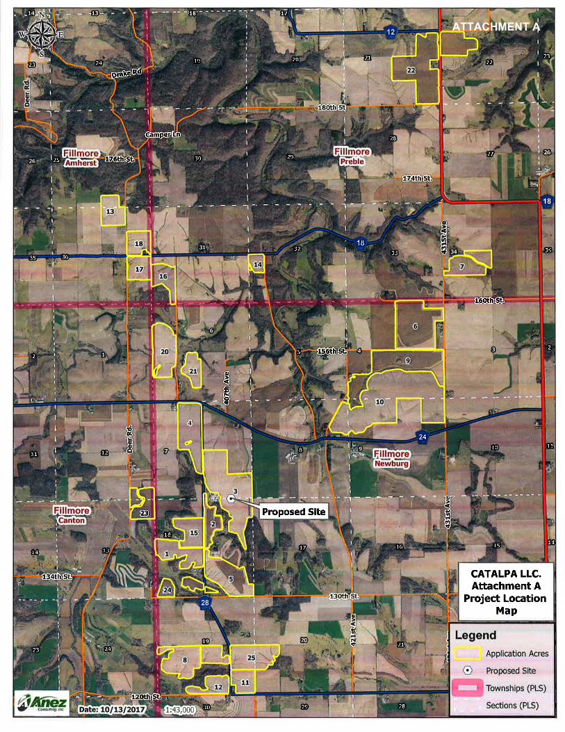
ATTACHMENT A

ATTACHMENT B

111'
138'
1175'
NORTH
PROPERTY
LINE
903'
EAST
PROPERTY
LINE
1235'
1451'
SOUTH
PROPERTY
LINE
445'
1380'
Date
1700 Technology Drive NE
Suite 130
Willmar, MN 56201
(320) 235-1970
Sheet Number
Scale
Project Number
1" = 150'
1 OF 1
3/27/2018
FILLMORE COUNTY, MN.
ATTACHMENT C - SITE PLAN
BRAD HERMAN
CATALPA, LLC.
SEC. 7&18, TWP. 101N , R. 8W
N
S
EWATTACHMENT C

!.
!.
!.
!.
!.
!.
!.
!.
!.
!.
!.
!.
!.
!.
!.
!.
!.
!.
!.
!.
!.
!.
!.
!.
!.
!.
!.
!.
!.
!.
!.
!.
!.
!.
!.
!.
!.
!.
!.
!.
!.
!.
!.
!.
!.
!.
!.
!.
!.
!.
!.
!.
!.
!.
!.
!.
!.
!.
!.
!.
!.
!.
!.
!.
!.
!.
!.
!.
!.
!.
!.
!.
!.
!.
!.
!.
!.
!.
!.
!.
!.
!.
!.
!.
!.
!.
!.
!.
!.
!.!.
!.
!.
!.
!.
!.!.
!.
!.
!.
!.
!.
!.
!.
!.
!.
!.
!.
!.
!.
!.
!.
!.
!.!.
!.
!.
!.
!.
!.
!.
!.
#*
#*
#*
#*
"/
"/"/
"/
"/
"/
"/
"/
"/
"/
"/
"/
"/
"/
"/
"/
"/
"/"/ "/ "/
"/"/
"/
"/ "/"/
"/
"/
"/
"/
7 8
18
17
20
19
Newburg Cre ek
0.95
0.89
0.76
0.71
0.58
0.47
0.31
0.89
0.89
0.95
0.76
6
8 97
5
4
32
28
40
24
25
1516
1214
11
23
27
29
26
31
32
21
22
19
1817
Donaldson Creek
Other rocks
Cambrian-Ordovician aquifer system
FillmoreNewburg
FillmoreCanton
456728
456724
Deer
Rd.
130th St.
421st Ave
407t
h Ave
130th St. CATALPA LLC.ATTACHMENT D
ONE MILE RADIUSSENSITIVE FEATURES MAP
LegendSections (PLS)Townships (PLS)
"/ Residences
!. Public Wells(CWI)!. Private Wells(CWI)
AquifersDWSMA(MDH)Well Head Protection Areas(MDH)
GrassWaterWayKarst Features(MNDNR)
# Stream Sink#* Sinkhole$T Tile OutletN Tile InletÑ MIsc.
Public Watercourses(MNDNR)Public Water WatercoursePublic Ditch/Altered Natural WatercoursePublic Waters Basins(MNDNR)
Streams(NHD)Intermittent Perennial
Water Body(NHD)390 Lake/Pond436 Reservoir466 Swampmarsh
Trout Stream Designation(MNDNR)Designated Trout StreamProtected Tributary to Designated Trout StreamImpaired 2012 Streams(MPCA)1:16,500
µ
Date: 11/27/2017
Proposed Site
One Mile Radius
Units in Miles
ATTACHMENT D

3
10
9
6
8
4
5
22
1
20
25
7
2
22
15
13
1617
18
12 11
23
7
21
14
2424
23
134
6
7 98
5
22
1315
18
10
27
17
2024
30
19
12
31
28
33 34
2925
3236
21
16
1924 20 21 22
22
23
14
11
27
35
26
28
26
35
29
2323
30
11
25
14
23
26 26
FillmoreNewburg
FillmorePreble
FillmoreCanton
FillmoreAmherst
456718
456724
456712
Deer
Rd.
421st Ave
156th St.
134th St.
Drake Rd
407t
h Ave
174th St.
CATALPA LLC. - OVERVIEW MAP
LegendApplication AcresSections (PLS)Townships (PLS)1:42,000
µ
Date: 12/12/2017
ATTACHMENT E

!.
!.
!.
!.
!.
!.
!.
!.
!.
!.
!.
!.
!.
!.
!.
!.
!.
!.
!.
!.
!.
!.
!.
!.
!.
!.
!.
!.!.
!.
#*
#*
#*
21 22
28 27
16 15
22
22
FillmorePreble
"Ç)43
456712
180th St
186th St.
CATALPA LLC. - SENSITIVE FEATURES & LAND APPLICATION SETBACK MAPLegend
Application AcresSections (PLS)Townships (PLS)
!. Public Wells(CWI)!. Private Wells(CWI)
GrassWaterWay
Karst Features(MNDNR)# Stream Sink#* Sinkhole$T Tile OutletN Tile InletÑ MIsc.
Public Watercourses(MNDNR)Public Water WatercoursePublic Ditch/Altered Natural WatercoursePublic Waters Basins(MNDNR)
Streams(NHD)Intermittent Perennial
Water Body(NHD)390 Lake/Pond436 Reservoir466 Swampmarsh
Manure Application Setbacks(MPCA)Grass Waterway: Do not apply withinWetland/Stream: 25ft-No ApplicationWells/Karst: 50ft - No ApplicationWetland/Stream/Karst:300ft inject or incorporate within 24hrs.
Depth To Bedrock(NRCS-WSS)0 - 40 Inches> 40 Inches
1:10,000
µ
Date: 12/12/2017
ATTACHMENT E-1
!.
!.
!.
!.
!.
!.
!.
!.
!.
!.
!.
!.
!.
!.
!.
!.
!.
!.
!.
!.
!.
!.
!.
!.
!.
!.
!.
!.
!.
!.
!.
!.
!.
!.
!.
!.
!.
!.
!.
!.
!.
!.
!.
!.
!.
!.
!.
!.
!.
!.
!.
!.
!.
!.
!.
!.
!.
!.
!.
!.
!.
!.
!.
!.
!.
!.!.
!.
!.
!.
!.
!.
!.
!.
!.
!.
!.
!.
!.
!.
!.
!.
!.
!.
!.
#*
#*
#*
#*
3631
25
1
30
6
13
16
17
18
Wisel Creek
FillmoreAmherst
FillmorePreble
FillmoreCanton
FillmoreNewburg
456718
Deer
Rd.
CATALPA LLC. - SENSITIVE FEATURES & LAND APPLICATION SETBACK MAPLegend
Application AcresSections (PLS)Townships (PLS)
!. Public Wells(CWI)!. Private Wells(CWI)
GrassWaterWay
Karst Features(MNDNR)# Stream Sink#* Sinkhole$T Tile OutletN Tile InletÑ MIsc.
Public Watercourses(MNDNR)Public Water WatercoursePublic Ditch/Altered Natural WatercoursePublic Waters Basins(MNDNR)
Streams(NHD)Intermittent Perennial
Water Body(NHD)390 Lake/Pond436 Reservoir466 Swampmarsh
Manure Application Setbacks(MPCA)Grass Waterway: Do not apply withinWetland/Stream: 25ft-No ApplicationWells/Karst: 50ft - No ApplicationWetland/Stream/Karst:300ft inject or incorporate within 24hrs.
Depth To Bedrock(NRCS-WSS)0 - 40 Inches> 40 Inches
1:10,000
µ
Date: 12/12/2017
ATTACHMENT E-2

!.
!.
!.
!.
!.
!.
!.
!.
!.
!.
!.
!.
!.
!.
!.
!.
!.
!.
!.
!.
!.
!.
!.
!.
!.
!.
!.
!.
!.
!.
#*
14
3231 Wisel C
reek
FillmorePreble 456718
CATALPA LLC. - SENSITIVE FEATURES & LAND APPLICATION SETBACK MAPLegend
Application AcresSections (PLS)Townships (PLS)
!. Public Wells(CWI)!. Private Wells(CWI)
GrassWaterWay
Karst Features(MNDNR)# Stream Sink#* Sinkhole$T Tile OutletN Tile InletÑ MIsc.
Public Watercourses(MNDNR)Public Water WatercoursePublic Ditch/Altered Natural WatercoursePublic Waters Basins(MNDNR)
Streams(NHD)Intermittent Perennial
Water Body(NHD)390 Lake/Pond436 Reservoir466 Swampmarsh
Manure Application Setbacks(MPCA)Grass Waterway: Do not apply withinWetland/Stream: 25ft-No ApplicationWells/Karst: 50ft - No ApplicationWetland/Stream/Karst:300ft inject or incorporate within 24hrs.
Depth To Bedrock(NRCS-WSS)0 - 40 Inches> 40 Inches
1:5,000
µ
Date: 12/12/2017
ATTACHMENT E-3

!.
!.
!.
!.
!.
!.
!.
!.
!.
!.
!.
!.
!.
!.
!.
!.
!.
!.
!.
!.
!.
!.
!.
!.
!.
34
7
7
FillmorePreble
431S
t Ave
CATALPA LLC. - SENSITIVE FEATURES & LAND APPLICATION SETBACK MAPLegend
Application AcresSections (PLS)Townships (PLS)
!. Public Wells(CWI)!. Private Wells(CWI)
GrassWaterWay
Karst Features(MNDNR)# Stream Sink#* Sinkhole$T Tile OutletN Tile InletÑ MIsc.
Public Watercourses(MNDNR)Public Water WatercoursePublic Ditch/Altered Natural WatercoursePublic Waters Basins(MNDNR)
Streams(NHD)Intermittent Perennial
Water Body(NHD)390 Lake/Pond436 Reservoir466 Swampmarsh
Manure Application Setbacks(MPCA)Grass Waterway: Do not apply withinWetland/Stream: 25ft-No ApplicationWells/Karst: 50ft - No ApplicationWetland/Stream/Karst:300ft inject or incorporate within 24hrs.
Depth To Bedrock(NRCS-WSS)0 - 40 Inches> 40 Inches
1:5,000
µ
Date: 12/12/2017
ATTACHMENT E-4

!.
!.
!.
!.
!.
!.
!.
!.
!.
!.
!.
!.
!.
!.
!.
!.
!.
!.
!.
!.
!.
!.
!.
!.
!.
!.
!.
!.
!.
!.
!.
!.
!.
!.
!.
!.
!.
!.
!.
!.
!.
!.
!.
!.
!.
!.
!.
!.!.
!.
!.
!.
!.
!.
!.
!.
!.
!.
!.!.
!.
!.
4
9
10
9
6
Wisel C reek
FillmoreNewburg
FillmorePreble
456724
156th St.
431S
t Ave
421s
t Ave
160th St.
Cedar Valley Rd.
431s
t Ave
CATALPA LLC. - SENSITIVE FEATURES & LAND APPLICATION SETBACK MAPLegend
Application AcresSections (PLS)Townships (PLS)
!. Public Wells(CWI)!. Private Wells(CWI)
GrassWaterWay
Karst Features(MNDNR)# Stream Sink#* Sinkhole$T Tile OutletN Tile InletÑ MIsc.
Public Watercourses(MNDNR)Public Water WatercoursePublic Ditch/Altered Natural WatercoursePublic Waters Basins(MNDNR)
Streams(NHD)Intermittent Perennial
Water Body(NHD)390 Lake/Pond436 Reservoir466 Swampmarsh
Manure Application Setbacks(MPCA)Grass Waterway: Do not apply withinWetland/Stream: 25ft-No ApplicationWells/Karst: 50ft - No ApplicationWetland/Stream/Karst:300ft inject or incorporate within 24hrs.
Depth To Bedrock(NRCS-WSS)0 - 40 Inches> 40 Inches
1:13,000
µ
Date: 12/12/2017
ATTACHMENT E-5

!.
!.
!.
!.
!.
!.
!.
!.
!.
!.
!.
!.
!.
!.
!.
!.
!.
!.
!.
!.
!.
!.
!.
!.
!.
!.
!.
!.
!.
!.
!.
!.
!.
!.
!.
!.
!.
!.
!.
!.
!.
!.
!.
!.
!.
!.
!.
!.
!.
!.
!.
!.
!.
!.!.
!.
!.
!.
!.
!.
!.
!.
!.
!.
!.
!.
!.
!.
!.
!.
!.
!.!.
!.
!.
!.
!.
#*
6
7
1
12
4
20
21
Donaldson Creek
W i sel Creek
Wisel Cree k
FillmoreNewburg
FillmoreCanton 456724
Deer
Rd.
403r
d Ave
407t
h Ave
CATALPA LLC. - SENSITIVE FEATURES & LAND APPLICATION SETBACK MAPLegend
Application AcresSections (PLS)Townships (PLS)
!. Public Wells(CWI)!. Private Wells(CWI)
GrassWaterWay
Karst Features(MNDNR)# Stream Sink#* Sinkhole$T Tile OutletN Tile InletÑ MIsc.
Public Watercourses(MNDNR)Public Water WatercoursePublic Ditch/Altered Natural WatercoursePublic Waters Basins(MNDNR)
Streams(NHD)Intermittent Perennial
Water Body(NHD)390 Lake/Pond436 Reservoir466 Swampmarsh
Manure Application Setbacks(MPCA)Grass Waterway: Do not apply withinWetland/Stream: 25ft-No ApplicationWells/Karst: 50ft - No ApplicationWetland/Stream/Karst:300ft inject or incorporate within 24hrs.
Depth To Bedrock(NRCS-WSS)0 - 40 Inches> 40 Inches
1:13,000
µ
Date: 12/12/2017
ATTACHMENT E-6

!.
!.
!.
!.
!.
!.
!.
!.
!.
!.
!.
!.
!.
!.
!.
!.
!.
!.
!.
!.
!.
!.
!.
!.
!.
!.
!.
!.
!.
!.
!.
!.
!.
!.
!.
!.
!.
!.
!.
!.
!.
!.
!.
!.
!.
!.
!.
!.
!.
!.
!.
!.
!.
!.!.
!.
!.
!.
!.
!.
!.
!.
!.
!.
!.
!.
!.
!.
!.
!.
!.
!.!.
!.
!.
!.
!.
#*
#*
#*
7
18
13
12
3
5
1
2
15
23
2424
23
Donald
so n Creek
FillmoreNewburgFillmore
Canton
456728
Deer
Rd.
130th St.130th St.
CATALPA LLC. - SENSITIVE FEATURES & LAND APPLICATION SETBACK MAPLegend
Application AcresSections (PLS)Townships (PLS)
!. Public Wells(CWI)!. Private Wells(CWI)
GrassWaterWay
Karst Features(MNDNR)# Stream Sink#* Sinkhole$T Tile OutletN Tile InletÑ MIsc.
Public Watercourses(MNDNR)Public Water WatercoursePublic Ditch/Altered Natural WatercoursePublic Waters Basins(MNDNR)
Streams(NHD)Intermittent Perennial
Water Body(NHD)390 Lake/Pond436 Reservoir466 Swampmarsh
Manure Application Setbacks(MPCA)Grass Waterway: Do not apply withinWetland/Stream: 25ft-No ApplicationWells/Karst: 50ft - No ApplicationWetland/Stream/Karst:300ft inject or incorporate within 24hrs.
Depth To Bedrock(NRCS-WSS)0 - 40 Inches> 40 Inches
1:13,900
µ
Date: 12/12/2017
ATTACHMENT E-7

!.
!.
!.
!.
!.
!.
!.
!.
!.
!.
!.
!.
!.
!.
!.
!.
!.
!.
!.
!.
!.
!.
!.
!.
!.
!.
!.
!.
!.
!.
!.
!.
!.
!.
!.
!.
!.
!.
!.
!.
!.
!.
!.
!.
!.
!.
!.
!.
!.
!.
!.
!.
!.
!.
!.
!.
!.
!.
!.
!.
!.
!.
!.
!.
!.
!.
!.
!.
!.
!.
!.
!.
!.!.
!.
!.
!.
19
30
825
1211
FillmoreNewburg
Fillm
ore
Cant
on
456728
120th St.
411t
h Ave
CATALPA LLC. - SENSITIVE FEATURES & LAND APPLICATION SETBACK MAPLegend
Application AcresSections (PLS)Townships (PLS)
!. Public Wells(CWI)!. Private Wells(CWI)
GrassWaterWay
Karst Features(MNDNR)# Stream Sink#* Sinkhole$T Tile OutletN Tile InletÑ MIsc.
Public Watercourses(MNDNR)Public Water WatercoursePublic Ditch/Altered Natural WatercoursePublic Waters Basins(MNDNR)
Streams(NHD)Intermittent Perennial
Water Body(NHD)390 Lake/Pond436 Reservoir466 Swampmarsh
Manure Application Setbacks(MPCA)Grass Waterway: Do not apply withinWetland/Stream: 25ft-No ApplicationWells/Karst: 50ft - No ApplicationWetland/Stream/Karst:300ft inject or incorporate within 24hrs.
Depth To Bedrock(NRCS-WSS)0 - 40 Inches> 40 Inches
1:11,000
µ
Date: 12/12/2017
ATTACHMENT E-8

!.
!.
!.
!.
!.
!.
!.
!.
!.
!.
!.
!.
!.
!.
!.
!.
!.
!.
!.
!.
!.
!.
!.
!.
!.
!.
!.
!.
!.
!.
!.
!.
!.
!.
!.
!.
!.
!.
!.
!.
!.
!.
!.
!.
!.
!.
!.
!.
!.
!.
!.
!.
!.
!.
!.
!.
!.
!.
!.
!.
!.
!.
!.
!.
!.
!.
!.
!.
!.
!.
!.
!.
!.
!.
!.
!.
!.
!.
!.
!.
!.
!.
!.
!.
!.
!.
!.
!.
!.
!.
!.
!.
!.
!.
!.
!.
!.
!.!.
!.
!.
!.
!.
!.
!.
!.
!.
!.
!.
!.
!.
!.
!.
!.
!.
!.
!.
!.
!.
!.
!.
!.
!.
!.
!.
!.
!.
!.
!.
!.
!.
!.
!.
!.
!.
!.
!.
!.
!.
!.
!.
!.!.
!.
!.
!.!.!.
!.
!.
!.
!.
!.!.!.
!.
!.
!.
!.
!.
!.
!.
!.
!.
!.
!.
!.
!.
!.
!.
!. !.
!.
!.
!.
!.
!.
!.
!.
!.
!.
!.
#*
#*#*
#*
#*
#*
#*
#*#*
#*#*#*#*#*
#*#*#*
#*
#*#*
#*#*#*#*
#*
#*
#*
#*#*
#*
#*#*#*#*#*#*#*#*
#* #*#*
#*#*
#*
#*#*#*
#*#*#*#*
#*
#*
#*
#*#*
#*
Ñ
kh
Cambrian-Ordovician aquifer system
3
46
7 98
51
22
2
15
18
10
27
17
20
30
19
31
28
33
34
29
32
21
16
19 20 21 22
24
13
12
36
26
25
35
11
14
23
2423
272829 263025
Other rocks
3
10
9
6
8
4
5
22
1
20
25
7
2
22
15
13
1617
18
12 11
23
7
21
14
2424
23
Wisel Creek
Unnamed Creek
Chickentown Creek
Root River, South Fork
Vesta Creek
Unnamed Creek
Unnamed Creek
Unnamed Creek
Unnamed Creek
Unnamed
Creek Unnamed Creek
Unnamed Creek
Unnamed Creek
R J D Memorial Hardwood
Wisel Creek AMA (Fillmore)
So. Fork Root River AMA (Fillmore)
Wisel Creek
Donaldson Creek
FillmoreNewburg
FillmorePreble
Fillm
ore
Cant
onFil
lmor
eAm
herst
456718
456724
456712
Deer
Rd.
421st Ave
156th St.
Arro
whea
d Rd
407t
h Ave
174th St.
CATALPA LLC. ATTACHMENT E
CUMULATIVE IMPACTS MAPLegend
Application AcresSections (PLS)Townships (PLS)
!. Public Wells(CWI)!. Private Wells(CWI)
GrassWaterWayAquifersDWSMA(MDH)WHPA(MDH)
Karst Features(MNDNR)# Stream Sink#* Sinkhole
$T Tile OutletN Tile InletÑ MIsc.
Depth To Bedrock(NRCS-WSS)0 - 40 Inches> 40 Inches
MNDNR Mgmt AreasAquatic Management AreaState ForestWildlife Management Area
Public Watercourses(MNDNR)Public Water WatercoursePublic Ditch/Altered Natural WatercoursePublic Waters Basins(MNDNR)
Streams(NHD)Intermittent Perennial
Water Body(NHD)390 Lake/Pond436 Reservoir466 Swampmarsh
Trout Stream Designation(MNDNR)Designated Trout StreamProtected Tributary to Designated Trout StreamImpaired 2012 Streams(MPCA)1:41,000
µ
Date: 3/29/2018
Proposed Site
AquiferBoundary
ATTACHMENT F
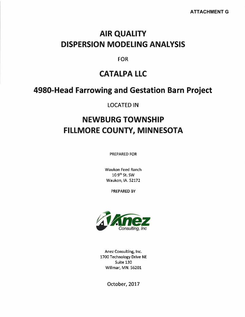
ATTACHMENT G


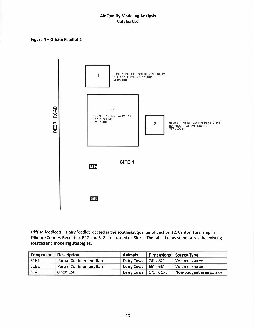


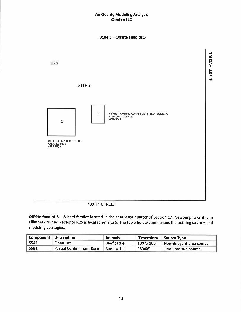


ATTACHMENT H


ATTACHMENT I


ATTACHMENT J


ATTACHMENT K