Embed Size (px)
Citation preview
Bol. Mus. Int. de Roraima V. 7(2): 45 - 54. 2013
Barbosa et. al.
Notes on an exploratory expedition to the headwaters of the Mau
(Ireng) river, Northern Brazilian Amazon*
Reinaldo Imbrozio Barbosa1, Sebastião Pereira do Nascimento1, Ari Alfredo
Weiduschat2, Fábio Bonatto3
1. INPA - Instituto Nacional de Pesquisas da Amazônia, Núcleo de Roraima. Rua Coronel Pinto 315 – Centro. 69301-
150 Boa Vista - Roraima. E-mail para contato: [email protected].
2. IBAMA - Instituto Brasileiro do Meio Ambiente e dos Recursos Naturais Renováveis, Superintendência de
Roraima. Avenida Brigadeiro Eduardo Gomes 4358 - Jardim Floresta. 69304-650 Boa Vista - Roraima.
3. COPEL - Companhia Paranaense de Energia, DBIO - Departamento de Biodiversidade. Rua Com. Araújo 614 -
Mezanino, Batel. 80420-170 Curitiba - Paraná.
*Tradução revisada e atualizada do texto Barbosa, R.I.; Nascimento, S.P.; Weiduschat, A.A.; Bonatto, F. 2000. Notas
de uma expedição às nascentes do rio Mau (Ireng), Roraima, Brasil. Manaus, MCT/INPA. Série Documentos 7. 28 p.
RESUMO
Notas sobre uma expedição exploratória às nascentes do rio Mau (Ireng), norte da Amazônia Brasileira. Este trabalho
resume os resultados de uma expedição exploratória realizada às nascentes do rio Mau (Ireng) entre 21 e 28 de janeiro de 1996.
Esta região marca a fronteira entre Brasil e Guiana situada no extremo norte da Amazônia brasileira. Nosso objetivo foi observar o
ambiente, populações humanas, fauna e flora, verificando informações históricas e coletando material biológico desta região
fronteiriça da Amazônia que abrange parte do Parque Nacional do Monte Roraima e da Terra Indígena Raposa – Serra do Sol,
Roraima, Brasil. A acumulação de informação sobre esta região da Amazônia providencia melhor base de conhecimento que pode
ser aplicado em atividades de conservação e uso sustentado dos recursos naturais.
PALAVRAS-CHAVE: Fronteira Internacional, Unidades de Conservação, Terra Indígena, Recursos Naturais.
ABSTRACT
Notes on an exploratory expedition to the headwaters of the Mau (Ireng) river, Northern Brazilian Amazon. This work
summarizes the results of an exploratory expedition to the headwaters of the Mau (Ireng) River made between the 21st and 28th of
January 1996. This region marks the frontier between Brazil and Guyana in the north Brazilian Amazon. Our aim was to observe
the environment, human populations, fauna and flora, verifying historical information and collecting biological material from this
Amazon frontier region which includes part of the Monte Roraima National Park and Raposa - Serra do Sol Indian Land, in the
State of Roraima, Brazil. Information from this Amazon region provides a better knowledge basis that can be applied in
conservation activities and sustainable use of natural resources.
KEYWORDS: International Border, Protected Areas, Indian Lands, Natural Resources.
INTRODUCTION
The purpose of this document is to present some observations and considerations of an exploratory expedition to the headwaters of the Mau (or Ireng) River, northern Brazilian Amazon, made between the 21st and 28th of January 1996. Our aim was to observe the environment, human populations, fauna and flora, verifying historical information and collecting biological material from this Amazon frontier region which includes part of the Monte Roraima National Park and Raposa - Serra do Sol Indian Land, in the State of Roraima, Brazil (Figure 1). This part of the Amazon region is still relatively unknown because of the difficulty of access. Geographical description
and surveys of the landscape potentialities should provide better local knowledge that can be applied in conservation activities and sustainable use of natural resources.
The two names given to the same river are derived from local indigenous languages: Ireng being adopted by the Guyanese side while Mau (Maú, Mahú, Máho) by Brazilian side of the region. On the other hand, Schomburgk (1840, p. 192) explain that “The Wapisianas and Atorais, who inhabit the Takutu, call it Butuau-uru. The Macusis name the Mahu Ireng”. The set of historical documents about frontier demarcation not present the reasons for the distinction between the terms (cf. Nabuco 1903). Some local reports indicate that Ireng is derived from a place named as Ireng-Mutã
Recebido em: 19/06/2013 Aceito em: 08/09/2013.
Bol. Mus. Int. de Roraima V. 7(2): 45 - 54. 2013
46
Barbosa et. al.
(today Uiramutã), or even that this term is an indigenous word meaning river (suggesting Mahu = Mehru = Fall and Ireng = River; Falls River). However, there is no really convincing explanation for adoption of distinct terms to the same river.
The Mau river basin drains a great part of the frontier between Brazil and Guyana. Its main tributaries are the Uialan and Canã rivers on the Brazilian side and the Cacó, Dacã and Socobi rivers on the Guyanese side. All of these drain into the upper and middle reaches of the Mau and flow over very ancient terrain formed by tectonic structures and Protozoic sedimentary rocks belonging to the Roraima Supergroup (Guyana Shield). The waters of the Mau have a dark coloration as a typical Amazonian black-water river. In the region under observation, the river runs through valleys between mountain ranges which vary in altitude from 600 to 1,200 meters above sea-level (m).
The starting point for our expedition was the Indian Village of Orinduik (04o 45' 31" N and 60o 01' 59" W). Inhabited by Macuxi Indians, it is situated on the banks of the river within the indigenous area Raposa - Serra do Sol.
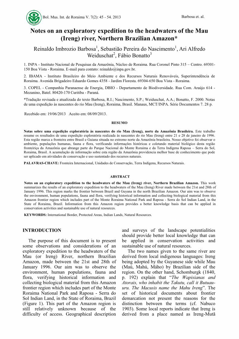
Recently, the Brazilian Supreme Court sanctioned this area in favor of the local indigenous peoples (Lauriola 2013). This spot is near the Orinduik Falls (580 m a.s.l.) which we considered as marking the beginning of the upper course of the Mau (Figure 2). From here on it was necessary to go upstream by boat for a day and a half passing over 18 rapids.
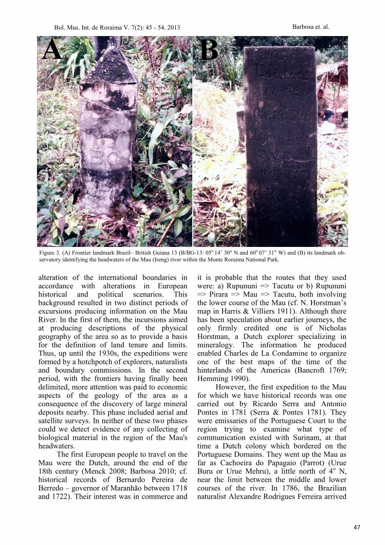
This stage ended at the frontier landmark Brazil-5 (B-5: 05o 04' 11" N and 59o 58' 47" W), at the confluence of the Mau and the Socobi rivers at an altitude of about 650 m. The B-5 landmark is near the Cachoeira do Grande Caracol or Great Snail Falls (Kurutuwu Mehru or Kurutuik Falls), a waterfall in two stages with a total drop of about 100 m. From here on it was two days walking through dense mountain forest to the Brazil-British Guiana frontier landmark 13 (B/BG-13: 05o 14’ 30" N, 60o 07’ 31" W) in the Pacaraima Range near the northernmost point of the Uialan Mountain, at an altitude of 1,120 m. This landmark is the third most northerly geographical mark in Brazil and identifies the headwaters of the Mau (Ireng) river within the Monte Roraima National Park (Figure 3). It is about 10 km from Mount Caburaí, Brazil's northernmost point (B/BG-11A); 05º 17’ 19,77" N, 60º 11’ 54,51" W (Reis 2009).
HISTORICAL BACKGROUND Up until the beginning of the 20th
century, the whole of the Mau Basin was the subject of an ancient territorial dispute between Brazil and Great Britain in the form of its colony British Guiana (Nabuco 1903; Farage 1991; Barbosa 1994). The great expansionist projects of the European powers and difficult access to the region resulted in constant
Figure 1. Geographical location of the Mau (Ireng) river
basin, Northern Brazilian Amazon.
Figure 2. Orinduik Falls, middle course of the Mau (Ireng)
river.
Bol. Mus. Int. de Roraima V. 7(2): 45 - 54. 2013
47
Barbosa et. al.
alteration of the international boundaries in accordance with alterations in European historical and political scenarios. This background resulted in two distinct periods of excursions producing information on the Mau River. In the first of them, the incursions aimed at producing descriptions of the physical geography of the area so as to provide a basis for the definition of land tenure and limits. Thus, up until the 1930s, the expeditions were formed by a hotchpotch of explorers, naturalists and boundary commissions. In the second period, with the frontiers having finally been delimited, more attention was paid to economic aspects of the geology of the area as a consequence of the discovery of large mineral deposits nearby. This phase included aerial and satellite surveys. In neither of these two phases could we detect evidence of any collecting of biological material in the region of the Mau's headwaters.
The first European people to travel on the Mau were the Dutch, around the end of the 18th century (Menck 2008; Barbosa 2010; cf. historical records of Bernardo Pereira de Berredo – governor of Maranhão between 1718 and 1722). Their interest was in commerce and
it is probable that the routes that they used were: a) Rupununi => Tacutu or b) Rupununi => Pirara => Mau => Tacutu, both involving the lower course of the Mau (cf. N. Horstman’s map in Harris & Villiers 1911). Although there has been speculation about earlier journeys, the only firmly credited one is of Nicholas Horstman, a Dutch explorer specializing in mineralogy. The information he produced enabled Charles de La Condamine to organize one of the best maps of the time of the hinterlands of the Americas (Bancroft 1769; Hemming 1990).
However, the first expedition to the Mau for which we have historical records was one carried out by Ricardo Serra and Antonio Pontes in 1781 (Serra & Pontes 1781). They were emissaries of the Portuguese Court to the region trying to examine what type of communication existed with Surinam, at that time a Dutch colony which bordered on the Portuguese Domains. They went up the Mau as far as Cachoeira do Papagaio (Parrot) (Urue Buru or Urue Mehru), a little north of 4o N, near the limit between the middle and lower courses of the river. In 1786, the Brazilian naturalist Alexandre Rodrigues Ferreira arrived
Figure 3. (A) Frontier landmark Brazil– British Guiana 13 (B/BG-13: 05o 14’ 30" N and 60o 07’ 31" W) and (B) its landmark ob-
servatory identifying the headwaters of the Mau (Ireng) river within the Monte Roraima National Park.
Bol. Mus. Int. de Roraima V. 7(2): 45 - 54. 2013
48
Barbosa et. al.
at the mouth of the river and went up as far as Pirara Creek (lower Mau). Ferreira's aim was to report on the situation on the frontiers with colonies of other European powers (England and Netherlands) and to appraise the economic potential of the Rio Branco basin (Amoroso & Farage 1994). In 1787, Colonel Manuel da Gama Lobo D'Almada described the valley of the Rio Branco and touched briefly on the lower Mau region (D'Almada 1787). In 1798, the standard bearer Francisco Barata, Portuguese emissary to Surinam, commented on the connection between the Mau and Rupununi basins by way of the Pirara Creek (Barata 1846) reaching the same conclusion that Serra & Pontes and D'Almada had come to some years before. In 1838 and 1839, Robert Schomburgk, a German in the service of the British Crown, detailed geographical and botanical aspects of the lower Mau around the mouth of the Pirara Creek and of the Unamara Creek, this last being near the town of Normandia in the State of Roraima today (Schomburgk 1840). Koch-Grünberg also made ethnological studies near the confluence of the Mau and the Tacutu in his travel between 1911-1913 (Koch-Grünberg 1979). In 1915, an English couple, the Clementis, interested in getting to Mount Roraima, left Georgetown, reached the Potaro River and crossed the middle course of the Mau near Maturuca Mountain (Clementi 1916). However, they made no relevant observations.
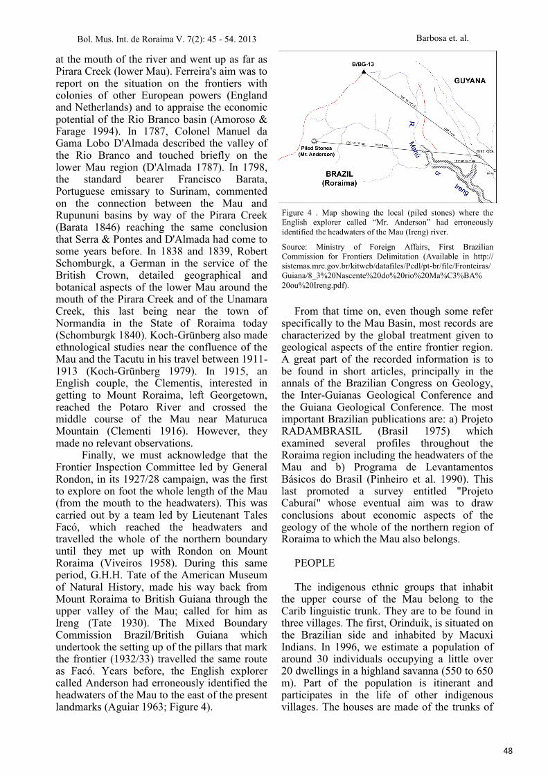
Finally, we must acknowledge that the Frontier Inspection Committee led by General Rondon, in its 1927/28 campaign, was the first to explore on foot the whole length of the Mau (from the mouth to the headwaters). This was carried out by a team led by Lieutenant Tales Facó, which reached the headwaters and travelled the whole of the northern boundary until they met up with Rondon on Mount Roraima (Viveiros 1958). During this same period, G.H.H. Tate of the American Museum of Natural History, made his way back from Mount Roraima to British Guiana through the upper valley of the Mau; called for him as Ireng (Tate 1930). The Mixed Boundary Commission Brazil/British Guiana which undertook the setting up of the pillars that mark the frontier (1932/33) travelled the same route as Facó. Years before, the English explorer called Anderson had erroneously identified the headwaters of the Mau to the east of the present landmarks (Aguiar 1963; Figure 4).
From that time on, even though some refer specifically to the Mau Basin, most records are characterized by the global treatment given to geological aspects of the entire frontier region. A great part of the recorded information is to be found in short articles, principally in the annals of the Brazilian Congress on Geology, the Inter-Guianas Geological Conference and the Guiana Geological Conference. The most important Brazilian publications are: a) Projeto RADAMBRASIL (Brasil 1975) which examined several profiles throughout the Roraima region including the headwaters of the Mau and b) Programa de Levantamentos Básicos do Brasil (Pinheiro et al. 1990). This last promoted a survey entitled "Projeto Caburaí" whose eventual aim was to draw conclusions about economic aspects of the geology of the whole of the northern region of Roraima to which the Mau also belongs.
PEOPLE The indigenous ethnic groups that inhabit
the upper course of the Mau belong to the Carib linguistic trunk. They are to be found in three villages. The first, Orinduik, is situated on the Brazilian side and inhabited by Macuxi Indians. In 1996, we estimate a population of around 30 individuals occupying a little over 20 dwellings in a highland savanna (550 to 650 m). Part of the population is itinerant and participates in the life of other indigenous villages. The houses are made of the trunks of
Figure 4 . Map showing the local (piled stones) where the
English explorer called “Mr. Anderson” had erroneously
identified the headwaters of the Mau (Ireng) river.
Source: Ministry of Foreign Affairs, First Brazilian
Commission for Frontiers Delimitation (Available in http://
sistemas.mre.gov.br/kitweb/datafiles/Pcdl/pt-br/file/Fronteiras/
Guiana/8_3%20Nascente%20do%20rio%20Ma%C3%BA%
20ou%20Ireng.pdf).
Bol. Mus. Int. de Roraima V. 7(2): 45 - 54. 2013
49
Barbosa et. al.
saplings (young trees) plastered with a mixture of clay and sand. Most of them are thatched with palm leaves Mauritia flexuosa L.f. (moriche palm). The main activity is subsistence farming carried out on forested hillsides or in the small patches of gallery forest that accompany the Mau. The community makes use of game and fish as alternative sources of animal protein. The religion practiced is strongly influenced by the Catholic Church but still retains traces of original cultural rites.
A little above Orinduik and as far as the boundary mark B-5, the banks of the river are inhabited by small groups of Patamona Indians belonging to the villages of Waipa and Kaibarapai (or Canauapai). The centers of these villages are on the Guyana side, set among low forested mountains (600 to 900 m). The economy of the two villages is based on subsistence farming carried out in clearings along the river's edge and in dry-land (or terra-firme) areas nearer to the village. As a complementary source of animal protein, game seems to be more important than fish due to the small quantity of fish to be found in the Mau. Waipa is Catholic and is situated about three hours north of the Macuxi in Orinduik. They have a state-run educational system and most of the houses are made of boards produced by the community itself. Kaibarapai is five hours upstream from Waipa and is very similar to its neighbors as far as survival strategy is concerned. However, their religious practices were described for us as "Halleluiah", a spiritualist sect that mixes English Protestantism with indigenous ritual (Andrello 1993; Abreu 2010). Im Thurn (1885) identified this religious manifestation among Macuxi and Patamona Indians on the Potaro and Mazaruni rivers (British Guiana) north of the head of the Mau, in 1884. Lieutenant Facó recorded the existence of this ritual among the Mau's inhabitants in 1927/28 (Andrello 1993).
In 1988, this region was the subject of study of an interministerial working group set up by the Brazilian Government. The aim of this group was to define the Raposa - Serra do Sol Indigenous Area. On this occasion, the Kaibarapai village was recorded as being established on the Brazilian side and composed of about 50 individuals. This number agrees
with that given by Ricardo (1995) as the population of Patamona in Roraima. According to the same source, there were about 5,500 individuals of this ethnic group in Guyana. The Indians told us that the village center was transferred to the Guyanese side in 1989 and that the number of people living on the Brazilian side continued to be about the same. The Tuchaua (chief) himself, leader of this village, lived on the Brazilian side. Difficulty of access and transport continues to keep them relatively isolated from other social groups.
ENVIRONMENT AND FLORA In the stretch that was visited, there were
several falls. However, the only one that can really be considered as a true waterfall is the Grande Caracol Falls (Great Snail Falls or Kurutuwu Mehru). The others are typically strong rapids formed by alterations in the level of the land. When the water level is low, it is possible to identify a kind of hard, rosy sandstone. This is a notable feature of the Mau as far as a few kilometers above the Grande Caracol Falls from whence, up as far as the headwaters, the stony bed of the river is covered by a thick layer of sand. According to the Pinheiro et al. (1990), this subregion of the Roraima Super-group is classified as the Uailan Geological Formation and the terrain is chiefly rock.
The vegetation in the proximity of Orinduik and on the upper Mau, is a transition between savanna and dense mountain forest. The savanna (or lavrado as it is called in Brazilian side), is a continuation of the Surumu Volcanic Formation which stretches along an east-west line separating the Boa Vista Formation (low altitude savanna) from the Roraima Super-group. It is characterized as occupying very uneven terrain with several quartz and laterite incrustations and colonized by arboreal species such as the sandpaper tree (Curatela americana L.; Dilleniaceae) and the mirixi (Byrsonima crassifolia (L.) Kunth; Malpighiaceae)I. It is also colonized by creeping species like Bulbostylis spp. (Cyperaceae) and the grasses Andropogon spp. and Trachypogon spp. The latter occupy most of the extent of the Roraima’s savanna (Miranda & Absy 1997; 2000). Another
I There is an interesting comment about these two species in Schomburgk (1840, p. 196): “A march across a savannah is at all times
monotonous; and we had nothing to vary it but stunted trees and bushes. The first consist chiefly of Curatella americana, the latter
of Malphigae”.
Bol. Mus. Int. de Roraima V. 7(2): 45 - 54. 2013
50
Barbosa et. al.
notable aspect is the constant presence of fire in the vegetation. Fire is a cultural tradition of the local Indians who believe that it improves the native pasture for the cattle herds and chases off noxious animals. The use of fire by indigenous peoples in this region was historically documented by Schomburgk (1840).
The forest becomes continuous about 10 km upstream from Orinduik, a little before the village of Waipa. From this point, passing through Kaibarapai village and as far the Grande Caracol Falls, the forest reminds one of those to be found in igapós. However, the water level marks on the trees suggest rapid flooding and not the accumulation of water for months on end as in Central Amazonia. On this stretch, apart the area subject to flooding, the dominant forest type is a sub-type of dense mountain forest with altitudes of 600-900 m. Arboreal species of the families Lecithydaceae (Couroupita guianensis Aubl.), Sapotaceae (Pouteria spp.) and Vochysiaceae (Vochysia sp. and Qualea sp) are common in this region of the river and reach heights of 25-30 m. Legume species are also of frequent occurrence in this area.
Once beyond the Grande Caracol Falls, the landscape of the river basin is one of a chain of high profiles covered by continuous forest right up to the headwaters. In this stretch, the main species observed was Micrandra sp. (Euphorbiaceae), visibly dominant in the forest. Other common species were Clusia grandiflora Splitg. (Clusiaceae), Qualea sp. (Vochysiaceae), Pouteria spp. (Sapotaceae), and Heterostemon sp. (Fabaceae). In the understory the main species observed were Psychotria poeppigiana Müll. Arg. (Rubiaceae) and Siphocampylus sp. (Campanulaceae). Another species of Psychotria with yellow-colored flowers was also common. Similarly, Araceae, Orchidaceae and Bromeliaceae were much in evidence in the understory. These groups of plants were also observed by Silva et al. (2006) in a scientific excursion carried out in 2000 to the Mount Caburaí (Brazil's northernmost; about 10 km from headwaters of the Mau river): > 60 species of Orchidaceae, 6 of Araceae and 6 of Bromeliaceae. According to Silva et al. (2006), the botanical material of this excursion was deposited in the Integrated Museum of Roraima (MIRR; Boa Vista -
Roraima) and National Institute for Research in Amazonia (INPA; Manaus - Amazonas)II. Above the Grande Caracol Falls, the soil is predominantly formed by a mosaic of patches of sandstone and podzols (quartz sands). Being extremely porous, it forces the roots of the plants themselves to be responsible for the rapid recycling of nutrients within this system. They carry out the mechanical fragmentation and direct absorption of organic material deposited on the ground. The roots form a great web over the soil. An exception to this pattern is to be found near the falls in the vicinity of the headwaters, where a mosaic of rocky outcrops and yellow podzols can be seen.
The dark waters of the Mau hydrographic system show great similarity to those of the drainage system of the upper Rio Negro. It is a typical Amazonian black-water river. Both spring from very ancient geological formations and drain soils that are very porous and covered by a moist forest. This characteristic together with the frequency and intensity of rainfall, causes part of the organic material not yet totally decomposed (humic and fulvic acids) to run out of the fluvial micro-systems and into the more voluminous river courses making their waters take on a dark color.
We did not make meteorological records but throughout almost the whole period of our excursion, the rain was incessant especially as we neared the headwaters. The inhabitants of the forest region told us that the weather is normally humid but that there is a dry phase between December and March. The period of heaviest rainfall is between May and July. As far as we could find out, in the savannah region (Orinduik), the months that mark the peaks of the rainy and dry seasons are similar to those of the forest zone. The difference lies in the total annual rainfall. The only meteorological records we found were those of the Mixed Boundary Commission for the year 1932 (Aguiar 1963). Its notes were as follows: a) Forest Zone - Hot humid climate with temperatures varying between 17o C and 25o C during the day and between 11o C and 17o C during the night; b) Savanna Region - Hot dry climate during the day with temperatures varying between 20o C and 28o C and cool at night due to the strong winds which make the temperature fall to between 14o C and 20oC.
II In 1998 an expedition to the Mount Caburaí was conducted jointly by the Brazilian Army, IBAMA, EMBRAPA, MIRR, UFRR
and other federal/state agencies. However, we have no knowledge of publications or where the botanical material was deposited.
Bol. Mus. Int. de Roraima V. 7(2): 45 - 54. 2013
51
Barbosa et. al.
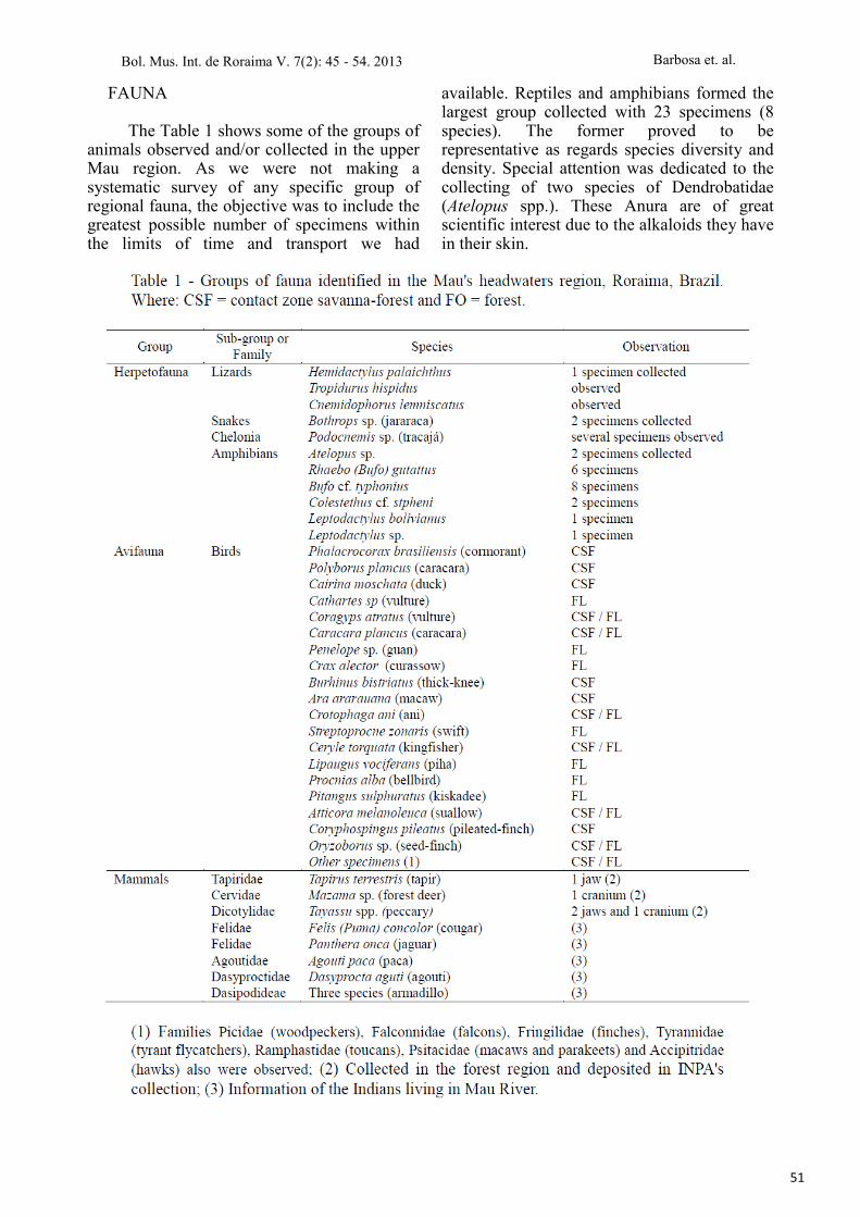
FAUNA The Table 1 shows some of the groups of
animals observed and/or collected in the upper Mau region. As we were not making a systematic survey of any specific group of regional fauna, the objective was to include the greatest possible number of specimens within the limits of time and transport we had
available. Reptiles and amphibians formed the largest group collected with 23 specimens (8 species). The former proved to be representative as regards species diversity and density. Special attention was dedicated to the collecting of two species of Dendrobatidae (Atelopus spp.). These Anura are of great scientific interest due to the alkaloids they have in their skin.
Bol. Mus. Int. de Roraima V. 7(2): 45 - 54. 2013
52
Barbosa et. al.
We were unable to observe any lizards in the forest areas. However, in the open country near Orinduik, it was possible to collect a specimen of Hemidactylus palaichthus (Kluge, 1969) and to observe Tropidurus hispidus (Spix, 1825) and Cnemidophorus lemniscatus (Linnaeus, 1758). Snakes were also found infrequently. Only two specimens of Bothrops sp. (jararaca) in the forest region above the Grande Caracol Falls were found. This same genus of snake was also found by Silva et al. (2006) in a scientific excursion to the Mount Caburaí. It indicates to be very common in this region. Among the Chelonia, we found only one aquatic turtle (Podocnemis sp.) between Orinduik and Socobi. The ichthyofauna is very poor. We collected only a type of electric fish (Gymnotus caropo Linnaeus, 1758) and observed a Mandí (Pimelodidae) and also a Jijú or Yarrow (Characidae). All three form part of the local indigenous diet (personal observation).
The number of birds seen was certainly laughable when compared to the region's apparent potential (cf. Roraima’s bird list in Naka et al. 2006; 2010). Apart from the constant rain which kept many birds away, the lack of a bird specialist in the group hindered better identification. We were only able to describe 18 species with certainty and these chiefly along the course of the river. Others were considered dubious. As for large mammals, we collected five parts of skulls (3 species) in Indians' homes on the edge of the Mau all of which have been deposited in the INPA collection. Apart from these examples, we correlated information on other mammals given by the inhabitants of the region.
The entomofauna of the forest region was represented mainly by: a) ant species - Camponotus cf. abdominalis (solitary), Odontomachus cf. hastatus (solitary) and Eciton drepanophorum (army ants); b) arboreal termites - Nasutitermes cf. corniger and c) beetles - Nilio sp. (Tenebrionidae) and Agra sp. (Carabidae). That of the transition region (savanna/forest) was represented mainly by: a) flies - Simulium sp. (pium or kaboura fly); b) soil termites - Syntermes sp. and Nasutitermes spp. and c) ants - Atta spp. The flea Sarcopsylla penetrans (bicho-de-pé or chigger flea) and Diptera of the Lutzomyia genus (leishmania) were observed in both systems.
Faunal material collected was deposited in the Instituto Nacional de Pesquisas da
Amazônia - INPA (National Institute for Research in Amazonia) in Manaus (herpetofauna, fish, insects and mammals), Museu Integrado de Roraima (Integrated Museum of Roraima) in Boa Vista (herpetofauna) and Museu de Zoologia of the University of São Paulo, São Paulo (herpetofauna).
FINAL CONSIDERATION The headwater of the Mau (Ireng) River
forms part of an Amazon region still relatively unknown because of the difficulty of access. Description of the Indians activities and surveys of the landscape potentialities should permit a better understanding of the relationships between environment and man. It should also help in the decision-making involved in property and land use of the Brazilian side of the region, in an effort to avoid conflicts. On the other hand, after recent Brazilian judicial decision on the ratification of the Raposa - Serra do Sol Indian Land (Brazilian Supreme Court, March 19 - 2009), all local indigenous people living in Brazilian side of this region are expanding efforts in sustainable land use activities involving their natural resources. This approach to development is important and requires the support of international agencies to fund sustainable uses. However, it is also require specific training to the indigenous communities in order to strengthen the capacity to land-use management and the recognition of the economic potential of its natural resources. On these arguments, we hope that this document can be part of a regional database linking sustainable development with nature conservation without land tenure conflicts.
ACKNOWLEDGMENTS The Macuxi Indians from Orinduik
village and the Patamona from Waipa and Kaibarapai received us and permitted our stayed in their land. C. Morato and G. Moreira (herpetofauna), I. P. Miranda and M. T. Campos (botany), S. Wilson (birds), A. Harada (ants), C. Martius (termites), J. Alves-Gomes (gymnotiformes), M. Silva (mammals) and M. Graça (beetles), helped in the identification of the material collected.
Bol. Mus. Int. de Roraima V. 7(2): 45 - 54. 2013
53
Barbosa et. al.
REFERENCES Abreu, S.A. 2010. Os Ingarikó no Aleluia. In: Barbosa,
R.I. & Melo, V.F. (org.), Roraima: Homem, Ambiente
e Ecologia. INPA/UFRR/FEMACT, Boa Vista, p.
109-129.
Aguiar, B.D. 1963 (1940). Trabalhos da Comissão
Brasileira Demarcadora de Limites - Primeira
Divisão - Nas Fronteiras da Venezuela e Guiana
Britânica e Neerlandeza, de 1930 a 1940. In:
Separata dos Anais do 9o Congresso Brasileiro de
Geografia (1940), Rio de Janeiro, p. 203-375.
Amoroso, M.R. & Farage, N. 1994. Relatos da fronteira
amazônica no século XVIII: documentos de Henrique
João Wilckens e Alexandre Rodrigues Ferreira.
NHII/USP & FAPESP, São Paulo, 134 p.
Andrello, G. 1993. Rumo norte: migrações e profetismo
Taurepáng no século XX. In: Diniz, E.; Lopes, J.S.L.
& Prandi, R. (org.). Ciências Sociais Hoje, 1993:
Políticas Públicas, Territórios e Populações
Indígenas. HUCITEC/ANPOCS, São Paulo, p. 244-
265.
Bancroft, E. 1769. An essay on the natural history of
Guiana in South America. T. Becket & P. A. de
Hondt, London. 402 p.
Barata, F.J.R. 1846 (1798). Diário da viagem a Colônia
Holandeza de Surinam, feita pelo porta-bandeira da
sétima companhia do regimento da cidade do Pará,
pelos sertões e rios d'este Estado, em diligencia do
Real Serviço. Revista Trimestral do Instituto
Histórico e Geográfico do Brasil 8: 1-53.
Barbosa, R.I. 1993. Ocupação em Roraima. I. Do
histórico colonial ao início do assentamento dirigido.
Boletim do Museu Paraense Emílio Goeldi (série
antropologia) 9(1): 123-144.
Barbosa, R.I. 2010. Expedições naturalistas e
exploratórias na construção histórica do Vale do Rio
Branco. Mens Agitat 5(1-2): 157-164.
Brasil 1975. Projeto RADAMBRASIL - Levantamento
de Recursos Naturais (Volume 8). Ministério das
Minas e Energia/Departamento Nacional da Produção
Mineral, Rio de Janeiro, 426 p.
Clementi, C. 1916. A journey to the summit of Mount
Roraima. The Geographical Journal 68: 456-473.
D'Almada, M.G.L. 1861 (1787). Descripção relativa ao
Rio Branco e seu território. Revista Trimestral do
Instituto Histórico e Geográfico do Brasil 24(4): 617-
683.
Farage, N. 1991. As muralhas dos sertões: os povos
indígenas no Rio Branco e a colonização. Paz &
Terra/ANPOCS, Rio de Janeiro, 197p.
Harris, C.A. & Villiers, J.A.J. 1911. The expedition
undertaken by Nicolas Horstman at the instance of
Laurens Storm van’s Gravesande in 1739 (Additional
Notes to Introduction). In: Storm van’s Gravesande:
the rise of Britsh Guiana. Hakluyt Society, London,
p. 167-174.
Hemming, J. 1990. How Brazil acquired Roraima.
Hispanic American Historical Review 70(2): 295-
325.
Im Thurn, E.F. 1885. The ascent of Mount Roraima.
Proceedings of the Royal Geographic Society 7: 497-
521.
Koch-Grünberg, T. 1979 (1911-1913). Del Roraima al
Orinoco. Ediciones del Banco Central de Venezuela,
Caracas (Tomos I, II, III).
Lauriola, E. 2013. Indigenous lands, commons, juridical
pluralism and sustainability in Brazil: lessons from
the indigenous lands of Raposa Serra do Sol. Journal
of Latin American Geography 12 (1): 157-185.
Menck, J.T.M. 2008. Ocupação territorial de Roraima.
Cadernos ASLEGIS 34: 133-151.
Miranda, I.S. & Absy, M.L. 1997. A flora fanerogâmica
das savanas de Roraima. In: Barbosa, R.I.; Ferreira,
E.J.G. & Castellón, E.G. (Eds.). Homem, Ambiente e
Ecologia no Estado de Roraima. INPA, Manaus, p.
445-462.
Miranda, I.S. & Absy, M.L. 2000. Fisionomia das
savanas de Roraima. Acta Amazonica 30(3): 423-440.
Nabuco, J. 1903. Fronteiras do Brazil e da Guyana
Ingleza: o direito do Brazil (Primeira Memoria).
Typographia Lahure, Paris. 398p.
Naka, L.N.; Cohn-Haft, M.; Mallet-Rodrigues, F.;
Santos, M.P.D. &Torres, M.F. 2006. The avifauna of
the Brazilian state of Roraima: bird distribution and
biogeography in the Rio Branco basin. Revista
Brasileira de Ornitologia 14(3): 197-238.
Naka, L.N.; Cohn-Haft, M. & Santos, M.P.D. 2010. A
avifauna de Roraima: ecologia e biogeografia na
bacia do Rio Branco. In: Barbosa, R.I. & Melo, V.F.
(org.), Roraima: Homem, Ambiente e Ecologia.
INPA/UFRR/FEMACT, Boa Vista, p. 541-583.
Pinheiro, S.S.; Reis, N.J. & Costi, H.T. 1990. Programa
levantamentos geológicos básicos do Brasil:
Geologia da Região de Caburaí, nordeste de
Roraima. Secretaria Nacional de Minas e
Metalurgia / Departamento Nacional da Produção
Mineral, Brasília, 92 p.
Reis, N.J. 2009. Monte Roraima, RR - Sentinela de
Macunaíma. In: Winge, M.; Schobbenhaus, C.;
Berbert-Born, M.; Queiroz, E.T.; Campos, D.A.;
Souza, C.R.G. & Fernandes, A.C.S. (Eds.). Sítios
Geológicos e Paleontológicos do Brasil (vol. 2).
CPRM, Brasília, p. 89-98.
Ricardo, C.A. 1995. Os índios e a sociodiversidade
nativa contemporânea no Brasil. In: Silva, A.L. &
Grupioni, L. (org.). A Temática Indígena na Escola.
MEC/MARI/UNESCO, Brasília, p. 29-60.
Schomburgk, R.H. 1840. Journey from Fort San
Joaquim, on the Rio Branco, and thence by the
rivers Parima and Merewari to Esmeralda, on the
Bol. Mus. Int. de Roraima V. 7(2): 45 - 54. 2013
54
Barbosa et. al.
Orinoco, in 1838-39. Journal of Royal
Geographical Society 10: 191-247.
Serra, R.F.A. & Pontes, A.P.S. 1944 (1781).
Documento Official. Revista Brasileira de
Geografia 6(3): 84-90.
Silva, J.B.F.; Souza, B.C.; Nascimento, S.P. &
Schwinden, J.A. 2006. Expedição ao Monte
Caburaí (Relatório Preliminar). In: Waldelli Filho,
A. (org.). Salvemos Nosso Lar Planetário: Uma
Introdução ao Estudo da Questão Ambiental.
Editora Insular, Florianópolis, p. 183-197.
Tate, G.H.H. 1930. Notes on Mount Roraima region.
The Geographical Review 20(1): 53-68.
Viveiros, E. 1958. Rondon conta sua vida. Livraria
São José, Rio de Janeiro, 638p.