Embed Size (px)
Citation preview


NOTE: STAFF REPORT REVISION
This document was revised on January 17, 2014. The changes include modifications
to the subject area, phasing and other descriptive information.
Page 1 of 34
STAFF REPORT FOR PLAN AMENDMENT S13-IV-LP1
(Revised January 17, 2014)
BACKGROUND
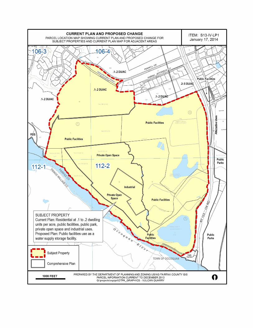
On June 4, 2013, the Board of Supervisors authorized a Comprehensive Plan amendment to
consider the reconfiguration and ultimate reuse of Vulcan Quarry as a water supply storage
facility. The subject area, Tax Maps 106-3((1))4B and 9, 106-4((1))20B (pt.,), 56A pt. and 112-
2((1))8, 9,11,12 and 14, and a portion of right-of-way located south of Peniwill Drive proposed
to be vacated/abandoned are in the Mount Vernon Supervisor District, within the LP1 Laurel Hill
Community Planning Sector in the Lower Potomac Planning District and the P5 Dominion
Community Planning Sector in the Pohick Planning District. Tax Map Parcel 112-2((1))14
contains the Vulcan Quarry onsite office and is located at 10000 Ox Road, Lorton VA, 22079.
Tax Map Parcel 106-4((1))56A pt. contains the Fairfax Water Frederick P. Griffith Treatment
Plant offices and visitor center located at 9584 and 9706 Ox Road, Lorton VA, 22079. The
remaining parcels listed do not have assigned addresses. The Board has directed that staff
consider replanning the subject area for public facilities uses to include a water supply storage
facility.
CHARACTER OF THE SITE
The 527-acre subject area contains the Vulcan Quarry and the Frederick P. Griffith Jr. water
treatment plant owned by Vulcan Materials Company and Fairfax Water, respectively. The
northern pit of the quarry is located within the Pohick Planning District and the southern pit of
the quarry and the Frederick P. Griffith Jr. water treatment plant are located within the Lower
Potomac Planning District. The site is planned for public facilities uses, public park use, private
recreation use and industrial uses and zoned R-C; R-1, I-6 and is partially within the Natural
Resources Overlay District.
CHARACTER OF THE AREA
To the north of the subject area is a neighborhood of low-density single-family homes planned
for residential use at a density of .1-.2 dwelling units per acre and zoned R-1. To the east across
Ox Road (Route 123) are the Occoquan Regional Park planned for public park use and the
Lorton Arts Foundation (Workhouse) property within the Laurel Hill Adaptive Reuse Area,
planned for alternative uses and zoned PDC. To the south is the Occoquan River and the Fairfax
County-Prince William County line and to the west are single-family homes and vacant land
planned for residential use at a density of .1-.2 dwelling units per acre and zoned RC.
PLANNING HISTORY
Staff Report for Plan Amendment S13-IV-LP1
Page 2 of 34
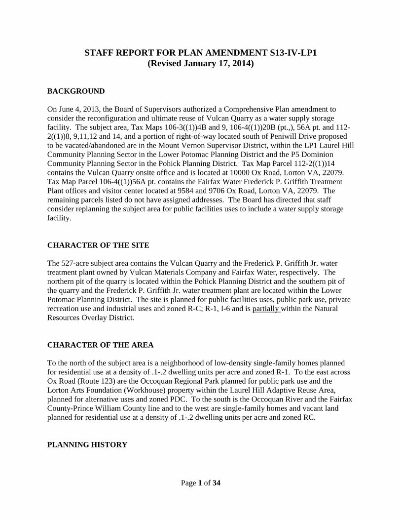
The guidance in the Area IV
volume of the Comprehensive
Plan describes the Vulcan
Quarry as planned for public
park use or private recreation
use after the quarry ceases
mining operations. This
guidance reflects the creation
of the quarry in two phases.
The first phase, included land
located in the southwest
portion of the property that
was leased to Vulcan
Materials Company by the
District of Columbia which
was part of the Lorton
Correctional complex, and
which Vulcan eventually
purchased. The second phase,
included land conveyed to the
Fairfax County Park Authority
by the National Park Service, that was leased to Vulcan Materials Company in 1999, and which
Vulcan eventually purchased in 2009, enabling the Park Authority to acquire what is now known
as Colchester Park and Preserve on land that was deemed suitable for public park use. The land
that Vulcan purchased and proceeded to mine was deemed unsuitable for public park use or for
private recreation use by the Park Authority, and the Park Authority subsequently relinquished
all rights to use the Vulcan property for park and recreation uses. The Comprehensive Plan
guidance has not been updated to reflect these changes.
A portion of the subject area, Tax Map Parcels 106-3((1))4B and 9 that constitute the northern
pit of Vulcan Quarry, were the subject of 2009-2010 South County Area Plans Review
nomination 09-III-4P. The nomination proposed adding text to the P5 Dominion Community
Planning Sector, Pohick Planning District portion of the Comprehensive Plan that stated that the
operations of the Vulcan Quarry were incompatible with the surrounding residential uses and
that the quarry should be closed at the earliest possible time. The Planning Commission denied
the proposed nomination because the nominated area also included land in the LP1 Laurel Hill
Community Planning Sector that was part of an ongoing planning study for the Laurel Hill
Adaptive Reuse Area and therefore was ineligible for consideration.
ADOPTED COMPREHENSIVE PLAN
See Attachment I for adopted Comprehensive Plan text.
Figure 1. Subject Area – Previous Ownership Pattern
Staff Report for Plan Amendment S13-IV-LP1
Page 3 of 34
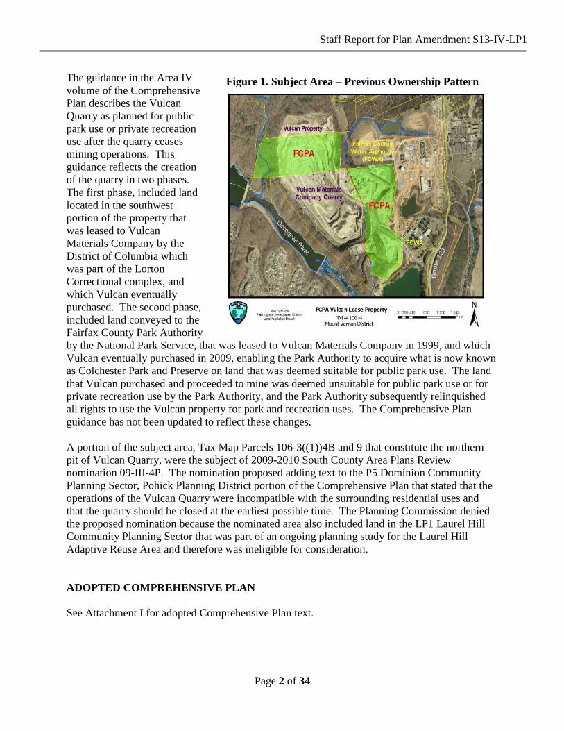
Figure 2. Phasing Plan
PROPOSED PLAN AMENDMENT
Fairfax Water has been pursuing a
long-term strategy to acquire the
Vulcan Quarry for future use as a
water storage facility for almost a
decade. A tentative agreement
was reached that would satisfy
Vulcan’s timeline for completion
of quarrying activities and allow
Fairfax Water to acquire the
quarry for use as a water supply
storage facility by 2085. Interim
steps include the reconfiguration
and conversion of the quarry’s
northern pit to a water supply
storage facility, and interim
relocation of the northern pit
quarrying operations and
relocation of the southern pit stone
crushing operations, cement plant
and stockpiles to land currently
owned by Fairfax Water.
Reconfiguration of the mining
operations area is required in
order to construct a rock wall
between the two pits that is
required to convert the quarry’s
north pit to a water supply storage
facility in 2035. Vulcan would continue quarrying operations in its southern pit until around
2085. In 2085, the southern pit would become a water supply storage facility.
The justification for the proposed Plan amendment relates to long standing regional water supply
planning agreements and recently enacted Virginia water supply regulations. These activities
resulted in the identification of the Vulcan Quarry as a possible alternative to meet the region’s
future demands for drinking water and summarized in the following paragraphs.
“There is a long history of regional water supply planning in the Washington D.C. area. In 1982,
the Washington D.C. metropolitan area water suppliers that included Fairfax Water, the
Washington Aqueduct Division of the U.S. Army Corps of Engineers (WAD), the Washington
Suburban Sanitary Commission (WSSC) and the Interstate Commission on the Potomac River
Basin (ICPRB) signed the Water Supply Coordination Agreement (WSCA). The WSCA
established a framework for water supply planning, drought management, and resource
optimization on the Potomac River. The Section for Cooperative Water Supply Operations on
the Potomac River (CO-OP), a division of the ICPRB and jointly funded by three water
suppliers, conducts studies and provides technical resources for implementing the WSCA. Every

Staff Report for Plan Amendment S13-IV-LP1
Page 4 of 34
five years, the CO-OP of ICPRB conducts a study of projected water demand. The ICPRB
demand forecast process utilizes water use and demographic data along with assumptions
regarding changes in water use patterns in the region. The most recent forecast report was
completed in 2010”. (Water Supply Need and Alternatives Summary Report, Fairfax Water,
August 2010, pages 2-3).
In 2005, the State Water Control Board within the Virginia Department of Environmental
Quality (DEQ), enacted a regulation that requires all local governments to develop local water
supply plans that describe the development of water supply alternatives designed to meet
projected demands for drinking water. DEQ reviews these plans once every ten years. The local
governments of northern Virginia entered into an agreement with the Northern Virginia Regional
Commission (NVRC) to prepare the Water Supply Plan for northern Virginia. The Water
Supply Plan for northern Virginia incorporates the results of the 2010 ICPRB Water Demand
Forecasts. The Board of Supervisors adopted the latest version of the plan on February 28, 2012.
This plan identified Vulcan Quarry as an alternative for meeting future water demands in
northern Virginia through the year 2040. Fairfax Water supplies drinking water not only to
Fairfax County, but also to the cities of Alexandria and Falls Church, Fort Belvoir, the Town of
Herndon and to portions of Prince William and Loudoun counties.
Fairfax Water outlined the benefits of the use of the Vulcan Quarry as a future water supply
facility in their proposed Special Exception Amendment (SEA 81-V-017-2) and Proffer
Condition Amendment applications (PCA 1998-MV-032, 033) dated July 8, 2013. At
completion in 2085, the quarry would store up to 17 billion gallons of water with a yield of
approximately 28-56 million gallons of drinking water per day.
ANALYSIS
Water Supply Alternatives
Fairfax Water’s Water Supply Need & Alternatives Summary Report document dated August
2013 indicates that existing water resources will be adequate through 2030, but by 2040, the
system may have difficulty meeting water supply demands. This is due to projected increases in
demand for water resources attributed to population and employment growth and demand for
water for use in power plant and data center cooling systems. In addition, a reduction in the
volume of available water in the Potomac and Occoquan rivers may occur due to more arid
climate conditions in the future that could result in hotter summers and more severe periods of
drought.
The magnitude of the anticipated shortfall in water supply necessitates the need for the north pit
water supply storage facility (approximately 1.8 BG) by 2035. Together, the northern pit and the
southern pit offer potential future water storage of up to a total of 17 billion gallons.
Staff Report for Plan Amendment S13-IV-LP1
Page 5 of 34
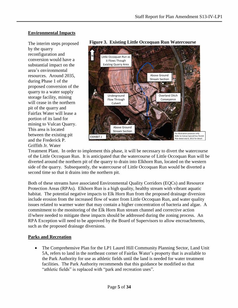
Figure 3. Existing Little Occoquan Run Watercourse
Environmental Impacts
The interim steps proposed
by the quarry
reconfiguration and
conversion would have a
substantial impact on the
area’s environmental
resources. Around 2035,
during Phase 1 of the
proposed conversion of the
quarry to a water supply
storage facility, mining
will cease in the northern
pit of the quarry and
Fairfax Water will lease a
portion of its land for
mining to Vulcan Quarry.
This area is located
between the existing pit
and the Frederick P.
Griffith Jr. Water
Treatment Plant. In order to implement this phase, it will be necessary to divert the watercourse
of the Little Occoquan Run. It is anticipated that the watercourse of Little Occoquan Run will be
diverted around the northern pit of the quarry to drain into Elkhorn Run, located on the western
side of the quarry. Subsequently, the watercourse of Little Occoquan Run would be diverted a
second time so that it drains into the northern pit.
Both of these streams have associated Environmental Quality Corridors (EQCs) and Resource
Protection Areas (RPAs). Elkhorn Run is a high quality, healthy stream with vibrant aquatic
habitat. The potential negative impacts to Elk Horn Run from the proposed drainage diversion
include erosion from the increased flow of water from Little Occoquan Run, and water quality
issues related to warmer water that may contain a higher concentration of bacteria and algae. A
commitment to the monitoring of the Elk Horn Run stream channel and corrective action
if/where needed to mitigate these impacts should be addressed during the zoning process. An
RPA Exception will need to be approved by the Board of Supervisors to allow encroachments,
such as the proposed drainage diversions.
Parks and Recreation
The Comprehensive Plan for the LP1 Laurel Hill Community Planning Sector, Land Unit
5A, refers to land in the northeast corner of Fairfax Water’s property that is available to
the Park Authority for use as athletic fields until the land is needed for water treatment
facilities. The Park Authority recommends that this guidance be modified so that
“athletic fields” is replaced with “park and recreation uses”.
Staff Report for Plan Amendment S13-IV-LP1
Page 6 of 34
The half-acre prison cemetery that is part of the District of Columbia Workhouse and
Reformatory Historic District and National Register District should be preserved.
The Fairfax Countywide Trails Plan designates a major regional trail along the Occoquan
River. The Bull Run Occoquan Trail, the Potomac Heritage National Scenic Trail, the
Fairfax Cross-County Trail, and the Laurel Hill Greenway are planned to connect with
the Bull Run Occoquan Trail at this location. The Northern Virginia Regional Park
Authority (NVRPA) strongly recommends that Fairfax Water permit a public trail within
the property at an appropriate and safe location. Fairfax Water should work with
NVRPA, Fairfax County and interested trail groups to consider a future trail route
through the subject property that meets Fairfax Water security needs. Alternative trail
alignments are limited by existing and planned development.
CONCLUSION
The proposed reconfiguration and conversion in phases of the Vulcan Quarry for a future water
supply storage facility represents a historic opportunity to ensure that Fairfax County and the
region have an adequate supply of potable water well into the next century. While the proposed
Comprehensive Plan guidance supports the concept, significant implementation issues will need
to be addressed at the time of rezoning. Among these are the proposed diversion of Little
Occoquan Run to Elk Horn Run, which will have impacts to existing Resource Protection Areas
and Environmental Quality Corridors. Water quality and drainage impacts will need to be
monitored, and if necessary mitigated. Maintaining the health of Little Occoquan Run during the
diversion period will be crucial as well.
RECOMMENDATION
Staff recommends the Comprehensive Plan be modified as shown below. Text proposed to be
added is shown as underlined and text proposed to be deleted is shown with a strikethrough.
MODIFY: Fairfax County Comprehensive Plan, 2013 Edition, Area IV, Lower Potomac
Planning District, as amended through 4-9-2013, Lower Potomac Planning
District Overview, page 1, paragraph 5:
. . .
“Regional-serving public facilities located in this planning district include the I-95 Energy Resource Recovery Facility, the I-95 Landfill Complex, the Norman M. Cole, Jr. Pollution Control Plant and the Frederick P. Griffith Jr. Water Treatment Plant.” . . .
Staff Report for Plan Amendment S13-IV-LP1
Page 7 of 34
Fairfax County Comprehensive Plan, 2013 Edition, Area IV, Lower Potomac
Planning District, as amended through 4-9-2013, Overview, Public Facilities,
pages 17-18:
“3. Construct a consolidated replacement facility for the FCWA
Lorton/Occoquan Treatment Plants. Consider the conversion of a
reconfigured Vulcan Quarry to a water supply storage facility in order to
meet the long term needs of Fairfax County and the region.”
Staff Report for Plan Amendment S13-IV-LP1
Page 8 of 34
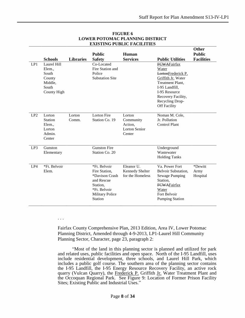
FIGURE 6
LOWER POTOMAC PLANNING DISTRICT
EXISTING PUBLIC FACILITIES
Schools
Libraries
Public
Safety
Human
Services
Public Utilities
Other
Public
Facilities LP1 Laurel Hill
Elem.,
South
County
Middle,
South
County High
Co-Located
Fire Station and
Police
Substation Site
FCWAFairfax
Water
LortonFrederick P.
Griffith Jr. Water
Treatment Plant,
I-95 Landfill,
I-95 Resource
Recovery Facility,
Recycling Drop-
Off Facility
LP2 Lorton
Station
Elem.,
Lorton
Admin.
Center
Lorton
Comm.
Lorton Fire
Station Co. 19
Lorton
Community
Action,
Lorton Senior
Center
Noman M. Cole,
Jr. Pollution
Control Plant
LP3 Gunston
Elementary
Gunston Fire
Station Co. 20
Underground
Wastewater
Holding Tanks
LP4 *Ft. Belvoir
Elem.
*Ft. Belvoir
Fire Station,
*Davison Crash
and Rescue
Station,
*Ft. Belvoir
Military Police
Station
Eleanor U.
Kennedy Shelter
for the Homeless
Va. Power Fort
Belvoir Substation,
Sewage Pumping
Station,
FCWAFairfax
Water
Fort Belvoir
Pumping Station
*Dewitt
Army
Hospital
. . . Fairfax County Comprehensive Plan, 2013 Edition, Area IV, Lower Potomac
Planning District, Amended through 4-9-2013, LP1-Laurel Hill Community
Planning Sector, Character, page 23, paragraph 2: “Most of the land in this planning sector is planned and utilized for park and related uses, public facilities and open space. North of the I-95 Landfill, uses include residential development, three schools, and Laurel Hill Park, which includes a public golf course. The southern area of the planning sector contains the I-95 Landfill, the I-95 Energy Resource Recovery Facility, an active rock quarry (Vulcan Quarry), the Frederick P. Griffith Jr. Water Treatment Plant and the Occoquan Regional Park. See Figure 9: Location of Former Prison Facility Sites; Existing Public and Industrial Uses.”
Staff Report for Plan Amendment S13-IV-LP1
Page 9 of 34
. . .
Fairfax County Comprehensive Plan, 2013 Edition, Area IV, Lower Potomac Planning District, Amended through 4-9-2013, LP1-Laurel Hill Community Planning Sector, Land Use, pages 30-31: Paragraph 1: “The Laurel Hill Community Planning Sector (LP1) can be divided into a southern part and a northern part.northern and southern parts. The southern portion (approximately 1,300 acres) is dominated by the I-95 Landfill, the I-95 Energy/Resource Recovery Facility, the Fairfax Water Facility, the Occoquan Regional Park and the Vulcan Quarry (an active quarry) all of which are planned to be retained for the long term. The northern portion of LP1 is generally defined as the area north of the I-95 Landfill and related facilities and includes the Central Facilityformer D.C. Department of Corrections Lorton facilities, including the Former Reformatory and Penitentiary and the Occoquan Workhouse sites.” Paragraph 8: “The southern portion of LP1 (approximately 1,400 acres) is anticipated to retain the following uses:dominated by the I-95 Landfill, the I-95 Energy/Resource Recovery Facility, and Fairfax Water Facility the Frederick P. Griffith Jr. Water Treatment Plant and the Occoquan Regional Park, and the Vulcan Quarry all of which are planned to be retained for the long term. The Vulcan Quarry (an active rock quarry) is also located in the sector. It is planned to be mined and considered for reconfiguration and conversion in phases to facilitate the creation of a long term water supply storage facility owned by Fairfax Water. The area is planned accordingly for governmental and institutional uses, public park, and private recreation and public facilities.” Paragraph 9: “The Occoquan Regional Park is anticipated to expand northward to the southern boundary of the I-95 Landfill excluding the area of the former Youth Correctional Facility, which is planned for park use by the Fairfax County Park Authority. The Fairfax Water Facility property was expanded to include the area abutting the west side of Ox Road. In addition to the land conveyed to Fairfax Water Facility, land on the west side of Ox Road was also conveyed to the Fairfax County Park Authority.” . . . Fairfax County Comprehensive Plan, 2013 Edition, Area IV, Lower Potomac Planning District, Amended through 4-9-2013, LP1-Laurel Hill Community Planning Sector, Open Space/Pedestrian Systems, page 35: “As indicated previously, the southern part of the LP1 Community Planning Sector is dominated by uses such as the I-95 Landfill, the I-95 Energy/Resource Recovery Facility, the Fairfax Water Facility, and the Occoquan Regional Park and the Vulcan Quarry which are all planned to be retained over the long term. The Vulcan Quarry (an active rock quarry), is also located in the sector. It is planned to be mined, and considered for reconfiguration and conversion in phases

Staff Report for Plan Amendment S13-IV-LP1
Page 10 of 34
to facilitate the creation of a water supply storage facility to be owned by Fairfax Water. The area south of the I-95 Landfill and north of the Occoquan Regional Park is planned for park use, ultimately encompassing the former Youth Correctional Facility.” Fairfax County Comprehensive Plan, 2013 Edition, Area IV, Lower Potomac Planning District, Amended through 4-9-2013, LP1-Laurel Hill Community Planning Sector, Open Space/Pedestrian Systems, page 38: “• The area west of Ox Road, which includes the Fairfax Water Facility and
the Vulcan Quarry, should provide for recreational amenities and buffering for the residential communities abutting to the north and should include the trail connections to the Regional Park System.”
Fairfax County Comprehensive Plan, 2013 Edition, Area IV, Lower Potomac Planning District, Amended through 4-9-2013, LP1-Laurel Hill Community Planning Sector, Public Facilities, page 39:
“The LP1 Planning Sector has several major Countywide public facilities other than parks which are covered under Open Space/Pedestrian Systems. These include the I-95 Landfill, the I-95 Energy/Resource Recovery Facility and the Fairfax Water Facility. These public facilities will remain with the redevelopment of the former Corrections Property. The I-95 Landfill, and the I-95 Energy/Resource Recovery Facility and the Fairfax Water Facility are planned to be retained for the long term. Once the I-95 Landfill stops receiving material it will enter a post-closure care period of 30-years duration. The I-95 Energy/Resource Recovery Facility is under contract until 2016, but anticipated to operate at least until 2031, if not beyond. The Fairfax Water Facility has capacity is required to provide adequate capacity to meet the long-term water treatmentsupply needs for Fairfax County as identified in the Northern Virginia Regional Water Supply Plan, adopted by the Board of Supervisors on February 28, 2012, as may be amended by the Board. The proposed reconfiguration of the Vulcan Quarry and phased conversion to a water supply storage facility is an alternative identified in this Regional Water Supply Plan. These existing and planned public facilities should adhere to the following guidance: • The portions of the I-95 Landfill that no longer receive material should be
considered for adaptive reuse for active and passive recreational purposes and should be part of the long-term expansion program for the Occoquan Regional Park or the Fairfax County Park Authority to further serve the needs of the Northern Virginia area.
• The Fairfax Water Facility should be considered for expansion to include
the adjacent Vulcan Quarry to create a water supply storage facility. The Fairfax Water Facility should be buffered and screened along Ox Road and theits northern boundary. The existing ponds north and south of the treatment facility should be preserved as natural resource areas. As an interim use, land located on the northeast portion of the Fairfax Water Facility may be used by the Fairfax County Park Authority for athletic fieldspark and recreational uses until such time as the area is needed for treatment plant expansion. not needed for the expansion should be used by
Staff Report for Plan Amendment S13-IV-LP1
Page 11 of 34
the Fairfax County Park Authority for athletic fields. A new 42-inch water main is planned to replace the existing main that crosses the former Corrections Property.”
. . . Fairfax County Comprehensive Plan, 2013 Edition, Area IV, Lower Potomac Planning District, Amended through 4-9-2013, LP1-Laurel Hill Community Planning Sector, Land Unit 5, pages 52-54: “Sub-unit 5A: Approximately 115 acres of the land within Sub-unit 5A, generally located south of the former Corrections Property line, west of Ox Road and north of the Occoquan River, is to be conveyed to the Fairfax County Park Authority. A portion of this property is currently being leased and used for extraction by Vulcan Quarry. North of the Occoquan River between the quarry and Ox Road, is the approximately 250247-acre Fairfax Water Facility property. Both of these uses should adhere to the following additional guidance: Buffering and screening along Ox Road and the northern boundary should be provided. The buffer area along the northern boundary should include that area’s pond. In addition, if reconfiguration of the quarry is approved, a buffer area should be provided adjacent to the existing solids disposal area and the former Lorton treatment plant located south of the existing Frederick P. Griffith Jr. treatment facility to screen Route 123 from impacts created by the reconfigured mining area and relocation of the quarry’s stone crushing operations to this area. As an interim use, land located on the northeast portion of the Fairfax Water Facility may be used by the Park Authority for park and recreational uses until such time as the area is needed for treatment plant expansion. The half-acre prison cemetery, which was established at the turn of the 20
th century, located west of
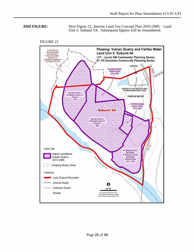
the former Occoquan Workhouse on the Fairfax Water property, should be preserved. The Fairfax Water Facility property has been expanded extends northward to the northern boundary of the LP1 Laurel Hill Community Planning Sector. In order to meet the long term watertreatment supply storage needs forof Fairfax County.Buffering and screening along Ox Road and the northern boundary should be provided. The buffer area along the northern boundary should include that area’s pond and any sensitive biological areas associated with the pond. In addition, a buffer area should be provided adjacent to the pond located south of the new treatment facility in order to protect this natural resource area. In addition, the treatment plant expansion should be designed in a manner that will ensure future access to the quarry property on the west after its reclamation occurs. and the region, a water supply storage facility may be considered for establishment on lands currently owned by the Vulcan Quarry and Fairfax Water. Phasing is envisioned to occur as follows: • The northern portion of the Vulcan Quarry would be available to Fairfax
Water in approximately 2035, when mining operations in this area would cease. At that time, this portion of the quarry would be converted to serve as Phase 1 of the planned water supply storage facility (shown on Figure 21). Additional land would be leased to Vulcan Quarry by Fairfax Water prior to Phase 1 to facilitate reconfiguration of the stone mining operations to replace lost capacity from the conversion of the northern portion of the quarry for water supply storage purposes, for relocation of the quarry’s

Staff Report for Plan Amendment S13-IV-LP1
Page 12 of 34
stone crushing operations and for storage space for overburden (topsoil and excess material) from mining activities. Mining operations on the southern portion of the quarry would continue until about 2085.
• The entirety of Vulcan Quarry land would be acquired by Fairfax Water about 2085. All quarry operations would then cease. At this time, the southern portion of the quarry would be converted to serve as Phase 2 of the new water supply storage facility. The locations described for the proposed conversion of the Vulcan Quarry to a water supply storage facility are shown in Figure 21.
Evaluation of any proposal for any long term water supply storage areas should consider the following direct and indirect impacts to Environmental Quality Corridors (EQCs) and Resource Protection Areas (RPAs), as well as impacts created by proposed stream diversions. The following issues should be resolved during the review of any rezoning, special permit, special exception and proffer condition amendment applications: • The extent to which the proposed water supply storage facility is needed to
address short, medium and long term water supply needs;
• The extent to which the proposed action would meet the long term water supply needs with the least amount of adverse environmental impact, compared to other alternatives;
• The extent to which any existing buffer areas will be removed or impacted
by any proposed stream diversion;
• The placement and orientation of proposed temporary mining capacity augmentation areas should be evaluated in order to avoid and/or minimize impacts to EQCs, RPAs and streams;
• The extent of any impacts that the proposal would have on EQCs and
measures that would be pursued to address Policy Plan guidance regarding disturbances to EQCs;
• The extent of any impacts that the proposal would have on RPAs and
measures that would be taken in support of an exception under Chapter 118 of the Fairfax County Code (the Chesapeake Bay Preservation Ordinance); and;
• The extent to which there would be any proposed diversion of drainage that
would be needed to implement the proposal and the measures that would be pursued to ensure that any such drainage diversion would not have adverse impacts on receiving waters;.
• Extraction at the quarry should be predicated on the assumption that severe
slopes, especially adjacent to swales and streams, will not be disturbed so as to pose a direct threat to stream water quality. Consequently, limits of clearing for proposed extraction sites should not encroach on severe slopes in such a manner as to render impossible sediment control and/or visual buffering for nearby residents. Further, sediment control measures should
Staff Report for Plan Amendment S13-IV-LP1
Page 13 of 34
be adequate to control erosion in conformance with the guidelines of the County sediment and erosion control regulations. A natural buffer of at least one hundred feet along the southwest line of the property parallel to the Occoquan CreekRiver should be maintained; In addition, within six months of final fill grade, or as soon thereafter as possible, the visual berm areas along the southwesterly property line, the northwest and southern corners of the property and at the creek entrance to the property along the northern property line should be planted. The plantings should consist of ground cover and evergreen trees. Upon completion of operations, the land should be left in a safe and stabilized condition so that the area can be developed for public park or private recreation uses as shown on the Comprehensive Plan map.
• The Fairfax Water Facility property has been expanded northward to the
northern boundary of LP.1 iIn order to meet the long term water treatment needs for Fairfax County. Buffering and screening along Ox Road and the northern boundary should be provided. The buffer area along the northern boundary should include that area’s pond and any sensitive biological areas associated with the pond. In addition, a buffer area should be provided adjacent to the pond located south of the new treatment facility in order to protect this natural resource area. In addition, the treatment plant expansion should be designed in a manner that will ensure future access to the quarry property on the west after its reclamation occurs.
• Any land not needed for the Fairfax Water Facility should be used for park
purposes, including interim uses, such as athletic fields. • The half-acre prison cemetery, which was established at the turn of the 20
th
century, located west of the former Occoquan Workhouse and north of the Vulcan Quarry, should be preserved.
. . . Fairfax County Comprehensive Plan, 2013 Edition, Area III, Pohick Planning District, Amended through 4-9-2013, Overview, pages 15-16: . . . 7. Renovate and expand the FCWA Fairfax Water Popes Head Road Pumping Station in Sector P1. 8. Renovate and expand the FCWA Fairfax Water Pohick Pumping Station in Sector P6. 9. The Vulcan Quarry should be considered for reconfiguration and conversion in phases for use as a water supply storage facility in order to meet the long term water supply needs of Fairfax County and the region. The Fairfax Water Facility is planned to expand to include the reconfigured quarry when the conversion has been implemented.
FIGURE 6 POHICK PLANNING DISTRICT EXISTING PUBLIC FACILITIES

Staff Report for Plan Amendment S13-IV-LP1
Page 14 of 34
Schools
Libraries
Public
Safety
Human Services
Public Utilities
Other Public
Facilities P1 Centreville
High
Mott Community
Center
Popes Head
Sewage Pumping
Station, FCWA
Fairfax Water
Popes Head
Road Pumping
Station
P2 Burke Spec. Ed. Center, Bonnie Brae, Laurel Ridge, Rolling Valley, Hunt Valley, Oak View, Saratoga, White Oaks Elem., Robinson and Lake Braddock Sec., W. Springfield High, 3 Elem. Sites
Kings Park Community
Braddock District Supervisor’s Office, Burke Fire Station Co. 14, West Springfield Police Station, Fire Station Co. 27 and Government Center
David R. Pinn Community Center, Cluster Residences for Mentally Retarded Adults, *No. Va. Training Center (State)
Va. Power Burke, Keene Mill and Sideburn Substations, 4 Storm Drainage Impoundments (P.L. 566)
*State Police Park-and-Ride
P3 Clifton Elem., Liberty Middle
P4 Clifton Fire Station Co. 16
P5 Silverbrook, Halley Elem.
Fairview Fire Station Co. 32
Va. Power Ox and Occoquan Substations
P6 Fairview, Cherry Run, Sangster, Orange Hunt, Terra Centre Elem.
Pohick Regional, Burke Centre Community Library site
Pohick Fire Station Co. 35
1 Stormwater Impoundment, Public Works Line Maintenance Division Shop, FCWA Fairfax Water Pohick Road Pumping Station
Park-and-Ride
P7 Newington Forest Elem.
Storm Drainage Impoundment, Pohick Road Sewage Pumping Station
. . .
Staff Report for Plan Amendment S13-IV-LP1
Page 15 of 34
Fairfax County Comprehensive Plan, 2013 Edition, Area III, Pohick Planning District, Amended through 4-9-2013, Overview, pages 62-63: 7. The area immediatelygenerally to the north of the existing quarry operationPeniwill Drive is planned for residential use at .1-.2 dwelling unit per acre as shown on the Comprehensive Plan Map. As an option, Parcels 106-3((1))4B, 106-4((1))1B and 20B pt. (not including property adjacent to the north side of Peniwill Drive) may be appropriate for an expansion of the existing quarry to the south, located in Community Planning Sector LP1 in Area IV. The quarry pit limits to the west and north near Peniwill Drive should not be extended further west or north than currently exists. Industrial uses other than the expansion of the quarry or conversion of the quarry to a water storage facility are not planned in this area nor should they be permitted. As this area is adjacent to lands planned for very low density residential use, the quarry expansion area in this planning sector should be limited in size and well buffered from adjacent parcels. In addition, the environmental impacts of the expansion any quarry activities outside of this planning sector should be mitigated and safe and adequate road access provided. The expansion of the quarry operations in this location is only are only appropriate if the following conditions are met: • The current operating conditions remain in effect; • The expansion of the quarry pit and operations area in this community
planning sector should be limited in size and location to insure that the impact of this use on surrounding uses is mitigated. This will provide for a supply of stone resources sufficient to meet demand for many years while assuring the quarry expansion will be finite in this location and will protect the residential character of the areas to the north, east and west from further expansion of nonresidential uses;
• The proposed pit expansion area should be limited to approximately 30 32
acres in the southern portion of Parcel 106-3((1))4B and should be contiguous with the existing pit located in Area IV; storage and equipment areas, settlement ponds, and access ways any other areas of disturbance within the P5 Dominion Community Planning Sector should be located on approximately 30 to 40 acres; and a buffer area should consist of approximately 45 to 55 acres. ThisA vegetative buffer should be provided around the periphery of the site and should include Environmental Quality Corridors (EQCs) and the maximum amount feasible of mature hardwood forests. In addition to including EQC and forest areas, this vegetative buffer should be 100 to 200 feet in width may also include berms to protect all existing or planned residential development from noise and visual impacts of the quarrying operations. Supplemental plantings should be provided in the buffer where no mature trees exist;
• The direct and the indirect environmental impacts of any proposed quarry
expansionreconfiguration and conversion to a water supply storage facility should be appropriately mitigated. The scope of the quarry expansionreconfiguration and conversion should be designed to balance efficient stone removal with preservation of significant environmental resources such as EQCs and adjacent upland hardwood tree cover. In addition to the buffer area described above, other critical EQC areas and significant areas of upland hardwood forest cover adjacent to the EQCs
Staff Report for Plan Amendment S13-IV-LP1
Page 16 of 34
should be preserved to the maximum extent feasible. The applicant should comply with all requirements of the Chesapeake Bay Preservation Act;
• The quarry expansionoperations should be carefully planned to provide
siltation basins that will contain sediment on-site and prevent off-site discharges that could adversely impact water quality. The pit drainage systemAny proposal to modify the should be carefully designed to maintain pre-quarry drainage patterns as a result of quarry operations or diversion of drainage around the quarry should be pursued in a manner that will ensure that bodies of water receiving new and/or increased discharges of water will be protected from any associated adverse impacts. to the extent feasible. Tree cover on the site should be maintained as long as possible. Erosion and sediment controls should be in place prior to any clearing of expansion areas;
• The quarry operator should provide necessary improvements at the site
entrance to Ox Road and along Ox Road near the intersection as may be required by Virginia Department of Transportation (VDOT);
• The proposed expansion of the quarry should only use the existing access
road through the Fairfax Water Authority property. A second access for emergency vehicles only should be provided to Ox Road. No use of any additional access points is recommended along Ox Road for daily quarry operations; and
• Alternative public street access to Route 123 (Ox Road) should be provided
to the residential land west of Elk Horn Run and should be well-buffered from all quarrying operations.
In order to meet the long term water supply storage needs of Fairfax County and the region, a water supply storage facility may be considered for establishment on lands currently owned by the Vulcan Quarry. The first phase of the water supply storage facility conversion would include Tax Map Parcels 106-3 ((1)) 4B, which is located in the northern portion of Vulcan Quarry. During this phase, mining operations in this northern area would cease and this portion of the reconfigured quarry would be used for water supply storage beginning around 2035 (shown on Figure 21). Guidance for the evaluation of any proposal affecting the Vulcan Quarry property for any new long-term water supply storage areas is provided within the recommendations for Land Unit 5 of the Laurel Hill Community Planning Sector in the Area IV Plan.”
Staff Report for Plan Amendment S13-IV-LP1
Page 17 of 34
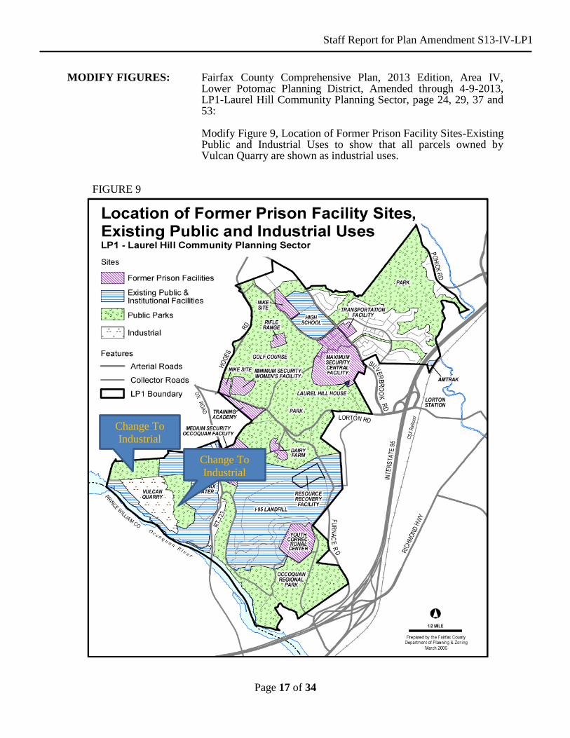
MODIFY FIGURES: Fairfax County Comprehensive Plan, 2013 Edition, Area IV, Lower Potomac Planning District, Amended through 4-9-2013, LP1-Laurel Hill Community Planning Sector, page 24, 29, 37 and 53:
Modify Figure 9, Location of Former Prison Facility Sites-Existing
Public and Industrial Uses to show that all parcels owned by Vulcan Quarry are shown as industrial uses.
FIGURE 9
Change To
Industrial
Change To
Industrial

Staff Report for Plan Amendment S13-IV-LP1
Page 18 of 34
Modify Figure 11, Land Use Concept Plan to show that all parcels owned by Vulcan Quarry are shown as public facilities uses.
FIGURE 11
Change To Public
Facilities
Change To Public
Facilities
Change To Public
Facilities
Staff Report for Plan Amendment S13-IV-LP1
Page 19 of 34
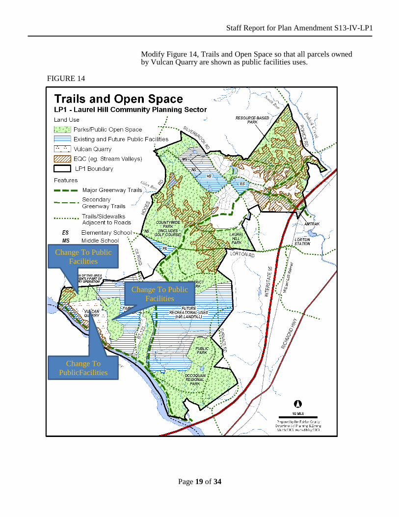
Modify Figure 14, Trails and Open Space so that all parcels owned by Vulcan Quarry are shown as public facilities uses.
FIGURE 14
Change To Public
Facilities
Change To
PublicFacilities
Change To Public
Facilities

Staff Report for Plan Amendment S13-IV-LP1
Page 20 of 34
Modify Figure 20, Land Unit 5: Subunits 5A & B, so that all
parcels owned by Vulcan Quarry are shown as public facilities
uses.
FIGURE 20
Staff Report for Plan Amendment S13-IV-LP1
Page 21 of 34
ADD FIGURE: New Figure 21, Interim Land Use Concept Plan 2035-2085 – Land Unit 5: Subunit 5A. Subsequent figures will be renumbered.
FIGURE 21

Staff Report for Plan Amendment S13-IV-LP1
Page 22 of 34
PLAN MAP: The Comprehensive Plan map will be modified to show the
entirety of the subject area as planned for public facilities uses.
Staff Report for Plan Amendment S13-IV-LP1
Page 23 of 34
ATTACHEMENT I
ADOPTED COMPREHENSIVE PLAN TEXT
Lower Potomac Planning District
Fairfax County Comprehensive Plan, 2011 Edition, Area IV, Lower Potomac Planning
District, Amended through 4-9-2013, Overview, Page 1:
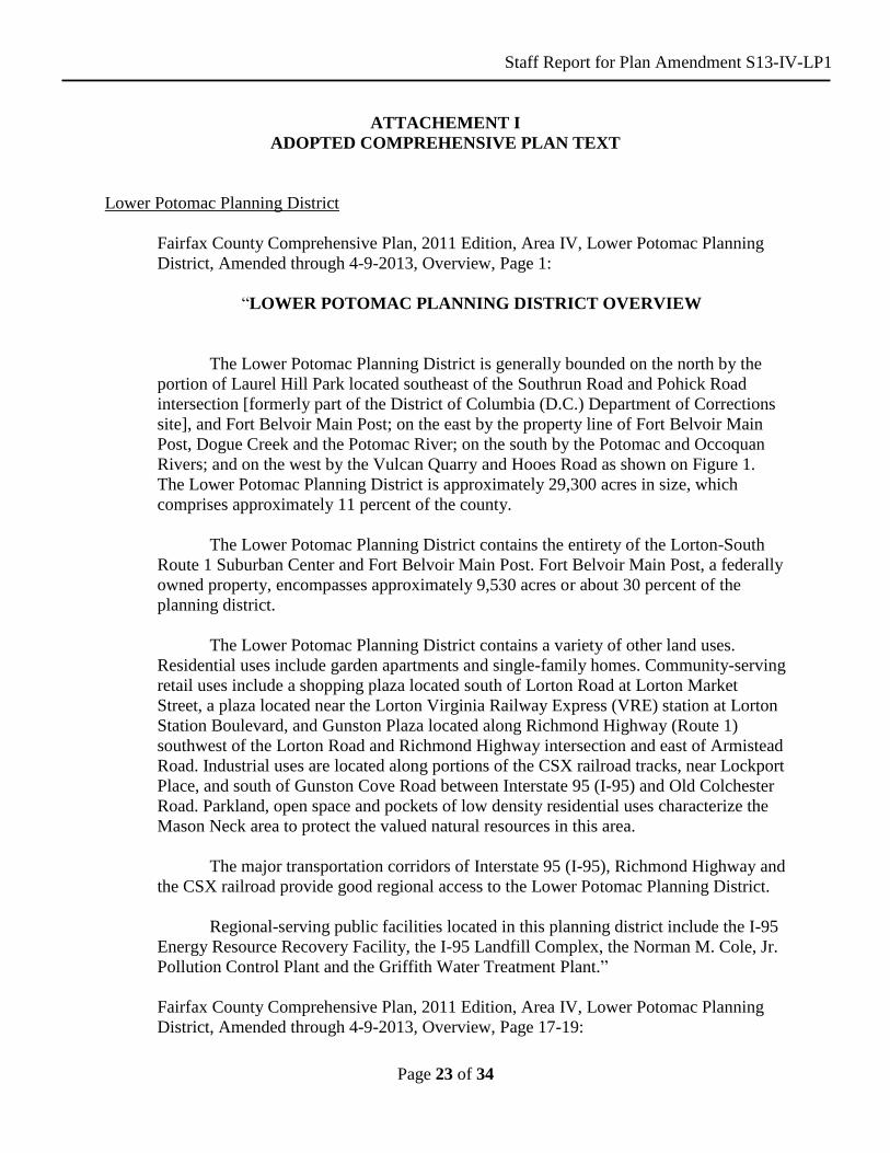
“LOWER POTOMAC PLANNING DISTRICT OVERVIEW
The Lower Potomac Planning District is generally bounded on the north by the
portion of Laurel Hill Park located southeast of the Southrun Road and Pohick Road
intersection [formerly part of the District of Columbia (D.C.) Department of Corrections
site], and Fort Belvoir Main Post; on the east by the property line of Fort Belvoir Main
Post, Dogue Creek and the Potomac River; on the south by the Potomac and Occoquan
Rivers; and on the west by the Vulcan Quarry and Hooes Road as shown on Figure 1.
The Lower Potomac Planning District is approximately 29,300 acres in size, which
comprises approximately 11 percent of the county.
The Lower Potomac Planning District contains the entirety of the Lorton-South
Route 1 Suburban Center and Fort Belvoir Main Post. Fort Belvoir Main Post, a federally
owned property, encompasses approximately 9,530 acres or about 30 percent of the
planning district.
The Lower Potomac Planning District contains a variety of other land uses.
Residential uses include garden apartments and single-family homes. Community-serving
retail uses include a shopping plaza located south of Lorton Road at Lorton Market
Street, a plaza located near the Lorton Virginia Railway Express (VRE) station at Lorton
Station Boulevard, and Gunston Plaza located along Richmond Highway (Route 1)
southwest of the Lorton Road and Richmond Highway intersection and east of Armistead
Road. Industrial uses are located along portions of the CSX railroad tracks, near Lockport
Place, and south of Gunston Cove Road between Interstate 95 (I-95) and Old Colchester
Road. Parkland, open space and pockets of low density residential uses characterize the
Mason Neck area to protect the valued natural resources in this area.
The major transportation corridors of Interstate 95 (I-95), Richmond Highway and
the CSX railroad provide good regional access to the Lower Potomac Planning District.
Regional-serving public facilities located in this planning district include the I-95
Energy Resource Recovery Facility, the I-95 Landfill Complex, the Norman M. Cole, Jr.
Pollution Control Plant and the Griffith Water Treatment Plant.”
Fairfax County Comprehensive Plan, 2011 Edition, Area IV, Lower Potomac Planning
District, Amended through 4-9-2013, Overview, Page 17-19:
Staff Report for Plan Amendment S13-IV-LP1
Page 24 of 34
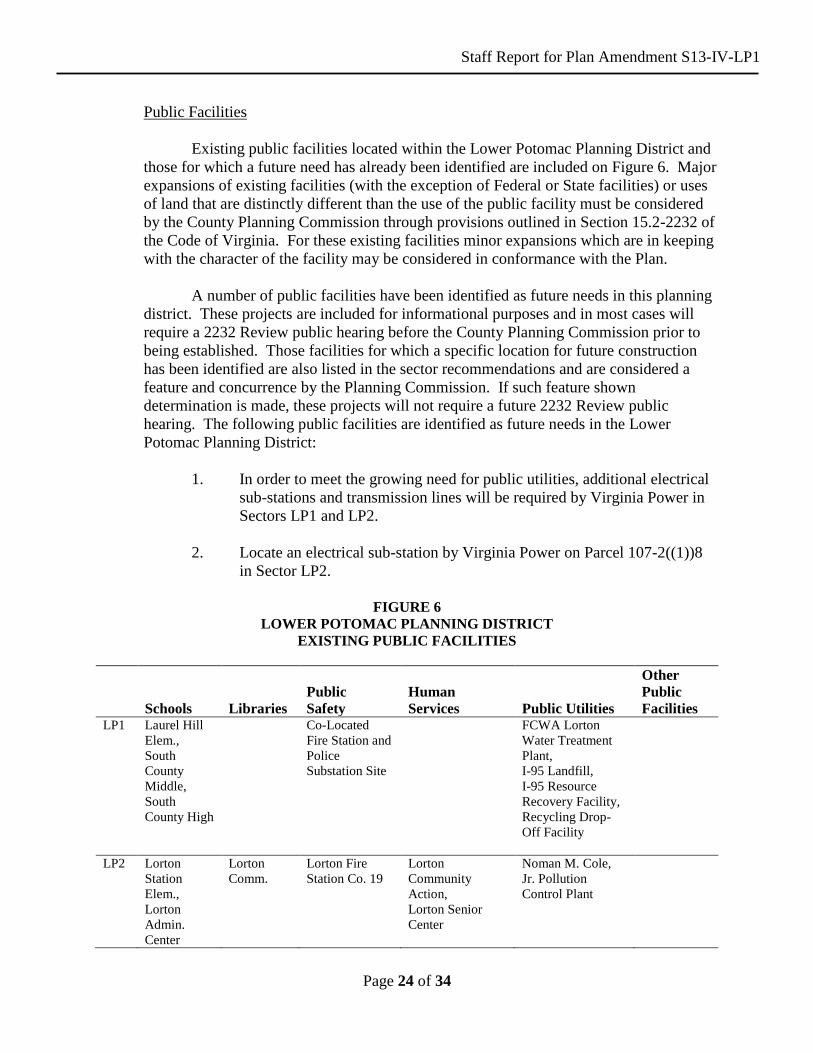
Public Facilities
Existing public facilities located within the Lower Potomac Planning District and
those for which a future need has already been identified are included on Figure 6. Major
expansions of existing facilities (with the exception of Federal or State facilities) or uses
of land that are distinctly different than the use of the public facility must be considered
by the County Planning Commission through provisions outlined in Section 15.2-2232 of
the Code of Virginia. For these existing facilities minor expansions which are in keeping
with the character of the facility may be considered in conformance with the Plan.
A number of public facilities have been identified as future needs in this planning
district. These projects are included for informational purposes and in most cases will
require a 2232 Review public hearing before the County Planning Commission prior to
being established. Those facilities for which a specific location for future construction
has been identified are also listed in the sector recommendations and are considered a
feature and concurrence by the Planning Commission. If such feature shown
determination is made, these projects will not require a future 2232 Review public
hearing. The following public facilities are identified as future needs in the Lower
Potomac Planning District:
1. In order to meet the growing need for public utilities, additional electrical
sub-stations and transmission lines will be required by Virginia Power in
Sectors LP1 and LP2.
2. Locate an electrical sub-station by Virginia Power on Parcel 107-2((1))8
in Sector LP2.
FIGURE 6
LOWER POTOMAC PLANNING DISTRICT
EXISTING PUBLIC FACILITIES
Schools
Libraries
Public
Safety
Human
Services
Public Utilities
Other
Public
Facilities LP1 Laurel Hill
Elem.,
South
County
Middle,
South
County High
Co-Located
Fire Station and
Police
Substation Site
FCWA Lorton
Water Treatment
Plant,
I-95 Landfill,
I-95 Resource
Recovery Facility,
Recycling Drop-
Off Facility
LP2 Lorton
Station
Elem.,
Lorton
Admin.
Center
Lorton
Comm.
Lorton Fire
Station Co. 19
Lorton
Community
Action,
Lorton Senior
Center
Noman M. Cole,
Jr. Pollution
Control Plant
Staff Report for Plan Amendment S13-IV-LP1
Page 25 of 34
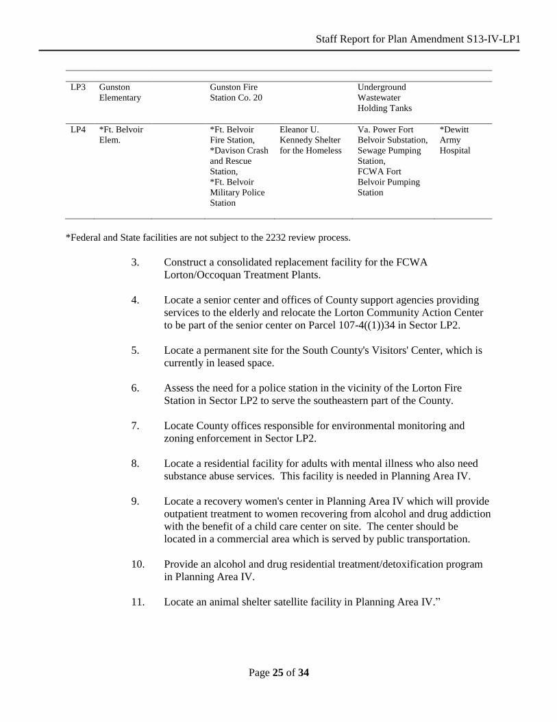
LP3 Gunston
Elementary
Gunston Fire
Station Co. 20
Underground
Wastewater
Holding Tanks
LP4 *Ft. Belvoir
Elem.
*Ft. Belvoir
Fire Station,
*Davison Crash
and Rescue
Station,
*Ft. Belvoir
Military Police
Station
Eleanor U.
Kennedy Shelter
for the Homeless
Va. Power Fort
Belvoir Substation,
Sewage Pumping
Station,
FCWA Fort
Belvoir Pumping
Station
*Dewitt
Army
Hospital
*Federal and State facilities are not subject to the 2232 review process.
3. Construct a consolidated replacement facility for the FCWA
Lorton/Occoquan Treatment Plants.
4. Locate a senior center and offices of County support agencies providing
services to the elderly and relocate the Lorton Community Action Center
to be part of the senior center on Parcel 107-4((1))34 in Sector LP2.
5. Locate a permanent site for the South County's Visitors' Center, which is
currently in leased space.
6. Assess the need for a police station in the vicinity of the Lorton Fire
Station in Sector LP2 to serve the southeastern part of the County.
7. Locate County offices responsible for environmental monitoring and
zoning enforcement in Sector LP2.
8. Locate a residential facility for adults with mental illness who also need
substance abuse services. This facility is needed in Planning Area IV.
9. Locate a recovery women's center in Planning Area IV which will provide
outpatient treatment to women recovering from alcohol and drug addiction
with the benefit of a child care center on site. The center should be
located in a commercial area which is served by public transportation.
10. Provide an alcohol and drug residential treatment/detoxification program
in Planning Area IV.
11. Locate an animal shelter satellite facility in Planning Area IV.”
Staff Report for Plan Amendment S13-IV-LP1
Page 26 of 34
Fairfax County Comprehensive Plan, 2011 Edition, Area IV, Lower Potomac Planning
District, Amended through 4-9-2013, LP1 Laurel Hill Community Planning Sector, Page
23:
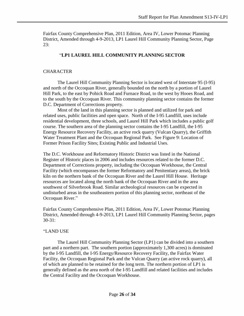
“LP1 LAUREL HILL COMMUNITY PLANNING SECTOR
CHARACTER
The Laurel Hill Community Planning Sector is located west of Interstate 95 (I-95)
and north of the Occoquan River, generally bounded on the north by a portion of Laurel
Hill Park, to the east by Pohick Road and Furnace Road, to the west by Hooes Road, and
to the south by the Occoquan River. This community planning sector contains the former
D.C. Department of Corrections property.
Most of the land in this planning sector is planned and utilized for park and
related uses, public facilities and open space. North of the I-95 Landfill, uses include
residential development, three schools, and Laurel Hill Park which includes a public golf
course. The southern area of the planning sector contains the I-95 Landfill, the I-95
Energy Resource Recovery Facility, an active rock quarry (Vulcan Quarry), the Griffith
Water Treatment Plant and the Occoquan Regional Park. See Figure 9: Location of
Former Prison Facility Sites; Existing Public and Industrial Uses.
The D.C. Workhouse and Reformatory Historic District was listed in the National
Register of Historic places in 2006 and includes resources related to the former D.C.
Department of Corrections property, including the Occoquan Workhouse, the Central
Facility (which encompasses the former Reformatory and Penitentiary areas), the brick
kiln on the northern bank of the Occoquan River and the Laurel Hill House. Heritage
resources are located along the north bank of the Occoquan River and in the area
southwest of Silverbrook Road. Similar archeological resources can be expected in
undisturbed areas in the southeastern portion of this planning sector, northeast of the
Occoquan River.”
Fairfax County Comprehensive Plan, 2011 Edition, Area IV, Lower Potomac Planning
District, Amended through 4-9-2013, LP1 Laurel Hill Community Planning Sector, pages
30-31:
“LAND USE
The Laurel Hill Community Planning Sector (LP1) can be divided into a southern
part and a northern part. The southern portion (approximately 1,300 acres) is dominated
by the I-95 Landfill, the I-95 Energy/Resource Recovery Facility, the Fairfax Water
Facility, the Occoquan Regional Park and the Vulcan Quarry (an active rock quarry), all
of which are planned to be retained for the long term. The northern portion of LP1 is
generally defined as the area north of the I-95 Landfill and related facilities and includes
the Central Facility and the Occoquan Workhouse.

Staff Report for Plan Amendment S13-IV-LP1
Page 27 of 34
The former D.C. Department of Corrections facilities, except for the former
Youth Correctional Facility, are primarily located in the northern portion of Planning
Sector LP1 (approximately 1,900 acres). These facilities include the Medium Security
Occoquan Facility, the Dairy Farm, the Minimum Security Facility, the Central Facility,
and the Transportation Facility. These former facilities are separated by large expanses of
open space and extensive EQCs, which encompass approximately twenty-five percent of
this portion of the planning sector.
While most of the northern portion of LP1 is planned for open space, parkland,
recreation and public facilities, a portion of the area north of Silverbrook Road is planned
for residential development and the former Central Facility area and adjacent land south
of Silverbrook Road are planned for a mix of uses.
The EQC system, heritage resources, and the biologically sensitive areas located
on the northern portion of LP1 are envisioned to be preserved as major resources by
being incorporated into several County parks. Some of the EQC and heritage resources
are connected by a public golf course, located between Silverbrook Road and Giles Run,
linking the Rocky Branch EQC with the Giles Run EQC. A major greenway trail that
utilizes the old rail bed traverses LP1 from the northeastern corner and will ultimately
connect with the Occoquan Regional Park.
The residential neighborhoods located north of Silverbrook Road have developed
in a manner that connects them with the surrounding open space system. This area has
developed at densities of 1-2, 2-3, and 4-5 du/ac calculated on the developable land
excluding EQC areas.
The Redevelopment Area on the northwestern portion of the former Central
Facility is approved for housing oriented to active adults and independent seniors. The
remainder of the former Central Facility (Reformatory and Penitentiary) is planned for
adaptive reuse and new development as detailed in Land Unit 3B. At this location as
well as the Occoquan facility, structures determined to be of historic significance are
anticipated for adaptive reuse. (See Figure 12 for an example of one of these structures.)
The former Occoquan Workhouse has been approved for and redeveloped as an arts
center.
The remainder of the northern portion of LP1 is planned for public facilities as
shown on Figure 11: Land Use Concept Plan. Figure 11 indicates the location of the
elementary, middle, and high school sites as well as a future fire station.
The southern portion of LP1 is anticipated to retain the following uses: the I-95
Landfill, the I-95 Energy/Resource Recovery Facility, Fairfax Water Facility, the
Occoquan Regional Park and the Vulcan Quarry. The area is planned accordingly for
governmental and institutional uses, public park, and private recreation.
The Occoquan Regional Park is anticipated to expand northward to the southern
boundary of the I-95 Landfill excluding the area of the former Youth Correctional

Staff Report for Plan Amendment S13-IV-LP1
Page 28 of 34
Facility, which is planned for park use by the Fairfax County Park Authority. The Fairfax
Water Facility property was expanded to include the area abutting the west side of Ox
Road. In addition to the land conveyed to Fairfax Water Facility, land on the west side of
Ox Road was also conveyed to Fairfax County Park Authority.”
Fairfax County Comprehensive Plan, 2011 Edition, Area IV, Lower Potomac Planning
District, Amended through 4-9-2013, LP1 Laurel Hill Community Planning Sector, page
35:
“OPEN SPACE/PEDESTRIAN SYSTEMS
As indicated previously, the southern part of the LP1 Community Planning Sector
is dominated by uses such as the I-95 Landfill, the I-95 Energy/Resource Recovery
Facility, Fairfax Water Facility, the Occoquan Regional Park and the Vulcan Quarry
which are all planned to be retained over the long term. The area south of the I-95
Landfill and north of the Occoquan Regional Park is planned for park use, ultimately
encompassing the former Youth Correctional Facility.”
Fairfax County Comprehensive Plan, 2011 Edition, Area IV, Lower Potomac Planning
District, Amended through 4-9-2013, LP1 Laurel Hill Community Planning Sector, page
39:
“PUBLIC FACILITIES
The LP1 Planning Sector has several major Countywide public facilities other
than parks which are covered under Open Space/Pedestrian Systems. These include the I-
95 Landfill, the I-95 Energy/Resource Recovery Facility and the Fairfax Water Facility.
These public facilities will remain with the redevelopment of the former Corrections
Property. The I-95 Landfill and the I-95 Energy/Resource Recovery Facility are planned
to be retained for the long term. Once the I-95 Landfill stops receiving material it will
enter a post-closure care period of 30-years duration.
The I-95 Energy/Resource Recovery Facility is under contract until 2016, but
anticipated to operate at least until 2031, if not beyond. The Fairfax Water Facility has
capacity to meet the long-term water treatment needs for Fairfax County. These existing
public facilities should adhere to the following guidance:
• The portions of the I-95 Landfill that no longer receive material should be
considered for adaptive reuse for active and passive recreational purposes and
should be part of the long-term expansion program for the Occoquan Regional
Park or the Fairfax County Park Authority to further serve the needs of the
Northern Virginia area.
• The Fairfax Water Facility should be buffered and screened along Ox Road and
the northern boundary. The existing ponds north and south of the treatment
facility should be preserved as natural resource areas. As an interim use, land not
Staff Report for Plan Amendment S13-IV-LP1
Page 29 of 34
needed for the expansion should be used by the Fairfax County Park Authority for
athletic fields. A new 42-inch water main is planned to replace the existing main
that crosses the former Corrections Property.
With redevelopment of the former Corrections Property, additional public
facilities and utilities will be needed to serve the property as well as the surrounding
community.
Public Facilities Recommendations and Guidelines: The following recommendations and
guidelines to implement the public facility and utility needs of any redevelopment of the
former Corrections Property are provided:
• If a site for Fire and Rescue has not been located off-site to serve this area, then a
site of approximately five acres should be provided on the former Corrections
Property. The location of that site may be on the south side of Furnace Road
between Hooes Road and Lorton Road as shown on Figure 11, with the specific
site location to be coordinated with Fire and Rescue. In addition, there should be
the potential for a future police substation, which may collocate with the fire and
rescue station.
• Adaptive reuse of existing buildings for public facilities should be provided as
indicated in the Land Unit Recommendations.
• Utility easements and right-of-ways will be necessary as older lines are replaced
or new ones are needed to provide utility services to future development in the
area.”
Fairfax County Comprehensive Plan, 2011 Edition, Area IV, Lower Potomac Planning
District, Amended through 4-9-2013, LP1 Laurel Hill Community Planning Sector, pages
52-54:
“LAND UNIT 5
Land Unit 5 is comprised of approximately 590 acres of which about 15 percent is
in environmentally sensitive areas (see Figure 20). Approximately 200 acres of this land
unit is located outside of the former Corrections Property boundary and is currently used
by Vulcan Quarry and the Fairfax Water Facility. The land unit is generally bounded by
the Occoquan River to the south, Mills Branch to the east, the former Corrections
Property line to the north and the American Telephone and Telegraph Easement to the
west.
A major historic feature in Land Unit 5 is the former Occoquan Workhouse and
related ancillary masonry buildings located immediately to the east of Ox Road. The
former Occoquan Workhouse complex has the greatest potential for adaptive reuse.
Development of this land unit should be in accordance with the guidance for the sub-
units.
Staff Report for Plan Amendment S13-IV-LP1
Page 30 of 34
Sub-unit 5A: Approximately 115 acres of the land within Sub-unit 5A, generally located
south of the former Corrections Property line, west of Ox Road and north of the
Occoquan River, is to be conveyed to the Fairfax County Park Authority. A portion of
this property is currently being leased and used for extraction by Vulcan Quarry. North
of the Occoquan River between the quarry and Ox Road, is the approximately 250-acre
Fairfax Water Facility property. Both of these uses should adhere to the following
additional guidance:
• Extraction at the quarry should be predicated on the assumption that severe
slopes, especially adjacent to swales and streams, will not be disturbed so as to
pose a direct threat to stream water quality. Consequently, limits of clearing for
proposed extraction sites should not encroach on severe slopes in such a manner
as to render impossible sediment control and/or visual buffering for nearby
residents. Further, sediment control measures should be adequate to control
erosion in conformance with the guidelines of the County sediment and erosion
control regulations. A natural buffer of at least one hundred feet along the
southwest line of the property parallel to the Occoquan Creek should be
maintained. In addition, within six months of final fill grade, or as soon thereafter
as possible, the visual berm areas along the southwesterly property line, the
northwest and southern corners of the property and at the creek entrance to the
property along the northern property line should be planted. The plantings should
consist of ground cover and evergreen trees. Upon completion of operations, the
land should be left in a safe and stabilized condition so that the area can be
developed for public park or private recreation uses as shown on the
Comprehensive Plan map.
• The Fairfax Water Facility property has been expanded northward to the northern
boundary of LP1 in order to meet the long term water treatment needs for Fairfax
County. Buffering and screening along Ox Road and the northern boundary
should be provided. The buffer area along the northern boundary should include
that area’s pond and any sensitive biological areas associated with the pond. In
addition, a buffer area should be provided adjacent to the pond located south of
the new treatment facility in order to protect this natural resource area. In
addition, the treatment plant expansion should be designed in a manner that will
ensure future access to the quarry property on the west after its reclamation
occurs.
• Any land not needed for the Fairfax Water Facility should be used for park
purposes, including interim uses such as athletic fields.
• The half-acre prison cemetery, which was established at the turn of the 20th
century, located west of the former Occoquan Workhouse and north of the Vulcan
Quarry, should be preserved.”

Staff Report for Plan Amendment S13-IV-LP1
Page 31 of 34
Fairfax County Comprehensive Plan, 2011 Edition, Area III, Pohick Planning District,
Amended through 4-9-2013, Overview, pages 15-17:
POHICK PLANNING DISTRICT OVERVIEW
“Public Facilities
Existing public facilities located within the Pohick Planning District are included
in Figure 6. Major expansions of existing facilities (with the exception of Federal or
State facilities) or uses of land that are distinctly different than the use of the public
facility must be considered by the County Planning Commission through provisions
outlined in Section 15.2 2232 (formerly Section 15.1-456) of the Code of Virginia. For
these existing facilities minor expansions which are in keeping with the character of the
facility may be considered in conformance with the Plan.
A number of public facilities have been identified as future needs in this Planning
District. These projects are included for informational purposes and in most cases will
require a 2232 (formerly 456) Review public hearing before the Planning Commission
prior to being established. Those facilities for which a specific location for future
construction has been identified are also listed in the sector recommendations and are
considered a feature of the Comprehensive Plan upon review by the Planning Director
and concurrence by the Planning Commission. If such feature shown determination is
made, these projects will not require a future 2232 (formerly 456) Review public hearing.
The following public facilities are identified as future needs in the Pohick Planning
District:
1. A mini fire and rescue station should be provided to serve the area south of the
Town of Clifton in order to meet the established criteria for Fire and Rescue
Stations.
2. Locate a senior center at the South Run District Park to provide services for the
growing senior adult population in the area.
FIGURE 6
POHICK PLANNING DISTRICT
EXISTING PUBLIC FACILITIES
Schools
Libraries
Public
Safety
Human Services
Public Utilities
Other Public
Facilities P1 Centreville
High
Mott Community
Center
Popes Head
Sewage Pumping
Station, FCWA
Popes Head
Road Pumping
Station
P2 Burke Spec. Ed. Center, Bonnie Brae,
Kings Park Community
Braddock District Supervisor’s
David R. Pinn Community Center, Cluster Residences
Va. Power Burke, Keene Mill and
*State Police Park-and-Ride

Staff Report for Plan Amendment S13-IV-LP1
Page 32 of 34
Laurel Ridge, Rolling Valley, Hunt Valley, Oak View, Saratoga, White Oaks Elem., Robinson and Lake Braddock Sec., W. Springfield High, 3 Elem. Sites
Office, Burke Fire Station Co. 14, West Springfield Police Station, Fire Station Co. 27 and Government Center
for Mentally Retarded Adults, *No. Va. Training Center (State)
Sideburn Substations, 4 Storm Drainage Impoundments (P.L. 566)
P3 Clifton Elem., Liberty Middle
P4 Clifton Fire Station Co. 16
P5 Silverbrook, Halley Elem.
Fairview Fire Station Co. 32
Va. Power Ox and Occoquan Substations
P6 Fairview, Cherry Run, Sangster, Orange Hunt, Terra Centre Elem.
Pohick Regional, Burke Centre Community Library site
Pohick Fire Station Co. 35
1 Stormwater Impoundment, Public Works Line Maintenance Division Shop, FCWA Pohick Road Pumping Station
Park-and-Ride
P7 Newington Forest Elem.
Storm Drainage Impoundment, Pohick Road Sewage Pumping Station
*Federal and State facilities are not subject to the 2232 review process
3. In order to meet the growing need for public utilities, transmission lines and two
electrical substations will be required on Parcel 75 3((1))10 in Sector P3 by
Virginia Power and Northern Virginia Electric Cooperative.
4. Subsequent to provision of commuter rail service along the Norfolk Southern
Railway, establish a commuter rail station west of Ox Road.
5. Expand the Pohick Regional Library in Sector P6 consistent with Policy Plan
standards for regional libraries.
6. A future community library to be built consistent with Policy Plan standards for
community libraries near the intersection of Fred’s Oak Road and the Fairfax
County Parkway to help alleviate overcrowding in existing library facilities.
7. Renovate and expand the FCWA Popes Head Road Pumping Station in Sector P1.
8. Renovate and expand the FCWA Pohick Pumping Station in Sector P6.”
Staff Report for Plan Amendment S13-IV-LP1
Page 33 of 34
Fairfax County Comprehensive Plan, 2011 Edition, Area III, Pohick Planning District,
Amended through 4-9-2013, Overview, pages 62-63:
“P5 DOMINION COMMUNITY PLANNING SECTOR
7. The area immediately north of the existing quarry operation is planned for
residential use at .1 .2 dwelling unit per acre. As an option, Parcels 106 3((1))4B,
106 4((1))1B and 20B pt. (not including property adjacent to the north side of
Peniwill Drive) may be appropriate for an expansion of the existing quarry to the
south, located in Community Planning Sector LP1 in Area IV. Industrial uses
other than the expansion of the quarry are not planned in this area nor should they
be permitted. As this area is adjacent to lands planned for very low density
residential use, the quarry expansion area should be limited in size and well
buffered from adjacent parcels. In addition, the environmental impacts of the
expansion should be mitigated and safe and adequate road access provided. The
expansion of the quarry in this location is only appropriate if the following
conditions are met:
• The current operating conditions remain in effect;
• The expansion of the quarry pit and operations should be limited in size
and location to insure that the impact of this use on surrounding uses is
mitigated. This will provide for a supply of stone resources sufficient to
meet demand for many years while assuring the quarry expansion will be
finite in this location and will protect the residential character of the areas
to the north, east and west from further expansion of nonresidential uses;
• The proposed pit expansion area should be limited to approximately 30
acres in the southern portion of Parcel 106 3((1))4B and should be
contiguous with the existing pit located in Area IV; storage and equipment
areas, settlement ponds, and access ways should be located on
approximately 30 to 40 acres; and a buffer area should consist of
approximately 45 to 55 acres. This vegetative buffer should be provided
around the periphery of the site and should include Environmental Quality
Corridors (EQCs) and the maximum amount feasible of mature hardwood
forests. In addition to including EQC and forest areas, this vegetative
buffer should be 100 to 200 feet in width to protect all existing or planned
residential development from noise and visual impacts of the quarrying
operations. Supplemental plantings should be provided in the buffer
where no mature trees exist;
• The direct and the indirect environmental impacts of any proposed quarry
expansion should be appropriately mitigated. The scope of the quarry
expansion should be designed to balance efficient stone removal with
preservation of significant environmental resources such as EQCs and
adjacent upland hardwood tree cover. In addition to the buffer area
Staff Report for Plan Amendment S13-IV-LP1
Page 34 of 34
described above, other critical EQC areas and significant areas of upland
hardwood forest cover adjacent to the EQCs should be preserved to the
maximum extent feasible. The applicant should comply with all
requirements of the Chesapeake Bay Preservation Act;
• The quarry expansion should be carefully planned to provide siltation
basins that will contain sediment on site and prevent off site discharges
that could adversely impact water quality. The pit drainage system should
be carefully designed to maintain pre quarry drainage patterns to the
extent feasible. Tree cover on the site should be maintained as long as
possible. Erosion and sediment controls should be in place prior to any
clearing of expansion areas;
• The quarry operator should provide necessary improvements at the site
entrance to Ox Road and along Ox Road near the intersection as may be
required by Virginia Department of Transportation (VDOT);
• The proposed expansion of the quarry should only use the existing access
road through the Water Authority property. A second access for
emergency vehicles only should be provided to Ox Road. No use of any
additional access points is recommended along Ox Road for daily quarry
operations; and
• Alternative public street access to Route 123 (Ox Road) should be
provided to the residential land west of Elk Horn Run and should be well
buffered from all quarrying operations.”