Embed Size (px)
Citation preview

Norton, MA
Municipal Vulnerability Preparedness (MVP) and
Community Resilience Building Workshop Summary of Findings
November 2018
Submitted by:
2
Overview
Norton is a town of about 20,000 residents in Bristol County, MA. It’s located in the southeast of the Commonwealth in the Atlantic Coastal Plain, with over 50% of its land
mass consisting of wetlands and streams. Five major rivers and a regional aquifer are just a few of the natural resources Norton shares with neighboring towns of Easton, Taunton, Attleboro, Rehoboth, Mansfield, Foxborough and Sharon. This inland community has collaborated extensively with its neighbors to maintain shared environmental assets like the Great Woods, the Hemlock Swamp and Islands, and the Canoe River aquifer, as well historical and cultural assets like the Three-Mile River Area of Critical Environmental Concern (ACEC) as the town continues to develop.
Much of Norton is low-lying, and its proximity to critical water bodies like the Canoe River
and Wading River makes household and municipal water management systems important. Flooding from precipitation events at municipal and private buildings alike is of concern to many residents. Regionally unique ecosystems like the Hemlock Swamp, and the Great Woods offer multiple benefits to the surrounding community and must be actively preserved against climate hazards. In addition to flooding, high wind, extreme temperatures, and changing seasonality and storms have severely impacted Norton’s various assets. The town sees collaborative planning as the most effective way to ensure future safety of town residents, and sustain critical shared resources.
To help the town consider and prioritize actions to improve its climate resilience, the
Town of Norton applied for and received a grant from the Massachusetts Executive Office of Energy and Environmental Affairs (EEA) to become a Certified Municipal Vulnerability
Preparedness (MVP) Community. Core members of the Resilient Taunton Watershed Network (RTWN) were critical for coordinating the workshop, specifically the Southeast Regional Planning and Economic Development Division (SRPEDD), who acted as Norton’s MVP Provider. Staff from The Nature Conservancy, Manomet, and Mass Audubon supported the Community Resilience Building (CRB) workshop process as certified MVP
providers and members of RTWN. These planning workshops took place on two consecutive Thursdays, on November 1 and 8, 2018 at the Norton Media Center.
Stakeholders from Norton were present as workshop participants, including members of the Conservation Commission, Highway Department, Water and Sewer, Board of Health, National Grid, Town of Norton Schools, Building Department, Norton Fire/EMA, Human
Services, Norton Senior Center, Alnylam, Norton Police, and the Board of Selectmen. Attendees were divided into two distinct groups that remained consistent in both workshops. Each group visually identified vulnerable and significant asset features in Norton by drawing the locations on a map (Appendix A), and verbally identified those same features on a white-board matrix (Appendix B). Each feature was related to hazards that the town is concerned about and participants determined whether a particular feature was considered vulnerable to those hazards or a strength that helps Norton mitigate them. Each item listed on a group’s matrix was numbered, and corresponded to a numbered dot they

3
placed on their map. Three colors were used on the map to visually represent the different categories of infrastructural (red), environmental (green), and social (blue).
Through facilitated discussion, workshop attendees:
Defined top natural and
hazards of concern locally, discussed relationship to climate change
Identified Norton’s existing
strengths impacted by natural hazards
Identify Norton’s
vulnerabilities that are
impacted by the specified natural hazards
Developed prioritized actions for the community;
Identified immediate
opportunities to collaboratively advance actions to increase resilience.
Four striking themes that emerged from the working groups were the need for a multi-
hazard mitigation plan, improving communications within and across town, managing
stormwater, and institutionalizing low-impact development goals in town bylaws. An
important conclusion from the workshops was discovering the need for ongoing
comprehensive planning to make the most of local knowledge. Public education on multiple
topics was identified as an imperative to ensure effective implementation. Overall,
relationship maintenance within Norton was identified as a basis for a stronger community
and region.

4
Top Hazards and Vulnerable Areas
Participants discussed past hazards they’ve experienced and reached a consensus to name these four natural hazards within their community. Hazards of highest concern include:
Flooding
High Wind
Drought, Fire, Extreme Temperatures
Changing Seasonality
Flooding was a category identified to describe concerns about increased volume of
precipitation and associated management challenges. Currently, flooding strains multiple undersized culverts (listed below). Networks of main roadways are flooded, such as
Richardson Ave, southwest through Walker Street and throughout Route 123. Residents cite more frequent flooding than in the past for some residential and public buildings.
High Wind is a concern because trees
frequently fall and limit road access for residents and emergency personnel. High wind also threatens existing power infrastructure through damage to above-ground powerlines, and Norton has recent experience with prolonged power outages after storms.
Drought, Fire, Extreme Temperatures is
a broad category that encompasses limited public water availability during droughts, damage to native habitat from fire, and the strain on
populations with limited access to seasonal heating/cooling locations during extreme cold and extreme heat.
Photograph by Jennifer Carlino
Changing Seasonality refers to an observed shift in the times of year that seasons
change, and increasing number of days over 90 degrees. Norton’s aging population,
homeless population, and households that cannot afford sufficient heating/cooling are particularly at risk to this hazard. Winter weather has also shifted and in the past few years, spring has come later in the calendar year.
5
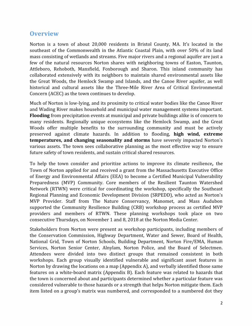
Areas of Concern
Several locations in town were identified as important strengths, notable vulnerabilities, and some could be considered a little of each. The four natural hazards identified by Norton workshop attendees included flooding, high wind, drought/fire/extreme temperatures, and changing seasonality. Infrastructure and resource disruptions are the outcomes attendees are most concerned about, especially considering the dependency on the Canoe River
Aquifer, the drinking water source for the five municipalities of Sharon, Foxborough, Mansfield, Easton and Norton. The Canoe River Aquifer is a Federally-designated Sole Source Aquifer due to its capacity to supply more than 50% of the drinking water consumed in the area, or approximately 50,000 residents. In total, the aquifer is 16 miles long and recharges the network of smaller aquifers that comprise the Canoe River sub watershed.
Prioritization (high, medium, low) and time anticipated to complete each action is indicated in the digitized matrices (Appendix C)
Infrastructure concerns were broad and deeply interconnected. Most items related
back to one or more of the following: water quality and quantity management, backup power systems, municipal/community buildings at risk of flooding, and issues surrounding the two main access routes (Route 123 and Route 140) through town. Specific features in these categories are named below:
Chart of days with temperatures over 90 degrees Fahrenheit in Norton, MA.

6
Vulnerability of existing infrastructure (e.g., telecommunication buildings, pump
stations, Norton Housing Authority) to power outages.
Walker Street, North Worcester Street, Plain Street, East Hodges Street culverts
Barrowsville, Chartley, and Norton Reservoir Dams
Neighborhoods vulnerable to power outages; Bay Road, homes around Winnecunnet Pond, 274 East Main Apartments, and Mobile Homes
Water and sewer pump stations
Municipal buildings, specifically Town Hall and all schools
Walkability of Route 123 and Route 140, current lack of pedestrian safety Both group’s discussions touched on a larger theme of infrastructure assessment needed for future adaptation, based on past challenges. The substation near the Norton Senior Center and
other power infrastructure has proven vulnerable to wind and storm events, which disrupted some families for a week in the winter of 2017-18.
Culverts were discussed as existing stormwater management infrastructure that needs assessment and upgrades. Multiple culverts need replacement to adequately manage the volume of water that frequently flows through them, and to avoid future damages to roads that are built over them.
Dams were identified as concerns for the downstream flooding and potential loss of life or property damage if they fail. They are not built to accommodate current water levels, and cannot be upgraded or removed without evaluating downstream impacts of different scenarios.
The Senior Center could alleviate the town’s need for more emergency shelters if it is made more resilient with a backup generator and flooding in the parking lot is mitigated. An option for flood management could be the installation of small bioretention areas- areas of green space and engineered soil layers to drain water – throughout the lot. With a backup generator for power outages, and new shingles to correct roof damage from previous storms, the Senior Center could be a reliable additional emergency shelter for Norton residents. Additionally, removing or leveling the back parking lot would allow for additional and safer parking during winter storms, and would be safer for pedestrians year-round.
Environmental concerns frequently related back to themes of either water quality or
preservation of ecosystems and their services. The opportunity to review municipal bylaws
and institutionalize Norton’s resilient development goals was also highlighted. Top environmental concerns include:
Wetlands and floodplain
Aquifer recharge and water quality maintenance
Forest management
Prioritizing resiliency to climate change while balancing new development
Siting solar developments on existing impervious surface
7
Large-scale solar is a compelling example of a simultaneous strength and vulnerability.
Participants cited concerns about the capacity for ensuring minimal tree cutting for solar siting, and do not want solar developments to be sited on forested lands for fear of compromising the many benefits forests provide. A prioritization of existing-impervious surfaces for new solar field developments was suggested.
Norton’s recent Large-Scale Ground-Mounted, Solar bylaw begins to address some of the above concerns and is an essential building block of the MVP Planning conversation. Participants recognized the importance of pairing an opportunistic application of Low Impact Development (LID) to manage stormwater on site as new projects and retrofits arise with the long-term approach of institutionalizing hazard-conscious zoning/design.
Existing solar farm sites experience flooding from runoff and consequential erosion,
especially where trees have been cleared. The existing Large-Scale Ground-Mounted Solar bylaw requires a storm water pollution prevention plan and specifies clearing ‘limited to what is necessary for construction’.
Societal concerns had breadth that included policy suggestions, vulnerable buildings,
and capacity changes to the town. Societal items that participants brought attention to included:
Adopt Community Preservation Act (CPA)
Transportation in emergencies
Communications within Norton
Information Technology capacity of the town
Multi-hazard Mitigation planning
Council on Aging
Wheaton College
Large dense housing area could lose cooling/warming without power, sewer injectors can go down also
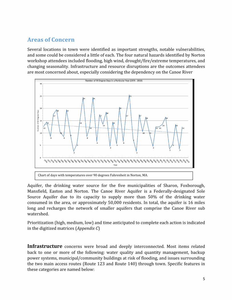
Bill Napolitano (SRPEDD) and Sara Burns (The Nature Conservancy) facilitate final prioritization of action items
8
Current Strengths and Assets
All of those in attendance generally agreed that recent changes to zoning bylaws to encourage Low Impact Development (LID) were a strength in Norton. Local and regional
conservation efforts have been steadfast in Norton over the years, and participants intend to continue the community’s track record. Ecosystem integrity is an imperative even as development evolves over time.
The town’s middle school was recognized as an invaluable asset, as it’s the only officially designated shelter. It is not located in areas vulnerable to flooding, and has a back-up generator. A secure public building and sound emergency management plan is crucial for any resilient community.
Many environmental features in Norton were named as strengths, and overlap with social assets:
Areas of Critical Environmental Concern, both the physical areas and the official
designations
The Great Woods Conservation Area
Record of preservation of conservation and historic open space
Recent changes to zoning bylaws that favor LID and local water conservation
Land Preservation Society of Norton for its environmental stewardship and leadership in maintaining public open space
Social services and community organizations are assets to Norton as well. Gathering places are critical for creating a sense of connectedness between residents, creating better quality
of life and stronger support networks in times of crisis. Social assets named by participants included:
St Mary/ St Vincent De Paul and their resources
YMCA as partner in public education, community space
Senior Center in its staff, connections, potential partner in public education and as a gathering space
A complete list of strengths and assets can be found in Appendix C in the digitized feature matrices.

9
Top Recommendations to Improve Resilience
Two days’ worth of discussion was whittled down into four thematic priorities that workshop participants agreed were urgent for Norton’s resilience (pictured above). Once actions were generated related to the list of strengths and vulnerabilities, each of the two groups identified their top three actions with their facilitator. The two groups then shared
their top themes, which overlapped organically. Facilitators then lead a discussion with all attendees to best incorporate each group’s suggestions into common themes.
Participants were encouraged to consider action items that mitigated hazards through strengthening natural systems and processes, and to complement technological or built fixes. An action that limits damage of natural hazards through conserving existing lands, integrating benefits of nature where they’re critically needed (e.g. flood storage, air quality
improvement) into ongoing construction, or restoring an ecosystem where it has been
disrupted is referred to as a Nature-based solution. Nature-based solutions (NBS) are a category of emerging strategies in climate adaptation and their exploration is of interest to the Commonwealth of Massachusetts as a national leader in comprehensive hazard mitigation. Effectively implementing NBS means designing a community whose built infrastructure is reinforced by its natural environment and vice versa.
The workshops’ four emergent themes included multi-hazard mitigation planning,
communications, stormwater management, and review of local bylaws. Ultimately the group named specific themes that need to be addressed through many incremental actions. These are the actions that participants rated as most urgent, and that the town anticipates executing as soon as possible:

10
Multi-Hazard Mitigation Planning
Add generators to the Norton Senior Center, St Mary’s, 120 West Main Apartment units, and homes around Winnecunnet Pond (or install adaptors on each Winnecunnet Pond home, so that a mobile generator can be used to service all the homes)
Designate additional emergency shelters, likely the Senior Center
Culvert replacement/upgrade at Walker, Plain, and East Hodges Streets
Assess all dams for, removal, maintenance costs/benefits
Stormwater Management retrofits and mitigation plans for Routes 123 and 140
Prioritize resiliency of Canoe River and Wading River, through improving infiltration, appropriate culvert replacement, and dam removal
Assess resilience of existing power infrastructure to treefall; coordinate with National Grid on their Vegetation Management Plan.
Communications
Create and distribute public education materials on local environmental resources
and vulnerabilities
Create an Information Technology department Collectively decide on/create a central social media account that will manage all communications to town – expand on school alerts and police notifications
Increase interdepartmental communication by collecting and sharing information
Stormwater Management
Incorporate LID in senior center parking lot
Keep local water local by improving infiltration and managing stormwater on-site
Bylaw Review
Revisit zoning, open space, subdivision bylaws to ensure nature-based solutions are being encouraged to their full capacity
Revisit Large-Scale Ground-Mounted Solar bylaw to encourage use of renewables while maintaining land conservation priorities
In making these recommendations, this cohort generated an array of potential actions that related back to the themes identified by facilitators. A complete list of actions generated by
the groups, along with their prioritization can be found in Appendix C. Many action items, both priority and general, were in alignment with the Norton Resiliency Roundtable Report completed in partnership with RTWN in 2016.

11
CRB Workshop Participants
Name Affiliation
Brad Bramwell Selectman
Jennifer Carlino Conservation Commission, Director
Keith Silver Highway Department, Superintendent
John Kyranos Alnylam
Stephen Desfosses Norton Police
Ray Cord Norton Emergency Management Agency
Bernie Marshall Norton Water and Sewer Superintendent
Chris Zahner Norton Board of Health, Agent
Donna Palmer Norton Board of Health, Public Health Nurse
Ann Malley National Grid
Wade Lizotte Town of Norton Schools
Joseph Baeta Town of Norton Schools, Superintendent
Michael Yunits Town of Norton, Town Manager
Paul DiGiuseppe Town of Norton Director of Planning and Economic Development
Chris Carmichael Building Department, Building Inspector
Paul J. Schleicher Norton Fire Chief/EMA
Beth Rossi Human Services/Senior Center, Director
Citation
Town of Norton (2018) Community Resilience Building Workshop Summary of Findings. Resilient Taunton Watershed Network. Norton, MA
Acknowledgements
The Norton Core Team and Facilitation Team would like to thank the following for their contributions to the MVP Workshop process: staff of the Norton Media Center for providing a wonderful meeting space, assistance with room set-up, and tech support; the Commonwealth of Massachusetts, EEA, Municipal Vulnerability Preparedness Program for their funding

12
support for these workshops, and; all of those who participated in the workshops and contributed to the plan resulting from these workshops.
Appendices show different methods of recording the same vulnerabilities and strengths
named by workshop participants through mapping and prioritized lists. Small groups
recorded infrastructural, environmental, and societal features in Norton and the hazard(s)
they to which relate. Each feature category (infrastructure, environment, society) was
documented on a separate matrix (see Appendix B and C for complete lists). On these short
lists, or matrices, action items were identified corresponding to each feature that was named.
Each action was then assigned a high, medium, or low priority value and expected short-term,
long-term, or ongoing time frame to complete.
To account for spatial relationships between features, participants simultaneously placed
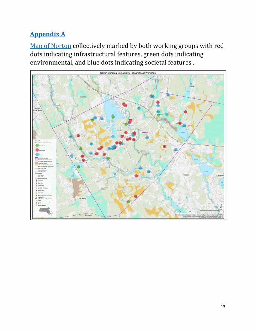
points on a map that corresponded to items they named on the different matrices. Infrastructural features are indicated with a red point, environmental with a green point, and societal with a blue point. Items on the map are also labeled for what they represent from the written list, but do not represent prioritization or associated action(s).
13
Appendix A
Map of Norton collectively marked by both working groups with red
dots indicating infrastructural features, green dots indicating
environmental, and blue dots indicating societal features .

14
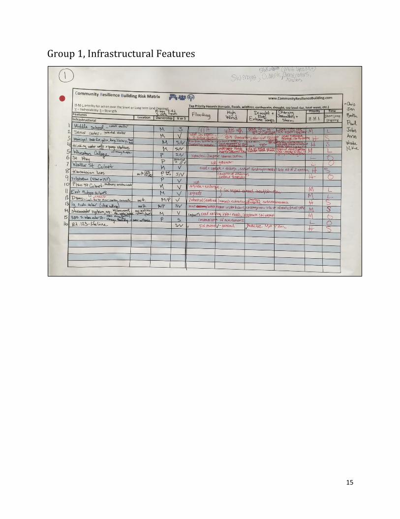
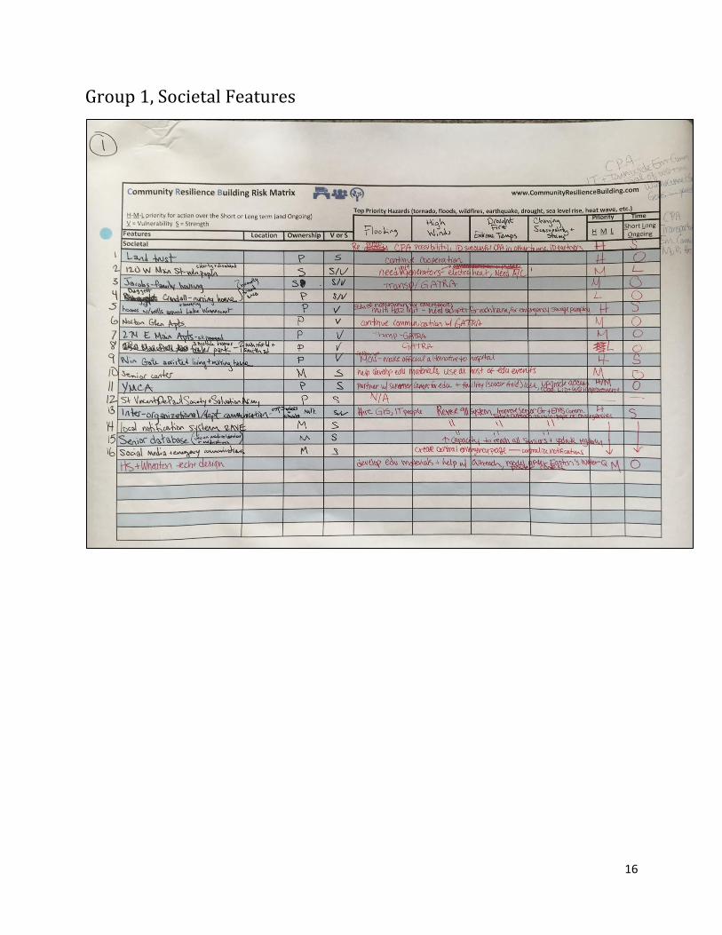
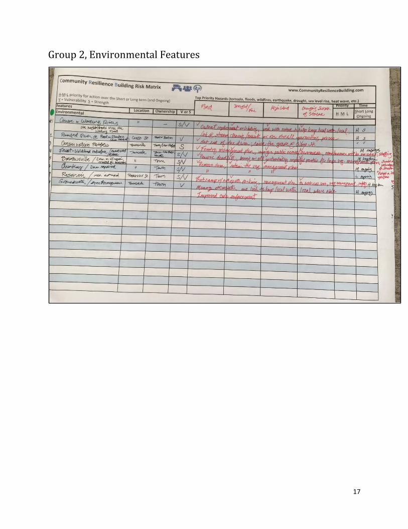
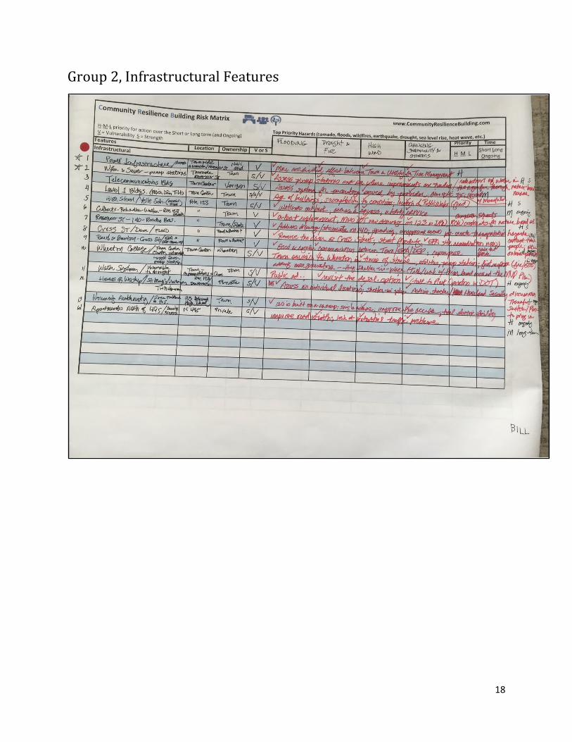
Appendix B
Photos of matrices used by each group to list features in town that
are impacted by natural hazards. Natural hazards of concern are
listed across the top, on the right side of the matrix. Feature names
and details are written in black ink. Action items and their prioritization are written in red ink.
Group 1, Environmental
15
Group 1, Infrastructural Features
16
Group 1, Societal Features
17
Group 2, Environmental Features
18
Group 2, Infrastructural Features

19
Group 2, Societal Features
20
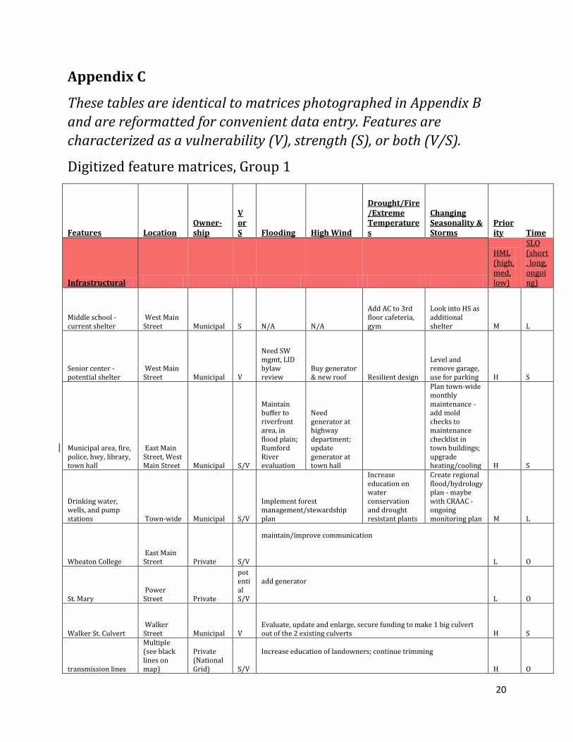
Appendix C
These tables are identical to matrices photographed in Appendix B
and are reformatted for convenient data entry. Features are
characterized as a vulnerability (V), strength (S), or both (V/S).
Digitized feature matrices, Group 1
Features Location Owner-ship
V or S Flooding High Wind
Drought/Fire/Extreme Temperatures
Changing Seasonality & Storms
Priority Time
Infrastructural
HML (high, med, low)
SLO (short, long, ongoing)
Middle school - current shelter
West Main Street Municipal S N/A N/A
Add AC to 3rd floor cafeteria, gym
Look into HS as additional shelter M L
Senior center - potential shelter
West Main Street Municipal V
Need SW mgmt, LID bylaw review
Buy generator & new roof Resilient design
Level and remove garage, use for parking H S
Municipal area, fire, police, hwy, library, town hall
East Main Street, West Main Street Municipal S/V
Maintain buffer to riverfront area, in flood plain; Rumford River evaluation
Need generator at highway department; update generator at town hall
Plan town-wide monthly maintenance - add mold checks to maintenance checklist in town buildings; upgrade heating/cooling H S
Drinking water, wells, and pump stations Town-wide Municipal S/V
Implement forest management/stewardship plan
Increase education on water conservation and drought resistant plants
Create regional flood/hydrology plan - maybe with CRAAC - ongoing monitoring plan M L
Wheaton College East Main Street Private S/V
maintain/improve communication L O
St. Mary Power Street Private
potential S/V
add generator L O
Walker St. Culvert Walker Street Municipal V
Evaluate, update and enlarge, secure funding to make 1 big culvert out of the 2 existing culverts H S
transmission lines
Multiple (see black lines on map)
Private (National Grid) S/V
Increase education of landowners; continue trimming H O
21
Substation (4kv ->13?) Private V
N/A
Plain St. culvert – Mulberry Meadow Brook Plain Street Municipal V
upgrade and enlarge culvert to manage stormwater on road, treat water and slow flow M L
East Hodges culvert
East Hodges Street Municipal V
upgrade -> SW mgmt on road, treat/slow flow M L
Dams (incl. Norton River & Cross St., Chartley, Barrowsville) Multiple
Municipal/Private V
Potential (evaluate) removal and restoration @ Barrowsville & Chartley, continue maintenance H S
Lg. scale solar (clear cutting) Multiple
Municipal /Private S/V
Keep water management in solar bylaws, encourage new solar on already paved sites to protect forests M S
Stormwater system, esp. Winnecunnet, etc. water bodies, Chartley
Muni ponds and SW systems (multiple) Municipal V
Update relevant bylaws. Evaluate existing infra and roads, incorporate stormwater management M O
380 S. Worcester St. - Mass casualty storage facility
MOU with town Private S
Communicate with new owners L O
Route 123 - lifeline Route 123 State S/V General stormwater management Multi-Hazard Mitigation plan H S
Environmental
Canoe River Sole Source Aquifer Regional
Multiple Municipal Owner-ship S/V
Regional Plan
Education for the public; revisit water budget; get Water Department Meeting and Drought Plan M O
Forest Cover Town-wide Municipal/Private S/V
Budget for Hazard Tree removal
Continue Implementing Forest Management Plan; Outreach for updated Forest Management Plan volunteers H O
Wetlands and floodplains Town-wide
Municipal/Private S/V
Bylaw review - protect wetlands and floodplains, encourage infiltration on site, public education via social media materials H O
ACEC - Hockomock, Canoe River, Three Mile, Greenbelt project Multiple
Municipal/State S
Bylaw Review to protect open space, evaluate existing open space, continue Open Space Plan implementation and Greenbelt plans M O
Great Woods - historic, cultural, archaeological, and OS
Great Woods
Municipal/State S
Develop Forest Management Plan and include these features L L
22
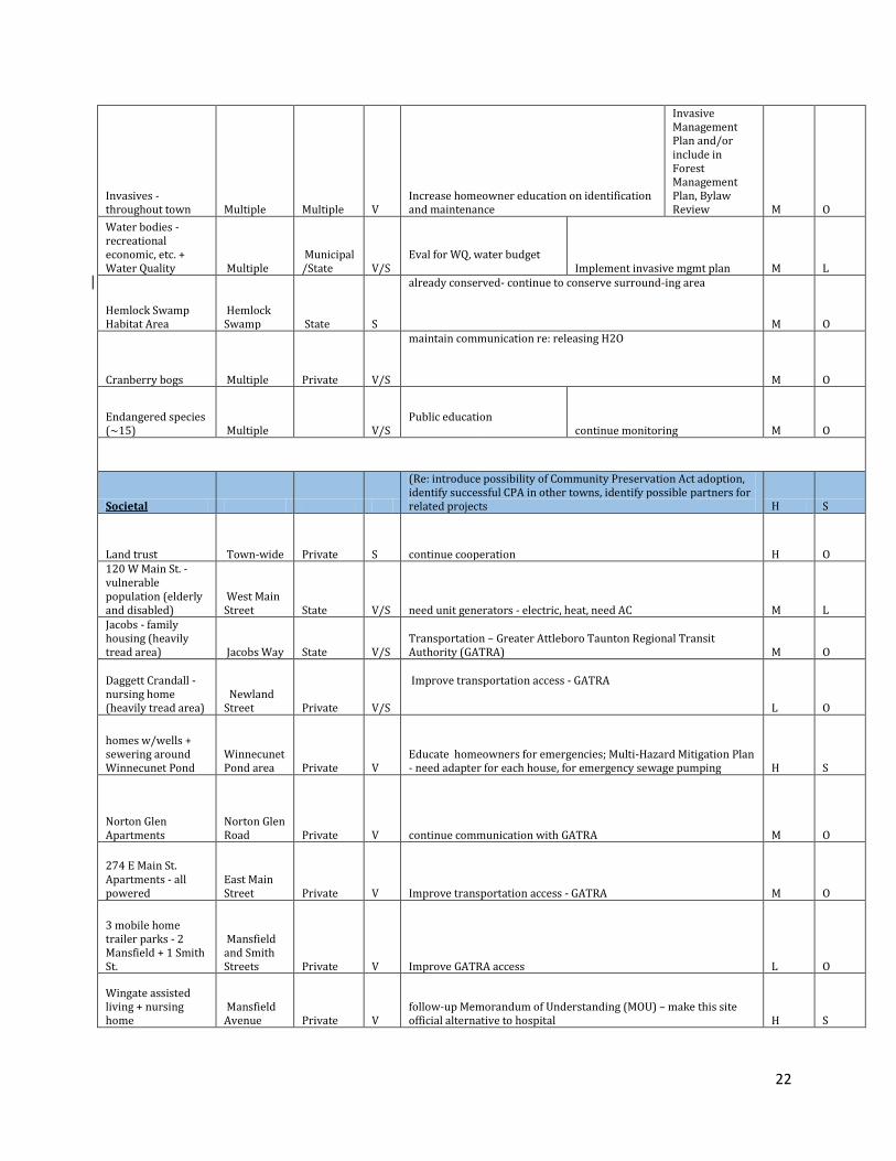
Invasives - throughout town Multiple Multiple V
Increase homeowner education on identification and maintenance
Invasive Management Plan and/or include in Forest Management Plan, Bylaw Review M O
Water bodies - recreational economic, etc. + Water Quality Multiple
Municipal/State V/S
Eval for WQ, water budget
Implement invasive mgmt plan M L
Hemlock Swamp Habitat Area
Hemlock Swamp State S
already conserved- continue to conserve surround-ing area M O
Cranberry bogs Multiple Private V/S
maintain communication re: releasing H2O M O
Endangered species (~15) Multiple V/S
Public education
continue monitoring M O
Societal
(Re: introduce possibility of Community Preservation Act adoption, identify successful CPA in other towns, identify possible partners for related projects H S
Land trust Town-wide Private S continue cooperation H O 120 W Main St. - vulnerable population (elderly and disabled)
West Main Street State V/S need unit generators - electric, heat, need AC M L
Jacobs - family housing (heavily tread area) Jacobs Way State V/S
Transportation – Greater Attleboro Taunton Regional Transit Authority (GATRA) M O
Daggett Crandall - nursing home (heavily tread area)
Newland Street Private V/S
Improve transportation access - GATRA L O
homes w/wells + sewering around Winnecunet Pond
Winnecunet Pond area Private V
Educate homeowners for emergencies; Multi-Hazard Mitigation Plan - need adapter for each house, for emergency sewage pumping H S
Norton Glen Apartments
Norton Glen Road Private V continue communication with GATRA M O
274 E Main St. Apartments - all powered
East Main Street Private V Improve transportation access - GATRA M O
3 mobile home trailer parks - 2 Mansfield + 1 Smith St.
Mansfield and Smith Streets Private V Improve GATRA access L O
Wingate assisted living + nursing home
Mansfield Avenue Private V
follow-up Memorandum of Understanding (MOU) – make this site official alternative to hospital H S
23
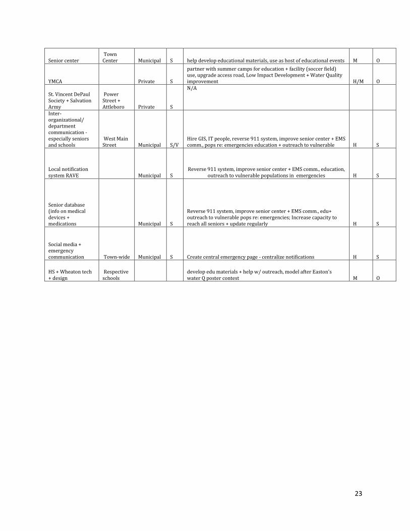
Senior center Town Center Municipal S help develop educational materials, use as host of educational events M O
YMCA Private S
partner with summer camps for education + facility (soccer field) use, upgrade access road, Low Impact Development + Water Quality improvement H/M O
St. Vincent DePaul Society + Salvation Army
Power Street + Attleboro Private S
N/A
Inter-organizational/ department communication - especially seniors and schools
West Main Street Municipal S/V
Hire GIS, IT people, reverse 911 system, improve senior center + EMS comm., pops re: emergencies education + outreach to vulnerable H S
Local notification system RAVE Municipal S
Reverse 911 system, improve senior center + EMS comm., education,
outreach to vulnerable populations in emergencies H S
Senior database (info on medical devices + medications Municipal S
Reverse 911 system, improve senior center + EMS comm., edu+ outreach to vulnerable pops re: emergencies; Increase capacity to reach all seniors + update regularly H S
Social media + emergency communication Town-wide Municipal S
Create central emergency page - centralize notifications H S
HS + Wheaton tech + design
Respective schools
develop edu materials + help w/ outreach, model after Easton's water Q poster contest M O
24
Digitized Feature Matrices, Group 2
Features Location Owner-ship
V or S
Flooding, Drought & Fire, High Wind, Changing Seasonality & Storms
Priority Time
Infrastructural
HML (high, med, low)
SLO (short, long, ongoing)
Power infrastructure/access
Town-wide: N. Worcester/Reservoir St. Nat'l Grid V
Moore coordinated effort between town and utility for tree management H
Water and sewer - pump stations Town-wide: Reservoir St. Town
S/V
Assess pump stations and see where improvements are needed/retention of water in the aquifer through nature-based means H S
Telecommunications Building Town Center Verizon
S/V
Assess system for percentage served by provider; fiber optic sys.; regional w/ Mansfield M
Level 1 Buildings (police, fire, T.H.) Town Center Town
V/S
Age of buildings; susceptibility to conditions; location of Public Works (flood) H S
High school/Yelle School (access field) Route 123 Town
V/S
Wetlands out back; access and egress; utility service M O
Culverts - Richardson - Walker - Route 123 (flood)
Route 123 at Richardson Street, Route 123 at Walker Street Town V
culvert replacement; MassDOT new drainage on 123 @ DPW; ROW constraints for nature-based solutions; complete streets H S
Reservoir St - 140 - Roche Bros. Reservoir Street Town/state V
Address drainage/stormwater on 140; speeding; unimproved access points create transportation hazards; contact these people; alter online/print M-H L
Cross Street Dam/Flood area Cross Street
Reed & Barton V
Remove the dam @ Cross Street; street flooding; EPA site remediation now H S
Reed & Barton - Cross St/EPA + DEP clean-up Cross Street
Reed & Barton V
Good & regular communication between Town/EPA/DEP; repurpose H O
Wheaton College/Town Center; cluster vulnerable largest sewer pump station Town center Wheaton
V/S
Communicate MVP Plan to Wheaton. Town deviates to Wheaton in times of stress; utilities, pump station; first responder (fire/EMS) adding more generators - they shelter-in-place L O
Water system - vulnerable to drought Town - 4 pump stations Town
V/S
Public ed.; revisit the desalination option; (talk to plant operators + DOT) H O
25
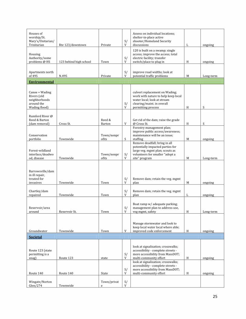
Houses of worship/St. Mary's/Unitarian/Trinitarian Rte 123/downtown Private
S/V
Assess on individual locations; shelter-in-place active shooter/Homeland Security discussions L ongoing
Housing Authority/some problems @ HS 123 behind high school Town
S/V
120 is built on a swamp; single access; improve the access; total electric facility; transfer switch/place to plug in H ongoing
Apartments north of 495 N.495 Private
S/V
improve road widths; look at potential traffic problems M Long-term
Environmental
Canoe + Wading Rivers (old neighborhoods around the Wading flood)
S/V
culvert replacement on Wading; work with nature to help keep local water local; look at stream clearing/maint. in overall permitting process H S
Rumford River @ Reed & Barton (dam removal) Cross St.
Reed & Barton V
Get rid of the dam; raise the grade @ Cross St. H S
Conservation portfolio Townwide
Town/nonprofits S
Forestry management plan; improve public access/awareness; maintenance will be an issue; staffing M ongoing
Forest-wildland interface/deadwood, disease Townwide
Town/nonprofits
S/V
Remove deadfall; bring in all potentially impacted parties for large veg. mgmt plan; scouts as volunteers for smaller "adopt a site" program M Long-term
Barrowsville/dam in ill repair, treated for invasives Townwide Town
S/V
Remove dam; retain the veg. mgmt plan M ongoing
Chartley/dam repaired Townwide Town
S/V
Remove dam; retain the veg. mgmt plan L ongoing
Reservoir/area around Reservoir St. Town
S/V
Boat ramp w/ adequate parking; management plan to address use, veg mgmt, safety H Long-term
Groundwater Townwide Town V
Manage stormwater and look to keep local water local where able; improved code enforcement H ongoing
Societal
Route 123 (state permitting is a snag) Route 123 state
S/V
look at signalization; crosswalks; accessibility - complete streets - more accessibility from MassDOT; multi-community effort H ongoing
Route 140 Route 140 State S/V
look at signalization; crosswalks; accessibility - complete streets - more accessibility from MassDOT; multi-community effort H ongoing
Wingate/Norton Glen/274 Townwide
Town/private
S/V

26
Senior Center/120 West Main/Red Mill
S/V
Bring resiliency education to these facilities; employ ACT team more widely L-M ongoing
Great Brook/Dagett-Crandall
S/V
promote public safety (make sure you adequate staff and budget)
4 schools on Rte 123 (all on West Main): 1 on Rte 140 - Legacy Christian; L.G. Norse on Plain St. Townwide
Town (except Legacy Christian which is private)
S/V
All have special needs populations; Yelle School in particular; we have to address our ability to meet the needs; de-escalate; work w/ state reps on this H S & ongoing
North Cottage (rehab & prisoners) access from Town Hall DPH
S/V
All have special needs populations; we have to address our ability to meet the needs; de-escalate; work w/ state reps on this; KNOW WHERE THESE POPULATIONS ARE H S & ongoing
Judge Rotenburg Center (2)
Shelly Road by 495 overpass Private
S/V
All have special needs populations; we have to address our ability to
meet the needs; de-escalate; work w/ state reps on this; KNOW
WHERE THESE POPULATIONS ARE H S & ongoing
N. Worcester St. Shelly Road by 495 overpass Private
S/V
All have special needs populations; we have to address our ability to
meet the needs; de-escalate; work w/ state reps on this; KNOW
WHERE THESE POPULATIONS ARE H S & ongoing
CCBC West Main Private S/V
All have special needs populations; we have to address our ability to
meet the needs; de-escalate; work w/ state reps on this; KNOW
WHERE THESE POPULATIONS ARE H S & ongoing
Industrial Park Commerce Drive/Way Private S/V
Look at the layout; accessibility; traffic issues; first responder issues M S
Industrial Park Leonard St. Private S/V
Look at the layout; accessibility; traffic issues; first responder issues M S
Constantly work together to review bylaws/regs/ policies Town S Retain this approach H ongoing
First response calls to schools and Wheaton (big increases for past several years) Townwide various
S/V
Keep good lines of communication + training open M ongoing


![David Hume [David Fate Norton, Mary J. Norton]](https://img.pdfslide.us/doc/110x75/5695d4c71a28ab9b02a2baa7/david-hume-david-fate-norton-mary-j-norton.jpg)