Embed Size (px)
Citation preview
Version 7 August 2009
Northern Victoria Irrigation Renewal Project
Wetland Short-listing Report
i
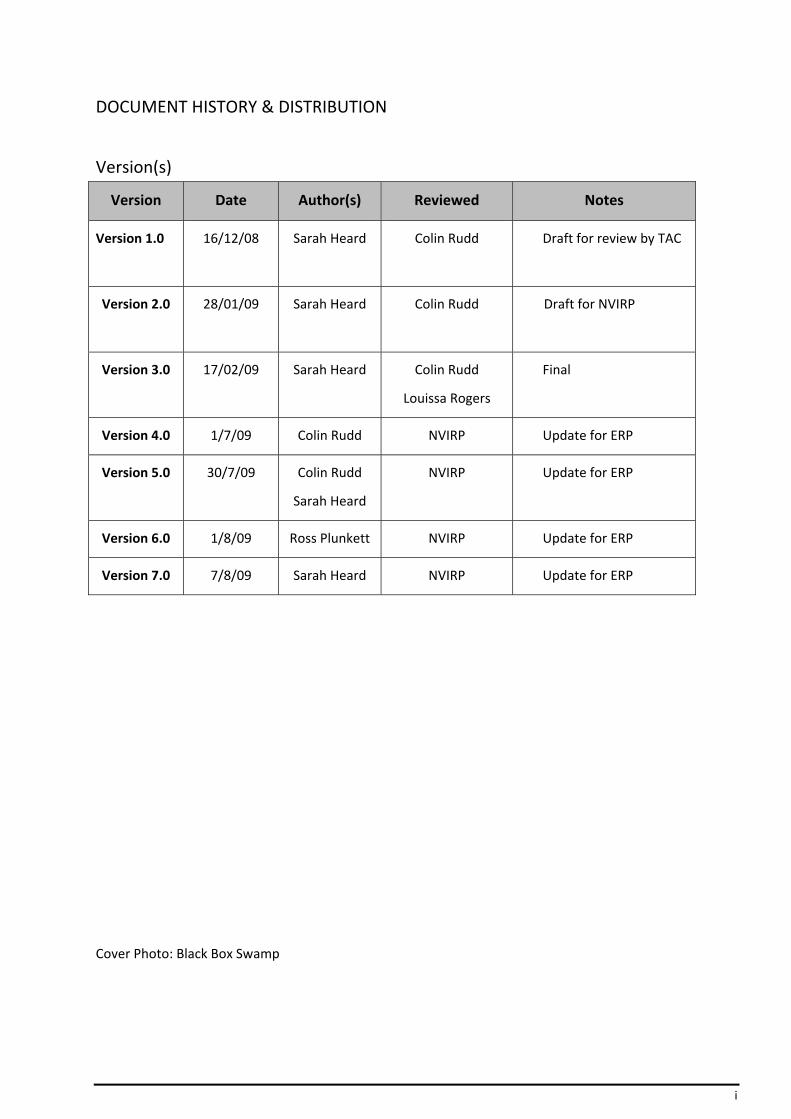
DOCUMENT HISTORY & DISTRIBUTION
Version(s)
Version Date Author(s) Reviewed Notes
Version 1.0 16/12/08 Sarah Heard
Colin Rudd Draft for review by TAC
Version 2.0 28/01/09 Sarah Heard
Colin Rudd Draft for NVIRP
Version 3.0 17/02/09 Sarah Heard
Colin Rudd
Louissa Rogers
Final
Version 4.0 1/7/09 Colin Rudd NVIRP Update for ERP
Version 5.0 30/7/09 Colin Rudd
Sarah Heard
NVIRP Update for ERP
Version 6.0 1/8/09 Ross Plunkett NVIRP Update for ERP
Version 7.0 7/8/09 Sarah Heard NVIRP Update for ERP
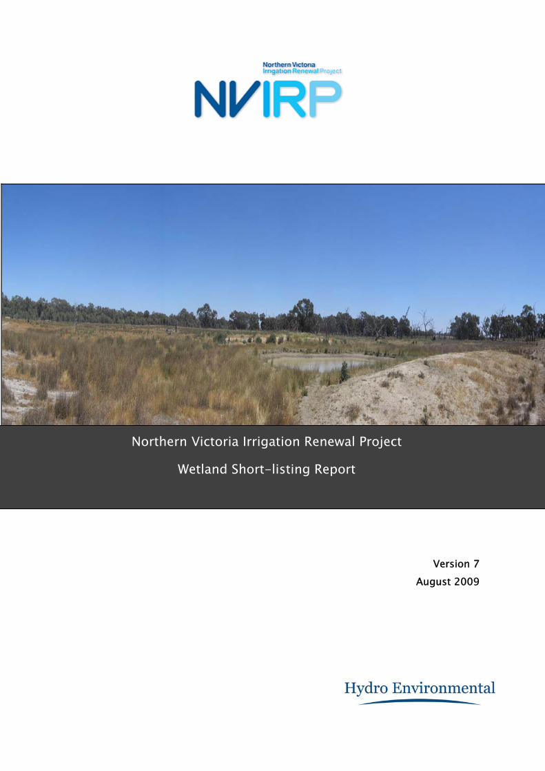
Cover Photo: Black Box Swamp

ii
Table of Contents
1 Introduction ........................................................................................................................... 1
1.1 Purpose ................................................................................................................................... 1
1.2 Water Change Management Framework ............................................................................... 1
1.3 Methodology ........................................................................................................................... 1
1.4 Aspects not addressed in this Report ...................................................................................... 1
1.5 Outcomes from this Report ..................................................................................................... 2
2 Background ............................................................................................................................ 3
2.1 Impact of Irrigation on Wetlands in the GMID ....................................................................... 3
2.2 Recent impacts ........................................................................................................................ 3
3 Northern Victoria Irrigation Renewal Project .......................................................................... 5
3.1 The Project .............................................................................................................................. 5
3.2 Project Principles ..................................................................................................................... 5
3.3 Location ................................................................................................................................... 6
3.4 Impact of NVIRP on Wetland Water Supply ............................................................................ 7
4 Methodology ......................................................................................................................... 10
4.1 Preliminary List of Wetlands ................................................................................................. 10
4.2 Wetland Validation and Short‐listing .................................................................................... 14
4.3 Environmental Watering Plans ............................................................................................. 16
5 Outcomes of Wetlands Validation ......................................................................................... 17
5.1 Lake Elizabeth ....................................................................................................................... 17
5.2 Hunt’s Swamp ....................................................................................................................... 18
5.3 Dunn’s Swamp ....................................................................................................................... 19
5.4 Thunder Swamp .................................................................................................................... 19
5.5 Black Box Swamp .................................................................................................................. 20
5.6 Wharparilla Flora Reserve ..................................................................................................... 21
5.7 Richardson’s Lagoon ............................................................................................................. 22
5.8 Murphy’s Swamp .................................................................................................................. 23
5.9 Johnson Swamp ..................................................................................................................... 24
5.10 Round Lake (near Lake Boga) ................................................................................................ 24
5.11 Bray’s Swamp (310694) ........................................................................................................ 25
5.12 Bray’s Swamp (313709) ........................................................................................................ 26
5.13 Merrigum Swamp ................................................................................................................. 27
5.14 Lake Yando ............................................................................................................................ 28
5.15 Lake Leaghur ......................................................................................................................... 28
5.16 Lake Meran ........................................................................................................................... 29
5.17 Little Lake Meran .................................................................................................................. 29
5.18 Lake Murphy ......................................................................................................................... 30
5.19 McDonalds Swamp................................................................................................................ 31
5.20 Golf Course (Tresco) Lake ...................................................................................................... 32
5.21 Little Lake Boort .................................................................................................................... 33
5.22 Little Wallenjoe Swamp ........................................................................................................ 33

iii
5.23 Kanyapella Basin ................................................................................................................... 34
5.24 Kinnairds Swamp ................................................................................................................... 35
6 Reconciliation with Desktop Assessment (SKM, 2008) Outcomes .......................................... 37
6.1 Desktop Assessment (SKM, 2008) and NVIRP Outcome Comparison ................................... 37
7 Summary ............................................................................................................................... 40
7.1 Short‐list of Wetlands Impacted by Reduced Outfall ............................................................ 40
7.2 Schedule of EWP Development ............................................................................................. 40
7.3 Wetlands Not Impacted by Reduced Outfall ......................................................................... 40
8 Recommendation .................................................................................................................. 42
9 Glossary of Terminology ........................................................................................................ 43
10 References ......................................................................................................................... 47
11 Appendix 1 Validation and Scheduling of Wetlands Requiring EWPs .................................. 48
12 Appendix 2 Data Sheets ..................................................................................................... 51
13 Appendix 3 Reconciliation with Desktop Assessment (SKM, 2008) ..................................... 81
14 Appendix 4 NVIRP Program ............................................................................................... 93

1
1 Introduction
1.1 Purpose
The purpose of the Wetland Short‐listing Report is to validate and confirm the existing sources of water for the identified preliminary list (Desktop Assessment, SKM, 2008) of wetlands in the Goulburn – Murray Irrigation District (GMID). These wetlands have been identified in the Desktop Assessment (SKM, 2008) as having high environmental values and receiving incidental irrigation water from outfalls which will be reduced by modernisation.
Wetlands where significant impacts are likely and validated were recommended for further, more detailed investigation, or the development of an Environmental Watering Plan (EWP).
This validation, short‐listing and scheduling of wetlands requiring EWPs has been undertaken in accordance with Northern Victoria Irrigation Renewal Project’s (NVIRP) Water Change Management Framework (WCMF) (NVIRP, 2009).
1.2 Water Change Management Framework
The WCMF provides the framework for protection of aquatic and riparian ecological values through management of water allocations and flows within the modified GMID system, including procedures for monitoring, reporting and auditing changes in hydrological and ecological conditions in relevant waterways or wetlands associated with the project’s operation. It provides the environmental commitments, processes and methodologies for the relevant operations of the modified system.
In particular, the WCMF addresses the requirements of Condition 3 of the Minister for Planning’s decision that an Environment Effects Statement (EES) is not required for the NVIRP project, as described in the referral accepted on 20 February 2009.
The WCMF stipulates that a short‐list of wetlands requiring EWP’s be prepared that includes:
• specification of whether the 17 ‘at risk’ wetlands listed in Attachment A of the Minister’s decision require an EWP or not.
• rationale for those sites requiring EWPs.
• a schedule for development of EWPs, in relation to implementation of NVIRP’s program of works.
A copy of the methodology for validating, short‐listing and scheduling wetlands requiring an EWP outlined in the WCMF is provided in Appendix 1.
1.3 Methodology
A three step process was used to confirm the source(s) of water supply to the identified wetlands that may be potentially impacted as a result of the NVIRP. The process involved the following steps:
1. Site Inspection and collation of data to confirm source(s) of water supply to the wetland 2. Analysis of data collated and confirmation of the wetlands which receive water from
incidental irrigation water from channel outfalls 3. Identification requirement and scheduling for development of EWPs
1.4 Aspects not addressed in this Report
This Report does not consider:

2
• Timing or water quality impacts that may result from hydrologic changes of water supply. Where wetlands are confirmed likely to receive incidental outfall water, these impacts will be considered during development of the EWP.
• Impact to wetlands due to reductions in groundwater recharge through reduction of leakage and seepage from channels and farm efficiency improvements as these will be considered within the Regional Groundwater Assessment Report.
• Wetlands other than those on the preliminary list of wetlands.
• Environmental values identified in Desktop Assessment (SKM, 2008).
1.5 Outcomes from this Report
This Report documents the outcomes of the assessment, confirming the current sources of water supply to the preliminary list of 24 wetlands in the GMID identified areas and validating that the listed wetlands do receive incidental irrigation water from outfalls direct from channels or from irrigation drains.
Confirmation of water supply to the preliminary list of wetlands involved an analysis of the wetlands using information obtained from a ground‐truthing exercise of the 24 listed wetlands, available literature and consultation with relevant stakeholders.
Where a site with high environmental values could be adversely affected due to the changed irrigation water contribution by the implementation of NVIRP, a recommendation will be that an EWP will be prepared.
Where it is determined that the removal of incidental irrigation water from a wetland is beneficial or will not have a significant impact, then it is recommended that NVIRP is not required to prepare an EWP.
The Report recommends a short‐list of wetlands that require the development of an EWP and the scheduling of the wetlands EWP development.
3
2 Background
2.1 Impact of Irrigation on Wetlands in the GMID
Over the last century, the development and operation of the irrigation system throughout the GMID area has variously affected the water regimes of wetlands throughout the GMID. Many wetlands throughout the GMID have a history of receiving excess water from the irrigation system (irrigation water) resulting from manual operation or system shutdown following rainfall, either direct from channel outfalls or from drains.
Elevated groundwater levels due to the application of irrigation water have also increased the permanency and salinity of water in a number of wetlands. In some cases the contribution of irrigation water represents additional water, which increases the depth, frequency and duration of wetland inundation. Irrigation water may now be the principle source of water rather than natural flood water that no longer reaches particular wetlands because of river regulation, artificial drains, levee banks, works associated with the irrigation system, other infrastructure and agricultural activities. Irrigation operations have also affected the timing of water delivery to wetlands with high inputs occurring during summer, when wetlands would naturally receive very little water.
Not all of the wetlands in the GMID receive substantial amounts of irrigation water. The water regime in some wetlands is relatively unaltered compared with natural. However, wetlands that receive little or no irrigation water are much drier than they would have naturally been because irrigation development in the region has reduced the frequency and duration of natural flooding and also altered pathways for natural rainfall run‐off.
The construction and operation of the irrigation system has had significant consequences for the wetting patterns of the wetlands in the GMID. These impacts include:
• Less flooding in the winter/spring period due to river regulation; and
• Changes to the flow to wetlands due to original drainage lines being intercepted by irrigation infrastructure.
Many of the wetlands in the GMID now rely on irrigation infrastructure as a means of receiving water, just as the irrigation system relies on natural carriers and wetlands as part of their water delivery system. In some cases, the timing, volume and/or quality of water entering wetlands from the irrigation system may not be suitable for the environmental values of that wetland. In other cases, particularly where natural wetting regimes have largely ceased or new wetland values have developed, the water entering the wetland from the irrigation infrastructure may sustain high environmental values.
2.2 Recent impacts
In more recent times, the wetlands of the GMID have also been significantly impacted by the reduction in the total volume of outfalls from irrigation channels as a result of the combined effects of water quality and irrigation system efficiency improvement strategies, other modernisation projects and drought.
Various salinity and nutrient management initiatives have been underway since the mid 1980’s. Since the late 1990’s, improved operation of the irrigation systems and better customer ordering arrangements have been in place to minimise losses and ensure more efficient water delivery.
There are also currently a number of factors that are affecting the volume of quality incidental irrigation water that arrives in wetlands, namely:
4
• salinity initiatives;
• nutrient reduction initiatives;
• water trade;
• drought and potential risk of climate change;
• Goulburn‐Murray Water loss reduction program;
• Strategic Measurement Project;
• irrigation modernisation projects; and
• Commonwealth Government water purchase.
These factors and the Victorian and Commonwealth Governments’ policy responses and initiatives to address the issues are discussed further in the WCMF (NVIRP, 2009).
These factors predate the development and implementation of NVIRP and may have affected some of the high environmental values that are associated with individual wetlands in the GMID. Separating the effect of the NVIRP from drought and previous outfall reduction strategies is difficult with the available outfall information (which does not specifically relate to the last five years). This contributes to the uncertainty associated with the environmental assessment1.
1 SKM (2008). Food Bowl Modernisation Project –Environmental Referrals

5
3 Northern Victoria Irrigation Renewal Project
3.1 The Project
The NVIRP is a $2 billion works program to upgrade ageing irrigation infrastructure across the GMID and to save water lost through leakage, evaporation and system inefficiencies. Works will include lining and automating channels, building pipelines and installing new, modern metering technology. These combined works will improve the irrigation system’s delivery efficiency and recover an average 425 GL of water per year.
The project is to be conducted in two stages across a period in the order of five to eight years.
Stage 1 involves the installation of new gates in regulators and system automation and landholder meters to improve the efficiency and measurement of water allocation, channel remediation on the backbone channels in the form of lining to prevent seepage and leakage together with the connection of landholder works back to the backbone which could include repair, replacement or upgrading and some rationalisation of existing channels (potentially including some new piping), to reduce leakage, seepage and evaporation of irrigation water.
Stage 2 focuses on reconfiguration and rationalisation of channels and farm outlets in the form of landholder connections to reduce leakage, seepage and evaporation, including replacing channels with pipes where appropriate and further channel remediation on the backbone channels in the form of lining to prevent seepage and leakage.
The GMID uses a number of natural carriers, rivers, lakes and wetlands for both storage and conveyance of water. While the water savings generated from the NVIRP is considered a ‘loss’ to the irrigation system, in some cases this operating regime provides incidental benefits to environmental assets.
3.2 Project Principles
As set out in the Water Savings Framework for the Northern Victoria Irrigation Renewal Project prepared by DSE, the overarching principles with respect to environmental management for NVIRP are:
• NVIRP will strive for efficiency in both water supply and farm watering systems.
• NVIRP will design and construct the modernised GMID system to comply with environmental requirements as specified in the no‐EES conditions.
• NVIRP will develop management and mitigation measures consistent with established environmental policies and programs in place in the GMID.
• Renewal or refurbishment of water infrastructure will be undertaken to the current best environmental practice, including any requirements to better provide environmental water. Best environmental practice will require irrigation infrastructure required to deliver environmental water to be retained (no rationalisation at these sites) or upgraded to allow for future use.
• Management and mitigation measures will be maintained into the future through establishment of or modification to operating protocols and operational arrangements.
A WCMF has been developed to assess, manage and mitigate the effects of the implementation of the NVIRP on aquatic and riparian ecological values within the GMID area. The following additional principles were designed as part of the WCMF to guide how the principles outlined in the Water Savings Framework for the Northern Victoria Irrigation Renewal Project will be applied.
6
• NVIRP will adopt a risk management approach and will aim to
o Avoid and mitigate the adverse effects of NVIRP’s implementation on high environmental values associated with wetlands and waterways
o Avoid adverse effects on other environmental values where practicable o Retain infrastructure, and improving it where practicable, where it will be required
for delivering environmental water by others, either now or in the future
• NVIRP will actively seek to coordinate with relevant agencies to identify and assess impacts and to deliver effective management and mitigation measures.
• NVIRP will consult with relevant environment and land managers to identify infrastructure requirements for environmental watering.
• NVIRP will adopt an adaptive management approach (assess, design, implement, monitor, evaluate and adjust) to ensure that it is responsive to changing conditions.
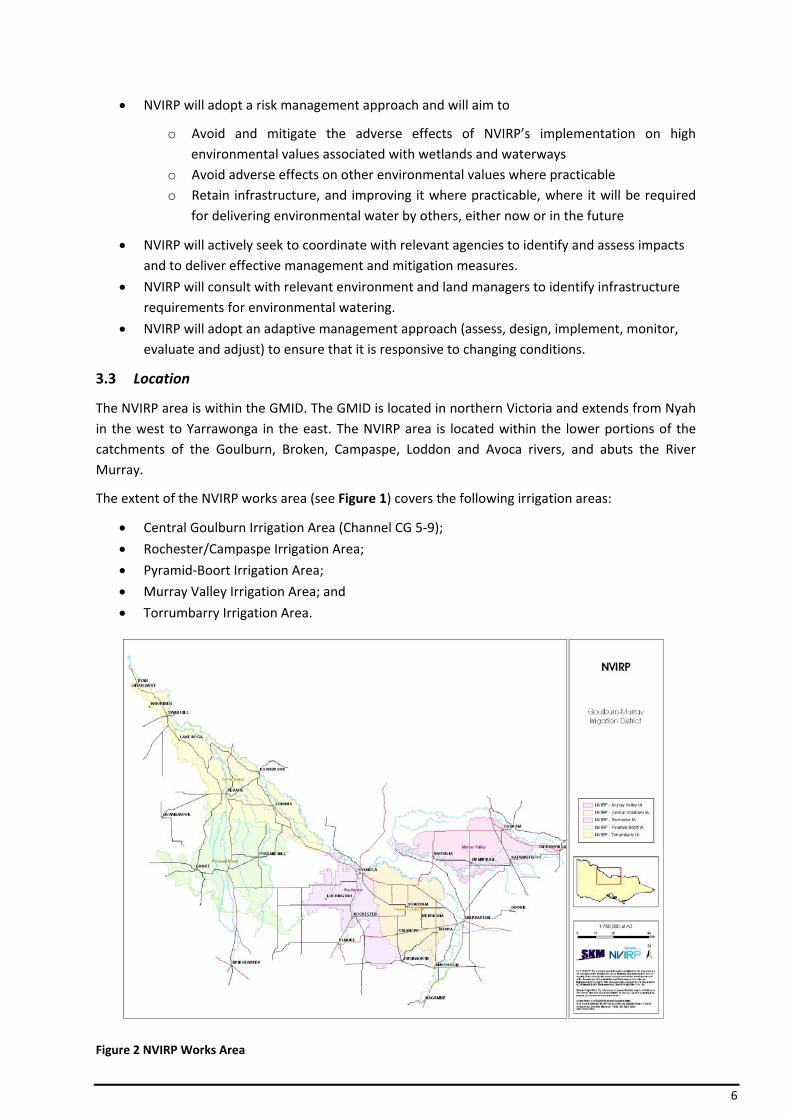
3.3 Location
The NVIRP area is within the GMID. The GMID is located in northern Victoria and extends from Nyah in the west to Yarrawonga in the east. The NVIRP area is located within the lower portions of the catchments of the Goulburn, Broken, Campaspe, Loddon and Avoca rivers, and abuts the River Murray.
The extent of the NVIRP works area (see Figure 1) covers the following irrigation areas:
• Central Goulburn Irrigation Area (Channel CG 5‐9);
• Rochester/Campaspe Irrigation Area;
• Pyramid‐Boort Irrigation Area;
• Murray Valley Irrigation Area; and
• Torrumbarry Irrigation Area.
Figure 2 NVIRP Works Area
7
3.4 Impact of NVIRP on Wetland Water Supply
One of the specific targets of the NVIRP is to reduce channel outfalls by 85%. Improved channel metering, repairs to leaky channels and more efficient application of irrigation water on farms are also planned with the aim of reducing surface run‐off and contributions to groundwater. This process of modernisation has the potential to have significant impacts on the wetlands of the GMID and their water regimes.
NVIRP will reduce incidental spillage of water from channels to wetlands. Some of this “lost” water may have provided environmental benefits. Reducing these losses may have local (within the irrigation system) and regional environmental impacts due to less flow into drainage systems and associated wetlands, and changes in water quality, including salinity.
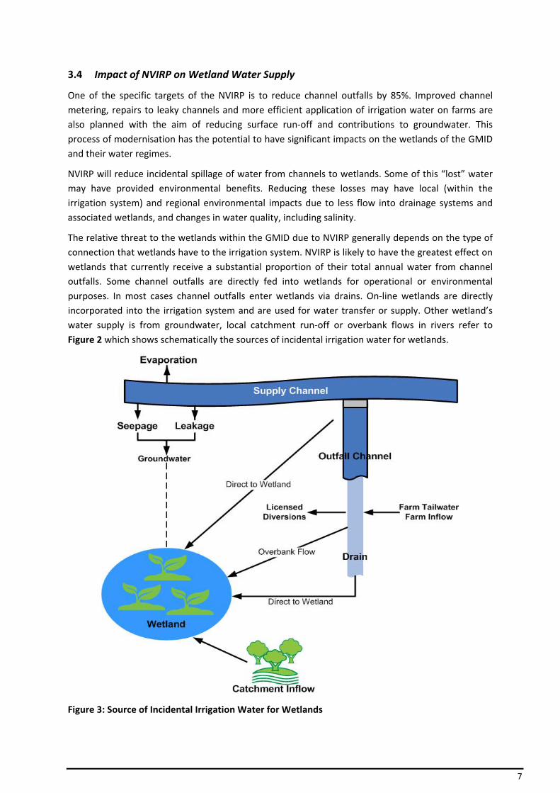
The relative threat to the wetlands within the GMID due to NVIRP generally depends on the type of connection that wetlands have to the irrigation system. NVIRP is likely to have the greatest effect on wetlands that currently receive a substantial proportion of their total annual water from channel outfalls. Some channel outfalls are directly fed into wetlands for operational or environmental purposes. In most cases channel outfalls enter wetlands via drains. On‐line wetlands are directly incorporated into the irrigation system and are used for water transfer or supply. Other wetland’s water supply is from groundwater, local catchment run‐off or overbank flows in rivers refer to Figure 2 which shows schematically the sources of incidental irrigation water for wetlands.
Figure 3: Source of Incidental Irrigation Water for Wetlands
8
Channel (Direct Outfall)
The water regime in wetlands that receive direct outfalls from an irrigation channel may have been substantially altered by the operation of the existing irrigation system. They receive extra water during the irrigation season, whilst river regulation and construction of levees and drains may have substantially reduced winter and spring inflows to these wetlands.
NVIRP is likely to result in a substantial reduction to incidental outfall water during the irrigation season. Water supply at other times is unlikely to be affected. Wetlands will be much drier during the irrigation season and if channel outfalls are compensating for less frequent inundation in winter then wetlands will also be drier than the natural water regime in winter.
Drains
Many irrigation channel outfall flows enter drains that ultimately return water to natural rivers and streams. These drains are often constructed, and follow natural drainage lines and depressions and regularly carry water to wetlands.
Wetlands may be connected to irrigation drains in one of three ways:
• wetlands that are part of the drainage system and fill incrementally as flow increases through the drain;
• drain cuts through a wetland in a natural depression, inundated when the drain spills; and
• wetland is part of a meander in a natural depression that has been by‐passed by a constructed irrigation drain, inundated when the drain spills.
Wetlands that receive water directly from irrigation drains may receive increased water during the irrigation season, but the drains also carry local catchment run‐off and therefore the wetlands are likely to receive higher inflows during natural rain events throughout the year.
A drains capacity is designed to cater for high flow events generated from catchment runoff following a rainfall event. Operational outfalls tend to be relatively small when compared to a drain’s design capacity and would remain in the drain. Rainfall rejection from channels usually ceases within hours of a rainfall event starting and the outfall volume is restricted by the channel outfall structure’s capacity, whilst rainfall run‐off from the drain catchment tends to take longer to enter the drain and increases drain flow.
Many of the drains have structures within the waterway that can be shut to allow high flows in drains to overflow into the wetlands. The older drains tend not to have banks, allowing water to return to the drain profile as flows reduce. The more modern drains have flow retardation structures (pipes, low level weirs), banks with sills and restricted wetland outfall structures to utilise high flows in drains in a controlled manner to reflect natural flooding regimes or act as retardation basins.
Low flows including outfall water tend to pass through the drain or are diverted by adjacent landowners and are therefore unlikely to enter the wetlands. It is for these reasons that NVIRP is highly unlikely to impact on water supply to the wetland.
Catchment run‐off from natural events on unirrigated land will be unaffected by NVIRP. Similarly catchment run‐off from irrigation land will be virtually unaffected.
9
On‐line
On‐line wetlands are used to store, treat or transfer water within the irrigation system. They are usually incorporated into the system and do not receive outfall water. Most on‐line wetlands are likely to remain an integral part of the system and are unlikely to be affected by NVIRP.
Any on‐line wetlands that are taken out of the irrigation system are likely to experience very large reductions in water. Any situations where wetlands are to be taken out of the system will be considered separately.
Groundwater
Wetlands that are predominantly fed by groundwater are unlikely to be affected by changes to channel outfalls, however they may be affected by large‐scale changes to the on‐farm application of irrigation water and reductions in channel seepage. Groundwater levels might be expected to drop in areas where more efficient irrigation techniques are adopted, or in areas where irrigation ceases.
Groundwater fed wetlands will probably become drier as a result of these changes. Wetlands in the immediate vicinity of leaking channels may also become drier if these leaks are removed following channel remediation.
Any changes are likely to be small compared to channel outfall and drain reductions unless the groundwater level drops substantially. Investigations into the impact of the NVIRP (Stage 1) on regional groundwater indicate that any change in regional groundwater levels is not likely to be significant, particularly when considered against any impacts associated with drought. Given this, these wetlands have not been considered as part of this assessment, but will be assessed at a local scale and regional scale in the proposed Groundwater Assessment Report outlined in the WCMF (NVIRP, 2009).
Catchment
Wetlands not directly connected to channels or drains generally receive water from their local catchment run‐off, which comes from natural rainfall events and the application of irrigation water to adjacent farms. NVIRP will not affect natural rainfall in the region, but increased efficiency of on‐farm application of irrigation water or cessation of irrigation in some areas may mean that there is less local run‐off to these wetlands during the irrigation season. These wetlands have not been considered as part of this assessment, but will be considered within the Regional Environmental Assessment Report.
Floodplain
Floodplain wetlands primarily receive water when rivers flood. The operation of the irrigation system has altered the flood frequency in many rivers and levee banks have also altered the frequency and duration of inundation events. Although irrigation has altered the flooding frequency of rivers, NVIRP is not likely to change the current flooding regime. It is not expected that there will be any change to the water regime of these wetlands.
10
4 Methodology
The WCMF details how NVIRP will develop the operational requirements for managing the ecological consequences of hydrological changes arising from the implementation of NVIRP. Full details of the framework requirements with respect to wetlands are available in the WCMF (NVIRP, 2009).
The WCMF requirements with respect to wetlands are summarised within the following sections.
4.1 Preliminary List of Wetlands
As part of the Environmental Effects Act referral, a Desktop Assessment was carried out by SKM (2008). This focused on the potential impacts to wetlands, waterways and groundwater and their associated values. The assessment identified systems that:
1. Support ecological values of significance; and 2. Are potentially impacted as a result of the NVIRP project.
The Desktop Assessment (SKM 2008) identified that 23 wetlands in the GMID will potentially be “at risk” due to works to be undertaken by NVIRP through the modernisation of the GMID irrigation system (reduction of incidental irrigation water from outfalls). The following provides a summary of the wetland analysis carried out as part of the Desktop Assessment (SKM, 2008):
• Identify wetlands in the GMID with high environmental values (Ramsar sites, Directory of Important Wetlands, wetlands of bio‐regional significance, other wetlands with significant flora and fauna).
• Determine type of connection to irrigation system (channel outfall, irrigation drain, on‐line, groundwater, or no connection).
• Determine relative contribution of irrigation water to the wetland water regime (the amount that channel outfalls contribute to the total water regime in wetlands that have high environmental values and direct connection to the irrigation system).
• Identify a preliminary list of wetlands requiring detailed investigation and impact mitigation (wetlands with known high environmental values and whose water regime is likely to be altered by an 85% reduction in channel outfalls across the GMID will be prioritised for detailed assessment and potential impact mitigation).
From the environmental assessment, a total of 1,137 remaining or anthropogenic (constructed) wetlands were identified within the GMID. Some of these wetlands are directly connected to the irrigation infrastructure in the GMID, while others have no relationship at all.
Of the 1,137 wetlands in the GMID, it was determined that 573 wetlands have significant environmental values and of these 573 wetlands, 78 of them were assessed as having high environmental values and being either directly connected to a channel outfall or connected to an drain.
Based on the assessment of the 78 wetlands described above, 16 wetlands were identified as being likely to have altered water regimes as a result of the 85% reduction in channel outfall water, and 7 wetlands were retained for further investigation, due to insufficient information being available to make an assessment on whether they receive channel outfall water or the impact of outfall water reduction on their water regime.
11
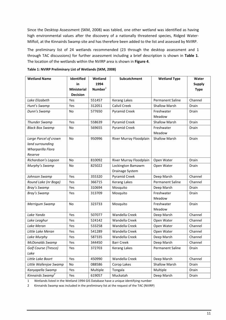
Since the Desktop Assessment (SKM, 2008) was tabled, one other wetland was identified as having high environmental values after the discovery of a nationally threatened species, Ridged Water‐Milfoil, at the Kinnairds Swamp site and has therefore been added to the list and assessed by NVIRP.
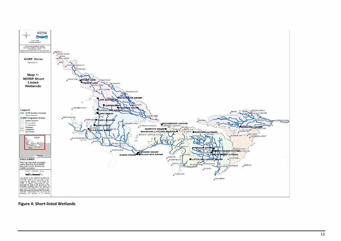
The preliminary list of 24 wetlands recommended (23 through the desktop assessment and 1 through TAC discussions) for further assessment including a brief description is shown in Table 1. The location of the wetlands within the NVIRP area is shown in Figure 4.
Table 1: NVIRP Preliminary List of Wetlands (SKM, 2008)
Wetland Name Identified in
Ministerial Decision
Wetland 1994
Number1
Subcatchment Wetland Type Water Supply Type
Lake Elizabeth Yes 551457 Kerang Lakes Permanent Saline Channel
Hunt’s Swamp Yes 312051 Calivil Creek Shallow Marsh Drain
Dunn’s Swamp No 577650 Pyramid Creek Freshwater Meadow
Drain
Thunder Swamp Yes 558639 Pyramid Creek Shallow Marsh Drain
Black Box Swamp No 569655 Pyramid Creek Freshwater Meadow
Drain
Large Parcel of crown land surrounding Wharparilla Flora Reserve
No 950996 River Murray Floodplain Shallow Marsh Drain
Richardson’s Lagoon No 810092 River Murray Floodplain Open Water Drain
Murphy’s Swamp No 825022 Lockington Bamawm Drainage System
Open Water Drain
Johnson Swamp Yes 355320 Pyramid Creek Deep Marsh Channel
Round Lake (nr Boga) Yes 366715 Kerang Lakes Permanent Saline Channel
Bray’s Swamp Yes 310694 Mosquito Deep Marsh Drain
Bray’s Swamp Yes 313709 Mosquito Freshwater Meadow
Drain
Merrigum Swamp No 323733 Mosquito Freshwater Meadow
Drain
Lake Yando Yes 507077 Wandella Creek Deep Marsh Channel
Lake Leaghur Yes 524142 Wandella Creek Open Water Channel
Lake Meran Yes 533258 Wandella Creek Open Water Channel
Little Lake Meran Yes 541289 Wandella Creek Open Water Channel
Lake Murphy Yes 587335 Wandella Creek Deep Marsh Channel
McDonalds Swamp Yes 344450 Barr Creek Deep Marsh Channel
Golf Course (Tresco) Lake
Yes 372703 Kerang Lakes Permanent Saline Drain
Little Lake Boort Yes 450990 Wandella Creek Deep Marsh Channel
Little Wallenjoe Swamp No 088586 Corop Lakes Shallow Marsh Drain
Kanyapella Swamp Yes Multiple Tongala Multiple Drain
Kinnairds Swamp2 Yes 619057 Muckatah Deep Marsh Drain1 Wetlands listed in the Wetland 1994 GIS Database have a unique identifying number 2 Kinnairds Swamp was included in the preliminary list at the request of the TAC (NVIRP)

12
To review and refine the preliminary list of wetlands in Table 1 that will require EWP development or revision, NVIRP has undertaken a Wetland Short‐listing Report to confirm whether or not NVIRP works will impact on water supply of the 24 listed Wetlands.
This short‐listing process will assist NVIRP to satisfy the requirements of Condition 5 of the Minister for Planning’s Decision under the Environment Effects Act.
13
Figure 4: Short‐listed Wetlands
14
4.2 Wetland Validation and Short‐listing
The preliminary list of wetlands identified in the desktop assessment requires validation. However, some of the wetlands are on the preliminary list because of insufficient data available. In these cases, further investigation will be conducted to confirm the site’s connection to the irrigation distribution system.
The process for validation will:
• confirm source of water supply to wetland through:
o site inspections o data collection, where relevant
• determine if existing water supply is sourced from incidental irrigation water.
• determine wetlands for which EWPs are recommended
• recommend timing for EWP preparation in relation to NVIRP’s program of works.
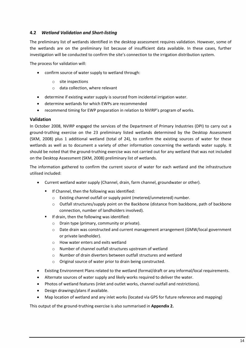
Validation In October 2008, NVIRP engaged the services of the Department of Primary Industries (DPI) to carry out a ground‐truthing exercise on the 23 preliminary listed wetlands determined by the Desktop Assessment (SKM, 2008) plus 1 additional wetland (total of 24), to confirm the existing sources of water for these wetlands as well as to document a variety of other information concerning the wetlands water supply. It should be noted that the ground‐truthing exercise was not carried out for any wetland that was not included on the Desktop Assessment (SKM, 2008) preliminary list of wetlands.
The information gathered to confirm the current source of water for each wetland and the infrastructure utilised included:
• Current wetland water supply (Channel, drain, farm channel, groundwater or other).
If Channel, then the following was identified: o Existing channel outfall or supply point (metered/unmetered) number. o Outfall structures/supply point on the Backbone (distance from backbone, path of backbone
connection, number of landholders involved). If drain, then the following was identified:
o Drain type (primary, community or private). o Date drain was constructed and current management arrangement (GMW/local government
or private landholder). o How water enters and exits wetland o Number of channel outfall structures upstream of wetland o Number of drain diverters between outfall structures and wetland o Original source of water prior to drain being constructed.
• Existing Environment Plans related to the wetland (formal/draft or any informal/local requirements.
• Alternate sources of water supply and likely works required to deliver the water.
• Photos of wetland features (inlet and outlet works, channel outfall and restrictions).
• Design drawings/plans if available.
• Map location of wetland and any inlet works (located via GPS for future reference and mapping)
This output of the ground‐truthing exercise is also summarised in Appendix 2.
15
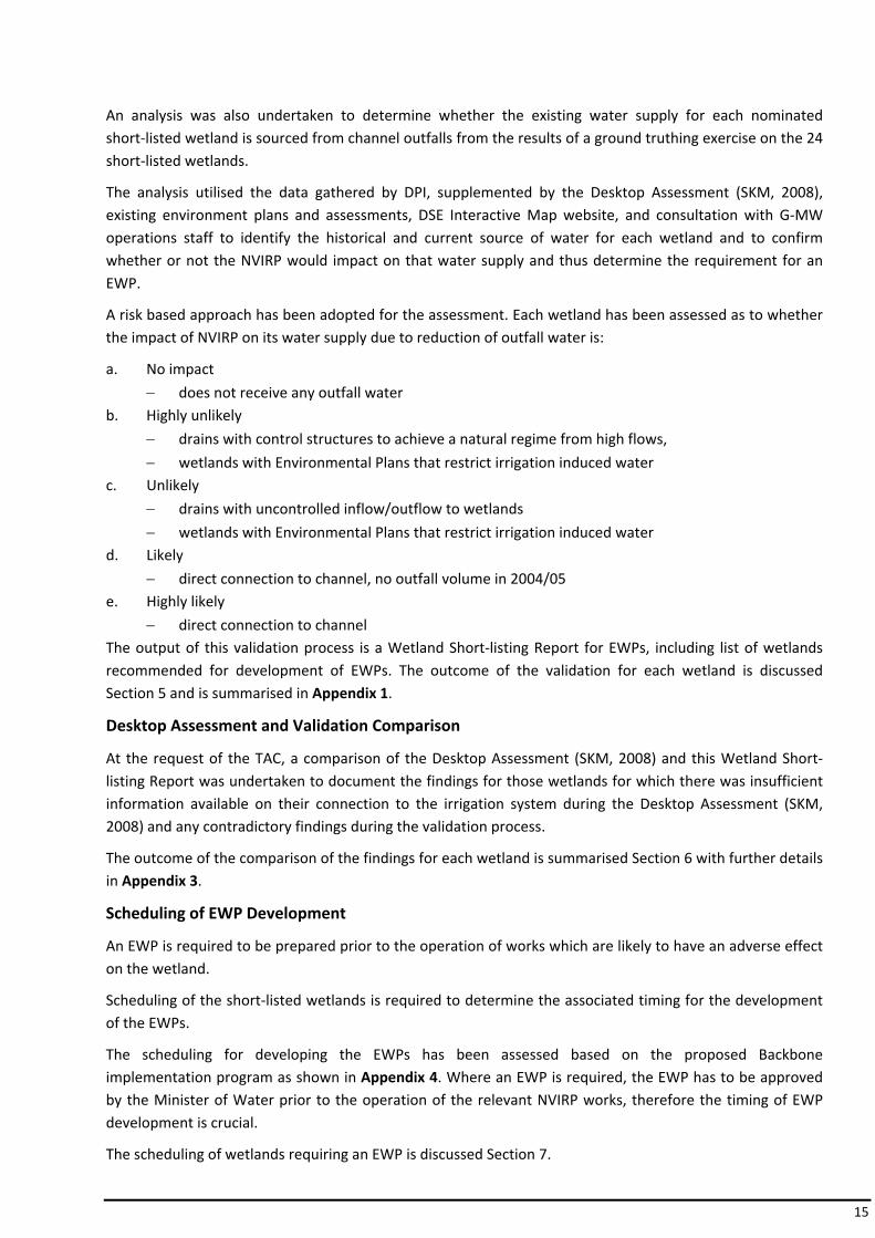
An analysis was also undertaken to determine whether the existing water supply for each nominated short‐listed wetland is sourced from channel outfalls from the results of a ground truthing exercise on the 24 short‐listed wetlands.
The analysis utilised the data gathered by DPI, supplemented by the Desktop Assessment (SKM, 2008), existing environment plans and assessments, DSE Interactive Map website, and consultation with G‐MW operations staff to identify the historical and current source of water for each wetland and to confirm whether or not the NVIRP would impact on that water supply and thus determine the requirement for an EWP.
A risk based approach has been adopted for the assessment. Each wetland has been assessed as to whether the impact of NVIRP on its water supply due to reduction of outfall water is:
a. No impact
− does not receive any outfall water b. Highly unlikely
− drains with control structures to achieve a natural regime from high flows,
− wetlands with Environmental Plans that restrict irrigation induced water c. Unlikely
− drains with uncontrolled inflow/outflow to wetlands
− wetlands with Environmental Plans that restrict irrigation induced water d. Likely
− direct connection to channel, no outfall volume in 2004/05 e. Highly likely
− direct connection to channel The output of this validation process is a Wetland Short‐listing Report for EWPs, including list of wetlands recommended for development of EWPs. The outcome of the validation for each wetland is discussed Section 5 and is summarised in Appendix 1.
Desktop Assessment and Validation Comparison
At the request of the TAC, a comparison of the Desktop Assessment (SKM, 2008) and this Wetland Short‐listing Report was undertaken to document the findings for those wetlands for which there was insufficient information available on their connection to the irrigation system during the Desktop Assessment (SKM, 2008) and any contradictory findings during the validation process.
The outcome of the comparison of the findings for each wetland is summarised Section 6 with further details in Appendix 3.
Scheduling of EWP Development
An EWP is required to be prepared prior to the operation of works which are likely to have an adverse effect on the wetland.
Scheduling of the short‐listed wetlands is required to determine the associated timing for the development of the EWPs.
The scheduling for developing the EWPs has been assessed based on the proposed Backbone implementation program as shown in Appendix 4. Where an EWP is required, the EWP has to be approved by the Minister of Water prior to the operation of the relevant NVIRP works, therefore the timing of EWP development is crucial.
The scheduling of wetlands requiring an EWP is discussed Section 7.
16
4.3 Environmental Watering Plans
Where a wetland with high environmental values could be adversely affected due to the changed irrigation water contribution by the implementation of NVIRP, an EWP will be prepared. The EWP will set out the ongoing management and mitigation of the effects due to the implementation of NVIRP.
Where it is determined that the removal of incidental irrigation water from a wetland is beneficial or will not have a significant impact, then NVIRP is not required to prepare an EWP.
The findings from the risk based assessment carried out for this Report determined the requirements for the development of EWPs. For each impact from NVIRP on water supply to wetlands due to reduction of outfall water identified, the following applies for the development of EWPs:
a. No impact
− Development of EWP not required b. Highly unlikely
− Development of EWP not required c. Unlikely
− Development of EWP not required d. Likely
− Development of EWP required e. Highly likely
− Development of EWP required
17
5 Outcomes of Wetlands Validation
5.1 Lake Elizabeth
5.1.1 Site Description
Lake Elizabeth has a surface area of 94 ha and has high environmental values. It is located on crown land within the subcatchment of Kerang Lakes in the Torrumbarry Irrigation Area and North Central Catchment region. This lake is a Wildlife Reserve and is managed by Parks Victoria.
The original source/supply of water to Lake Elizabeth is not confirmed, but it is suspected to be breakaways from Wandella Creek to the east or overflow from the Kerang Lake system via its inlet channel from Duck Lake to the north.
5.1.2 Existing Management Plans
• Phillip Macumber (2007). Lake Elizabeth operational Plans and Management Options – the Implications for Lake Level and Salinity.
• DCNR (1996) Wetland Management Strategy – Lake Elizabeth, Kerang.
5.1.3 Current Water Supply
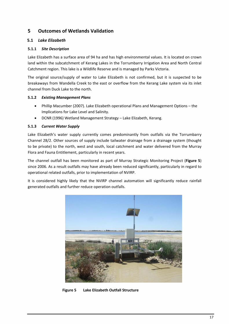
Lake Elizabeth’s water supply currently comes predominantly from outfalls via the Torrumbarry Channel 28/2. Other sources of supply include tailwater drainage from a drainage system (thought to be private) to the north, west and south, local catchment and water delivered from the Murray Flora and Fauna Entitlement, particularly in recent years.
The channel outfall has been monitored as part of Murray Strategic Monitoring Project (Figure 5) since 2006. As a result outfalls may have already been reduced significantly, particularly in regard to operational related outfalls, prior to implementation of NVIRP.
It is considered highly likely that the NVIRP channel automation will significantly reduce rainfall generated outfalls and further reduce operation outfalls.
Figure 5 Lake Elizabeth Outfall Structure
18
5.1.4 Conclusion
The water supply of Lake Elizabeth is highly likely to be impacted on by the NVIRP and therefore the development of an Environmental Watering Plan will be required.
5.2 Hunt’s Swamp
5.2.1 Site Description
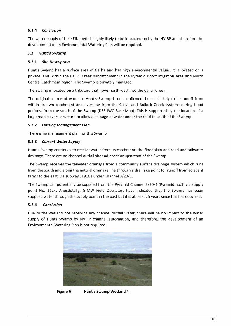
Hunt’s Swamp has a surface area of 61 ha and has high environmental values. It is located on a private land within the Calivil Creek subcatchment in the Pyramid Boort Irrigation Area and North Central Catchment region. The Swamp is privately managed.
The Swamp is located on a tributary that flows north west into the Calivil Creek.
The original source of water to Hunt’s Swamp is not confirmed, but it is likely to be runoff from within its own catchment and overflow from the Calivil and Bullock Creek systems during flood periods, from the south of the Swamp (DSE IWC Base Map). This is supported by the location of a large road culvert structure to allow a passage of water under the road to south of the Swamp.
5.2.2 Existing Management Plan
There is no management plan for this Swamp.
5.2.3 Current Water Supply
Hunt’s Swamp continues to receive water from its catchment, the floodplain and road and tailwater drainage. There are no channel outfall sites adjacent or upstream of the Swamp.
The Swamp receives the tailwater drainage from a community surface drainage system which runs from the south and along the natural drainage line through a drainage point for runoff from adjacent farms to the east, via subway ST9161 under Channel 3/20/1.
The Swamp can potentially be supplied from the Pyramid Channel 3/20/1 (Pyramid no.1) via supply point No. 1124. Anecdotally, G‐MW Field Operators have indicated that the Swamp has been supplied water through the supply point in the past but it is at least 25 years since this has occurred.
5.2.4 Conclusion
Due to the wetland not receiving any channel outfall water, there will be no impact to the water supply of Hunts Swamp by NVIRP channel automation, and therefore, the development of an Environmental Watering Plan is not required.
Figure 6 Hunt’s Swamp Wetland 4
19
5.3 Dunn’s Swamp
5.3.1 Site Description
Dunn’s Swamp has a surface area of 35 ha and is located on private land within the Pyramid Creek (Myers Creek and Bendigo Creek) subcatchment in the Pyramid Boort Irrigation Area and the North Central Catchment region. The environmental value of the area is unknown. The Swamp is privately managed.
Dunn’s Swamp is part of a depression system of the Myers Creek Depression and historically has received its water supply from an active floodplain.
5.3.2 Existing Management Plan
There is currently no management plan for this Swamp.
5.3.3 Current Water Supply
The Swamp is now partly isolated from the depression system by land forming and cultivation.
Dunn’s Swamp does not receive any water from channel outfall. The Swamp’s current water supply is predominately from runoff collected by a network of road culverts to the south east corner and the active floodplain. There is also a private drainage system through the Swamp installed in the 1980's to alleviate wider flooding of surrounding paddocks which drains to the north west of the Swamp through Black Box Swamp to Myers Creek. There are no channel outfall sites adjacent to or upstream of the Swamp.
The Swamp does not currently have any channel delivery connection; however the Waranga Western Main is located approximately 1800m to the east of the Swamp.
5.3.4 Conclusion
The Desktop Assessment (SKM, 2008) was unable to assess the likely water regime changes to Dunn’s Swamp due to insufficient information available and was therefore included in the 24 short‐listed wetlands.
Further information was gained during the assessment carried out for this Report, indicating that there will be no impact to the water supply of Dunns Swamp by NVIRP channel automation as the Swamp is not connected to a channel system, and therefore, the development of an Environmental Watering Plan is not required.
5.4 Thunder Swamp
5.4.1 Site Description
Thunder Swamp has a surface area of 60 ha and has high environmental values. It is located on a Crown Reserve within the Pyramid Creek (Myers Creek and Bendigo Creek) subcatchment in the Pyramid Boort Irrigation Area and the North Central Catchment region. This Swamp is a Wildlife Reserve, managed by Parks Victoria.
Thunder Swamp is part of a depression system of the Myers Creek Depression. The Swamp is a shallow basin located adjacent to Myers Creek with a natural inlet and outlet. The Swamp is manipulated and isolated by land forming and cultivation. The original source/supply of water to Thunder Swamp is not confirmed, but is suspected that the Swamp would have received natural flows in flood events from Myers Creek.

20
5.4.2 Management Plan
There is currently no management plan for this Swamp.
5.4.3 Current Water Supply
The current water supply of Thunder Swamp is from the active floodplain of Myers Creek. Myers Creek flows through the “Thunder Syphon” (ST 29691) on the Waranga Western Channel located to the south east of the Swamp. There is also a subway under the channel to the south of the Swamp and west of “Thunder Syphon”. There are no channel outfall sites adjacent to or upstream of the Swamp.
There is currently no channel delivery connection to the Swamp, the closest being the Waranga Western Channel which is located 270 metres to the south of the Swamp.
5.4.4 Conclusion
The Desktop Assessment (SKM, 2008) was unable to assess the likely water regime changes to Thunder Swamp due to insufficient information available and was therefore included in the 24 short‐listed wetlands.
Further information was gained during the assessment carried out for this Report, indicating that the wetland is not connected to the channel system and does not receive any channel outfall water. As a result there will be no impact to the water supply of Thunder Swamp by NVIRP channel automation, and therefore the development of an Environmental Watering Plan is not required.
5.5 Black Box Swamp
5.5.1 Site Description
Black Box Swamp has a surface area of 66 ha and is located on private land within the Pyramid Creek (Myers Creek and Bendigo Creek) subcatchment in the Pyramid Boort Irrigation Area and the North Central Catchment region. The environmental value of the Swamp is unknown. The Swamp is privately managed.
Dunn’s Swamp is part of a depression system of the Myers Creek Depression and historically has received its water supply from the active floodplain through Dunn’s Swamp.
5.5.2 Management Plan
There is currently no management plan for this Swamp.
5.5.3 Current Water Supply
The Swamp is now partly isolated from the depression system by land forming and cultivation.
There are no channel outfall sites adjacent to or upstream of the Swamp.
The Swamp currently receives its water supply from runoff collected by a network of new road culverts to the south east and from spill and fill events from Dunns Swamp and Myers Creek that feed from the active floodplain.
A private community drainage system was constructed in the 1980’s to allow water to drain from the Swamp more effectively to alleviate wider flooding of surrounding paddocks. The drain flows to the north west of the Swamp to Myers Creek.

21
The Swamp does not currently have any channel delivery connection; however the Waranga Western Channel is located approximately 1800m to the east of the Swamp.
Figure 7 Black Box Swamp
5.5.4 Conclusion
The Desktop Assessment (SKM, 2008) was unable to assess the likely water regime changes to Black Box Swamp due to insufficient information available and was therefore included in the 24 short‐listed wetlands.
Further information was gained during the assessment carried out for this Report, indicating that NVIRP channel automation will have no impact on the water supply of Black Box Swamp due to the wetland not being connected to the channel system or receiving any channel outfall water. The development of an Environmental Watering Plan is not required.
5.6 Wharparilla Flora Reserve
5.6.1 Site Description
The Wharparilla Flora Reserve Wetland (Wharparilla Wetland) has a surface area of 19 ha and is located on crown land within the Rochester Irrigation Area and the North Central Catchment region. The environmental values of the Wetland are unknown. This wetland is a Flora Reserve and is managed by DSE, Parks and Forest.
The original water supply to the Wharparilla Wetland is via the upstream section of the streams located south of the Wetland and also from flooding of the Campaspe River.
5.6.2 Management Plan
There is currently no management plan for this wetland.
5.6.3 Current Water Supply
Wharparilla Wetland currently receives its water supply from the Rochester Drain No. 1 through an inlet structure at Murray Valley Highway. Drainage from a housing development to the south of the Wetland may also contribute.
A drain has been constructed around the side of the wetland to keep minor flows including irrigation generated flow out of Wharparilla Wetland. Higher flows in the drain will overflow the banks, into the wetland due to the structure under the road on the east side of the Wetland.
Channel outfalls from Rochester Channel 5/3/14 do enter the Rochester Drain No. 1, however due to the works described above and works being completed with a G‐MW customer on the end of Channel 5/3/14 to utilise outfall water from the channel, the amount of outfalls to Wharparilla Wetland has been reduced to a negligible amount over the past 5 years.
22
5.6.4 Conclusion
The Desktop Assessment (SKM, 2008) was unable to assess the likely water regime changes to Wharparilla Wetland due to insufficient information available and was therefore included in the 24 short‐listed wetlands.
Further information was gained during the assessment carried out for this Report, indicating that the probability of NVIRP channel automation having an impact on the water supply of Wharparilla Wetland is highly unlikely as the Wetland only receives water from high flow events on the drain and does not receive outfall water. The development of an Environmental Watering Plan is not required.
5.7 Richardson’s Lagoon
5.7.1 Site Description
Richardson’s Lagoon has a surface area of 120 ha and is located on crown land on a River Murray Floodplain within the Rochester Irrigation Area and the North Central Catchment region. The Lagoon is an old cut‐off loop of the River Murray and is a Wildlife reserve managed by Parks Victoria. Richardson’s Lagoon is a deep freshwater marsh and is a particularly important waterbird breeding, feeding and roosting site and is part of an extremely productive wetland system.
The original supply of water to Richardson’s lagoon was the flooding of the River Murray, which has been reduced by the regulation of the River.
When the Lockington and Bamawm drains were constructed in the late 1960’s to early 1970’s, an outlet structure on the drain was installed to divert water into the Lagoon.
In 1992, a fixed crest weir, inlet/outlet structures and bypass drain was installed to allow better management of the water entering the Lagoon.
5.7.2 Management Plan
• SKM (1999) Richardson’s Lagoon and Murphy’s Swamp Environmental Management Plan.
5.7.3 Current Water Supply
Implementation of aspects of the Richardson’s Lagoon and Murphy’s Swamp Environmental Management Plan has seen the completion of works to stop any irrigation induced flows from drains entering Richardson’s Lagoon to alleviate water quality issues and establish a more appropriate water regime. A large pump and pontoon on the River Murray is now used to provide good quality environmental water to the Lagoon. Water from the Murray Flora and Fauna Entitlement is supplied to the Lagoon.
5.7.4 Conclusion
The Desktop Assessment (SKM, 2008) was unable to assess the likely water regime changes to Richardson’s Lagoon due to insufficient information available and was therefore included in the 24 short‐listed wetlands.
Further information was gained during the assessment carried out for this Report, indicating that it is highly unlikely that NVIRP channel automation will impact on the water supply of Richardson’s Lagoon as the implementation of the Richardson’s Lagoon and Murphy’s Swamp Environmental Management Plan and other subsequent environmental investigations has resulted in channel
23
outfalls being prevented from entering the Lagoon. Therefore, the development of an Environmental Watering Plan is not required.
5.8 Murphy’s Swamp
5.8.1 Site Description
Murphy’s Swamp has a surface area of 88.4 ha and is located on crown land within the Bamawm Drainage system subcatchment in the Rochester Irrigation Area and the North Central Catchment region. The Swamp is a Wildlife Reserve and also a Water Boards Reserve, and is managed by Parks Victoria and Goulburn‐Murray Water.
Historically, the water supply to Murphy’s Swamp was runoff from the Bamawm Depression to the south of the wetland.
5.8.2 Management Plan
• SKM (1999) Richardson’s Lagoon and Murphy’s Swamp Environmental Management Plan.
5.8.3 Current Water Supply
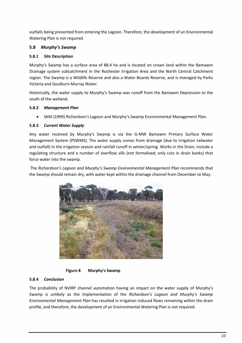
Any water received by Murphy’s Swamp is via the G‐MW Bamawm Primary Surface Water Management System (PSWMS). The water supply comes from drainage (due to irrigation tailwater and outfall) in the irrigation season and rainfall runoff in winter/spring. Works in the Drain, include a regulating structure and a number of overflow sills (not formalised; only cuts in drain banks) that force water into the swamp.
The Richardson’s Lagoon and Murphy’s Swamp Environmental Management Plan recommends that the Swamp should remain dry, with water kept within the drainage channel from December to May.
Figure 8 Murphy’s Swamp
5.8.4 Conclusion
The probability of NVIRP channel automation having an impact on the water supply of Murphy’s Swamp is unlikely as the implementation of the Richardson’s Lagoon and Murphy’s Swamp Environmental Management Plan has resulted in irrigation induced flows remaining within the drain profile, and therefore, the development of an Environmental Watering Plan is not required.
24
5.9 Johnson Swamp
5.9.1 Site Description
Johnson Swamp has a surface area of 411 ha and is located on crown land within the Pyramid Creek subcatchment in the Torrumbarry Irrigation Area and the North Central Catchment region. It is managed by Parks Victoria. The Swamp is a Wildlife Reserve, is listed under the Ramsar Convention and has very high environmental values.
The original source of water supplied to Johnson Swamp was from the Pyramid Creek. It is believed that originally Pyramid Creek flowed through the Swamp, intermittently flooding the Swamp. With the advent of irrigation in the 1920’s, the swamp became permanently inundated. The dredging of Pyramid Creek in 1967 resulted in Johnson Swamp being divided into two (the larger section (western) is commonly the section that is referred to as Johnson Swamp) and removed from its natural water supply, resulting in flood flows to now only enter the Swamp in major floods. Currently, the Swamp can only be naturally inundated during major flood events.
5.9.2 Management Plan
• SKM (2001) Johnson Swamp (west side) Watering and Operational Plan.
5.9.3 Current Water Supply
Water received by Johnson Swamp is predominantly supplied through the outfall structure on the Torrumbarry Channel 4/7/2 and from local runoff including some tailwater drainage.
In 1987, Johnson Swamp was provided with a dedicated environmental water allocation of 2600 ML/yr shared with Hird Swamp, located further upstream on the Pyramid Creek. This specific volume was not directly defined within the Murray Bulk Water Entitlement conversion.
It is understood that water passing through the outfall structure is predominantly from the Murray Flora and Fauna Entitlement and partly from rainfall induced outfall. Operational outfalls bypass Johnson Swamp directly into Pyramid Creek which allows the water to be delivered or stored for productive use, further downstream.
It is considered that the NVIRP channel automation may have some impact on rainfall generated outfalls.
5.9.4 Conclusion
The water supply of Johnson Swamp is highly likely to be impacted by the NVIRP channel automation and therefore will require the development of an Environmental Watering Plan.
5.10 Round Lake (near Lake Boga)
5.10.1 Site Description
Round Lake has an area of 42 ha and is located on crown land within the Kerang Lakes subcatchment in the Torrumbarry Irrigation Area and the North Central Catchment region. The Lake is a Water Supply Reserve, managed by G‐MW. It is particularly significant because it contains the Murray Hardyhead (Craterocephalus fluviatilis) fish which is listed as Vulnerable under the EPBC Act.
Round Lake is the second in a series of three connected drainage basins, under natural conditions it would have received overflow from Golf Course (Tresco) Lake, then in turn would have overflowed into Long Lake to the north.
25
5.10.2 Management Plan
There is currently no management plan for Round Lake, however a feasibility study into the flushing of Golf Course, Round and Long Lakes has been undertaken. Detailed vegetation mapping has also been carried out for the Lake.
5.10.3 Current Water Supply
Round Lake receives environmental water through the outfall structure on the end of the Torrumbarry Channel 1/9.
Since 2002/03, the predominant water source has been water from the Murray Flora and Fauna Entitlement provided to protect environmental values.
5.10.4 Conclusion
It is highly likely that the water supply of Round Lake will be impacted by the NVIRP channel automation; therefore an Environmental Watering Plan will be required for Round Lake.
5.11 Bray’s Swamp (310694)
Bray’s Swamp (310694) has a surface area of 24 ha and has high environmental values. The Swamp is on private land within the Mosquito subcatchment in the Central Goulburn Irrigation Area and Goulburn Broken Catchment region. Bray’s Swamp is privately managed.
The original water source to Bray’s Swamps was runoff from the Byrneside Mosquito Depression.
5.11.1 Management Plan
• DPI (2001) Bray’s Swamp Wetland Management Plan.
• Surface Water Management Schemes: Mosquito 24 Primary Scheme – has been designed to provide effective drainage from the catchment over a 5 day period in the event of a 1 in 2 year rainfall event.
5.11.2 Current Water Supply
Bray’s Swamp currently receives its water supply from Mosquito 24 PSWMS Drain constructed in 1996. There are a series of rock sills in the drain that operate only during high flow events (> 75ML/d). Therefore any contributions to flow from upstream outfalls are likely to have bypassed the Swamp.
Originally, water was forced over the sills by the provision of a choke downstream of each sill, however, due to the dry conditions since the drain implementation, it is understood that the chokes have been replaced with gate structures to ensure delivery of the design event water regimes.
There is no outfall water component to the drain flows as there are no channel outfall sites on the Mosquito 24 drain upstream of Brays Swamp.
It is understood the works have been undertaken by G‐MW to a landholder’s internal supply system to allow environmental water to be supplied from the CG No. 8 Channel. Volumes from the Murray Flora and Fauna Entitlement (Murray system) and also from the Stockyard Plain entitlement (Goulburn system) have been delivered to the Swamp through these works in 2004/05 and 2005/06.
26
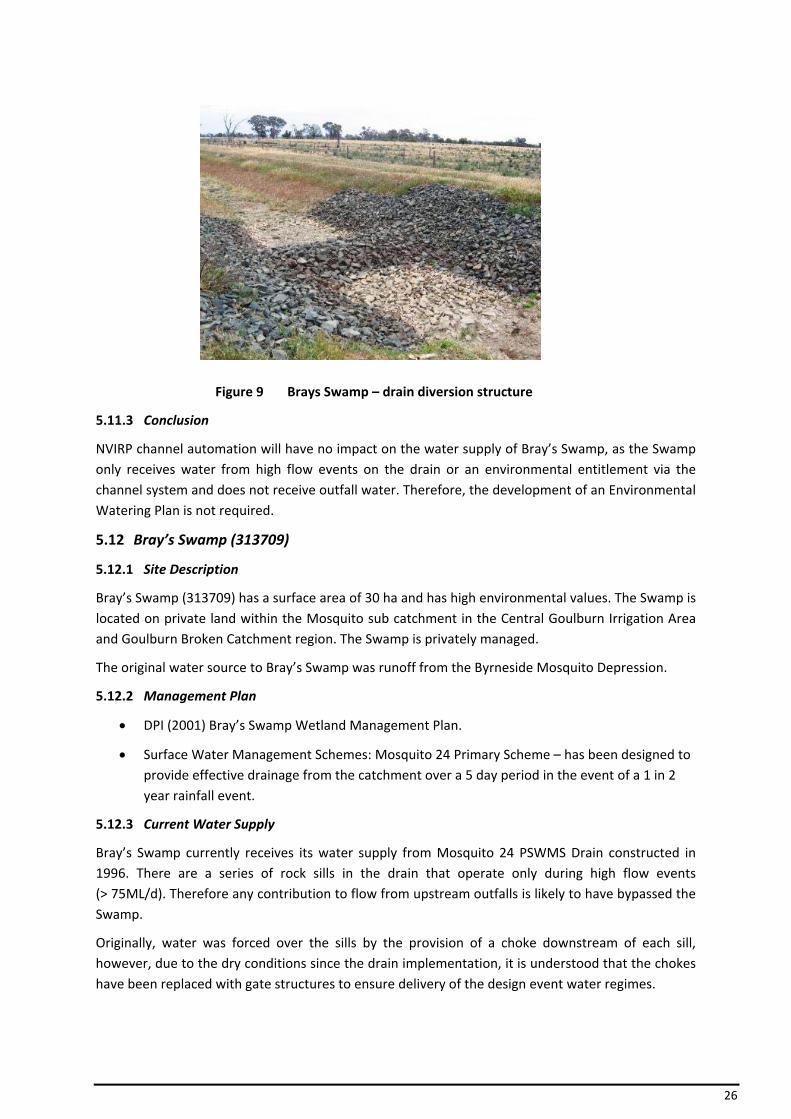
Figure 9 Brays Swamp – drain diversion structure
5.11.3 Conclusion
NVIRP channel automation will have no impact on the water supply of Bray’s Swamp, as the Swamp only receives water from high flow events on the drain or an environmental entitlement via the channel system and does not receive outfall water. Therefore, the development of an Environmental Watering Plan is not required.
5.12 Bray’s Swamp (313709)
5.12.1 Site Description
Bray’s Swamp (313709) has a surface area of 30 ha and has high environmental values. The Swamp is located on private land within the Mosquito sub catchment in the Central Goulburn Irrigation Area and Goulburn Broken Catchment region. The Swamp is privately managed.
The original water source to Bray’s Swamp was runoff from the Byrneside Mosquito Depression.
5.12.2 Management Plan
• DPI (2001) Bray’s Swamp Wetland Management Plan.
• Surface Water Management Schemes: Mosquito 24 Primary Scheme – has been designed to provide effective drainage from the catchment over a 5 day period in the event of a 1 in 2 year rainfall event.
5.12.3 Current Water Supply
Bray’s Swamp currently receives its water supply from Mosquito 24 PSWMS Drain constructed in 1996. There are a series of rock sills in the drain that operate only during high flow events (> 75ML/d). Therefore any contribution to flow from upstream outfalls is likely to have bypassed the Swamp.
Originally, water was forced over the sills by the provision of a choke downstream of each sill, however, due to the dry conditions since the drain implementation, it is understood that the chokes have been replaced with gate structures to ensure delivery of the design event water regimes.
27
There is no outfall water component to the drain flows as there are no channel outfall sites on the Mosquito 24 drain upstream of Brays Swamp.
It is understood the works undertaken by G‐MW to a landholder internal supply system to allow environmental water to be supplied from the CG No. 8 Channel. Volumes from the Murray Flora and Fauna Entitlement (Murray system) and also from the Stockyard Plain entitlement (Goulburn system) have been delivered to the Swamp through these works in 2004/05 and 2005/06.
5.12.4 Conclusion
NVIRP channel automation will have no impact on the water supply of Bray’s Swamp, as the Swamp only receives water from high flow events on the drain or an environmental entitlement via the channel system and does not receive outfall water. Therefore, the development of an Environmental Watering Plan is not required.
5.13 Merrigum Swamp
5.13.1 Site Description
Merrigum Swamp has an area of 34 ha and is located on private land within the Mosquito subcatchment in the Central Goulburn Irrigation Area and the Goulburn Broken Catchment region and is privately managed. The Swamp has high environmental values.
The original water supply for the Merrigum Swamp was natural runoff through the Mosquito Depression.
5.13.2 Management Plan
There is no management plan for this Swamp.
5.13.3 Current Water Supply
The current water supply to Merrigum Swamp comes from the Mosquito Main PSWMS Depression Drain. High flow events are allowed to flow into the Swamp via a sill and floodway culvert. There is no outfall water component to the drain flows as there are no channel outfall sites on the Mosquito Main Drain upstream of the Swamp.
5.13.4 Conclusion
The Desktop Assessment (SKM, 2008) was unable to assess the likely water regime changes to Merrigum Swamp due to insufficient information available and was therefore included in the 24 short‐listed wetlands.
Further information was gained during the assessment carried out for this Report, indicating that NVIRP channel automation will have no impact on the water supply to Merrigum Swamp, as the Swamp only receives water from high flow events on the drain and does not receive outfall water. Therefore, the development of an Environmental Watering Plan is not required.
28
5.14 Lake Yando
5.14.1 Site Description
Lake Yando has an area of 83 ha and is located on crown land within the Wandella Creek subcatchment in the Pyramid Boort Irrigation Area and the North Central Catchment region. The Lake is a Wildlife Reserve managed by Parks Victoria and has high environmental values.
Lake Yando’s original source of water came from the natural inflows from the Venables Creek System and Loddon River.
5.14.2 Management Plan
There is currently no management plan for Lake Yando, however there is:
• ECOS (2007) Boort District Wetlands Vegetation Assessment.
5.14.3 Current Water Supply
Lake Yando’s water supply currently comes from channel outfalls via the Pyramid Channel 5/2, local drainage and Loddon River floodwater.
The current channel outfall only has a capacity of 6Ml/d. Works are currently being undertaken to increase the outfall channel and structure’s capacity to allow delivery of environmental water.
5.14.4 Conclusion
The water regime of Lake Yando is highly likely to be impacted by the NVIRP due to its reliance on channel outfall, therefore an Environmental Watering Plan will be required for the Lake.
5.15 Lake Leaghur
5.15.1 Site Description
Lake Leaghur has an area of 63 ha and is located on crown land within the Wandella Creek subcatchment in the Pyramid Boort Irrigation Area and the North Central Catchment region. The Lake is a Water Reserve managed by G‐MW and has high environmental values.
The original source of water for Lake Leaghur is from natural inflows from Loddon River and both the Venables and Wandella Creek systems.
5.15.2 Management Plan
There is currently no management plan for this Lake, however there is:
• ECOS (2007) Boort District Wetlands Vegetation Assessment; and
• SKM (2001) Lake Leaghur Environmental Assessment.
5.15.3 Current Water Supply
Lake Leaghur’s water supply currently comes from channel outfalls via the Pyramid Channel 2/2 (ST 25235), which is a fully automated outfall structure. Venables and Wandella Creek continue to feed the Lake when they are flowing, along with the Loddon River when it floods.
The channel outfall has been monitored as part of the Murray Strategic Monitoring Project since 2007. As a result outfalls may have already reduced significantly, particularly in regard to operational related outfalls.
29
It is considered that the NVIRP channel automation is likely to significantly reduce rainfall generated outfalls, further reduce operation outfalls and maintain minimal channel outfall into the future.
5.15.4 Conclusion
It is highly likely that the water supply to Lake Leaghur will be impacted by the NVIRP due to its reliance on channel outfall water, therefore an Environmental Watering Plan will be required for the Lake.
5.16 Lake Meran
5.16.1 Site Description
Lake Meran has an area of 175 ha and is located on crown land within the Wandella Creek subcatchment in the Pyramid Boort Irrigation Area and the North Central Catchment region. The Lake is a Lake Reserve managed by a Committee of Management and has high environmental values.
The original water supply to Lake Meran came from Wandella Creek in the Loddon System and flood waters that transversed the Leaghur State Forest. Pickles Canal carries floodwater from Wandella Creek and the Leaghur State Forest to the Lake’s natural inlet.
5.16.2 Management Plan
There is currently no management plan for this Lake, however there is:
• ECOS (2006) Meran Lakes Complex Environmental Values Assessment; and
• GHD (2006) DRAFT Meran Lakes Complex Water Operational Plan – Surface Water Management Investigation.
5.16.3 Current Water Supply
Lake Meran’s water supply currently comes from fully automated channel outfall on Boort Channel 8/2 (ST 23656) via the delivery channel also called Pickles Canal. The Lake is still connected to the active floodplain.
The channel outfall has been monitored as part of the Murray Strategic Monitoring Project. As a result outfalls may have already reduced significantly, particularly in regard to operational related outfalls, prior to the implementation of the NVIRP.
It is considered likely that NVIRP channel automation will significantly reduce rainfall generated outfalls, further reduce operational outfalls and maintain minimal channel outfalls into the future.
5.16.4 Conclusion
The water supply to Lake Meran is highly likely to be impacted by the NVIRP due to its reliance on channel outfall water; therefore an Environmental Watering Plan will be required for the Lake.
5.17 Little Lake Meran
5.17.1 Site Description
Little Lake Meran has an area of 27 ha and is located on crown land within the Wandella Creek subcatchment in the Pyramid Boort Irrigation Area and the North Central Catchment region. The Lake is a Wildlife Reserve managed by Parks Victoria and has high environmental values.
30
The original water supply to Little Lake Meran was floodwater from Lake Meran and Wandella Creek in the Loddon System. The construction of a levee system in 1934 has isolated the wetland from the floodplain.
5.17.2 Management Plan
• ECOS (2006) Meran Lakes Complex Environmental Values Assessment; and
• GHD (2006) DRAFT Meran Lakes Complex Water Operational Plan – Surface Water Management Investigation.
5.17.3 Current Water Supply
Little Lake Meran’s only water supply currently comes from channel outfall on Boort Channel 4/8/2.
The recent reduction in channel outfalls as a result of drought and increased operational efficiency of the irrigation system has significantly reduced channel outfalls to this Lake.
5.17.4 Conclusion
It is highly likely that the water supply of Little Lake Meran will be impacted by the NVIRP due to its reliance on channel outfall water, therefore an Environmental Watering Plan will be required for the Lake.
5.18 Lake Murphy
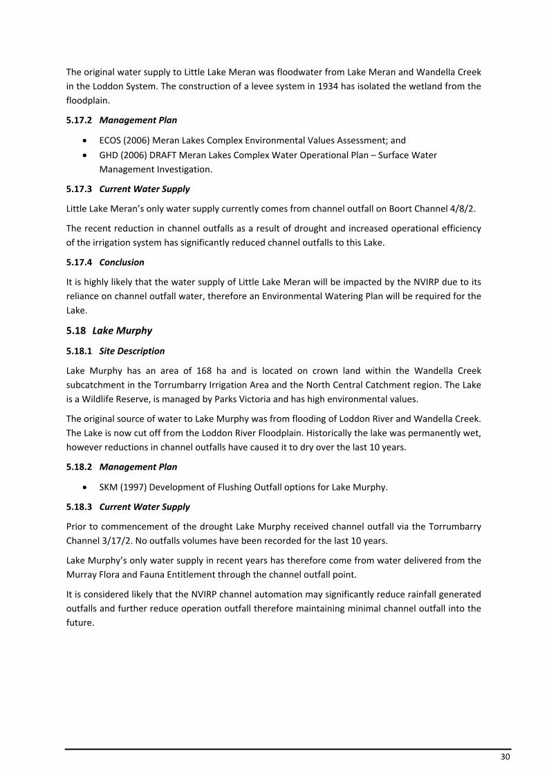
5.18.1 Site Description
Lake Murphy has an area of 168 ha and is located on crown land within the Wandella Creek subcatchment in the Torrumbarry Irrigation Area and the North Central Catchment region. The Lake is a Wildlife Reserve, is managed by Parks Victoria and has high environmental values.
The original source of water to Lake Murphy was from flooding of Loddon River and Wandella Creek. The Lake is now cut off from the Loddon River Floodplain. Historically the lake was permanently wet, however reductions in channel outfalls have caused it to dry over the last 10 years.
5.18.2 Management Plan
• SKM (1997) Development of Flushing Outfall options for Lake Murphy.
5.18.3 Current Water Supply
Prior to commencement of the drought Lake Murphy received channel outfall via the Torrumbarry Channel 3/17/2. No outfalls volumes have been recorded for the last 10 years.
Lake Murphy’s only water supply in recent years has therefore come from water delivered from the Murray Flora and Fauna Entitlement through the channel outfall point.
It is considered likely that the NVIRP channel automation may significantly reduce rainfall generated outfalls and further reduce operation outfall therefore maintaining minimal channel outfall into the future.
31
Figure 10 Lake Murphy
5.18.4 Conclusion
The water supply of Lake Murphy likely to be impacted by the NVIRP due to its reliance on channel outfall water, therefore an Environmental Watering Plan will be required for the Lake.
5.19 McDonalds Swamp
5.19.1 Site Description
McDonalds Swamp has an area of 142 ha and is located on crown land within the Barr Creek subcatchment in the Torrumbarry Irrigation Area and the North Central Catchment region. The Swamp is a Wildlife Reserve, is managed by Parks Victoria and has high environmental values.
Under natural conditions, McDonalds Swamp’s original water supply came from the Piccaninny Barr Creek System during flood years. During this time the wetland had a more permanent water regime than it does currently. Since the natural Creek was dredged, the water level in the creek/drain rarely gets high enough to flow into the Swamp.
5.19.2 Management Plan
• SKM (2001) McDonalds Swamp Watering and Operational Plan.
5.19.3 Current Water Supply
McDonalds Swamp’s water supply currently comes predominately from channel outfalls via the Torrumbarry Channel 2/3. The Swamp still receives rainfall rejection channel outfalls as it is located at the end of the channel system, despite the recent drought conditions and upgrades to the irrigation system. A drainage system is constructed around the edge of the wetland and is only used if the Swamp exceeds the Full Supply Level (FSL) or if water spills into the regional drainage system.
The Murray Flora and Fauna Entitlement has been used to top up the Swamp to FSL which is let to dry out over the final stages of summer.
Historically this Swamp has received end of season irrigation water, which has been reduced over the last 5 to 10 years due to drought impacts and tighter operation of the irrigation system.

32
Figure 11 McDonalds Swamp – habitat trees
5.19.4 Conclusion
It is highly likely that the water supply of McDonalds Swamp will be impacted by the NVIRP due to reliance on channel outfall An Environmental Watering Plan will be required for the Swamp.
5.20 Golf Course (Tresco) Lake
5.20.1 Site Description
Golf Course (Tresco) Lake has an area of 73 ha and is located on crown land within the Kerang Lakes subcatchment in the Torrumbarry Irrigation Area and the North Central Catchment region. The Lake has previously contained Murray Hardyhead (Craterocephalus fluviatilis) which is listed as Vulnerable under the EPBC Act and hence it is considered to be significant. The Lake is a Water Boards Reserve and is managed by G‐MW. Golf Course Lake is currently dry.
The original source of water to Golf Course Lake is through the flooding of the Piccaninny Barr Creek system, which fills Golf Course Lake which then overflows into Round Lake and then into Long Lake. Dredging of the Creek occurred in the late 1960’s and early 1970’s, which has prevented the Creek from continuing to fill the Golf Course Lake.
5.20.2 Management Plan
There is no management plan for this Lake, however a feasibility study into the flushing of Golf Course, Round and Long Lakes has been undertaken.
5.20.3 Current Water Supply
The current water supply for Golf Course Lake is from a significant tile and surface drainage system that services the Tresco Irrigation District, however improved irrigation practices and reduced water allocations has resulted in a decline in drainage over a number of years. The Lake can also receive overflow water from Round Lake to the north. Either case has not occurred for a number of years and is thought to have a low probability of occurring again in the future. There is no direct access to the G‐MW Channel System other than through overflow from filling Round Lake to the north, with environmental water and forcing water backwards through the connecting pipelines.
33
5.20.4 Conclusion
It is highly unlikely that the water supply of Golf Course (Tresco) Lake will be impacted by NVIRP as the Lake only receives water from tile drainage and local catchment runoff and does not receive outfall water, and therefore, the development of an Environmental Watering Plan is not required.
5.21 Little Lake Boort
5.21.1 Site Description
Little Lake Boort has an area of 71 ha, with high environmental values. It is located on crown land within the Wandella Creek subcatchment in the Pyramid Boort Irrigation Area and the North Central Catchment region. The Lake is managed by Parks Victoria.
The original supply of water to Little Lake Boort is unconfirmed, however it is likely that the Lake was filled by natural inflows from the Loddon River during flood periods.
5.21.2 Management Plan
There is no management plan for this Lake, however the following have been undertaken:
• Flushing channel implementation (mid 1990’s).
• NRE (2002) Little Lake Boort Flushing Strategy.
• G‐MW (2002) Operational Guidelines for the Pump and Little Lake Boort.
5.21.3 Current Water Supply
Little Lake Boort’s current water supply come predominately from channel outfalls via the Boort No. 3 channel.
5.21.4 Conclusion
It is highly likely that the water supply of Little Lake Boort will be impacted by the NVIRP due to its reliance on channel outfall water, therefore an Environmental Watering Plan will be required for this wetland.
5.22 Little Wallenjoe Swamp
5.22.1 Site Description
Little Wallenjoe Swamp has an area of 150 ha and is located on crown land within the Corop Lakes subcatchment in the Rochester Irrigation Area and the Goulburn Broken Catchment region. The lake is privately managed, is listed on the Directory of Important Wetlands and has very high environmental values.
Little Wallenjoe Swamp is part of a large series of depressions formed as a result of runoff from the Mt Camel Range. The Swamp was originally filled by flow from the upstream Wanalta Wetlands System, which are fed from runoff from the southern and eastern ranges.
5.22.2 Management Plan
There is currently no management plan for this Swamp.
5.22.3 Current Water Supply
Little Wallenjoe Swamp still receives its water supply from the upstream wetlands in the Wanalta Wetlands System.
34
There has been no water delivered from the channel system to Little Wallenjoe Swamp to date, as all outfalls from the CG 2/14 are provided to and utilised by the adjacent landholder.
There is potential for channel number CG 2/14 to deliver water to Little Wallenjoe Swamp, but works will be required to construct a small channel from a supply point through private property to the Swamp.
5.22.4 Conclusion
The Desktop Assessment (SKM, 2008) was unable to assess the likely water regime changes to Little Wallenjoe Swamp due to insufficient information available and was therefore included in the 24 short‐listed wetlands.
Further information was gained during the assessment carried out for this Report, indicating that it is highly unlikely that the water supply of Little Wallenjoe Swamp will be impacted by NVIRP as the Swamp receives water naturally and does not receive outfall water, therefore, the development of an Environmental Watering Plan is not required.
5.23 Kanyapella Basin
5.23.1 Site Description
Kanyapella Basin is a flood retardation basin covering an area of 2424 ha and is located on crown land within the Tongala subcatchment in the Central Goulburn Irrigation Area and the Goulburn Broken Catchment region. The Basin is managed by G‐MW through the Kanyapella Basin Steering Committee. The Basin is listed in the Directory of Important Wetlands and has very high environmental values.
The Kanyapella Basin’s original water source was from the inundation that occurred during Lower Goulburn River flood events when water backed up the Warrigul and Yambuna Creeks into the Basin. The water regime has been significantly altered due to regulation of the Goulburn River and River Murray, impoundment of the Warrigul and Yambuna Creeks by regulators and the construction of an extensive drainage system throughout the region.
5.23.2 Management Plan
• DPI (2007) Kanyapella Basin Environmental Management Plan.
5.23.3 Current Water Supply
Kanyapella Basin currently receives drainage water from the Tongala and Coram Surface Water Systems (drainage), however the exiting surface water drainage system is unable to provide the water regime or volume required to sufficiently maintain the Basin. Existing infrastructure does not allow water to be delivered effectively or retain water in the Basin following a flood event due to the drains having no banks, allowing water to dissipate as the drain flows subside.
Whilst the Surface Water Systems do receive large volumes of outfall water from the irrigation system, the water can’t currently enter Kanyapella Basin due to the lack of infrastructure. In addition, the travel distance to the Basin from the outfall structures and the large number of irrigation drain diverters and stock and domestic users along the System result in all available outfall water being diverted before it reaches the Basin. In recent years the flow in the drains has been well below the volume of the drain diversion licences on the system. (pers comms Carl Walters, GBCMA)

35
The DPI (2007) Kanyapella Basin Environmental Management Plan incorporates a preferred water regime and actions to source water from managed flood events such as excess water in the drains following rainfall events, environmental water allocations or surplus water from irrigation system (end of season drawdown).
5.23.4 Conclusion
The probability of NVIRP having an impact on the water supply of the Kanyapella Basin is highly unlikely due to the wetland not receiving any channel outfall water and therefore the development of an Environmental Water Plan is not required.
5.24 Kinnairds Swamp
5.24.1 Site Description
Kinnairds Swamp covers an area of 100 ha, with high environmental values. It is located on part crown land, part private land within the Muckatah subcatchment in the Murray Valley Irrigation Area and the Goulburn Broken Catchment region. The Swamp is managed by G‐MW.
The Kinnairds Swamp is a naturally formed terminal wetland system at the bottom of the Muckatah Catchment. Outfall from the Swamp flows 1.5km south to the Broken Creek. Flooding flows from the Broken Creek also historically flooded the wetland.
Kinnairds Swamp has had a history of increased and prolonged flooding since the introduction of irrigated agriculture to the district. Prolonged seasonal inundation, following on from agricultural development in the region has impacted on the Swamp from inappropriate flooding regimes associated with poor drainage and unseasonal inflows.
5.24.2 Management Plan
• DPI (2003) Kinnairds Swamp Environmental Management Plan
5.24.3 Current Water Supply
In the late 1990’s, Kinnairds Swamp was disconnected from the channel system and became a retardation basin as part of the Muckatah Primary Surface Water Scheme (G‐MW). The scheme was implemented to reduce irrigation induced flows from entering the Swamp and to reinstate a more natural water regime. A set of low‐level confining banks have been constructed around the margins of the Swamp to retard the 1 in 2 year flow events. The scheme is expected to spill into the Swamp when the amount tops over the lower confining bank.
Stage 1A of the Muckatah Drain was designed to provide a 225 ML/d service to the upper catchment whilst only outfalling 150 ML/d to the Broken Creek. This is achieved by the drain outfall being restricted to 150 ML/d forcing water to back out of the drain into the Kinnairds Swamp up to the level of the confining bank. Water then slowly re‐enters the drain via a standard farm drain inlet (FDI) in the south east corner of the Swamp when drain flows reduce below 150 ML/d.
Low to medium flows are directed along a constructed floodway between the east and lower confining banks to the constructed wetlands. Low flows are treated via an inline wetland
The Kinnairds Wetland Environmental Management Plan indicates that if required, the Kinnairds Swamp can be provided with environmental water, sourced from nearby irrigation supply channels that exist to the west and east of the Swamp. However, delivery would require the construction of a small channel to the Swamp from the channel system.
36
The MV 5/3 is now utilised to pass environmental water to Kinnairds Swamp.
Environmental water was supplied to Kinnairds Swamp at the end of the 2007/08 irrigation season by temporarily blocking the outfall structure, breaching the lower confining bank on its southern end adjacent to Skidmoore Road and passing water through the MV 5/3 outfall. Drainage diverters were instructed not to access this water. As the Swamp started to fill the drainage inlet in the SE corner was closed to help build the depth of water in the Swamp body.
It is understood that the MV 5/3 outfall was used because it is the only outfall structure with capacity to outfall EWA to Kinnairds Swamp. Before the construction of Muckatah Main Drain Stage 2 in 2001 the outfall from MV 5/3 discharged to Wild Dog Creek before entering the Broken Creek. At the request of NRE at the time, G‐MW shortened the outfall channel and made it outfall to the Muckatah Drain. This was done because the excess water in Wild Dog Creek was causing environmental problems.
By outfalling to the Muckatah Drain any outfall water is likely to be picked up by diverters in the sump constructed between Hendys and Naring Roads rather than causing problems in the natural waterways. About this time the outfall was also SCADA connected to attempt to better control and monitor outfalls from this channel.
The MV 5/3 is also utilised to pass water to the Broken Creek for diversion and environmental flow purposes (not classified as outfall water).
It is likely that environmental water will need to be supplied to Kinnairds Swamp in the future if dry conditions continue and the most effective way of doing this is currently via the drain from the MV 5/3 outfall.
5.24.1 Conclusion
The probability of NVIRP having an impact on the water supply to Kinnairds Swamp is highly unlikely as the implementation of the Muckatah Primary Surface Water Scheme has reduced irrigation induced flows from entering the Swamp to reinstate a more natural water regime. Low to medium flows in the Muckatah Drain pass through the drain and constructed swamps to the outfall. Outfalls from the 5/3 outfall are generally pick up by diverters inform the constructed sump in the drain or pass through to the Broken Creek.
An outfall from the channel system is required to maintain the ability to deliver environmental water to Kinnairds swamp. The MV 5/3 outfall is on a spur channel and would likely need to be replaced by a new outfall of adequate capacity on the MV 4 Channel to provide EWA water, if the 5/3 channel is rationalised as part of the connections program. This would provide a more efficient means of providing water from a backbone channel.
The development of an Environmental Watering Plan is not required.

37
6 Reconciliation with Desktop Assessment (SKM, 2008) Outcomes
6.1 Desktop Assessment (SKM, 2008) and NVIRP Outcome Comparison
At the request of the TAC, a comparison of the preliminary list of wetlands identified in the Desktop Assessment (SKM, 2008) and this Wetland Short‐listing Report was undertaken. The scope of works proposed by NVIRP has remained unchanged over the periods in which the assessments were undertaken.
In the desktop assessment 16 wetlands were identified as being either likely to have altered water regimes as a result of the 85% reduction in channel outfall water, and 7 wetlands were retained for further investigation, due to insufficient information being available to make an assessment on whether they receive channel outfall water or the impact of outfall water reduction on their water regime.
The focus of the Desktop Assessment (SKM, 2008) Report and the NVIRP Wetland Short‐listing Report outcomes comparison is the water supply/source to the wetlands and the likely impact of reduced outfalls/NVIRP on the wetlands. The results of the comparison can be seen in Table 2 below. A more comprehensive comparison of the two outcomes can be seen in Appendix 3.
Table 2: NVIRP Wetland Short‐listing Report Outcomes and Desktop Assessment (SKM, 2008) Outcomes Comparison
Desktop Assessment (SKM, 2008) Outcome
NVIRP Short‐listing Report Outcome
Wetland Name
Water Supply
Impact of NVIRP
Water Supply
Impact of NVIRP
Concurrence Comments
Lake Elizabeth
Channel Large Channel Highly Likely
Yes
Hunt’s Swamp
Drain Large Floodplain No Impact No Only receives water from catchment/floodplain and road and tailwater drainage, therefore no impact from the NVIRP. No outfalls sites upstream.
Dunn’s Swamp
Drain Insufficient Information
Floodplain No Impact No Only receives water from runoff collected by road culverts and floodplain, therefore no impact from the NVIRP.
Thunder Swamp
Drain Insufficient Information
Floodplain No Impact No Only receives water from active floodplain of Myers Creek, therefore no impact from the NVIRP
Black Box Swamp
Drain Insufficient Information
Floodplain No Impact No Only receives water from a private drainage system and runoff collected by road culverts and floodplain, therefore no impact from the NVIRP
Wharparilla Flora Reserve
Drain Insufficient Information
Drain Highly Unlikely
N/A Currently receives high flow water through the Rochester drainage system therefore no impact from the NVIRP
Richardson’s Lagoon
Drain Insufficient Information
Dis‐connected
Highly Unlikely
No Irrigation induced flows prevented from entering the wetland. Receives environmental water from the Murray River, therefore no impact from the NVIRP
Murphy’s Drain Medium Drain Unlikely No Only receives high flow water from
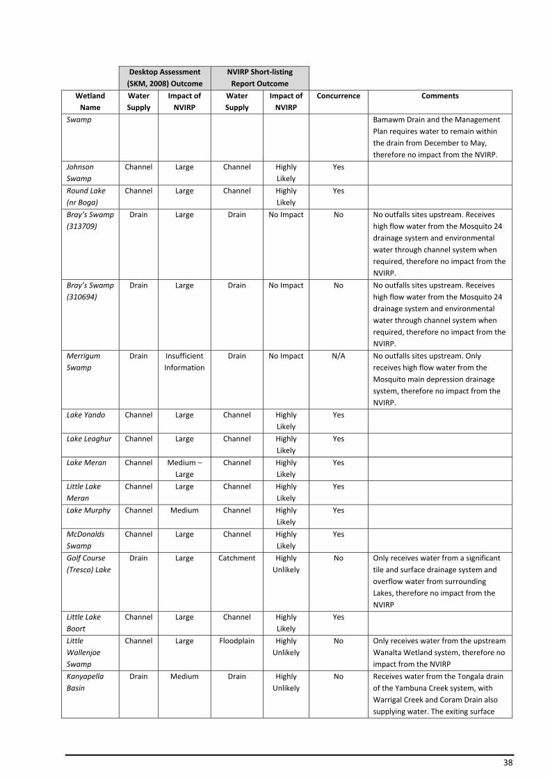
38
Desktop Assessment (SKM, 2008) Outcome
NVIRP Short‐listing Report Outcome
Wetland Name
Water Supply
Impact of NVIRP
Water Supply
Impact of NVIRP
Concurrence Comments
Swamp Bamawm Drain and the Management Plan requires water to remain within the drain from December to May, therefore no impact from the NVIRP.
Johnson Swamp
Channel Large Channel Highly Likely
Yes
Round Lake (nr Boga)
Channel Large Channel Highly Likely
Yes
Bray’s Swamp (313709)
Drain Large Drain No Impact No No outfalls sites upstream. Receives high flow water from the Mosquito 24 drainage system and environmental water through channel system when required, therefore no impact from the NVIRP.
Bray’s Swamp (310694)
Drain Large Drain No Impact No No outfalls sites upstream. Receives high flow water from the Mosquito 24 drainage system and environmental water through channel system when required, therefore no impact from the NVIRP.
Merrigum Swamp
Drain Insufficient Information
Drain No Impact N/A No outfalls sites upstream. Only receives high flow water from the Mosquito main depression drainage system, therefore no impact from the NVIRP.
Lake Yando Channel Large Channel Highly Likely
Yes
Lake Leaghur Channel Large Channel Highly Likely
Yes
Lake Meran Channel Medium – Large
Channel Highly Likely
Yes
Little Lake Meran
Channel Large Channel Highly Likely
Yes
Lake Murphy Channel Medium Channel Highly Likely
Yes
McDonalds Swamp
Channel Large Channel Highly Likely
Yes
Golf Course (Tresco) Lake
Drain Large Catchment Highly Unlikely
No Only receives water from a significant tile and surface drainage system and overflow water from surrounding Lakes, therefore no impact from the NVIRP
Little Lake Boort
Channel Large Channel Highly Likely
Yes
Little Wallenjoe Swamp
Channel Large Floodplain Highly Unlikely
No Only receives water from the upstream Wanalta Wetland system, therefore no impact from the NVIRP
Kanyapella Basin
Drain Medium Drain Highly Unlikely
No Receives water from the Tongala drain of the Yambuna Creek system, with Warrigal Creek and Coram Drain also supplying water. The exiting surface
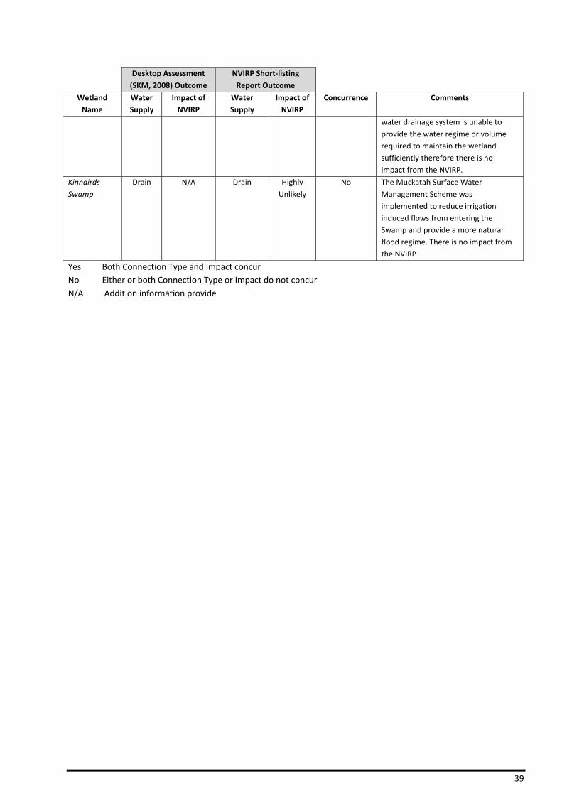
39
Desktop Assessment (SKM, 2008) Outcome
NVIRP Short‐listing Report Outcome
Wetland Name
Water Supply
Impact of NVIRP
Water Supply
Impact of NVIRP
Concurrence Comments
water drainage system is unable to provide the water regime or volume required to maintain the wetland sufficiently therefore there is no impact from the NVIRP.
Kinnairds Swamp
Drain N/A Drain Highly Unlikely
No The Muckatah Surface Water Management Scheme was implemented to reduce irrigation induced flows from entering the Swamp and provide a more natural flood regime. There is no impact from the NVIRP
Yes Both Connection Type and Impact concur No Either or both Connection Type or Impact do not concur N/A Addition information provide

40
7 Summary
7.1 Short‐list of Wetlands Impacted by Reduced Outfall
SKM (2008) states:
Of the 78 wetlands with high environmental values and medium to high potential impact from the NVIRP, a total of 23 were assessed as potentially impacted as a result of water regime changes associated with the NVIRP.
The 24 wetlands (23 preliminary listed in Desktop Assessment (SKM, 2008) plus 1 additional) in the GMID identified as being potentially impacted by the works to be undertaken by the NVIRP through the modernisation of the irrigation supply system have been assessed thorough this “ground truthing” investigation.
It has been concluded that the reduction of outfalls as a result of NVIRP’s modernisation works is highly likely or likely to impact the water supply of ten (10) of the nominated preliminary listed wetlands. NVIRP will be required to develop EWPs for these wetlands shown in Table 3.
Table 3: Short‐list of Wetlands Requiring an Environmental Watering Plan
Wetland Reference Number
Catchment Irrigation Area
Impact of NVIRP EWP Development
Lake Elizabeth 551457 NCCMA TIA Highly Likely 2009
Johnson Swamp 355320 NCCMA TIA Highly Likely 2009
Lake Murphy 587335 NCCMA TIA Highly Likely 2009
McDonalds Swamp 344450 NCCMA TIA Highly Likely 2010
Lake Yando 507077 NCCMA PBIA Highly Likely 2010
Lake Leaghur 524142 NCCMA PBIA Highly Likely 2010
Lake Meran 533258 NCCMA PBIA Highly Likely 2010
Little Lake Meran 541289 NCCMA PBIA Highly Likely 2010
Little Lake Boort 450990 NCCMA PBIA Highly Likely 2010
Round Lake (nr Boga) 366715 NCCMA TIA Highly Likely 2010* NCCMA – North Central Catchment Management Authority * TIA – Torrumbarry Irrigation Area * PBIA – Pyramid Boort Irrigation Area
7.2 Schedule of EWP Development
The scheduling of the development and approval of the EWPs is to be undertaken in relation to NVIRP’s program of works, so that the relevant EWPs can be in place prior to the operation of relevant works.
NVIRP is delivering its works through a series of annual programs as shown on the map in Appendix 5. The proposed schedule, in which the development of EWPs is required for the 10 short‐listed wetlands, has been included in Table 3.
The EWPs will be prepared prior to the completion of the program of works which are likely to adversely affect the wetland in that particular year.
7.3 Wetlands Not Impacted by Reduced Outfall
Fourteen (14) of 24 wetlands have been assessed as shown in Table 4 below as either
• not being supplied with channel outfall water, or
• have water supplied from other sources not impacted by channel outfalls.
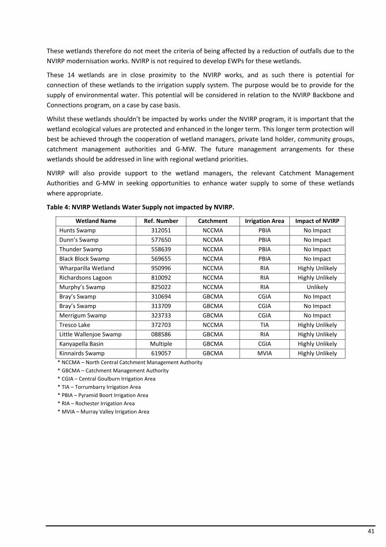
41
These wetlands therefore do not meet the criteria of being affected by a reduction of outfalls due to the NVIRP modernisation works. NVIRP is not required to develop EWPs for these wetlands.
These 14 wetlands are in close proximity to the NVIRP works, and as such there is potential for connection of these wetlands to the irrigation supply system. The purpose would be to provide for the supply of environmental water. This potential will be considered in relation to the NVIRP Backbone and Connections program, on a case by case basis.
Whilst these wetlands shouldn’t be impacted by works under the NVIRP program, it is important that the wetland ecological values are protected and enhanced in the longer term. This longer term protection will best be achieved through the cooperation of wetland managers, private land holder, community groups, catchment management authorities and G‐MW. The future management arrangements for these wetlands should be addressed in line with regional wetland priorities.
NVIRP will also provide support to the wetland managers, the relevant Catchment Management Authorities and G‐MW in seeking opportunities to enhance water supply to some of these wetlands where appropriate.
Table 4: NVIRP Wetlands Water Supply not impacted by NVIRP.
Wetland Name Ref. Number Catchment Irrigation Area Impact of NVIRP
Hunts Swamp 312051 NCCMA PBIA No Impact
Dunn’s Swamp 577650 NCCMA PBIA No Impact
Thunder Swamp 558639 NCCMA PBIA No Impact
Black Block Swamp 569655 NCCMA PBIA No Impact
Wharparilla Wetland 950996 NCCMA RIA Highly Unlikely
Richardsons Lagoon 810092 NCCMA RIA Highly Unlikely
Murphy’s Swamp 825022 NCCMA RIA Unlikely
Bray’s Swamp 310694 GBCMA CGIA No Impact
Bray’s Swamp 313709 GBCMA CGIA No Impact
Merrigum Swamp 323733 GBCMA CGIA No Impact
Tresco Lake 372703 NCCMA TIA Highly Unlikely
Little Wallenjoe Swamp 088586 GBCMA RIA Highly Unlikely
Kanyapella Basin Multiple GBCMA CGIA Highly Unlikely
Kinnairds Swamp 619057 GBCMA MVIA Highly Unlikely* NCCMA – North Central Catchment Management Authority * GBCMA – Catchment Management Authority * CGIA – Central Goulburn Irrigation Area * TIA – Torrumbarry Irrigation Area * PBIA – Pyramid Boort Irrigation Area * RIA – Rochester Irrigation Area * MVIA – Murray Valley Irrigation Area
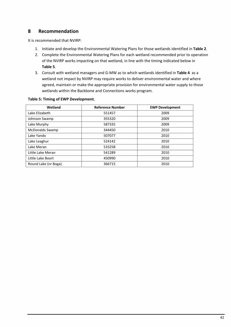
42
8 Recommendation
It is recommended that NVIRP:
1. Initiate and develop the Environmental Watering Plans for those wetlands identified in Table 2. 2. Complete the Environmental Watering Plans for each wetland recommended prior to operation
of the NVIRP works impacting on that wetland, in line with the timing indicated below in Table 5.
3. Consult with wetland managers and G‐MW as to which wetlands identified in Table 4 as a wetland not impact by NVIRP may require works to deliver environmental water and where agreed, maintain or make the appropriate provision for environmental water supply to those wetlands within the Backbone and Connections works program.
Table 5: Timing of EWP Development.
Wetland Reference Number EWP Development
Lake Elizabeth 551457 2009
Johnson Swamp 355320 2009
Lake Murphy 587335 2009
McDonalds Swamp 344450 2010
Lake Yando 507077 2010
Lake Leaghur 524142 2010
Lake Meran 533258 2010
Little Lake Meran 541289 2010
Little Lake Boort 450990 2010
Round Lake (nr Boga) 366715 2010
43
9 Glossary of Terminology
Allocation or Water Allocation Is the allocation of water for use in a particular irrigation season. Seasonal allocations will depend on how much water is available in storage.
Automation (Channel) A system of remotely controlled regulators and gates that are linked to a computerised system. The computerised system automates the ordering, delivery and measurement of supply in water irrigation channels. This automation may include customer service points.
Backbone The public irrigation supply infrastructure comprising of larger capacity water supply channels (carriers and trunks) that will form the nucleus of the water supply system. The backbone will be retained by Goulburn‐Murray Water at the end of the NVIRP.
Bulk Water Entitlement The right to water held by water and other authorities defined in the Water Act. The Bulk Water Entitlement defines the amount of water to which an authority is entitled from a river or storage, and may include the rate at which it may be taken and the reliability of the entitlement (MDBC, 2006). More recently this water right is called “Water Share”.
Channel Remediation The lining of the bed and banks of water supply channels or the rebuilding of channel bank to reduce water losses. Impermeable membranes or compacted clay may be used to line channels.
Channel Open channel or flume constructed to convey water from an upstream water source to farms.
Connections Public or private, piped or open channels, that allow individual properties, or a cluster of properties, to receive their water from the Backbone, in association with water supply changes agreed to with NVIRP (i.e. connected to the Backbone).
Culvert An underground structure or pipe carrying water beneath a road, carriageway etc.
Diversion Water extracted for use from waterways (including storages) by means of pumping or gravity channels.
Drainage Diversion A service that enables customers to pump or divert from a surface drain operated by a rural water delivery agency.
Drainage Channel An open channel or a modified natural waterway designed to remove excess water from rural lands
Drainage Network a collection network of carriers which is used to convey irrigation induced excess surface water or excess groundwater.
Drainage System System of open drainage channels, modified natural waterways and/or storages designed to collect drainage from rainfall and
irrigation runoff on rural lands and convey it to disposal. A system may include private, community and public works.
Environmental Assets include: water‐dependent ecosystems; and ecosystem services; and

44
sites with ecological significance Environmental Flow A water regime provided within a river, wetland or estuary to
improve or maintain ecosystems and their benefits where there are competing water uses and where flows are regulated.
Environmental Water Water allocated to support environmental outcomes and other public benefits. Environmental water provisions recognise the environmental water requirements and are based on environmental, social and economic considerations, including existing user rights.
Environmental Watering Plan Water supply protocol to protect the high environmental values of a wetland or waterway, which would otherwise be adversely affected without the additional management and mitigation measures set out in the Environmental Watering Plan.
Full Supply Level (FSL) Generally this is the level at which the storage starts to spill and corresponds to the maximum capacity for the storage. Sometimes the FSL may be set lower than the maximum capacity for dam safety reasons.
GMID Is the Goulburn Murray Irrigation District the water supply system operated by Goulburn Murray Water Corporation
Irrigation Area A defined part of an Irrigation District (i.e. GMID) Irrigation Diversion The volume of water extracted from waterways for irrigation
purposes. The volume includes all losses incurred from when the water is diverted from the river or reservoir until it is delivered to the farm gate.
Leakage Loss of water through the banks of a channel (and around Service Points) via macro‐pores.
Landholder The landowner with consent of lessees and mortgagees where appropriate.
Land Manager Entity responsible for managing environmental assets at a site. Metered Those customers supplied with water through a meter which
measurements volume and flow rate. Modernisation The program of works that will result in an automated backbone,
accurate metering and minimisation of water losses. Offtake May be at the beginning or internal to a water delivery system and
is defined as the beginning of a channel diverting water from a water source or the backbone.
Outfall Structure A structure which allows surplus water to be safely spilled from a water supply channel. Outfall sites are also measuring sites in the water supply system below which no water delivery orders are place or water is delivered to customers. Water may still be delivered to customers downstream of the outfall through a drainage diversion licence.
Outfall Water The volume of water passed through channel system outfall structures or escapes.
45
Primary Drain Are surface drains, owned, operated and maintained by G‐MW. The drains are designed to a consistent standard, which generally means the drains are open earthen channels with a trapezoidal section.
Rationalise In the context of a backbone infrastructure, rationalise generally means to remove/decommission the structure in question. In the context of all other infrastructure not associated with the backbone (e.g. spur channels), rationalise generally means decommissioning or transfer into private ownership. Where decommissioning occurs and is undertaken by NVIRP, the works will be managed through the Capital Works Component of the Construction Environmental Management Framework.
Reconfiguration Is an integral step in the modernisation program whereby appropriate planning occurs, redundant infrastructure is identified and customers are involved in the process of determining how these assets can be decommissioned.
Regulator A permanent structure constructed across a channel and fitted with a means of adjusting the waterway area so as to control both the rate of water flow along the channel and/or the upstream water level.
Runoff Flow of surface water from a given area resulting from the effects of rainwater and/or applied irrigation water in excess of crop water requirement and leaching.
SCADA Supervisory Control and Data Acquisition process using dedicated computer equipment and purpose written software to monitor and control remote irrigation sites from a centralised office.
Seepage Water lost through micro pores in channel beds and banks in earthen channel systems.
Siphon Structure or section of pipeline that conveys channel flow under a natural depression, river or drain.
Spur (or lateral) channel Irrigation supply infrastructure not associated with the backbone. Subway Conduit laid transversely under supply channel to convey natural
drainage flows across the channel. Supply Point (Farm Offtake/Outlet) Point of delivery from an irrigation corporation supply system to an
individual farm. A supply point from a channel system usually comprises a small gated regulator or pipe outfall which may incorporate a measurement device (meter).
Surface Water Management Are community drains that are generally smaller than Scheme primary drains and serve smaller catchments. They can outfall to
natural watercourses or primary drains. Tailwater Flow of surface water from a given area resulting from the effects
of applied irrigation water in excess of crop water requirement and leaching.
Un‐metered Water users who received water through an unmetered water supply point. Billing volumes are usually determined by deeming or rule of thumb calculations.
46
Water Share (Entitlement) A legally recognised, secure share of the water, in storage or yielded in the catchment, available for use from a water system. The Entitlement volume can be traded either temporarily or permanently:
• High Reliability Water Share: The share of the high reliability water pool. This volume has been converted from existing water right or diversion licence volume. (e.g. 100 ML of water right becomes 100 ML of high‐reliability water share). Seasonal allocations will depend on how much water is available in storage. If a seasonal water allocation during a drought was only 50%, an entitlement holder with a 100 ML high‐reliability water share would be allocated 50 ML of water for use.
• Low Reliability Water Share: The share of the low reliability water pool.
Weir A structure in a waterway or drain to facilitate regulation of flow or diversion to storages , supply networks or wetlands.
Wetlands Areas of marsh, fern, parkland or water, whether natural or artificial, permanent or temporary, with water that is static or flowing fresh, brackish or salt, including areas of marine water, the depth of which at low tide does not exceed 6 metres.
47
10 References
1. DCNR (1996) Wetland Management Strategy – Lake Elizabeth, Kerang, Department of Conservation and Natural Resources
2. DNRE (2002) Little Lake Boort Flushing Strategy, Department of Natural Resources and Environment
3. DPI (2001) Bray’s Swamp Wetland Management Plan, Department of Primary Industries 4. DPI (2007) Kanyapella Basin Environmental Management Plan, Department of Primary Industries and
Goulbourn Broken Catchment Management Authority
5. DSE (2004) Kerang Wetlands Ramsar Site ‐ Strategic Management Plan, Department of Sustainability and Environment
6. DPI (2003) Kinnairds Wetland Environmental Management Plan, Department of Primary Industries
7. DSE (2008) Northern Victoria Irrigation Renewal Project ‐ Draft Business Case, Department of Sustainability and Environment
8. DSE (2009) Northern Victoria Irrigation Renewal Project – Government Referral Document, Department of Sustainability and Environment
9. DSE (2008). Interactive Maps Website (WC Base Maps & Victorian Water Resources Maps), Department of Sustainability and Environment
10. DSE (2004) Victorian Government White Paper – Securing out Water Future Together – Our Water, Our Future, Department of Sustainability and Environment
11. Ecos (2006) Meran Lakes Complex Water Operation Plan – Environmental Values Assessment, Ecos Environmental Consulting
12. ECOS (2007) Boort District Wetlands Vegetation Assessment, Ecos Environmental Consulting 13. GHD (2006) DRAFT Meran Lakes Complex Water Operational Plan – Surface Water Management
Investigation, GHD 14. G‐MW (2002) Operational Guidelines for the Pump and Little Lake Boort, Goulburn ‐ Murray Water 15. Macumber (2007) Lake Elizabeth Operational Plans and Management Options – The Implications for
Lake Level and Salinity, Phillip Macumber Consulting Services for DPI
16. NVIRP (2009) Business Case Stage 1 –Volume 1 (Final), Northern Victoria Irrigation Renewal Project 17. NVIRP (2009a) Water Change Management Framework, Northern Victoria Irrigation Renewal Project 18. NWC (2009) Water Dictionary, National Water Commission. 19. SKM (1999). Richardsons Lagoon and Murphy’s Swamp Environmental Management Plan, Sinclair
Knight Merz
20. SKM (2001a) Johnsons Swamp Water and Operational Plan, Sinclair Knight Merz 21. SKM (2001b) Mc Donald Swamp Watering and Operation Plan, Sinclair Knight Merz 22. SKM (2001c) Lake Leaghur Environmental Assessment, Sinclair Knight Merz 23. SKM (2008). Food Bowl Modernisation Project –Environmental Referrals, Sinclair Knight Merz for DSE 24. SKM (2008a) Preliminary Determination of Groundwater Effects, Sinclair Knight Merz for NVIRP 25. Consultation with G‐MW, DPI, CMA and DSE staff.
48
11 Appendix 1 Validation and Scheduling of Wetlands Requiring EWPs (WCMF – Attachment C)
Objective
To carry out a validation on the identified preliminary list of wetlands (known as having high environmental values and receiving incidental irrigation water which will be reduced by modernisation), to confirm the existing sources of water for these wetlands.
Wetlands where significant impacts are likely from implementation of NVIRP will be recommended for further, more detailed investigation, or development of an Environmental Watering Plan (EWP).
Process
A three step process will be used to confirm the source(s) of water supply to the identified wetlands and assess the potential impact to wetlands in the GMID as result of the NVIRP. The process will involve the following steps:
1. Site Inspection and collate data to confirm source(s) of water supply to wetland 2. Analysis of data collated and confirm the wetlands which receive water from
incidental irrigation water 3. Identification requirement and scheduling for development of Environmental
Watering Plans Note: Additional analyses will be undertaken as part of the groundwater/salinity report to ascertain the potential of other pathways of NVIRP influence on wetlands. Where the groundwater/salinity study indicates a significant impact due to other sources on high environmental values, appropriate mitigation measures will be developed consistent with the principles set out in Section 9 of the WCMF.
Output
A list of wetlands with high environmental values that a reduction of incidental irrigation water will adversely impact their hydrological regime:
• recommended for development of an Environmental Watering Plan
• required scheduling of EWP development. Methodology
Site Inspection and Data Collation
Undertake a site inspection of each wetland and consult with relevant stakeholders to gather the following information to confirm the current source(s) of water for each wetland and the infrastructure utilised.
1. Determine the following:
• How is the wetland supplied by water? Channel / Drain / Farm Channel / Groundwater or otherwise
• Is the connection direct and/or indirect?
• If channel (G‐MW Asset) identify: o channel number o channel outfall or a supply point (metered / unmetered) for controlled input
into wetland. Supply Point number
49
o volume of water outfalled or provided to wetland in 2004/05 (ML) or through EWA's
o Is outfall structure / supply point on the NVIRP Backbone, if not what distance from the backbone and what is the path of that connection and what number of landholders are involved.
• If drain identify: o drain type – primary or community drain or private drain o date drain was constructed and current management arrangement (G‐MW /
local government or private landholder) o how does water enter / exit the wetland? ie restriction in drain to force high
flows over spillway into wetland with outlet further downstream on drain or to a waterway, drain with no banks passes through wetland, water spreads out, etc.
o drain restriction,(gate, pipe other form of restriction) wetland inlet and outlet type,(spillway / pipe etc) capacity & dimensions (design drawings, field measurement) Height and level of the structures if available from drawings
o number of channel outfall structures upstream of wetland
outfall volume in 2004/05 for each outfall structure
o number of drain diverters between outfall structures and wetland
diverter license volume and whether high or low flow diverter reuse system volume (what further allocation / diversion licenses are likely
to be allocated ie. What volume is unallocated)
o what was original source of water prior to drain being constructed
• If not supplied from G‐MW assets, then where from or how?
• Does the wetland have a formal or draft management plan or any informal / local requirements? Obtain copy of management plan if available (CMA’s) or any environmental assessments recommendations for the wetland.
• For those wetlands with Management Plans, what is the required water regime and annual volume of water? (use EWA water volume calculation to describe)
• Is there an alternative source of water nearby? Identify any works and structures required to be able to deliver the water.
• When was water last in the wetland? What was the source of this water? eg channel outfall/ rainfall.
2. Take photos of wetland features, inlet and outlet works and the channel outfall, restrictions.
3. Obtain design drawings / plans, if available from G‐MW / CMA / DPI / Local Government
Analysis The data collated will be analysed to determine the impact that NVIRP will have upon water supply provision to the wetlands.
1. Undertake analysis to determine whether the existing water supply for each nominated wetland is sourced from channel outfalls.
‐ Utilise the data collated, supplemented by the desktop study, existing environment or water plans and assessments, the DSE Interactive Map website, and consultation with G‐MW operations staff to identify the current source of water for each wetland.
50
‐ Confirm if outfall water is a source of water supply for the wetland; and ‐ Identify if outfall water is utilised for other purposes eg diversion for irrigated
production, or other site/use, passing or environmental flow.
2. confirm whether or not the NVIRP would impact on that water supply Environmental Watering Plans Determine the requirement for development of EWPs for wetlands with known high environmental values and which receive a significant proportion of their water supply from incidental irrigation water. Identify the required schedule for development of the EWPs based on the requirements and the proposed NVIRP program of works. Reporting Prepare a report:
1. presenting results 2. recommending wetlands requiring further investigation 3. recommending wetlands requiring an EWP 4. identifying the required schedule for the development of each EWP.
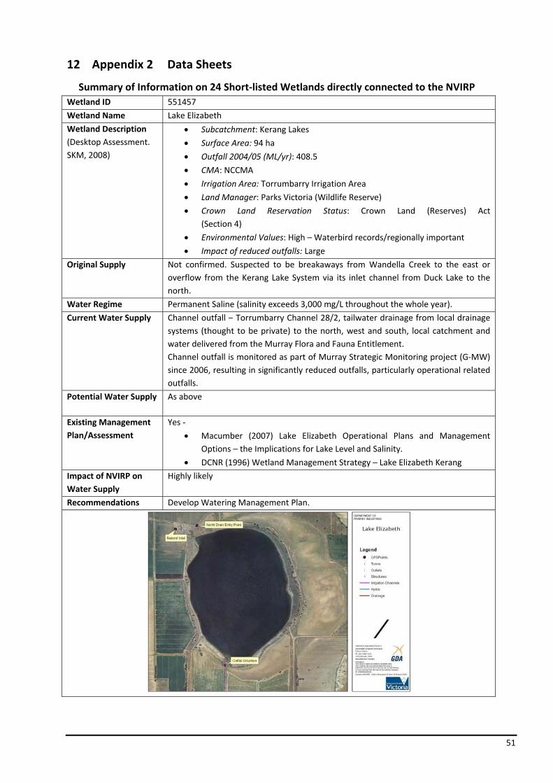
51
12 Appendix 2 Data Sheets
Summary of Information on 24 Short‐listed Wetlands directly connected to the NVIRP Wetland ID 551457
Wetland Name Lake Elizabeth
Wetland Description (Desktop Assessment. SKM, 2008)
• Subcatchment: Kerang Lakes
• Surface Area: 94 ha
• Outfall 2004/05 (ML/yr): 408.5
• CMA: NCCMA
• Irrigation Area: Torrumbarry Irrigation Area
• Land Manager: Parks Victoria (Wildlife Reserve)
• Crown Land Reservation Status: Crown Land (Reserves) Act (Section 4)
• Environmental Values: High – Waterbird records/regionally important
• Impact of reduced outfalls: Large
Original Supply Not confirmed. Suspected to be breakaways from Wandella Creek to the east or overflow from the Kerang Lake System via its inlet channel from Duck Lake to the north.
Water Regime Permanent Saline (salinity exceeds 3,000 mg/L throughout the whole year).
Current Water Supply Channel outfall – Torrumbarry Channel 28/2, tailwater drainage from local drainage systems (thought to be private) to the north, west and south, local catchment and water delivered from the Murray Flora and Fauna Entitlement. Channel outfall is monitored as part of Murray Strategic Monitoring project (G‐MW) since 2006, resulting in significantly reduced outfalls, particularly operational related outfalls.
Potential Water Supply As above
Existing Management Plan/Assessment
Yes ‐
• Macumber (2007) Lake Elizabeth Operational Plans and Management Options – the Implications for Lake Level and Salinity.
• DCNR (1996) Wetland Management Strategy – Lake Elizabeth Kerang
Impact of NVIRP on Water Supply
Highly likely
Recommendations Develop Watering Management Plan.

52
Wetland ID 312051
Wetland Name Hunt’s Swamp
Wetland Description (Desktop Assessment. SKM, 2008)
• Subcatchment: Calivil Creek (located on a tributary that flows north west into the creek)
• Surface Area: 61 ha
• Outfall 2004/05 (ML/yr): 0
• CMA: NCCMA
• Irrigation Area: Pyramid Boort Irrigation Area
• Land Manager: Private (David Broad)
• Crown Land Reservation Status: N/A
• Environmental Values: High – Brolga habitat, plus other Waterbirds, Lignum dominant
• Impact of reduced outfalls: None
Original Supply Not confirmed. Likely to be runoff from within its own catchment and overflow from Calivil and Bullock Creek system during flood periods, from the south of the Swamp. Supported by the location of large road culvert structure to the south of the Swamp.
Water Regime Shallow Freshwater Marsh – Usually dry by mid‐summer and fill again with the onset of winter rains. Soils are waterlogged throughout the year and surface water up to 0.5 m deep may be present for as long as eight months.
Current Water Supply No outfall received. Local catchment and from runoff and irrigation tailwater via CSD running through the swamp from the south. Also drainage point for local runoff via subway ST9161 under channel 3/20/1.
Potential Water Supply Could fill from Channel 3/20/1 via supply point 1124. Anecdotally, the G‐MW Field Operators have indicated that it has been supplied water through the supply point in the past but it is at least 25 years since water was last supplied.
Existing Management Plan/Assessment
No
Impact of NVIRP on Water Supply
No impact
Recommendations No further action required by NVIRP.

53
Wetland ID 577650
Wetland Name Dunn’s Swamp
Wetland Description (Desktop Assessment. SKM, 2008)
• Subcatchment: Pyramid Creek (Myers and Bendigo Creek)
• Surface Area: 35 ha
• Outfall 2004/05 (ML/yr): 0
• CMA: NCCMA
• Irrigation Area: Pyramid Boort Irrigation Area
• Land Manager: Private
• Crown Land Reservation Status: N/A
• Environmental Values: Unknown – Record of Barking March Frog
• Impact of reduced outfalls: None
Original Supply Part of a depression system of the Myers Creek Depression, historically received water from active floodplain. Now partly isolated by land forming and cultivation.
Water Regime Shallower sections with Black Box regeneration Type 2 – Annually most years in winter/spring for 1 – 4 months. Deeper section with dead stags Type 3 – Annually most years in winter/spring for 4 – 6 months duration. Swamp watering regime has been manipulated with a privately constructed drainage network to allow faster draining of the Swamp towards the north west outlet.
Current Water Supply No outfall received. Swamp fills from natural runoff collected by a network of new road culverts at the south east corner (Tandarra – Elmore Road and Dunn’s Road intersection). Private drainage system through Swamp installed in the 1980’s, which drains to north of Swamp to Myers Creek. Does not have channel delivery connection.
Potential Water Supply Waranga Western Main Channel 1000m to east.
Existing Management Plan/Assessment
No
Impact of NVIRP on Water Supply
No impact
Recommendations No further action required by NVIRP.

54
Wetland ID 558639
Wetland Name Thunder Swamp
Wetland Description (Desktop Assessment. SKM, 2008)
• Subcatchment: Pyramid Creek
• Surface Area: 60 ha
• Outfall 2004/05 (ML/yr): 0
• CMA: NCCMA
• Irrigation Area: Pyramid Boort Irrigation Area
• Land Manager: Parks Victoria (Wildlife Reserve)
• Crown Land Reservation Status: Crown Land (Reserves) Act (S. 4)
• Environmental Values: High – Waterbird records/regionally important
• Impact of reduced outfalls: None
Original Supply Part of a depression system of the Myers Creek Depression, now partly isolated by land forming and cultivation. It is a shallow basin located adjacent to Myers Creek with a natural inlet and outlet. The Swamp would receive natural flows in flood events from Myers Creek.
Water Regime Seasonal saturation, intermittent short duration and shallow flooding. Flooding < 1 in 2 years in winter/early spring for 1 month.
Current Water Supply No outfall, runoff from local catchment area (Myers Creek). Myers Creek flows through the “Thunder Syphon” (ST 29691) on the Waranga Western Channel located to the south east of the Swamp. There is also a subway under the channel west of the “Thunder Syphon”.
Potential Water Supply Waranga Western main channel transects from east to west 270m to the south of Thunder Swamp.
Impact of NVIRP on Water Supply
No impact
Existing Management Plan/Assessment
No
Recommendations No further action required by NVIRP.
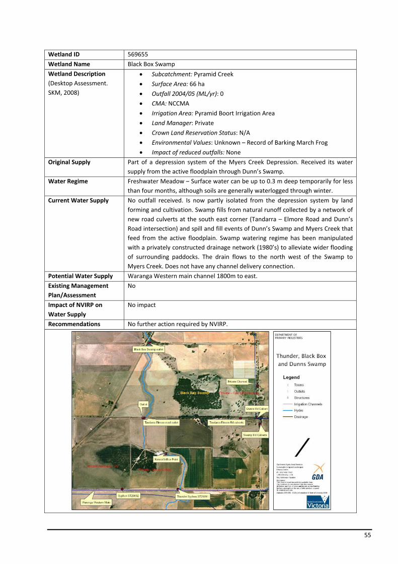
55
Wetland ID 569655
Wetland Name Black Box Swamp
Wetland Description (Desktop Assessment. SKM, 2008)
• Subcatchment: Pyramid Creek
• Surface Area: 66 ha
• Outfall 2004/05 (ML/yr): 0
• CMA: NCCMA
• Irrigation Area: Pyramid Boort Irrigation Area
• Land Manager: Private
• Crown Land Reservation Status: N/A
• Environmental Values: Unknown – Record of Barking March Frog
• Impact of reduced outfalls: None
Original Supply Part of a depression system of the Myers Creek Depression. Received its water supply from the active floodplain through Dunn’s Swamp.
Water Regime Freshwater Meadow – Surface water can be up to 0.3 m deep temporarily for less than four months, although soils are generally waterlogged through winter.
Current Water Supply No outfall received. Is now partly isolated from the depression system by land forming and cultivation. Swamp fills from natural runoff collected by a network of new road culverts at the south east corner (Tandarra – Elmore Road and Dunn’s Road intersection) and spill and fill events of Dunn’s Swamp and Myers Creek that feed from the active floodplain. Swamp watering regime has been manipulated with a privately constructed drainage network (1980’s) to alleviate wider flooding of surrounding paddocks. The drain flows to the north west of the Swamp to Myers Creek. Does not have any channel delivery connection.
Potential Water Supply Waranga Western main channel 1800m to east.
Existing Management Plan/Assessment
No
Impact of NVIRP on Water Supply
No impact
Recommendations No further action required by NVIRP.
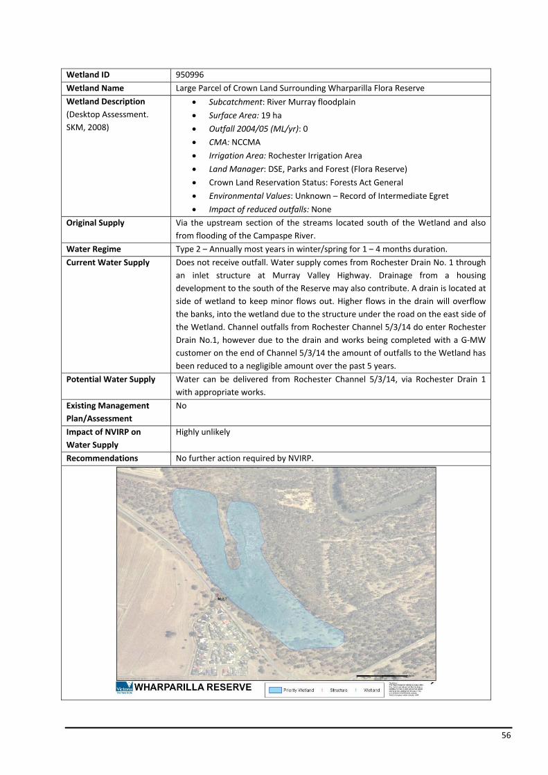
56
Wetland ID 950996
Wetland Name Large Parcel of Crown Land Surrounding Wharparilla Flora Reserve
Wetland Description (Desktop Assessment. SKM, 2008)
• Subcatchment: River Murray floodplain
• Surface Area: 19 ha
• Outfall 2004/05 (ML/yr): 0
• CMA: NCCMA
• Irrigation Area: Rochester Irrigation Area
• Land Manager: DSE, Parks and Forest (Flora Reserve)
• Crown Land Reservation Status: Forests Act General
• Environmental Values: Unknown – Record of Intermediate Egret
• Impact of reduced outfalls: None
Original Supply Via the upstream section of the streams located south of the Wetland and also from flooding of the Campaspe River.
Water Regime Type 2 – Annually most years in winter/spring for 1 – 4 months duration.
Current Water Supply Does not receive outfall. Water supply comes from Rochester Drain No. 1 through an inlet structure at Murray Valley Highway. Drainage from a housing development to the south of the Reserve may also contribute. A drain is located at side of wetland to keep minor flows out. Higher flows in the drain will overflow the banks, into the wetland due to the structure under the road on the east side of the Wetland. Channel outfalls from Rochester Channel 5/3/14 do enter Rochester Drain No.1, however due to the drain and works being completed with a G‐MW customer on the end of Channel 5/3/14 the amount of outfalls to the Wetland has been reduced to a negligible amount over the past 5 years.
Potential Water Supply Water can be delivered from Rochester Channel 5/3/14, via Rochester Drain 1 with appropriate works.
Existing Management Plan/Assessment
No
Impact of NVIRP on Water Supply
Highly unlikely
Recommendations No further action required by NVIRP.
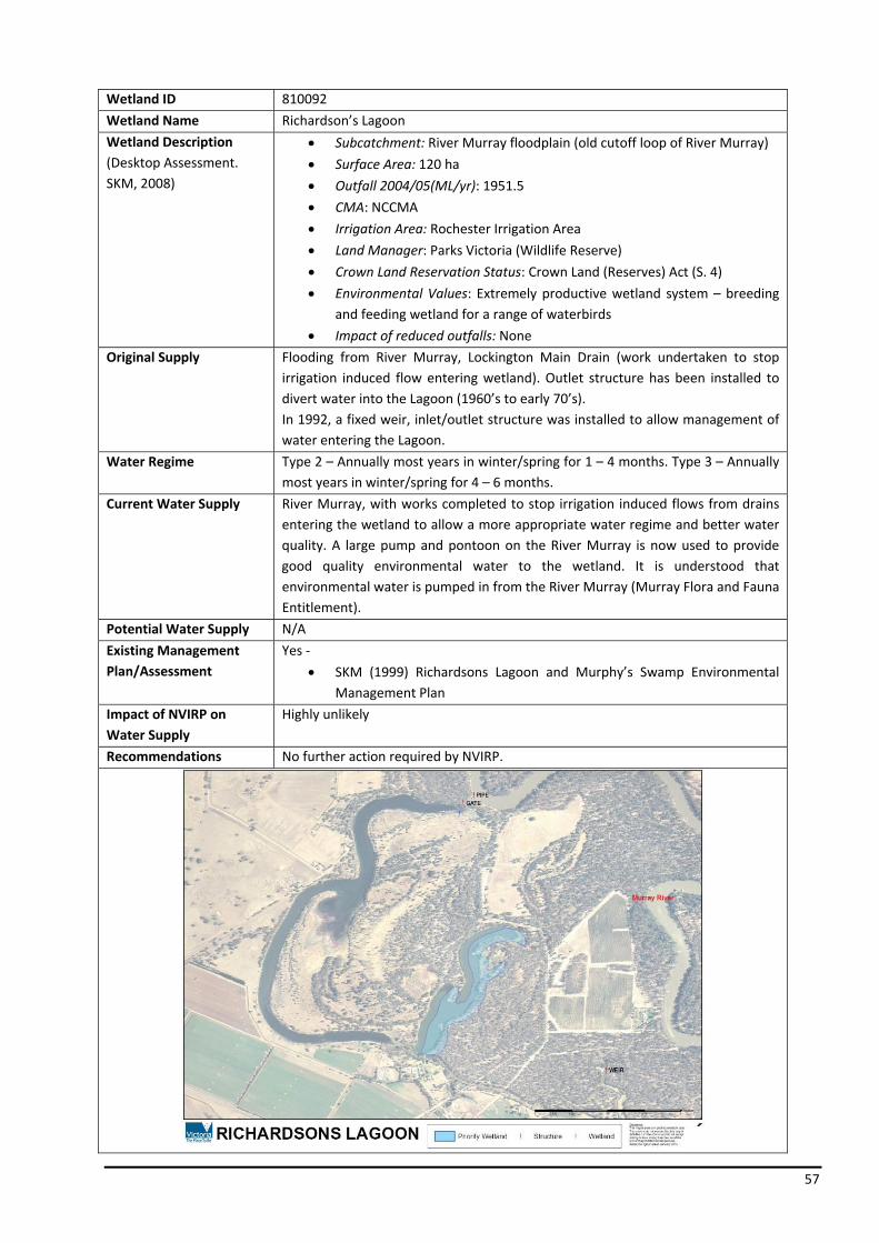
57
Wetland ID 810092
Wetland Name Richardson’s Lagoon
Wetland Description (Desktop Assessment. SKM, 2008)
• Subcatchment: River Murray floodplain (old cutoff loop of River Murray)
• Surface Area: 120 ha
• Outfall 2004/05(ML/yr): 1951.5
• CMA: NCCMA
• Irrigation Area: Rochester Irrigation Area
• Land Manager: Parks Victoria (Wildlife Reserve)
• Crown Land Reservation Status: Crown Land (Reserves) Act (S. 4)
• Environmental Values: Extremely productive wetland system – breeding and feeding wetland for a range of waterbirds
• Impact of reduced outfalls: None
Original Supply Flooding from River Murray, Lockington Main Drain (work undertaken to stop irrigation induced flow entering wetland). Outlet structure has been installed to divert water into the Lagoon (1960’s to early 70’s). In 1992, a fixed weir, inlet/outlet structure was installed to allow management of water entering the Lagoon.
Water Regime Type 2 – Annually most years in winter/spring for 1 – 4 months. Type 3 – Annually most years in winter/spring for 4 – 6 months.
Current Water Supply River Murray, with works completed to stop irrigation induced flows from drains entering the wetland to allow a more appropriate water regime and better water quality. A large pump and pontoon on the River Murray is now used to provide good quality environmental water to the wetland. It is understood that environmental water is pumped in from the River Murray (Murray Flora and Fauna Entitlement).
Potential Water Supply N/A
Existing Management Plan/Assessment
Yes ‐
• SKM (1999) Richardsons Lagoon and Murphy’s Swamp Environmental Management Plan
Impact of NVIRP on Water Supply
Highly unlikely
Recommendations No further action required by NVIRP.

58
Wetland ID 825022+
Wetland Name Murphy’s Swamp
Wetland Description (Desktop Assessment. SKM, 2008)
• Subcatchment: Lockington Bamawm Drainage system
• Surface Area: 88.4 ha
• Outfall 2004/05 (ML/yr): 1594.5
• CMA: NCCMA
• Irrigation Area: Rochester Irrigation Area
• Land Manager: Parks Victoria and G‐MW (Wildlife Reserve/ Water Board Reserve)
• Crown Land Reservation Status: Forests Act General
• Environmental Values: High – Waterbird records – Australasian Shoveller, Brolga, Freckled Duck, Hardhead, Latham’s Snipe
• Impact of reduced outfalls: None
Original Supply Runoff from the Bamawm Depression to the south of the wetland.
Water Regime Type 1 – Seasonal flooding less than 1 in 2 years in winter/early spring for < 1 month duration. Type 3 – Annually most years in winter/spring for 1 – 4 months. The water regime recommended to encourage a diverse range of aquatic plants is; June to August – no boards, September to November – 1/3 inundation of the swamp, December to May – Hold water only in the drain.
Current Water Supply Any water received is via the G‐MW Bamawm Primary Water Management System (PSWMS). The water supply for Murphy’s Swamp comes from drainage (tailwater and outfall) in the irrigation season and rainfall runoff in the winter/spring. Works in the drain, include a weir and a number of overflow sills (not formalised; only cuts in drain banks) that force water into the swamp. Environmental Management plan recommends Swamp should remain dry, with water restricted within the drain from Dec to May.
Potential Water Supply N/A
Existing Management Plan/Assessment
Yes ‐ SKM (1999) Richardsons Lagoon and Murphy’s Swamp Environmental Management Plan.
Impact of NVIRP on Water Supply
Unlikely
Recommendations No further action required by NVIRP.
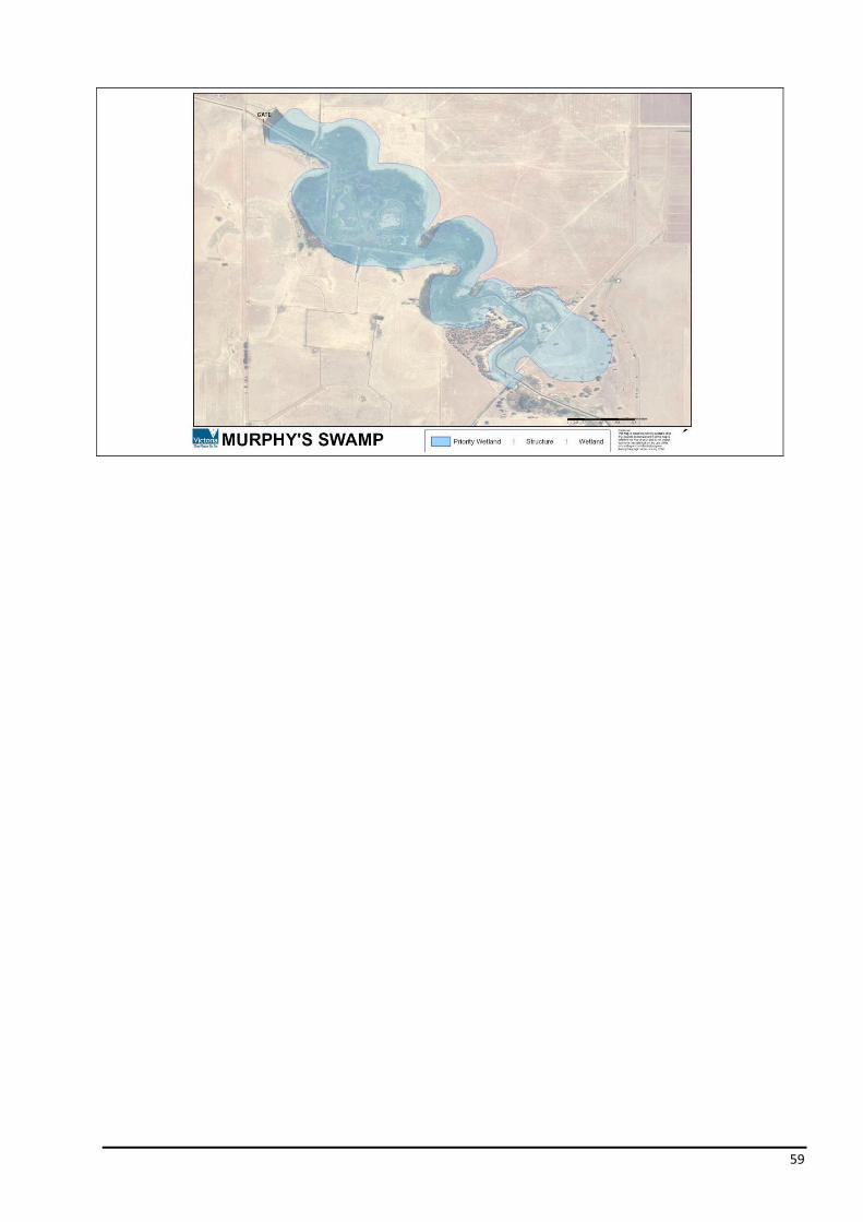
59

60
Wetland ID 355320
Wetland Name Johnson Swamp
Wetland Description (Desktop Assessment. SKM, 2008)
• Subcatchment: Pyramid Creek
• Surface Area: 441 ha
• Outfall 2004/05 (ML/yr): 72.25
• CMA: NCCMA
• Irrigation Area: Torrumbarry Irrigation Area
• Land Manager: Parks Victoria (Wildlife Reserve)
• Crown Land Reservation Status: Crown Land (Reserves) Act (S. 4)
• Environmental Values: Very high – Ramsar listed
• Impact of reduced outfalls: Large
Original Supply Pyramid Creek, which originally flowed through the Swamp, intermittently flooded the Swamp. During 1920’s with the advent of irrigation the Swamp was permanently inundated. Dredging of Pyramid Creek in 1967 resulted in the Johnson Swamp being divided into two and removed from its natural water supply, resulting in flood flows to now only enter the wetland in major floods. Currently the Swamp can only be naturally inundated during major flood events.
Water Regime Deep Freshwater Marsh – Generally remain inundated to a depth of 1 – 2 m throughout the year (permanent).
Current Water Supply Channel outfall – Torrumbarry 4/7/2. It is understood that the water passed through the outfall is from rainfall induced outfall and the delivery of environmental water. There is provision to prevent rainfall induced outfall. Some drainage from tailwater also enters the Swamp. The Swamp can now only be naturally inundated during major flood events. In 1987 the Swamp received 2600 ML of environmental water, shared with Hird Swamp. Understood that water passing through the outfall structure is predominately from the Murray Flora and Fauna Entitlement and partly from rainfall induced outfall. Operational outfalls bypass the Swamp directly into Pyramid Creek which allows the water to be delivered or stored for productive use, further downstream. Swamp dry since March 2002.
Potential Water Supply Water can be delivered via Channel 4/7/2 on successful application of an Environmental Water Allocation as was the case in 2000.
Existing Management Plan/Assessment
Yes ‐SKM (2001) Johnsons Swamp Water and Operational Plan
Impact of NVIRP on Water Supply
Highly likely
Recommendations Develop Water Management Plan.
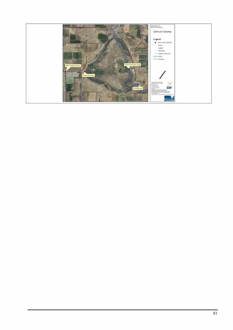
61
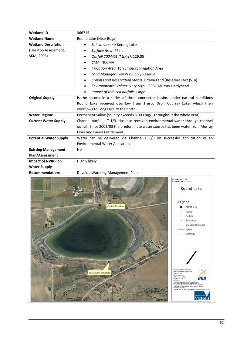
62
Wetland ID 366715
Wetland Name Round Lake (Near Boga)
Wetland Description (Desktop Assessment. SKM, 2008)
• Subcatchment: Kerang Lakes
• Surface Area: 42 ha
• Outfall 2004/05 (ML/yr): 129.05
• CMA: NCCMA
• Irrigation Area: Torrumbarry Irrigation Area
• Land Manager: G‐MW (Supply Reserve)
• Crown Land Reservation Status: Crown Land (Reserves) Act (S. 4)
• Environmental Values: Very high – EPBC Murray Hardyhead
• Impact of reduced outfalls: Large
Original Supply Is the second in a series of three connected basins, under natural conditions Round Lake received overflow from Tresco (Golf Course) Lake, which then overflows to Long Lake to the north.
Water Regime Permanent Saline (salinity exceeds 3,000 mg/L throughout the whole year).
Current Water Supply Channel outfall – T 1/9. Has also received environmental water through channel outfall. Since 2002/03 the predominate water source has been water from Murray Flora and Fauna Entitlement.
Potential Water Supply Water can be delivered via Channel T 1/9 on successful application of an Environmental Water Allocation.
Existing Management Plan/Assessment
No
Impact of NVIRP on Water Supply
Highly likely
Recommendations Develop Watering Management Plan.

63
Wetland ID 310694
Wetland Name Bray’s Swamp
Wetland Description (Desktop Assessment. SKM, 2008)
• Subcatchment: Mosquito
• Surface Area: 24 ha
• Outfall 2004/05 (ML/yr): 0
• CMA: GBCMA
• Irrigation Area: Central Goulburn Irrigation Area
• Land Manager: Private
• Crown Land Reservation Status: N/A
• Environmental Values: High – Brolga habitat
• Impact of reduced outfalls: None
Original Supply Runoff from the Byrneside Mosquito Depression.
Water Regime Southern section Type 1 – Seasonal flooding less than 1 in 2 years in winter/early spring for < 1 month duration. Southern section Type 2 – Annually most years in winter/spring for 1 – 4 months. Northern section Type 3 – Annually most years in winter/spring for 4 – 6 months. Northern section Type 3 – Annually most years in winter/spring/early summer for 6 – 10 months.
Current Water Supply Mosquito 24 SWMS drain constructed in 1996. A serries of rock sills in the drain operate only during high flow events (> 75 ML/d). Originally water forced over the sills by provision of a choke downstream of each sill, due to dry conditions since the drain implementation, it is understood that the chokes have been replace with gate structures to ensure delivery of water regime. There are no channel outfall sites on the Mosquito 24 Drain upstream of the Swamp. It is understood that G‐MW has undertaken works to the landholders internal supply system to allow water to be supplied from the GC No.8 Channel. Environmental water (Murray Flora and Fauna Entitlement and Stockyard Plain Entitlement) was delivered to the Swamp through these works in 2004/05.
Potential Water Supply Water can be delivered via Channel 8 on the successful application of an Environmental Water Allocation as the case in 2004/05 and 2005/06.
Existing Management Plan/Assessment
Yes ‐
• DPI (2001) Bray’s Swamp Wetland Management Plan
• Surface Water Management Schemes: Mosquito 24 Primary Scheme – has been designed to provide effective drainage from the catchment over a five day period in the event of a 1 in 2 year rainfall event.
Impact of NVIRP on Water Supply
Highly unlikely
Recommendations No further action required by NVIRP.

64
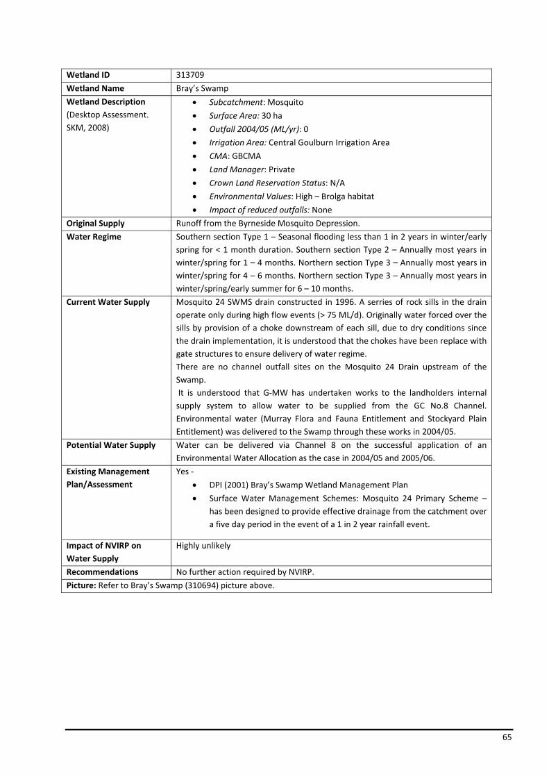
65
Wetland ID 313709
Wetland Name Bray’s Swamp
Wetland Description (Desktop Assessment. SKM, 2008)
• Subcatchment: Mosquito
• Surface Area: 30 ha
• Outfall 2004/05 (ML/yr): 0
• Irrigation Area: Central Goulburn Irrigation Area
• CMA: GBCMA
• Land Manager: Private
• Crown Land Reservation Status: N/A
• Environmental Values: High – Brolga habitat
• Impact of reduced outfalls: None
Original Supply Runoff from the Byrneside Mosquito Depression.
Water Regime Southern section Type 1 – Seasonal flooding less than 1 in 2 years in winter/early spring for < 1 month duration. Southern section Type 2 – Annually most years in winter/spring for 1 – 4 months. Northern section Type 3 – Annually most years in winter/spring for 4 – 6 months. Northern section Type 3 – Annually most years in winter/spring/early summer for 6 – 10 months.
Current Water Supply Mosquito 24 SWMS drain constructed in 1996. A serries of rock sills in the drain operate only during high flow events (> 75 ML/d). Originally water forced over the sills by provision of a choke downstream of each sill, due to dry conditions since the drain implementation, it is understood that the chokes have been replace with gate structures to ensure delivery of water regime. There are no channel outfall sites on the Mosquito 24 Drain upstream of the Swamp. It is understood that G‐MW has undertaken works to the landholders internal supply system to allow water to be supplied from the GC No.8 Channel. Environmental water (Murray Flora and Fauna Entitlement and Stockyard Plain Entitlement) was delivered to the Swamp through these works in 2004/05.
Potential Water Supply Water can be delivered via Channel 8 on the successful application of an Environmental Water Allocation as the case in 2004/05 and 2005/06.
Existing Management Plan/Assessment
Yes ‐
• DPI (2001) Bray’s Swamp Wetland Management Plan
• Surface Water Management Schemes: Mosquito 24 Primary Scheme – has been designed to provide effective drainage from the catchment over a five day period in the event of a 1 in 2 year rainfall event.
Impact of NVIRP on Water Supply
Highly unlikely
Recommendations No further action required by NVIRP.
Picture: Refer to Bray’s Swamp (310694) picture above.

66
Wetland ID 323733
Wetland Name Merrigum Swamp
Wetland Description (Desktop Assessment. SKM, 2008)
• Subcatchment: Mosquito
• Surface Area: 34 ha
• Outfall 2004/05 (ML/yr): 0
• CMA: GBCMA
• Irrigation Area: Central Goulburn Irrigation Area
• Land Manager: Private (G‐MW)
• Crown Land Reservation Status: N/A
• Environmental Values: High – Waterbird records / regionally important
• Impact of reduced outfalls: None
Original Supply Natural depression receiving runoff from the Mosquito depression.
Water Regime Andersons Wetland Type 2 – Annually most years in winter/spring for 1 – 4 months. Railway Section North of Merrigum Type 3 – Annually most years win winter spring for 4 – 6 months.
Current Water Supply Mosquito Drain Depression SWMS transects the depression opposite Anderson’s Wetland on Merrigum – Ardmona Road. Sill and floodway culvert allows high flow events to move through SWMS and depression proper. There are no channel outfall sites on the Mosquito Main Drain upstream of Merrigum Swamp.
Potential Water Supply Possibility of water delivery via channel 14/7.
Existing Management Plan/Assessment
No
Impact of NVIRP on Water Supply
Highly unlikely
Recommendations No further action required by NVIRP.

67
Wetland ID 507077
Wetland Name Lake Yando
Wetland Description (Desktop Assessment. SKM, 2008)
• Subcatchment: Wandella Creek
• Surface Area: 83 ha
• Outfall 2004/05 (ML/yr): 12.5. Lake capacity 427 ML. Works have recently occurred on the 5/2 to increase its capacity from 6 ML/d to 20 – 35 ML/d.
• CMA: NCCMA
• Irrigation Area: Pyramid Boort Irrigation Area
• Land Manager: Parks Victoria
• Crown Land Reservation Status: Crown Land (Reserves) Act (S. 4)
• Environmental Values: High – Waterbird records / regionally important
• Impact of reduced outfalls: Large
Original Supply Natural inflows from Loddon River and both the Venables and Wandella Creek systems.
Water Regime Ephemeral.
Current Water Supply Channel outfall – Boort 5/2, local drainage and Loddon River floodwater. Works currently being undertaken to increase the outfall channel and structures capacity to allow delivery of environmental water.
Potential Water Supply Water can be delivered via Channel 5/2 on successful application of an Environmental Water Allocation.
Existing Management Plan/Assessment
No management plan
• ECOS (2007) Boort District Wetlands Vegetation Assessment
Impact of NVIRP on Water Supply
Highly likely
Recommendations Develop Watering Management Plan.
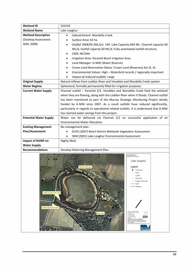
68
Wetland ID 524142
Wetland Name Lake Leaghur
Wetland Description (Desktop Assessment. SKM, 2008)
• Subcatchment: Wandella Creek
• Surface Area: 63 ha
• Outfall 2004/05 (ML/yr): 149. Lake Capacity 664 ML. Channel capacity 60 ML/d, Outfall capacity 60 ML/d. Fully automated outfall structure.
• CMA: NCCMA
• Irrigation Area: Pyramid Boort Irrigation Area
• Land Manager: G‐MW (Water Reserve)
• Crown Land Reservation Status: Crown Land (Reserves) Act (S. 4)
• Environmental Values: High – Waterbird records / regionally important
• Impact of reduced outfalls: Large
Original Supply Natural inflows from Loddon River and Venables and Wandella Creek system.
Water Regime Ephemeral, formally permanently filled for irrigation purposes.
Current Water Supply Channel outfall – Pyramid 2/2. Venables and Wandella Creek feed the wetland when they are flowing, along with the Loddon River when it floods. Channel outfall has been monitored as part of the Murray Strategic Monitoring Project wholly funded by G‐MW since 2007. As a result outfalls have reduced significantly, particularly in regards to operational related outfalls. It is understood that G‐MW has claimed water savings from this project.
Potential Water Supply Water can be delivered via Channel 2/2 on successful application of an Environmental Water Allocation.
Existing Management Plan/Assessment
No management plan ‐
• ECOS (2007) Boort District Wetlands Vegetation Assessment
• SKM (2001) Lake Leaghur Environmental Assessment
Impact of NVIRP on Water Supply
Highly likely
Recommendations Develop Watering Management Plan.

69
Wetland ID 533258
Wetland Name Lake Meran
Wetland Description (Desktop Assessment. SKM, 2008)
• Subcatchment: Wandella Creek
• Surface Area: 175 ha
• Outfall 2004/05 (ML/yr): 123. Lake capacity 9,400 ML. Channel capacity 1000 ML/d, Outfall capacity 80 – 100 ML/d.
• CMA: NCCMA
• Irrigation Area: Pyramid Boort Irrigation Area
• Land Manager: Parks Victoria (Lake Reserve)
• Crown Land Reservation Status: Crown Land (Reserves) Act (S. 4)
• Environmental Values: High – Waterbird records / regionally important
• Impact of reduced outfalls: Medium
Original Supply Wandella Creek (Loddon System) and flood waters that have transversed the Leaghur State Forest. Pickles Canal carries floodwater from Wandella Creek and Leaghur State Forest to the Lake’s natural inlet.
Water Regime Permanent Open Freshwater – Usually more than 1 m deep. Usually retains water for longer than 12 months, however there can be periods of drying.
Current Water Supply Fully automated channel on Boort Channel 8/2 (ST 23656) via the deliver channel also called Pickles Canal. It is still connected to the floodplain. Outfall has been monitored as part of the G‐MW Murray Strategic Monitoring Project, and as a result outfall has reduced significantly particularly operational outfalls. It is understood that G‐MW has claimed savings as a result.
Potential Water Supply Water can be delivered via Channel 8/2 on successful application of an Environmental Water Allocation.
Existing Management Plan/Assessment
• ECOS (2006) Meran Lakes Complex Environmental Values Assessment.
• GHD (2006) DRAFT Meran Lakes Complex Water Operational Plan – Surface Water Management Investigation
Impact of NVIRP on Water Supply
Highly likely
Recommendations Develop Watering Management Plan.

70
Wetland ID 541289
Wetland Name Little Lake Meran
Wetland Description (Desktop Assessment. SKM, 2008)
• Subcatchment: Wandella Creek
• Surface Area: 27 ha
• Outfall 2004/05 (ML/yr): 0. Lake capacity 1500ML. Channel capacity 20 ML/d. Outfall capacity 20 ML/d.
• CMA: NCCMA
• Irrigation Area: Pyramid Boort Irrigation Area
• Land Manager: Parks Victoria (Wildlife Reserve)
• Crown Land Reservation Status: Crown Land (Reserves) Act (S. 4)
• Environmental Values: High – Waterbird records/regionally important
• Impact of reduced outfalls: Large
Original Supply Floodwater from Lake Meran and Wandella Creek (Loddon System). The construction of a levee system in 1934 has isolated the wetland from the floodplain.
Water Regime Permanent Open Freshwater – Usually more than 1 m deep. Usually retains water for longer than 12 months, however there can be periods of drying. Dried out in Jan 2001 for the first time in 80 years.
Current Water Supply No longer part of natural system. Only water received is channel outfall – Boort Channel 4/8/2. The recent reduction in channel outfalls as a result of drought and increased operational efficiency of the irrigation system has significantly reduced outfalls to this wetland.
Potential Water Supply In addition to irrigation supply, Loddon river flood flows can be diverted into the irrigation channel.
Existing Management Plan/Assessment
• ECOS (2006) Meran Lakes Complex Environmental Values Assessment.
• GHD (2006) DRAFT Meran Lakes Complex Water Operational Plan – Surface Water Management Investigation
Impact of NVIRP on Water Supply
Highly likely
Recommendations Develop Watering Management Plan.
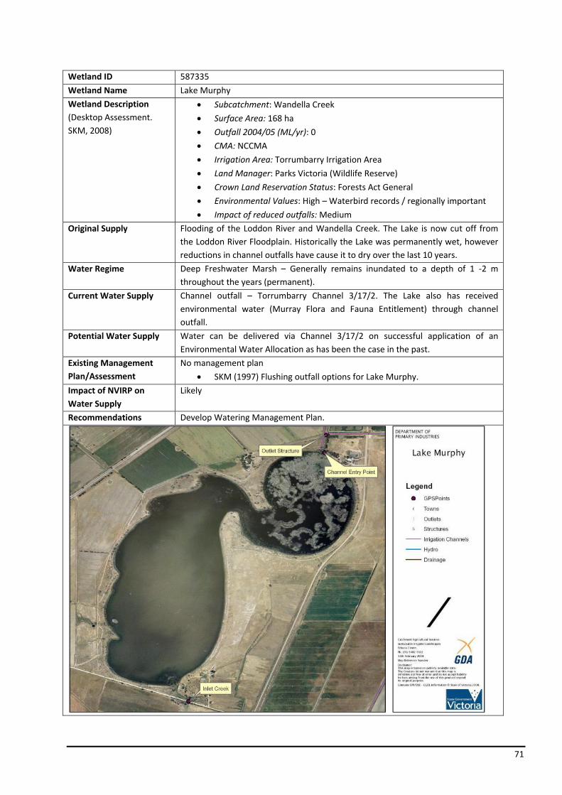
71
Wetland ID 587335
Wetland Name Lake Murphy
Wetland Description (Desktop Assessment. SKM, 2008)
• Subcatchment: Wandella Creek
• Surface Area: 168 ha
• Outfall 2004/05 (ML/yr): 0
• CMA: NCCMA
• Irrigation Area: Torrumbarry Irrigation Area
• Land Manager: Parks Victoria (Wildlife Reserve)
• Crown Land Reservation Status: Forests Act General
• Environmental Values: High – Waterbird records / regionally important
• Impact of reduced outfalls: Medium
Original Supply Flooding of the Loddon River and Wandella Creek. The Lake is now cut off from the Loddon River Floodplain. Historically the Lake was permanently wet, however reductions in channel outfalls have cause it to dry over the last 10 years.
Water Regime Deep Freshwater Marsh – Generally remains inundated to a depth of 1 ‐2 m throughout the years (permanent).
Current Water Supply Channel outfall – Torrumbarry Channel 3/17/2. The Lake also has received environmental water (Murray Flora and Fauna Entitlement) through channel outfall.
Potential Water Supply Water can be delivered via Channel 3/17/2 on successful application of an Environmental Water Allocation as has been the case in the past.
Existing Management Plan/Assessment
No management plan
• SKM (1997) Flushing outfall options for Lake Murphy.
Impact of NVIRP on Water Supply
Likely
Recommendations Develop Watering Management Plan.
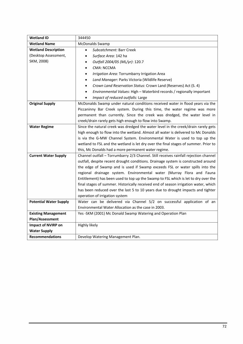
72
Wetland ID 344450
Wetland Name McDonalds Swamp
Wetland Description (Desktop Assessment, SKM, 2008)
• Subcatchment: Barr Creek
• Surface Area: 142 ha
• Outfall 2004/05 (ML/yr): 120.7
• CMA: NCCMA
• Irrigation Area: Torrumbarry Irrigation Area
• Land Manager: Parks Victoria (Wildlife Reserve)
• Crown Land Reservation Status: Crown Land (Reserves) Act (S. 4)
• Environmental Values: High – Waterbird records / regionally important
• Impact of reduced outfalls: Large
Original Supply McDonalds Swamp under natural conditions received water in flood years via the Piccaninny Bar Creek system. During this time, the water regime was more permanent than currently. Since the creek was dredged, the water level in creek/drain rarely gets high enough to flow into Swamp.
Water Regime Since the natural creek was dredged the water level in the creek/drain rarely gets high enough to flow into the wetland. Almost all water is delivered to Mc Donalds is via the G‐MW Channel System. Environmental Water is used to top up the wetland to FSL and the wetland is let dry over the final stages of summer. Prior to this, Mc Donalds had a more permanent water regime.
Current Water Supply Channel outfall – Torrumbarry 2/3 Channel. Still receives rainfall rejection channel outfall, despite recent drought conditions. Drainage system is constructed around the edge of Swamp and is used if Swamp exceeds FSL or water spills into the regional drainage system. Environmental water (Murray Flora and Fauna Entitlement) has been used to top up the Swamp to FSL which is let to dry over the final stages of summer. Historically received end of season irrigation water, which has been reduced over the last 5 to 10 years due to drought impacts and tighter operation of irrigation system
Potential Water Supply Water can be delivered via Channel 5/2 on successful application of an Environmental Water Allocation as the case in 2003.
Existing Management Plan/Assessment
Yes ‐SKM (2001) Mc Donald Swamp Watering and Operation Plan
Impact of NVIRP on Water Supply
Highly likely
Recommendations Develop Watering Management Plan.
73

74
Wetland ID 372703
Wetland Name Golf Course (Tresco) Lake
Wetland Description (Desktop Assessment, SKM, 2008)
• Subcatchment: Kerang Lakes
• Surface Area: 73 ha
• Outfall 2004/05 (ML/yr): 30.5
• CMA: NCCMA
• Irrigation Area: Torrumbarry Irrigation Area
• Land Manager: G‐MW (Water Boards Reserve)
• Crown Land Reservation Status: Crown Land (Reserves) Act (S. 4)
• Environmental Values: High – Waterbird records/regionally important
• Impact of reduced outfalls: None
Original Supply Flooding of the Piccaninny Barr Creek system, which fills Golf Course Lake which then overflows into Round Lake and then into Long Lake. Dredging of the creek (late 1960’s early 70’s) has prevented the Creek from continuing to fill the Golf Course Lake.
Water Regime Permanent Saline (salinity exceeds 3,000 mg/L throughout the whole year).
Current Water Supply Overflow from Round Lake or tile drainage from Tresco Irrigation District. Either case has not occurred for a number of years and low probability of occurring again. No direct access to the G‐MW channel system other than overflow from filling Round Lake to the north with environmental water and forcing water backwaters through the connecting pipelines. Currently Dry.
Potential Water Supply
Existing Management Plan/Assessment
No ‐
• Improved irrigation practices and reduced water allocations has resulted in no drainage for a number of years.
• Feasibility study into the flushing of Golf Course, Round and Long Lakes has been undertaken.
Impact of NVIRP on Water Supply
Highly unlikely
Recommendations No further action required by NVIRP.
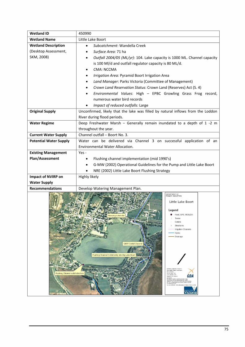
75
Wetland ID 450990
Wetland Name Little Lake Boort
Wetland Description (Desktop Assessment, SKM, 2008)
• Subcatchment: Wandella Creek
• Surface Area: 71 ha
• Outfall 2004/05 (ML/yr): 104. Lake capacity is 1000 ML. Channel capacity is 100 Ml/d and outfall regulator capacity is 80 ML/d.
• CMA: NCCMA
• Irrigation Area: Pyramid Boort Irrigation Area
• Land Manager: Parks Victoria (Committee of Management)
• Crown Land Reservation Status: Crown Land (Reserves) Act (S. 4)
• Environmental Values: High – EPBC Growling Grass Frog record, numerous water bird records
• Impact of reduced outfalls: Large
Original Supply Unconfirmed, likely that the lake was filled by natural inflows from the Loddon River during flood periods.
Water Regime Deep Freshwater Marsh – Generally remain inundated to a depth of 1 ‐2 m throughout the year.
Current Water Supply Channel outfall – Boort No. 3.
Potential Water Supply Water can be delivered via Channel 3 on successful application of an Environmental Water Allocation.
Existing Management Plan/Assessment
Yes ‐
• Flushing channel implementation (mid 1990’s)
• G‐MW (2002) Operational Guidelines for the Pump and Little Lake Boort
• NRE (2002) Little Lake Boort Flushing Strategy
Impact of NVIRP on Water Supply
Highly likely
Recommendations Develop Watering Management Plan.

76
Wetland ID 88586
Wetland Name Little Wallenjoe Swamp
Wetland Description (Desktop Assessment, SKM, 2008)
• Subcatchment: Corop Lakes
• Surface Area: 150 ha
• Outfall 2004/05 (ML/yr): 0 ML
• CMA: GBCMA
• Irrigation Area: Rochester Irrigation Area
• Land Manager: Private
• Crown Land Reservation Status: N/A
• Environmental Values: Very high – DIR
• Impact of reduced outfalls: Large
Original Supply Part of a large series of depressions formed as a result of runoff from the Mt Camel Range. The Swamp is filled by flow from the upstream Wanalta Wetlands System, which are fed from runoff from the southern and eastern ranges.
Water Regime Type 2 – Annually most years in winter spring for 1 – 4 months. Type 3 – Annually most years in winter spring for 4 – 6 months.
Current Water Supply Upstream wetlands in the Wanalta Wetlands System, which are fed from run off from southern and eastern ranges. Water has not to date been delivered to Little Wallenjoe Swamp, as outfalls from the CG 2/14 are provided to and utilised by the adjacent landholder.
Potential Water Supply Potential does exist to direct water (with nominal construction of a small channel from a Detheridge Wheel) to the Swamp from the eastern side via Channel 2/14. A private drain exists immediate to the western flank of the Swamp.
Existing Management Plan/Assessment
Proposed
Impact of NVIRP on Water Supply
Highly unlikely
Recommendations No further action required by NVIRP.
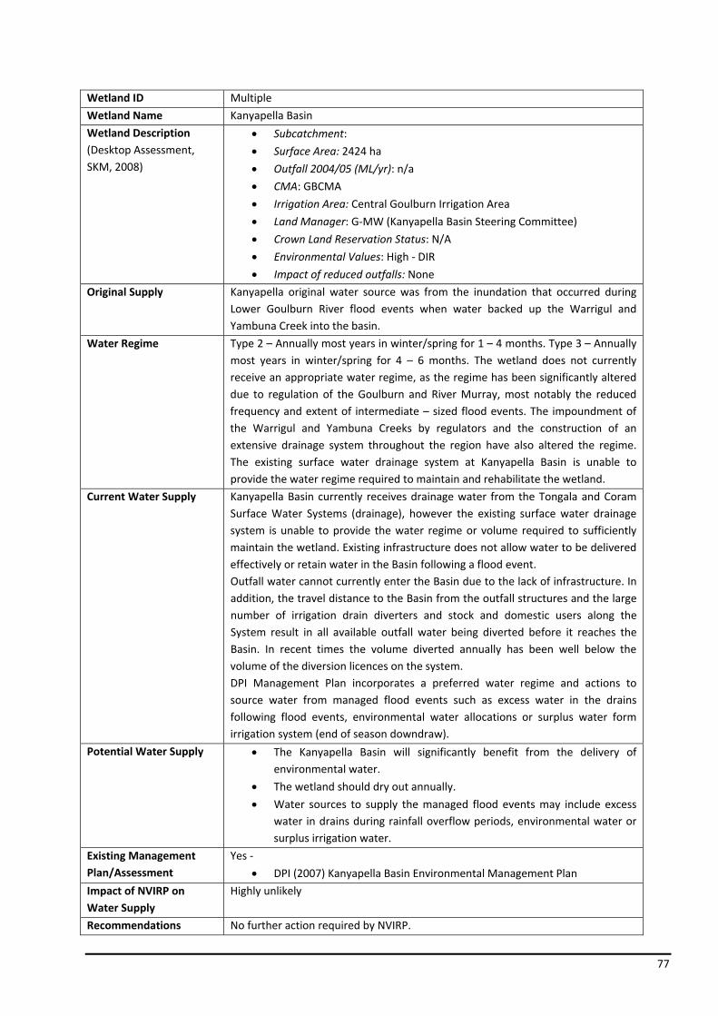
77
Wetland ID Multiple
Wetland Name Kanyapella Basin
Wetland Description (Desktop Assessment, SKM, 2008)
• Subcatchment:
• Surface Area: 2424 ha
• Outfall 2004/05 (ML/yr): n/a
• CMA: GBCMA
• Irrigation Area: Central Goulburn Irrigation Area
• Land Manager: G‐MW (Kanyapella Basin Steering Committee)
• Crown Land Reservation Status: N/A
• Environmental Values: High ‐ DIR
• Impact of reduced outfalls: None
Original Supply Kanyapella original water source was from the inundation that occurred during Lower Goulburn River flood events when water backed up the Warrigul and Yambuna Creek into the basin.
Water Regime Type 2 – Annually most years in winter/spring for 1 – 4 months. Type 3 – Annually most years in winter/spring for 4 – 6 months. The wetland does not currently receive an appropriate water regime, as the regime has been significantly altered due to regulation of the Goulburn and River Murray, most notably the reduced frequency and extent of intermediate – sized flood events. The impoundment of the Warrigul and Yambuna Creeks by regulators and the construction of an extensive drainage system throughout the region have also altered the regime. The existing surface water drainage system at Kanyapella Basin is unable to provide the water regime required to maintain and rehabilitate the wetland.
Current Water Supply Kanyapella Basin currently receives drainage water from the Tongala and Coram Surface Water Systems (drainage), however the existing surface water drainage system is unable to provide the water regime or volume required to sufficiently maintain the wetland. Existing infrastructure does not allow water to be delivered effectively or retain water in the Basin following a flood event. Outfall water cannot currently enter the Basin due to the lack of infrastructure. In addition, the travel distance to the Basin from the outfall structures and the large number of irrigation drain diverters and stock and domestic users along the System result in all available outfall water being diverted before it reaches the Basin. In recent times the volume diverted annually has been well below the volume of the diversion licences on the system. DPI Management Plan incorporates a preferred water regime and actions to source water from managed flood events such as excess water in the drains following flood events, environmental water allocations or surplus water form irrigation system (end of season downdraw).
Potential Water Supply • The Kanyapella Basin will significantly benefit from the delivery of environmental water.
• The wetland should dry out annually.
• Water sources to supply the managed flood events may include excess water in drains during rainfall overflow periods, environmental water or surplus irrigation water.
Existing Management Plan/Assessment
Yes ‐
• DPI (2007) Kanyapella Basin Environmental Management Plan
Impact of NVIRP on Water Supply
Highly unlikely
Recommendations No further action required by NVIRP.
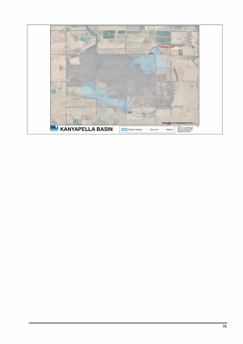
78

79
Wetland ID 619057
Wetland Name Kinnairds Swamp
Wetland Description (DESKTOP ASSESSMENT. SKM, 2008)
• Subcatchment: Muckatah subcatchment
• Surface Area: 100 ha
• Outfall 2004/05 (ML/yr): 155
• CMA: GBCMA
• Irrigation Area: Murray Valley Irrigation Area
• Land Manager: G‐MW
• Crown Land Reservation Status: Crown Land / Private
• Environmental Values: High
• Impact of reduced outfalls: None
Original Supply Kinnairds Swamp is a naturally formed terminal wetland at the bottom of the Muckatah Catchment. Water from Broken Creek during flood also enter the wetland.
Water Regime Shallow Freshwater Marsh – Usually dry by mid‐summer and fill again with the onset of winter rains. Soils are waterlogged throughout the year and surface water up to 0.5 m deep may be present for as long as eight months.
Current Water Supply In the late 1990’s, the Swamp was disconnected from the channel system and became a retardation basin as part of the Muckatah Primary Surface Water Scheme (G‐MW). Stage 1A of the Muckatah Drain was designed to provide 225 ML/d service to the upper catchment whilst only outfalling 150 ML/d to Broken Creek. This is achieved by the drain outfall being restricted to 150 ML/d forcing water to back out of the drain into Kinnairds wetland up to the level of the confining bank. Water then slowly re‐enters the drain via a standard farm drain inlet (FDI) in the south east corner of the wetland when drain flow reduces below 150 ML/d. The MV 5/3 is utilised to pass environmental water to the Swamp.
Potential Water Supply Kinnairds Wetland Environmental Management Plan indicated that if required, the Swamp can be provided with environmental water sourced from nearby irrigation supply channels that exist to the west and east of the wetland. However, delivery would require the construction of a small channel to the wetland from the channel system. Environmental water has been supplied via the outfall at the end of Murray Valley Channel 5/3. This is the only outfall that has capacity to outfall directly to the Muckatah Main Drain and then into the Kinnairds Wetland. The MV 5/3 outfalls is on a spur channel and would likely need to be replaced by a new outfall of adequate capacity on the MV 4 Channel to provide EWA water, if the 5/3 channel is rationalised as part of NVIRP connections program.
Existing Management Plan/Assessment
Yes ‐
• DPI (2003) Kinnairds Swamp Environmental Management Plan
Impact of NVIRP on Water Supply
Highly unlikely
Recommendations No further action required by NVIRP.

80
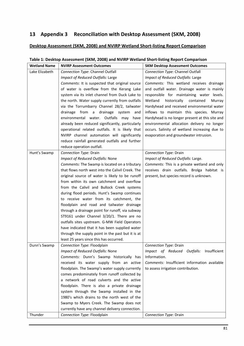
81
13 Appendix 3 Reconciliation with Desktop Assessment (SKM, 2008)
Desktop Assessment (SKM, 2008) and NVIRP Wetland Short‐listing Report Comparison
Table 1: Desktop Assessment (SKM, 2008) and NVIRP Wetland Short‐listing Report Comparison Wetland Name NVIRP Assessment Outcomes SKM Desktop Assessment Outcomes
Lake Elizabeth Connection Type: Channel OutfallImpact of Reduced Outfalls: Large Comments: It is suspected that original source of water is overflow from the Kerang Lake system via its inlet channel from Duck Lake to the north. Water supply currently from outfalls via the Torrumbarry Channel 28/2, tailwater drainage from a drainage system and environmental water. Outfalls may have already been reduced significantly, particularly operational related outfalls. It is likely that NVIRP channel automation will significantly reduce rainfall generated outfalls and further reduce operation outfall.
Connection Type: Channel Outfall Impact of Reduced Outfalls: Large Comments: This wetland receives drainage and outfall water. Drainage water is mainly responsible for maintaining water levels. Wetland historically contained Murray Hardyhead and received environmental water inflows to maintain this species. Murray Hardyhead is no longer present at this site and environmental allocation delivery no longer occurs. Salinity of wetland increasing due to evaporation and groundwater intrusion.
Hunt’s Swamp Connection Type: Drain Impact of Reduced Outfalls: None Comments: The Swamp is located on a tributary that flows north west into the Calivil Creek. The original source of water is likely to be runoff from within its own catchment and overflow from the Calivil and Bullock Creek systems during flood periods. Hunt’s Swamp continues to receive water from its catchment, the floodplain and road and tailwater drainage through a drainage point for runoff, via subway ST9161 under Channel 3/20/1. There are no outfalls sites upstream. G‐MW Field Operators have indicated that it has been supplied water through the supply point in the past but it is at least 25 years since this has occurred.
Connection Type: Drain Impact of Reduced Outfalls: Large. Comments: This is a private wetland and only receives drain outfalls. Brolga habitat is present, but species record is unknown.
Dunn’s Swamp Connection Type: FloodplainImpact of Reduced Outfalls: None Comments: Dunn’s Swamp historically has received its water supply from an active floodplain. The Swamp’s water supply currently comes predominately from runoff collected by a network of road culverts and the active floodplain. There is also a private drainage system through the Swamp installed in the 1980's which drains to the north west of the Swamp to Myers Creek. The Swamp does not currently have any channel delivery connection.
Connection Type: Drain Impact of Reduced Outfalls: Insufficient Information. Comments: Insufficient information available to assess irrigation contribution.
Thunder Connection Type: Floodplain Connection Type: Drain
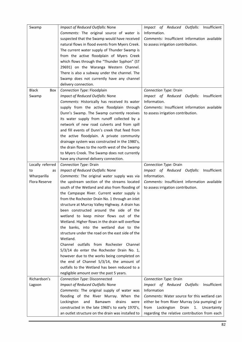
82
Swamp Impact of Reduced Outfalls: NoneComments: The original source of water is suspected that the Swamp would have received natural flows in flood events from Myers Creek. The current water supply of Thunder Swamp is from the active floodplain of Myers Creek which flows through the “Thunder Syphon” (ST 29691) on the Waranga Western Channel. There is also a subway under the channel. The Swamp does not currently have any channel delivery connection.
Impact of Reduced Outfalls: Insufficient Information. Comments: Insufficient information available to assess irrigation contribution.
Black Box Swamp
Connection Type: FloodplainImpact of Reduced Outfalls: None Comments: Historically has received its water supply from the active floodplain through Dunn’s Swamp. The Swamp currently receives its water supply from runoff collected by a network of new road culverts and from spill and fill events of Dunn’s creek that feed from the active floodplain. A private community drainage system was constructed in the 1980’s, the drain flows to the north west of the Swamp to Myers Creek. The Swamp does not currently have any channel delivery connection.
Connection Type: Drain Impact of Reduced Outfalls: Insufficient Information. Comments: Insufficient information available to assess irrigation contribution.
Locally referred to as Wharparilla Flora Reserve
Connection Type: Drain Impact of Reduced Outfalls: None Comments: The original water supply was via the upstream section of the streams located south of the Wetland and also from flooding of the Campaspe River. Current water supply is from the Rochester Drain No. 1 through an inlet structure at Murray Valley Highway. A drain has been constructed around the side of the wetland to keep minor flows out of the Wetland. Higher flows in the drain will overflow the banks, into the wetland due to the structure under the road on the east side of the Wetland. Channel outfalls from Rochester Channel 5/3/14 do enter the Rochester Drain No. 1, however due to the works being completed on the end of Channel 5/3/14, the amount of outfalls to the Wetland has been reduced to a negligible amount over the past 5 years.
Connection Type: Drain Impact of Reduced Outfalls: Insufficient Information. Comments: Insufficient information available to assess irrigation contribution.
Richardson’s Lagoon
Connection Type: DisconnectedImpact of Reduced Outfalls: None Comments: The original supply of water was flooding of the River Murray. When the Lockington and Bamawm drains were constructed in the late 1960’s to early 1970’s, an outlet structure on the drain was installed to
Connection Type: Drain Impact of Reduced Outfalls: Insufficient Information Comments: Water source for this wetland can either be from River Murray (via pumping) or from Lockington Drain 1. Uncertainty regarding the relative contribution from each

83
divert water into the Lagoon. In 1992, a fixed crest weir, inlet/outlet structures and bypass drain was installed to allow better management of the water entering the Lagoon. The Lagoon currently receives water directly from the River Murray or from Lockington Drain 1. Works have been completed to stop any irrigation induced flows from drains entering the wetland.
source (e.g. operating rules for pumps) and therefore potential impact of reduced channel outfalls is unknown.
Murphy’s Swamp
Connection Type: Drain Impact of Reduced Outfalls: None Comments: The water supply originally was runoff from the Bamawm Depression to the south, along with water from the flooding of the River Murray. Any water received by Murphy’s Swamp is via PSWMS. The water supply comes from drainage (due to irrigation tailwater) in the irrigation season and rainfall runoff in winter/spring. Works in the Drain, include a weir and a number of overflow sills (not formalised; only cuts in drain banks). Management plan recommends Swamp dry out from December to May.
Connection Type: Drain Impact of Reduced Outfalls: Medium. Comments: Receives channel outfalls via drainage network. Small local drainage catchment with no floodwater. Removal of channel outfalls would substantially dry it.
Johnson Swamp Connection Type: Channel OutfallImpact of Reduced Outfalls: Large Comments: The original source of water was from the Pyramid Creek. It is believed that originally Pyramid Creek flowed through the Swamp, intermittently flooding the Swamp. With the advent of irrigation in the 1920’s, the swamp became permanently inundated. The dredging of Pyramid Creek in 1967 resulted in the Swamp being removed from its natural water supply. Water currently received by the Swamp is predominantly supplied through the outfall structure on the Torrumbarry Channel 4/7/2 and from local runoff including tailwater drainage. In 1987, Johnson Swamp was provided with environmental water. It is considered that the NVIRP channel automation may have some impact on rainfall generated outfalls.
Connection Type: Channel Outfall and On –Line Impact of Reduced Outfalls: Large. Comments: Main source of water for swamp is environmental allocation that is delivered via irrigation channels. Reductions in channel outfalls expected to have a large effect on water regime.
Round Lake (nr Boga)
Connection Type: Channel OutfallImpact of Reduced Outfalls: Large Comments: Under natural conditions Round Lake received overflow from Tresco (Golf Course) Lake. The Lake receives water from the outfall structure on the Torrumbarry Channel 1/9. Since 2002/03, it is confirmed that only environmental water has been provided through the channel structure.
Connection Type: Channel Outfall Impact of Reduced Outfalls: Large Comments: Due the wetland being small in size, any water reductions will have a significant impact. Some drying of the wetland has already occurred through drought impacts and irrigation system improvements. Wetland is one of only three wetlands in northern Victoria with the EPBC listed Murray
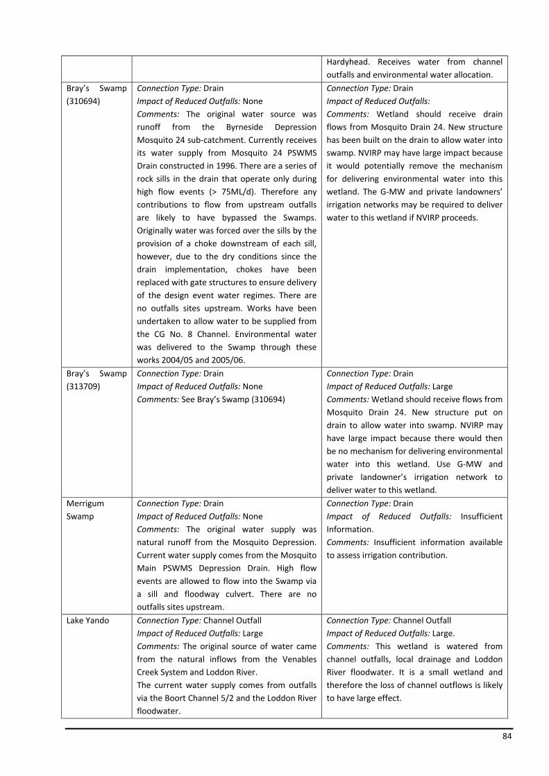
84
Hardyhead. Receives water from channel outfalls and environmental water allocation.
Bray’s Swamp (310694)
Connection Type: Drain Impact of Reduced Outfalls: None Comments: The original water source was runoff from the Byrneside Depression Mosquito 24 sub‐catchment. Currently receives its water supply from Mosquito 24 PSWMS Drain constructed in 1996. There are a series of rock sills in the drain that operate only during high flow events (> 75ML/d). Therefore any contributions to flow from upstream outfalls are likely to have bypassed the Swamps. Originally water was forced over the sills by the provision of a choke downstream of each sill, however, due to the dry conditions since the drain implementation, chokes have been replaced with gate structures to ensure delivery of the design event water regimes. There are no outfalls sites upstream. Works have been undertaken to allow water to be supplied from the CG No. 8 Channel. Environmental water was delivered to the Swamp through these works 2004/05 and 2005/06.
Connection Type: Drain Impact of Reduced Outfalls: Comments: Wetland should receive drain flows from Mosquito Drain 24. New structure has been built on the drain to allow water into swamp. NVIRP may have large impact because it would potentially remove the mechanism for delivering environmental water into this wetland. The G‐MW and private landowners’ irrigation networks may be required to deliver water to this wetland if NVIRP proceeds.
Bray’s Swamp (313709)
Connection Type: Drain Impact of Reduced Outfalls: None Comments: See Bray’s Swamp (310694)
Connection Type: Drain Impact of Reduced Outfalls: Large Comments: Wetland should receive flows from Mosquito Drain 24. New structure put on drain to allow water into swamp. NVIRP may have large impact because there would then be no mechanism for delivering environmental water into this wetland. Use G‐MW and private landowner’s irrigation network to deliver water to this wetland.
Merrigum Swamp
Connection Type: Drain Impact of Reduced Outfalls: None Comments: The original water supply was natural runoff from the Mosquito Depression. Current water supply comes from the Mosquito Main PSWMS Depression Drain. High flow events are allowed to flow into the Swamp via a sill and floodway culvert. There are no outfalls sites upstream.
Connection Type: Drain Impact of Reduced Outfalls: Insufficient Information. Comments: Insufficient information available to assess irrigation contribution.
Lake Yando Connection Type: Channel OutfallImpact of Reduced Outfalls: Large Comments: The original source of water came from the natural inflows from the Venables Creek System and Loddon River. The current water supply comes from outfalls via the Boort Channel 5/2 and the Loddon River floodwater.
Connection Type: Channel Outfall Impact of Reduced Outfalls: Large. Comments: This wetland is watered from channel outfalls, local drainage and Loddon River floodwater. It is a small wetland and therefore the loss of channel outflows is likely to have large effect.

85
Works are currently being undertaken to increase the outfall channel and structures capacity.
Lake Leaghur Connection Type: Channel OutfallsImpact of Reduced Outfalls: Large Comments: The Lakes original source of water is from natural inflows from Loddon River and both the Venables and Wandella Creek systems. Water now currently comes from channel outfalls via the Boort Channel 2/2. Venables and Wandella Creek also continue to feed the Lake when they are flowing and Loddon River when it floods. The channel outfall has been monitored as part of the Murray Strategic Monitoring Project since 2007. As a result outfalls may have already reduced significantly particularly in regard to operational related outfalls, prior to the implementation of the NVIRP. It is considered that the NVIRP channel automation is likely to significantly reduce rainfall generated outfalls and further reduce operation outfalls.
Connection Type: Channel Outfall Impact of Reduced Outfalls: Large. Comments: This wetland is mainly watered by channel outfalls. It gets some water from the Loddon River when it floods, but this is rare. The recent reduction in channel outfalls as a result of drought and increased operational efficiency of the irrigation system has significantly reduced channel outfalls to this wetland. Is currently dry.
Lake Meran Connection Type: Channel OutfallImpact of Reduced Outfalls: Medium Comments: The original water supply came from Wandella Creek in the Loddon System and flood waters that transversed the Leaghur State Forest. Pickles Canal carries floodwater from Wandella Creek and the Leaghur State Forest to the Lake’s natural inlet. The Lake’s current water supply comes from fully automated channel outfall on Boort Channel 8/2 (ST 23656) via the deliver channel also called Pickles Canal. The Lake is still connected to an active floodplain. The channel outfall has been monitored as part of the Murray Strategic Monitoring Project. As a result outfalls may have already reduced significantly, particularly in regard to operational related outfalls, prior to the implementation of the NVIRP. It is considered likely that the NVIRP channel automation will significantly reduce rainfall generated outfalls and further reduce operation outfall.
Connection Type: Channel Outfall Impact of Reduced Outfalls: Medium to Large. Comments: Historically significant amounts of irrigation water discharged into this wetland. The recent reduction in channel outfalls as a result of drought and increased operational efficiency of the irrigation system has significantly reduced channel outfalls to this wetland. Is currently dry.
Little Lake Meran
Connection Type: Channel OutfallImpact of Reduced Outfalls: Large Comments: The original water supply was floodwater from Lake Meran and Wandella Creek in the Loddon System. The construction of a levee system in 1934 has isolated the
Connection Type: Channel Outfall Impact of Reduced Outfalls: Large. Comments: This wetland has been artificially isolated from floodwaters. It has a small local catchment and therefore channel outfalls represent a large proportion of the water that
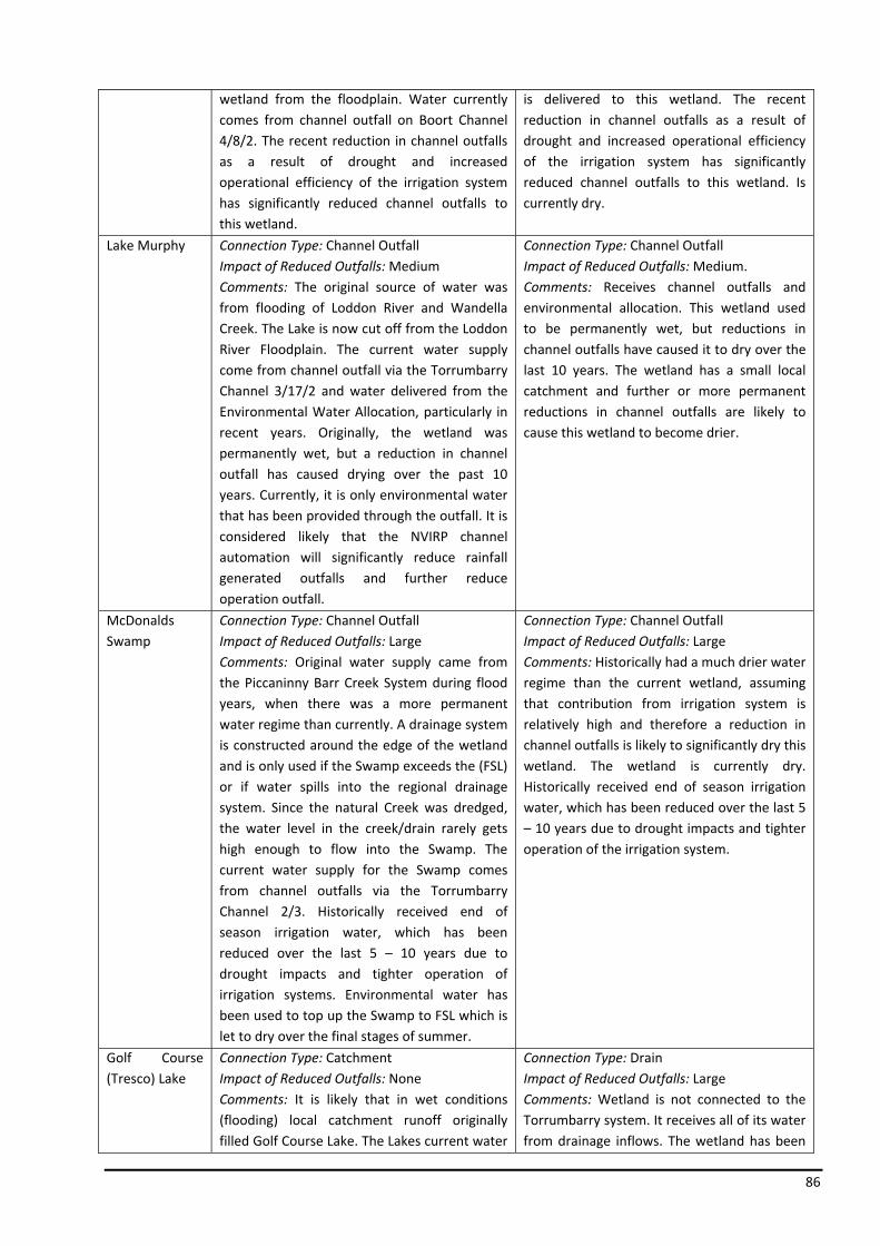
86
wetland from the floodplain. Water currently comes from channel outfall on Boort Channel 4/8/2. The recent reduction in channel outfalls as a result of drought and increased operational efficiency of the irrigation system has significantly reduced channel outfalls to this wetland.
is delivered to this wetland. The recent reduction in channel outfalls as a result of drought and increased operational efficiency of the irrigation system has significantly reduced channel outfalls to this wetland. Is currently dry.
Lake Murphy Connection Type: Channel OutfallImpact of Reduced Outfalls: Medium Comments: The original source of water was from flooding of Loddon River and Wandella Creek. The Lake is now cut off from the Loddon River Floodplain. The current water supply come from channel outfall via the Torrumbarry Channel 3/17/2 and water delivered from the Environmental Water Allocation, particularly in recent years. Originally, the wetland was permanently wet, but a reduction in channel outfall has caused drying over the past 10 years. Currently, it is only environmental water that has been provided through the outfall. It is considered likely that the NVIRP channel automation will significantly reduce rainfall generated outfalls and further reduce operation outfall.
Connection Type: Channel Outfall Impact of Reduced Outfalls: Medium. Comments: Receives channel outfalls and environmental allocation. This wetland used to be permanently wet, but reductions in channel outfalls have caused it to dry over the last 10 years. The wetland has a small local catchment and further or more permanent reductions in channel outfalls are likely to cause this wetland to become drier.
McDonalds Swamp
Connection Type: Channel OutfallImpact of Reduced Outfalls: Large Comments: Original water supply came from the Piccaninny Barr Creek System during flood years, when there was a more permanent water regime than currently. A drainage system is constructed around the edge of the wetland and is only used if the Swamp exceeds the (FSL) or if water spills into the regional drainage system. Since the natural Creek was dredged, the water level in the creek/drain rarely gets high enough to flow into the Swamp. The current water supply for the Swamp comes from channel outfalls via the Torrumbarry Channel 2/3. Historically received end of season irrigation water, which has been reduced over the last 5 – 10 years due to drought impacts and tighter operation of irrigation systems. Environmental water has been used to top up the Swamp to FSL which is let to dry over the final stages of summer.
Connection Type: Channel Outfall Impact of Reduced Outfalls: Large Comments: Historically had a much drier water regime than the current wetland, assuming that contribution from irrigation system is relatively high and therefore a reduction in channel outfalls is likely to significantly dry this wetland. The wetland is currently dry. Historically received end of season irrigation water, which has been reduced over the last 5 – 10 years due to drought impacts and tighter operation of the irrigation system.
Golf Course (Tresco) Lake
Connection Type: CatchmentImpact of Reduced Outfalls: None Comments: It is likely that in wet conditions (flooding) local catchment runoff originally filled Golf Course Lake. The Lakes current water
Connection Type: Drain Impact of Reduced Outfalls: Large Comments: Wetland is not connected to the Torrumbarry system. It receives all of its water from drainage inflows. The wetland has been
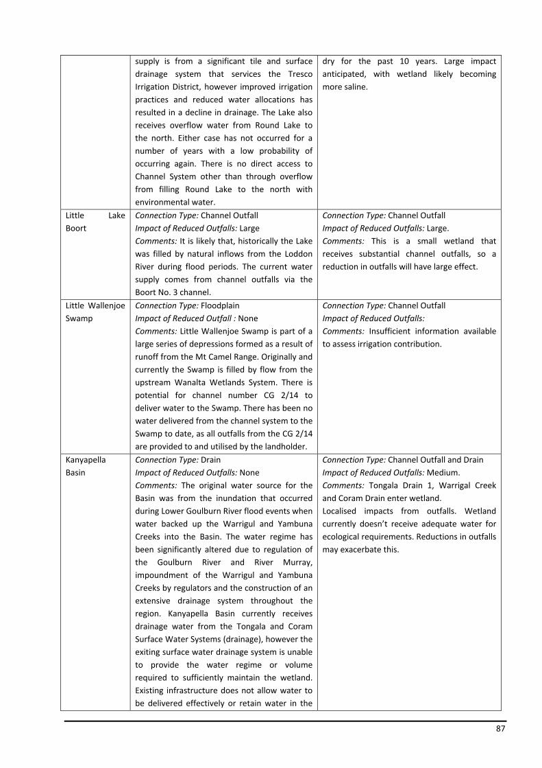
87
supply is from a significant tile and surface drainage system that services the Tresco Irrigation District, however improved irrigation practices and reduced water allocations has resulted in a decline in drainage. The Lake also receives overflow water from Round Lake to the north. Either case has not occurred for a number of years with a low probability of occurring again. There is no direct access to Channel System other than through overflow from filling Round Lake to the north with environmental water.
dry for the past 10 years. Large impact anticipated, with wetland likely becoming more saline.
Little Lake Boort
Connection Type: Channel OutfallImpact of Reduced Outfalls: Large Comments: It is likely that, historically the Lake was filled by natural inflows from the Loddon River during flood periods. The current water supply comes from channel outfalls via the Boort No. 3 channel.
Connection Type: Channel Outfall Impact of Reduced Outfalls: Large. Comments: This is a small wetland that receives substantial channel outfalls, so a reduction in outfalls will have large effect.
Little Wallenjoe Swamp
Connection Type: FloodplainImpact of Reduced Outfall : None Comments: Little Wallenjoe Swamp is part of a large series of depressions formed as a result of runoff from the Mt Camel Range. Originally and currently the Swamp is filled by flow from the upstream Wanalta Wetlands System. There is potential for channel number CG 2/14 to deliver water to the Swamp. There has been no water delivered from the channel system to the Swamp to date, as all outfalls from the CG 2/14 are provided to and utilised by the landholder.
Connection Type: Channel Outfall Impact of Reduced Outfalls: Comments: Insufficient information available to assess irrigation contribution.
Kanyapella Basin
Connection Type: Drain Impact of Reduced Outfalls: None Comments: The original water source for the Basin was from the inundation that occurred during Lower Goulburn River flood events when water backed up the Warrigul and Yambuna Creeks into the Basin. The water regime has been significantly altered due to regulation of the Goulburn River and River Murray, impoundment of the Warrigul and Yambuna Creeks by regulators and the construction of an extensive drainage system throughout the region. Kanyapella Basin currently receives drainage water from the Tongala and Coram Surface Water Systems (drainage), however the exiting surface water drainage system is unable to provide the water regime or volume required to sufficiently maintain the wetland. Existing infrastructure does not allow water to be delivered effectively or retain water in the
Connection Type: Channel Outfall and DrainImpact of Reduced Outfalls: Medium. Comments: Tongala Drain 1, Warrigal Creek and Coram Drain enter wetland. Localised impacts from outfalls. Wetland currently doesn’t receive adequate water for ecological requirements. Reductions in outfalls may exacerbate this.
88
Basin following a flood event.Outfall water can’t currently enter the Basin due to the lack of infrastructure. In addition, the travel distance to the Basin from the outfall structures and the large number of irrigation drain diverters and stock and domestic users along the System result in all available outfall water being divert before it reaches the Basin.
Kinnairds Wetland
Connection Type: Drain Impact of Reduced Outfalls: None Comments: Wetland included in the assessment having recently being identified as having high environmental values after the discovery of a nationally threatened species, Ridged Water‐Milfoil. The wetland has had a history of increased and prolonged flooding since the introduction of irrigated agriculture to the district. The Swamp currently receives water from the Muckatah Surface Water Management Scheme. The surface water management works have been designed to utilise the wetland as a retardation basin and filtering system whilst enhancing the wetland values, reinstating natural flood regimes. Higher than design flows will continue to flow and spread throughout the Swamp, similar to natural conditions by overtopping the confining banks. The Swamp has benefited form delivery of environmental water in recent times.
Connection Type: Drain Impact of Reduced Outfalls: N/A Comments: Kinnairds Swamp was included in the 78 wetlands that were identified in the Desktop Assessment (SKM, 2008) as directly connected to the irrigation channel outlet or drain, however at the time of the Desktop Assessment (SKM, 2008) Kinnairds Swamp was not deemed to have high enough environmental values to be included as one of the 23 short‐listed wetlands and as such was not fully assessed.
Individual Site Comparison
Lake Elizabeth
The NVIRP assessment results are consistent with that of the Desktop Assessment (SKM, 2008). Additional information, particularly in regards to the original and current water supply was sourced from the Macumber (2007) “Lake Elizabeth Operational Plan and Management Options” , which was carried out by Phillip Consulting Services for the DPI and from the NVIRP ground truthing exercise results. Consultation with G‐MW, DPI and DSE staff was also carried out to obtain additional information to further determine the impact of NVIRP and therefore the correct management of the Lake.
Hunt’s Swamp
The NVIRP assessment results are consistent with that of the Desktop Assessment (SKM, 2008), however information in the Desktop Assessment relevant to Hunt’s Swamp was minimal. Additional information required to make a more informed decision on the management of the Swamp was sourced mainly from the results of the NVIRP ground truthing exercise. Consultation with G‐MW staff was also carried out for this Swamp.
Dunn’s Swamp
89
The Desktop Assessment (SKM, 2008) contained minimal information on Dunn’s Swamp, stating that there is “insufficient information available to access irrigation contribution”. Information used to assess the impact of the NVIRP and determine the management of the Swamp was sourced from the NVIRP ground truthing exercise results.
Thunder Swamp
The Desktop Assessment (SKM, 2008) contained minimal information on Thunder Swamp, stating that there is “insufficient information available to access irrigation contribution”. To determine the impact of the NVIRP and management required, information was obtained from the NVIRP ground truthing exercise results.
Black Box Swamp
The Desktop Assessment (SKM, 2008) contained minimal information on Black Box Swamp, stating that there is “insufficient information available to access irrigation contribution”. Information used to assess the impact of the NVIRP and determine the management of the Swamp was sourced from the NVIRP ground truthing exercise results.
Wharparilla Flora Reserve
The Desktop Assessment (SKM, 2008) contained minimal information on the Wharparilla Flora Reserve, stating that there is “insufficient information available to access irrigation contribution”. To determine the impact of the NVIRP and therefore the management of the Swamp, information was obtained from the NVIRP ground truthing exercise results.
Richardson’s Lagoon (East)
The NVIRP assessment results are consistent with that of the Desktop Assessment (SKM, 2008). Additional information, particularly in regards to the original and current water supply was sourced from the SKM (1999) “Richardsons Lagoon and Murphy’s Swamp Environmental Management Plan”. Information was also taken from the NVIRP ground truthing exercise results to further determine the impact of NVIRP and therefore the correct management of the Lake.
Murphy’s Swamp
The NVIRP assessment results are consistent with that of the Desktop Assessment (SKM, 2008), however information in the Desktop Assessment relevant to Murphy’s Swamp was minimal. Additional information required to make a more informed decision on management of the Swamp was sourced mainly from information collected as part of the NVIRP ground truthing exercise and the SKM (1999) “Richardsons Lagoon and Murphy’s Swamp Environmental Management Plan”. Consultation with G‐MW staff in regards to this Swamp was also carried out.
Johnsons Swamp
The NVIRP assessment results for Johnsons Swamp are consistent with that of the Desktop Assessment (SKM, 2008), however information in the Desktop Assessment relevant to Johnsons Swamp was minimal. To determine the impact of the NVIRP and therefore the management of the Swamp, additional information was required and sourced from the DSE (2004) “Kerang Wetlands Ramsar Site – Strategic Management Plan” and the NCCMA (2001) “Wetland Watering and Operational Management Plan for Johnsons Swamp”. Information was also sourced from the NVIRP
90
ground truthing exercise results and consultation with G‐MW, DPI and DSE staff in regards to this Swamp was also carried out.
Round Lake (near Boga)
The NVIRP assessment results are consistent with that of the Desktop Assessment (SKM, 2008). In general, information on Round Lake was found to be minimal, with the only additional information sourced being from the NVIRP ground truthing exercise results and consultation with DSE staff.
Bray’s Swamp 313709 and 310694
The NVIRP assessment results for both Bray’s Swamp sites are consistent with that of the Desktop Assessment (SKM, 2008). Additional information, particularly in regards to original and current water supply was sourced from the DPI (2001) “Bray’s Swamp Wetland Management Plan” and the NVIRP ground truthing exercise results.
Merrigum Swamp
The Desktop Assessment (SKM, 2008) contained minimal information on Merrigum Swamp, stating that there is “insufficient information available to access irrigation contribution”. To determine the impact of the NVIRP and therefore the management of the Swamp, information was obtained from the NVIRP ground truthing exercise results.
Lake Yando
The NVIRP assessment results relating to Lake Yando are consistent with that of the Desktop Assessment (SKM, 2008). In general, information on Lake Yando was found to be minimal. Additional information was sourced from the ECOS “Boort District Wetlands Vegetation Assessment, NVIRP ground truthing exercise results and consultation with G‐MW and DPI staff.
Lake Leaghur
The NVIRP assessment results relating to Lake Leaghur are consistent with that of the Desktop Assessment (SKM, 2008). Additional information, particularly in regards to the original and current water supply was sourced from the ECOS (2006) “Boort District Wetlands Vegetation Assessment” and the NVIRP ground truthing exercise results. Consultation with G‐MW and DPI staff was also carried out to obtain additional information to further determine the impact of NVIRP and therefore the correct management of the Lake.
Lake Meran
The NVIRP assessment results relating to Lake Meran are consistent with that of the Desktop Assessment (SKM, 2008). Additional information was sourced from the ECOS (2006) “Meran Lakes Complex Environmental Values Assessment” and the NVIRP ground truthing exercise results. Consultation with G‐MW and DPI staff was also carried out to obtain additional information to further determine the impact of NVIRP and therefore the correct management of the Lake.
Little Lake Meran
The NVIRP assessment results relating to Little Lake Meran are consistent with that of the Desktop Assessment (SKM, 2008). In general, information on Little Lake Meran was found to be minimal. Additional information was sourced from the ECOS (2006) “Meran Lakes Complex Environmental
91
Values Assessment, the NVIRP ground truthing exercise results and consultation with G‐MW and DPI staff.
Lake Murphy
The NVIRP assessment results relating to Lake Murphy are consistent with that of the Desktop Assessment (SKM, 2008). Additional information was sourced from the NVIRP ground truthing exercise results and consultation with G‐MW and DSE staff to obtain additional information to further determine the impact of NVIRP and therefore the correct management of the Lake.
McDonalds Swamp
The NVIRP assessment results relating to McDonalds Swamp are consistent with that of the Desktop Assessment (SKM, 2008). Additional information, particularly in regards to the original and current water supply was sourced from the NVIRP ground truthing exercise results. Consultation with G‐MW and DSE staff was also carried out to obtain additional information to further determine the impact of NVIRP and therefore the correct management of the Lake.
Golf Course (Tresco) Lake
The NVIRP assessment results relating to Tresco Lake are consistent with that of the Desktop Assessment (SKM, 2008). Additional information, particularly in regards to original and current water supply was sourced from the NVIRP ground truthing exercise results, along with consultation with G‐MW and DSE staff to enable a more informed management decision for the Lake.
Little Lake Boort
The NVIRP assessment results relating to Little Lake Boort are consistent with that of the Desktop Assessment (SKM, 2008). In general, information on Little Lake Boort was found to be minimal. Additional information was sourced from the NVIRP ground truthing exercise results and NRE (2002) “Little Lake Boort Flushing Strategy”. Consultation with G‐MW and DPI staff was also carried out to further determine the impact of the NVIRP and therefore the correct management of the Lake.
Little Wallenjoe Swamp
The Desktop Assessment (SKM, 2008) contained minimal information on Little Wallenjoe Swamp, indicating that there is “insufficient information available to access irrigation contribution”. The Report does state that the Swamp is connected to channel outfall, however from information gathered in the NVIRP ground truthing exercise, the NVIRP Wetland Short‐listing Report has identified the Swamp as having drainage connection.
Kanyapella Basin
The NVIRP assessment results relating to Kanyapella Basin are consistent with that of the Desktop Assessment (SKM, 2008). Additional information, particularly in regards to original and current water supply was sourced from the NVIRP ground truthing exercise results and the DPI (2007) “Kanyapella Basin Environmental Management Plan”.
Kinnairds Swamp
Kinnaird Swamp was not included on the preliminary list of wetlands identified in the Desktop Assessment (SKM, 2008), therefore a comparison cannot be made. Information used in the NVIRP

92
assessment was sourced from the DPI (2003) “Kinnairds Swamp Environmental Management Plan”, with further information obtained through consultation with G‐MW, DSE and DPI staff.

93
14 Appendix 4 NVIRP Program