Embed Size (px)
Citation preview

NORTHERN BEACHES HOSPITAL ROAD CONNECTIVITY AND NETWORK ENHANCEMENT Options Development and Selection Report DECEMBER 2014
RMS 14.560 ISBN: 978-1-925217-14-8

MONTH/YEAR (blank page)

RMS 14.561
ISBN: 978-1-925217-14-8
Prepared by SMEC Australia Pty Ltd
This document has been prepared to provide a general update to the community as to its subject matter. It does not purport to perform any statutory function. No warranty is made as to the accuracy, completeness and currency of the information herein. No reliance should be made on this document in connection with any specific matter or issue in respect of the Stage 1 Connectivity Works, the Stage 2 Network Enhancement Works or the Concept Proposal for those works. Both proposed projects and/or the Concept Proposal may be modified from time to time, including after the date of this report, in accordance with applicable legislation.
Roads and Maritime Services
Northern Beaches Hospital Road Connectivity and Network Enhancement Options Development and Selection Report December 2014


Executive summary This report has been prepared to update the community on the status of the Northern Beaches Hospital Road Connectivity and Network Enhancement Project (Project). The report summarises the overall Project (Concept Proposal) and Stage 1 Connectivity Works which were the subject of a recently publicly exhibited Environmental Impact Statement (EIS) relating to the Concept Proposal and Stage 1 Works. It also provides an update on the options assessment for the Stage 2 Network Enhancement Works which will be the subject of a separate EIS to be placed on public exhibition by mid-2015.
This report does not form part of the planning application and assessment documentation for the Project. That documentation is available from the Department of Planning and Environment's development assessment tracking system1.
Project description
The overall Project comprises the Stage 1 Connectivity Works, being the provision of essential road works to enhance connectivity to the new Northern Beaches Hospital at Frenchs Forest, and the Stage 2 Network Enhancement Works to improve capacity of local roads and the broader network.
Background
The NSW Government is reconfiguring the delivery of health services for the Northern Beaches through the Northern Beaches Health Service Redevelopment Project. The cornerstone is the new hospital at the intersection of Warringah Road and Wakehurst Parkway, which is scheduled to open in 2018.
The road network surrounding the hospital site is highly constrained by topography and is at the confluence of six arterial road routes that carry up to 80,000 vehicles daily. Existing at-grade intersections surrounding the hospital site are currently operating near capacity, particularly the signalised Warringah Road/Wakehurst Parkway and Warringah Road/Forest Way intersections. The proximity of the hospital to these key intersections has significant ramifications for network performance. There are also existing turning restrictions at several intersections that, if retained, would impair efficient access to the hospital.
Strategic context
There are a number of key land use and transport planning strategies that establish the strategic context for the Project both in its own right and in conjunction with the Northern Beaches Hospital. These include NSW 2021: A Plan to Make NSW Number One, the State Infrastructure Strategy, the NSW Long Term Transport Master Plan, and Sydney’s Bus Future.
Project objectives
The strategic aims of the Project include the provision of a road network solution that optimises connectivity of the existing road network surrounding the hospital. At a broader network level, the Project aims to reinforce Warringah Road and Wakehurst Parkway as key
1 http://majorprojects.planning.nsw.gov.au
Northern Beaches Hospital Road Connectivity and Network Enhancement v Options Development and Selection Report

arterial connections between the beachside suburbs of Sydney’s north and Chatswood and Sydney’s CBD.
The specific project objectives are to:
• Improve peak period travel speeds and reliability on Warringah Road following the development of the hospital and the surrounding precinct
• Improve the network performance surrounding the hospital to support the development of the precinct
• Support the activation of the Northern Beaches Hospital Precinct by facilitating access connections to the hospital
• Allow for road-based public transport along and across the corridor
• Maintain or improve road safety in accordance with current standards
• Minimise impacts on the environment
• Optimise the design to provide an urban design and landscape outcome that complements the surrounding environs.
Content of the report
This report:
• Outlines the need for the Project
• Provides and update on the processes which have been carried out to identify options for the Concept Proposal, Stage 1 and Stage 2 projects
• Provides information on the criteria used to assess the Project to ensure the preferred options selected addresses the need for the Project
• Describes the options identified
• Describes and updates the community on the options assessment process and outcomes, particularly in relation to the Stage 2 Project
• Outlines the community and stakeholder engagement carried out, and how feedback has been considered as part of the options development process
• Identifies the preferred option for the Project, and provides justification for its selection and how it meets the evaluation criteria and the project objectives.
Methodology
The general methodology for the development and evaluation of options for the Project comprised:
• Identification of evaluation criteria within the context of the project objectives and broad desired outcomes
• Identification and evaluation of feasible strategic transport solutions
• Development and evaluation of options through a range of mechanisms such as establishment of an industry challenge process, Value Management (VM), and specialist technical reviews
Northern Beaches Hospital Road Connectivity and Network Enhancement vi Options Development and Selection Report

• Stakeholder consultation to identify issues for consideration in option development
• Identification of a preferred option for the Project.
Strategic transport alternatives
The following four strategic transport solutions were considered for the Project:
1. The base case or ‘do nothing/do minimum’
2. Road-based improvement options
3. Investment to improve public transport
4. Demand management.
Of these, the road-based improvements option was identified as the preferred strategic solution that would best meet the project objectives. Subsequently, various options were considered for the Northern Beaches Hospital road network. Option identification began with development of various minor works at primary intersections before progressing into a network-wide solution.
Options considered fell into the following broad groupings of works:
• Option 1 – Base case or ‘do nothing/do minimum’
• Option 2 – Rudimentary hospital connectivity
• Option 3 – Hospital connectivity and minor network enhancements
• Option 4 – Network enhancements through a grade separated underpass (Warringah Road under Wakehurst Parkway, Hilmer Street and Forest Way)
• Option 5 – Network enhancements through a grade separated overpass (Warringah Road over Wakehurst Parkway and Warringah Road under Forest Way).
Initially, it was envisaged that delivery of the Project would occur as a single stage. However, development of the concept design for the hospital connectivity works progressed more quickly than the wider network enhancement concept design. It was decided to separate the project into two stages to allow flexibility in progressing the environmental assessment and application for planning approval.
The Project therefore comprises:
• Stage 1 – Connectivity Works, which aim to enhance the existing road network to facilitate the opening of the proposed Northern Beaches Hospital in 2018 (Option 3)
• Stage 2 – Network Enhancement Works, which are directed towards broader network capacity enhancement, particularly along Warringah Road, and including a grade separated underpass for east-west through traffic (Option 4).
Consultation was carried out from March to April 2014 and from July to August 2014. The aim of the consultation was to inform the community and key stakeholders about the Project, the planning approval process and next steps and to encourage their feedback at forums and via written submissions. Issues raised have been considered during design development and have driven development and evaluation of additional options.
Northern Beaches Hospital Road Connectivity and Network Enhancement vii Options Development and Selection Report

Stage 1 Connectivity Works
In the course of developing and evaluating hospital connectivity options, it was identified that various works would be required to address deficiencies and optimise functionality. This resulted in the development of the following works packages that would form part of the Stage 1 works:
• Upgrade of Wakehurst Parkway/Frenchs Forest Road intersection
• Frenchs Forest Road widening
• Upgrade of Naree Road/Forest Way intersection
• Upgrade of Allambie Road intersections with Frenchs Forest Road East and Warringah Road.
Development of options related largely to design refinements within individual work packages.
In addition to the above works packages, options for non-car mode improvements were considered. These included measures to support bus priority and infrastructure to support active transport modes (cycling, walking). These would also form part of the Stage 1 works.
Stage 2 Network Enhancement Works
The identification of the works for the Concept Proposal allowed for more detailed options investigation and development for the Stage 2 works to proceed. This was carried out in parallel with the development of the Stage 1 works, however, it was separate to the environmental assessment for the Concept Proposal and Stage 1, and the EIS.
Extensive investigation has been undertaken to inform development of the Stage 2 options. This commenced with development of two options by Roads and Maritime that comprised a twin slot underpass for east-west through traffic (between Forest Way and Wakehurst Parkway) and a hybrid option that comprised a combination of surface upgrades and underpasses at Forest Way and Wakehurst Parkway intersections.
Development of Stage 2 options has included industry participation as follows:
• Mott MacDonald was engaged around mid-2013 to develop a single (central) slot underpass option; development of this option continued to the end of 2013
• In late 2013, the Thiess-Hyder Joint Venture (JV) and Acciona were engaged for an ‘industry challenge’ process; between January 2014 and March 2014, the Thiess-Hyder JV developed and tested an overpass option while Acciona did likewise for an underpass option.
The outcome of this process was the development of five base designs from which a longer list of 12 options was identified in April 2014. The 12 options were then subject to a design review that considered performance against project objectives and evaluation criteria. This resulted in the following short list of options:
• Option 1A (Thiess base)
• Option 2B (Mott-MacDonald base)
• Option 3B (Acciona base)
Northern Beaches Hospital Road Connectivity and Network Enhancement viii Options Development and Selection Report
• Option 4A (Roads and Maritime revised base).
These four short-listed options were then taken forward for further consideration and assessment through a value management process that identified Option 2B as the preferred Stage 2 option.
Option 2B is an underpass comprising four traffic lanes for east-west through traffic (two lanes eastbound and two lanes westbound) in a slot that generally follows the alignment of Warringah Road. All existing surface movements would be retained and the number of surface lanes would be unchanged. An on ramp from Wakehurst Parkway (southbound) was included to provide access into the Warringah Road underpass to join westbound through traffic. Property acquisition would be required on the southern side of Warringah Road to relocate the westbound surface lanes that would need to shift to the south due to the slot.
Following identification of Option 2B as the preferred Stage 2 option, consultation was undertaken with the community, including affected businesses on the southern side of Warringah Road. In response to issues raised by the businesses, further investigation was undertaken into other possible alternate alignments to avoid or mitigate property impacts. These comprised:
• Tunnel (constructed via excavation using a roadheader, a type of specialised tunnelling equipment)
• Tunnel (cut and cover construction)
• Underpass with widening to the north of Warringah Road.
The assessment of the alternate alignments found that widening of Warringah Road to the north would have a significant impact on the long term expansion potential of the hospital campus effectively rendering the retained expansion zone in the southern portion of the site unavailable for future health facilities. This would result in the need for a replacement area to be found in the medium term (5–10 years from opening). The developable area of the hospital site has already been reduced through the widening of Frenchs Forest Road West as part of the Stage 1 works.
The two tunnel options are not favoured for a number of reasons including additional construction cost (more than double for the roadheader option) and increased operational costs for lighting, ventilation systems, monitoring, etc.
Construction of the two tunnel options or widening of Warringah Road to the north were assessed to take about six months longer than widening to the south of Warringah Road with works not being completed until late 2018. Construction could be accelerated but at an increased cost.
A further issue raised during stakeholder consultation concerned the number of surface traffic lanes remaining unchanged despite the addition of the four through traffic lanes. This was subject to a critical review which concluded that the proposed configuration of surface and underpass lanes would be the most effective means to manage the future traffic needs and enable efficient road network performance across the precinct.
Northern Beaches Hospital Road Connectivity and Network Enhancement ix Options Development and Selection Report

The next steps of the Stage 2 Network Enhancements Work Project are:
• Display of the Stage 2 EIS by mid-2015
• Project determination by end 2015.
Northern Beaches Hospital Road Connectivity and Network Enhancement x Options Development and Selection Report

Contents 1 Introduction ................................................................................................................. 1 1.1 Background to the Project ......................................................................................................... 1 1.2 Purpose of this document ......................................................................................................... 2 1.3 Study area ................................................................................................................................. 2
2 Project need ................................................................................................................ 5 2.1 Northern Beaches Hospital ....................................................................................................... 5 2.2 Forecast traffic levels without improvements ............................................................................ 6 2.3 Other factors driving the project need ....................................................................................... 7 2.4 Project objectives ...................................................................................................................... 8
3 Strategic context ......................................................................................................... 9 3.1 Transport and land use planning............................................................................................... 9 3.2 Alternative strategic transport solutions .................................................................................. 13
4 The Project ................................................................................................................ 19 4.1 Options development assumptions and design considerations .............................................. 19 4.2 Options considered for the Project .......................................................................................... 25 4.3 Evaluation of Project options................................................................................................... 27 4.4 Preferred Project option .......................................................................................................... 29 4.5 Non-car mode improvements .................................................................................................. 30
5 Stage 1 Connectivity Works ..................................................................................... 33 5.1 Upgrade of Wakehurst Parkway/ Frenchs Forest Road intersection ...................................... 33 5.2 Frenchs Forest Road widening ............................................................................................... 33 5.3 Upgrade of Naree Road/Forest Way intersection ................................................................... 34 5.4 Upgrade of Warringah Road/Allambie Road intersection ....................................................... 35
6 Stage 2 Network Enhancement Works .................................................................... 37 6.1 Background ............................................................................................................................. 37 6.2 Evaluation criteria .................................................................................................................... 38 6.3 Long list of Stage 2 options ..................................................................................................... 40 6.4 Short-listed options ................................................................................................................. 41 6.5 Preferred Stage 2 option ......................................................................................................... 46 6.6 Network justification review ..................................................................................................... 46 6.7 Alternate alignment investigations .......................................................................................... 48
7 Consultation .............................................................................................................. 55 7.1 Consultation activities ............................................................................................................. 55 7.2 Issues ...................................................................................................................................... 55
8 Next steps .................................................................................................................. 57 8.1 Environmental impact assessment ......................................................................................... 57 8.2 Detail design............................................................................................................................ 57
9 References ................................................................................................................ 59
Appendix A Local area information
Northern Beaches Hospital Road Connectivity and Network Enhancement xi Options Development and Selection Report

List of figures Figure 1.1 Study area location ........................................................................................ 3
Figure 4.1 Hospital patient/carer and staff distributions ................................................. 21
Figure 6.1 Option 1A – Thiess base .............................................................................. 42
Figure 6.2 Option 2B – Mott-MacDonald base .............................................................. 43
Figure 6.3 Option 3B – Acciona base ........................................................................... 44
Figure 6.4 Option 4A – Roads and Maritime revised base ............................................ 45
Figure 6.5 Revised preferred underpass option ............................................................ 49
Figure 6.6 Tunnel (roadheader option).......................................................................... 50
Figure 6.7 Tunnel (cut and cover option) ...................................................................... 51
Figure 6.8 Underpass with widening to the north of Warringah Road ............................ 51
Northern Beaches Hospital Road Connectivity and Network Enhancement xii Options Development and Selection Report

Terms and acronyms Term Definition
Accessibility The potential ability of an individual or group to reach a destination. It is distinguished from ‘mobility’ which is the propensity of that individual or group to make a journey.
Base Case In economic appraisal, the case which represents ‘business as usual’ (‘do nothing’) or ‘do minimum’. The costs and benefits of that case are compared to the improved case options.
Benefit Cost Ratio (BCR)
The ratio of discounted future benefits divided by the future value of discounted costs. A figure of less than 1.0 suggests that the Project is uneconomic.
Contingency An allowance (usually expressed in dollar values) to account for scope changes or unforseen costs in project estimation.
Crash rates The number of reported crashes on a road as a proportion of the traffic usually expressed as per 100 million vehicle kilometres.
Discounting The process of reducing the value of future benefits and costs to account for future uncertainty in value. The discount rate is expressed as a percentage reduction in value on an annual basis, eg 7% per annum.
DP&E Department of Planning and Environment (formerly Department of Planning and Infrastructure)
Economic appraisal An assessment of the costs and benefits of a project viewed from a societal perspective, rather than from the financial perspective of the operator.
EIS Environmental impact statement. A report prepared under the EP&A Act that documents consideration of environmental impacts associated with an activity and identifies measures to mitigate and/or manage impacts.
EP&A Act NSW Environmental Planning and Assessment Act 1979; the principal piece of legislation governing development in NSW.
First Year Rate of Return (FYRR)
The present value of benefits of a project in its first year of operation expressed as a percentage of the present value of the cost of a project.
Governance The process put in place to achieve, in this context, the construction of a road project.
Heavy vehicles Classes 3-12 under the Austroads’ vehicle classification system. Does not include short vehicles (eg cars, motorbikes or short vehicles towing another).
Improved Case In economic appraisal, the case which represents benefits and costs of an intended improvement.
Internal Rate of Return (IRR)
The discount rate at which the present value of benefits equals the present value of costs.
Level of Service (LOS) A qualitative descriptor of the road environment describing the ability of vehicles to manoeuvre. ‘A’ represents complete freedom to accelerate or manoeuvre; ‘F’ represents high levels of congestion.
Net Present Value (NPV)
The difference between the total value of discounted benefits and the total value of discounted costs. A positive value indicates that the Project has economic merit.
Net Present Value of Investment (NPVI)
The NPV divided by the present value of the cost of a project.
Northern Beaches Hospital Road Connectivity and Network Enhancement xiii Options Development and Selection Report

Term Definition
Out-turn The cost of a project in a given future year expressed in dollar values which are assumed to apply in that year, as viewed from the present. Current values are factored (usually upwards) to account for assumed rising project costs.
Present Value (PV) Future values expressed after the discounting process. Values are usually less than current values.
Project scope The geographic and physical description of a road project undertaken during the planning process. Scope may vary with further project development.
Roads and Maritime Roads and Maritime Services; the proponent for the Project.
Stakeholder An individual or organisation potentially affected by, or who have an interest in, a proposed project.
State Significant Infrastructure
State Significant Infrastructure which is development declared to be as such under Part 5.1 of the EP&A Act. SSI projects are assessed by DP&E with input sought from local government, other NSW Government agencies and the community as part of the assessment process.
Sustainability The concept that, in undertaking current actions (eg building a road) there should be positive net benefits for future generations.
Traffic modelling A process that predicts future traffic volumes on the basis of trip generation, destination attractiveness and geographic options to make those trips.
VISSIM A multi-modal traffic flow simulation software package.
Northern Beaches Hospital Road Connectivity and Network Enhancement xiv Options Development and Selection Report

1 Introduction
1.1 Background to the Project In 2010, the then NSW Department of Planning (now Department of Planning and Environment, DP&E) publicly exhibited a number of studies to support a proposed specialised centre at Frenchs Forest and its classification as a State Significant Site to expedite new land use zonings, planning controls and approvals. The proposed specialised centre comprised a major clustering of medical, commercial, retail and residential uses in a precinct centred around the proposed site of the Northern Beaches Hospital and the Skyline Business Park.
Transport for NSW subsequently commissioned AECOM to prepare a strategic transport assessment of the proposal to examine the future transport needs of the precinct, the likely range of transport infrastructure required and travel demand measures needed to support the centre over the next 25 years. The assessment report was released in December 2011. The findings of this study largely inform the key assumptions (some since refined), overall scope and magnitude of potential precinct development options that have been under investigation.
Following a community feedback process, the NSW Government abandoned the proposal for such a large scale specialised centre but reiterated its intention to develop the Northern Beaches Hospital. In October 2012 the Northern Beaches Hospital Precinct (generally comprising the hospital site and surrounding government-owned land) was established through an amendment to Schedule 4 of State Environmental Planning Policy (State and Regional Development) 2011.
In mid–2012, an Inter Departmental Committee was established to facilitate interagency coordination at executive level to develop the Northern Beaches Hospital Project. The committee included representatives from Health Infrastructure, Roads and Maritime Services (Roads and Maritime), Transport for NSW, Department of Planning and Infrastructure (DP&I, now DP&E), NSW Ministry of Health, NSW Treasury, Northern Sydney Local Health District, Infrastructure NSW, Department of Premier and Cabinet, and Shore Regional Organisation of Councils (SHOROC).
In late 2012, Health Infrastructure established an Interface Reference Group comprised of representatives from Health Infrastructure, Transport for NSW, Roads and Maritime, and DP&I. The purpose of the group was to complement committee activities, and to facilitate a coordinated approach to planning issues related to delivery of the hospital and supporting infrastructure.
In response to the need for supporting infrastructure for the hospital, Roads and Maritime commenced a comprehensive process of investigations and options development to identify and characterise the complex traffic and transport needs of the precinct, both for the current situation and for the future to support the demands of the proposed hospital and growth in the precinct through land use rezoning. This has led to the development of the Northern Beaches Hospital Road Connectivity and Network Enhancement Project (the Project).
Northern Beaches Hospital Road Connectivity and Network Enhancement 1 Options Development and Selection Report

The environmental impact statement (EIS) for the Concept Proposal and Stage 1 Works has been publicly exhibited and the EIS for the Stage 2 Network Enhancement Works is scheduled to be exhibited by mid-2015.
1.2 Purpose of this document This report has been prepared to update the community on the status of the Project as at the date of publication of this report. The report summarises the overall Project (Concept Proposal) and Stage 1 Connectivity Works which were the subject of the recently exhibited EIS for the Concept Proposal and Stage 1 works. It also provides an update on the options assessment for the Stage 2 Network Enhancement Works which will be the subject of a separate EIS to be placed on public exhibition by mid-2015.
This report does not form part of the planning application or assessment documentation for the Project. Only the planning application and assessment documentation should be relied upon for the purpose of any future public submissions regarding the Project.
In summary, this report:
• Outlines the need for the Project
• Provides an update on the processes which have been carried out to identify options for the Concept Proposal, Stage 1 and Stage 2 projects
• Provides information on the criteria used to assess the Project to ensure the preferred option selected addresses the need for the Project
• Describes and updates the community on the options identified, the options assessment process and outcomes
• Outlines the community and stakeholder engagement carried out, and how issues provided through feedback have been considered as part of the options development process
• Identifies the preferred option for the Project and provides justification for its selection and how it meets the evaluation criteria and the project objectives.
1.3 Study area The general study area for the Project is shown in Figure 1.1. A larger area encompassing the major arterial routes of Warringah Road, Wakehurst Parkway and Forest Way was considered by Roads and Maritime when it was identifying and evaluating strategic transport solution alternatives.
Northern Beaches Hospital Road Connectivity and Network Enhancement 2 Options Development and Selection Report

Figure 1.1 Study area location
Northern Beaches Hospital Road Connectivity and Network Enhancement 3 Options Development and Selection Report

Northern Beaches Hospital Road Connectivity and Network Enhancement 4 Options Development and Selection Report

2 Project need
2.1 Northern Beaches Hospital One of the drivers for the Project is the fact that the Northern Beaches Hospital is scheduled to open in 2018. The hospital will be a contemporary health facility providing a range of complex health services and treatments with a large modern emergency department and more beds and operating theatres than currently available on the Northern Beaches.
The hospital will use leading technologies to deliver the highest quality care to both public and private patients.
2.1.1 Traffic issues The Stage 1 EIS prepared by Health Infrastructure for the hospital (SMEC Australia 2013) covered the concept proposal for the hospital and the site enabling works. The EIS identified that the hospital would generate new car, truck and bus trips and increased pedestrian and cyclist activity, from:
• Staff trips to and from work
• Servicing and maintenance including deliveries of supplies and removal of waste
• Patients arriving and leaving the Hospital (including by ambulance)
• Visitors.
The EIS included an analysis of the parking requirements for the hospital based on a reference design and this identified that 800 to 900 parking spaces would be required during peaks and 670 spaces would be needed on average during the daytime (6am–4pm).
The analysis was used to forecast potential traffic generation for the hospital site, and assessment of traffic impacts associated with access to and from the site.
The analysis identified that in the hospital opening year of 2018 there could be up to 900 outbound trips generated by the hospital in the afternoon peak. It was noted that the existing major intersections are already congested during the afternoon peaks and would be unable to absorb hospital traffic.
In November 2014, Healthscope was announced as the preferred hospital operator. The hospital design developed by Healthscope, as described in the Stage 2 EIS for the hospital development, differs from the original concept design, notably with regard to:
• Hospital beds – 480 (previously 423)
• Car park spaces – 1430 (previously 900).
The original figures were used as the basis for both the Stage 1 hospital EIS and the Roads and Maritime Concept Proposal and Stage 1 Connectivity Works EIS. The revised figures (and other relevant information where available) would be used for the Roads and Maritime Stage 2 Network Enhancement Works EIS.
Northern Beaches Hospital Road Connectivity and Network Enhancement 5 Options Development and Selection Report

2.1.2 Access It is understood that the hospital requires three access points:
• A primary entrance on Frenchs Forest Road West
• A second entry on Frenchs Forest Road West for ambulances.
• An entry on Warringah Road to be mostly used by staff and for deliveries; this entry would also be available to emergency vehicles travelling eastbound on Warringah Road.
Currently there are restrictions at major intersections that would prevent easy access to the hospital. These include:
• No right turns into Wakehurst Parkway for vehicles heading west on Warringah Road
• No right turns into Frenchs Forest Road for vehicles heading south on Wakehurst Parkway.
2.2 Forecast traffic levels without improvements The Forest District road network has been modelled using anticipated 2021 trip demands, including the hospital, but assuming there would only be minimal access works to the hospital as follows:
• Left-in/ left-out on Warringah Road
• All directions signalised access on Frenchs Forest Road West
• A signalised intersection at Wakehurst Parkway/Frenchs Forest Road with a single right turn lane towards the hospital
• A single right turn lane at the Warringah Road/Wakehurst Parkway signalised intersection.
The resultant traffic performance for the theoretical ‘Do Minimal’ network compared to the current (2012) baseline for the two hour morning peak and two hour afternoon peak period is shown in Table 2.1 and Table 2.2 respectively.
The traffic modelling indicates that severe network congestion would start within the first hour of the peak causing congestion to spread throughout the network. The average delay per vehicle would increase three to fourfold over current congestion levels. Travel speed would also be reduced by more than 30 per cent in the peak periods.
The model predicts there would be a significant rise in latent or unreleased demand. This is a strong indicator that the network would be overloaded and would require capacity enhancement both at the perimeter to allow unreleased traffic demand into the network, and within the network to relieve forecast levels of through and turning traffic.
Without substantial improvements, there would be extensive queuing extending back at either end of Warringah Road and substantial congestion across the network, virtually preventing vehicle access to the proposed hospital.
Northern Beaches Hospital Road Connectivity and Network Enhancement 6 Options Development and Selection Report

Table 2.1 2021 morning peak ‘Do Minimal’ network performance
Network parameter 2012 2021
No. of vehicles through network 30,075 31,324
Total distance travelled in network (km) 84,002 83,501
Total travel time in network (hr) 3,421 4,836
Average speed (km/h) 24.6 17.3
Total delay time, including latent time (hr) 2,162 5,965
Average delay time per vehicle (sec) 258.8 685.5
Average no. of stops per vehicle 4.1 6.3
Latent demand (no. of vehicles) 72 4,074
Table 2.2 2021 afternoon peak ‘Do Minimal’ network performance
Network parameter 2012 2021
No. of vehicles through network 31,644 33,111
Total distance travelled in network (km) 93,184 94,867
Total travel time in network (hr) 3,099 4,676
Average speed (km/h) 30.1 20.3
Total delay time, including latent time (hr) 1,974 6,753
Average delay time per vehicle (sec) 224.6 734.2
Average no. of stops per vehicle 3.2 5.8
Latent demand (no. of vehicles) 478 4,321
2.3 Other factors driving the project need In addition to the access and capacity requirements of the hospital:
• Roads and Maritime expects growth in the area more broadly, as a result of commercial and residential development (and which would be facilitated by the Northern Beaches Hospital Precinct Structure Plan currently under preparation by Warringah Council)
• Buses are a primary public transport option for the Northern Beaches; a lot of routes use Warringah Road and congestion is affecting the reliability of these services
• Congestion-related crash types (rear-end collisions, intersection crashes) feature on all three arterial roads in the hospital area
Northern Beaches Hospital Road Connectivity and Network Enhancement 7 Options Development and Selection Report

• There is a heavy reliance on private cars as a mode of transport.
Further information on local land uses, traffic analyses, public transport and crash history is provided in Appendix A.
2.4 Project objectives 2.4.1 Strategic objectives The strategic aims of the Project relate to provision of a road network solution that optimises connectivity of the existing road network surrounding the hospital. Equally, the Project aims to reinforce Warringah Road and Wakehurst Parkway as key arterial connections between the beachside suburbs of Sydney’s north and Chatswood and Sydney’s CBD.
2.4.2 Specific objectives The specific project objectives are to:
• Improve peak period travel speeds and reliability on Warringah Road following the development of the hospital and the surrounding precinct
• Improve the network performance surrounding the hospital to support the development of the precinct
• Support the activation of the Northern Beaches Hospital Precinct by facilitating access connections to the hospital
• Allow for road-based public transport along and across the corridor
• Maintain or improve road safety in accordance with current standards
• Minimise impacts on the environment
• Provide an urban design and landscape outcome that complements the surrounding environment.
In doing so the Project is expected to:
• Assist in the management of journeys in connection with anticipated future intensification of medical, commercial and residential land uses surrounding the hospital
• Mitigate the worsening of traffic congestion on the Warringah Road and Wakehurst Parkway arterial road corridors and their principal feeder roads
• Enhance access arrangements by car, bus and active transport for hospital employees, patients, outpatients and visitors
• Facilitate improved access to the Northern Beaches Hospital and the surrounding employment precincts
• Have key infrastructure components in place for the hospital opening in 2018.
Northern Beaches Hospital Road Connectivity and Network Enhancement 8 Options Development and Selection Report

3 Strategic context
3.1 Transport and land use planning 3.1.1 NSW 2021: A Plan to Make NSW Number One NSW 2021: A Plan to Make NSW Number One (NSW 2021) (Department of Premier and Cabinet 2011) is the NSW Government’s 10 year strategic business plan that sets priorities for action and guides resource allocation to deliver economic growth and critical infrastructure.
The NSW 2021 Performance Report (Department of Premier and Cabinet 2012a) sets baselines and provides information on how the NSW Government is delivering on the goals, targets and measures outlined in NSW 2021.
NSW 2021 places emphasis on investing in and delivering an efficient and effective transport system including delivering road infrastructure to relieve congestion, improve travel times, improve road safety and enhance and expand capacity on road corridors.
The Project objectives are consistent with the following priority actions within NSW 2021:
• Goal 7 – Reduce travel times through:
− Improving morning and afternoon peak hour travel speeds on 100 major road corridors
− Delivering road infrastructure to relieve congestion
− Improving safety and enhance and expand capacity on road corridors.
• Goal 8 – Grow patronage on public transport by making it a more attractive choice through:
− Increasing the share of commuter trips made by public transport
− Increasing the proportion of total journeys to work by public transport in the Sydney Metropolitan Region.
• Goal 10 – Improve road safety through:
− Carrying out road development
− Upgrading, maintenance and safety works
− Cutting congestion and introducing safe, simpler speed zones to save lives.
• Goal 12 – Provide world class clinical services with timely access and effective infrastructure.
• Goal 19 – Invest in critical infrastructure through improving the quality of urban and rural state roads.
• Goal 32 – Involve the community in decision making on government policy, services and projects.
Northern Beaches Hospital Road Connectivity and Network Enhancement 9 Options Development and Selection Report

3.1.2 The State Infrastructure Strategy The State Infrastructure Strategy 2012-2032 (State Infrastructure Strategy) identifies and prioritises the delivery of critical public infrastructure to drive productivity and economic growth (Infrastructure NSW 2012).
The Strategy highlights existing infrastructure deficiencies in urban road capacity and the Bureau of Infrastructure, Transport and Regional Economics (2007) estimates that by 2020, congestion in Sydney will cost the NSW economy $8.8 billion annually.
The State Infrastructure Strategy identifies strategic infrastructure options to meet the challenges of population growth across NSW, including the Northern Beaches Hospital.
The Project objectives are consistent with the Strategy as the proposed upgrade of Warringah Road would support the hospital development, future traffic growth and transport requirements to the Sydney CBD and the Global Economic Corridor of Chatswood and Macquarie Park.
In November 2014 the State Government released Rebuilding NSW – State Infrastructure Strategy 2014 (Rebuilding NSW). This complements the State Infrastructure Strategy and identifies specific infrastructure projects and initiatives to strengthen the NSW economy. These include Bus Rapid Transit (BRT) and bus priority infrastructure. Delivery of Northern Beaches Hospital is also identified as having commenced. The Project objectives are consistent with and support Rebuilding NSW.
3.1.3 NSW Long Term Transport Master Plan The NSW Long Term Transport Master Plan (LTTMP) (Transport for NSW 2012) establishes the framework for an integrated, modern transport system and the transport actions and investment priorities over the next 20 years. The LTTMP proposes a coordinated and integrated approach to meeting these transport challenges. Actions outlined in the plan include a program of work to expand capacity on Sydney’s most congested corridors.
The LTTMP:
• Identifies 46 strategic transport corridors across the Greater Metropolitan Area, representing areas of high demand during peak times. The transport corridor connecting Dee Why and Chatswood through Frenchs Forest is identified as one of these strategic transport corridors
• Notes that on Warringah Road between Frenchs Forest and Brookvale, the average travel speed in the morning peak is about 32 kilometres per hour; this road is forecast to experience strong growth in car traffic over the next 20 years, meaning existing congestion will worsen if no action is taken
• Identifies the road corridor along Warringah Road between Dee Why and Chatswood as having the potential to be expanded as part of the Strategic Transit Network; this may include a Northern Beaches BRT along the Warringah Road Corridor
• Proposes Warringah Road, between Chatswood and Dee Why, and Wakehurst Parkway, up to Belrose, form part of the core bus network by 2031.
The Project objectives address a number of these issues.
Northern Beaches Hospital Road Connectivity and Network Enhancement 10 Options Development and Selection Report

3.1.4 Draft Metropolitan Strategy for Sydney The Draft Metropolitan Strategy for Sydney to 2031 (Draft Metropolitan Strategy) (NSW Government 2013) was released for public comment in March 2013 and sets the framework and strategic planning foundation for Sydney’s housing and job growth to 2031. The Draft Metropolitan Strategy supports the LTTMP and State Infrastructure Strategy to fully integrate planning for housing and employment with the delivery of extensive transport and infrastructure.
The Draft Metropolitan Strategy identifies Frenchs Forest as a potential specialised health precinct capitalising on the growing cluster of hospital and health-related uses with associated research/business park opportunities to stimulate local jobs. The Draft Metropolitan Strategy also identifies that the Warringah Road corridor between Brookvale and Dee Why to Chatswood provides an important connection from the northern suburbs into the Global Economic Corridor. The Strategy identifies that the road corridor has potential to be extended for transit.
The Project objectives support specific actions and policies in the Draft Metropolitan Strategy, including:
• Objective 24, which provides for integrated transport and land use planning
• Objective 25, which focuses on improving access to major employment hubs such as Chatswood.
North Subregional Strategy
The Draft Metropolitan Strategy contains detailed advice for six sub-regions of Sydney. The proposal is located within the North Subregion, which includes the Warringah, Pittwater, Manly, Hornsby, and Ku-ring-gai local government areas.
The Project objectives are consistent with specific objectives of the North Subregional Strategy, including aims to:
• Promote the area as highly accessible and liveable, with outstanding amenity, a growing network of employment areas and a prized natural environment
• Improve connections to the Global Economic Corridor via North Sydney and cross-regional links between Chatswood and Brookvale –Dee Why.
• Capitalise on the growing cluster of hospital and health-related uses with associated research/business park opportunities to stimulate local jobs.
3.1.5 Northern Beaches Regional Action Plan The Northern Beaches Regional Action Plan (Department of Premier and Cabinet 2012b) outlines the initiatives and strategies to be pursued by the NSW Government to meet its election commitments. It requires agencies to plan for and facilitate the Northern Beaches Hospital and the surrounding health precinct including addressing management of transport and community access during planning approval and on-going functional operation.
The Project objectives specifically respond to this element of the Plan.
Northern Beaches Hospital Road Connectivity and Network Enhancement 11 Options Development and Selection Report

3.1.6 Sydney’s Bus Future Sydney’s Bus Future (Transport for NSW 2013) sets out the NSW Government’s overall plan to deliver fast and reliable bus services for customers in Sydney. Based on the integrated approach outlined in the LTTMP, it outlines how the bus network will be redeveloped to bring simpler, faster and more efficient services.
Sydney’s Bus Future also outlines investment in bus priority infrastructure to support fast and reliable bus journeys. This includes adopting a staged approach to introducing BRT services on key corridors, beginning with investigations along key high-growth corridors, including two corridors through the Northern Beaches.
Frenchs Forest is identified as a ‘specialised centre’ and there are plans to improve the suburban routes via Warringah Road and Forest Way with the ‘major centres’ of Brookvale, Dee Why and Chatswood.
The Project objectives are consistent with Sydney’s Bus Future in supporting efficient access for buses to, from and through the hospital precinct.
3.1.7 Northern Beaches Bus Rapid Transit (BRT) Study The Northern Beaches Bus Rapid Transit (BRT) Pre-Feasibility Study (Transport for NSW 2012) identifies a number of corridor options for providing BRT services on the Northern Beaches. Two corridors were investigated:
• A north–south corridor linking Mona Vale with the CBD via the Pittwater Road–Spit Road– Military Road corridor
• An east–west corridor linking Dee Why and Chatswood via Warringah Road.
Transport for NSW has sought comment on these options and the initial findings will inform the direction of more detailed studies and analysis.
The Project objectives support any future BRT service within an east-west corridor.
3.1.8 Sydney Clearways Strategy The Sydney Clearways Strategy (Transport for NSW 2013) is aimed at improving travel times and speeds on key road corridors in Sydney by restricting kerbside parking during peak times. The strategy includes extending clearways in Sydney to new sections of arterial roads, introducing clearways for weekends and additional weekday hours.
There are already existing clearway restrictions on Warringah Road west of Wakehurst Parkway. The strategy outlines the need for further investigations on extending the clearway restrictions to cover Warringah Road east of Wakehurst Parkway, as well as Forest Way between Mona Vale Road and Warringah Road, during both weekday and weekend peak times.
The Project objectives are consistent with the Strategy in that they would not preclude new or changed clearway arrangements.
Northern Beaches Hospital Road Connectivity and Network Enhancement 12 Options Development and Selection Report

3.1.9 Shaping Our Future Shaping Our Future is the integrated strategy for the SHOROC partner councils (Manly, Mosman, Pittwater and Warringah Councils). It outlines the infrastructure and policy priorities so that partner councils can:
• Work together to seek investment
• Bring together projects that are more effectively or efficiently delivered in partnership by the councils.
SHOROC supports bus priority/BRT initiatives in the Frenchs Forest precinct in response to existing road congestion and growth targets and supports grade-separated intersection upgrades of the Warringah Road/Wakehurst Parkway and Warringah Road/Forest Way intersections as part of the Project.
The Project objectives are compatible with these objectives.
3.2 Alternative strategic transport solutions Four strategic alternatives for the Project were considered as follows:
• Alternative 1 – The base case or ‘do nothing/do minimum’
• Alternative 2 – Road-based improvement options
• Alternative 3 – Investment to improve public transport
• Alternative 4 – Demand management.
These have been considered in relation to the development of a network-wide solution to meet the Project objectives, including the need to manage the projected increase in hospital-related traffic and precinct traffic growth via land use changes onto a constrained network.
The alternatives are summarised in Sections 3.2.1 to 3.2.4 inclusive. Section 3.3 presents the findings of the evaluation process for each alternative and the preferred strategic alternative is confirmed in Section 3.3.5. More detailed information regarding the alternatives considered is provided in the recently exhibited EIS for the Concept Proposal and Stage 1 Project.
3.2.1 Base case / Do nothing / Do minimal (Alternative 1) The project area is located in an area where a number of major arterial routes converge, all heavily used during the morning and afternoon peak periods. Roads and Maritime undertook traffic analysis of Warringah Road over a five kilometre study area surrounding the Northern Beaches Hospital, between Government Road and Arthur Street. The traffic analysis indicated there is little spare capacity in the network with a number of intersections currently performing very poorly in the morning peak, with three performing at Level of Service2 (LOS) F (the worst) and average travel speeds currently at 24.6 kilometres per hour.
2 Definitions of LOS are provided in Table A4, Appendix A.
Northern Beaches Hospital Road Connectivity and Network Enhancement 13 Options Development and Selection Report

The ‘do minimum’ scenario modelled included the Northern Beaches Hospital and provided the following improvements to the network:
• Provision of a main hospital entrance on Frenchs Forest Road West, and a secondary left in/left out entrance to the hospital from Warringah Road
• Provision of a right turn facility from Warringah Road westbound into Wakehurst Parkway northbound
• Provision of a right turn facility for Wakehurst Parkway southbound into Frenchs Forest Road West
• The upgrade of part of Frenchs Forest Road West to four lanes, including right turn bays.
3.2.2 Road-based improvements (Alternative 2) To support the hospital opening, consideration was given to road-based improvements aimed at improving the road network both in the Northern Beaches Hospital Precinct and across the regional road network.
Wider regional network
Within the regional road network, there are no adjacent or nearby parallel routes to Warringah Road that could be considered as an adequate alternative to support hospital access. The closest alternatives that provide key arterial access to the Northern Beaches are Mona Vale Road and the Spit Road/Pittwater Road corridor. Upgrades to Mona Vale Road are currently being developed by Roads and Maritime. While these would address traffic congestion on arterial road corridors and their principal feeder roads accessing the Northern Beaches, they would not address the specific access issues necessary to support the proposed new hospital.
Northern Beaches Hospital network
There are limited road-based alternatives in the wider regional network that would support the opening of the Northern Beaches Hospital and meet the strategic aims of the Project. Given this, several options within the local road network were further considered in the process of evaluating the effectiveness of Alternative 2 in meeting the project objectives. Options were developed to meet the strategic aims of the Project, that is, to provide a road network solution that optimises connectivity of the arterial and sub-arterial road network to the hospital and its environs, while also reinforcing Warringah Road and Wakehurst Parkway as key arterial connections between the beachside suburbs of Sydney’s north, and Chatswood and Sydney’s CBD.
Road-based improvement options developed for the Project included measures to improve:
• Road capacity (which includes Frenchs Forest Road, Wakehurst Parkway and Warringah Road) through:
− Road widening
− Implementing parking restrictions
− Reallocating road space through provision of bus and transit lanes.
Northern Beaches Hospital Road Connectivity and Network Enhancement 14 Options Development and Selection Report

• The operational efficiency of the arterial road network through:
− Grade separation of major intersections
− Implementing access controls
− Changing traffic signal operation to increase priority
− Providing grade separation of major pedestrian crossings
− Installing right turn bays at key intersections.
This alternative would involve measures targeting both connectivity to the hospital, and enhance the capacity and operation of the arterial road network.
3.2.3 Investment in public transport (Alternative 3) Sydney’s Northern Beaches are currently not served by rail-based public transport. The nearest railway station is located at Chatswood, about nine kilometres southwest of the proposed hospital site.
Notwithstanding that there are currently no plans for a rail link to Sydney’s Northern Beaches, the timeframe for developing, constructing and commissioning such a project would mean that it would not be operational in time to support the opening of the hospital nor to address increased congestion on the surrounding road network.
Road-based enhancements to support existing road-based public transport (bus lanes) include:
• Improving strategic bus corridors
• Providing bus lanes or other suitable bus priority treatments on the local and arterial network.
Transport for NSW’s Sydney’s Bus Future proposes Warringah Road via Frenchs Forest Road as a ‘suburban’ bus corridor with peak hour services at least every 10 minutes. Transport for NSW has designated a minimum target speed range of 18–25 kilometres per hour for the corridor between Chatswood and Manly via Dee Why/Brookvale.
A feasibility study (Transport for NSW 2012b) has also investigated a number of corridor options for providing BRT services. Two corridors were investigated:
• A north-south corridor linking Mona Vale with the CBD via the Military Road/Spit Road/Pittwater
• An east-west corridor linking Dee Why and Chatswood via Warringah Road.
3.2.4 Demand management (Alternative 4) Travel demand management is about modifying travel decisions and reducing dependence on travel by cars, especially during peak periods. Transport policies to encourage greater use of public transport within and across the hospital precinct were considered as a possible alternative to the Project. These could include:
• Limiting parking in key areas
Northern Beaches Hospital Road Connectivity and Network Enhancement 15 Options Development and Selection Report

• Implementing additional charges on vehicle registration
• Changing land use policy to improve transport access and reduce travel demand.
3.3 Evaluation of alternative strategic transport solutions
3.3.1 Base case / Do nothing / Do minimum (Alternative 1) The base case alternative was modelled by Roads and Maritime assuming the hospital had commenced operation and taking into consideration assumed land use changes arising from the hospital. The average westbound morning peak travel speeds on Warringah Road eastbound between Forest Way and Wakehurst Parkway were estimated to decline from 24.6 kilometres per hour to 13.4 kilometres per hour between 2012 and 2021 under the ‘do minimum’ scenario.
Modelled queuing distances evident in both the morning and afternoon peak periods from the Wakehurst Parkway and Warringah Road intersection indicated that the provision of the right turn at Warringah Road was discounted except under conditions of grade separation. In addition, there would be seven intersections operating at LOS F by 2021.
These figures show an inability of vehicles to enter the network due to congestion, indicating that accessibility generally throughout the region in the morning and afternoon peaks would be reduced to unsustainable levels. Access to the hospital, and more broadly between the eastern part of North Subregion and the Sydney CBD (as well as other key destinations) would be severely diminished in the peak periods. Importantly, the provision of an improved rapid bus route between Mona Vale and the Sydney CBD and other services, as envisaged in Sydney’s Bus Future, would be severely impaired.
The base case alternative is not considered to be a viable alternative as it does not satisfy the fundamental objectives for the Project. That is, it would not support the activation of the hospital precinct by facilitating access connections to the hospital, nor would it allow for improved road-based public transport along and across the corridor as the local road network would not accommodate the predicted growth in traffic. As a result, the ‘do nothing/do minimum’ alternative was not considered further.
3.3.2 Road-based improvement options (Alternative 2) Given Alternative 1 would not meet the project objectives, larger scale road-based improvements across the study area were considered with the aim of providing access and network management functions necessary to meet the expectations of the Northern Beaches community.
Traffic modelling of the road-based improvement options suggested:
• There would be substantial improvement in performance in all categories by 2021 compared to current levels, and particularly compared to the 2021 do minimum/do nothing alternative
Northern Beaches Hospital Road Connectivity and Network Enhancement 16 Options Development and Selection Report

• By 2036 performance would have begun deteriorating back towards current levels; improvements could be achieved through more efforts to shifting travel demand towards active and public transport
• Average travel speeds and average vehicle delays would generally improve by 20-30 per cent in the critical westbound direction in the morning peak and the critical eastbound in the afternoon peak with the Project in place in 2021 compared to current conditions, despite greater loading on the network through overall precinct development.
• Substantial improvements in average delay would be realised at key intersections including:
− Warringah Road and Wakehurst Parkway
− Warringah Road and Forest Way
− Wakehurst Parkway and Frenchs Forest Road.
A road-based improvement alternative would best meet the project objectives by allowing for a project that:
• Supports the activation of the Northern Beaches Hospital Precinct
• Addresses problematic key arterial road intersections to reduce adverse upstream and downstream effects on the network
• Allows for road-based public transport along and across the corridor
• Maintains or improves road safety
• Minimises the impact on the environment by enhancing network performance through road improvements located largely within the existing road corridor
• Optimises urban design and landscape outcomes that complement the surroundings.
3.3.3 Investment to improve public transport (Alternative 3) Improvements to road-based public transport are regarded as complementary to Alternative 2 by supporting, but not wholly able to address, the road user demands for the hospital and broader Northern Beaches area. Accordingly, a range of suitable bus transport improvements could be included in the Project where possible.
3.3.4 Demand management (Alternative 4) Improved land use planning integration and measures to minimise the need to travel are important medium term to long term initiatives, but alone were not considered to represent an adequate response to the existing congestion problem and the more immediate strategic need of the hospital and proposed precinct development.
Demand management measures are regarded as complementary initiatives rather than a viable stand-alone alternative. To have a major impact on road traffic and congestion, demand management measures would also require major changes in social attitudes, travel behaviour and government policy.
Northern Beaches Hospital Road Connectivity and Network Enhancement 17 Options Development and Selection Report

3.3.5 Preferred strategic alternative Alternative 2 (road-based improvement options within the local road network) was identified as performing best against the project objectives by:
• Supporting the activation of the precinct through facilitating access connections to the hospital
• Providing consideration to the anticipated future intensification of medical, commercial and residential land uses around the hospital
• Mitigating the worsening of traffic congestion on the Warringah Road and Wakehurst Parkway arterial road corridors and their principal feeder roads
• Maximising the benefits to the local social environment
• Facilitating improvements to road safety (where required) in accordance with current standards.
The road-based improvement alternative is considered to provide the best outcome for the local environment and community and is the preferred strategic alternative.
Northern Beaches Hospital Road Connectivity and Network Enhancement 18 Options Development and Selection Report
4 The Project
4.1 Options development assumptions and design considerations
This section provides an overview of the assumptions made in the traffic modelling and the design issues that were considered as part of the options development process. More detailed information regarding the alternatives considered is provided in the recently exhibited EIS for the Concept Proposal and Stage 1 Project.
4.1.1 Road-based transport assumptions Traffic modelling assumptions
The traffic modelling process involves the application of a trip demand matrix to the coded road network option under consideration. The trip matrices employed are underpinned by a number of assumptions about traffic generation, its growth and directional distribution, and public transport provision (which has an impact on mode share therefore traffic generation).
The following sub-sections document the key assumptions and methodology used. Traffic generation estimates are divided into three components:
1. Background traffic (traffic passing through the study area and that is generated by all non-hospital land uses coming into and out of the study network)
2. Traffic generated by the hospital
3. Public transport provision.
Background traffic growth and distribution
It is envisaged that the existing employment lands at Frenchs Forest and Allambie Heights will see a growth in medical related service businesses, but at a much reduced intensity than was proposed with the previous concept of a specialised centre.
The trip matrices utilised by the strategic traffic model have utilised population and employment data from the 2011 Census, and August 2012 forecasts by (the then) DP&I and the Bureau of Transport Statistics (BTS) published on the BTS website.
The BTS forecasts are for an extra 1250 residents and 2140 jobs across the Forest District study area by 2021 (from a 2011 base). These do not include the 1200 jobs anticipated by the hospital. The Forestridge Business Park is anticipated to evolve towards being a health-related business precinct and is estimated to be the largest contributor to this with 1630 jobs.
The BTS forecasts for 2036 are for an extra 2960 residents and 4900 jobs across the broad Forest District study area (from a 2011 base). Again these jobs are anticipated to be in addition to those generated by the hospital. The forecasts estimate that the Forestridge Business Park would contribute 3840 of the total jobs.
The directional distribution is as per the sub-area matrix distribution in accordance with internal network populations and external trips.
Northern Beaches Hospital Road Connectivity and Network Enhancement 19 Options Development and Selection Report

Traffic generated by the Northern Beaches Hospital
The proposed hospital (and supporting transport initiatives) are expected to provide a modest catalyst to the surrounding area. Preliminary planning for the hospital has been undertaken by Health Infrastructure in preparation for its eventual delivery as part of a Design-Construct-Maintain-Operate procurement model. The hospital is proposed to commence operation in 2018.
Advice provided by Health Infrastructure, and adopted for the Concept Proposal and Stage 1 Connectivity Works EIS, indicates the detailed planning of facilities and consequent patient numbers, and staff distribution and car parking numbers will be greatly affected by the functions to be accommodated and facilities provided. The following is a summary of the announcements and assumptions that were made when assessment of the Project design options commenced.
Table 4.1 Hospital-related assumptions and forecasts used for modelling1
Item Quantum Comment
Staff numbers 1,200 Staff numbers estimated by Health Infrastructure
Salaried medical officer 13% Breakdown of staff by type is indicative only and derived from Table 2.5: Full-time equivalent staff, public hospitals – Australian Hospital Statistics 2011–12
Nurses 46%
Health professionals 14%
Admin & clerical 15%
Other personal care 13%
No. of beds 423 Bed numbers estimated by Health Infrastructure
Emergency facilities Level 5 Purpose designed area with medical officers on site 24 hours and specialists available
Outpatients 250,000 pa
1,000/day
Roads and Maritime estimate based on throughput of Manly and Mona Vale Hospitals, adjusted for growth and comparisons with similar magnitude hospitals
Parking provision 1,300 spaces
Estimate – subject to further analysis and consultation with Health Infrastructure
Traffic generation 900 per peak hour
Roads and Maritime calculation made from above assumptions and in keeping with comparisons with similar magnitude hospitals.
1. These assumptions have since been superseded by the Stage 2 hospital proposal which provides for higher staff and patient numbers, and about 10 per cent more car park spaces (refer Section 2.1.1).
The proposed agreement between the NSW Government and the hospital operator is expected to be for 20 years. In the longer term, the hospital is expected to expand but at the time of preparation of this report, Roads and Maritime was not aware of any specific forecast traffic generation numbers (and this issue is not considered in the traffic assessment for the Stage 2 hospital EIS).
Northern Beaches Hospital Road Connectivity and Network Enhancement 20 Options Development and Selection Report

The distribution of users is derived from the geographical catchment of the hospital as envisaged by Health Infrastructure. These are allocated proportionally to travel zones. For the 2021 and 2036 distributions, these are based on the corresponding estimate of population by BTS.
The derived distribution of hospital traffic for the overall project traffic model is illustrated in Figure 4.1. This comprises a combination of traffic from patients/carers/visitors and staff. It assumes that 22 per cent of travel will be to and from surrounding suburbs.
Figure 4.1 Hospital patient/carer and staff distributions
The traffic modelling undertaken specifically for the Stage 1 hospital connectivity works adopted a different spatial distribution of travel directions. This reflects the different transport planning horizon of Base Year (2018, hospital opening) and Base Year + 10 years (2028). Further details in this regard are provided in Section 7 of the EIS and Appendix D to the EIS (Technical working paper: Traffic and transport).
Bus service provision
Previous investigations have identified a range of road-based public transport measures to improve interregional travel on the northern beaches in recognition that high cost options such as rail may be cost-prohibitive for some time.
Initiatives adopted involve a redesigned road-based public transport network that features limited stop and regular-frequency regional bus services to regional centres such as Chatswood (where transfer to rail is possible) and intensive bus priority measures that initially could take the form of intersection-based bus priority upgrades that would be incrementally rolled out to form dedicated bus priority lanes when demand or traffic conditions warranted.
Northern Beaches Hospital Road Connectivity and Network Enhancement 21 Options Development and Selection Report

Either way, the performance measures set for the corridor’s regional services relate to set minimum travel speed and reliability targets.
Sydney’s Bus Future identifies the general Warringah Road corridor as a Tier 2 bus corridor that will accommodate a number of regional bus services (likely to be a medium frequency service between Brookvale/Dee Why and Chatswood) that will have major bus stops about every 800 metres as well as local bus services that would stop about every 400 metres at variable frequencies.
The Tier 2 bus corridor also receives bus priority treatments that deliver average route speeds of 18–25 kilometres per hour. The range allows lower bus speeds to be accepted in some areas on the proviso that faster speeds are achieved elsewhere to compensate and bring the average speed up to target.
The choice of bus routes has been informed by patronage potential of route options and the overall expense of the road package options that comprise a variety of upgrades on the main Warringah Road corridor and a variety of ancillary works on parallel routes to deliver the required level of bus priority. The VISSIM traffic model which measures bus travel speeds, among other measures, has been established for this task.
Transport for NSW has prepared bus operating plan options for the area that reflect the basic road upgrade options. Transport for NSW has anticipated that some level of reconfiguration of the bus network in Frenchs Forest would be undertaken between now and 2021, and that bus numbers would substantially increase from current numbers to reflect a desired shift to public transport accessibility.
The indicative peak bus flows based on a division between regional services targeted for bus priority and more numerous but diverse local services assume that a potential bus priority alignment in the study area would follow the Frenchs Forest Road option (the initial preference of bus operators because it passes the patronage catchments of Forest Way shops, The Forest High School and the future hospital).
Future active transport
Statistics for the Forest District indicate the mode share for active transport is relatively low at between 2–4 per cent of journey to work trips. Nevertheless, Transport for NSW has set a target for active transport access to the hospital and wider precinct in line with State Plan targets.
The local topography, nature of the bushland setting and containment of the surrounding low density residential areas do not make for a high catchment potential for active transport. Elsewhere, the area surrounding the hospital precinct is not an ideal walking environment. The limited crossing opportunities over the wide arterial road corridors and long signal cycle times of those that are provided are likely to discourage people from walking.
While the ability to improve the active transport catchment potential of the hospital precinct largely depends on the wider intensified redevelopment of the area, some active transport access improvements have been considered. Where practicable and likely to be of value, these have been integrated into the designs of the potential intersection upgrades and any
Northern Beaches Hospital Road Connectivity and Network Enhancement 22 Options Development and Selection Report
ancillary works to support access by road-based public transport and a shift to active transport modes in their own right.
4.1.2 Engineering and design issues Requirements of Higher Mass Limit (HML) vehicles
Warringah Road and Wakehurst Parkway are both designated as State Roads that must allow the passage of all vehicle types including HML vehicles. These routes that require design characteristics (lanes widths, headroom, turning radii, lateral clearances, etc) to meet the needs of large trucks such as semi-trailers to their legal limit of 68 tonnes (all sections), and B-Double trucks (Warringah Road and Wakehurst Parkway north).
HML routes have the following design implications for the Project:
• One of the critical design parameters that applies to the Project is a six per cent maximum gradient for trucks as they need to be able to accelerate from a stationary position. The area’s topography does not complement this requirement and precludes the formulation of ‘minimum footprint’ grade separated solutions on Warringah Road at Wakehurst Parkway.
• The arterial State Road network normally requires headroom clearances of 4.6 metres. The HML routes in this vicinity also require a minimum of 5.0 metres adding to the extent of structures and ramping, and, in turn, project cost.
• Large vehicles require wide lanes and expansive room to manoeuvre and turn at intersections, particularly at signalised multi-lane junctions. Consideration of the manoeuvrability needs of both 14.5 metre single bus units and 18 metre articulated buses is required.
Merging and weaving requirements
Merging distance requirements of large volumes of potentially fast-moving traffic mixing with slower-moving, more bulky heavy vehicles are large and place longitudinal constraints on the design in terms of tie-in to upgrades with existing roads and with potential staging options. The roads in the area have relatively large volumes of both background traffic and weaving traffic which require intersection designs and otherwise long distances to achieve the required lateral movement safely. The weaving demands between Forest Way and Wakehurst Parkway (to turn right to travel south) are particularly large and onerous in terms of distance.
Utility relocations
Utility relocations can be a major constraint and cost item in road upgrade projects where major facilities such as substations, gas mains and fibre-optic cables are involved. The utilities associated with the current narrow arterial road corridor and needs of the hospital and road upgrade projects will have a bearing on cost, construction staging and timeframes of options.
4.1.3 Network effects and capacity constraints The Frenchs Forest road network is highly constrained and is prone to gridlock. The operation of individual intersections is also subject to the knock on effects of congestion at
Northern Beaches Hospital Road Connectivity and Network Enhancement 23 Options Development and Selection Report

other intersections, the cumulative effect of queuing from these and effects of occasional breakdowns. The network demonstrates large variations in queuing at intersections and at times the use of back streets and ‘rat-running’ is very noticeable and a problem.
During the morning peak when westbound traffic is at its most intensive, congestion at intersections such as Warringah Road/Allambie Road and Warringah Road/Wakehurst Parkway constrains the flow of traffic further to the west. During the afternoon peak when eastbound traffic is at its most intensive, congestion at intersections such as Warringah Road/Starkey Street and Warringah Road/Forest Way constrains the flow of traffic further towards to the east.
The arterial road is heavily used because of the limited road network in the hilly bushland environment of the Frenchs Forest area. Signalised intersections on the key State controlled roads are consequently highly congested resulting in long delays for motorists and ready formation of queues, particularly at Warringah Road and Wakehurst Parkway. Congestion and the close spacing of the signalised intersections can have adverse impacts on traffic operation such as queue back of traffic, interruption to high volumes of weaving and merging traffic. It has therefore been necessary to create an area-wide traffic model to properly consider these effects and the link to many operational aspects of the network.
Convenient access to the Northern Beaches Hospital
Legible, safe and convenient access to the hospital will be required for patients and carers, particularly in cases of emergencies. These are lesser considerations for hospital staff and workers in the surrounding precinct. Relatively uncongested access routes to and from the hospital are also desirable.
Provision is required for separate emergency vehicle access to the hospital from both Warringah Road and Frenchs Forest Road frontages. Dedicated turn lanes at traffic signals are not essential as emergency vehicles have permission to do what they must in emergency mode (under siren and flashing light). The minimum that is required is a break in the median and desirably a mountable kerb or breakdown lane to work around stationary traffic.
The Project is being developed to support operation of the hospital when it opens in 2018. Health Infrastructure’s requirements in relation to the supporting road upgrade include access points off opposing sides of the site, ie dual access off Frenchs Forest Road West (being the main access and front of house for the hospital) with a secondary access off Warringah Road.
4.1.4 Future land use change The business park precinct surrounding the hospital has been designated a health precinct in the North Subregional Strategy. It is expected that the hospital will attract a moderate level of health-related businesses and medical practices to the area.
Access restrictions at intersections may reduce the residential or commercial redevelopment potential of surrounding precincts. This is a realistic expectation given the proposed construction of a nine storey hospital in an otherwise low density residential area. Areas on both sides of Warringah Road are potentially affected.
Northern Beaches Hospital Road Connectivity and Network Enhancement 24 Options Development and Selection Report

In September 2014, Warringah Council engaged consultants Hames Sharley, to prepare a Precinct Structure Plan to guide future land uses and development around the Northern Beaches Hospital at Frenchs Forest. Preparation of the plan will consider environmental, social, economic, traffic, transport and accessibility issues as well as the mix of open space and development. Roads and Maritime is working closely with Warringah Council as part of this process to ensure alignment with the development of road network options. Completion of the plan is scheduled for late 2015.
4.2 Options considered for the Project The EIS for the Concept Proposal and Stage 1 Project details the development of the options for the Concept Proposal. This history is summarised as follows.
Various options were considered as part of the road-based improvement alternative within the Northern Beaches Hospital road network. Option identification began with development of various minor works at primary intersections before progressing to a network-wide solution. Options considered fell into the following broad groupings of works:
• Option 1 – Base case or ‘do nothing/do minimum’
• Option 2 – Rudimentary hospital connectivity
• Option 3 – Hospital connectivity and minor network enhancements
• Option 4 – Network enhancements through a grade separated underpass option (Warringah Road under Wakehurst Parkway, Hilmer Street and Forest Way)
• Option 5 – Network enhancements through grade separated overpass option (Warringah Road over Wakehurst Parkway and Warringah Road under Forest Way).
These road-based improvement options are described as follows.
4.2.1 Option 1 – ‘Do minimum’ (base case) The base case or ‘do minimum’ option aimed to provide connectivity to the hospital by the opening in 2018. It was considered that the ‘do minimum’ movements (refer Section 3.2.1) would allow hospital users to access the hospital from all directions and consequently focus access in to the hospital from Frenchs Forest Road West.
4.2.2 Option 2 – Rudimentary hospital connectivity Option 2 had the primary objective of allowing greater flows of traffic to enter Frenchs Forest Road West where the main hospital access point is located. Option 2 comprises all base case project elements plus:
• Major intersection upgrade at Frenchs Forest Road and Wakehurst Parkway including the provision of:
− double right turn from Frenchs Forest Road West into Wakehurst Parkway
− right turn from Wakehurst Parkway into Frenchs Forest Road West
− double right turn from Frenchs Forest Road East into Wakehurst Parkway
− double right turn from Wakehurst Parkway into Frenchs Forest Road East
Northern Beaches Hospital Road Connectivity and Network Enhancement 25 Options Development and Selection Report

• Allambie Road and Patanga Road intersection upgrade
• Provision of a double right turn from Warringah Road into Allambie Road, plus an extended single right turn to 80 metres east of Courtly Road.
4.2.3 Option 3 – Hospital connectivity and minor network enhancements
Option 3 was developed with the objective of both providing suitable connectivity to the hospital site, as delivered by Option 2, whilst achieving average network travel speeds similar to the existing and other measures of network performance.
Option 3 included the works previously described in Option 2, and also included:
• Provision of a signalised intersection at Forest Way and Naree Road
• Upgrade to four lanes along Naree Road, Frenchs Forest Road West and Frenchs Forest Road East
• Provision of a signalised intersection at Frenchs Forest Road West and Rabbett Street
• Provision of a signalised intersection at Frenchs Forest Road West and the hospital access
• Provision of a sea-gull type traffic management arrangement at the intersection of Frenchs Forest Road East and Nandi Avenue to allow all points access
• Provision of a signalised intersection at Frenchs Forest Road East and Romford Road
• New traffic signals at Frenchs Forest Road East and Allambie Road (improving on the channelisation upgrade at Allambie Road and Patanga Road in Option 2)
• Upgrade to the Warringah Road and Allambie Road (north) intersection.
4.2.4 Option 4 – Network enhancements through grade separation underpass option
Option 4 included an underpass on Warringah Road. The underpass option would provide travel lanes in each direction to allow east-west through traffic to travel uninterrupted along the middle of the Warringah Road corridor at a sub-surface level. Surface roads would run parallel to the underpass as part of the Warringah Road corridor to provide access to local roads to the side and the hospital. The underpass would go under the Wakehurst Parkway, Hilmer Street and Forest Way intersections allowing for through traffic to continue without stopping at traffic signals.
4.2.5 Option 5 – Network enhancements through grade separation overpass option
The overpass option would provide for travel lanes in each direction of through traffic to pass over Wakehurst Parkway and continue past the Hilmer Street intersection at grade (surface level). An underpass would also be required at the Forest Way intersection to provide continuous flow for east-west traffic on Warringah Road. Surface roads would run parallel as part of Warringah Road to provide access to side roads and adjacent facilities.
Northern Beaches Hospital Road Connectivity and Network Enhancement 26 Options Development and Selection Report

4.3 Evaluation of Project options Options have been assessed with regard to the road-based transport assumption and design considerations identified in Section 5. This was undertaken in an iterative fashion with particular reference to network performance.
Option 1 – The base case or ‘do minimum’
As discussed in the evaluation of Alternative 1 (refer to Section 3.3.1), the ‘Do minimum’ option was not considered further as it was identified as being inadequate in satisfying the fundamental objectives for the Project.
Option 2 – Rudimentary hospital connectivity
This option had the primary objective of allowing greater flows of traffic to enter Frenchs Forest Road where the main hospital access point is located.
Modelling of Option 2 predicted morning peak average travel speeds across the existing road network of around 22 kilometres per hour, which is slower than the existing condition of around 25 kilometres per hour. Although this option would provide rudimentary connectivity to the hospital, it would not sufficiently alleviate congestion on the existing road network to satisfactorily meet the project objectives.
Impacts on historic heritage and property acquisition requirements would be minor under this option due to the minimal area of the construction footprint compared to Option 3. As with all options, Option 2 would impact on Duffys Forest Ecological Community which is listed as an endangered ecological community (EEC) under the NSW Threatened Species Conservation Act 1995 (TSC Act). However, Option 2 did not meet the overall project objectives as it would not provide sufficient levels of performance across the existing road network.
Option 3 – Hospital connectivity and minor network enhancements
Improvements were brought about by Option 3 in the short term, including the provision of hospital connectivity and achieving average network travel speeds of 25.6 kilometres per hour, similar to the existing of 24.6 kilometres per hour. Option 3 best meets the project objective of supporting the activation of the Northern Beaches Hospital Precinct, through facilitating access connections to the hospital in 2018 and by ensuring the network travel speeds are similar to the existing speeds.
However, traffic modelling indicated that Option 3 would not adequately support the forecast traffic demand much beyond opening of the hospital, and that Option 3 in isolation is considered unacceptable in the longer term due to diminishing performance over time. Consequently, the overall project objectives would not be met, as the reduction in network performance would unduly inhibit the ability of the network to cater for a viable road-based public transport system along and across the corridor.
To achieve long term network performance, it was recognised that Option 3 would need to be supported by major grade separations (underpass or overpass) along Warringah Road.
Impacts associated with Option 3 would likely include land acquisition, impacts on local historic heritage, and impacts to road users during construction. It would also likely require removal of Duffys Forest Ecological Community. This notwithstanding, Option 3 was
Northern Beaches Hospital Road Connectivity and Network Enhancement 27 Options Development and Selection Report

considered to be suitably flexible in its design requirements to minimise the potential for environmental impacts during design and construction.
Option 4 and Option 5 – Network enhancements through grade separation
Option 4 (underpass) and Option 5 (overpass) comprise grade separation alternatives which, when considered in conjunction with Option 3, are aimed at addressing longer term network performance.
Preliminary traffic modelling undertaken during options development involved traffic forecast assumptions containing a number of uncertainties. A conservative approach was taken to assess whether the grade separated options could accommodate potentially unforeseen high levels of demand.
Strategic evaluation of each grade separated option concluded broadly that, the underpass and overpass options were very similar in terms of traffic operation, each provides longer term network enhancements reducing potential for future redundancy, sacrificial work or future disruption. Excavation for the underpass option would produce considerable quantities of spoil which would require appropriate reuse or disposal. From an operational perspective, however, the underpass would result in reduced noise and visual impacts when compared to the overpass. Both options were considered to be similar in ability to meet future bus priority targets for the corridor, similar in capital cost, and both options allow for staged construction of works while maintaining network capacity.
Notwithstanding the similarities in option outcomes, the underpass (Option 4) appeared to provide the best opportunity to meet the needs of the hospital and existing road network for the following reasons:
• An underpass grade separation at Wakehurst Parkway, achieved through a depressed open-cut (or slot) along Warringah Road, would provide an interchange that is less visually intrusive
• The underpass option would provide a clear road network structure, separating through and local traffic
• The underpass would provide signalised access from Warringah Road to and from the hospital, thus providing greater flexibility and network resilience
• The underpass would allow all movements at the intersection of Hilmer Street and Warringah Road to be maintained; whereas Option 5 (overpass) would limit Hilmer Street and access to the hospital from Warringah Road to be left in left out only
• There would be greater opportunity than with Option 5 (overpass) for connectivity of pedestrians and cyclists
• There is greater scope to avoid extensive and undesirable noise barriers and associated mitigation
• An underpass would provide greater flexibility in the long term, should further augmentation of capacity be required, by allowing expansion of through traffic capacity by widening (an overpass is not considered readily expandable for through traffic).
Northern Beaches Hospital Road Connectivity and Network Enhancement 28 Options Development and Selection Report

Traffic modelling indicates Option 5 could provide for sufficient traffic operation in the longer term and reduce the potential need for additional work in the future. In addition, it should also have the ability to meet future bus priority targets for the corridor and allow for staged construction of works while maintaining network capacity.
However, the network performance of Option 5 is less than that of Option 4. This is in part due to the restricted access at Hilmer Street that Option 5 creates. Further, Option 5 enables only limited access to the hospital from Warringah Road. Option 5 also has an increased visual impact and less potential to mitigate traffic noise when compared to Option 4. Therefore, Option 5 was not considered the preferred strategic option.
The evaluation process concluded that an underpass (Option 4) provided a better opportunity to meet community expectations in terms of ease of access and visual impact, and caters better for long term growth. Option 4 was considered to achieve satisfactory longer term network performance in 2036. It would reduce the potential need for additional work in the future, have the ability to meet future bus priority targets for the corridor and would allow for the staged construction of works while maintaining network capacity.
Option 4 would also have the benefit of reducing visual impacts and have a greater potential to mitigate noise as a result of through traffic being in an underpass. Further, Option 4 would provide a clearer road network structure, would have less impact on future development by maintaining full access to Hilmer Street and provide for greater access for the hospital from Warringah Road.
4.4 Preferred Project option Initially, it was envisaged that delivery of the Project would occur as a single stage. However, development of the concept design for the hospital connectivity works progressed more quickly than for the wider network enhancement concept design. It was decided to separate the project into two stages to allow flexibility in progressing the environmental assessment and application for planning approval.
The Project therefore comprises the following two stages:
• Stage 1, comprising the provision of essential road works to enhance connectivity to the hospital (Option 3)
• Stage 2, comprising network enhancement works to improve the broader network capacity (Option 4).
The preferred option best meets the project objectives as it would:
• Improve peak period travel speeds and reliability on Warringah Road following the development of the hospital and the surrounding precinct (Option 3 and Option 4)
• Improve the network performance surrounding the hospital to support the development of the precinct (Option 3 and Option 4)
• Support activation of the Northern Beaches Hospital Precinct (Option 3)
Northern Beaches Hospital Road Connectivity and Network Enhancement 29 Options Development and Selection Report

• Address problematic major intersections to reduce detrimental upstream and downstream effects on the network which is currently near capacity (Option 3 and Option 4)
• Allow for road-based public transport along and across the corridor (Option 3 and Option 4)
• Maintain or improve safety by reducing potential for vehicle collisions by separating through traffic from traffic entering the hospital and existing road network (Option 3 and Option 4)
• Minimise the impact on the environment by catering for anticipated traffic growth in the precinct, mitigating noise impacts through design, and limiting the visual impact by providing an interchange that is more legible as opposed to intrusive (Option 3 and Option 4)
• Optimise urban design and landscape outcomes that complement the surroundings through greater urban permeability and connectivity of pedestrians and cyclists (Option 3 and Option 4).
In the context of the preceding discussion, the Project as described is considered the optimum solution that addresses the identified need for connectivity and enhancement works in this location, both in terms of cost effectiveness and in achieving the most favourable environmental outcomes.
4.5 Non-car mode improvements Development of options has included consideration of opportunities to support public transport and active modes of transport.
4.5.1 Bus priority measures Sydney’s Bus Future designates Warringah Road via Frenchs Forest Road as a ‘Suburban’ bus corridor with a speed target of 18 to 25 kilometres per hour between Chatswood and Dee Why/Brookvale. In order to meet this performance benchmark, bus priority elements have been included as part of the proposed work.
In developing the proposal, Roads and Maritime used information on future regional and local bus routes and service levels on the Northern Beaches provided by Transport for NSW. This does not include provision of more numerous local services.
Local traffic changes, like the opening of Aquatic Drive to Wakehurst Parkway, and land use changes may offer opportunities for bus network enhancements.
Given these uncertainties, existing bus priority measures, in Wakehurst Parkway north for example, are best retained wherever possible pending formal redesign of the bus network.
The proposed widening of Frenchs Forest Road would also accommodate increased bus numbers mixed in general traffic.
Northern Beaches Hospital Road Connectivity and Network Enhancement 30 Options Development and Selection Report

Roads and Maritime may investigate refining the bus priority measures provided in response to Transport for NSW formally redesigning the Northern Beaches’ bus network and in response to emerging land use change.
4.5.2 Infrastructure to support active transport modes Roads and Maritime recognises the need for improved active transport facilities in response to:
• The amount of traffic on the roads
• The presence of school children
• The pedestrian activity that the hospital will introduce
• The high growth target for cycling.
There are currently footpaths on both sides of most roads in the local area. However, they are generally narrow compared to modern shared facilities. In order to connect the hospital to the wider pedestrian and cycle network, Roads and Maritime is planning to provide the following active transport elements as part of the Project:
• A shared pedestrian/cycle path on the southern side of Frenchs Forest Road between Wakehurst and Forest High (delivered as part of the Stage 1 works)
• A shared pedestrian/cycle path on the southern side of Warringah Road between Allambie Road and Fitzpatrick Avenue East (delivered as part of the Stage 2 works)
• Two pedestrian/cycle bridges over Warringah Road, one in the vicinity of Hilmer Street and the other at Forest Way replacing the existing bridge (delivered as part of the Stage 2 works)
• Cycle facilities (cycle lanterns, drop kerbs, etc) at all new or reconstructed signalised intersections (delivered over both stages).
It is anticipated that Warringah Council would also introduce other pedestrian and bicycle network improvements, particularly on local roads as redevelopment of the broader precinct occurs. Roads and Maritime is working closely with Warringah Council to identify and plan for an integrated active transport network.
Northern Beaches Hospital Road Connectivity and Network Enhancement 31 Options Development and Selection Report

Northern Beaches Hospital Road Connectivity and Network Enhancement 32 Options Development and Selection Report

5 Stage 1 Connectivity Works The primary driver for the Project is to provide efficient access to the Northern Beaches Hospital. As identified during options development for the Concept Proposal, the upgrade of Warringah Road would provide improved network performance to support the future growth in traffic, but an additional suite of minor upgrades would also be needed for efficient access to the hospital (see Section 4.1). These additional upgrade works are described in the Sections 5.1 to 5.4, and include discussion of options considered for individual packages of works.
The EIS for the Concept Proposal and Stage 1 Project details the Stage 1 works for which approval is being sought. These works are summarised as follows.
5.1 Upgrade of Wakehurst Parkway/Frenchs Forest Road intersection
The existing intersection does not provide for a right-hand turn from Wakehurst Parkway into Frenchs Forest Road West. This turning movement is proposed to allow for the Hospital access needed.
As well as the right-turn provision, it is proposed to upgrade the intersection to allow for:
• Additional right-turn capacity out of Frenchs Forest Road into Wakehurst Parkway
• Additional capacity for cars and buses travelling along Frenchs Forest Road. This will support growth in through traffic and improve the road for buses, as this alignment is a Level 2 Bus Priority Corridor
• Left-turn access into Wakehurst Parkway northbound.
Variants explored
A grade separation of this intersection was considered, but was not pursued because:
• The volumes of traffic (now and in the future) were insufficient for this solution to present value for money
• There were design constraints including the proximity of neighbouring intersections and Hospital access; and the fact that a large structure would be needed to address the steep vertical alignment of Frenchs Forest Road.
5.2 Frenchs Forest Road widening Roads and Maritime is proposing to widen Frenchs Forest Road within the existing road reserve to accommodate increased traffic volumes. To achieve this, it would need to partially acquire some properties and relocate utilities on the northern side of the road.
Northern Beaches Hospital Road Connectivity and Network Enhancement 33 Options Development and Selection Report

The widening would also:
• Support improved bus services, as this road is proposed as a regional and local bus route requiring medium-level bus priority measures and two lanes of moving traffic in each direction
• Allow for more efficient traffic detours during the construction of the Stage 2 works on Warringah Road.
An integrated street parking, pedestrian, bus and traffic management solution is proposed at the local shopping centre at the corners of Warringah Road, Allambie Road and Patanga Street.
This location would need to be managed sensitively to improve safety, continued functioning of the shopping centre, and the free flow of traffic to and from the Warringah Road/Allambie Road intersection.
It is necessary to signalise vehicular access to the hospital given the expected traffic volumes. Signalised access would also enable pedestrians to safely cross Frenchs Forest Road.
The preferred option for Stage 2 includes a grade-separated, left in, left out access to the hospital at the Hilmer Street/hospital access intersection with Warringah Road (except for a right turn from Warringah Road westbound into the hospital), as well as at Frenchs Forest Road West to maximise flexibility and legibility.
5.3 Upgrade of Naree Road/Forest Way intersection The intersection at Naree Road/Forest Way is currently controlled by a stop sign. Roads and Maritime would provide traffic signals at this intersection to improve traffic access to the hospital via Frenchs Forest Road West from either direction off Forest Way.
The signalisation would also address current safety issues for turning traffic at the intersection, improve the performance of the nearby Forest Way/Warringah Road intersection; and provide safe crossing opportunities for pedestrians and cyclists.
Some partial property acquisition would be needed around the intersection to provide the additional space needed to install traffic signals. The lane configuration of a right-turn bay also relies upon acquisition on the western side of Forest Way. The protected turning lane into Naree Road is required on safety grounds.
Variants explored
Roads and Maritime considered alternative layouts, particularly relating to number and form of turning lanes. The proposed signalisation would allow current access to Russell Street and the Forestway Shopping Centre to remain.
Northern Beaches Hospital Road Connectivity and Network Enhancement 34 Options Development and Selection Report

5.4 Upgrade of Warringah Road/Allambie Road intersection
The proposal for Warringah Road/Allambie Road intersection is to increase the storage for right turning traffic on both sides of Warringah Road, combined with additional lanes leading to and from the intersection.
These changes will help support the heavy demands of traffic to and from Allambie Road and traffic departing the industrial precinct. Traffic modelling suggests there may be long delays for departing traffic in afternoon peak periods with or without these works.
Variants explored
A variety of intersection combinations, capacity enhancements, bus priority and street configurations were tested to arrive at the design. The preferred option was chosen as it best maintained acceptable traffic operation on both sides of Warringah Road.
Northern Beaches Hospital Road Connectivity and Network Enhancement 35 Options Development and Selection Report

Northern Beaches Hospital Road Connectivity and Network Enhancement 36 Options Development and Selection Report
6 Stage 2 Network Enhancement Works
6.1 Background Investigations into road-based improvements commenced in late September 2012 with the initial focus being on minimalist solutions supporting access to the hospital. These investigations continued until mid-2013 and evolved into a detailed examination of a range of design options ranging in scale from individual intersection through to the wider precinct.
In mid-2013 an inter-agency workshop was held and attended by representatives from Roads and Maritime, Health Infrastructure, Transport for NSW, and the then DP&I (now DP&E). The purpose of the workshop was to brief agency stakeholders on the outcomes of investigations undertaken by Roads and Maritime to that point in time, and included presentations on Stage 2 options, environmental constraints within the hospital precinct and wider area, aspects related to development of the hospital site, road safety, and urban design considerations.
Also around mid-2013, Mott MacDonald was engaged to review the Stage 2 options developed to date by Roads and Maritime to date and provide a preferred Stage 2 option. This comprised a centrally located underpass for Warringah Road. Mott MacDonald was then commissioned to develop this option which continued to the end of 2013.
In late 2013, it was determined that the option evaluation process would be strengthened through the involvement of industry. Subsequently, two entities (Thiess-Hyder JV and Acciona) were engaged for an ‘industry challenge’ process. Between January 2014 and March 2014, the Thiess-Hyder Joint Venture (JV) developed and tested a number of overpass options while Acciona did likewise for underpass options. While the overpass option had previously been discounted, it was considered there would be value in a further, independent assessment of the benefits and disadvantages of this option, particularly in light of the amount of prior design development and increased understanding of the Project’s issues and challenges.
At the same time that the industry challenge process commenced, Mott MacDonald’s role switched from design development to technical reviewer, the intention of this being to further strengthen the robustness of the option development and evaluation process.
A project working group was established by Roads and Maritime around early April 2014 to work through a process to confirm the five Stage 2 base design options for presentation to a VM workshop on 30 May 2014. Membership of the group comprised key stakeholders from Roads and Maritime, Transport for NSW (buses) and Warringah Council.
A project technical team led by Roads and Maritime was established after the first project working group meeting for the purpose of investigating the options in more detail to allow for further assessment. Together with Roads and Maritime, the technical team comprised:
• Engineering design and management consultants – Mott-MacDonald, Evans and Peck
• Traffic modelling consultants – Transport Modellers Alliance (TMA), Urban Research and Planning (URaP)
Northern Beaches Hospital Road Connectivity and Network Enhancement 37 Options Development and Selection Report

The technical team was responsible for the following activities:
• Design development involving preparation of horizontal geometry designs for the 12 long listed Stage 2 options
• Traffic modelling (TMA, URaP, Roads and Maritime)
• Cost/time (Evans and Peck)
• Economic evaluation (URaP, Roads and Maritime)
• Consideration of environmental issues (Roads and Maritime).
6.2 Evaluation criteria Evaluation criteria for Stage 2 were developed within the context of both the specific project objectives and broad desired outcomes. Specific project objectives for Stage 2 comprised:
• Improvement of peak period travel speeds and reliability on Warringah Road following the development of the hospital and the surrounding precinct
• Improvement of the network performance surrounding the hospital to support the development of the precinct
• To support the activation of the Northern Beaches Hospital Precinct by facilitating access connections to the hospital
• To allow for road-based public transport along and across the corridor
• To maintain or improve road safety in accordance with current standards
• To minimise impacts on the environment
• To optimise the design to provide an urban design and landscape outcome that complements the surrounding environs.
The broader project outcomes comprised:
• Assisting management of journeys in connection with anticipated future intensification of medical, commercial and residential land uses surrounding the hospital
• Mitigating the worsening of traffic congestion on the Warringah Road and Wakehurst Parkway arterial road corridors and their principal feeder roads
• Enhancing access arrangements by car, bus and active transport for hospital employees, patients, outpatients and visitors
• Facilitating improved access to the hospital and the surrounding employment precincts
• Providing for key infrastructure components to be in place for the hospital opening in 2018.
Evaluation criteria
Evaluation criteria were separated into mandatory criteria and those that were more ‘variable’ with regard to assessing performance.
Northern Beaches Hospital Road Connectivity and Network Enhancement 38 Options Development and Selection Report

Mandatory criteria were required to be met for an option to proceed to further assessment otherwise it was discounted. These criteria comprised the following:
• The Stage 1 works must be able to be completed prior to the hospital opening
• The option must provide a safe solution both during construction and operation
• The Project must maintain flexibility for further future upgrades, including road-based public transport.
In addition to the above mandatory criteria, the following specific criteria were adopted for the option evaluation process:
• Network performance
• Engineering design and constructability
• Environmental and community impacts
• Urban design and landscape
• Cost and economic return
• Delivery risk (ie time).
Table 6.1 identifies the various sub-criteria associated with each evaluation criterion.
Table 6.1 Project evaluation criteria and sub-criteria
Criterion Sub-criteria
Network performance • Overall network performance; measured as average delay per vehicle together with a measurement of average overall delay at key intersections.
• Queue lengths within the modelled network • Unreleased demand within the hospital (ie vehicles ‘trapped’ in the
hospital). • Unreleased demand outside the modelled network (ie vehicles unable to
make their way into the network). • Ability to improve conditions for traffic passing through the precinct
measured by car travel speed on Warringah Road westbound in the morning peak and eastbound in the afternoon peak.
• Ability to improve conditions for traffic passing through the precinct measured by bus travel speed on Warringah Road westbound in the morning peak and eastbound in the afternoon peak.
Engineering design and constructability
• Meets or exceeds basic traffic engineering and safety requirements. • Potential for reduction in crashes • Allows for staged construction of works while maintaining network
capacity.
Environmental and community impacts
• Impacts to threatened species, populations, ecological communities or their habitats
• Impacts to Aboriginal archaeological heritage • Traffic noise impacts to sensitive land uses/residents • Property acquisition impacts
Northern Beaches Hospital Road Connectivity and Network Enhancement 39 Options Development and Selection Report

Criterion Sub-criteria
Urban design and landscape
• Footprint – how out of scale is the option with its setting? • Visual impact – how visually overpowering and obtrusive is the three
dimensional scale and form of the option • Landscape – the ‘green’ element of the corridor and of the infrastructure
design • Connectivity – connectivity of areas and modes across and along the
corridor • Legibility – clarity or self-evidence of the motoring experience, sense of
place, avoidance of confusion • Urban development and revitalisation – the benefits that the investments
in the infrastructure can bring in the future
Cost and economic return
• Relative cost of options. • Benefit cost ratio. • Net Present Value • Affordability (ability to be funded)
Delivery risk • Timeframe for construction (both Stages 1 and 2) • High risk issues that could stop or substantially delay the delivery of the
solution in time for full operation of the hospital
6.3 Long list of Stage 2 options The original base option developed by Roads and Maritime comprised an underpass with twin slots on either side of Warringah Road extending from west of Forest Way to east of Wakehurst Parkway. This design was subsequently revised to comprise an underpass on the northern side of Warringah Road in the vicinity of Forest Way to separate through traffic from turning traffic. In addition, an underpass section was provided on the northern side of Warringah Road that turned south into Wakehurst Parkway to eliminate the existing weaving movement associated with vehicles turning left from Forest Way and then right into Wakehurst Parkway.
As noted in Section 6.1, further options were developed by Mott MacDonald, the Thiess-Hyder JV and Acciona. With Roads and Maritime options, a total of 12 options were generated. The following naming convention was adopted for the development and evaluation of these options:
• Option 1: Thiess-Hyder (comprising two sub-options 1A, 1B)
• Option 2: Mott MacDonald (comprising four sub-options 2A, 2B, 2C, 2D)
• Option 3: Acciona (comprising four sub-options 3A, 3B, 3C, 3D)
• Option 4: Roads and Maritime revised concept (comprising two sub-options 4A, 4B).
It should be noted that the above numbering of options is in the context of Stage 2. These option numbers do not correlate with the numbering adopted for the original base design options discussed in Section 4.1.
Northern Beaches Hospital Road Connectivity and Network Enhancement 40 Options Development and Selection Report

The 12 options were then subject to a design review by the project working group, considering performance against project objectives and evaluation criteria. This resulted in the development of the following short list of options:
• Option 1A (Thiess base)
• Option 2B (Mott-MacDonald base)
• Option 3B (Acciona base)
• Option 4A (Roads and Maritime revised base).
These four options were then taken forward for further consideration through a VM process. The functionality and general features of these four options are described in the following section.
6.4 Short-listed options 6.4.1 Option 1A (Thiess base) The functionality and general features of this option are summarised as follows:
• Warringah Road at Forest Way – underpass for separated free flow eastbound through traffic. At grade free flow for westbound traffic.
• Right turn access into Forest Way at Warringah Road – at grade right turn access via traffic signal control
• Warringah Road (between Forest Way and Wakehurst Parkway) – eastbound underpass rising to at grade then joining overpass at Wakehurst Parkway; westbound from overpass becomes at grade and continues around Forest Way as separated free flow; surface road for eastbound and westbound surface (non-through) traffic.
• Warringah Road at Hilmer Street and hospital access – left in/left out only access.
• Warringah Road at Wakehurst Parkway – overpass for separated free flow eastbound, westbound through traffic.
• Wakehurst Parkway at Fitzpatrick Avenue East – left out only.
• Wakehurst Parkway at Aquatic Drive – left out/right in.
• Does not provide full access at Hilmer Street/hospital entrance at Warringah Road.
• Allows for future bus lanes on Warringah Road (surface level).
• Provides for additional access at Wakehurst Parkway with Fitzpatrick East and Aquatic Drive to improve local access.
The key features of this option are illustrated in Figure 6.1 (on the following page).
Northern Beaches Hospital Road Connectivity and Network Enhancement 41 Options Development and Selection Report

Figure 6.1 Option 1A – Thiess base
6.4.2 Option 2B (Mott-MacDonald base) The functionality and general features of this option are summarised as follows:
• Warringah Road at Forest Way – underpass for separated free flow eastbound, westbound through traffic.
• Right turn access into Forest Way at Warringah Road – at grade right turn access via traffic signal control.
• Warringah Road (between Forest Way and Wakehurst Parkway) – underpass for separated free flow eastbound, westbound through traffic; surface road either side of underpass for eastbound and westbound surface (non-through) traffic.
• Warringah Road at Hilmer Street and hospital access – all points access.
• Warringah Road at Wakehurst Parkway – underpass for separated free flow eastbound, westbound through traffic.
• Wakehurst Parkway at Fitzpatrick East – no change (no access).
• Wakehurst Parkway at Aquatic Drive – left out/right in.
• Caters for all movements at key intersections.
• Allows for future bus lanes on Warringah Road (surface level).
• Provides for additional access at Wakehurst Parkway with Aquatic Drive to improve local access.
Northern Beaches Hospital Road Connectivity and Network Enhancement 42 Options Development and Selection Report

The key features of this option are illustrated in Figure 6.2.
Figure 6.2 Option 2B – Mott-MacDonald base
6.4.3 Option 3B (Acciona base) The functionality and general features of this option are summarised as follows:
• Warringah Road at Forest Way – underpass for separated free flow eastbound, westbound through traffic.
• Right turn access into Forest Way at Warringah Road – at grade right turn access via traffic signal control.
• Warringah Road (between Forest Way and Wakehurst Parkway) – underpass for separated free flow eastbound, westbound through traffic; surface road on north side of underpass for eastbound and westbound surface (non-through) traffic.
• Warringah Road at Hilmer Street and hospital access – all points access.
• Warringah Road at Wakehurst Parkway – underpass for separated free flow eastbound, westbound through traffic.
• Wakehurst Parkway at Fitzpatrick Avenue East – no change (no access).
• Wakehurst Parkway at Aquatic Drive – left out/right in.
• Caters for all movements at key intersections.
• Allows for future bus lanes on Warringah Road (surface level).
Northern Beaches Hospital Road Connectivity and Network Enhancement 43 Options Development and Selection Report
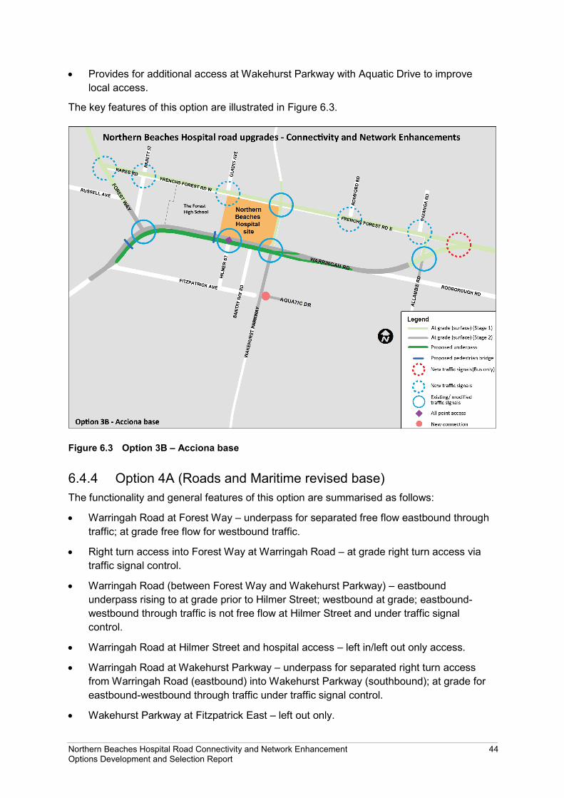
• Provides for additional access at Wakehurst Parkway with Aquatic Drive to improve local access.
The key features of this option are illustrated in Figure 6.3.
Figure 6.3 Option 3B – Acciona base
6.4.4 Option 4A (Roads and Maritime revised base) The functionality and general features of this option are summarised as follows:
• Warringah Road at Forest Way – underpass for separated free flow eastbound through traffic; at grade free flow for westbound traffic.
• Right turn access into Forest Way at Warringah Road – at grade right turn access via traffic signal control.
• Warringah Road (between Forest Way and Wakehurst Parkway) – eastbound underpass rising to at grade prior to Hilmer Street; westbound at grade; eastbound-westbound through traffic is not free flow at Hilmer Street and under traffic signal control.
• Warringah Road at Hilmer Street and hospital access – left in/left out only access.
• Warringah Road at Wakehurst Parkway – underpass for separated right turn access from Warringah Road (eastbound) into Wakehurst Parkway (southbound); at grade for eastbound-westbound through traffic under traffic signal control.
• Wakehurst Parkway at Fitzpatrick East – left out only.
Northern Beaches Hospital Road Connectivity and Network Enhancement 44 Options Development and Selection Report

• Wakehurst Parkway at Aquatic Drive – left out/right in.
• Does not provide full access at Hilmer Street/hospital entrance at Warringah Road.
• Provides for additional access at Wakehurst Parkway with Fitzpatrick East and Aquatic Drive to improve local access.
• Does not directly service the eastbound-westbound through traffic along Warringah Road (only separates out major afternoon peak right-turn movement at Wakehurst Parkway).
The key features of this option are illustrated in Figure 6.4.
Figure 6.4 Option 4A – Roads and Maritime revised base
Northern Beaches Hospital Road Connectivity and Network Enhancement 45 Options Development and Selection Report

6.5 Preferred Stage 2 option The performances of the short-listed options were assessed at a VM workshop with reference to the evaluation criteria presented in Section 6.2. The results are summarised in the following table.
Table 6.2 Summary of option evaluation scoring outcomes
Weighted score
Evaluation criterion Option 1A
Option 2B
Option 3B
Option 4A
Network performance 4 8 6 1
Engineering design and constructability 6 6 7 6
Environmental and community impacts 3.3 4.3 3.7 4.7
Urban design and landscape 2 4 2 3
Cost and economic return 8 7 6 6
Total average weighted score 4.4 6.5 5.2 3.1
Option 2B was identified as the preferred option for further design development and investigation.
6.6 Network justification review Subsequent to confirmation of Option 2B as the preferred option, a critical review was undertaken of the concept design, particularly in view of the number of surface road traffic lanes remaining unchanged with the addition of the four through traffic lanes. This considered key performance factors including LOS and intersection performance in the context of traffic congestion within the network for two scenarios (Year 2021 and Year 2036).
The following quality-of-travel based effective lane capacities were adopted for the various lane functions:
• Merge or turning lane – 600 vehicles per hour
• Surface through lane – 1100 vehicles per hour
• Underpass through lane – 1350 vehicles per hour.
Utilising these effective capacities, an assessment of the road network was carried out by converting the modelled traffic volumes to volumes to capacity ratios and assigning a measure of congestion performance ranging from high performing (indicating low congestion) to low performing (indicating high congestion).
Northern Beaches Hospital Road Connectivity and Network Enhancement 46 Options Development and Selection Report

The following qualitative scale was used to characterise network performance:
• High (free flow)
• Moderate–High (low congestion)
• Moderate
• Moderate–Low
• Low (high congestion).
Proposed lane configuration
The analysis identified that the proposed lane configuration of the corridor would operate at a good LOS with ample capacity over its length for both scenarios. However, there would be areas of localised congestion that would experience a lower LOS associated with turning movements at intersections including:
• Left turn from Forest Way to Warringah Road
• Right turn from Wakehurst Parkway (southbound) to Warringah Road (westbound).
There would, however, be capacity to enable buses to operate effectively in mixed traffic conditions along the Warringah Road surface road, without the need for indented bus bays or dedicated bus lanes. Buses would likely operate from the kerbside lanes with little detrimental impact on the movement of general traffic.
Reduced lane configuration
The review considered a reduction in the capacity (in each direction) along the Warringah Road surface lanes between Forest Way and Wakehurst Parkway by reducing the surface road through lanes from three to two in each direction.
The analysis indicated that the road system under this configuration would function at a lower LOS and have localised capacity issues. Localised congestion was particularly evident on Warringah Road between Wakehurst Parkway and Forest Way.
The model results also suggested that road-based public transport services operating in mixed traffic would be adversely affected by congestion. Operational speed targets would be unlikely to be met unless additional capacity was given to buses in terms of indented bus bays and dedicated bus lanes. Buses could not operate efficiently in such mixed conditions from the kerbside lane or elsewhere without being impeded by general traffic.
New on ramp
The analysis identified that the addition of an on ramp from Wakehurst Parkway (southbound) into the Warringah Road underpass (westbound) would improve network performance. This would allow both southbound and northbound traffic on Wakehurst Parkway to join westbound through traffic.
Conclusion
The review concluded that the proposed road system would operate at an appropriate LOS and provide an efficient road system for road users into the future. Any reduction in lane configuration along Warringah Road would result in higher congestion and a lower LOS that
Northern Beaches Hospital Road Connectivity and Network Enhancement 47 Options Development and Selection Report

would deteriorate over time. It would also reduce the effectiveness of the road upgrade and incapable of accommodating the projected increase in future traffic.
The proposed road system could accommodate kerbside bus stops without a requirement for bus indents. This would secure a lane (in each direction) for bus use or BRT, should such a facility be required in future.
Based on the analysis undertaken, the proposed configuration is the most effective means to manage the future traffic needs and enable efficient road network performance across the precinct.
6.7 Alternate alignment investigations 6.7.1 Background to investigations The community consultation undertaken from July to August 2014 included engagement with affected businesses on the southern side of Warringah Road. Following feedback, Roads and Maritime investigated a further three options for the Stage 2 works. These included a tunnel using two different construction methods, and an underpass with widening on the northern side of Warringah Road.
These design investigations were undertaken in collaboration with Transport for NSW, Health Infrastructure and the Department of Education and Communities, and included an assessment of cost and impacts on local properties, businesses, the high school and the new hospital.
6.7.2 Revised underpass option (Option 2B) The original proposed underpass option (Option 2B) with widening to the south of Warringah Road was revised to include additional features to improve network performance (refer Figure 6.5). This included the addition of an on ramp from Wakehurst Parkway (southbound) into the Warringah Road underpass (westbound) to allow southbound and northbound traffic on Wakehurst Parkway to join westbound through traffic.
Northern Beaches Hospital Road Connectivity and Network Enhancement 48 Options Development and Selection Report

Figure 6.5 Revised preferred underpass option
6.7.3 Alternate alignment options The following three alternate alignment options were identified for investigation:
• Tunnel (roadheader3 construction)
• Tunnel (cut and cover construction4)
• Underpass with widening to the north of Warringah Road.
The key features of each alignment are summarised as follows and shown in Figure 6.6, Figure 6.7 and Figure 6.8 respectively.
Tunnel (roadheader)
• Eastbound tunnel following the alignment of Warringah Road
• Westbound tunnel located to the south of Warringah Road
• Ramp from Wakehurst Parkway at Warringah Road to allow southbound traffic on Wakehurst Parkway to join westbound tunnel
• Avoids widening of existing Warringah Road carriageway
• Associated surface construction activities would be generally confined to the portal locations west of Forest Way and east of Wakehurst Parkway.
3 A roadheader is a type of heavy excavation machinery that utilises a special cutter-head mounted on the end of a boom that can swing up or down, left or right. Roadheaders usually deploy a loading device such as a conveyor for the removal of material sliced from the rock face to the rear of the machine for loading.
4 Cut and cover tunnelling is a method used to construct tunnels in locations where the tunnel’s profile is shallow, allowing for excavation to be carried out from the surface.
Northern Beaches Hospital Road Connectivity and Network Enhancement 49 Options Development and Selection Report

Tunnel (cut and cover)
• Single cut and cover tunnel extending from about 200 metres west of Hilmer Street to Wakehurst Parkway with an underpass at each end of the tunnel
• Tunnel generally running under the existing alignment of Warringah Road, deviating slightly to the north between Hilmer Street and Bantry Bay Road
• Ramp from Warringah Road at Wakehurst Parkway to allow southbound and northbound traffic on Wakehurst Parkway to join westbound tunnel
• While this alternate alignment avoids widening of Warringah Road, it could constrain future development of the hospital where the alignment deviates to the north as noted above
• Construction activities would occur along the entire affected length of Warringah Road.
Underpass and road widening (north)
• Alignment is the same as for the preferred option (Option 2B) except that it would deviate to the north at about 200 metres west of Hilmer Street to Wakehurst Parkway
• Ramp from Warringah Road at Wakehurst Parkway to allow southbound and northbound traffic on Wakehurst Parkway to join westbound tunnel
• Requires acquisition of part of the hospital site and would constrain future development on the hospital site; also requires part of the high school site
• Construction activities would occur along the entire affected length of Warringah Road.
Figure 6.6 Tunnel (roadheader option)
Northern Beaches Hospital Road Connectivity and Network Enhancement 50 Options Development and Selection Report

Figure 6.7 Tunnel (cut and cover option)
Figure 6.8 Underpass with widening to the north of Warringah Road
Northern Beaches Hospital Road Connectivity and Network Enhancement 51 Options Development and Selection Report
6.7.4 Consideration of alternate alignment investigations A comparison of the alternate alignments was undertaken by the project working group and project technical team with reference to the criteria in Section 6.2. This noted the following:
• The cost of the tunnel (roadheader) option would be more than double the cost of the revised preferred underpass option (ie widening to the south) while the tunnel (cut and cover) option would be 40 per cent more
• The estimated capital costs of the two underpass options are broadly similar
• Both tunnel options would have a similar level of road network performance compared to the revised preferred underpass option and the underpass with widening to the north of Warringah Road option, ie they would not provide a material increase in network performance for the additional cost
• Both tunnel options would incur greater operational costs associated with lighting, ventilation systems, monitoring, etc
• Construction of the underpass and road widening option could be completed by mid to late 2018 whereas construction of either of the two tunnel options would take up to an additional six months to complete
• Widening on the northern side of Warringah Road would avoid most of the direct impacts on the Bantry Bay shopping precinct, and residences and other businesses adjoining the shopping precinct
• Widening on the northern side of Warringah Road would:
− Require property to be acquired from both the Department of Education and Communities (DEC) (about 600 square metres) and Health Infrastructure (about one hectare)
− Reduce the developable area for the new hospital which would limit future expansion on the site and would require construction of a new high school before the hospital needs to expand as the hospital would need to acquire land from DEC
• Widening of Warringah Road to the north would have a significant impact on the long term expansion of the hospital campus effectively rendering the retained expansion zone unsuitable for future health facilities resulting in the need for a replacement area to be found in the medium term (5–10 years from opening)
• Widening to the north of Warringah Road would impact on DEC planning for any potential future reconfiguration of the school site to accommodate changes in student demographic factors
• Widening to the south of Warringah Road would require removal of the whole Bantry Bay shopping precinct
• Widening to the south of Warringah Road would offer a number of other key advantages when compared with widening to the north including:
− Less complicated construction staging
− Less disruption to traffic during construction
− Reduced amount of night works
Northern Beaches Hospital Road Connectivity and Network Enhancement 52 Options Development and Selection Report

− Less impact on The Forest High School during construction and following construction
− No need for land to be acquired from either Health Infrastructure or DEC
− No impact on the section of the hospital site set aside for future expansion
− No need to construct a new high school or combined primary and high school with associated costs and disruptions to the school and surrounding community
− Avoiding acceleration costs that would be incurred to complete all road works in time for the hospital opening.
In summary, neither of the tunnel options would provide better network performance commensurate with the additional cost. Other key disadvantages include longer construction periods and greater operational cost. While widening to the north of Warringah Road would avoid impacts to the businesses on the southern side of Warringah Road, it would have a number of unavoidable impacts, particular on future use of the hospital site and The Forest High School. On balance, the revised underpass southern alignment (Option 2B) was best determined by the NSW Government to best meet the project objectives and forms the preferred option for Stage 2.
Northern Beaches Hospital Road Connectivity and Network Enhancement 53 Options Development and Selection Report

Northern Beaches Hospital Road Connectivity and Network Enhancement 54 Options Development and Selection Report

7 Consultation
7.1 Consultation activities The submission of the State Significant Infrastructure application was publicly announced on 14 March 2014 and effectively marked the commencement of the consultation process. Roads and Maritime has consulted the community and key stakeholders since March, including two peak periods of consultation between March and April 2014 and July and August 2014. The aim of consultation was to inform the community and key stakeholders about the Project, the planning approval process and next steps and encourage feedback through written submissions.
Consultation activities included:
• Door knocking
• Regular community updates
• Community information sessions
• Meetings with key stakeholders including Council, stakeholders, community groups, potentially affected property owners. Ongoing monthly meetings with The Forest High School working group.
Further consultation was undertaken with affected business on the southern side of Warringah Road following identification of a preferred option for Stage 2. Consideration of the issues raised with regard to possible alternate alignments has been discussed in Section 6.7.
7.2 Issues Key issues raised by the community related to the following.
• Congestion
• Public transport
• Construction staging
• Environmental impacts
• Property acquisitions and adjustments
• On-street parking
• Local streets and rat-running
• Operation of The Forest High School
• Pedestrian and cyclist safety
• Access to the hospital from Wakehurst Parkway
• Proposed works on Frenchs Forest Road
Northern Beaches Hospital Road Connectivity and Network Enhancement 55 Options Development and Selection Report

Consultation has been undertaken for the Concept Proposal and the Stage 1 Hospital Works EIS. A wide range of suggestions has been made by the community with regard to aspects of the design. These are documented in Section 6.4.2 of the EIS which also provides a response either with regard to where an issue is considered in detail in the EIS or why an issue has not been considered further.
Some consultation has also been undertaken with regard to the Stage 2 Network Enhancement Works such as in relation to property impacts on the southern side of Warringah Road. Further consultation would occur as part of the Stage 2 concept design development and the related environmental assessment.
Northern Beaches Hospital Road Connectivity and Network Enhancement 56 Options Development and Selection Report

8 Next steps
8.1 Environmental impact assessment The EIS for the Concept Proposal and Stage 1 works was placed on exhibition from 21 October to 21 November 2014. Roads and Maritime is considering all submissions received and will provide responses to issues raised in a submissions report. The submissions report will be submitted to DP&E and will inform consideration of the Project by the NSW Minister for Planning.
Should the Project be approved by the Minister for Planning, it would be constructed and would operate in accordance with the mitigation measures in the EIS, the submissions report and the conditions of approval. Communication with the community would be ongoing throughout construction.
The EIS for the Stage 2 Network Enhancement Works will be placed on public exhibition by mid-2015.
8.2 Detail design Subject to obtaining planning approval, detail design will be completed, addressing relevant matters in the planning approval, commitments made in the EIS, and relevant matters raised in submissions and responded to in the submissions report. Construction of the Project would then follow.
Northern Beaches Hospital Road Connectivity and Network Enhancement 57 Options Development and Selection Report

Northern Beaches Hospital Road Connectivity and Network Enhancement 58 Options Development and Selection Report
9 References Department of Planning (2007) North East Strategy Draft Subregional Strategy, July 2007, Sydney, NSW.
Department of Premier and Cabinet (2011) NSW 2021: A Plan to Make NSW Number One, NSW Government, Sydney.
Department of Premier and Cabinet (2012a) NSW 2021 Performance Report, NSW Government, Sydney.
Department of Premier and Cabinet (2012b) Northern Beaches Regional Action Plan, NSW Government, Sydney.
Infrastructure NSW (2012) The State Infrastructure Strategy 2012-2032, Sydney.
NSW Government (2013) Draft Metropolitan Strategy for Sydney to 2013, March 2013, NSW Government, Sydney.
Roads and Maritime Services (2013) Key Roads Performance Report, June 2013, Sydney, NSW.
SMEC Australia (2013) Northern Beaches Hospital State Significant Infrastructure (SSI) Application Environmental Impact Statement for Stage 1 including Concept Design, Site Clearance & Preparatory Works, prepared for Health Infrastructure, October 2013, Sydney.
Transport for NSW (2012a) NSW Long Term Transport Master Plan, Sydney, NSW.
Transport for NSW (2012b) Northern Beaches Bus Rapid Transit (BRT) Pre-Feasibility Study, June 2012, Sydney, NSW.
Transport for NSW (2013) Sydney Clearways Strategy Keeping Sydney Moving, December 2013, Sydney NSW.
Northern Beaches Hospital Road Connectivity and Network Enhancement 59 Options Development and Selection Report


Appendix A Local area information
Northern Beaches Hospital Road Connectivity and Network Enhancement Options Development and Selection Report


A1 Regional context A1.1 Demographic profile Population growth within the North Subregion is expected to be modest. The North Subregional Strategy indicates a 15 per cent increase in population (an additional 40,000 people by 2036 on top of the current 238,000 population level) and a 26 per cent increase in employment (an additional 23,000 jobs by 2036 on top of the current 89,000 jobs). The majority of the employment growth is expected to occur at North Sydney, Chatswood and Dee Why/Brookvale.
While these population and employment land use forecasts do not include the hospital, between 2011 and 2036 there is a predicted increase of about 3,400 people and 4,900 jobs both within the surrounding Northern Beaches Hospital Precinct. This indicates a potential increase of 18 per cent and 43 per cent respectively over the next 25 years. While the forecasts do not specifically refer to the Northern Beach Hospital, it is expected that the number of jobs generated by the hospital could be included within the proposed increase of 4,900 jobs by 2036 in the precinct. Estimates of this population growth have been adopted in the strategic transport model developed by Roads and Maritime, which is based on updated small-area population and employment land use scenarios (Bureau of Transport Statistics, October 2012).
This notwithstanding, given the existing levels of congestion, the low housing densities throughout the area and consequent high levels of car trip generation per household, relatively small increases in population have the potential to exacerbate existing congestion.
A1.2 Transport characteristics There are currently no rail transport options in the Northern Beaches, and the heavy reliance on private vehicle trips creates significant road traffic management issues during peak periods. Within the Project study area there are three major State roads influenced by transport characteristics of vehicles within and across the Northern Beaches. Key roads covered by the Project include:
• Warringah Road (Route A38)
• Wakehurst Parkway
• Forest Way.
Warringah Road is a major State Road that runs from Dee Why in the east to Roseville Chase in the west. Warringah Road is the principal component of the road network as it is the main east-west route through the study area, providing access to Brookvale/Dee Why, Chatswood and Sydney CBD via multiple routes onto the Warringah Expressway. In the vicinity of the hospital site, Warringah Road carries 70–80,000 vehicles west of Wakehurst Parkway and 40–50,000 vehicles east of Wakehurst Parkway per weekday.
Wakehurst Parkway is a State Road that runs between Narrabeen in the north-east and Seaforth in the south providing further connections onto Sydney CBD via the Spit Bridge and Cremorne. In the vicinity of the proposed hospital site, Wakehurst Parkway carries 20-30,000 vehicles daily. It is a significant component of the existing road network as it
Northern Beaches Hospital Road Connectivity and Network Enhancement A-1 Options Development and Selection Report

functions as one of two key north-south routes through the Project area. The other key north-south route is Forest Way.
Forest Way is a State Road that consists of six lanes and links Frenchs Forest and Belrose to the north, continuing onto Mona Vale Road. Forest Way carries about 45,000 vehicles daily north of Warringah Road.
Warringah Road, Forest Way and Wakehurst Parkway north are designated as higher mass limit roads (Metropolitan Road Freight Hierarchy on the State Road Network – Practice Note (Transport for NSW, 2011)), that can take up to 68 tonne semi-trailers and B-Doubles. Heavy freight vehicles make up about three to five per cent of all vehicles on these routes. The freight routes serve end destinations in the industrial and commercial areas of Frenchs Forest, Brookvale, Manly Vale, Dee Why and Warriewood.
As noted in Section 3.1.3, the Long Term Transport Master Plan identifies the transport corridor connecting Dee Why and Chatswood, through Frenchs Forest, as a strategic transport corridor that would continue to represent travel demands between centres in Metropolitan Sydney over the long term. In addition to the existing and long term strategic transport needs both to and across the Northern Beaches Hospital Precinct, the Northern Beaches Hospital and associated precinct growth would act to generate traffic from other metropolitan centres to the Northern Beaches Hospital Precinct, further defining transport characteristics of the precinct in the long term. This would include growth for light freight associated with medical-related development throughout the precinct.
A2 Existing road network conditions A2.1 Road network The study area is served by three State-controlled arterial roads:
• Warringah Road which provides access to Brookvale/ Dee Why, Chatswood and Sydney CBD via multiple routes onto the Warringah Expressway
• Forest Way which provides access to Belrose and onto Mona Vale Road and suburbs towards the north
• Wakehurst Parkway (north) which provides access to Narrabeen and onto Mona Vale and Wakehurst Parkway (south) which connects to Seaforth and onto Sydney CBD via the Spit Bridge and Cremorne.
The study area contains a number of key intersections and local roads that also influence traffic characteristics; these are discussed as follows.
Warringah Road – Woodlands Road/ Arthur Street to Allambie Road
The section of Warringah Road from Woodlands Road/Arthur Street to Allambie Road is 3.8 kilometres long. To the west of Forest Way, it largely serves residential land uses in a confined corridor, while east of Forest Way, it operates in a much wider landscaped reserve and fronts schools, shopping centres and industrial/business parks.
Warringah Road has a six lane carriageway configuration with a wide central median. It has eight sets of signalised intersections (at an average spacing of 500 metres) to accommodate
Northern Beaches Hospital Road Connectivity and Network Enhancement A-2 Options Development and Selection Report

pedestrian crossing opportunities and traffic accessing Warringah Road. A number of these and some unsignalised intersections have dedicated right turn bays allowing access to side streets. The major intersections of Starkey Street, Forest Way and Wakehurst Parkway also have dedicated left turns.
The posted speed limit on Warringah Road is generally 70 kilometres per hour. There are three 40 kilometres per hour school zones:
• Our Lady of Good Counsel Primary School at Cook Street
• Frenchs Forest Primary School at Forest Way
• The Forest High School near Hilmer Street.
Lane widths are relatively narrow, typically 3.1 metres which is below the optimal arterial lane width of 3.5 metres. Turning lanes are approximately 3.0 metres wide. The horizontal alignment is generally straight. Where it does bend, the curve radius is greater than the minimum radius of 150 metres for the 70 kilometres per hour posted speed limit. The terrain is slightly hilly throughout but the road gradient is within the desirable maximum of 4-6 per cent for the road environment. On street parking is prohibited on both sides of Warringah Road.
Wakehurst Parkway (south): Frenchs Forest Road to Aquatic Drive
Wakehurst Parkway between Frenchs Forest Road and Aquatic Drive is mostly surrounded by bushland on both sides of the road. The majority of Wakehurst Parkway is two lanes undivided but widens out on either side of Warringah Road to six lanes to cater for right turn lanes and a dedicated bus lane. The only access to Wakehurst Parkway in this section is through the two signalised intersections with Frenchs Forest Road and Warringah Road. Aquatic Drive and Fitzpatrick Avenue East do not connect to Wakehurst Parkway.
The posted speed limit along this section of Wakehurst Parkway is 70 kilometres per hour. On street parking is prohibited on both sides of the road. Lane widths are typically 3.4 metres which is close to the optimal arterial road lane width of 3.5 metres. Both sides have road shoulders of 1-1.5 metres width. The topography of this section of Wakehurst Parkway is hilly with a gradient of 2-6 per cent that is within the desirable maximum for the road environment. The road alignment is straight throughout.
Frenchs Forest Road East and West: Warringah Road to Forest Way
Frenchs Forest Road is a council controlled local road 1.8 kilometres in length, running parallel to Warringah Road. Land use around this road is predominately residential, with industrial/commercial land to the east of Wakehurst Parkway, and residential land and a high school to the west of Wakehurst Parkway.
The intersection of Frenchs Forest Road and Wakehurst Parkway is controlled by traffic signals. The remaining intersections along its length are unsignalised as they generally connect to other local roads. Frenchs Forest Road is generally two lanes undivided, with on street parking allowed on both sides. On its eastern half, buses travel in the westbound direction only.
Northern Beaches Hospital Road Connectivity and Network Enhancement A-3 Options Development and Selection Report
The posted speed limit on this section of the road is 50 kilometres per hour. The road is not accessible for vehicles with more than a three tonnes load, buses excepted. There are several traffic calming devices including speed humps, marked pedestrian crossings and zig zag lines to enforce low traffic speeds as a result of the 40 kilometres per hour school zone outside The Forest High School.
Forest Way: Warringah Road to Naree Road
This section of Forest Way between Naree Road and Warringah Road is 400 metres in length. It contains intensive land uses including a shopping centre and associated car park, a school, residential areas and small businesses. It is a six lane divided carriageway and it has a mid-block signalised pedestrian crossing. Rabbett Street to the north is used by buses and its intersection is limited to left out only onto Forest Way.
The posted speed along most of this section is generally 70 kilometres per hour. On street parking is prohibited along its length. Forest Way is mostly flat and straight with lane widths of about 3.1 metres which is below the optimal arterial road lane width of 3.5 metres.
A2.2 Traffic activity Daily traffic volumes and patterns
The range of daily traffic volumes on the key roads are currently in the order of:
• Warringah Road: 42,000 to 79,000 vehicles per day
• Wakehurst Parkway: 23,000 to 28,000 vehicles per day
• Forest Way: 44,000 to 45,000 vehicles per day
• Frenchs Forest Road: 4,000 to 20,000 vehicles per day.
Figure A1 illustrates the daily traffic volumes throughout the study area road network. The highest traffic volumes in the precinct are generally on Warringah Road west of Wakehurst Parkway.
The daily pattern of activity on Warringah Road (refer Figure A2) is generally constant in terms of traffic volume. The morning peak periods are much the same throughout the working week, while the afternoon peak steadily increases from Monday to Thursday and splits on Fridays. The Saturday peak is of a similar magnitude to the week day peaks.
Northern Beaches Hospital Road Connectivity and Network Enhancement A-4 Options Development and Selection Report

Figure A1 Average daily traffic volumes, 2012
Location: Warringah Rd, E Daines Parade, Beacon Hill, 21-27 February 2011 – Source RISS
Figure A2 Daily traffic pattern by day of week (Warringah Road)
Hourly traffic volumes and patterns
The typical hourly pattern of traffic in the precinct is shown in Figure A3 for Warringah Road and Figure A4 for Wakehurst Parkway. These show conventional commuter peaks. The two-hour morning peak period from 7:00am to 9:00am has 15.7 per cent of daily traffic. The two-hour evening peak period from 4:00pm to 6:00pm has 15.1 per cent of daily traffic.
Northern Beaches Hospital Road Connectivity and Network Enhancement A-5 Options Development and Selection Report

Location: Warringah Road, W Melwood Avenue, Forestville, 21-27 February 2011 – Source RISS
Figure A3 Traffic pattern by hour of day (Warringah Road)
Location: Wakehurst Parkway, S Oxford Falls Road, Frenchs Forest, 21-27 February 2011 – Source RISS
Figure A4 Traffic pattern by hour of day (Wakehurst Parkway)
Each individual peak hour has its own travel pattern. In the mornings, the earlier hour contains more commuters passing through the area whereas the second hour is more about the diverse movement associated with local activities such as trips to schools, shops and businesses. In the evening, the reverse generally applies.
Northern Beaches Hospital Road Connectivity and Network Enhancement A-6 Options Development and Selection Report

Heavy vehicles and freight
Transport planners have established a freight hierarchy for the State Road network to give weight to the importance of freight movement (documented in Metropolitan Road Freight Hierarchy on the State Road Network – Practice Note, Transport for NSW 2011). The freight hierarchy concept designates the State Road network as primary, secondary and tertiary freight routes, largely as a reflection of freight vehicle volumes, strategic freight function and accessibility offered for heavy vehicles.
The freight hierarchy concept assists in decision-making about operational and route development priorities, maintenance practices and design standards that could be adopted. The hierarchy assists in determining desirable characteristics to be pursued when a road is upgraded. For example, a higher designation in the hierarchy points to the use of more generous dimensions being appropriate for such things as lane widths, headroom clearances, turning paths at intersections, queue lengths, etc to better accommodate larger heavy vehicles and allow them to safely mix with other road users. A higher designation may point to greater weight being placed on intersection upgrades such as grade separations. A higher designation may aid investment decisions that give relatively higher consideration to the contribution of freight transport to economic productivity.
The road system, particularly the State controlled road network, is required to be made available for general use by all vehicle types and State controlled roads are more readily used by vehicles carrying freight. Freight is carried in vehicles ranging from large articulated vehicles down to light commercial vehicles such as vans and station wagons. Vehicles are classified into a range of groups, broadly based on size and type:
• Light vehicles, including privately owned cars and a variety of small commercial vehicles carrying freight, such as station wagons and vans (Austroads Classes 1-2)
• Heavy freight rigid vehicles, including small and medium rigid trucks (Austroads Classes 3-5)
• Heavy freight articulated vehicles, including large semi-trailers and B-double articulated trucks (Austroads Classes 6-12).
Warringah Road, Wakehurst Parkway and Forest Way are designated as tertiary freight routes as the proportions of heavy freight vehicles in this section are at 3–5 per cent of all vehicles. Warringah Road, Wakehurst Parkway (north) and Forest Way are also designated as Higher Mass Limit (HML) roads that can take up to 68 tonne semi-trailers and B-Doubles.
The profile of vehicle types on Warringah Road during morning and afternoon peak periods is shown in Table A1. Heavy freight vehicles (Vehicle Classes 3-12), particularly those at the upper end of the scale, place great stress on the road network in terms of travel speed, lateral and headroom clearances, manoeuvrability, and pavement impact.
Northern Beaches Hospital Road Connectivity and Network Enhancement A-7 Options Development and Selection Report

Table A1 Indicative freight traffic volumes
Weekday peak hours (6-10AM & 3-7PM) traffic volume by road
Vehicle type (size) Warringah Rd
(Hilmer St) Wakehurst Parkway
(Warringah Rd)
Forest Way (Naree Rd)
Frenchs Forest Rd
(Romford Rd)
All types of vehicles 45,800 29,000 24,000 9,200
Light (Classes 1-2) 44,100 (96.3%) 27,800 (95.9%) 22,700 (94.6%) 9,000 (97.8%)
Heavy freight rigid (Classes 3-5)
1,600 (3.5%) 1,100 (3.8%) 1,200 (5.0%) 200 (2.2%)
Heavy freight articulated (Classes 6-12)
100 (0.2%) 100 (0.3%) 100 (0.4%) 0
Source: Roads and Maritime traffic counts, March 2012
A2.3 Travel speeds The Key Roads Performance Report (Roads and Maritime 2013) outlines how well the road network in Greater Sydney is performing during peak periods, in terms of travel time during the morning and afternoon peak periods, as gathered from global positioning system (GPS) surveys of the routes.
The most recent report (June 2013) provides trip times calculated using weekday traffic information from 1 March 2013 to 31 May 2013 (excluding public holidays). Average speeds on key routes in the Northern Beaches are summarised in Table A2.
Table A2 Average peak period speeds on selected major Northern Beaches routes
Route Distance (km) morning peak inbound average speed (km/h)
afternoon peak outbound average speed (km/h)
Warringah Road (Frenchs Forest–Roseville)
7.1 39 32
Warringah Road (Frenchs Forest–Brookvale)
5.3 33 27
Forest Way 6.0 34 45
Mona Vale Road 20.1 42 41
Pittwater Road (Mona Vale–Brookvale)
10.4 24 30
Pittwater Road (Balgowlah–Brookvale)
5.8 22 25
Military Road - Spit Road - Manly Road
6.6 20 27
Between 21-22 May 2013, Roads and Maritime undertook speed surveys along Warringah Road between Woodlands Road and Government Road. The surveys recorded the travel
Northern Beaches Hospital Road Connectivity and Network Enhancement A-8 Options Development and Selection Report

time and speed, and encompassed a total of 58 survey runs during the representative two-hour morning and afternoon peak periods. The survey results are summarised in Table A3.
Table A3 Average peak period travel speeds (km/h) on sections of Warringah Road
Time period
Woo
dlan
ds R
d–
Star
key
St
Star
key
St–A
ltona
A
ve
Alto
na A
ve–F
ores
t W
ay
Fore
st W
ay–H
ilmer
St
Hilm
er S
t–W
akeh
urst
Pk
wy
Wak
ehur
st P
kwy–
Alla
mbi
e R
d
Alla
mbi
e R
d–G
over
nmen
t Rd
Total
730m 680m 760m 500m 260m 850m 920m 4700m
Eastbound morning peak
7am–8am 44 33 13 36 38 43 46 20
8am–9am 49 45 26 35 44 32 38 32
Average 47 39 20 36 41 38 42 26
Eastbound afternoon peak
4pm–5pm 43 55 25 44 54 37 38 34
5pm–6pm 31 33 16 34 44 30 31 25
Average 37 44 21 39 49 34 35 30
Westbound morning peak
7am–8am 53 29 32 35 21 6 31 15
8am–9am 49 45 41 33 36 19 38 24
Average 51 37 37 34 29 13 35 20
Westbound afternoon peak
4pm–5pm 48 23 64 52 44 33 43 37
5pm–6pm 50 30 56 44 43 15 40 28
Average 49 23 60 49 44 24 42 33
Source: Roads and Maritime Services, from Austraffic travel time survey 21–22 May 2013.
The results of the Warringah Road speed surveys indicate the variability of peak period average travel speeds along the stretch of Warringah Road. The survey results indicate that speeds during the morning peak period are generally slower in both directions compared with the afternoon peak period. Key slow points are the eastbound approach to Forest Way and the westbound approach to Wakehurst Parkway. The first hour travel speed from the survey on this section was six kilometres per hour, which is comparable to average walking speed.
Northern Beaches Hospital Road Connectivity and Network Enhancement A-9 Options Development and Selection Report

A2.4 Intersection performance Intersection performance concepts
The Warringah Road corridor intersects with a number of other arterial roads (classified State controlled roads); medium order sub-arterial roads; and lower order collector/local roads (generally council controlled roads). In terms of network management, greater emphasis is put on minimising delays to the higher number of through travelling vehicles on higher order roads at the expense of the lower number of vehicles waiting to get on or off lower order roads. The higher order State roads crossing the Warringah Road corridor are Forest Way and Wakehurst Parkway. Allambie Road is the only middle order regional road. All other roads including Frenchs Forest Road are lower order local (council) roads.
Forest Way and Wakehurst Parkway are key north-south routes carrying significant traffic volumes. The intersections of these higher order roads control the rhythm of traffic along it. As a rule, travel speeds are slower on the approaches to these intersections not only as a result of queuing on the direct approach to the intersection but also from the upstream effects of traffic queuing back through adjacent intersections and downstream effects of flow back from merging and queuing at other intersections.
These effects become more acute as the traffic network approaches gridlock. In such cases, small surges of arrivals or incidents (eg crashes or breakdowns) have major repercussions for traffic flow and the resultant congestion can take hours to clear.
Traffic models have been developed for the assessment of intersection operation, some being more suitable to analysing complex interactions. These models commonly assess operations in terms of their total intersection delay which can be translated to a LOS (level of service). This is a policy-oriented performance parameter that acts a guideline to express acceptability of delay. It is a descriptor of the quality of intersection operation reflecting, in a general way, the theoretical tolerance the community has to delay at intersections. Conventionally (based on arguable expectations of ideal-world, free-flowing arterial road conditions), it ranges from A indicating good intersection operation to F indicating saturated conditions with long delays and queues.
Network effects also affect the performance of individual intersections as constraints on parts of the network may limit the amount of traffic passing through the intersection, disguising gridlocked conditions. In the case of the intersections surrounding the proposed hospital, severe constraints are being experienced on one or two movements only, yet these effects are reduced when considering the overall intersection performance. As well, the network constraints limit the amount of traffic that can enter an intersection.
Table A4 summarises the particular LOS concepts adopted for the Project. Other performance measures have also been adopted and these are explained in Section 5 when discussing the transport performance of options.
Northern Beaches Hospital Road Connectivity and Network Enhancement A-10 Options Development and Selection Report

Table A4 Level of service definitions for intersection performance
Level of Service Average delay per vehicle (sec/veh) Description of operational quality of traffic signals
A <14 Low loading and good operation
B 15–28 Good with acceptable delays and spare capacity
C 29–42 Satisfactory
D 43–56 Operating near ideal capacity
E 57–70 Operation generally deemed at approaching effective capacity for signals. Additional capacity may be desirable on particular approaches.
F1 70–90 Deemed at capacity, particularly on low and middle order intersections. Motorists would experience long delays and queues on multiple approaches and extra capacity may be needed.
F2 140+ Deemed at effective capacity on higher order intersections. Motorists would experience long delays and queues and extra capacity may be needed.
Adapted from Austroads and RMS Guide to Traffic Generating Developments, 2002.
Existing intersection performance analysis
Traffic modelling analysis was undertaken for all the key intersections on the Warringah Road corridor and the surrounding network using the application of a detailed micro-simulation model (VISSIM) which is able to incorporate the inter-dependent effects of up and downstream constraints of intersections, public transport interactions and conventional assignment of traffic across the network. VISSIM produces summaries of intersection performance in the form of average delay per vehicle, and also for individual legs and approaches. The analysis pointed to a number of key intersections around the proposed hospital being highly congested, indicating that drivers can experience extended delays getting through the area.
The VISSIM model results confirm the travel surveys and community feedback that the Warringah Road and Wakehurst Parkway intersection often experiences heavily congested, gridlock-like conditions, particularly during the morning peak. These often have knock-on effects at the Wakehurst Parkway/Frenchs Forest Road intersection, substantially compromising its effectiveness.
With the current layout, there are fundamental limitations to managing high volumes of intersecting main road traffic. The modelling results point to appreciable average delays and above average delays during individual traffic cycles. Average delays on a number of individual approaches exceed two minutes each with average queues extending in the hundreds of metres.
Commentary regarding individual intersections is summarised below along with particular characteristics of traffic in the Frenchs Forest network/Warringah Road corridor that complicate the network’s operation:
Northern Beaches Hospital Road Connectivity and Network Enhancement A-11 Options Development and Selection Report

• A high volume of right turn movement from Warringah Road into Wakehurst Parkway heading south
• A high volume of right turn movement from Wakehurst Parkway into Warringah Road heading west
• A high demand for weaving traffic between Wakehurst Parkway and Forest Way. Motorists must make the lateral change of 2-3 lanes within a limited length of Warringah Road amongst substantial volumes of east-west through traffic
• The volumes of traffic are prone to causing congestion when insufficient space is available to merge with the stream of traffic
• Loading and unloading at bus stops can cause considerable difficulties for traffic flow in the kerbside lane
• The regular call-up of pedestrian phases at signalised intersections can cause cumulative interruption to traffic during peak hours and result in queuing at preceding intersections.
Traffic signal coordination
Traffic signal coordination for the Warringah Road corridor is not fully coordinated for the entire length, however there are substantial segments of roadway that operate inter-dependently. Within the Forest District, the Warringah Road/ Wakehurst Parkway intersection dominates the surrounding intersections.
A2.5 Frequency and change in congestion An indication of the changing pattern of congestion of the Warringah Road traffic system and particularly the recurrence of heavy congestion (which is a good representation of the typical modelled day) is given by records kept of the total daily amount of impeded traffic passing over all stop line detectors at the intersection approaches of Warringah Road and Wakehurst Parkway. During the traffic signal green phase, stop line detectors record activity when traffic is stationary and not when they have a constant flow of traffic travelling over them.
The modelled day is considered to be average or slightly above average for weekdays. The pattern of congestion suggests that average weekday congestion levels (typical of the modelled traffic network) are exceeded on 109 days or 42 per cent of occasions each year. The more extreme events are likely due to external network effects such as major congestion, breakdowns and changing heavy demands that combine to have major knock-on effects throughout the network.
Another indication of the pattern of congestion and hence reliability of traffic operation is given by three queue detectors on the westbound approach of Warringah Road at the same intersection. These queue detectors are set back about 150 metres from the stop line. They record stationary traffic sitting on the detectors during the approach’s green time and the pattern of congestion suggests that average weekday levels (typical of the modelled traffic network) are exceeded on 130 days or 52 per cent of occasions each year.
The traffic signal detector data demonstrates that traffic queues are present during most peak periods but there also is a relatively high frequency of very heavy congestion. The
Northern Beaches Hospital Road Connectivity and Network Enhancement A-12 Options Development and Selection Report

pattern helps explain the volume of public complaint about the intersection and surrounding network over the years and supports the case for capacity enhancement.
A3 Road safety A3.1 Historical overview The crash history of the major roads in the study area (Warringah Road, Forest Way, Wakehurst Parkway and Frenchs Forest Road) has been analysed for the full calendar year periods 2008–2012, the latest available at the time of writing. There were a total of 458 crashes on the precinct roads in the five years to 2012. Of these, there was one fatal crash and 175 injury crashes resulting in one person killed and 224 people injured. There has been no noticeable trend in the annual number of crashes over that period as shown in Figure A5, although the number of casualty crashes shows a slight upward trend.
Figure A5 Historical crash numbers (2008-2012)
A3.2 Casualty crash rates and types The zones where the crash rates are highest are on Warringah Road just west of Wakehurst Parkway to Starkey Street, Wakehurst Parkway and Forest Way. Elsewhere, crash rates are typical of that style of urban road. Table A5 summarises the number of crashes by crash type that occurred on each of the major roads that are included in the study area.
Congestion-related crash types (rear-end collisions, intersection crashes) feature on all three arterial roads. Other crash types that are potentially affected by road upgrade options include:
• Warringah Road:
− Lane changes, likely associated with the high weaving volumes
− Crashes involving vulnerable users (mostly cyclists)
− Intersection approaches crashes.
82
101
82
9994
5160
67
45
59
34 34
37
4031
0
20
40
60
80
100
120
2008 2009 2010 2011 2012
No of All reported crashes per year No of Non-casualty crashes per yearNo of Casualty crashes per year
Northern Beaches Hospital Road Connectivity and Network Enhancement A-13 Options Development and Selection Report
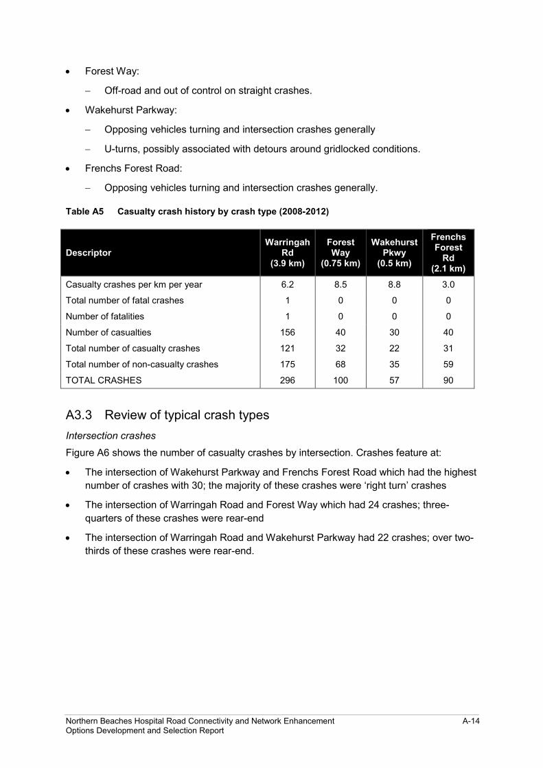
• Forest Way:
− Off-road and out of control on straight crashes.
• Wakehurst Parkway:
− Opposing vehicles turning and intersection crashes generally
− U-turns, possibly associated with detours around gridlocked conditions.
• Frenchs Forest Road:
− Opposing vehicles turning and intersection crashes generally.
Table A5 Casualty crash history by crash type (2008-2012)
Descriptor Warringah
Rd (3.9 km)
Forest Way
(0.75 km)
Wakehurst Pkwy
(0.5 km)
Frenchs Forest
Rd (2.1 km)
Casualty crashes per km per year 6.2 8.5 8.8 3.0
Total number of fatal crashes 1 0 0 0
Number of fatalities 1 0 0 0
Number of casualties 156 40 30 40
Total number of casualty crashes 121 32 22 31
Total number of non-casualty crashes 175 68 35 59
TOTAL CRASHES 296 100 57 90
A3.3 Review of typical crash types Intersection crashes
Figure A6 shows the number of casualty crashes by intersection. Crashes feature at:
• The intersection of Wakehurst Parkway and Frenchs Forest Road which had the highest number of crashes with 30; the majority of these crashes were ‘right turn’ crashes
• The intersection of Warringah Road and Forest Way which had 24 crashes; three-quarters of these crashes were rear-end
• The intersection of Warringah Road and Wakehurst Parkway had 22 crashes; over two-thirds of these crashes were rear-end.
Northern Beaches Hospital Road Connectivity and Network Enhancement A-14 Options Development and Selection Report

Figure A6 Casualty crashes at intersections
Crashes involving right turns and U-turns
Figure A7 shows casualty crash locations of intersection-related ‘right turn’ (opposing vehicle) type crashes. The highest incidence of such crashes was at Wakehurst Parkway/Frenchs Forest Road where 20 of the 22 right turn crashes involved the key vehicle turning into Frenchs Forest Road East colliding with a southbound vehicle on Wakehurst Parkway. Similar crash types are experienced to a lesser degree at Forest Way/Naree Road and Warringah Road/Allambie Road. Crashes involving U-turns are over-represented on Wakehurst Parkway as motorists attempt to work around no right turn restrictions. Any upgrade of these intersections would need to address these crash types.
Figure A7 Right turn casualty crash clusters
Crashes involving vulnerable users
Figure A8 shows the locations of vulnerable user casualty crashes – crashes involving pedestrians, pedal cyclists and motorcyclists. Warringah Road had higher than average casualty crash rates for both motorcyclists and pedal cyclists. There were nine crashes involving a pedal cyclist on Warringah Road.
Northern Beaches Hospital Road Connectivity and Network Enhancement A-15 Options Development and Selection Report

Figure A8 Casualty crashes involving vulnerable users
A4 Public transport demand and performance There is no rail service on the Northern Beaches and the closest train station that bus services focus on is Chatswood, some nine kilometres to the west. The other notable transport hub is at Manly (about 10 kilometres away) which is the terminus for ferry services. Buses are the primary mode of non-car travel that services the area.
A4.1 Bus routes Bus routes operating in the study area are listed below along with their ultimate destinations. Currently there are eight bus routes operated by Sydney Buses (refer Table A6), and nine bus routes operated by Forest Coach Lines (refer Table A7). The majority of buses travel towards Chatswood and Sydney CBD in the morning peak with the reverse occurring in the afternoon peak.
Table A6 Sydney Buses services
Route Nature of service and destinations
136 Daily service between Manly and Chatswood
137 Weekday limited stop service between Bantry Bay and Chatswood
142 Daily between Allambie and Manly
169 Daily between Manly and Sydney CBD
173 Weekday peak hour service between Narraweena and Milsons Point
E66 Weekday peak hour express service between Allambie and Sydney CBD
E69 Weekday peak hour express service between Manly and Sydney CBD
L60 Weekday peak hour limited stop service between Mona Vale and Chatswood
Northern Beaches Hospital Road Connectivity and Network Enhancement A-16 Options Development and Selection Report

Table A7 Forest Coach Lines services
Route Nature of service and destinations
270 Daily service between Terrey Hills and Sydney CBD
276 Weekday school hours service between Belrose and Warringah Mall
278 Weekday peak hour and weekend service between Killarney Heights and Chatswood
279 Weekday services between Frenchs Forest and Chatswood
280 Daily service between Warringah Mall and Chatswood
281 Daily service between Davidson and Chatswood
282 Daily afternoon service between Davidson/Belrose and Chatswood
283 Daily service between Belrose and Chatswood
284 Daily service between Duffys Forest and Chatswood
L70 Weekday peak hour limited stop service between Terrey Hills and Sydney CBD
A4.2 Bus performance In 2012, prior to the LTTMP and Northern Beaches Hospital Project taking shape, a study was commissioned by Roads and Maritime into potential bus priority measures that might be pursued in the short and medium term for the Warringah Road corridor. As part of these investigations, bus travel surveys were commissioned to identify the bus travel speed performance of services in this location. The survey recorded travel times for Route 136 between Roseville and Dee Why, and Route 280 between Chatswood and Allambie Heights, during the major direction of travel in the morning and afternoon peak periods. The survey results are summarised in Table A8.
Table A8 Warringah Road peak hour bus travel speeds, 2012
Bus route Morning peak – westbound Average travel speed
Afternoon peak –eastbound Average travel speed
136 22.9 km/h 28.2 km/h
280 12.5 km/h 20.9 km/h
The NSW targeted average speeds in operation at the time were 20-25 kilometres per hour over the length of the bus route. The target was generally met with the exception of Route 280. This route, which runs along Warringah Road between Allambie Road and Forest Way, had travel speeds below the target. Much of the delay was due to intersection congestion, particularly at:
• Warringah Road from Allambie Road – about eight minutes delay
• Rabbett Street – about three minutes delay
• Warringah Road – about two minutes delay.
Northern Beaches Hospital Road Connectivity and Network Enhancement A-17 Options Development and Selection Report

The bus travel surveys and analysis also identified slow points on the bus network in that area by analysing GPS data collected from buses tracked through Roads and Maritime’s Public Transport and Priority System (PTIPS). Bottlenecks were noticeable at the following intersections:
• Forest Way/Naree Road
• Warringah Road and Forest Way
• Frenchs Forest Road and Wakehurst Parkway
• Warringah Road and Starkey Street.
Northern Beaches Hospital Road Connectivity and Network Enhancement A-18 Options Development and Selection Report