Embed Size (px)
Citation preview

St. Lucie County, Florida
• Canal Crossing Criteria • Drainage and Irrigation Connections • Spoil Disposition • Utility Construction • Other Uses and Requirements
North St. Lucie River Water Control District 14666 Orange Avenue
Fort Pierce, Florida 34945 (772) 461-5050
Fax: (772) 461-9446 www.nslrwcd.org
P:\74-0901\Permit Application Documentation\Permit Manual\Rules Rev 03-25-2010.doc
North St. Lucie River Water Control District
Permit Information and Criteria Manual For
Use Of or Connection To Works of the District

PERMIT INFORMATION AND CRITERIA MANUAL
USE OF OR CONNECTION TO WORKS OF THE DISTRICT
Effective: October 1, 1991
Revised by the Board: January 27, 2000
Revised by the Board: February 27, 2003
Revised by the Board: December 7, 2007
Revised by the Board: March 25, 2010
North St. Lucie River Water Control District 14666 Orange Avenue
Fort Pierce, Florida 34945 (772) 461-5050
Fax: (772) 461-9446
PERMIT INFORMATION AND CRITERIA MANUAL
North St. Lucie River Water Control District

TABLE OF CONTENTS
P A G E SECTION 1: INTRODUCTION 1 SECTION 2: RULES FOR USE OF OR CONNECTION TO WORKS 1 OF THE DISTRICT
A. Permits Required 1 B. Permit Fees and Review Deposit 2 C. Inspection/Project Certification 2 D. Pre-Application Meeting 2 E. Permit Application Requirements 2 F. Installation and Maintenance Responsibility 4
SECTION 3: CANAL CROSSING CRITERIA 4
A. Canal Crossing Policy 4 B. Application for Canal Crossing Permit 4 C. Culverted Crossing 5 D. Bridges 5 E. Crossing Criteria Flexibility 6
SECTION 4: DRAINAGE AND IRRIGATION CONNECTIONS 6 TO DISTRICT CANALS
A. Public Road Drainage 6 B. Drainage Connections 7 C. Irrigation Connections 8 D. All Connections 8
SECTION 5: OPEN CHANNEL CONNECTIONS 9 SECTION 6: SPOIL DISPOSITION 9 SECTION 7: UTILITY CONSTRUCTION 9
A. Aerial Crossings 9

B. Over-Water Crossings 10 C. Under-Canal Crossings 10 D. Utility Paralleling Canal or Right-of-Way 11
SECTION 8: OTHER USES AND REQUIREMENTS 11
A. Water Control Structure Installation and Operation 11 B. Beehives 12 C. Use of Canal Berms for Access 12 D. Fencing of Canal Right-of-Way 13 E. Gates in Canal Right-of-Way 13
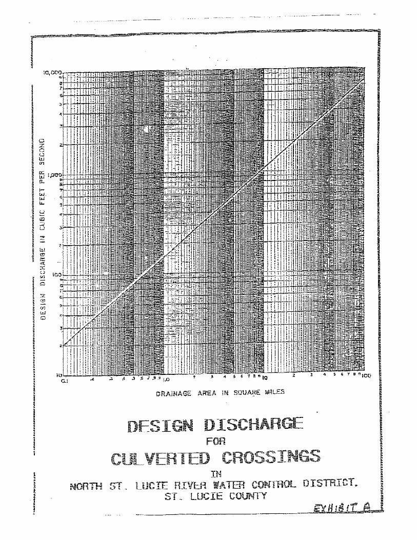
E X H I B I T S EXHIBIT A: Design Discharge for Culverted Crossings EXHIBIT B: Culverted Canal Crossing EXHIBIT C: Gravity Drainage Connection EXHIBIT D: Restoration of Canal Berms EXHIBIT E: Overhead Utility Crossing EXHIBIT F: Under-Canal Utility Crossing EXHIBIT G: Typical Connection Detail
North St. Lucie River Water Control District -1- Permit Information and Criteria Manual
SECTION 1 INTRODUCTION
The purpose of this Permit Information and Criteria Manual for Use of or Connection to Works of the District (“Manual”) is to provide information describing the criteria and permitting requirements relating to the utilization of, and connection to, the works of the North St. Lucie River Water Control District (“District”). This Manual should be used by permit applicants to prepare permit applications. It will be used as a guideline by the District staff to evaluate applications and proposals for permits. The criteria and requirements contained herein are subject to change, without notice, by the Board of Supervisors of the District. The Board may waive strict application of the criteria appearing in this Manual when such action is determined to be in the best interest of the District and general public, consistent with the objectives of the District.
SECTION 2 RULES FOR USE OF OR CONNECTION TO WORKS OF THE DISTRICT
A. Permits Required No utility or other improvement shall be constructed across, under, along or within a canal or right-of-way over which the District has jurisdiction, nor shall any use whatsoever occur within a District right-of-way or easement, unless a valid application for a construction or use permit has been approved and issued by the District. No land alteration or site development altering surface water runoff for any property within the jurisdictional limits of the District shall occur unless a valid permit application has been reviewed and approved by the District. A map showing the general location of the District’s canal rights-of-way may be purchased at the District office, or is available on the District website at http://www.nslrwcd.org. The permit application process consists of two parts which both require District approval; authorization for construction and inspection/project certification. Upon District approval of the application submittal, the applicant will receive a permit, or, at the Board of Supervisor’s discretion, a Letter of No Objection for construction authorization. After construction is complete, the applicant shall complete the Inspection/Project Certification requirements outlined below for the permit process to be deemed complete. Any proposed use, crossing, or connection to works of the District shall not inhibit maintenance of the canal system. Easements may be required to facilitate uninterrupted maintenance access to the works of the District. Alternative arrangements for maintenance at the full expense of the project applicant may be considered at the Board’s discretion on a case-by-case basis.

North St. Lucie River Water Control District -2- Permit Information and Criteria Manual
B. Permit Fees and Review Deposit Permit applications shall be accompanied by the required processing fee and review deposit. An application will be considered or reviewed only after the application has been completed and signed by the owner, or with proper documentation, the owner’s agent, and the required processing fee and review deposit have been received. A separate permit application and fee are required for each individual canal affected by the proposed activity, unless variance is granted by the Board. The applicant shall refer to the Application, Review & Use Fees schedule, effective March 25, 2010, for further information. A copy of the fee schedule may be requested from the District or obtained from the District website. C. Inspection / Project Certification Any utility or other improvement constructed under a valid permit shall be subject to inspection by the District to assure compliance with the terms of the permit before use of the utility or improvement will be allowed. Additionally, within 30 days after completion of the permitted activity, the permittee shall submit notice of completion to the District for approval. Unless otherwise specified by the District, this shall consist of a written, signed, and sealed statement of completion and certification by a Florida Registered Professional Engineer, and two (2) complete sets of the final “Record Drawings”, signed and sealed by the project engineer of record or licensed surveyor. These statements must specify the actual date of construction completion and must certify that all improvements have been constructed in substantial conformance with the plans and specifications approved by the District and will function as intended and designed. If deviations from the approved drawings are discovered during the certification process, the certification must be accompanied by a copy of the approved permit drawings with deviations noted. All surveyed dimensions and elevations shall be certified by a registered surveyor. D. Pre-Application Meeting Every applicant is strongly encouraged to arrange a pre-application meeting with the District Engineer prior to preparing an application for District review and evaluation. The staff can offer assistance in providing information and answering questions. A Pre-Application Form, signed by the property owner, shall be filed with the District to request a pre-application meeting or release of technical information. E. Permit Application Requirements Permit application forms may be obtained from the District office or from the District website at http://www.nslrwcd.org. The application form must be signed by the owner of the private property to be served by the proposed work or improvement, or by the authorized representative of a utility of governmental agency requesting a permit. Supporting documentation must be provided demonstrating authorization to obtain permits on behalf of, or for improvements which will be maintained by, a governmental agency, or from an agent authorized to obtain permits on behalf of a private owner.

North St. Lucie River Water Control District -3- Permit Information and Criteria Manual
Depending upon the nature and extent of the proposed project, the submittal of certain maps, drawings, calculations and engineering details sufficient to define the nature, scope, intent and function of the proposed activity may be required to support the application. These supporting documents may include, but are not limited to:
1. Project location and area, in acres, to be served by the proposed improvement. Include section, township, and range; canal number; and location within the canal right-of-way related to some known and identifiable feature.
2. Whether the proposed use is a new installation, a modification of an existing
improvement, or a replacement of existing works. 3. A description of the proposed use of, or encroachment on, works of the District. 4. A description of the portion of the works of the District to be used. 5. Two copies of full-size construction plans and specifications reflecting the proposed use
in plan and elevation views, and as related to the applicable works of the District. The plans provided shall be signed and sealed by the Engineer of Record and shall clearly indicate the project design datum (NGVD-29 or NAVD-88).
6. Two copies of boundary and topographic survey information signed and sealed, for the project area and adjacent canal right-of-way.
7. If available, drawings in electronic format such as AutoCAD or Portable Document
Format (pdf).
8. As appropriate, supporting calculations, signed and sealed by the Engineer of Record, demonstrating that the proposed improvements meet all applicable District criteria.
9. Any proposed improvement which may alter the natural groundwater gradient to a District canal, including but not limited to excavations or water impoundments, shall submit a seepage analysis demonstrating that the proposed improvement will not adversely impact the stability of the adjoining canal bank.
Insufficient or unclear drawings shall result in the return of an application without action by the District. Inadequate resubmittals which do not fully address the District’s request for information may also be returned without action by the District. F. Installation and Maintenance Responsibility Installation and maintenance responsibility for the use of, or construction of facilities, in, on, or over District rights-of-way shall be that of the permittee or the entity identified in the permit.

North St. Lucie River Water Control District -4- Permit Information and Criteria Manual
Failure to maintain the permitted use or works may result in the revocation of the permit, and at the District’s sole discretion, the removal of the crossing, connection, or use.
SECTION 3 CANAL CROSSING CRITERIA
A. Canal Crossing Policy It is the policy of the District to:
1. Allow a District landowner vehicular access to his property from one side of a canal to the other.
2. Limit the spacing between culverted crossings in a canal to not less than 660 feet. 3. Limit hydraulic losses in its canal systems so that a single crossing, whether culvert
or bridge, induces a head loss in the system of not more than 0.30 feet. The head loss shall be calculated using a design flow for the drainage area served by the canal at the crossing location in accordance with the values shown on Exhibit A.
The District shall establish the drainage area to be used for determination of the design flow at each crossing, and shall evaluate applications for canal crossing permits using the foregoing policy as a guideline. B. Application for Canal Crossing Permit A permit application for a new, or an existing unpermitted, crossing shall include, as a minimum, the following information on the nearest culverted or bridge crossings both upstream and downstream from the proposed crossing, all provided by the applicant at no expense to the District:
1. The location, in feet, from the nearest existing upstream and downstream crossings to the location of the proposed crossing.
2. For culverts, the invert elevations (referenced to NGVD-29 or NAVD-88), diameter,
length and type of culvert. 3. For bridges, the deck and low member elevations (referenced to NGVD-29 or
NAVD-88), and the length and number and spacing of spans. 4. Three surveyed cross-section of the canal right-of-way: one at the location of the
proposed crossing, and one fifty to one-hundred feet upstream and downstream of the proposed crossing. At a minimum, surveyed elevations must be provided at each right-of-way line, canal top of bank, toe of slope, and at the lowest point of the canal

North St. Lucie River Water Control District -5- Permit Information and Criteria Manual
bottom. The location of any existing improvements and their proximity to the project area shall also be shown.
5. Any end treatment or bank revetment proposed as part of the project design. 6. Improvements within the District right-of-way provide sufficient access for District
maintenance equipment. A permit application for replacement of an existing permitted crossing may not need to include all of the information specified above, but replacement of an existing permitted facility may require upgrading in size or lowering of the invert elevation to comply with the latest adopted standards. C. Culverted Crossing A road crossing of a District canal may be culverted, provided, however, it is no closer than 660 feet from an existing crossing. The culvert must be sized to pass the design flow with a maximum head loss as specified in (A.3), above. No culvert placed in a District canal shall be less than 60 inches in diameter. The culvert design, including invert elevation, diameter, length and end treatment, must be consistent with the water management objectives of the canal in which it is installed, as determined by the District. If a proposed crossing will violate the 660-foot minimum spacing guideline, then the culvert may be oversized, or a bridge may be required, at the option of the District. The District shall determine drainage areas, invert elevations, and culvert oversizing requirements. Any proposed crossing requiring more than two (2) culverts to pass the design flow under the conditions stated shall not be permitted. A bridge shall be required at these locations. Construction of a culverted crossing shall conform to the requirements of Exhibit B. D. Bridges All bridges crossing District rights-of-way must be designed and certified by a Florida Professional Engineer. All bridges crossing District canals must provide for continuous and uninterrupted access for District equipment along both canal berms. The following minimum horizontal and vertical clearances shall control the design of bridges over District canals: Horizontal:

North St. Lucie River Water Control District -6- Permit Information and Criteria Manual
Center Span: 25-foot clear bent spacing, measured perpendicular to the canal centerline. Approach Spans: Minimum 20-foot spacing between bent centers, measured
perpendicular to the canal centerline. Vertical: Minimum Low Member Elevation: The minimum low member elevation shall be the
higher of six (6) feet above the seasonal high water elevation, two (2) feet above the design water surface, or two (2) feet above adjacent natural ground. However, these vertical clearance requirements may be modified and made less restrictive by the Board for bridges over secondary canals.
E. Crossing Criteria Flexibility The foregoing criteria are to be used as guidelines in designing and evaluating the crossing improvements. Alternative methods of meeting the District’s objectives may be considered, depending on the magnitude and nature of resultant impacts. Therefore, the Board may modify these criteria, provided that the primary goal of meeting District water control objectives is not compromised.
SECTION 4 DRAINAGE AND IRRIGATION CONNECTIONS
TO DISTRICT CANALS A. Public Road Drainage The District realizes that the construction or improvement of public roads by the State, County or municipalities benefits the landowners of the District as well as the public-at-large. It realizes, further, that some public road projects may have minimal impact upon its water control system because of the size and nature of the project, and because other governmental agencies require some measure of runoff attenuation or water quality treatment. Therefore, in the spirit of intergovernmental agency cooperation, the inflow criteria in this section may be modified by the Board upon the submittal of evidence satisfactory to the Board that such modification does not compromise the water control and water quality objectives of the District. B. Drainage Connections
Existing Connections Drainage connections to District canals installed prior to the date of original adoption of
these Rules may be replaced in like size and kind as a matter of custodial maintenance.

North St. Lucie River Water Control District -7- Permit Information and Criteria Manual
However, an application for permit must be submitted to the District and approved prior to initiation of such replacement to assure compatibility of the completed work with the District’s objectives including, but not limited to, restoration of the District’s rights-of-way in an acceptable manner.
New Connections and Enlargement of Existing Connections
New connections and the enlargement of existing connections discharging stormwater runoff to District canals shall be designed and installed to limit discharge from the drainage area served by the proposed connection.
For gravity connections, the applicant must demonstrate that the proposed installation will limit stormwater runoff to the volumetric equivalent of not more than 2.0 inches of depth over the area served for any 24-hour period from the 10-year frequency, 72-hour duration rainfall. For pumped connections, the total pump capacity shall not exceed the volumetric equivalent of 2.0 inches of depth per day from the area to be served by the pump.
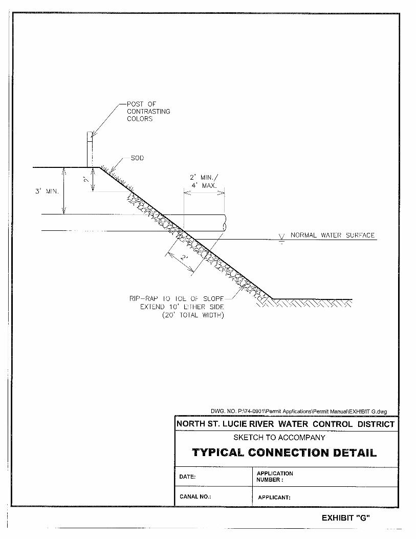
The 2.0-inch allowable discharge volume only applies to areas lying within the existing District boundaries which connect directly or indirectly to the NSLRWCD system. Applications for areas lying outside existing District boundaries will be reviewed and evaluated on a case-by-case basis. Direct or indirect connections to Five Mile Creek, Ten Mile Creek, or the North Fork of the St. Lucie River may also be subject to more stringent runoff criteria by other government entities. All gravity drainage connections to District canals shall be made in accordance with the details shown on Exhibit C. The applicant shall provide a surveyed cross-section through the canal at the location of proposed connection, demonstrating the proposed configuration within the NSLRWCD right-of-way. Design specifications (e.g., bank stabilization) may be imposed in order to prevent bank erosion. The typical drainage connection configuration is shown on Exhibit G. For drainage design purposes, the applicant may contact the District for information concerning canal tailwater elevations for use at the applicant’s own risk. The applicant is encouraged to contact the District concerning any decisions made on assumed tailwater stages in District canals prior to use of the tailwater elevation in any drainage analysis. For all drainage connections, the application submittal shall include calculations to demonstrate that the site development is in compliance with state water quality standards for the North Fork of the St. Lucie River. Additionally, for all drainage connections, the applicant shall submit calculations demonstrating that the storage volume of the water management facilities complies with the SFWMD Basis of Review (BOR) and that the project recovers to the designed control elevation within 12 days of a

North St. Lucie River Water Control District -8- Permit Information and Criteria Manual
storm event. For the use of detention and retention areas, the applicant shall include assurance that the soils can provide adequate percolation for the intended purpose. For projects involving land areas outside District boundaries which are proposed to drain through the District, special provisions may be required to comply with the water control and water quality objectives of the District. The applicant shall contact the District for a pre-application meeting to discuss the proposed project. C. Irrigation Connections Connections to District canals for irrigation withdrawals shall be designed and installed in a manner that is consistent with the water control, operation and maintenance objectives of the District. Irrigation intake works lying within the limits of the canal shall not impair the District’s ability to perform normal operations. Intake works violating this objective shall be removed immediately upon request of the District. For conforming irrigation connections, intake works shall be removed at the District’s request during maintenance operations. Above-ground irrigation system improvements including, but not limited to, pumps, pump houses or appurtenant works shall not be permitted in the District’s right-of-way. Effective February 14, 2008, all permitted water uses via pump and culvert may be considered by the Board for inclusion in the District-wide SFWMD Diversion and Impoundment permit. Well uses are required to maintain an individual SFWMD permit. For further information, contact the District office or consult the District’s website under “Water Use Information”. D. All Connections
1. The location of all connections shall be clearly marked by placing a post of contrasting colors over the culvert or pipe. The post shall be placed over the culvert or pipe at the top of the canal slope.
2. The permittee shall install and maintain connections in a manner that will prevent the introduction of hyacinths or other aquatic growth into the District’s canals.
SECTION 5 OPEN CHANNEL CONNECTIONS
Because open channel connections disrupt continuous access along canals by District maintenance equipment, open channel connections shall not be permitted. However, the District may waive this requirement, provided that a waiver will not adversely impact other lands in the District or the operation and maintenance efforts of the District.

North St. Lucie River Water Control District -9- Permit Information and Criteria Manual
SECTION 6
SPOIL DISPOSITION Earthen material (spoil) excavated from District canals and deposited on District rights-of-way is the property of the District. The District may dispose of this spoil in a manner which, in the opinion of the District, is in its best interest. This includes, but is not limited to, authorizing the adjacent landowner to use it on his adjacent property at no cost, or by selling to someone other than the adjacent landowner. A permit must be secured from the District before removing any spoil. At the discretion of the District and at the request of the property owner adjacent to the canal from which spoil is to be removed, such spoil may be taken by the landowner and used on his adjacent land. The landowner shall be responsible for repairing or restoring any damage to District facilities resulting from his removal of the spoil material. Restoration of the canal, berm and right-of-way shall be in accordance with the requirements of Exhibit D. Each application shall be evaluated and acted upon independently, depending on the needs of the District and its landowners at the time the application is considered.
SECTION 7 UTILITY CONSTRUCTION
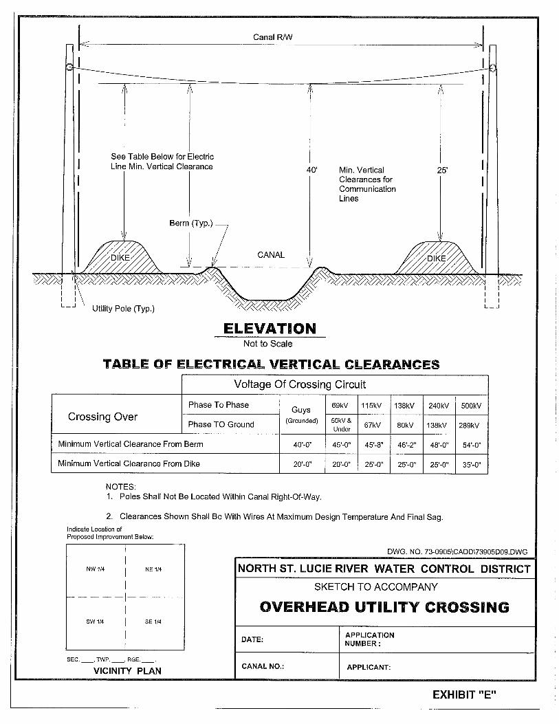
A. Aerial Crossings
1) Overhead lines shall not be permitted to cross directly over District water control structures.
2) Overhead communication and similar utility line crossings of District rights-of-ways
and Project Works shall have the following minimum vertical clearance as measured to the elevation of the lowest wire:
a) 40 feet above the elevation of the canal berm, as measured from the lowest point
of sag; or
b) 25 feet above the dike crown;
whichever produces the higher wire elevation. These facilities shall be constructed in accordance with the requirements shown on Exhibit E.
3) Overhead power lines shall have minimum vertical clearances as shown on Exhibit E.
In all cases, minimum vertical clearance shall be measured from the elevation of the lowest point of sag of the line within the District right-of-way or easement to the highest point of the berm or dike crown.

North St. Lucie River Water Control District -10- Permit Information and Criteria Manual
In all cases, surveyed elevations within the District right-of-way or easement referenced to the NGVD-29 or NAVD-88 design datum shall be provided to verify the proposed vertical clearance. B. Over-Water Crossings The design and construction of pile-supported or free-span utilities over a District canal shall be subject to the same horizontal and vertical clearance requirements specified for bridges in Section 3. If an installation is to be made adjacent to an existing bridge, pilings shall be aligned with the bridge pilings, with no intermediate pilings or bents permitted. A cross-section of the canal along the centerline of the proposed work from top-of-bank to top-of-bank, drawn to scale and referenced to NGVD-29 or NAVD-88, shall be submitted with the application. The cross-section shall be representative of the canal, maintenance berm and the ground configuration within the canal right-of-way at the proposed crossing location, and shall include sufficient points to identify each right-of-way line, canal top of bank, toe of slope, and at the lowest point of the canal bottom with spacing not greater than 10-foot increments. C. Under-Canal Crossings Under-canal utility crossings of any type including, but not limited to, communication cables and water, wastewater, or irrigation quality reuse lines, shall be installed to provide a minimum cover of four (4) feet over the utility line. This cover shall be measured from the top of the utility line’s protective encasement to the existing canal bottom, original design section or, if known, ultimate section, whichever produces the lowest installation. Directional bore installations may be acceptable, but will require a minimum cover of six (6) feet over the utility line. At a minimum, all communication and power lines shall be encased in a continuous length of seamless steel pipe, or approved equivalent, throughout the width of the canal right-of-way. A scaled drawing showing the existing cross-section of the canal and right-of-way, with elevations referenced to NGVD-29 or NAVD-88, shall be submitted with the application. Water, wastewater and similar pressurized lines transmitting non-volatile fluids or gases may be buried without encasement, at the risk of the utility owner. At a minimum, however, the transmission lines must be ductile iron pipe with restrained mechanical joints throughout the canal right-of-way. HDPE-type plastic pipe may be used for directional bore installations only. Criteria for the crossing of other types of pressurized lines including, but not limited to, natural gas and steam lines, shall be determined and applied in accordance with industry standards at the time of application evaluation.

North St. Lucie River Water Control District -11- Permit Information and Criteria Manual
Vertical and horizontal spacing with other existing or proposed installations in the project vicinity shall be clearly shown on scaled construction plans. Clearances must meet minimum requirements of the jurisdictional utility or governing agency. The under-canal crossing shall be marked by the permittee by placing permanent above-ground markers or signs over the utility at each canal right-of-way line. The markers must identify the type of utility buried and the name and contact telephone number of the utility owner. All markers must be clearly visible, and must be maintained by the permittee. See Exhibit F for details. D. Utility Paralleling Canal or Right-of-Way The District discourages the installation of any utility paralleling a canal within the canal right-of-way. If an applicant can demonstrate, to the satisfaction of the District’s Board, that refusal to allow such an installation will result in an undue hardship, then the District may consider such an application. However, the establishment of criteria and terms and conditions of such an approval, if granted, are solely within the jurisdiction of the Board, and may include an annual usage fee.
SECTION 8 OTHER USES AND REQUIREMENTS
A. Water Control Structure Installation and Operation The installation of a water control feature on a District-owned culvert for water conservation and irrigation purposes by a landowner may be allowed by the District. The District shall evaluate each application on a case by case basis for the potential impact it may have on its system to assure that such a request is consistent with the District’s objectives of water control. If such installation is found to be consistent with District objectives, then the District will enter into a separate agreement with the landowner for use of the structure. The agreement shall specify operating protocol, maintenance requirements and may include, as applicable, indemnification of the District for the operation of, and/or a surety for removal of the water control feature. Operation of District-owned water control structures is the sole responsibility of the District. However, cooperative agreements may be made with landowners or their agents for joint operation of such a structure, provided that it is consistent with the District’s objectives. The District shall maintain the right to over-ride such an agreement to fulfill its primary duty and obligation to operate the structure in whatever fashion it deems necessary to meet its objectives of water control. B. Beehives

North St. Lucie River Water Control District -12- Permit Information and Criteria Manual
The District is required by law to adopt and use methods and processes reasonably adequate to render any place of employment safe and to protect the well-being of its employees. Therefore, the placement of beehives on District rights-of-ways shall not be permitted. C. Use of Canal Berms for Access Unless deemed by the Board to be subject to the terms and limitations specified in the Board Resolution recorded on December 21, 1989 in Official Record Book 669, Page 699 of the public records of St. Lucie County, Florida, a landowner must obtain a “Permit and License for Access” from the District for the use of a District canal berm for property access. It is the policy of the District to discourage the use of District rights-of-way for public access. If granted, such access is intended for low intensity uses and shall be limited to the necessary portions of District rights-of-way sufficient to afford private property owners the quiet and peaceful use of their property. Such access is not intended for heavy traffic volumes or commercial uses. The use shall be at the sole risk of the landowner and such use of the District’s canal berms and spoil banks for property access shall not in any manner whatsoever interfere with, impede or hamper the District in the operation, maintenance, widening, or improvements of the District canals, ditches and other drainage facilities. Additionally, the District shall have no obligation to maintain its canal or spoil banks for road purposes. To obtain a permit for use of a District canal berm for access, the affected landowner must be able to demonstrate that there is no other legal, alternative access to the site. In other words, it must be an access of last resort. The permit for use and license will be reviewed on a case by case basis and may include, but not necessarily be limited to: 1) a description of the parcel served, 2) the intended use, 3) the safe level of service for the roadway, 4) an appropriate maintenance plan, and 5) an appropriate clause indemnifying the District for the intended use. Additionally, the landowner must acknowledge the primary and paramount right of the District to conduct its operation and maintenance activities related to surface water management within and upon its rights-of-way and that the maintenance activities of this District cannot be compromised in any way and are potentially detrimental to the landowner’s use of the District canal berm for property access. D. Fencing of Canal Right-of-Way The capability to move water through the District’s system of canals is essential for drainage and irrigation purposes. Anything that inhibits or diminishes this capability is contrary to District policy. The uncontrolled movement of livestock across a canal without the benefit of a culvert or bridge crossing is one way that the effectiveness of a canal can be degraded. Not only does livestock carry material into the canal from the canal bank and the berm, but the path they create accelerates erosion, aggravating an already unacceptable condition. Therefore, it is the policy of the District that the owner of any property used for raising livestock adjacent to a District canal must fence the property to control access by livestock to District canal rights-of-way.

North St. Lucie River Water Control District -13- Permit Information and Criteria Manual
No fencing by landowners shall be installed in a fashion so as to deprive the District of access to its rights-of-way for maintenance or other purposes, unless pursuant to District permit. No fencing shall be installed both parallel to, and within the District right-of-way. Fences running parallel to the District right-of-way shall be placed on the landowner’s property. In order to assure to District adequate access for maintenance adjacent to canals, all fencing by landowners adjacent to District canals shall be set back from the top of canal bank a distance equal to the dimension of the right-of-way owned by the District or 20 feet, whichever is greater. If livestock owners wish to have livestock cross a canal, it must be over a culverted or bridged crossing meeting the District’s regulations. Any fencing perpendicular to District canal right-of-way associated with livestock crossings must include provisions for gates meeting the requirements outlined in section 8.E of this manual. A permit application must be submitted by the applicant and approved by the District before the culvert may be installed. E. Gates in Canal Right-of-Way A landowner may install a gate on a canal berm, provided a permit is secured from the District and the following criteria are met:
1. The gate must be at least twelve (12) feet wide to accommodate District maintenance equipment.
2. The construction materials and methods must be coordinated with, and approved by, the District’s Superintendent of Works.
3. The landowner must purchase a padlock from the District and interlock his padlock with the District’s padlock.
P:\74-0901\Permit Application Documentation\Permit Manual\Rules Rev 03-25-2010.doc