Embed Size (px)
Citation preview
Northwest Area Committee
________________________________________________________________
NORTH OREGON COAST
GEOGRAPHIC RESPONSE PLAN (GRP)
PACIFICOCEAN
AREA OF COVERAGE


Spill Response Contact Sheet Required Notifications For Hazardous Substance Or Oil Spills
USCG National Response Center (800) 424-8802 In Oregon:
Department of Emergency Management (800) 452-0311 (800) OILS-911
In Washington: Emergency Management Division (800) 258-5990 Department of Ecology (360) 753-2353
U.S. Coast Guard National Response Center (800)-424-8802 Marine Safety Office Puget Sound:
Watchstander (206) 217-6232 Safety Office (206) 217-6232
Marine Safety Office Portland Watchstander (503) 240-9301 Port Operations (503) 240-9379
Pacific Strike Team (415) 883-3311 District 13: MEP/drat (206) 220-7210 Command Center (206) 220-7021 Safety Officer (206) 220-7242 Public Affairs (206) 220-7235 Vessel Traffic Service (VTS) (206) 217-6050
Environmental Protection Agency (EPA) Region 10 Spill Response (206)-553-1263 Washington Ops Office (206) 753-9083 Oregon Ops Office (503) 326-3250 Idaho Ops Office (208) 334-1450 RCRA/CERCLA Hotline (800) 424-9346 Public Affairs (206) 553-1203 National Oceanic Atmosphere Administration Scientific Support Coordination (206) 526-6829 Weather (206) 526-6087 Canadian Marine Emergency Ops (604) 666-6011 Environmental Protection (604) 666-6100 B.C. Environment (604) 356-7721 Department Of Interior Environmental Affairs (503) 231-6157 U.S. Navy Naval Shipyard (206) 476-3466 Naval Base Seattle (206) 526-3225 Supervisor of Salvage (202) 695-0231 Army Corps Of Engineers Hazards to Navigation (206) 764-3754
Response Contractors Fred Devine (503) 283-5285 Global Diving (206) 623-0621 NRC Environmental (503) 283-1150 US Environmental (866) 876-7745 Washington State Department of Ecology:
Headquarters (206) 407-6900 SW Regional (206) 753-2353 NW Regional (206) 649-7000 Central Regional (509) 575-2490 Eastern Regional (509) 456-2926
Department of Emergency Management (206) 438-8639 (800) 258-5990 State Patrol (206) 753-6856 Oregon State Department of Environmental Quality Headquarters (Portland) (503) 229-5153 Northwest Region (Portland) (503) 229-5263 Eastern Region (Bend) (541) 338-6146 Eastern Region (Pendleton) (541) 278-4063 Western Region (Coos Bay) (541) 269-2721 Western Region (Eugene) (541) 686-7838 Western Region (Medford) (541) 776-6010 Western Region (Salem) (503) 378-8240 Emergency Management (503) 378-6377 (In state) (800) 452-0311 (In state) (800) OILS911 Stop Oregon Litter & Vandalism (503) 647-9855 Boldface type are 24-hour numbers
North Oregon Coast Geographic Response Plan
1 December 2004 Change 4
2
This Page Left Blank

North Oregon Coast Geographic Response Plan
1 December 2004 Change 4
3
HOW TO USE THIS GEOGRAPHIC RESPONSE PLAN
Purpose of Geographic Response Plan (GRP) This plan prioritizes resources to be protected and allows for immediate and proper action. By using this plan, the first responders to a spill can avoid the initial confusion that generally accompanies any spill. Geographic Response Plans are used during the emergent phase of a spill which lasts from the time a spill occurs until the Unified Command is operating and/or the spill has been contained and cleaned up. Generally this last no more than 24 hours. The GRPs constitute the federal on-scene coordinators’ and state on-scene coordinators’ “orders” during the emergent phase of the spill. During the project phase the GRP will continue to be used, but with input from natural resource trustees. Strategy Selection Chapter 4.1 of the GRP contains complete strategy descriptions in matrix form and response priorities. The accompanying maps are located in Chapter 4.2. The strategies depicted in Chapter 4.2 will be implemented after reviewing on scene information including: tides, currents, weather conditions, oil type, initial trajectories, etc. It is important to note that strategies rely on the trajectory of the spill. A booming strategy listed as a high priority would not necessarily be implemented if the spill trajectory and location did not warrant action in that area. Chapter 6 outlines the sensitive resources requiring protection and the seasonality of their sensitivity. This information must be consulted before strategies are implemented as there may be flight restrictions associated with a resource. Flight restriction information is also found in chapter 6. Standardized Response Language In order to avoid confusion in response terminology, this GRP uses strategy names defined in Appendix A (e.g. diversion booming, exclusion booming). Response Equipment A table outlining equipment availability and response times is being developed for this geographic response plan. In the interim, strategies will be deployed in the order equipment arrives on scene and as directed/selected by the on-scene coordinator.

North Oregon Coast Geographic Response Plan
4 1 December 2004 Change 4
This Page Left Blank

North Oregon Coast Geographic Response Plan
5 1 December 2004 Change 4
Record of Changes
Date Change Number Summary of Changes
1 August 1995 Original Release
1 February 1997 1 Editing. Added maps and text to chapters five & six.
1 October 1997 2 Editing. Corrected a chapter five map. Added text to chapter six.
1 June 2000 3 Revised, renumbered, and added lat/lon to Chapter 4 strategies. Added Section 6.9, Aquaculture.
1 December 2004 4 Deleted “GRPs only address protection of sensitive public resources. Updated contact sheet.
North Oregon Coast Geographic Response Plan
1 August 1997 6
This Page Left Blank
North Oregon Coast Geographic Response Plan
1 August 1997 7
North Oregon Coast Geographic Response Plan
Table of Contents
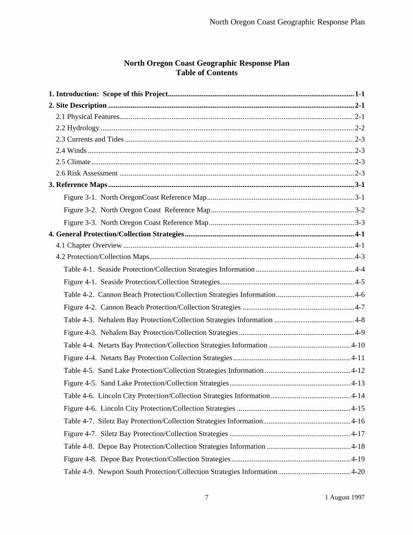
1. Introduction: Scope of this Project....................................................................................................1-1 2. Site Description ....................................................................................................................................2-1
2.1 Physical Features..............................................................................................................................2-1 2.2 Hydrology ........................................................................................................................................2-2 2.3 Currents and Tides ...........................................................................................................................2-3 2.4 Winds ...............................................................................................................................................2-3 2.5 Climate .............................................................................................................................................2-3 2.6 Risk Assessment ..............................................................................................................................2-3
3. Reference Maps....................................................................................................................................3-1
Figure 3-1. North OregonCoast Reference Map...............................................................................3-1
Figure 3-2. North Oregon Coast Reference Map.............................................................................3-2
Figure 3-3. North Oregon Coast Reference Map..............................................................................3-3 4. General Protection/Collection Strategies...........................................................................................4-1
4.1 Chapter Overview ............................................................................................................................4-1 4.2 Protection/Collection Maps..............................................................................................................4-3
Table 4-1. Seaside Protection/Collection Strategies Information .....................................................4-4
Figure 4-1. Seaside Protection/Collection Strategies........................................................................4-5
Table 4-2. Cannon Beach Protection/Collection Strategies Information..........................................4-6
Figure 4-2. Cannon Beach Protection/Collection Strategies ............................................................4-7
Table 4-3. Nehalem Bay Protection/Collection Strategies Information ...........................................4-8
Figure 4-3. Nehalem Bay Protection/Collection Strategies ..............................................................4-9
Table 4-4. Netarts Bay Protection/Collection Strategies Information ............................................4-10
Figure 4-4. Netarts Bay Protection Collection Strategies ...............................................................4-11
Table 4-5. Sand Lake Protection/Collection Strategies Information ..............................................4-12
Figure 4-5. Sand Lake Protection/Collection Strategies.................................................................4-13
Table 4-6. Lincoln City Protection/Collection Strategies Information...........................................4-14
Figure 4-6. Lincoln City Protection/Collection Strategies .............................................................4-15
Table 4-7. Siletz Bay Protection/Collection Strategies Information...............................................4-16
Figure 4-7. Siletz Bay Protection/Collection Strategies .................................................................4-17
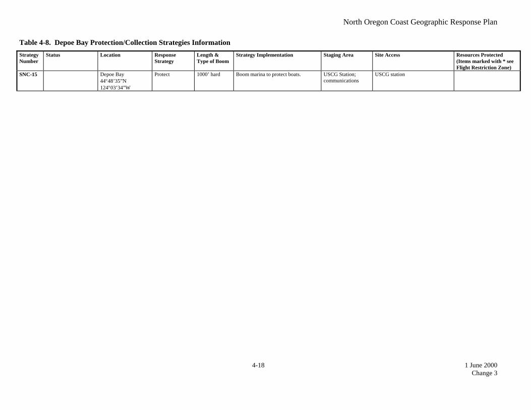
Table 4-8. Depoe Bay Protection/Collection Strategies Information .............................................4-18
Figure 4-8. Depoe Bay Protection/Collection Strategies ................................................................4-19
Table 4-9. Newport South Protection/Collection Strategies Information.......................................4-20

North Oregon Coast Geographic Response Plan
1 August 1997 8
Figure 4-9. Newport South Protection/Collection Strategies..........................................................4-21
Table 4-10. Ona Beach Protection/Collection Strategies Information............................................4-22
Figure 4-10. Ona Beach Protection/Collection Strategies ..............................................................4-23
Table 4-11. Waldport Protection/Collection Strategies Information ...............................................4-24
Figure 4-11. Waldport Protection/Collection Strategies.................................................................4-25 4.3 Protection/Collection Priorities for North Coast Scenarios ...........................................................4-26
Table 4-1. Oil spilled at the entrance to Depoe Bay, Incoming tide. (Scenario 1) ..........................4-26
Table 4-2. Oil moving toward Siletz Bay, Incoming tide. (Scenario 2) .........................................4-26 5. Shoreline Countermeasures ................................................................................................................5-1
5.1 Chapter Overview ............................................................................................................................5-1 5.2 Shoreline Type Maps .......................................................................................................................5-1 5.3 Oil Countermeasure Matrix: ............................................................................................................5-1
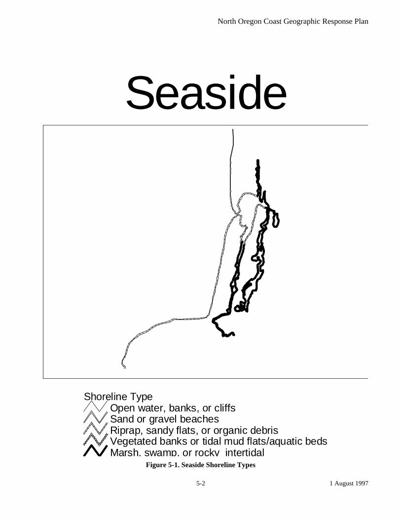
Figure 5-1. Seaside Shoreline Types .................................................................................................5-2
Figure 5-2. Cannon Beach Shoreline Types ......................................................................................5-3
Figure 5-3. Nehalem Bay Shoreline Types........................................................................................5-4
Figure 5-4. Netarts Bay Shoreline Types..........................................................................................5-5
Figure 5-5. Sand Lake Shoreline Types............................................................................................5-6
Figure 5-6. Lincoln City Shoreline Types ........................................................................................5-7
Figure 5-7. Siletz Bay Shoreline Types ............................................................................................5-8
Figure 5-8. Depoe Bay Shoreline Types...........................................................................................5-9
Figure 5-9. Newport South Shoreline Types ..................................................................................5-10
Figure 5-10. Ona Beach Shoreline Types .......................................................................................5-11
Figure 5-11. Waldport Shoreline Types .........................................................................................5-12 6. Wildlife Resource/Flight Restriction Information ............................................................................6-1
6.1 Chapter Overview ............................................................................................................................6-1 6.2 Fisheries ...........................................................................................................................................6-1 6.3 Wildlife ............................................................................................................................................6-1 6.4 Marine Mammals .............................................................................................................................6-1 6.5 Shorebirds, Waterfowl, and Raptors ................................................................................................6-1 6.6 Archeological Sites ..........................................................................................................................6-1 6.7 Wildlife Maps ..................................................................................................................................6-2 6.8 Wildlife Resource/Flight Restriction Tables....................................................................................6-2 6.9 Wildlife Maps ..................................................................................................................................6-3
Table 6-1 Wildlife Resource/Flight Restriction Table.......................................................................6-4
Figure 6-1. Seaside Wildlife .............................................................................................................6-5
Figure 6-2. Nehalem Bay Wildlife....................................................................................................6-6
North Oregon Coast Geographic Response Plan
1 August 1997 9
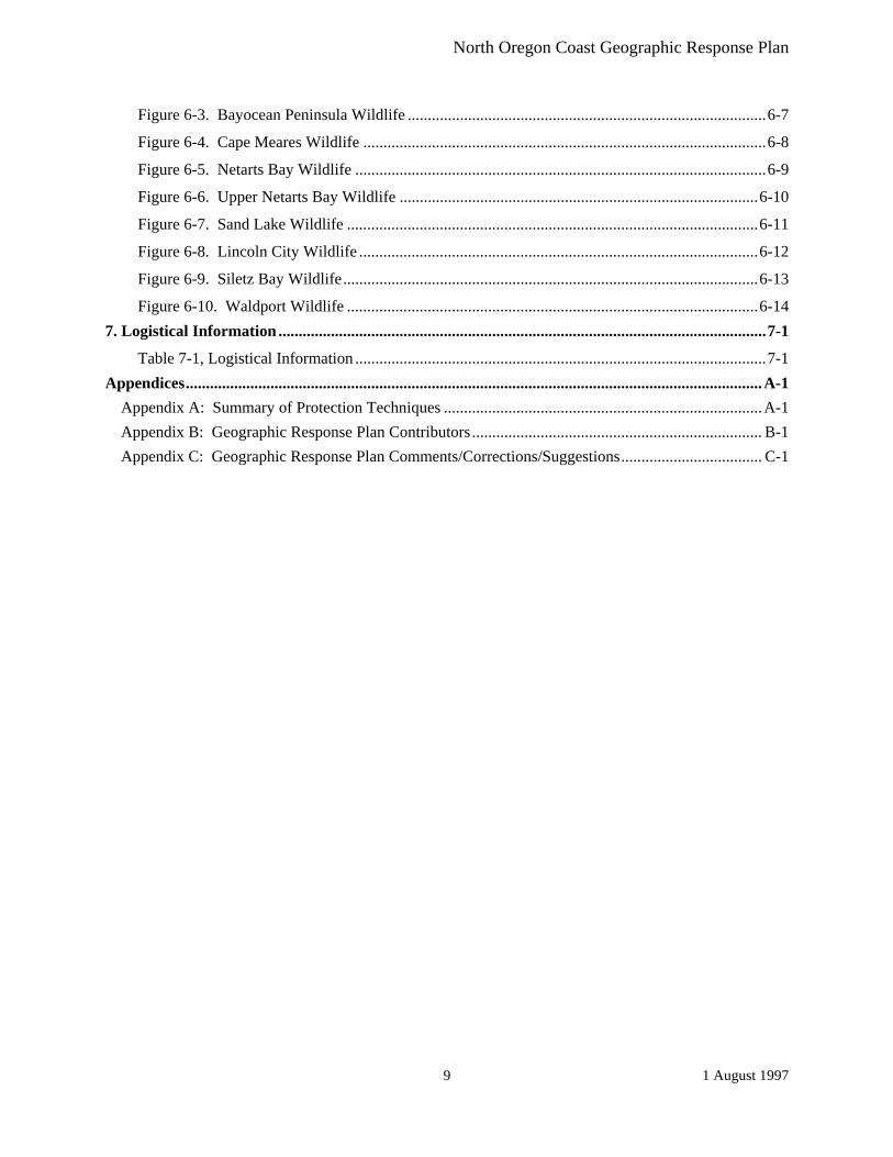
Figure 6-3. Bayocean Peninsula Wildlife .........................................................................................6-7
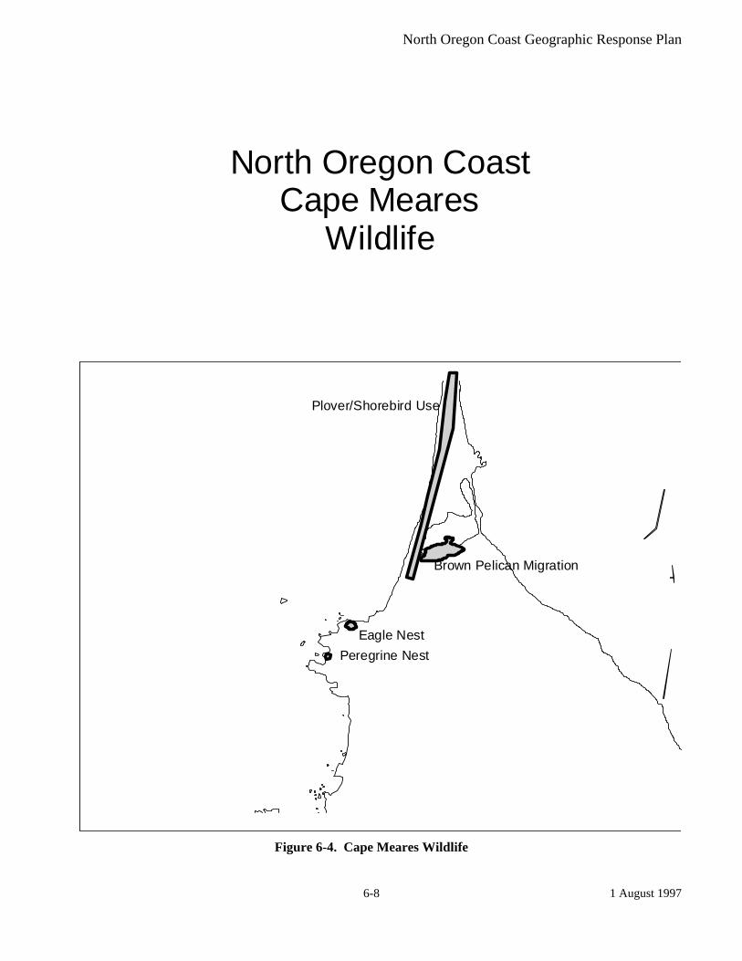
Figure 6-4. Cape Meares Wildlife ....................................................................................................6-8
Figure 6-5. Netarts Bay Wildlife ......................................................................................................6-9
Figure 6-6. Upper Netarts Bay Wildlife .........................................................................................6-10
Figure 6-7. Sand Lake Wildlife ......................................................................................................6-11
Figure 6-8. Lincoln City Wildlife ...................................................................................................6-12
Figure 6-9. Siletz Bay Wildlife.......................................................................................................6-13
Figure 6-10. Waldport Wildlife ......................................................................................................6-14 7. Logistical Information .........................................................................................................................7-1
Table 7-1, Logistical Information ......................................................................................................7-1 Appendices...............................................................................................................................................A-1
Appendix A: Summary of Protection Techniques ...............................................................................A-1 Appendix B: Geographic Response Plan Contributors ........................................................................ B-1 Appendix C: Geographic Response Plan Comments/Corrections/Suggestions................................... C-1

North Oregon Coast Geographic Response Plan
1 August 1997 10
North Oregon Coast Geographic Response Plan Table of Figures
Figure 3-1. North OregonCoast Reference Map ..................................................................................3-1
Figure 3-2. North Oregon Coast Reference Map ................................................................................3-2
Figure 3-3. North Oregon Coast Reference Map .................................................................................3-3
Figure 4-1. Seaside Protection/Collection Strategies ...........................................................................4-5
Figure 4-2. Cannon Beach Protection/Collection Strategies ...............................................................4-7
Figure 4-3. Nehalem Bay Protection/Collection Strategies .................................................................4-9
Figure 4-4. Netarts Bay Protection Collection Strategies..................................................................4-11
Figure 4-5. Sand Lake Protection/Collection Strategies....................................................................4-13
Figure 4-6. Lincoln City Protection/Collection Strategies.................................................................4-15
Figure 4-7. Siletz Bay Protection/Collection Strategies .....................................................................4-17
Figure 4-8. Depoe Bay Protection/Collection Strategies....................................................................4-19
Figure 4-9. Newport South Protection/Collection Strategies ............................................................4-21
Figure 4-10. Ona Beach Protection/Collection Strategies .................................................................4-23
Figure 4-11. Waldport Protection/Collection Strategies ...................................................................4-25
Figure 5-1. Seaside Shoreline Types.......................................................................................................5-2
Figure 5-2. Cannon Beach Shoreline Types...........................................................................................5-3
Figure 5-3. Nehalem Bay Shoreline Types.............................................................................................5-4
Figure 5-4. Netarts Bay Shoreline Types ..............................................................................................5-5
Figure 5-5. Sand Lake Shoreline Types ................................................................................................5-6
Figure 5-6. Lincoln City Shoreline Types .............................................................................................5-7
Figure 5-7. Siletz Bay Shoreline Types..................................................................................................5-8
Figure 5-8. Depoe Bay Shoreline Types ................................................................................................5-9
Figure 5-9. Newport South Shoreline Types.......................................................................................5-10
Figure 5-10. Ona Beach Shoreline Types............................................................................................5-11
Figure 5-11. Waldport Shoreline Types..............................................................................................5-12
Figure 6-1. Seaside Wildlife ...................................................................................................................6-5
Figure 6-2. Nehalem Bay Wildlife .........................................................................................................6-6
Figure 6-3. Bayocean Peninsula Wildlife ..............................................................................................6-7
Figure 6-4. Cape Meares Wildlife..........................................................................................................6-8
Figure 6-5. Netarts Bay Wildlife............................................................................................................6-9
Figure 6-6. Upper Netarts Bay Wildlife ..............................................................................................6-10

North Oregon Coast Geographic Response Plan
1 August 1997 11
Figure 6-7. Sand Lake Wildlife............................................................................................................6-11
Figure 6-8. Lincoln City Wildlife.........................................................................................................6-12
Figure 6-9. Siletz Bay Wildlife .............................................................................................................6-13
Figure 6-10. Waldport Wildlife ...........................................................................................................6-14

North Oregon Coast Geographic Response Plan
1 August 1997 12
This Page Left Blank

North Oregon Coast Geographic Response Plan
1 August 1997 1-1
North Coast, Oregon
GEOGRAPHIC RESPONSE PLAN 1. Introduction: Scope of this Project Geographic Response Plans are intended to help the first responders to a spill avoid the initial confusion that generally accompanies any spill. They prioritize resources to be protected and allow for immediate and proper action. GRPs are developed for marine waters of Washington and Oregon State, the Columbia River, and the inland areas of Washington, Oregon and Idaho. They are prepared through the efforts of the Washington Department of Ecology, Oregon Department of Environmental Quality, Idaho State Emergency Response Commission, the U.S. Coast Guard, and the Environmental Protection Agency. GRPs are developed through workshops involving federal, state, and local oil spill emergency response experts, representatives from tribes, industry, ports, environmental organizations, pilots and response contractors. Workshop participants identify resources which require protection, develop operational strategies, and pinpoint logistical support. The first goal of a GRP is to identify resources, physical features, hydrology, currents and tides, and winds and climate that may affect response strategies. After compiling this information, sensitive resources are identified. Secondly, response strategies are developed based on the sensitive resources noted, hydrology, and climatic considerations. Individual response strategies identify the amount and type of equipment necessary for implementation. The response strategies are then applied to likely spill scenarios for oil movement, taking into account factors such as wind and tidal conditions. Finally, additional logistical support is identified, including: Location of the operations center for the central response organization; Local equipment and trained personnel; Local facilities and services and appropriate contacts for each; Response times for bringing equipment in from other areas. By using this plan as a guideline, the first responders to a spill can avoid the initial confusion that generally accompanies any spill. This plan prioritizes resources to be protected and allows for immediate and proper action.

North Oregon Coast Geographic Response Plan
1 August 1997 1-2
This Page Left Blank
North Oregon Coast Geographic Response Plan
1 August 1997 2-1
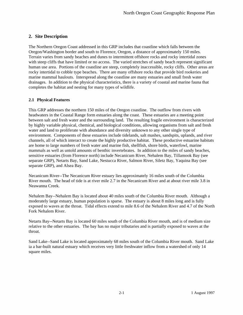
2. Site Description The Northern Oregon Coast addressed in this GRP includes that coastline which falls between the Oregon/Washington border and south to Florence, Oregon, a distance of approximately 150 miles. Terrain varies from sandy beaches and dunes to intermittent offshore rocks and rocky intertidal zones with steep cliffs that have limited or no access. The varied stretches of sandy beach represent significant human use area. Portions of the coastline are steep, completely inaccessible, rocky cliffs. Other areas are rocky intertidal to cobble type beaches. There are many offshore rocks that provide bird rookeries and marine mammal haulouts. Interspread along the coastline are many estuaries and small fresh water drainages. In addition to the physical characteristics, there is a variety of coastal and marine fauna that completes the habitat and nesting for many types of wildlife.
2.1 Physical Features This GRP addresses the northern 150 miles of the Oregon coastline. The outflow from rivers with headwaters in the Coastal Range form estuaries along the coast. These estuaries are a meeting point between salt and fresh water and the surrounding land. The resulting fragile environment is characterized by highly variable physical, chemical, and biological conditions, allowing organisms from salt and fresh water and land to proliferate with abundance and diversity unknown to any other single type of environment. Components of these estuaries include tidelands, salt mashes, sandspits, uplands, and river channels, all of which interact to create the highly productive habitat. These productive estuarine habitats are home to large numbers of fresh water and marine fish, shellfish, shore birds, waterfowl, marine mammals as well as untold amounts of benthic invertebrates. In addition to the miles of sandy beaches, sensitive estuaries (from Florence north) include Necanicum River, Nehalem Bay, Tillamook Bay (see separate GRP), Netarts Bay, Sand Lake, Nestucca River, Salmon River, Siletz Bay, Yaquina Bay (see separate GRP), and Alsea Bay. Necanicum River--The Necanicum River estuary lies approximately 16 miles south of the Columbia River mouth. The head of tide is at river mile 2.7 in the Necanicum River and at about river mile 3.8 in Neawanna Creek. Nehalem Bay--Nehalem Bay is located about 40 miles south of the Columbia River mouth. Although a moderately large estuary, human population is sparse. The estuary is about 8 miles long and is fully exposed to waves at the throat. Tidal effects extend to mile 8.6 of the Nehalem River and 4.7 of the North Fork Nehalem River. Netarts Bay--Netarts Bay is located 60 miles south of the Columbia River mouth, and is of medium size relative to the other estuaries. The bay has no major tributaries and is partially exposed to waves at the throat. Sand Lake--Sand Lake is located approximately 68 miles south of the Columbia River mouth. Sand Lake ia a bar-built natural estuary which receives very little freshwater inflow from a watershed of only 14 square miles.

North Oregon Coast Geographic Response Plan
1 August 1997 2-2
Nestucca Bay--Nestucca Bay lies approximately 75 miles south of the Columbia River mouth. Major tributaries are the Nestucca River from the north and the Little Nestucca River from the South. The bay is fully exposed to waves at the throat and head of tide extends to river mile 7 at the Nestucca River and river mile 2.3 on the Little Nestucca River. Salmon River--Salmon River estuary lies 85 miles south of the Columbia River mouth. The estuary is essentially part of the lower reaches of the Salmon River, and the bay is partially exposed to waves at the throat. Siletz Bay--Siletz Bay is roughly 95 miles south of the Columbia River Mouth. The major tributary of the Bay is the Siletz River, with the head of tide at river mile 24. Alsea Bay--Alsea Bay lies approximately 130 miles south of the Columbia River's mouth. The bay is fully exposed to waves at the throat and the head of tide is at mile 16 of the Alsea River and mile 5.5 of Drift Creek.
2.2 Hydrology The rivers meeting the ocean drain the north coast and mid-coast drainage Basins. Depending upon their outflow, they create either a Two Layered, Partially Mixed, or Well Mixed Estuary. The estuaries and their types are as follows: Partially Mixed or Two Layered, depending upon outflow: Necanicum River Nestucca River Yaquina Bay Nehalem Bay Salmon River Alsea Bay Tillamook Bay Siletz Bay Well Mixed: Netarts Bay Sand Lake Additionally, Netarts Bay and Sand Lake are the only bar built estuaries in this section of the coast. The remaining estuaries are all drowned river valleys.
North Oregon Coast Geographic Response Plan
1 August 1997 2-3
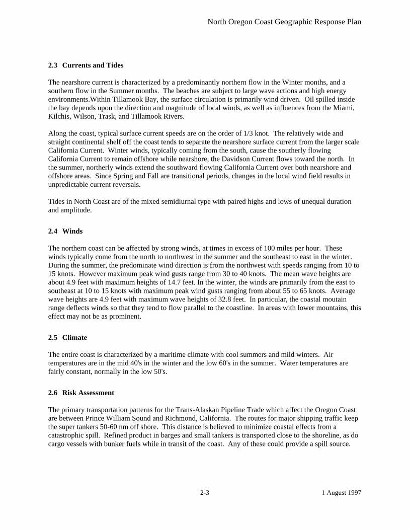
2.3 Currents and Tides The nearshore current is characterized by a predominantly northern flow in the Winter months, and a southern flow in the Summer months. The beaches are subject to large wave actions and high energy environments.Within Tillamook Bay, the surface circulation is primarily wind driven. Oil spilled inside the bay depends upon the direction and magnitude of local winds, as well as influences from the Miami, Kilchis, Wilson, Trask, and Tillamook Rivers. Along the coast, typical surface current speeds are on the order of 1/3 knot. The relatively wide and straight continental shelf off the coast tends to separate the nearshore surface current from the larger scale California Current. Winter winds, typically coming from the south, cause the southerly flowing California Current to remain offshore while nearshore, the Davidson Current flows toward the north. In the summer, northerly winds extend the southward flowing California Current over both nearshore and offshore areas. Since Spring and Fall are transitional periods, changes in the local wind field results in unpredictable current reversals. Tides in North Coast are of the mixed semidiurnal type with paired highs and lows of unequal duration and amplitude.
2.4 Winds The northern coast can be affected by strong winds, at times in excess of 100 miles per hour. These winds typically come from the north to northwest in the summer and the southeast to east in the winter. During the summer, the predominate wind direction is from the northwest with speeds ranging from 10 to 15 knots. However maximum peak wind gusts range from 30 to 40 knots. The mean wave heights are about 4.9 feet with maximum heights of 14.7 feet. In the winter, the winds are primarily from the east to southeast at 10 to 15 knots with maximum peak wind gusts ranging from about 55 to 65 knots. Average wave heights are 4.9 feet with maximum wave heights of 32.8 feet. In particular, the coastal moutain range deflects winds so that they tend to flow parallel to the coastline. In areas with lower mountains, this effect may not be as prominent.
2.5 Climate The entire coast is characterized by a maritime climate with cool summers and mild winters. Air temperatures are in the mid 40's in the winter and the low 60's in the summer. Water temperatures are fairly constant, normally in the low 50's.
2.6 Risk Assessment The primary transportation patterns for the Trans-Alaskan Pipeline Trade which affect the Oregon Coast are between Prince William Sound and Richmond, California. The routes for major shipping traffic keep the super tankers 50-60 nm off shore. This distance is believed to minimize coastal effects from a catastrophic spill. Refined product in barges and small tankers is transported close to the shoreline, as do cargo vessels with bunker fuels while in transit of the coast. Any of these could provide a spill source.

North Oregon Coast Geographic Response Plan
1 August 1997 2-4
This Page Left Blank
North Oregon Coast Geographic Response Plan
1 August 1997 3-1
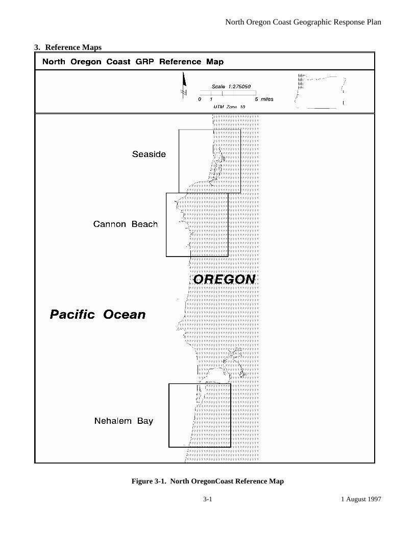
3. Reference Maps
Figure 3-1. North OregonCoast Reference Map
North Oregon Coast Geographic Response Plan
1 August 1997 3-2
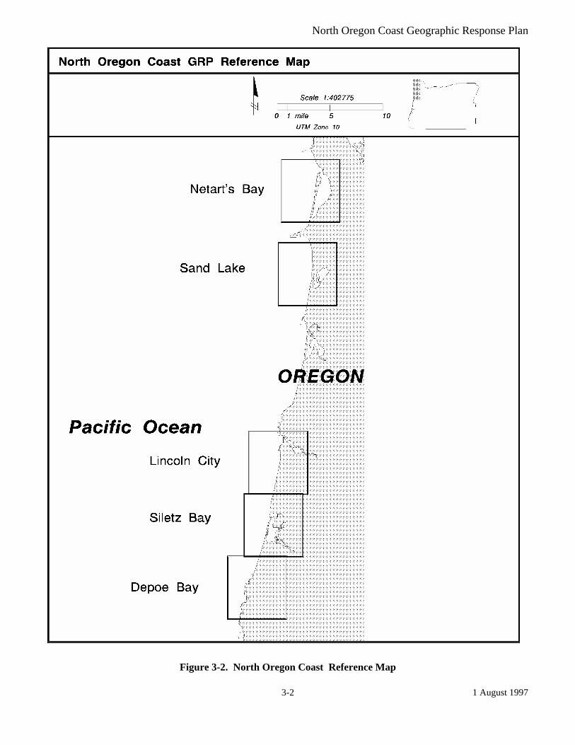
Figure 3-2. North Oregon Coast Reference Map

North Oregon Coast Geographic Response Plan
1 August 1997 3-3
Figure 3-3. North Oregon Coast Reference Map

North Oregon Coast Geographic Response Plan
1 August 1997 3-4
This Page Left Blank

North Oregon Coast Geographic Response Plan
1 August 1997 4-1
4. General Protection/Collection Strategies
4.1 Chapter Overview Control and containment It is implied that control and containment at the source is the number one priority of any response. If in the responders’ best judgment this is not feasible then the priorities laid out in the priority matrices take precedence over containment and control. This chapter details the specific response strategies and resources to protect as outlined by the participants of the GRP workshops for each Geographical Response Area. It describes, amongst other things, the strategies determined for each area. Other pertinent information necessary for proper implementation of scenarios is found in chapters five and six. This information includes shoreline types, wildlife areas, economic areas, sensitive marine areas, archeological sites, and flight restriction zones which may be implemented by the OSC if necessary. Sectors Each geographic region is divided into smaller sectors as shown by the reference map in chapter three. Maps The maps in this chapter provide information on the specific location of strategy points. They are designed to help the responder visualize response strategies in relation to valuable wildlife and archeological locations, economic areas, and sensitive marine areas. Maps are grouped in their respective subject matter areas. The maps that are being developed will be added as they are completed and placed in their respective subject matter areas. For a complete list of all maps contained in this GRP refer to the Table of Figures on page 10. • Protection/Collection maps provide information on the specific location of strategy points. These
maps are designed to help the responder visualize response strategies in relation to valuable wildlife and archeological locations, economic areas, and sensitive marine areas.
Tables This chapter contains tables which are placed in their respective subject matter areas. Some of the tables are incomplete and will be updated. • Scenario Response Priority Strategies detail the order in which strategies will be implemented
based on various local scenarios. • Response Strategy Table describes amongst other things, the details of the response strategies,
indicates the purpose of the strategy and lists special considerations that may be needed to carry out the strategies.

North Oregon Coast Geographic Response Plan
1 August 1997 4-2
Major Protection Techniques All response strategies fall into one of three major techniques that may be utilized either individually or in combination. The strategies listed in 4-2 are based on one or more of the following techniques: Dispersants: Chemicals can be used to break up slicks on the water. Dispersants can decrease the severity of a spill by speeding the dissipation of certain oil types. Their use will require approval of the Unified Command. Dispersants will only be used in offshore situations under certain conditions, until further determinations are made by the Area Committee and published in the Area Contingency Plan. In Situ Burning: If possible, an oil slick may be set on fire. Burning must be authorized by the Unified Command, who confer with state and local air and water quality authorities. This option is often preferable to allowing a slick to reach the shore. This method works on many types of oil, and requires special equipment including a fire boom and ignitors. In Situ Burning will only be allowed when consistent with the Northwest Area Contingency Plan’s In-Situ Burning Policy and Guidelines. Mechanical Recovery Strategies: If a spill is too close to the shore to use In Situ burning or dispersants, the key strategies are to use collection, diversion, or exclusion booming to contain the slick and prevent it from entering areas with sensitive wildlife and fisheries resources. This will be attempted through the use of various booming strategies. These options are described in detail in Appendix A.
North Oregon Coast Geographic Response Plan
1 August 1997 4-3
4.2 Protection/Collection Maps
North Oregon Coast Geographic Response Plan
1 June 2000 Change 3
4-4
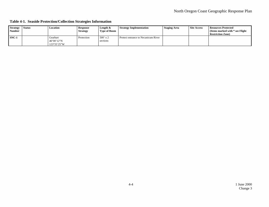
Table 4-1. Seaside Protection/Collection Strategies Information Strategy Number
Status Location Response Strategy
Length & Type of Boom
Strategy Implementation Staging Area Site Access Resources Protected (Items marked with * see Flight Restriction Zone)
SNC-1 Gearhart 46°00’12”N 123°55’25”W
Protection 500’ x 2 sections
Protect entrance to Necanicum River

North Oregon Coast Geographic Response Plan
1 June 2000 Change 3
4-5
4.2.1 Seaside
US
Hw
y 101
Gearhart
Seaside
SNC-1
RiversRoadsProtection Strategy
NNorth Coast GRP
Scale 1:50,000
0 0.5 1 1.5 2 Miles
Seaside Protection/Collection Strategies
Figure 4-1. Seaside Protection/Collection Strategies

North Oregon Coast Geographic Response Plan
1 June 2000 Change 3
4-6
Table 4-2. Cannon Beach Protection/Collection Strategies Information Strategy Number
Status Location Response Strategy
Length & Type of Boom
Strategy Implementation Staging Area Site Access Resources Protected (Items marked with * see Flight Restriction Zone)
SNC-2 Cannon B each 45°54’04”N 123°57’39”W
Deflection to collection
300’ Use deflective booming to protect Ecola Creek and recover oil

North Oregon Coast Geographic Response Plan
1 June 2000 Change 3
4-7
4.2.2 Cannon Beach
USHwy 101
Cannon Beach
Ecola Creek
SNC-2
RiversRoadsProtection Strategy
NNorth Coast GRP
Scale 1:50,000
0 0.5 1 1.5 2 Miles
Cannon Beach Protection/Collection Strategies
Figure 4-2. Cannon Beach Protection/Collection Strategies

North Oregon Coast Geographic Response Plan
1 June 2000 Change 3
4-8
Table 4-3. Nehalem Bay Protection/Collection Strategies Information Strategy Number
Status Location Response Strategy
Length & Type of Boom
Strategy Implementation Staging Area Site Access Resources Protected (Items marked with * see Flight Restriction Zone)
SNC-3
Mouth of Nehalem Bay 45°39’22”N 123°56’36”W
Deflection 500’ x 2 sections
If possible, attach boom to entrance buoy to direct oil away from mouth of Nehalem Bay
Need large boats to attach and tend boom
SNC-4 Nehalem North Spit 45°39’37”N 123°55’53”W
Collection 1000’ x 4 sections
Use 4 sections (1000’) of boom to collect oil on flood tide
Very poor access on west side

North Oregon Coast Geographic Response Plan
1 June 2000 Change 3
4-9
4.2.3 Nehalem Bay
Neh
alem
Ba y
USHw
y 101
SNC-4
SNC-3
RiversRoadsProtection Strategy
NNorth Coast GRP
Scale 1:50,000
0 0.5 1 1.5 2 Miles
Nehalem Bay Protection/Collection Strategies
Figure 4-3. Nehalem Bay Protection/Collection Strategies

North Oregon Coast Geographic Response Plan
1 June 2000 Change 3
4-10
Table 4-4. Netarts Bay Protection/Collection Strategies Information Strategy Number
Status Location Response Strategy
Length & Type of Boom
Strategy Implementation Staging Area Site Access Resources Protected (Items marked with * see Flight Restriction Zone)
SNC-5 Entrance to Netarts 45°26’04”N 123°57’05”W
Protection 1000’ x 4 sections
Protect entrance to Netarts using cascading booming
SNC-6 Netarts 45°24’52”N 123°56’00”W
Protection 1000’ Protect mouths of various small streams

North Oregon Coast Geographic Response Plan
1 June 2000 Change 3
4-11
4.2.4 Netarts Bay
Netarts Bay
Netarts Highway
Whis
key
Cr e
ek R
oad
Netarts Highw
SNC-5
SNC-6
SNC-6
SNC-6
SNC-6
SNC-6
SNC-5SNC-5
SNC-5
SNC-5
RiversRoadsProtection Strategy
NNorth Coast GRP
Scale 1:50,000
0 0.5 1 1.5 2 Miles
Netarts Bay Protection/Collection Strategies
Figure 4-4. Netarts Bay Protection Collection Strategies

North Oregon Coast Geographic Response Plan
1 June 2000 Change 3
4-12
Table 4-5. Sand Lake Protection/Collection Strategies Information Strategy Number
Status Location Response Strategy
Length & Type of Boom
Strategy Implementation Staging Area Site Access Resources Protected (Items marked with * see Flight Restriction Zone)
SNC-7 Sand Lake 45°16’25”N 123°56’44”W
Protect 1000’ hard Boom off entrances to various small creek tributaries
SNC-8 Sand Lake 45°16’48”N 123°57’09”W
Deflection to Collection
300’ x 2 sections
Deflect oil and collect near Sand Beach Campground
Sand Beach Campground

North Oregon Coast Geographic Response Plan
1 June 2000 Change 3
4-13
4.2.5 Sand Lake
San
d La
ke R
oad
Sand Lake
SNC-7
SNC-7
SNC-8
SNC-7
SNC-8
SNC-8
SNC-8
SNC-7
RiversRoadsProtection Strategy
NNorth Coast GRP
Scale 1:50,000
0 0.5 1 1.5 2 Miles
Sand Lake Protection/Collection Strategies
Figure 4-5. Sand Lake Protection/Collection Strategies

North Oregon Coast Geographic Response Plan
1 June 2000 Change 3
4-14
Table 4-6. Lincoln City Protection/Collection Strategies Information Strategy Number
Status Location Response Strategy
Length & Type of Boom
Strategy Implementation Staging Area Site Access Resources Protected (Items marked with * see Flight Restriction Zone)
SNC-9 Neskowin 45°02’49”N 124°00’04”W
Deflection to collection
600’ x 2 sections
Use deflective booming to protect Salmon River at entrance and recover oil
SNC-10 Neskowin 45°02’26”N 123°59’41”W
Deflection to collection
1200’ (use marsh boom if available)
Major tidal flat, try boom to collect, or protect
SNC-11 Lincoln City 45°58’06”N 124°01’00”W
Protection 400’ Protect Devil’s lake at entrance.

North Oregon Coast Geographic Response Plan
1 June 2000 Change 3
4-15
4.2.6 Lincoln City
SNC-9
SNC-9
SNC-10
Tillamook County
Lincoln County
Cascade Head
State Highway 18
Lincoln City
SNC-11
US Highway 1
01
RiversRoadsProtection Strategy
NNorth Coast GRP
Scale 1:50,000
0 0.5 1 1.5 2 Miles
Lincoln City Protection/Collection Strategies
Figure 4-6. Lincoln City Protection/Collection Strategies

North Oregon Coast Geographic Response Plan
1 June 2000 Change 3
4-16
Table 4-7. Siletz Bay Protection/Collection Strategies Information Strategy Number
Status Location Response Strategy
Length & Type of Boom
Strategy Implementation Staging Area Site Access Resources Protected (Items marked with * see Flight Restriction Zone)
SNC-12 Lincoln City 44°55’38”N 124°01’12”W
Deflection to collection
800’ Boom near Taft waterfront to divert oil and collect
SNC-13 Lincoln City 44°55’34”N 124°00’45”W
Protection 200’ x 3 sections (one for each slough)
Boom across Schooner Creek, Drift Creek, and Millport Slough to protect.
SNC-14 Lincoln City 44°54’03”N 124°00’33”W
Collection 400’ Use boom to collect oil on flood tide at this location

North Oregon Coast Geographic Response Plan
1 June 2000 Change 3
4-17
4.2.7 Siletz Bay
SNC-13
SNC-12
SNC-13
SNC-14
SNC-13
SCHOONER CR
DRIFT CR
OR 229
US H
ighw
ay 101
Siletz BayKernville
RiversRoadsProtection Strategy
NNorth Coast GRP
Scale 1:50,000
0 0.5 1 1.5 2 Miles
Siletz Bay Protection/Collection Strategies
Figure 4-7. Siletz Bay Protection/Collection Strategies
North Oregon Coast Geographic Response Plan
1 June 2000 Change 3
4-18
Table 4-8. Depoe Bay Protection/Collection Strategies Information Strategy Number
Status Location Response Strategy
Length & Type of Boom
Strategy Implementation Staging Area Site Access Resources Protected (Items marked with * see Flight Restriction Zone)
SNC-15 Depoe Bay 44°48’35”N 124°03’34”W
Protect 1000’ hard Boom marina to protect boats. USCG Station; communications
USCG station

North Oregon Coast Geographic Response Plan
1 June 2000 Change 3
4-19
4.2.8 Depoe Bay
SNC-15
Depoe Bay
US
Hig
hway
101
RiversRoadsProtection Strategy
NNorth Coast GRP
Scale 1:50,000
0 0.5 1 1.5 2 Miles
Depoe Bay Protection/Collection Strategies
Figure 4-8. Depoe Bay Protection/Collection Strategies

North Oregon Coast Geographic Response Plan
1 June 2000 Change 3
4-20
Table 4-9. Newport South Protection/Collection Strategies Information Strategy Number
Status Location Response Strategy
Length & Type of Boom
Strategy Implementation Staging Area Site Access Resources Protected (Items marked with * see Flight Restriction Zone)
SNC-16 Thiel Creek Head 44°33’52”N 124°04’07”W
Protection 200’ Boom off Thiel Creek to protect
SNC-17
Small Creeks located along coast
Protection varies for each creek depending upon season
Protect creeks from oil entering during high tides. Use expertise of OR State Parks to determine location & flow of creeks @ time of spill

North Oregon Coast Geographic Response Plan
1 June 2000 Change 3
4-21
4.2.9 Newport South
SNC-16
Us H
ighw
ay 1
01
Yaquina Bay
RiversRoadsProtection Strategy
NNorth Coast GRP
Scale 1:50,000
0 0.5 1 1.5 2 Miles
Newport South Protection/Collection Strategies
Figure 4-9. Newport South Protection/Collection Strategies

North Oregon Coast Geographic Response Plan
1 June 2000 Change 3
4-22
Table 4-10. Ona Beach Protection/Collection Strategies Information Strategy Number
Status Location Response Strategy
Length & Type of Boom
Strategy Implementation Staging Area Site Access Resources Protected (Items marked with * see Flight Restriction Zone)
SNC-18 New Carissa 3/99 (1)
Beaver Creek Mouth 44°31’20”N 124°04’18”W
Protection 200’ hard Protect Beaver Creek by booming off entrance; anchor shore to shore
Plenty of road and parking access
SNC-19 New Carissa 3/99 (2) Beaver Creek first bridge 44°31’15”N 124°04’08”W
Protection 300’ Boom off Beaver Creek at first bridge to protect
Plenty of road and parking access
SNC-17 Small Creeks located along coast
Protection varies for each creek depending upon season
Protect creeks from oil entering during high tides. Use expertise of OR State Parks to determine location & flow of creeks @ time of spill
Status Notes (reference M/V New Carissa Incident Action Plan, 4 March 1999) (1) 200 feet at Beaver Creek foot bridge. (2) 200 feet at highway bridge, Ona Beach State Park.

North Oregon Coast Geographic Response Plan
1 June 2000 Change 3
4-23
4.2.10 Ona Beach
SNC-18
SNC-18
SNC-19
US
Hi g
hway
101
Ona Beach State Park
Beaver Creek
RoadsProtection Strategy
NNorth Coast GRP
Scale 1:50,000
0 0.5 1 1.5 2 Miles
Ona Beach Protection/Collection Strategies
Figure 4-10. Ona Beach Protection/Collection Strategies

North Oregon Coast Geographic Response Plan
1 June 2000 Change 3
4-24
Table 4-11. Waldport Protection/Collection Strategies Information Strategy Number
Status Location Response Strategy
Length & Type of Boom
Strategy Implementation Staging Area Site Access Resources Protected (Items marked with * see Flight Restriction Zone)
SNC-20 New Carissa 3/99 (1)
Entrance to Lint Creek 44°26’OO”N 124°03’15”W
Protection 100’ hard Boom off creek to protect waterfowl habitat in Lint Slough
Access by water Waterfowl habitat in Lint Slough
SNC-21 New Carissa 3/99 (2)
North Entrance to Alsea River 44°25’21”N 124°04’31”W
Protection 1200’ hard Use step down booming to protect entrance (bay) to Alsea River. Very dependent upon winds & waves @ time of incident
Access by water Waterfowl habitat in Lint Slough
SNC-22 New Carissa 3/99 (3)
Waldport Bridge @ Highway 101 44°25’45”N 124°03’59”W
Protection 1500’ Boom across bay at bridge to protect entire bay; definitely requires field verification.
Good access by water and road
SNC-23 New Carissa 3/99 (4)
Eckmann Lake Bridge 44°24’59”N 124°01’55”W
Protection 1200’ Boom in Spring to protect wetland Access by road and bridge
SNC-24 New Cariss 3/99 (5)
Entrance to marina 44°25’51”N 124°04’42”W
Protection 200’ Boom to protect. Good access by water and road
High value wetland
Status Notes (reference M/V New Carissa Incident Action Plan (IAP), 4 March 1999) (1) 300 feet across entrance. (2) Not attempted. Snare placed on south seawall (IAP, 6 March 1999). (3) 500 feet on the west side of the north end of the bridge. (4) 1100 feet across entrance (5) 200 feet across entrance. Note: McKinney Slough - 400 feet placed across the entrance plus snare at highway bridge and along the shoreline.

North Oregon Coast Geographic Response Plan
1 June 2000 Change 3
4-25
4.2.11 Waldport
SNC-21
SNC-22
SNC-20
SNC-23
SNC-24
Alsea Bay
Alsea H
ighway (OR 34)
US
Hig
hyw
ay 1
01
Waldport
RoadsProtection Strategy
NNorth Coast GRP
Scale 1:50,000
0 0.5 1 1.5 2 Miles
Waldport Protection/Collection Strategies
Figure 4-11. Waldport Protection/Collection Strategies

North Oregon Coast Geographic Response Plan
1 June 2000 Change 3
4-26
4.3 Protection/Collection Priorities for North Coast Scenarios The Protection/Collection Priority table for scenarios 1 and 2 give a detailed list of the priorities for each scenario: oil spilled at the entrance to Depoe Bay - Incoming tide, and oil moving toward Siletz Bay - incoming tide. Procedures: Identify the appropriate scenario based on the available information, select the priority, identify the strategy and go to the appropriate table.
Table 4-1. Oil spilled at the entrance to Depoe Bay, Incoming tide. (Scenario 1)
Priority Strategy Comments 1 SNC-15
Refer to Table 4-8 and Figure 4-8 for exact location of strategy.
Table 4-2. Oil moving toward Siletz Bay, Incoming tide. (Scenario 2)
Priority Strategy Comments 1 SNC-12 2 SNC-13 3 SNC-14
Refer to Table 4-7 and Figure 4-7 for exact locations of strategies.

North Oregon Coast Geographic Response Plan
1 August 1997 5-1
5. Shoreline Countermeasures
5.1 Chapter Overview The following text and maps are in draft form, and are intended to serve as a training tool for countermeasure contingency planning and implementation for shoreline areas in Federal Region X. Shoreline countermeasure processes evolve to reflect increasingly efficient treatment techniques. Accordingly, the following information will be altered as new information is added.
5.2 Shoreline Type Maps The shoreline types in the following maps are a modified version of the environmental sensitivity index types for the Oregon coast and estuaries. The shoreline types were regrouped into five levels of sensitivity from the original ten shoreline types. The modified types are: 1. Open water, banks, or cliffs 2. Sand or gravel beaches 3. Riprap, sandy flats, or organic debris 4. Vegetated banks or tidal mud flats/aquatic beds 5. Marsh, swamp, or rocky intertidal
5.3 Oil Countermeasure Matrix: The Northwest Area Committee has developed a manual and a series of matrices as a tool for shoreline countermeaure response. The shoreline countermeasures matrices and manual will be included as a technical appendix to the Northwest Area Contingency Plan. Shoreline countermeasures following an oil spill are a critical element in determining the ultimate environmental impact and cost resulting from a spill. Local response organizations and agencies have developed mechanisms for identifying shorelines requiring treatment, establishing treatment priorities, monitoring the effectiveness and impacts of treatment, and for resolving problems as the treatment progresses. Each section of the manual has been adapted to the specific environments, priorities, and treatment methods appropriate to the planning area. The elements provide the information needed to select cleanup methods for specific combinations of shoreline and oil types. Local information on shoreline types (discussed in Chapter 2) can be obtained from Environmental Sensitivity Index (ESI) atlases prepared by NOAA for northern and southern Puget Sound, the Washington & Oregon coast, and the Columbia River.
North Oregon Coast Geographic Response Plan
1 August 1997 5-2
Seaside
Shoreline TypeOpen water, banks, or cliffsSand or gravel beachesRiprap, sandy flats, or organic debrisVegetated banks or tidal mud flats/aquatic bedsMarsh, swamp, or rocky intertidal
Figure 5-1. Seaside Shoreline Types

North Oregon Coast Geographic Response Plan
1 August 1997 5-3
Cannon Beach
Shoreline TypeOpen water, banks, or cliffsSand or gravel beachesRiprap, sandy flats, or organic debrisVegetated banks or tidal mud flats/aquatic bedsMarsh, swamp, or rocky intertidal
Figure 5-2. Cannon Beach Shoreline Types

North Oregon Coast Geographic Response Plan
1 August 1997 5-4
Nehalem Bay
Shoreline TypeOpen water, banks, or cliffsSand or gravel beachesRiprap, sandy flats, or organic debrisVegetated banks or tidal mud flats/aquatic bedsMarsh, swamp, or rocky intertidal
Figure 5-3. Nehalem Bay Shoreline Types

North Oregon Coast Geographic Response Plan
1 August 1997 5-5
Netarts Bay
Shoreline TypeOpen water, banks, or cliffsSand or gravel beachesRiprap, sandy flats, or organic debrisVegetated banks or tidal mud flats/aquatic bedsMarsh, swamp, or rocky intertidal
Figure 5-4. Netarts Bay Shoreline Types

North Oregon Coast Geographic Response Plan
1 August 1997 5-6
Sand Lake
Shoreline TypeOpen water, banks, or cliffsSand or gravel beachesRiprap, sandy flats, or organic debrisVegetated banks or tidal mud flats/aquatic bedsMarsh, swamp, or rocky intertidal
Figure 5-5. Sand Lake Shoreline Types

North Oregon Coast Geographic Response Plan
1 August 1997 5-7
Lincoln City
Shoreline TypeOpen water, banks, or cliffsSand or gravel beachesRiprap, sandy flats, or organic debrisVegetated banks or tidal mud flats/aquatic bedsMarsh, swamp, or rocky intertidal
Figure 5-6. Lincoln City Shoreline Types

North Oregon Coast Geographic Response Plan
1 August 1997 5-8
Siletz Bay
Shoreline TypeOpen water, banks, or cliffsSand or gravel beachesRiprap, sandy flats, or organic debrisVegetated banks or tidal mud flats/aquatic bedsMarsh, swamp, or rocky intertidal
Figure 5-7. Siletz Bay Shoreline Types

North Oregon Coast Geographic Response Plan
1 August 1997 5-9
Depoe Bay
Shoreline TypeOpen water, banks, or cliffsSand or gravel beachesRiprap, sandy flats, or organic debrisVegetated banks or tidal mud flats/aquatic bedsMarsh, swamp, or rocky intertidal
Figure 5-8. Depoe Bay Shoreline Types

North Oregon Coast Geographic Response Plan
1 October 1997 5-10 Change 2
Newport South
Shoreline TypeOpen water, banks, or cliffsSand or gravel beachesRiprap, sandy flats, or organic debrisVegetated banks or tidal mud flats/aquatic bedsMarsh, swamp, or rocky intertidal
Figure 5-9. Newport South Shoreline Types

North Oregon Coast Geographic Response Plan
1 October 1997 5-11 Change 2
Ona Beach
Shoreline TypeOpen water, banks, or cliffsSand or gravel beachesRiprap, sandy flats, or organic debrisVegetated banks or tidal mud flats/aquatic bedsMarsh, swamp, or rocky intertidal
Figure 5-10. Ona Beach Shoreline Types

North Oregon Coast Geographic Response Plan
1 October 1997 5-12 Change 2
Waldport
Shoreline TypeOpen water, banks, or cliffsSand or gravel beachesRiprap, sandy flats, or organic debrisVegetated banks or tidal mud flats/aquatic bedsMarsh, swamp, or rocky intertidal
Figure 5-11. Waldport Shoreline Types

North Oregon Coast Geographic Response Plan
1 August 1997 6-1
6. Wildlife Resource/Flight Restriction Information Text provided by Oregon Department of Fish and Wildlife.
6.1 Chapter Overview The northern Oregon coast is home to a diverse wildlife fauna including pinnipeds, seabirds, raptors, waterfowl, and shorebirds. Most of the outstanding natural areas (spits and headlands) along the coast are managed by Oregon State Parks and a few nearshore islands are managed by the United States Fish and Wildlife Service as refuges. For more site specific information, refer to the Wildlife Resource/Flight Restriction tables and figures.
6.2 Fisheries Primarily saltmarshes and eelgrass beds as they are used for feeding by juvenile salmonids.
6.3 Wildlife -Seabirds are common in estuaries and on ocean beaches throughout the year, and nest heavily on nearshore islands and rocks during the spring and summer. -Raptors use the estuaries year round, and selected coastal headlands for nesting during the spring and summer. -Waterfowl are confined primarily to estuaries during the fall, winter, and spring. -Shorebirds are present along estuary and ocean shorelines year round. -See the Wildlife Resource/Flight Restriction tables and figures.
6.4 Marine Mammals Disturbance to marine mammals during oil spill response actions should be avoided at all times. Harassment of mammals by aircraft, boat and land activities causes animals to become agitated and engage in abnormal “avoidance” behaviors that are likely to increase the risk of exposure to oil contaminated areas. Of particular importance is to avoid disturbance of pinnipeds (seals and sea lions) on land haul-out areas. The more time these animals are allowed to rest on land, out of the water, the less chance for oil contamination. Over-flights of all shoreline and nearshore island areas should be avoided as the majority of these areas are used as on-land resting areas by seals and sea lions.
6.5 Shorebirds, Waterfowl, and Raptors -Shorebirds occur on ocean and estuary beaches year round, but are most prevalent during the spring and fall months. Low flights directly over beaches for extended periods should be avoided. -Waterfowl occupy estuaries during the fall, spring, and especially winter months. Rafts of birds can easily be spotted from aircraft, and low flights directly over rafts of waterfowl should be avoided. -Eagles reside in estuaries and coastal headland areas where large conifers are present. During the spring and summer, eagles are nesting and are very sensitive to nearby disturbances. During winter, birds are roosting in larger trees along estuaries. -Peregrine falcons are nesting during spring and summer along cliffs of ocean headland areas.
6.6 Archeological Sites Geographic Site Locations
North Oregon Coast Geographic Response Plan
1 August 1997 6-2
General Resources: Seasonal Sensitivity: Recommendations:
6.7 Wildlife Maps Wildlife Resource/Flight Restriction zones are designed to protect shorebirds and marine mammals from aerial disturbances common during a spill response.
6.8 Wildlife Resource/Flight Restriction Tables The Wildlife Resource/Flight Restriction Tables details the location, protected resources, and applicable season for each flight restriction zone.
6.9 Aquaculture Aquaculture is an important economic resource, which can be severely impacted by an oil spill. Because of the extreme sensitivity of these resources, owners and operators of these facilities should be notified if a spill threatens their resources so that they can take appropriate protective action. The following table lists aquaculture facilities within the area of the North Oregon Coast GRP. Facility Address Point of Contact Phone Number Type Contact the Oregon Department of Agriculture Duty Officer through the Oregon Emergency Response System, (800) 452-0311, for current aquaculture facility information.

North Oregon Coast Geographic Response Plan
1 August 1997 6-3
6.10 Wildlife Maps

North Oregon Coast Geographic Response Plan
1 August 1997 6-4
Table 6-1 Wildlife Resource/Flight Restriction Table
A list of wildlife resources and any corresponding flight restriction zones is found below. Flight restriction zones are designed to protect shorebirds and marine mammals from aerial and terrestrial disturbances common during a spill response.
Code Location Seabird
Colony Seabird Conc.
Waterfowl Conc.
Mammal Haulout
Sensitive Nesting Species
Shorebird Conc.
Seasonality of Resource
Flight Restriction
Jan Feb Mar Apr May Jun Jul Aug Sep Oct Nov Dec W-1 Nehalem Bay Yes W-2 Netarts Bay Yes W-3 Alsea Bay Yes W-4 Nehalem Bay Seals W-5 Netarts Bay Seals W-6 Siletz Bay Seals W-7 Alsea Bay Seals W-8 Seaside Yes W-9 Cape Meares Yes W-10 Netarts Bay Yes W-11 Lincoln City Yes W-12 Sand Lake Yes W-13 Nehalem Bay Yes W-14 Tillamook Bay Yes W-15 Netarts Bay Yes W-16 Sand Lake Yes Months that resource is present in this location All zones include a 1200 foot flight restriction and a 1000-1500 foot ground access restriction. Contact the state Department of Fish and Wildlife before entering restriction zones.

North Oregon Coast Geographic Response Plan
1 August 1997 6-5
Heron Rookery
Eagle Roost Area
North Oregon CoastSeasideWildlife
Figure 6-1. Seaside Wildlife

North Oregon Coast Geographic Response Plan
1 August 1997 6-6
Bandtail Pigeon Use
General Use
Shorebird Use
Minimal Snowy Plover
Seal Haulout
Waterfowl andShorebird Use
Waterfowl andShorebird Use
Waterfowl andShorebird Use
Waterfowl andShorebird Use
North Oregon CoastNehalem Bay
Wildlife
Figure 6-2. Nehalem Bay Wildlife

North Oregon Coast Geographic Response Plan
1 August 1997 6-7
Snowy Plover Nesting
Plover/Shorebird Use
Brown Pelican Migration
North Oregon CoastBayocean Peninsula
Wildlife
Figure 6-3. Bayocean Peninsula Wildlife
North Oregon Coast Geographic Response Plan
1 August 1997 6-8
Eagle NestPeregrine Nest
Plover/Shorebird Use
Brown Pelican Migration
North Oregon CoastCape Meares
Wildlife
Figure 6-4. Cape Meares Wildlife

North Oregon Coast Geographic Response Plan
1 August 1997 6-9
Blue Heron RookerySnowy Plover Staging
Heavy Shorebird Use
Seal Haulout
Seal Haulout
Seal Haulout
Seal HauloutSeal Haulout
Seal HauloutShorebird Use
North Oregon CoastNetarts Bay
Wildlife
Figure 6-5. Netarts Bay Wildlife

North Oregon Coast Geographic Response Plan
1 August 1997 6-10
Waterfowl
North Oregon CoastNetarts Bay
Wildlife
Figure 6-6. Upper Netarts Bay Wildlife
North Oregon Coast Geographic Response Plan
1 August 1997 6-11
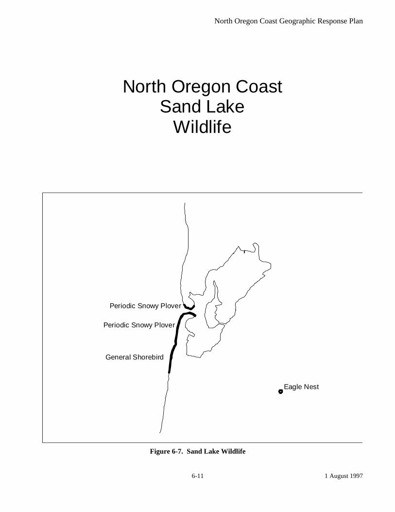
Eagle Nest
Periodic Snowy Plover
Periodic Snowy Plover
General Shorebird
North Oregon CoastSand Lake
Wildlife
Figure 6-7. Sand Lake Wildlife

North Oregon Coast Geographic Response Plan
1 August 1997 6-12
Peregrine Nest
Heron Rookery
Eagle Nest
North Oregon CoastLincoln City
Wildlife
Figure 6-8. Lincoln City Wildlife
North Oregon Coast Geographic Response Plan
1 August 1997 6-13
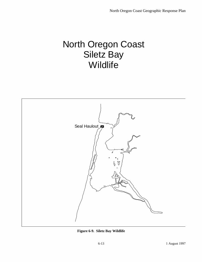
Seal Haulout
North Oregon CoastSiletz Bay
Wildlife
Figure 6-9. Siletz Bay Wildlife
North Oregon Coast Geographic Response Plan
1 August 1997 6-14
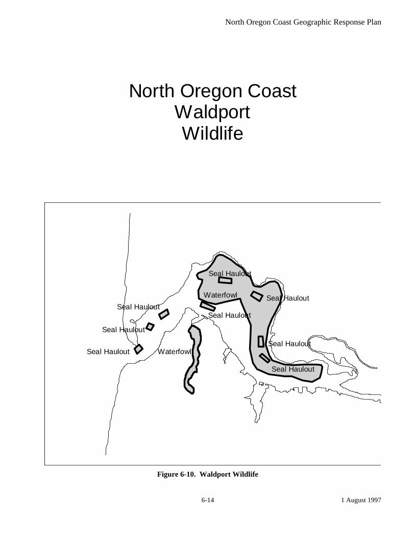
Seal Haulout
Seal Haulout
Seal HauloutSeal Haulout
Seal Haulout
Seal HauloutSeal Haulout
Seal Haulout
Waterfowl
Waterfowl
North Oregon CoastWaldportWildlife
Figure 6-10. Waldport Wildlife

North Oregon Coast Geographic Response Plan
1 October 1997 Change 2
7-1
7. Logistical Information The following list was compiled at the North Coast Geographic Response Plan Workshop held at Camp Rilea, OR on February 18, 1993. Areas of information include: command posts; communications; equipment cache locations; inventory of local support equipment; air support; access points; and other pertinent logistical support.
Table 7-1, Logistical Information
Subject Name Characteristics Contact Phone # Command Posts Warrenton Camp Rilea OR National Guard (503)
861-3835 Newport National Guard
Armory 541 SW Coast Hwy (541)
265-2761 Warrenton CG Airstation Astoria CG Group Astoria (503)
861-6211 Nehalem Nehalem State Park Lincoln County Emergency
Operations Center Lincoln City, Jim Hawley (541)
265-4165 Various Shilo Inns 1-800-
222-2244 Various Doubletree 1-800-
547-8010 Newport Hatfield Marine
Science Center (541)
867-0100 Florence Best Western 1-800-
782-0683 Communications Cellular One Cellular Phones (541)
265-2900 US West Cellular Phones (800)
477-7211 Clackamas Communications
UHF Mobile Frequency
(541) 267-4931
BLM 40 trucks with communications to center
Larry Matthews (541) 756-0100
MSRC Mobile Communications Van
(206) 252-1300
OERS Mobile Communications Van
1-800-452-0311
Equipment Cache Locations

North Oregon Coast Geographic Response Plan
1 October 1997 Change 2
7-2
Subject Name Characteristics Contact Phone # Astoria MSRC VOSS/
prepositioned boom & skimmers
(206) 252-1300
Astoria Clean Rivers Boats, Boom & skimmers
(503) 220-2091
Astoria Foss Environmental Boats, Boom & skimmers
(800) FESPILL
Inventory of Local Support Equipment
Astoria/Portland Fred Devine Salvage Equipment
Kerry Walsh (503) 283-5285
Newport Fairline Marine Al Wehren (541) 265-7819
Toledo M & E Septic (541) 563-3867
Newport Yaquina Marine Tow & Salvage
Scott Martin (541) 336-5205
Toledo Kaward Crane Bill Pankey (541) 563-3611
Astoria Bergerson Construction
Dennis Bjork (503) 325-7130
Helicopter Support/Air Support
Warrenton USCG Airstation Astoria
(503) 861-6211
North Bend USCG Airstation North Bend
(541) 265-5381
Newport USCG Auxiliary (541) 265-5381
Camp Rilea Oregon Air National Guard
116 Air Control Squadron (503) 861-7801
McMinnville Evergreen Helicopters (503) 472-9361
Astoria Astoria Flight Center (503) 861-1222
Access Points/Boat Ramps
Pacific Ocean Tolvana Park Dory Launch
Sand
Nehalem Bay Nehalem Bay Ramp Concrete Nehalem Bay Wheeler Ramp Concrete Nehalem Bay Paradise Cove Resort Asphalt Nehalem Bay Nehalem Bay State
Park Concrete
Nehalem Bay Brighton Moorage Asphalt

North Oregon Coast Geographic Response Plan
1 October 1997 Change 2
7-3
Subject Name Characteristics Contact Phone # Nehalem Bay Jetty Fishery Concrete Tillamook Bay Garibaldi Marina Asphalt Tillamook Bay Port of Bay City Asphalt Cape Meares Cape Meares Lake Gravel Tillamook Bay Memaloose Point Concrete Tillamook Marina Big Barn Marina Gravel Netarts Bay Netarts Landing Concrete Sand Lake Whalen Island County
Park Gravel
Row River Schwarz Park Hand Launch
Sand
Nestucca River Pacific City Ramp Asphalt Nestucca Bay Fisher Tract Gravel Little Nestucca River Little Nestucca Ramp Concrete Salmon River Knight Park Concrete Devils Lake West Side State Park Gravel Devils Lake Devils Lake Landing Gravel Siletz River Siletz Moorage Asphalt Depoe Bay Port of Depoe Bay Asphalt Yaquina Bay South Beach Marina Concrete Alsea Bay Port of Alsea Asphalt Alsea Bay McKinley’s Marina Asphalt Alsea River King Silver Gravel Alsea River Drift Creek Landing Concrete Alsea River Fishin Hole Trailer
Park Concrete
Alsea River Oaklands Marina Concrete Yachats River Yachats Landing Concrete Sutton Lake Sutton Launch Asphalt Property Access Information and Contacts
Staging Areas Astoria Tongue Point (503)
861-6211 Astoria Astoria Port Docks (503)
861-6211 Newport National Guard (541)
265-2761 Warrenton Camp Rilea (541)
861-3835 Tillamook County Fairgrounds 4603 Third Street (503)
842-2272 Tillamook National Guard
Armory 1510 Third Street (503)
842-2401

North Oregon Coast Geographic Response Plan
1 October 1997 Change 2
7-4
Subject Name Characteristics Contact Phone # Tillamook State Police 5995 Long Prairie Road (503)
842-4433 Tillamook City Police Laurel Ave (503)
842-2522 Recreational activities which could interfere
Tillamook County Rodeo June (503) 842-7526
Tillamook June Dairy Parade June (503) 842-7526
Tillamook Oregon Polka Festival July (503) 842-7526
Tillamook County Fair August (503) 842-7526
Garibaldi Fall Salmon Fishery Intense boat traffic Mid September-October (503) 842-2741
Tribal Resources Key Local Elected Officials
Astoria Mayor 1095 Duane St. (503) 325-5281
Hammond City Manager 801 Pacific Drive (503) 861-2712
Warrenton City Manager PO Box 250 (503) 861-3331
Seaside City Manager 989 Broadway (503) 738-5511
Cannon Beach City Manager 163 E. Gower (503) 436-1581
Manzanita City Manager PO Box C (503) 368-5343
Garibaldi City Manager PO Box 708 (541) 332-3327
Tillamook Mayor 210 Laurel (503) 842-2472
Fire Department Tillamook Fire Department Business phone (503)
842-7587 Garibaldi Fire Department Business phone (503)
842-2172 Local Personnel Support
Volunteers

North Oregon Coast Geographic Response Plan
1 October 1997 Change 2
7-5
Subject Name Characteristics Contact Phone # Statewide SOLV Jack McGowan (503)
647-9855 Coos Bay Audubon Ray Nolan (541)
756-2026 Newport Red Cross (541)
265-2182 Newport Oregon Shores
Coalition Jeff Ouderkirk (541)
265-8823 Marinas/Port docks Astoria Port of Astoria deep draft (503)
325-4521 Nehalem Port of Nehalem shallow draft (503)
368-5401 Garibaldi Port of Garibaldi shallow draft (503)322-
3292 Tillamook Port of Tillamook Bay shallow draft (503)
842-2413 Newport Port of Newport deep draft (541)
265-7758 Toledo Port of Toledo shallow draft (541)
336-5207 Waldport Port of Alsea shallow draft (541)
563-3872 Housing/ feeding/ support
Astoria Chamber of Commerce
(503) 325-6311
Cannon Beach Chamber of Commerce
(503) 436-2623
Garibaldi Chamber of Commerce
(503) 322-0301
Pacific City Chamber of Commerce
(503) 965-6161
Rockaway Beach Chamber of Commerce
(503) 355-8108
Seaside Chamber of Commerce
(503) 738-6391
Tillamook Chamber of Commerce
(503) 842-7526
Interim storage/permits
Astoria-Liquid McCall Oil Geary Powell (503) 221-5755
Astoria-Liquid Foss Maritime (800) FESPILL

North Oregon Coast Geographic Response Plan
1 October 1997 Change 2
7-6
Subject Name Characteristics Contact Phone # Newport-Liquid Hockema Oil (541)
265-5111 Astoria-Debris Tongue Point (503)
325-2211 Warrenton-Debris Fort Stevens (503)
861-1671 Fishing fleets & affiliated organizations*
Boat cleaning capability*
Garibaldi Boatyard Marine ways Newport Fariline Marine Al Wehren (541)
265-7819 Newport Riverbend Moorage Steve Webster (541)
265-9243 Newport Yaquina Boat
Equipment Dale Tindall (541)
336-5593 Safe havens Astoria Port of Astoria Newport Port of Newport Don Mann (541) 265-
7758 Coos Bay Port of Coos Bay Allan Rumbaugh (541) 267-
7678

North Oregon Coast Geographic Response Plan .
A-1 1 February 1997
Appendices Appendix A: Summary of Protection Techniques
Protection Techniques
Description Primary Logistical Requirements Limitations
ONSHORE Beach Berms A berm is constructed along the top of the mid-
inter tidal zone from sediments excavated along the downgradient side. The berm should be covered with plastic or geo-textile sheeting to minimize wave erosion.
• Bulldozer/Motor grader -1 • Personnel - equipment operator & 1 worker • Misc. - plastic or geotextile sheeting
• High wave energy • Large tidal range • Strong along shore currents
Geotextiles A roll of geotextile, plastic sheeting, or other impermeable material is spread along the bottom of the supra-tidal zone & fastened to the underlying logs or stakes placed in the ground.
• Geotextile - 3 m wide rolls • Personnel - 5 • Misc. - stakes or tie-down cord
• Low sloped shoreline • High spring tides • Large storms
Sorbent Barriers A barrier is constructed by installing two parallel lines of stakes across a channel, fastening wire mesh to the stakes & filling the space between with loose sorbents.
Per 30 meters of barrier • Wire mesh - 70 m x 2 m • Stakes - 20 • Sorbents - 30 m2 • Personnel - 2 • Misc. - fasteners, support lines, additional stakes, etc.
• Waves > 25 cm • Currents > 0.5 m/s • Tidal range > 2 m
Inlet Dams A dam is constructed across the channel using local soil or beach sediments to exclude oil from entering channel.
• Loader - 1 • Personnel - equipment operator & 1 worker or several
workers w/shovels
• Waves > 25 cm • Tidal range exceeding dam
height • Freshwater outflow
NEARSHORE Containment Booming
Boom is deployed in a "U" shape in front of the oncoming slick. The ends of the booms are anchored by work boats or drogues. The oil is contained within the "U" & prevented from reaching the shore.
For 150 meters Slick: • Boom - 280 m • Boats - 2 • Personnel - boat crews & 4 boom tenders • Misc. - tow lines, drogues, connectors, etc.
• High winds • Swells > 2 m • Breaking waves > 50 cm • Currents > 1.0 m/s
Exclusion Booming Boom is deployed across or around sensitive areas & anchored in place. Approaching oil is deflected or contained by boom.
Per 300 meters of Boom • Boats - 1 • Personnel - boat crew & 3 boom tenders • Misc.- 6 anchors, anchor line, buoys, etc.
• Currents > 0.5 m/s • Breaking waves > 50 cm • Water depth > 20 m
North Oregon Coast Geographic Response Plan .
A-2 1 February 1997
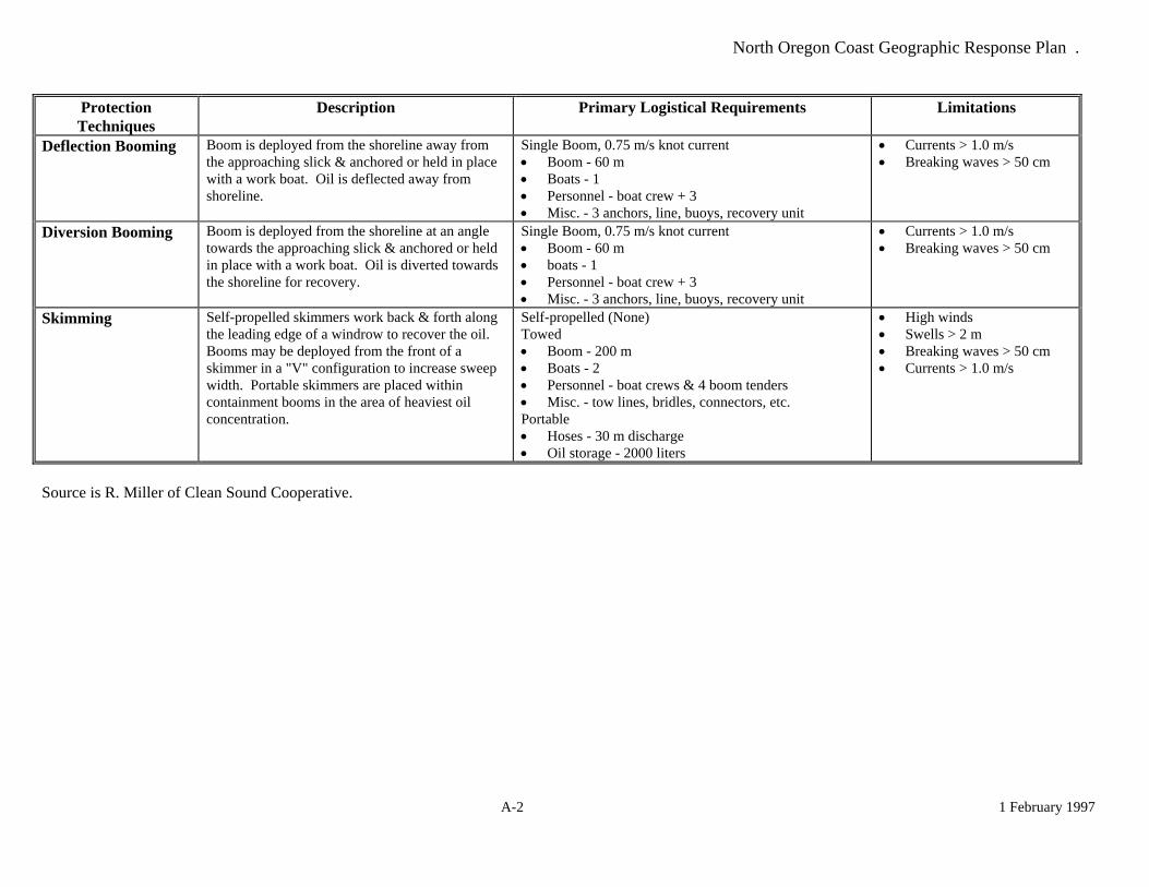
Protection Techniques
Description Primary Logistical Requirements Limitations
Deflection Booming Boom is deployed from the shoreline away from the approaching slick & anchored or held in place with a work boat. Oil is deflected away from shoreline.
Single Boom, 0.75 m/s knot current • Boom - 60 m • Boats - 1 • Personnel - boat crew + 3 • Misc. - 3 anchors, line, buoys, recovery unit
• Currents > 1.0 m/s • Breaking waves > 50 cm
Diversion Booming Boom is deployed from the shoreline at an angle towards the approaching slick & anchored or held in place with a work boat. Oil is diverted towards the shoreline for recovery.
Single Boom, 0.75 m/s knot current • Boom - 60 m • boats - 1 • Personnel - boat crew + 3 • Misc. - 3 anchors, line, buoys, recovery unit
• Currents > 1.0 m/s • Breaking waves > 50 cm
Skimming Self-propelled skimmers work back & forth along the leading edge of a windrow to recover the oil. Booms may be deployed from the front of a skimmer in a "V" configuration to increase sweep width. Portable skimmers are placed within containment booms in the area of heaviest oil concentration.
Self-propelled (None) Towed • Boom - 200 m • Boats - 2 • Personnel - boat crews & 4 boom tenders • Misc. - tow lines, bridles, connectors, etc. Portable • Hoses - 30 m discharge • Oil storage - 2000 liters
• High winds • Swells > 2 m • Breaking waves > 50 cm • Currents > 1.0 m/s
Source is R. Miller of Clean Sound Cooperative.

North Oregon Coast Geographic Response Plan
1 August 1997 B-1
Appendix B: Geographic Response Plan Contributors
Local Representatives Industry and Response Contractors Federal Representatives NOAA Dr. Sharon Christopherson Mr. Gary May USFWS Ms. Colleen Henson Mr. Roy Lowe United States Coast Guard LT Chris Curatilo LT(jg) Amy Beach
State Representatives Oregon Department of Environmental Quality Mr. Paul Slyman Mrs. Elizabeth Dimmick Mr. Jack Wylie Oregon Department of Fish and Wildlife Mr. Herman Biederbeck Mr. Jim Cadwell Mr. Dave Fox Mr. Dale Nelson Mr. Greg Robart Oregon State Service Center for Geographic Information Systems Mr. Richard Crucchiola Mrs. Patti Haggerty

North Oregon Coast Geographic Response Plan
1 August 1997 B-2
This Page Left Blank
North Oregon Coast Geographic Response Plan
C-1 1 October 1997 Change 2
Appendix C: Geographic Response Plan Comments/Corrections/Suggestions
If you have any questions regarding this document or find any errors with this document please notify one of the following agencies: • USCG Marine Safety Office Puget Sound, Planning Department • USCG Marine Safety Office Portland, Planning Department • Washington Department of Ecology, Central Programs Branch • Oregon Department of Environmental Quality, Land Quality Division • Idaho Emergency Response Commission • Environmental Protection Agency Region 10 You can use the tear out suggestion form or contact an agency using one of the following: Phone Numbers: USCG MSO Puget Sound (206) 217-6213 USCG MSO Portland (503) 247-4015 Washington DOE (360) 407-6971 Oregon DEQ (503) 229-5716 Idaho ERC (208) 334-3263 EPA (206) 553-6901 Internet Address: USCG [email protected] DEQ [email protected] Address: Commanding Officer United States Coast Guard MSO Puget Sound Planning Department 1519 Alaskan Way South Seattle, WA 98134-1192 Commanding Officer United States Coast Guard MSO Portland Planning Department 6767 North Basin Ave Portland, OR 97217-3992
Washington Department Of Ecology Central Programs Branch Policy and Planning Section P.O. Box 47600 Olympia, WA 98504 Oregon Department of Environmental Quality Land Quality Division 811 SW Sixth Avenue Portland, OR 97204
Office Of The Governor Idaho Emergency Response Commission 1109 Main Statehouse Boise, ID 83720-7000 Environmental Protection Agency Emergency Response Branch 1200 Sixth Avenue Seattle, WA 98101

North Oregon Coast Geographic Response Plan
C-2 1 October 1997 Change 2
This Page Left Blank

North Oregon Coast Geographic Response Plan
C-3 1 October 1997 Change 2
Geographic Response Plan
Comments/Corrections/Suggestions Directions: (Make a copy of this before you fill in so you have extra forms.) Fill in your name, address, agency, and phone number. Fill in the blanks regarding the location of information in the plan being commented on. Make comments in the space provided. Add extra sheets as necessary. Fold in thirds so the address label is visible and tape closed (don't staple). Name:______________________ Title:____________ Agency: __________________________ Address: ________________________________________________________________________ City: _______________________ State/Province:______ Zip/Postal Code: __________________ Phone: (____) _______________ Page Number: _______________ Location on page (chapter, section, paragraph) (e.g. 2.1, paragraph 3): _______________________ Comments:______________________________________________________________________ _______________________________________________________________________________ _______________________________________________________________________________ _______________________________________________________________________________ _______________________________________________________________________________ _______________________________________________________________________________ _______________________________________________________________________________ _______________________________________________________________________________ _______________________________________________________________________________ _______________________________________________________________________________