Embed Size (px)
Citation preview
1
NORTH MAHARASHTRA
UNIVERSITY,
JALGAON
M.A./M. Sc.
GEOGRAPHY
SEMESTER IIIed
AND IVth
NEW SYLLABI
WITH EFFECT FROM
JUNE 2014
2
M.A./ M. Sc. GEOGRAPHY
JOB OPPORTUNITY
Geography has wide range of applications in fields like transportation,
environmental sciences, airline route and shipping route planning, civil services,
cartography (map making), satellite technology, population council, meteorology
departments, education, disaster management are some of the careers one can op
for. The job role as well as nature of work varies depending upon the job profile.
Some of the popular opportunities within the field of geography in India include—
economical geography, cultural geography, political geography, historical
geography, tourism geography, regional geography, and climatology and so on. One
can specialise in related fields and become a geographer.
1) Govt Department; A geographer can avail job opportunities in government
departments (like planning and developmental commissions, forestry,
environmental, and disaster management departments etc), travel agencies,
manufacturing firms, text book and map publishers, media agencies, etc.
2) Cartographer: Many people choose to work as a cartographer who is a person
with extensive knowledge about maps and is involved in making maps, charts,
globes, and models of Earth and other planets.
3) Surveyor: Many others with a degree in geography also opt to work as a
surveyor. A surveyor is the person who is involved in measuring the surface of
land, distance between two places through mathematical calculations. Their job
involves lot of on the field work and is majorly recruited by state and central
survey departments, construction companies and so on. At SY and TY level
Plane Table Survey, GPS Surveys are included in the syllabus. Many posts of
surveyors are vacant in privet sector and Govt department of survey.
3
4) GPS Surveyors: In recent days even the fields of GIS as well as Remote Sensing
are providing job opportunities to people with the educational background in
geography and related specialisations. And not to forget the management of the
lifelines of most modes of transport that occurs via travel and tourism wherein
people with a background in geography are often recruited (along with the
required certifications) as tour operators, itinerary planners, tour guides and so
on. Also those with PhD or relevant master’s can also opt to teach the subject at
school, college or masters level or may be involved in developing educational
content for the relevant subject.
Indeed, it is correctly said that geography is everywhere and opens our eyes to the
world we live in, and so for those curious souls who love to know more and
explore about the earth, the road towards geography may lead you to your final
destination! Get going…
5) GIS and Remote Sensing Fields: Geography as a career provides multiple job
options. With the increased use of satellite technology and Geographical
Information System, geography is becoming a more promising career option than
it was ever before. The GIS is a computer based information system which is
used to digitally represent and analyse the geographic features present on the
earth surface.
6) Geographers provide their services in diverse fields. There are comparatively few
geographers so they are in high demand at national and international level. The
remuneration depends on the potential, experience, seniority and type of
organisation. Generally private companies pay awesome wage along with other
benefits, when compared with the government and public organisation. In the
field of geography, a qualified person can expect a starting salary somewhere
around Rs. 15,000 - 25,000 per month. The senior persons in private sector may
4
draw more than Rs.1,20, 000 per month. Consultants also get attractive
consultancy fees.
7) Drafter: He/she associate closely with engineers and architectures. It involves
planning, housing and development projects in terms of their location and
utilization.
8) Government employer: Central government agencies employ geographers for
mapping, intelligence work and remote sensing interpretation. State and local
governments employ geographers on planning and development commissions.
9) Urban and regional planner: Concerned with planning, housing and
Development projects with respect to their location and utilization of available
land-space.
10) GIS specialist: City governments, county agencies and other government
agencies and private groups are often in need of experienced GIS professionals.
11) Climatologist: Agencies viz. National Weather Service, news media, the
Weather Channel and other government entities occasionally need climatologist.
A geographer with experience and vast coursework in meteorology and
climatology serves as the best climatologist.
12) Transportation manager: The regional transit authorities or shipping,
logistics and transportation companies requires in transportation geography.
13) Environmental Manager: The environmental assessment, clean-up and
management companies require a geographer for environmental impact
reports. It's often a wide-open field with tremendous growth opportunities.
14) Science (Geography) writer: One can serve as a science writer or a travel
writer for a magazine or newspaper.
15) Researcher: Many Government and non-government institutes along with
research centres offers several career options for qualified geographers with
numerous specializations.
16) Urban planner.
5
17) Teacher/Professor: The college teachers, school teachers and university
teacher. Depending upon the experience and degrees obtained.
18) Demographer: In government and research organizations.
19) Government officer: Geographical Survey of India/State and Central
government provides job opportunities.
20) Careers in Indian Navy: The Indian Navy is the seventh largest in the world
and is a well knit, cohesive fighting force with tri dimensional capabilities. The
Indian Navy provides you all the training you need and help you make the most of
what you have your talents, your skills, your spirit and your aspirations. You get
very challenging job and get chance to travel widely.
6
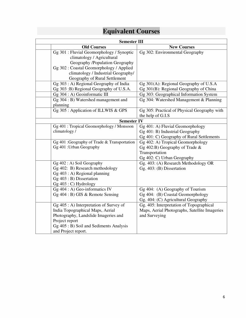
Equivalent Courses
Semester III
Old Courses New Courses
Gg 301 : Fluvial Geomorphology / Synoptic
climatology / Agricultural
Geography /Population Geography
Gg 302 : Coastal Geomorphology / Applied
climatology / Industrial Geography/
Geography of Rural Settlement
Gg 302: Environmental Geography
Gg 303 : A) Regional Geography of India
Gg 303 :B) Regional Geography of U.S.A.
Gg 301(A): Regional Geography of U.S.A
Gg 301(B): Regional Geography of China
Gg 304 : A) Geoinformatic III Gg 303: Geographical Information System
Gg 304 : B) Watershed management and
planning
Gg 304: Watershed Management & Planning
Gg 305 : Application of ILLWIS & GPS Gg 305: Practical of Physical Geography with
the help of G.I.S
Semester IV
Gg 401 : Tropical Geomorphology / Monsoon
climatology / Gg 401: A) Fluvial Geomorphology
Gg 401: B) Industrial Geography
Gg 401: C) Geography of Rural Settlements
Gg 401 :Geography of Trade & Transportation
Gg 401 :Urban Geography
Gg 402: A) Tropical Geomorphology
Gg 402:B) Geography of Trade &
Transportation
Gg 402: C) Urban Geography
Gg 402 : A) Soil Geography
Gg 402: B) Research methodology
Gg 403 : A) Regional planning
Gg 403 : B) Dissertation
Gg 403 : C) Hydrology
Gg. 403: (A) Research Methodology OR
Gg. 403: (B) Dissertation
Gg 404 : A) Geo-informatics IV
Gg 404 : B) GIS & Remote Sensing
Gg 404: (A) Geography of Tourism
Gg 404: (B) Coastal Geomorphology
Gg. 404: (C) Agricultural Geography
Gg 405 : A) Interpretation of Survey of
India Topographical Maps, Aerial
Photography, Landslide Imageries and
Project report
Gg 405 : B) Soil and Sediments Analysis
and Project report.
Gg. 405: Interpretation of Topographical
Maps, Aerial Photographs, Satellite Imageries
and Surveying

7
New Syllabus of M.A./M.Sc Geography
W.E.F June 2014
Semester - III
Gg 301(A): Regional Geography of U.S.A
OR
Gg 301(B) Regional Geography of China
Gg 302: Environmental Geography
Gg 303: Geographical Information System
Gg 304: Watershed Management & Planning
Gg 305: Practical of Physical Geography with the help of G.I.S
Semester - IV
Gg 401: (A) Fluvial Geomorphology
OR
(B) Industrial Geography
OR
(C) Geography of Rural Settlements
Gg 402: (A) Tropical Geomorphology
OR
(B) Geography of Trade & Transportation
OR
(C) Urban Geography
Gg. 403: (A) Research Methodology
OR
Gg. 403: (B) Dissertation
Gg 404: (A) Geography of Tourism
OR
Gg. 404: (B) Coastal Geomorphology
OR
Gg. 404: (C) Agricultural Geography
Gg. 405: Interpretation of Topographical Maps, Aerial Photographs, Satellite
Imageries & Surveying
8
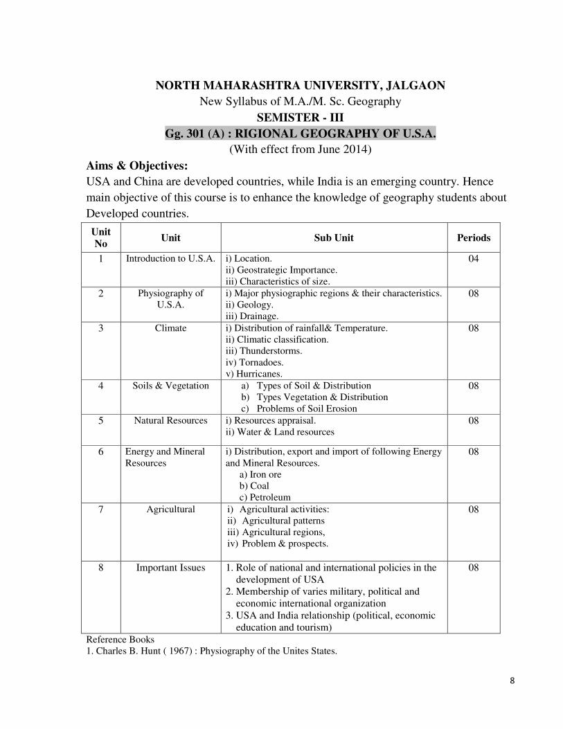
NORTH MAHARASHTRA UNIVERSITY, JALGAON
New Syllabus of M.A./M. Sc. Geography
SEMISTER - III
Gg. 301 (A) : RIGIONAL GEOGRAPHY OF U.S.A.
(With effect from June 2014)
Aims & Objectives:
USA and China are developed countries, while India is an emerging country. Hence
main objective of this course is to enhance the knowledge of geography students about
Developed countries.
Unit
No Unit Sub Unit Periods
1 Introduction to U.S.A. i) Location.
ii) Geostrategic Importance.
iii) Characteristics of size.
04
2 Physiography of
U.S.A. i) Major physiographic regions & their characteristics.
ii) Geology.
iii) Drainage.
08
3 Climate i) Distribution of rainfall& Temperature.
ii) Climatic classification.
iii) Thunderstorms.
iv) Tornadoes.
v) Hurricanes.
08
4 Soils & Vegetation a) Types of Soil & Distribution b) Types Vegetation & Distribution c) Problems of Soil Erosion
08
5 Natural Resources i) Resources appraisal.
ii) Water & Land resources 08
6 Energy and Mineral
Resources
i) Distribution, export and import of following Energy
and Mineral Resources.
a) Iron ore
b) Coal
c) Petroleum
08
7 Agricultural
i) Agricultural activities: ii) Agricultural patterns iii) Agricultural regions, iv) Problem & prospects.
08
8 Important Issues 1. Role of national and international policies in the
development of USA
2. Membership of varies military, political and
economic international organization
3. USA and India relationship (political, economic
education and tourism)
08
Reference Books
1. Charles B. Hunt ( 1967) : Physiography of the Unites States.
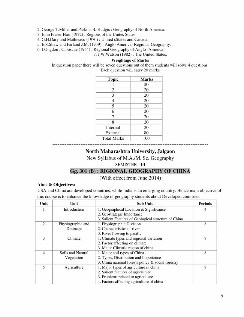
9
2. George T.Miller and Parkins B. Hudgis : Geography of North America.
3. John Fraser Hart (1972) : Regions of the Unites States.
4. G.H.Dary and Mathieacu (1970) : United sStates and Canada.
5. E.S.Shaw and Farland J.M. (1959) : Anglo America- Regional Geography.
6. LOngdon , C.Foscue (1954) : Regional Geography of Anglo- America.
7. J.W.Watson (1982) : The United States. Weightage of Marks
In question paper there will be seven questions out of them students will solve 4 questions.
Each question will carry 20 marks
Topic Marks
1 20
2 20
3 20
4 20
5 20
6 20
7 20
8 20
Internal 20
External 80
Total Marks 100
-----------------------------------------------------------------------------------------
North Maharashtra University, Jalgaon
New Syllabus of M.A./M. Sc. Geography
SEMISTER - III
Gg. 301 (B) : RIGIONAL GEOGRAPHY OF CHINA
(With effect from June 2014)
Aims & Objectives:
USA and China are developed countries, while India is an emerging country. Hence main objective of
this course is to enhance the knowledge of geography students about Developed countries.
Unit Unit Sub Unit Periods
1 Introduction 1. Geographical Location & Significance
2. Geostrategic Importance
3. Salient Features of Geological structure of China
4
2 Physiographic and
Drainage
1. Physiographic Division
2. Characteristics of river
3. River flowing to pacific
8
3 Climate 1. Climate types and regional variation
2. Factor affecting on climate
3. Major Climatic region of china
8
4 Soils and Natural
Vegetation
1. Major soil types of China
2. Types, Distribution and Importance
3. China national forests policy & social forestry
8
5 Agriculture 1. Major types of agriculture in china
2. Salient features of agriculture
3. Problems related to agriculture
4. Factors affecting agriculture of china
8
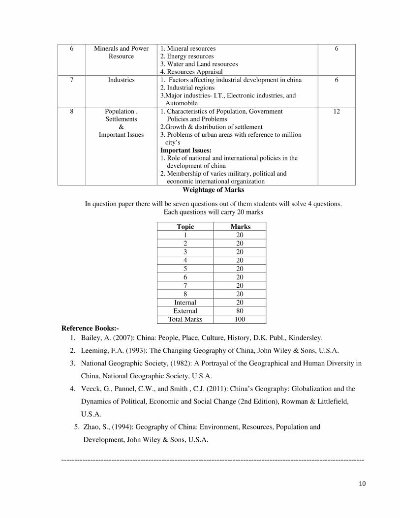
10
6 Minerals and Power
Resource
1. Mineral resources
2. Energy resources
3. Water and Land resources
4. Resources Appraisal
6
7 Industries 1. Factors affecting industrial development in china
2. Industrial regions
3.Major industries- I.T., Electronic industries, and
Automobile
6
8 Population ,
Settlements
&
Important Issues
1. Characteristics of Population, Government
Policies and Problems
2.Growth & distribution of settlement
3. Problems of urban areas with reference to million
city’s
Important Issues: 1. Role of national and international policies in the
development of china
2. Membership of varies military, political and
economic international organization
12
Weightage of Marks
In question paper there will be seven questions out of them students will solve 4 questions.
Each questions will carry 20 marks
Topic Marks
1 20
2 20
3 20
4 20
5 20
6 20
7 20
8 20
Internal 20
External 80
Total Marks 100
Reference Books:-
1. Bailey, A. (2007): China: People, Place, Culture, History, D.K. Publ., Kindersley.
2. Leeming, F.A. (1993): The Changing Geography of China, John Wiley & Sons, U.S.A.
3. National Geographic Society, (1982): A Portrayal of the Geographical and Human Diversity in
China, National Geographic Society, U.S.A.
4. Veeck, G., Pannel, C.W., and Smith , C.J. (2011): China’s Geography: Globalization and the
Dynamics of Political, Economic and Social Change (2nd Edition), Rowman & Littlefield,
U.S.A.
5. Zhao, S., (1994): Geography of China: Environment, Resources, Population and
Development, John Wiley & Sons, U.S.A.
-------------------------------------------------------------------------------------------------------------------
11
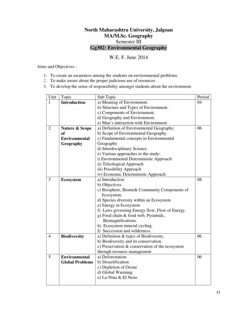
North Maharashtra University, Jalgoan
MA/M.Sc. Geography Semester III
Gg302: Environmental Geography
W.E. F. June 2014
Aims and Objectives -
1. To create an awareness among the students on environmental problems.
2. To make aware about the proper judicious use of resources
3. To develop the sense of responsibility amongst students about the environment.
Unit Topic Sub Topic Period
1 Introduction a) Meaning of Environment.
b) Structure and Types of Environment.
c) Components of Environment.
d) Geography and Environment.
e) Man’s interaction with Environment
04
2 Nature & Scope
of
Environmental
Geography
a) Definition of Environmental Geography.
b) Scope of Environmental Geography.
c) Fundamental concepts in Environmental
Geography
d) Interdisciplinary Science.
e) Various approaches to the study:
i) Environmental Deterministic Approach
ii) Teleological Approach
iii) Possibility Approach
iv) Economic Deterministic Approach
06
3 Ecosystem a) Introduction
b) Objectives
c) Biosphere, Biome& Community Components of
Ecosystem.
d) Species diversity within an Ecosystem
e) Energy in Ecosystem
f) Laws governing Energy flow, Flow of Energy.
g) Food chain & food web, Pyramids,
Biomagnifications.
h) Ecosystem mineral cycling.
I) Succession and wilderness.
08
4 Biodiversity a) Definition & types of Biodiversity.
b) Biodiversity and its conservation.
c) Preservation & conservation of the ecosystem
through resource management
06
5 Environmental
Global Problems
a) Deforestation
b) Desertification
c) Depletion of Ozone
d) Global Warming
e) La-Nina & El Neno
06
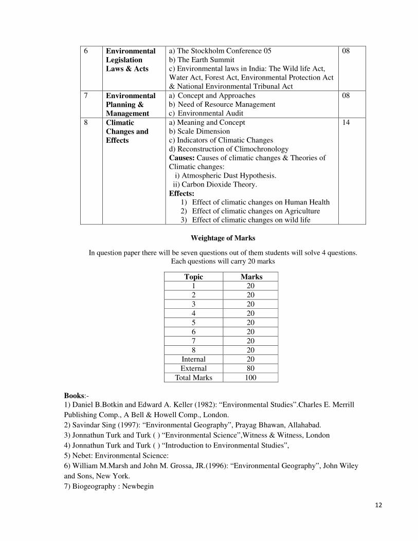
12
6 Environmental
Legislation
Laws & Acts
a) The Stockholm Conference 05
b) The Earth Summit
c) Environmental laws in India: The Wild life Act,
Water Act, Forest Act, Environmental Protection Act
& National Environmental Tribunal Act
08
7 Environmental
Planning &
Management
a) Concept and Approaches
b) Need of Resource Management
c) Environmental Audit
08
8 Climatic
Changes and
Effects
a) Meaning and Concept
b) Scale Dimension
c) Indicators of Climatic Changes
d) Reconstruction of Climochronology
Causes: Causes of climatic changes & Theories of
Climatic changes:
i) Atmospheric Dust Hypothesis.
ii) Carbon Dioxide Theory.
Effects:
1) Effect of climatic changes on Human Health
2) Effect of climatic changes on Agriculture
3) Effect of climatic changes on wild life
14
Weightage of Marks
In question paper there will be seven questions out of them students will solve 4 questions.
Each questions will carry 20 marks
Topic Marks
1 20
2 20
3 20
4 20
5 20
6 20
7 20
8 20
Internal 20
External 80
Total Marks 100
Books:-
1) Daniel B.Botkin and Edward A. Keller (1982): “Environmental Studies”.Charles E. Merrill
Publishing Comp., A Bell & Howell Comp., London.
2) Savindar Sing (1997): “Environmental Geography”, Prayag Bhawan, Allahabad.
3) Jonnathun Turk and Turk ( ) “Environmental Science”,Witness & Witness, London
4) Jonnathun Turk and Turk ( ) “Introduction to Environmental Studies”,
5) Nebet: Environmental Science:
6) William M.Marsh and John M. Grossa, JR.(1996): “Environmental Geography”, John Wiley
and Sons, New York.
7) Biogeography : Newbegin
13
8) Girish Chopra (2006): “Environmental Geography”, Commonwealt, New Delhi.
9) Centre for Science and Environment, New Delhi:“The State of Indias’s Environment,1984-85”.
10) Kevin J Gaston and John I Spicer (2004): “Biodiversity : An Introduction”, Blackwell Publishing.
11) Noel De Nevevs: “Air Pollution control Engineering”, Mc Graw hill, International edition civil
Engineering Series
12) R. Kumar: “Environmental Pollution & Health”,Ashish Publication, 818 Punjabi Bag,New Delhi
13) C. N. Mehta (1991): “Environmental Protection & Laws”,
-------------------------------------------------------------------------------------------------------------------------
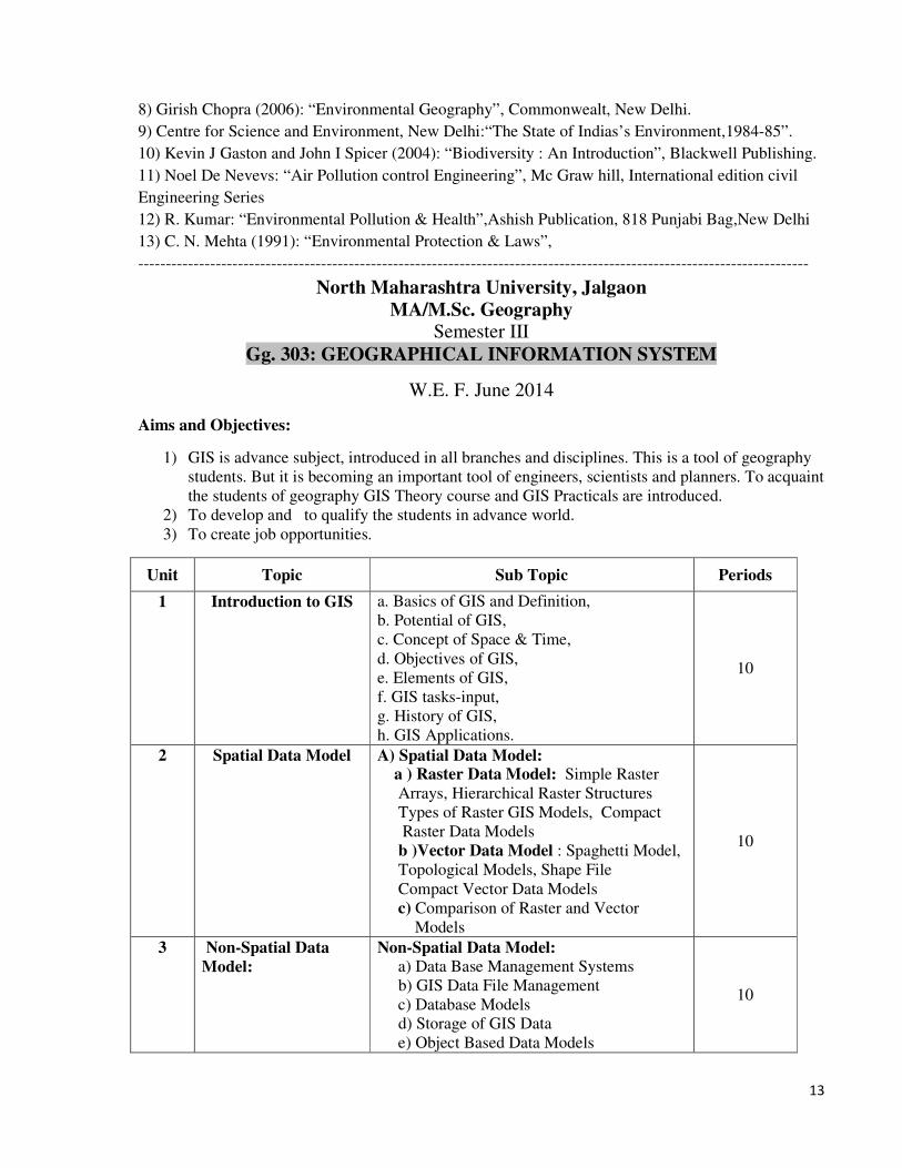
North Maharashtra University, Jalgaon
MA/M.Sc. Geography Semester III
Gg. 303: GEOGRAPHICAL INFORMATION SYSTEM
W.E. F. June 2014
Aims and Objectives:
1) GIS is advance subject, introduced in all branches and disciplines. This is a tool of geography
students. But it is becoming an important tool of engineers, scientists and planners. To acquaint
the students of geography GIS Theory course and GIS Practicals are introduced.
2) To develop and to qualify the students in advance world.
3) To create job opportunities.
Unit Topic Sub Topic Periods
1 Introduction to GIS a. Basics of GIS and Definition,
b. Potential of GIS,
c. Concept of Space & Time,
d. Objectives of GIS,
e. Elements of GIS,
f. GIS tasks-input,
g. History of GIS,
h. GIS Applications.
10
2 Spatial Data Model A) Spatial Data Model: a ) Raster Data Model: Simple Raster
Arrays, Hierarchical Raster Structures
Types of Raster GIS Models, Compact
Raster Data Models
b )Vector Data Model : Spaghetti Model,
Topological Models, Shape File
Compact Vector Data Models
c) Comparison of Raster and Vector
Models
10
3 Non-Spatial Data
Model:
Non-Spatial Data Model:
a) Data Base Management Systems
b) GIS Data File Management
c) Database Models
d) Storage of GIS Data
e) Object Based Data Models
10
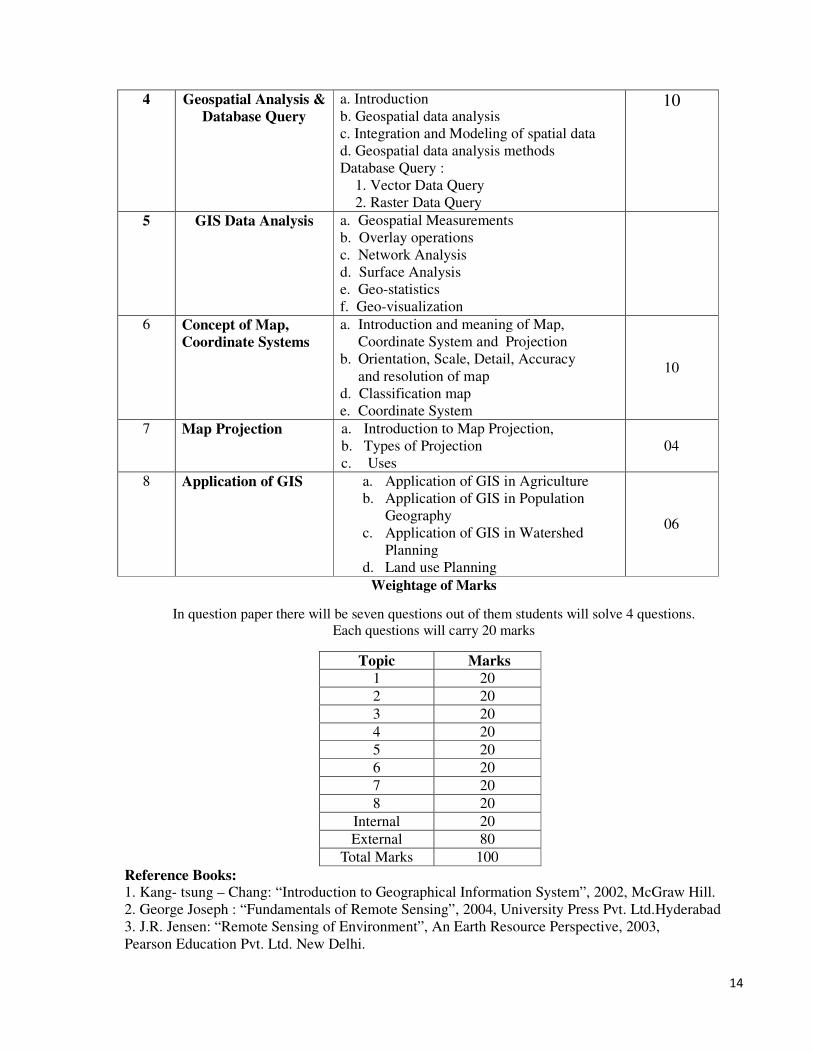
14
4 Geospatial Analysis &
Database Query
a. Introduction
b. Geospatial data analysis
c. Integration and Modeling of spatial data
d. Geospatial data analysis methods
Database Query :
1. Vector Data Query
2. Raster Data Query
10
5 GIS Data Analysis a. Geospatial Measurements
b. Overlay operations
c. Network Analysis
d. Surface Analysis
e. Geo-statistics
f. Geo-visualization
6 Concept of Map,
Coordinate Systems
a. Introduction and meaning of Map,
Coordinate System and Projection
b. Orientation, Scale, Detail, Accuracy
and resolution of map
d. Classification map
e. Coordinate System
10
7 Map Projection a. Introduction to Map Projection,
b. Types of Projection
c. Uses
04
8 Application of GIS a. Application of GIS in Agriculture
b. Application of GIS in Population
Geography
c. Application of GIS in Watershed
Planning
d. Land use Planning
06
Weightage of Marks
In question paper there will be seven questions out of them students will solve 4 questions.
Each questions will carry 20 marks
Topic Marks
1 20
2 20
3 20
4 20
5 20
6 20
7 20
8 20
Internal 20
External 80
Total Marks 100
Reference Books: 1. Kang- tsung – Chang: “Introduction to Geographical Information System”, 2002, McGraw Hill.
2. George Joseph : “Fundamentals of Remote Sensing”, 2004, University Press Pvt. Ltd.Hyderabad
3. J.R. Jensen: “Remote Sensing of Environment”, An Earth Resource Perspective, 2003,
Pearson Education Pvt. Ltd. New Delhi.
15
4. Lillesand T.M. & Kiefer R.W. 2002, “Remote Sensing and Image Interpretation”,
John Wiley and Sons New Delhi.
5. P.A. Burrough & R.A. McDonnell: “Principles of Geographical Information System”,2000 Oxford
University Press.
6. C.P.Lo & Albert K.W.Yeung: “Concepts and techniques of Geographic Information System”, 2002,
Prentice Hall, India.
7. Paul A. Lonfley, Michel F. Goodchild, D.J.Maguire & D.W. Rhind: “Introduction of Geographic
Information Systems and Science”, 2002, John Wiley & Sons Lt.
8. Chanda B. Dattaa D., Mujumdar : Digital Image Processing and Analysis ,Prentice- Hall of India 2001.
9. Prithvish Nag and M. Kudrat : Digital Remote Sensing , Concept PublishingC o. New Delhi-1998.
10. Roy P.S. : Geographical Information Science Vol. I , IIRS 2000.
11. Demers M.N. : Fundamentals of Geographic Information Systems 2nd ed.,
12. JohnWiley & Sons: Introduction to Geographic Information System and Science, (2002) .
13. Basudeb Bhatta. : Remote Sensing and GIS, 2nd ed., Oxford university press, Printed by-Radha press,
Delhi, 110031.
14. M. Anji Reddy.: Text book of Remote Sensing and GIS, 3rd ed., BS Publications, Hydrabad-72.
----------------------------------------------------------------------------------------------------------
North Maharashtra University, Jalgaon
MA/M.Sc. Geography New Syllabus
Semester III
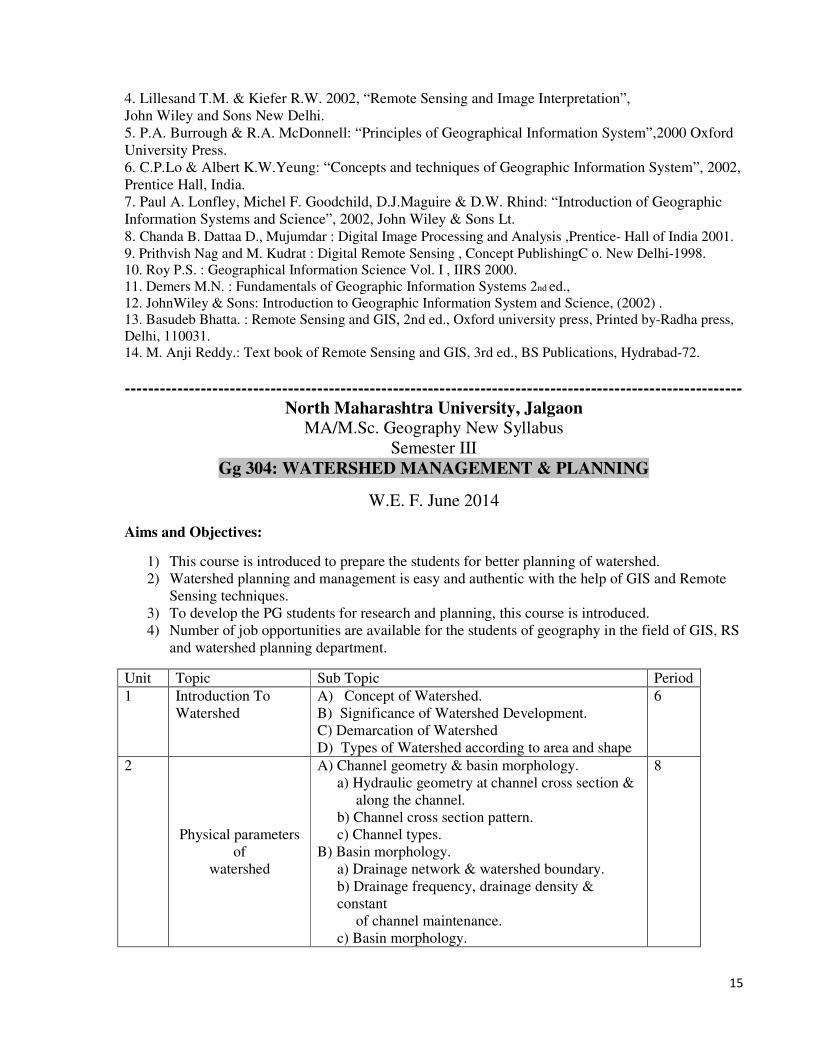
Gg 304: WATERSHED MANAGEMENT & PLANNING
W.E. F. June 2014
Aims and Objectives:
1) This course is introduced to prepare the students for better planning of watershed.
2) Watershed planning and management is easy and authentic with the help of GIS and Remote
Sensing techniques.
3) To develop the PG students for research and planning, this course is introduced.
4) Number of job opportunities are available for the students of geography in the field of GIS, RS
and watershed planning department.
Unit Topic Sub Topic Period
1 Introduction To
Watershed
A) Concept of Watershed.
B) Significance of Watershed Development.
C) Demarcation of Watershed
D) Types of Watershed according to area and shape
6
2
Physical parameters
of
watershed
A) Channel geometry & basin morphology.
a) Hydraulic geometry at channel cross section &
along the channel.
b) Channel cross section pattern.
c) Channel types.
B) Basin morphology.
a) Drainage network & watershed boundary.
b) Drainage frequency, drainage density &
constant
of channel maintenance.
c) Basin morphology.
8
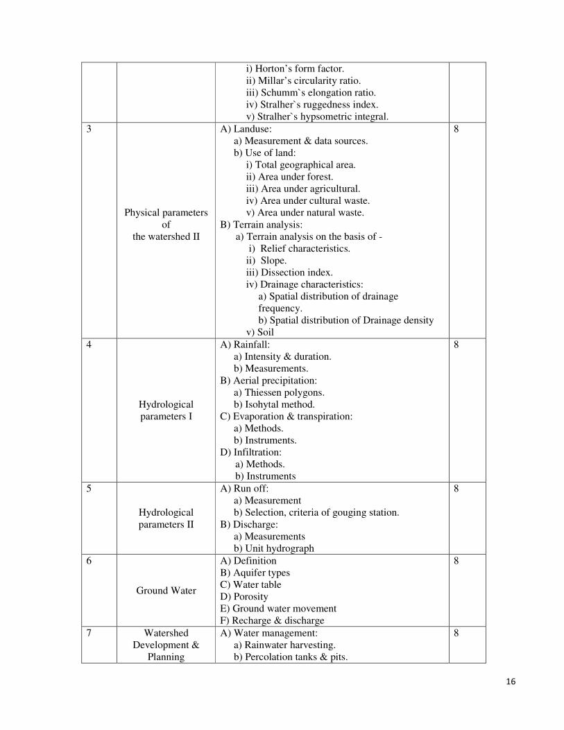
16
i) Horton’s form factor.
ii) Millar’s circularity ratio.
iii) Schumm`s elongation ratio.
iv) Stralher`s ruggedness index.
v) Stralher`s hypsometric integral.
3
Physical parameters
of
the watershed II
A) Landuse:
a) Measurement & data sources.
b) Use of land:
i) Total geographical area.
ii) Area under forest.
iii) Area under agricultural.
iv) Area under cultural waste.
v) Area under natural waste.
B) Terrain analysis:
a) Terrain analysis on the basis of -
i) Relief characteristics.
ii) Slope.
iii) Dissection index.
iv) Drainage characteristics:
a) Spatial distribution of drainage
frequency.
b) Spatial distribution of Drainage density
v) Soil
8
4
Hydrological
parameters I
A) Rainfall:
a) Intensity & duration.
b) Measurements.
B) Aerial precipitation:
a) Thiessen polygons.
b) Isohytal method.
C) Evaporation & transpiration:
a) Methods.
b) Instruments.
D) Infiltration:
a) Methods.
b) Instruments
8
5
Hydrological
parameters II
A) Run off:
a) Measurement
b) Selection, criteria of gouging station.
B) Discharge:
a) Measurements
b) Unit hydrograph
8
6
Ground Water
A) Definition
B) Aquifer types
C) Water table
D) Porosity
E) Ground water movement
F) Recharge & discharge
8
7 Watershed
Development &
Planning
A) Water management:
a) Rainwater harvesting.
b) Percolation tanks & pits.
8

17
c) Sprinkle irrigation.
B) Development programmes:
a) Artificial recharge of ground water.
b) Dams & weirs.
c) Interlinking of rivers.
8
Sample of
Watershed
Management and
Planning
A) Types of Survey for watershed development
i) Physical survey
ii) Hydrological
iii) Land use
iv) Survey of Resources
B) Advance Techniques for watershed development
i) Remote sensing data analysis
ii) Application of GIS software
6
Weightage of Marks
In question paper there will be seven questions out of them students will solve 4 questions.
Each questions will carry 20 marks
Topic Marks
1 20
2 20
3 20
4 20
5 20
6 20
7 20
8 20
Internal 20
External 80
Total Marks 100
Reference Books 1. Murthy J.V.S. (1994) : Watershed Management in India, Wiley Eastern Ltd. New Delhi.
2. Paranjape S. and Other (19980 : Water based Development, Bharat Gyan Vigyan Samithi, New Delhi.
3. Mutreja K.N. (1990) : Applied Hydrology, Tata Mc Graw Hill Pub. Co. Ltd. New Delhi.
4. Shing R.J. (2000) : Watershed planning and Management, Yash Publishing House, Bikaner.
5. Chanda B. , Dattaa D., Mujumdar : Digital Image Processing and Analysis, Prentice- Hall of India 2001.
6. Prithvish Nag and M. Kudrat : Digital Remote Sensing , Concept Publishing Co. New Delhi-1998.
7. Basudeb Bhatta. : Remote Sensing and GIS, 2nd ed., Oxford university press, Printed by-Radha press,
Delhi, 110031.
13. M. Anji Reddy.: Text book of Remote Sensing and GIS, 3rd Ed., BS Publications, Hydrabad-72
18
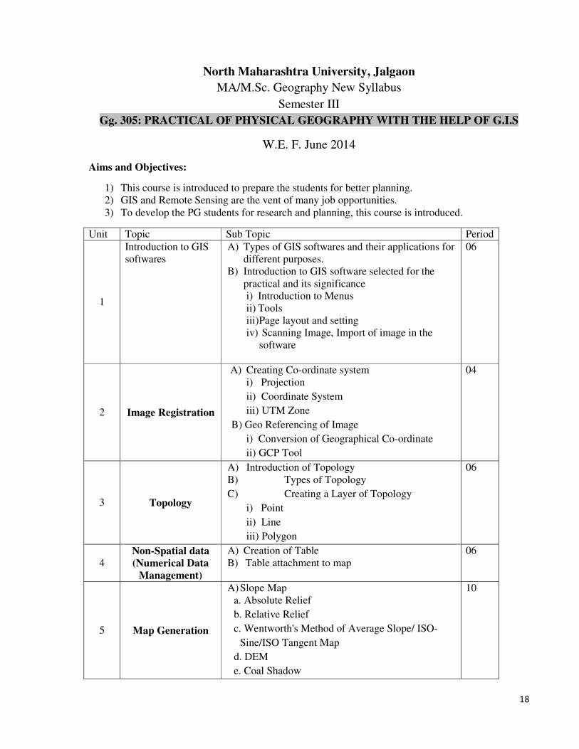
North Maharashtra University, Jalgaon
MA/M.Sc. Geography New Syllabus
Semester III
Gg. 305: PRACTICAL OF PHYSICAL GEOGRAPHY WITH THE HELP OF G.I.S
W.E. F. June 2014
Aims and Objectives:
1) This course is introduced to prepare the students for better planning.
2) GIS and Remote Sensing are the vent of many job opportunities.
3) To develop the PG students for research and planning, this course is introduced.
Unit Topic Sub Topic Period
1
Introduction to GIS
softwares
A) Types of GIS softwares and their applications for
different purposes.
B) Introduction to GIS software selected for the
practical and its significance
i) Introduction to Menus
ii) Tools
iii) Page layout and setting
iv) Scanning Image, Import of image in the
software
06
2 Image Registration
A) Creating Co-ordinate system
i) Projection
ii) Coordinate System
iii) UTM Zone
B) Geo Referencing of Image
i) Conversion of Geographical Co-ordinate
ii) GCP Tool
04
3 Topology
A) Introduction of Topology
B) Types of Topology
C) Creating a Layer of Topology
i) Point
ii) Line
iii) Polygon
06
4 Non-Spatial data
(Numerical Data
Management)
A) Creation of Table
B) Table attachment to map
06
5 Map Generation
A) Slope Map
a. Absolute Relief
b. Relative Relief
c. Wentworth's Method of Average Slope/ ISO-
Sine/ISO Tangent Map
d. DEM
e. Coal Shadow
10

19
6 Profile
Representation
A) Cross Profile and Histogram of Basin
B) Longitudinal Profile of Rivers
C) Interpretation of Profile
06
7 Representation of
Physical Data
A) Climo-graph
B) Hyther-graph
C) Wind rose
06
8 GPS Survey
A) History of GPS
B) Types of GPS
C) Components of GPS
D) Triangulating from Satellites
E) Getting perfect timing
F) Knowing Location of Satellite in the Space
G) Reading on GPS
H) Survey with GPS:
i) Lat-long and elevation of Surveyed Points
ii) Drawing of Layout
iii) Area Measurement from the layout
06
9
Project Report on
GPS Survey
A) Project Report of GPS Survey (Individual)
1) Survey of College Campus/ Play ground/
Built up area of department/ Agricultural field
with the help of GPS.
2) Layout of surveyed area
3) Actual original map/ layout of surveyed area
4) Area difference between Original map and
surveyed layout.
B) Students should prepare Project on GPS survey
C) At the time of Examination every students should
present a report with the help of PPT
10
Weightage of Marks
In question paper there will be six questions All questions will be compulsory.
Question
No
Topic Marks Question
1 5 15 Map Preparation
2 6 15 Map Preparation
3 7 15 Map Preparation
4 8 10 GPS Survey in Field
5(A) 9 10 Project Report
5(B) 9 05 Project Report
Presentation
6 1 to 9 10 Oral & Journal
Internal 20
External 80
Total
Marks
100
20
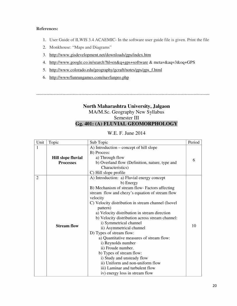
References:
1. User Guide of ILWIS 3.4 ACAEMIC- In the software user guide file is given. Print the file
2. Monkhouse: “Maps and Diagrams”
3. http://www.gisdevelopment.net/downloads/gps/index.htm
4. http://www.google.co.in/search?hl=en&q+gps+software & meta=&aq=3&oq+GPS
5. http://www.colorado.edu/geography/gcraft/notes/gps/gps_f.html
6. http://www/funrungames.com/navfunpro.php
-----------------------------------------------------------------------------------------------------------------------
North Maharashtra University, Jalgaon MA/M.Sc. Geography New Syllabus
Semester III
Gg. 401: (A) FLUVIAL GEOMORPHOLOGY
W.E. F. June 2014
Unit Topic Sub Topic Period
1
Hill slope fluvial
Processes
A) Introduction – concept of hill slope
B) Process:
a) Through flow
b) Overland flow (Definition, nature, type and
Characteristics)
C) Hill slope profile
6
2
Stream flow
A) Introduction: a) Fluvial energy concept
b) Energy
B) Mechanism of stream flow- Factors affecting
stream flow and chezy’s equation of stream flow
velocity
C) Velocity distribution in stream channel (Isovel
pattern)
a) Velocity distribution in stream direction
b) Velocity distribution across stream channel:
i) Symmetrical channel
ii) Asymmetrical channel
D) Types of stream flow:
a) Quantitative measures of stream flow:
i) Reynolds number
ii) Froude number.
b) Types of stream flow:
i) Study and unsteady flow
ii) Uniform and non-uniform flow
iii) Laminar and turbulent flow
iv) energy loss in stream flow
10
21
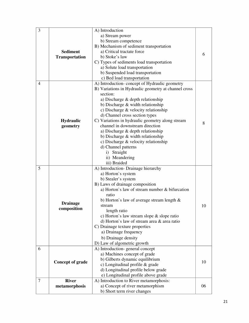
3
Sediment
Transportation
A) Introduction
a) Stream power
b) Stream competence
B) Mechanism of sediment transportation
a) Critical tractate force
b) Stoke’s law
C) Types of sediments load transportation
a) Solute load transportation
b) Suspended load transportation
c) Bed load transportation
6
4
Hydraulic
geometry
A) Introduction- concept of Hydraulic geometry
B) Variations in Hydraulic geometry at channel cross
section:
a) Discharge & depth relationship
b) Discharge & width relationship
c) Discharge & velocity relationship
d) Channel cross section types
C) Variations in hydraulic geometry along stream
channel in downstream direction
a) Discharge & depth relationship
b) Discharge & width relationship
c) Discharge & velocity relationship
d) Channel patterns
i) Straight
ii) Meandering
iii) Braided
8
5
Drainage
composition
A) Introduction- Drainage hierarchy
a) Horton`s system
b) Stealer`s system
B) Laws of drainage composition
a) Horton`s law of stream number & bifurcation
ratio
b) Horton`s law of average stream length &
stream
length ratio
c) Horton`s law stream slope & slope ratio
d) Horton`s law of stream area & area ratio
C) Drainage texture properties
a) Drainage frequency
b) Drainage density
D) Law of algometric growth
10
6
Concept of grade
A) Introduction- general concept
a) Machines concept of grade
b) Gilberts dynamic equilibrium
c) Longitudinal profile & grade
d) Longitudinal profile below grade
e) Longitudinal profile above grade
10
7 River
metamorphosis
A) Introduction to River metamorphosis:
a) Concept of river metamorphism
b) Short term river changes
06
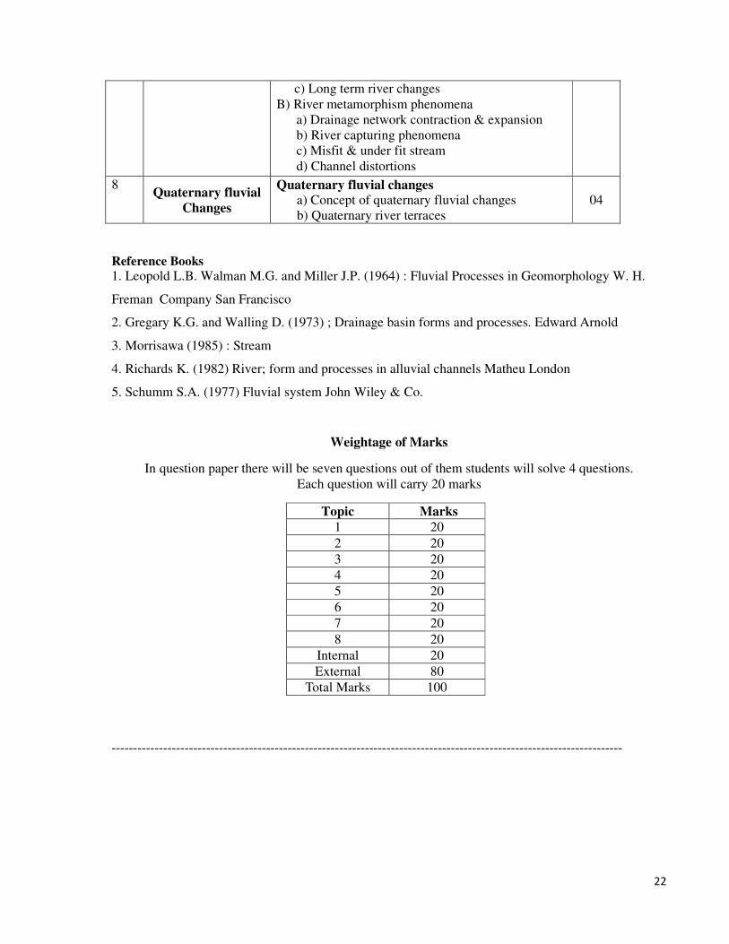
22
c) Long term river changes
B) River metamorphism phenomena
a) Drainage network contraction & expansion
b) River capturing phenomena
c) Misfit & under fit stream
d) Channel distortions
8 Quaternary fluvial
Changes
Quaternary fluvial changes a) Concept of quaternary fluvial changes
b) Quaternary river terraces
04
Reference Books
1. Leopold L.B. Walman M.G. and Miller J.P. (1964) : Fluvial Processes in Geomorphology W. H.
Freman Company San Francisco
2. Gregary K.G. and Walling D. (1973) ; Drainage basin forms and processes. Edward Arnold
3. Morrisawa (1985) : Stream
4. Richards K. (1982) River; form and processes in alluvial channels Matheu London
5. Schumm S.A. (1977) Fluvial system John Wiley & Co.
Weightage of Marks
In question paper there will be seven questions out of them students will solve 4 questions.
Each question will carry 20 marks
Topic Marks
1 20
2 20
3 20
4 20
5 20
6 20
7 20
8 20
Internal 20
External 80
Total Marks 100
-----------------------------------------------------------------------------------------------------------------------
23
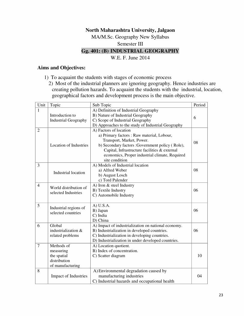
North Maharashtra University, Jalgaon
MA/M.Sc. Geography New Syllabus
Semester III
Gg. 401: (B) INDUSTRIAL GEOGRAPHY W.E. F. June 2014
Aims and Objectives:
1) To acquaint the students with stages of economic process
2) Most of the industrial planners are ignoring geography. Hence industries are
creating pollution hazards. To acquaint the students with the industrial, location,
geographical factors and development process is the main objective.
Unit Topic Sub Topic Period
1 Introduction to
Industrial Geography
A) Definition of Industrial Geography
B) Nature of Industrial Geography
C) Scope of Industrial Geography
D) Approaches to the study of Industrial Geography
6
2
Location of Industries
A) Factors of location
a) Primary factors : Raw material, Lobour,
Transport, Market, Power.
b) Secondary factors :Government policy ( Role),
Capital, Infrastructure facilities & external
economics, Proper industrial climate, Required
site condition
08
3
Industrial location
A) Models of Industrial location
a) Alfred Weber
b) August Losch
c) Tord Palender
08
4 World distribution of
selected Industries
A) Iron & steel Industry
B) Textile Industry
C) Automobile Industry
06
5 Industrial regions of
selected countries
A) U.S.A.
B) Japan
C) India
D) China
06
6 Global
industrialization &
related problems
A) Impact of industrialization on national economy.
B) Industrialization in developed countries.
C) Industrialization in developing countries.
D) Industrialization in under developed countries.
06
7 Methods of
measuring
the spatial
distribution
of manufacturing
A) Location quotient.
B) Index of concentration.
C) Scatter diagram 10
8
Impact of Industries
A) Environmental degradation caused by
manufacturing industries
C) Industrial hazards and occupational health
04

24
D) Impact of manufacturing industries on economic
development.
E) Shifting of industries and its impact on the urban
fringe
F) Role of globalization on manufacturing sector.
Weightage of Marks
In question paper there will be seven questions out of them students will solve 4 questions.
Each question will carry 20 marks
Topic Marks
1 20
2 20
3 20
4 20
5 20
6 20
7 20
8 20
Internal 20
External 80
Total Marks 100
Reference Books
1. Mather J.R. : Climatology (1974) , Fundamentals and Application. Mc Graw Hill New York
2. Hobbs, John E ( 1980) : Applied Climatology, Dawson West View Press.
3. Oliver, John E. (1973) : Climate and Mavis Environment, John Wiley and Sons, New York.
4. Geiger, Rudolf, (1966) : The climate near the Ground, Hardward University Press.
5. Lal M.(ed.) (1981) : Climatology, Selected Application, V .H. Winston and Sons, London.
5. Alexander, J.W. Economic Geography, Prentice Hall, Englewood Cliffs, 1988.
6. Alexanderson, C.: Geography of Manufacturing, Prentice Hall, Bombay, 1967.
7. Hoover, E.M.: The Location and Space Economy, McGraw Hill, New York 1948.
8. Isard, W.: Methods of Regional Analysis, The Technology Press of M.I.T. & John Wiley & Sons,
New York 1956.
9. Miller, E.: A Geography of Manufacturing, Prentice Hall, Englewood Cliffs, New Jersey, 1962.
10. Weber, Alfred, Theory of Location of Industries, Chicago University Press, Chicago, 1957.
11. Goh Cheng Leong (1997)."Human and economic geography",Oxford Uni. Press, New York.
12. Truman, A. Harishorn, John W. Alexander (2000) “Economic Geography", Prentice Hall of India
Ltd., New Delhi.
13. Thoman, R.S., Conkling E.C. and Yeates, M.H. (1968). Geography of Economic Activity,
McGraw Hill Book Company, 1968.
********************************************************************

25
North Maharashtra University, Jalgaon
MA/M.Sc. Geography New Syllabus
Semester III
Gg. 401 (C) : GEOGRAPHY OF RURAL SETTLEMENTS W.E. F. June 2014
Unit.
No.
Topic Sub-topics Periods
1 Introduction to
Settlement
Geography
A) Definition and Evolution of settlements: 1 Definition in different parts of the world
2 Sequence of occupancy from Neolithic
3. Modern periods.
B) Place names: 1. Historical
2. Cultural and Geographical aspects of settlements
reflected in place names.
06
2 Growth and
Distribution A) Site, Situation &Location: 1. Various factors affecting settlement site and
distribution
2. Depression and nucleation, factors affecting
dispersion and nucleation- Methods of the
measuring degree of dispersion.
B) Growth of Settlements:
1. Factors affecting growth of settlements-
2.System of land division, water rights system of
agriculture, land tenancy system
06
3 Theories of
Rural Land
Use
A) Factors Affecting
1.Intensity of Land use
2. Labour cost
3. Marketing of product
B) Theories:
1.Von Thunen
2. Ricardo
08
4 Rural
Economic
Activities
Rural Service Centers: 1.Functional analysis of service village and Trading
Center
2. Centrality and Hierarchy of Rural Service centers
3. Central Place Theory
06
5 Morphogenesis
of Rural
Settlements
and
A) Morphogenesis
1. Social
2. Cultural
06

26
Transformation 3. Economic organization within villages.
B) Functional growth 1. Functional growth
2. Socio-economic transformation in rural areas.
6
Demographic
Characteristics
of Rural
Settlement
A) Demographic aspects
1. Age-Sex, Education, Occupation, Caste
B) Migration: 1. Causes & Consequence of migration in rural areas
2. Seasonal migration.
3. Commuting patterns
12
7 Rural House
Types
&
Rural
Settlements in
Maharashtra
A) Rural House Types:
Analysis of rural House Types:
1. Primitive, Vernacular and Modern high rise
2. Physical, Social, Cultural and Economic
factors affecting rural house types.
3. Size, functional use and architectural style.
4. Building material
B) Rural Settlements in Maharashtra: 1. Various patterns
2. House types and Settlement patterns in
Maharashtra
10
8 Rural
Development
Planning
Various Aspects of Rural Planning:
1. Landuse
2. Transport
3. Amenities
4. Population
5. Environment
06

27
Weightage of Marks
In question paper there will be seven questions out of them students will solve 4 questions.
Each question will carry 20 marks
Topic Marks
1 20
2 20
3 20
4 20
5 20
6 20
7 20
8 20
Internal 20
External 80
Total Marks 100
******************************************************************
28
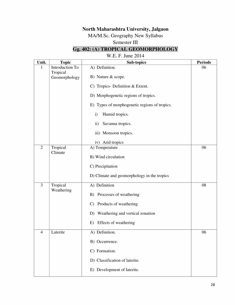
North Maharashtra University, Jalgaon
MA/M.Sc. Geography New Syllabus
Semester III
Gg. 402: (A) TROPICAL GEOMORPHOLOGY
W.E. F. June 2014
Unit. Topic Sub-topics Periods
1 Introduction To
Tropical
Geomorphology
A) Definition.
B) Nature & scope.
C) Tropics- Definition & Extent.
D) Morphogenetic regions of tropics.
E) Types of morphogenetic regions of tropics.
i) Humid tropics.
ii) Savanna tropics.
iii) Monsoon tropics.
iv) Arid tropics
06
2 Tropical
Climate
A) Temperature
B) Wind circulation
C) Precipitation
D) Climate and geomorphology in the tropics
06
3 Tropical
Weathering
A) Definition
B) Processes of weathering
C) Products of weathering
D) Weathering and vertical zonation
E) Effects of weathering
08
4 Laterite A) Definition.
B) Occurrence.
C) Formation.
D) Classification of laterite.
E) Development of laterite.
06

29
F) Laterite profile on granite basalt.
G) Truncated.
H) Non-truncated.
5 Tropical
Denudation
A) Introduction- concept.
B) Erosion from tropical rainfall.
C) Mass movements
06
6
Tropical
Deposition
A) Introduction.
B) Fluvial depositional environment
C) The channel alluvium
D) Floodplain
E) Tropical delta.
12
7 Tropical
Landforms
A) Introduction.
B) Tropical escarpments & pediments.
C) Tropical tors & domes.
D) Definition.
E) Occurrence.
F) Morphology.
G) Formation.
H) Types.
10
8 Tropical
Planations
A) Etchplains
B) Peneplains
C) Pediplains
Occurrence, Distribution, Morphology, Origin
06
Weightage of Marks
In question paper there will be seven questions out of them students will solve 4 questions.
Each question will carry 20 marks
Topic
Marks
30
1 20
2 20
3 20
4 20
5 20
6 20
7 20
8 20
Internal 20
External 80
Total Marks 100
Reference Books 1. Michael F.Thomas (1974) : Tropical Geomorphology, Mc Milan.
2. Douglas I. & Spanser (1985) : Environmental changes and Tropical Geomorphology, George Allen and
Unwin, London.
3. Faniran A and Teje L.K. (1983) : Humid Tropical Geomorphology, Longman London.
4. Tricart J. (1972) : Landforms in Humid Tropics , Forest and Savannas , Longman London.
5. Sharma H.S. (1969) : Tropical Geomorphology, UNESCO Paris.
*******************************************************************
North Maharashtra University, Jalgaon
MA/M.Sc. Geography New Syllabus
Semester III
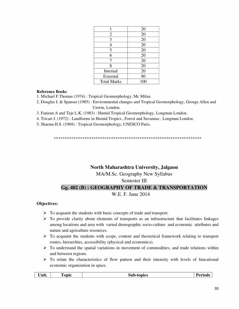
Gg. 402 (B) : GEOGRAPHY OF TRADE & TRANSPORTATION W.E. F. June 2014
Objectives:
� To acquaint the students with basic concepts of trade and transport.
� To provide clarity about elements of transports as an infrastructure that facilitates linkages
among locations and area with varied demographic socio-culture and economic attributes and
nature and agriculture resources.
� To acquaint the students with scope, content and theoretical framework relating to transport
routes, hierarchies, accessibility (physical and economics).
� To understand the spatial variations in movement of commodities, and trade relations within
and between regions.
� To relate the characteristics of flow pattern and their intensity with levels of funcational
economic organization in space.
Unit. Topic Sub-topics Periods
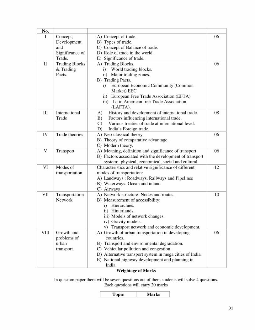
31
No.
I Concept,
Development
and
Significance of
Trade.
A) Concept of trade.
B) Types of trade.
C) Concept of Balance of trade.
D) Role of trade in the world.
E) Significance of trade.
06
II Trading Blocks
& Trading
Pacts.
A) Trading Blocks.
i) World trading blocks.
ii) Major trading zones.
B) Trading Pacts.
i) European Economic Community (Common
Market) EEC
ii) European Free Trade Association (EFTA)
iii) Latin American free Trade Association
(LAFTA).
06
III International
Trade
A) History and development of international trade.
B) Factors influencing international trade.
C) Various treaties of trade at international level.
D) India’s Foreign trade.
08
IV Trade theories A) Neo-classical theory.
B) Theory of comparative advantage.
C) Modern theory.
06
V Transport A) Meaning, definition and significance of transport
B) Factors associated with the development of transport
system: physical, economical, social and cultural.
06
VI
Modes of
transportation
Characteristics and relative significance of different
modes of transportation:
A) Landways : Roadways, Railways and Pipelines
B) Waterways: Ocean and inland
C) Airways
12
VII Transportation
Network
A) Network structure: Nodes and routes.
B) Measurement of accessibility:
i) Hierarchies.
ii) Hinterlands.
iii) Models of network changes.
iv) Gravity models.
v) Transport network and economic development.
10
VIII Growth and
problems of
urban
transport.
A) Growth of urban transportation in developing
countries.
B) Transport and environmental degradation.
C) Vehicular pollution and congestion.
D) Alternative transport system in mega cities of India.
E) National highway development and planning in
India.
06
Weightage of Marks
In question paper there will be seven questions out of them students will solve 4 questions.
Each questions will carry 20 marks
Topic Marks

32
1 20
2 20
3 20
4 20
5 20
6 20
7 20
8 20
Internal 20
External 80
Total Marks 100
Reference Books:
1. Taffe, E.J and Gauthier H.L (1973): Geography of Transportation, Prentice-Hall
2. Majid Husain (1994): Transport Geography, Anmol Publication Pvt. Ltd. New Delhi.
3. O’Dell and Richards (1968): Railways and Geography
4. Sealy(1968): Geography of Air Transportation. Hutchinson University
5. Thoman and Conking: Geography of International Trade.
6. Singh K N (1990): Transport network in Rural Development, Institute of Rural Economic
Development, Varanasi.
7. Thoman , Gonkling, Vegles(1974): Geography of Economics Activity.
8. Tolley R.S and Turton B.J. (1989): Transport system, Policy and Planning, Longman Group,
Singapore
9. White H.P. and Senior M.L. (1989): Transport Geography, Longman Group, Singapore
10. Bhandari S (1992): Transport and Regional Development, Concept Publication, New Delhi
11. Pande (1991): Transport Geography, Concept Publication, New Delhi
12. Vaidya B C (eds) (1998): Reading in Transport Geography: A Regional Perspective , Devika
Publication, New Delhi.
13. Saxena, H.M. : Transport Geography.
*************************************************************
North Maharashtra University, Jalgaon
MA/M.Sc. Geography New Syllabus
Semester III
Gg. 402 (C) : URBAN GEOGRAPHY W.E. F. June 2014
Objectives:
� To develop awareness among the students about the data sources and their application to
understand and evaluate the spatial patterns and processes of urbanization.
� To encourage the students to study the urban morphology and urban functions with special
reference to India.

33
� To understand the evolution of urban settlements with relevant theories and models.
� To study the fundamental concepts of urban settlement.
� To examine the contemporary urban issues and suggest remedial measures on them.
� To acquire the knowledge about the planned cities in India.
Unit.
No.
Topic Sub-topics Periods
I Introduction to
Urban
Geography
A) Meaning and definitions by various geographers
B) Nature and scope
C) Relation to other disciplines
D) Significance
E) Contributions of Indian scholars to the study of urban
geography
06
II Urbanization A) Meaning of urban settlements and urbanization
B) Criteria used to distinguish urban settlements
C) Process of urbanization
D) Factors influencing urbanization
E) Trends of urbanization in India
06
III Urban
morphology
A) Morphology of the city
a) Definition
b) The city core
c) Integument
d) Enclaves
e) Kernel
f) Characteristics and demarcation of CBD.
B) Morphology of Indian towns
C) Models of urban structure
a) Concentric zone model – E.W. Burgess.
b) Sector model – Homer Hoyt.
c) Multiple nuclei model – Harris and Ullman
08
IV Urban
classification
A) Various approaches to classification
B) Urban functions
C) Functional classification of towns and cities by C.D.
Harris and H.J.Nelson
06
V Rural-Urban
fringe
A) Meaning of rural-urban fringe
B) Characteristics of rural-urban fringe
C) Suburbanization
D) Concepts of Conurbation, Megapolis, Satellite Towns
06
VI
City and its
region
A) Concept of city region and various synonyms terms used
B) Criteria used to demarcate the city region
C) The nature of urban influence
12
VII Contemporary
urban issues
A) Urban issues
a) Price land vertical and horizontal growth of cities
b) Urban Sprawl
c) Scarcity of housing and growth of slums
d) Problems of civic amenities
e) Urban transport problem
f) Environmental pollution
10
34
g) Urban poverty
h) Urban crime
i) Issues of environmental health
j) Urban renewal
B) Remedial measures to solve the urban problems.
VIII Urban
Planning
A) Need of urban planning
B) Elements of city plan
C) Master plan of towns:Meaning and need of master plans
D) Planned cities in India
E) The study of the following planned cities – Chandigarh,
Jamshedpur & Lavasa
06
Weightage of Marks
In question paper there will be seven questions out of them students will solve 4 questions.
Each question will carry 20 marks
Topic Marks
1 20
2 20
3 20
4 20
5 20
6 20
7 20
8 20
Internal 20
External 80
Total Marks 100
Reference Books:
1. Bose Ashsh: India’s Urbanization 1901 to 2001-Tata Mcgraw Hill Publishing Co. New Delhi.
2. Chopara Girish (2006): Urban Geography , Comman Wealth Publishing Co.New Delhi.
3. Dikenson R.F: City and Region , Routledge and Kegan Paul Ltd. London.
4. Hudson F.S.: Geography of Settlement ,
5. Jonson J.M.: Urban Geography, Pergaman International Library. Pergaman Press.
6. K.Siddhartha and S.Mukarjee (2000) : Cities Urbanization and Urban Systems, Kisalaya
Publication New Delhi.
7. Mayer Harold H. and Kohn clyde F. : Reading in Urban Geography , Central Book Depot. Allahabad.
8. Misra R.P. (ed.): Contribution to Indian Geography, Urban Geography; Haritage Publishing Co.
New Delhi.
9. V.L.S. Prakash Rao: Urbanization in India , Concept Publishing New Delhi.
10. Sawant S.B: The City of Poona , University of Pune.
11. Taylor Griffith: Urban Geography , Methhen & Co. Ltd. London.
12. Mandal R.B. (2000): Urban Geography, A Textbook , Concept Publishing New Delhi.
13.Majid Husain(1994) : Urban Geography, Anmol Publications PVT. LTD. New Delhi.
17. Singh K and Steinberg F. (eds.) : Urban India in Crisis, New Age Interns, New Delhi, 1998.
19. Tewari, Vinod K, Jay A. Weinstein, VLS Prakasa Rao (editors) Indian Cities: Ecological
Perspectives Concept 1986
35
*****************************************************************************
North Maharashtra University, Jalgaon
MA/M.Sc. Geography New Syllabus
Semester III
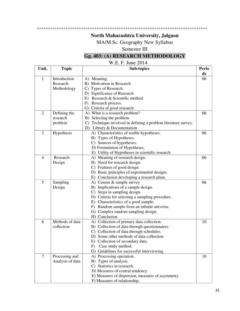
Gg. 403: (A) RESEARCH METHODOLOGY W.E. F. June 2014
Unit. Topic Sub-topics Perio
ds
1 Introduction
Research
Methodology
A) Meaning.
B) Motivation in Research
C) Types of Research.
D) Significance of Research
E) Research & Scientific method.
F) Research process.
G) Criteria of good research
06
2 Defining the
research
problem
A) What is a research problem?
B) Selecting the problem.
C) Technique involved in defining a problem literature survey.
D) Library & Documentation
06
3 Hypothesis A) Characteristics of usable hypotheses.
B) Types of Hypotheses.
C) Sources of hypotheses.
D) Formulation of Hypotheses.
E) Utility of Hypotheses in scientific research
06
4 Research
Design A) Meaning of research design.
B) Need for research design.
C) Features of good design.
D) Basic principles of experimental designs.
E) Conclusion developing a research plain.
06
5 Sampling
Design A) Census & sample survey
B) Implications of a sample design.
C) Steps in sampling design.
D) Criteria for selecting a sampling procedure.
E) Characteristics of a good sample.
F) Random sample from an infinite universe.
G) Complex random sampling design.
H) Conclusion
06
6
Methods of data
collection
A) Collection of primary data collection.
B) Collection of data through questionnaires.
C) Collection of data through schedules.
D) Some other methods of data collection.
E) Collection of secondary data.
F) Case study method.
G) Guidelines for successful interviewing
10
7 Processing and
Analysis of data
A) Processing operation.
B) Types of analysis.
C) Statistics in research.
D) Measures of central tendency.
E) Measures of dispersion, measures of asymmetry.
F) Measures of relationship.
10
36
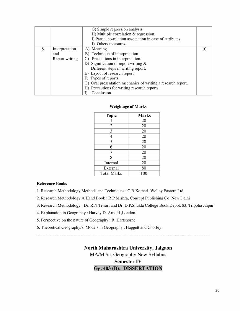
G) Simple regression analysis.
H) Multiple correlation & regression.
I) Partial co-relation association in case of attributes.
J) Others measures.
8 Interpretation
and
Report writing
A) Meaning.
B) Technique of interpretation.
C) Precautions in interpretation.
D) Signification of report writing &
Different steps in writing report.
E) Layout of research report
F) Types of reports.
G) Oral presentation mechanics of writing a research report.
H) Precautions for writing research reports.
I) Conclusion.
10
Weightage of Marks
Topic Marks
1 20
2 20
3 20
4 20
5 20
6 20
7 20
8 20
Internal 20
External 80
Total Marks 100
Reference Books
1. Research Methodology Methods and Techniques : C.R.Kothari, Welley Eastern Ltd.
2. Research Methodology A Hand Book : R.P.Mishra, Concept Publishing Co. New Delhi
3. Research Methodology : Dr. R.N.Tiwari and Dr. D.P.Shukla College Book Depot. 83, Tripolia Jaipur.
4. Explanation in Geography : Harvey D. Arnold ,London.
5. Perspective on the nature of Geography : R. Hartshorne.
6. Theoretical Geography.7. Models in Geography ; Haggett and Chorley --------------------------------------------------------------------------------------------------------------------------
North Maharashtra University, Jalgaon
MA/M.Sc. Geography New Syllabus
Semester IV
Gg. 403 (B): DISSERTATION
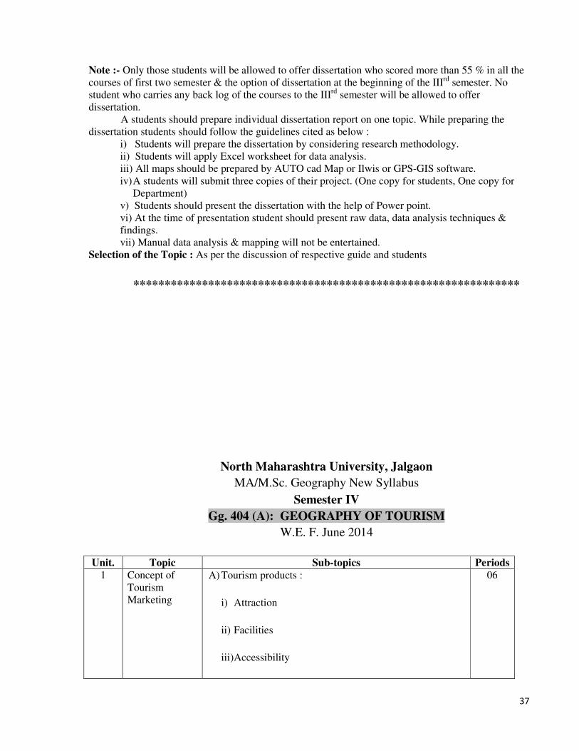
37
Note :- Only those students will be allowed to offer dissertation who scored more than 55 % in all the
courses of first two semester & the option of dissertation at the beginning of the IIIrd
semester. No
student who carries any back log of the courses to the IIIrd
semester will be allowed to offer
dissertation.
A students should prepare individual dissertation report on one topic. While preparing the
dissertation students should follow the guidelines cited as below :
i) Students will prepare the dissertation by considering research methodology.
ii) Students will apply Excel worksheet for data analysis.
iii) All maps should be prepared by AUTO cad Map or Ilwis or GPS-GIS software.
iv) A students will submit three copies of their project. (One copy for students, One copy for
Department)
v) Students should present the dissertation with the help of Power point.
vi) At the time of presentation student should present raw data, data analysis techniques &
findings.
vii) Manual data analysis & mapping will not be entertained.
Selection of the Topic : As per the discussion of respective guide and students
**************************************************************
North Maharashtra University, Jalgaon
MA/M.Sc. Geography New Syllabus
Semester IV
Gg. 404 (A): GEOGRAPHY OF TOURISM W.E. F. June 2014
Unit. Topic Sub-topics Periods
1 Concept of
Tourism
Marketing
A) Tourism products :
i) Attraction
ii) Facilities
iii) Accessibility
06

38
iv) Marketing characteristics
B) Types of Tourism Marketing: Vocational Tourism,
Business Tourism Common Interest tourism.
2 Functions of
Tourism
Marketing
i) Marketing Research
ii) Advertisement
iii) Sales supports
iv) Public Relations Tourism Publications.
06
3 Impacts of
Tourism
A) Economics Impacts :
i) Effects on foreign exchange,
ii) Employment generation
iii) Increase in Trading activities
iv) Inflation of Land values
v) Increase in revenue
vi) concept of Economics multiplier, Investment
06
4 Socio-cultural
and
Environmental
Impacts
A) Neocolonialism
B) Crime & Gambling activities
C) Impact on Religion, Language and Health
D) Tourism and cultural changes.
E) Impact of Tourism on Environment.
06
5 Tourism
Planning
A) Types of Tourism planning
B) Problems of Tourism planning.
C) Tourism planning in developed and developing
countries.
D) Components of Tourism planning
E) Programme implementation.
06

39
F) Evaluation of National Tourism attraction.
G) Infrastructural facilities.
H) Model of Tourism planning.
6 Role of Travel
Agency in
Tourism
A) Thomas cook, The American Express Co. Cox and
kings.
B) Modern Travel Agencies and their operations.
10
7 Travel
organizations
ASTA, UFTAA, Travel Agents in India, TAAI, ITDC,
MTDC
10
8 Role of Indian
Railways
Role of Indian Railways in the growth of Tour Business.
Growth, Importance and characteristics of Indian Railways
10
In question paper there will be seven questions out of them students will solve 4 questions.
Each questions will carry 20 marks
Topic Marks
1 20
2 20
3 20
4 20
5 20
6 20
7 20
8 20
Internal 20
External 80
Total Marks 100
Recommended Books
1. Heritage Tourism Development- Romila Chawala
2. Development of Tourism in India- H.L.P. Rai
3. Tourism Development- A.K. Bhatia
4. International Tourism- A.K. Bhatia
5. Tourism Development- A.K. Bhatia
6. Development of Tourism in India- H.L.P. Rai
7. Tourism and Economic Growth and Development- P.A. Agarwal
8. Economics of Tourism Development- Romila Chawala
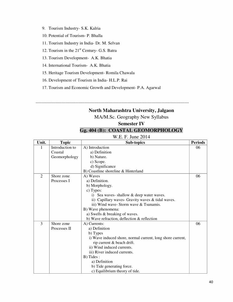
40
9. Tourism Industry- S.K. Kalria
10. Potential of Tourism- P. Bhalla
11. Tourism Industry in India- Dr. M. Selvan
12. Tourism in the 21st Century- G.S. Batra
13. Tourism Development- A.K. Bhatia
14. International Tourism- A.K. Bhatia
15. Heritage Tourism Development- Romila Chawala
16. Development of Tourism in India- H.L.P. Rai
17. Tourism and Economic Growth and Development- P.A. Agarwal
-----------------------------------------------------------------------------------------------------------
North Maharashtra University, Jalgaon
MA/M.Sc. Geography New Syllabus
Semester IV
Gg. 404 (B): COASTAL GEOMORPHOLOGY W.E. F. June 2014
Unit. Topic Sub-topics Periods
1 Introduction to
Coastal
Geomorphology
A) Introduction
a) Definition
b) Nature.
c) Scope.
d) Significance
B) Coastline shoreline & Hinterland
06
2 Shore zone
Processes I A) Waves
a) Definition.
b) Morphology.
c) Types:
i) Sea waves- shallow & deep water waves.
ii) Capillary waves- Gravity waves & tidal waves.
iii) Wind wave- Storm wave & Tsunamis.
B) Wave phenomena:
a) Swells & breaking of waves.
b) Wave refraction, deflection & reflection
06
3 Shore zone
Processes II A) Currents:
a) Definition
b) Types
i) Wave induced shore, normal current, long shore current,
rip current & beach drift.
ii) Wind induced currents.
iii) River induced currents.
B) Tides :
a) Definition
b) Tide generating force.
c) Equilibrium theory of tide.
06

41
d) Types of tides.
i) Diurnal & semidiurnal.
ii) Spring & neap tide.
4 Shore line
changes A) Concept of shoreline changes.
B) Quaternary eustatic changes.
a) Evidences. (b) causes. (c) effects
06
5 Coastal
erosional
process &
landforms
A) Concept of coastal erosion.
B) Processes of coastal erosion.
C) Landforms of coastal erosion.
a) Sea cliff & shore platform.
b) Caves, arches & stacks.
c) Geos & blow holes.
06
6 Coastal
depositional
processes &
landforms
A) Concept of coastal deposition.
B) Processes of coastal deposition.
C) Landforms of coastal deposition.
a) Beaches.
b) Spits bars & barrier islands.
c) Sand dunes.
d) Mangroves, shamps & salt marshes.
e) Estuaries & deltas.
10
7 Coastal
sediments A) Sources of coastal sediments.
B) Types.
a) Terrigenous.
b) Pelagic.
c) Volcanic.
d) Meteoric.
C) Coral reef.
a) Definitions.
b) Favourable conditions for the formation.
c) Formation – daily & Murray’s theory.
d) Types of coral reef.
i) Fringing reef.
ii) Barrier reef.
iii) Atol
10
8 Classification of
the coast &
shore
line
A) Bases of classification.
B) Types & characteristics & examples.
a) Submergence.
b) Emergence.
c) Neutral.
10
Reference Books:
1. Pethic John (1984) : An Introduction to coastal geomorphology, Arnold Heinemann,London.
2. Ahmed E. (1973) : Coastal Geomorphology of India , Orient Longman, Mumbai.
3. Bird E.C.( 2000) : Coastal Geomorphology an Introduction ,John Wiley & Sons. Chicfester.
4. Karlekar S.N> (1993) : Coastal Geomorphology of Konkan, Aparna Publication Pune. 411037.
Weightage of Marks
42
In question paper there will be seven questions out of them students will solve 4 questions.
Each questions will carry 20 marks
Topic Marks
1 20
2 20
3 20
4 20
5 20
6 20
7 20
8 20
Internal 20
External 80
Total Marks 100
------------------------------------------------------------------------------ North Maharashtra University, Jalgaon
MA/M.Sc. Geography New Syllabus
Semester IV
Gg. 404 (C): AGRICULTURAL GEOGRAPHY W.E. F. June 2014
Objectives:
� To familiarize the students with the fundamental concepts in agricultural geography.
� To examine the role of physical and non-physical determinants towards changing cropping
patterns, intensity, productivity, diversification and specialization.
� To acquaint the students with the application of various theories and models in agricultural
geography.
� To study the agricultural systems in different parts of the world.
� To discuss environmental, technological and social issues in agricultural sector with special
reference to India.
� To know the students the overall importance of agriculture in global perspective.
Unit.
No.
Topic Sub-topic Periods
I Introduction to
Agricultural
Geography
A) Definitions, nature and scope, significance and
development of agricultural geography.
B) Approaches to the study of agricultural geography.
i) Environmental approach.
ii) Regional approach.
iii) Commodity approach.
iv) Behavioural approach
v) System analysis approach
06
II Fundamental
Concepts
Fundamental concepts in agricultural geography – Meaning
and explanation.
A) Landuse
08
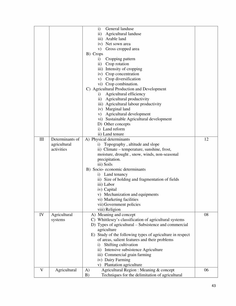
43
i) General landuse
ii) Agricultural landuse
iii) Arable land
iv) Net sown area
v) Gross cropped area
B) Crops
i) Cropping pattern
ii) Crop rotation
iii) Intensity of cropping
iv) Crop concentration
v) Crop diversification
vi) Crop combination.
C) Agricultural Production and Development
i) Agricultural efficiency
ii) Agricultural productivity
iii) Agricultural labour productivity
iv) Marginal land
v) Agricultural development
vi) Sustainable Agricultural development
D) Other concepts
i) Land reform
ii) Land tenure
III Determinants of
agricultural
activities
A) Physical determinants
i) Topography , altitude and slope
ii) Climate – temperature, sunshine, frost,
moisture, drought , snow, winds, non-seasonal
precipitation.
iii) Soils
B) Socio- economic determinants
i) Land tenancy
ii) Size of holding and fragmentation of fields
iii) Labor
iv) Capital
v) Mechanization and equipments
vi) Marketing facilities
vii) Government policies
viii) Religion
12
IV Agricultural
systems
A) Meaning and concept
C) Whittlesey’s classification of agricultural systems
D) Types of agricultural – Subsistence and commercial
agriculture
E) Study of the following types of agriculture in respect
of areas, salient features and their problems
i) Shifting cultivation
ii) Intensive subsistence Agriculture
iii) Commercial grain farming
iv) Dairy Farming
v) Plantation agriculture
08
V Agricultural A) Agricultural Region : Meaning & concept
B) Techniques for the delimitation of agricultural
06

44
Regionalization regions
i) Normative techniques
ii) Empirical techniques
iii) Single element techniques
iv) Statistical techniques
v) Complete multi-facet techniques
(Quantitative & qualitative)
C) Agricultural regions of India demarcated by Randhava
M.S.
VI
Modes in
Agricultural
Geography
A) Model : i) Meaning & Concept
ii) Significance of Agricultural models
iii) Limitations of Agricultural Models
B) Classification of agricultural models
i) Normative or Economic models
ii) Descriptive models
C) Von Thunen’s Models & its modifications
08
VII Agricultural
Statistics &
Land use Survey
techniques
A) Sources of agricultural statistics
i) Primary Sources of Agricultural data observation,
interview, questionnaire & schedule)
ii) Secondary Sources of agricultural data ( Indian
Agricultural Statistics, Agricultural seasons and crop
reports, crop statistics, irrigation statistics, agricultural
prices, World Agricultural Statistics & other statistics)
06
VIII Agrarian
Revolution
A) Meaning & Merit and Demerit of Green Revolution
B) Meaning & Merit and Demerit of White Revolution
06
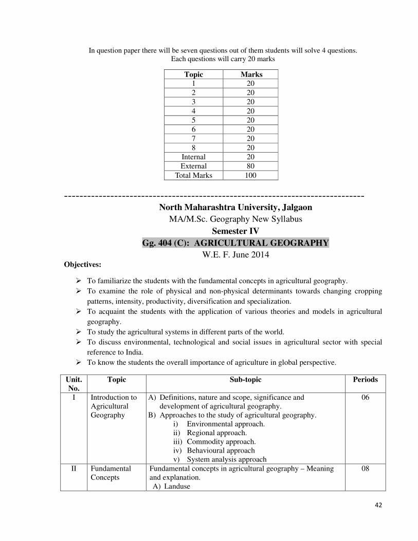
In question paper there will be seven questions out of them students will solve 4 questions.
Each questions will carry 20 marks
Topic Marks
1 20
2 20
3 20
4 20
5 20
6 20
7 20
8 20
Internal 20
External 80
Total Marks 100
Reference Books:
1 Symons, Leslie (1970) – Agricultural Geography, G. Belt and Sons Ltd, London.
2 Morgan. W.B. & S.C. Monton (1971) – Agricultural Geography Methuen , London.
3 Randhawa, M.S.(1980) – An History of Agriculture in India Vols. I,II,III,IV ICAR, New
Delhi.
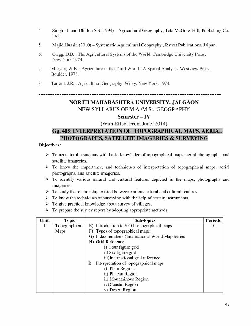
45
4 Singh . J. and Dhillon S.S (1994) – Agricultural Geography, Tata McGraw Hill, Publishing Co.
Ltd.
5 Majid Husain (2010) – Systematic Agricultural Geography , Rawat Publications, Jaipur.
6. Grigg, D.B. : The Agricultural Systems of the World. Cambridge University Press,
New York 1974.
7. Morgan, W.B. : Agriculture in the Third World - A Spatial Analysis. Westview Press,
Boulder, 1978.
8 Tarrant, J.R. : Agricultural Geography. Wiley, New York, 1974.
------------------------------------------------------------------------------- NORTH MAHARASHTRA UNIVERSITY, JALGAON
NEW SYLLABUS OF M.A./M.Sc. GEOGRAPHY
Semester – IV
(With Effect From June, 2014)
Gg. 405: INTERPRETATION OF TOPOGRAPHICAL MAPS, AERIAL
PHOTOGRAPHS, SATELLITE IMAGERIES & SURVEYING
Objectives:
� To acquaint the students with basic knowledge of topographical maps, aerial photographs, and
satellite imageries.
� To know the importance, and techniques of interpretation of topographical maps, aerial
photographs, and satellite imageries.
� To identify various natural and cultural features depicted in the maps, photographs and
imageries.
� To study the relationship existed between various natural and cultural features.
� To know the techniques of surveying with the help of certain instruments.
� To give practical knowledge about survey of villages.
� To prepare the survey report by adopting appropriate methods.
Unit. Topic Sub-topics Periods
I Topographical
Maps
E) Introduction to S.O.I topographical maps.
F) Types of topographical maps
G) Index numbers (International World Map Series
H) Grid Reference
i) Four figure grid
ii) Six figure grid
iii) International grid reference
I) Interpretation of topographical maps
i) Plain Region.
ii) Plateau Region
iii) Mountainous Region
iv) Coastal Region
v) Desert Region
10
46
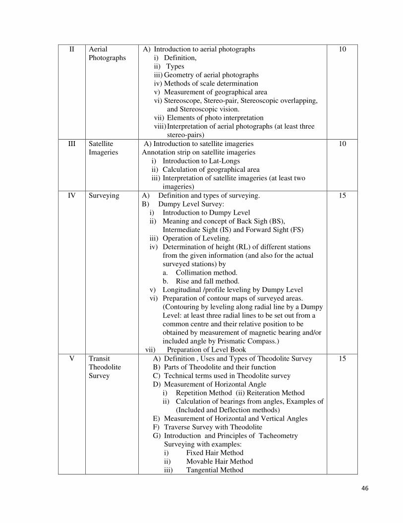
II Aerial
Photographs
A) Introduction to aerial photographs
i) Definition,
ii) Types
iii) Geometry of aerial photographs
iv) Methods of scale determination
v) Measurement of geographical area
vi) Stereoscope, Stereo-pair, Stereoscopic overlapping,
and Stereoscopic vision.
vii) Elements of photo interpretation
viii) Interpretation of aerial photographs (at least three
stereo-pairs)
10
III Satellite
Imageries
A) Introduction to satellite imageries
Annotation strip on satellite imageries
i) Introduction to Lat-Longs
ii) Calculation of geographical area
iii) Interpretation of satellite imageries (at least two
imageries)
10
IV Surveying A) Definition and types of surveying.
B) Dumpy Level Survey:
i) Introduction to Dumpy Level
ii) Meaning and concept of Back Sigh (BS),
Intermediate Sight (IS) and Forward Sight (FS)
iii) Operation of Leveling.
iv) Determination of height (RL) of different stations
from the given information (and also for the actual
surveyed stations) by
a. Collimation method.
b. Rise and fall method.
v) Longitudinal /profile leveling by Dumpy Level
vi) Preparation of contour maps of surveyed areas.
(Contouring by leveling along radial line by a Dumpy
Level: at least three radial lines to be set out from a
common centre and their relative position to be
obtained by measurement of magnetic bearing and/or
included angle by Prismatic Compass.)
vii) Preparation of Level Book
15
V Transit
Theodolite
Survey
A) Definition , Uses and Types of Theodolite Survey
B) Parts of Theodolite and their function
C) Technical terms used in Theodolite survey
D) Measurement of Horizontal Angle
i) Repetition Method (ii) Reiteration Method
ii) Calculation of bearings from angles, Examples of
(Included and Deflection methods)
E) Measurement of Horizontal and Vertical Angles
F) Traverse Survey with Theodolite
G) Introduction and Principles of Tacheometry
Surveying with examples:
i) Fixed Hair Method
ii) Movable Hair Method
iii) Tangential Method
15
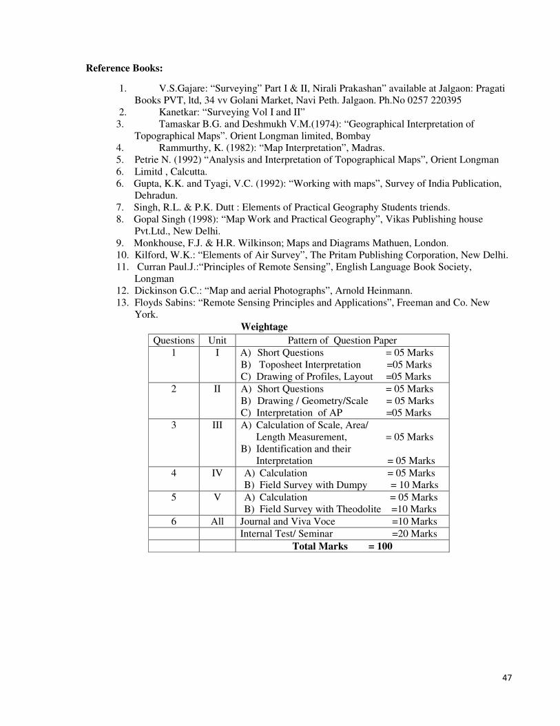
47
Reference Books:
1. V.S.Gajare: “Surveying” Part I & II, Nirali Prakashan” available at Jalgaon: Pragati
Books PVT, ltd, 34 vv Golani Market, Navi Peth. Jalgaon. Ph.No 0257 220395
2. Kanetkar: “Surveying Vol I and II”
3. Tamaskar B.G. and Deshmukh V.M.(1974): “Geographical Interpretation of
Topographical Maps”. Orient Longman limited, Bombay
4. Rammurthy, K. (1982): “Map Interpretation”, Madras.
5. Petrie N. (1992) “Analysis and Interpretation of Topographical Maps”, Orient Longman
6. Limitd , Calcutta.
6. Gupta, K.K. and Tyagi, V.C. (1992): “Working with maps”, Survey of India Publication,
Dehradun.
7. Singh, R.L. & P.K. Dutt : Elements of Practical Geography Students triends.
8. Gopal Singh (1998): “Map Work and Practical Geography”, Vikas Publishing house
Pvt.Ltd., New Delhi.
9. Monkhouse, F.J. & H.R. Wilkinson; Maps and Diagrams Mathuen, London.
10. Kilford, W.K.: “Elements of Air Survey”, The Pritam Publishing Corporation, New Delhi.
11. Curran Paul.J.:“Principles of Remote Sensing”, English Language Book Society,
Longman
12. Dickinson G.C.: “Map and aerial Photographs”, Arnold Heinmann.
13. Floyds Sabins: “Remote Sensing Principles and Applications”, Freeman and Co. New
York.
Weightage
Questions Unit Pattern of Question Paper
1 I A) Short Questions = 05 Marks
B) Toposheet Interpretation =05 Marks
C) Drawing of Profiles, Layout =05 Marks
2 II A) Short Questions = 05 Marks
B) Drawing / Geometry/Scale = 05 Marks
C) Interpretation of AP =05 Marks
3 III A) Calculation of Scale, Area/
Length Measurement, = 05 Marks
B) Identification and their
Interpretation = 05 Marks
4 IV A) Calculation = 05 Marks
B) Field Survey with Dumpy = 10 Marks
5 V A) Calculation = 05 Marks
B) Field Survey with Theodolite =10 Marks
6 All Journal and Viva Voce =10 Marks
Internal Test/ Seminar =20 Marks
Total Marks = 100