Embed Size (px)
Citation preview
AU/ACSC/MENARCHIK/AY10
AIR COMMAND AND STAFF COLLEGE
AIR UNIVERSITY
NORTH KOREAN PROTECTIVE MINE WARFARE:
AN ANALYSIS OF THE NAVAL MINEFIELDS AT WONSAN,
CHINNAMPO AND HUNGNAM DURING THE KOREAN WAR
by
Jason D. Menarchik, LCDR, USN
A Research Report Submitted to the Faculty
In Partial Fulfillment of the Graduation Requirements
Advisor: Dr Michael Allsep
Maxwell Air Force Base, Alabama
April 2010
Distribution A: Approved for public release; distribution unlimited
Report Documentation Page Form ApprovedOMB No. 0704-0188
Public reporting burden for the collection of information is estimated to average 1 hour per response, including the time for reviewing instructions, searching existing data sources, gathering andmaintaining the data needed, and completing and reviewing the collection of information. Send comments regarding this burden estimate or any other aspect of this collection of information,including suggestions for reducing this burden, to Washington Headquarters Services, Directorate for Information Operations and Reports, 1215 Jefferson Davis Highway, Suite 1204, ArlingtonVA 22202-4302. Respondents should be aware that notwithstanding any other provision of law, no person shall be subject to a penalty for failing to comply with a collection of information if itdoes not display a currently valid OMB control number.
1. REPORT DATE 01 APR 2010 2. REPORT TYPE
3. DATES COVERED 00-00-2010 to 00-00-2010
4. TITLE AND SUBTITLE NORTH KOREAN PROTECTIVE MINE WARFARE: AN ANALYSISOF THE NAVAL MINEFIELDS AT WONSAN, CHINNAMPO ANDHUNGNAM DURING THE KOREAN WAR
5a. CONTRACT NUMBER
5b. GRANT NUMBER
5c. PROGRAM ELEMENT NUMBER
6. AUTHOR(S) 5d. PROJECT NUMBER
5e. TASK NUMBER
5f. WORK UNIT NUMBER
7. PERFORMING ORGANIZATION NAME(S) AND ADDRESS(ES) Air Force Institute of Technology,2950 Hobson Way,WPAFB,OH,45433-7765
8. PERFORMING ORGANIZATIONREPORT NUMBER
9. SPONSORING/MONITORING AGENCY NAME(S) AND ADDRESS(ES) 10. SPONSOR/MONITOR’S ACRONYM(S)
11. SPONSOR/MONITOR’S REPORT NUMBER(S)
12. DISTRIBUTION/AVAILABILITY STATEMENT Approved for public release; distribution unlimited
13. SUPPLEMENTARY NOTES
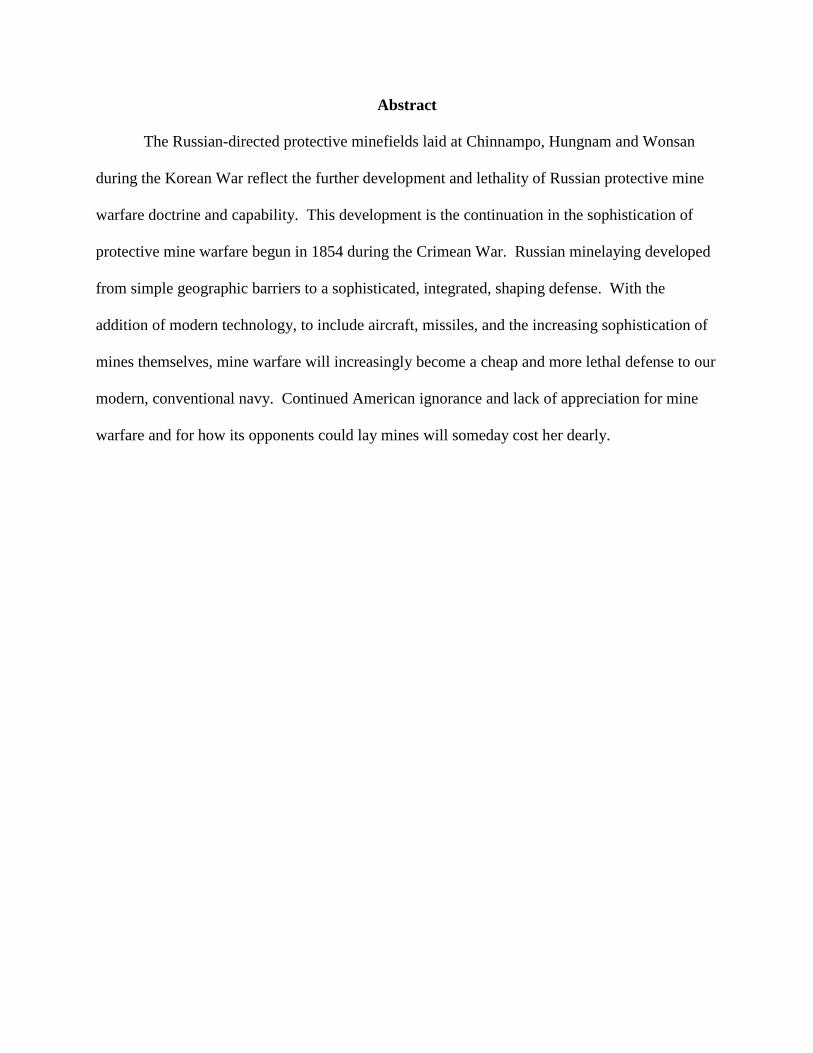
14. ABSTRACT The Russian-directed protective minefields laid at Chinnampo, Hungnam and Wonsan during the KoreanWar reflect the further development and lethality of Russian protective mine warfare doctrine andcapability. This development is the continuation in the sophistication of protective mine warfare begun in1854 during the Crimean War. Russian minelaying developed from simple geographic barriers to asophisticated, integrated, shaping defense. With the addition of modern technology, to include aircraft,missiles, and the increasing sophistication of mines themselves, mine warfare will increasingly become acheap and more lethal defense to our modern, conventional navy. Continued American ignorance and lackof appreciation for mine warfare and for how its opponents could lay mines will someday cost her dearly.
15. SUBJECT TERMS
16. SECURITY CLASSIFICATION OF: 17. LIMITATION OF ABSTRACT Same as
Report (SAR)
18. NUMBEROF PAGES
94
19a. NAME OFRESPONSIBLE PERSON
a. REPORT unclassified
b. ABSTRACT unclassified
c. THIS PAGE unclassified
Standard Form 298 (Rev. 8-98) Prescribed by ANSI Std Z39-18
Disclaimer
The views expressed in this academic research paper are those of the author and do not
reflect the official policy or position of the US government or the Department of Defense. In
accordance with Air Force Instruction 51-303, it is not copyrighted, but is the property of the
United States government.
Abstract
The Russian-directed protective minefields laid at Chinnampo, Hungnam and Wonsan
during the Korean War reflect the further development and lethality of Russian protective mine
warfare doctrine and capability. This development is the continuation in the sophistication of
protective mine warfare begun in 1854 during the Crimean War. Russian minelaying developed
from simple geographic barriers to a sophisticated, integrated, shaping defense. With the
addition of modern technology, to include aircraft, missiles, and the increasing sophistication of
mines themselves, mine warfare will increasingly become a cheap and more lethal defense to our
modern, conventional navy. Continued American ignorance and lack of appreciation for mine
warfare and for how its opponents could lay mines will someday cost her dearly.
AU/ACSC/MENARCHIK/AY10
4
Table of Contents
List of Figures …………………………………………………5
Introduction ……………………………………………………6
Korean War Overview ………………………..………8
Russian Role …………………………………..……...10
Part I: The Minefields …………………………………………12
The Mines ………………………………….……..…..12
The Minelayers ……………………………...………..13
Chinnampo …………………………………...……….14
Hungnam …………………………………...…………23
Wonsan ……………………………………...………...30
Part II: North Korean Minelaying Analysis …………………....48
Korean War Minefield Analysis …………...………….68
Part III: Extrapolating the North Korean Minelaying Effort …..74
Saint Petersburg ……………………………...………..79
Archangel ……………………………………...………86
Conclusion …………………………………....………..90
Appendix 1: The Sources
Bibliography
AU/ACSC/MENARCHIK/AY10
5
List of Figures
Figure 1: Primary North Korean Mine-Laying Areas …………9
Figure 2: Chinnampo Landmarks……………………………...20
Figure 3: Chinnampo Sweep ……………………………….....20
Figure 4: Chinnampo Port Entrance …………………………..21
Figure 5: Outer Defenses ……………………………………...21
Figure 6: Chinnampo ………………………………………….22
Figure 7: Chinnampo Sweep ………………………………….22
Figure 8: Hungnam Landmarks …………………………….…28
Figure 9: Hungnam Mine-Lines ………………………….........28
Figure 10: Hungnam Minesweeping …………………………..29
Figure 11: Hungnam Overlay ………………….………………29
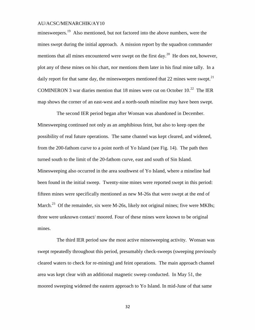
Figure 12: Wonsan Landmarks ………………………………..35
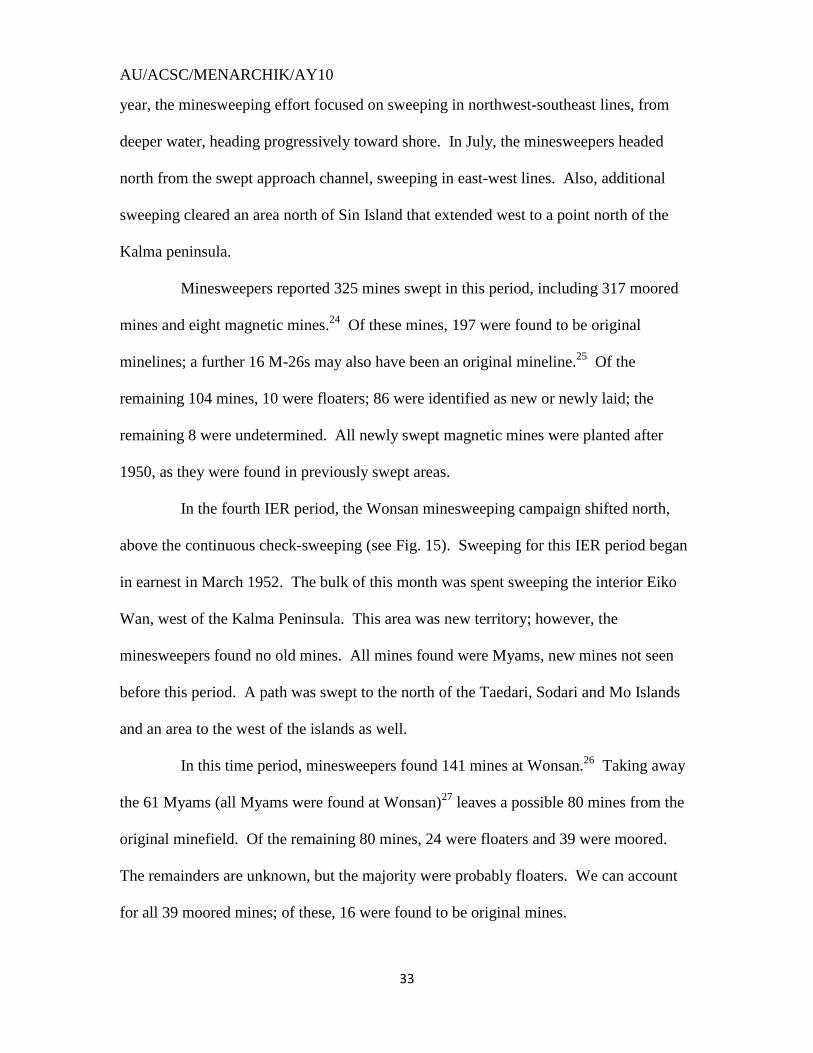
Figure 13: 1st Minesweeping …………………………………..35
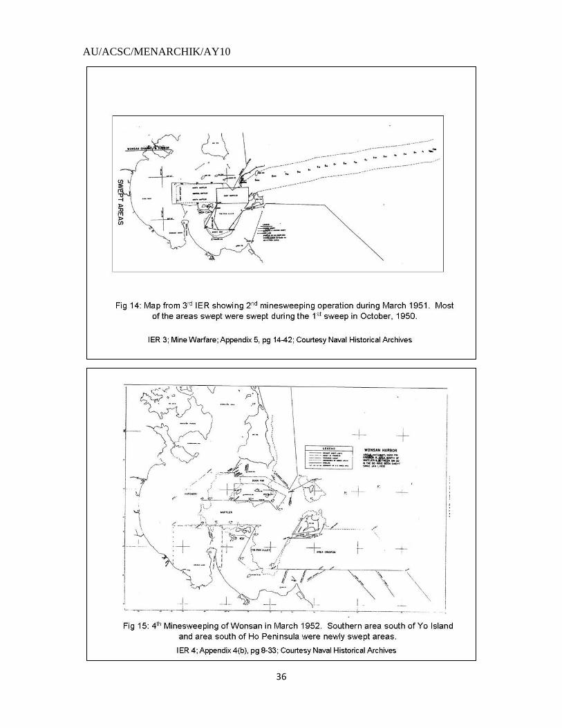
Figure 14: 2nd
Minesweeping ………………………………….36
Figure 15: 3rd
Minesweeping ……………………………….....36
Figure 16: 1st Minesweeping Overlay …………………………39
Figure 17: 2nd
Minesweeping Overlay ………………………...39
Figure 18: Wonsan Mine-Lines ……………………………….44
Figure 19: Wonsan Minelaying Planning ……………………..47
Figure 20: Port Arthur, 1904 …………………………………..66
Figure 21: First World War, 1917 ……………………………..66
Figure 22: German Island Attack, 1917 ……………………….67
Figure 23: British Intervention, 1919 ………………………….67
Figure 24: World War II, 1941 ………………………………...68
Figure 25: Soviet Minelaying Doctrine: Fewer Mines ………...69
Figure 26: Soviet Minelaying Doctrine: Numerous Mines ……73
Figure 27: Persian Gulf, 1991 …………………………………78
Figure 28: Baltic Sea: Many Mines ……………………………84
Figure 29: Gulf of Finland: Many Mines ………………………84
Figure 30: Baltic Sea: Fewer Mines ……………………………85
Figure 31: Gulf of Finland: Fewer Mines ……………………...85
Figure 32: Archangel: Many Mines ……………………………89
Figure 33: Archangel: Fewer Mines …………………………...89
AU/ACSC/MENARCHIK/AY10
6
North Korean Protective Mine Warfare
An Analysis of the Naval Minefields at Wonsan, Chinnampo and Hungnam during the
Korean War
“We have lost control of the seas to a nation without a Navy, using pre-World War I
weapons, laid by vessels that were utilized at the time of the birth of Christ.” – Admiral
Allan E. Smith1
Mine warfare historically has had low prestige inside the United States Navy
and the general military history community as well. As a result, studies involving mine
warfare have been neglected. In military history, mine warfare has been used to flavor
naval campaign stories, but only from the perspective of the minesweeper (or striker), not
from the minelayer. David Farragut and his famous “Damn the torpedoes” moment
during the Civil War is illustrative of this attitude. Mining is usually mentioned only
casually in historical campaign accounts, most often with references that expand little
beyond the fact that mines were present for that particular campaign. The Navy, lulled
into a sense of complacency, has neglected mine warfare studies. Naval Intelligence has
made little attempt to understand how adversaries would lay mines, with the information
available limited to „guestimates‟ and random speculation.
An additional byproduct (or cause) of this neglect is a lack of respect by the
Navy and Naval Intelligence for the potential of an extensive mining campaign against
US forces, an attitude encouraged by the fact that the US Navy has not faced an extensive
mining campaign against it. The American Navy‟s first significant naval encounter with
AU/ACSC/MENARCHIK/AY10
7
mines occurred during the Civil War, where, at the Battle of Mobile Bay, Admiral
Farragut famously ignored the mineline there to destroy the Confederate fleet nearby.
While extensive mining also occurred during World War One, the United States did not
encounter it, as the focus of the Central Powers mining campaigns occurred in the North,
Baltic, Black and Mediterranean Seas, well away from the American sea lines of
communications in the Atlantic and along the French coast. The Second World War also
saw extensive mining; however, the Americans laid most of the mines and were
infrequently the victim of them. The Navy did encounter mines during the Korean War,
where three large ports were cleared to advance UN sea lines of communications. These
minefields, however, were hastily planted as the Communists rushed to forestall
additional amphibious assaults after the surprise Inchon landing, or limited by the North
Koreans‟ lack of resources. Additionally, while the minefields in Korea were extensive
at the three large ports swept, only approximately 1,000 mines were swept there.
Hundreds of additional mines were encountered throughout the war, but only in
piecemeal fashion as part of a harassment campaign, and not as a part of an integrated
coastal defense. By comparison, in the narrow waters of the Gulf of Finland, Russians
laid 19,000 mines during the First World War to counter a feared German invasion.
Later, during World War Two, the Germans laid 14,000 mines there. Major powers
have used mine warfare in the recent past. The US has limited experience combating it,
but may face a major mine warfare threat in the near future. No interest and no
experience with extensive mine warfare puts the US in danger.
This paper intends to correct these deficiencies in the historical record and in
current understanding of potential threats by analyzing the most recent complex
AU/ACSC/MENARCHIK/AY10
8
minefields laid, those directed by the Russians during the Korean War, and deriving from
that experience aspects of Russian minelaying doctrine. Understanding the minefield at
Wonsan, in particular, is not immediately intuitive, and has caused some befuddlement in
understanding the minelaying thought process. To achieve this understanding, this paper
will use a three-part approach. The first part describes the three large minefields at
Wonsan, Hungnam and Chinnampo, using original research. The second part will
analyze these minefields in the context of Russian minelaying history, in particular the
minelaying that occurred in the Gulf of Finland during the Crimean War and World War
One, as well as post-World War One mine warfare planning. The third part will apply
this minelaying doctrine to real areas to better understand how protective minelaying has
developed, using current knowledge of modern mines and techniques to extrapolate from
the Korean War how a modern minefield might be laid.
THE KOREAN WAR
Mine warfare figured prominently during the Korean War. When war broke out
in the summer of 1950, the North Koreans did not plan any significant naval activity,
instead focusing on the fast-moving land campaign to drive the United Nations off the
Korean peninsula. This attitude collapsed with MacArthur‟s surprise landing at Inchon (a
landing that was opposed by only one mineline, a mineline meant to interdict naval ships
operating along the coast and not to prevent an amphibious assault).2 Immediately
afterwards, with the North Korean forces in full retreat following the UN counterstroke,
the North Koreans initiated mining to prevent further UN landings, which threatened to
cut off the North Korean retreat, and destroy their army entirely. Almost all of the North
AU/ACSC/MENARCHIK/AY10
9
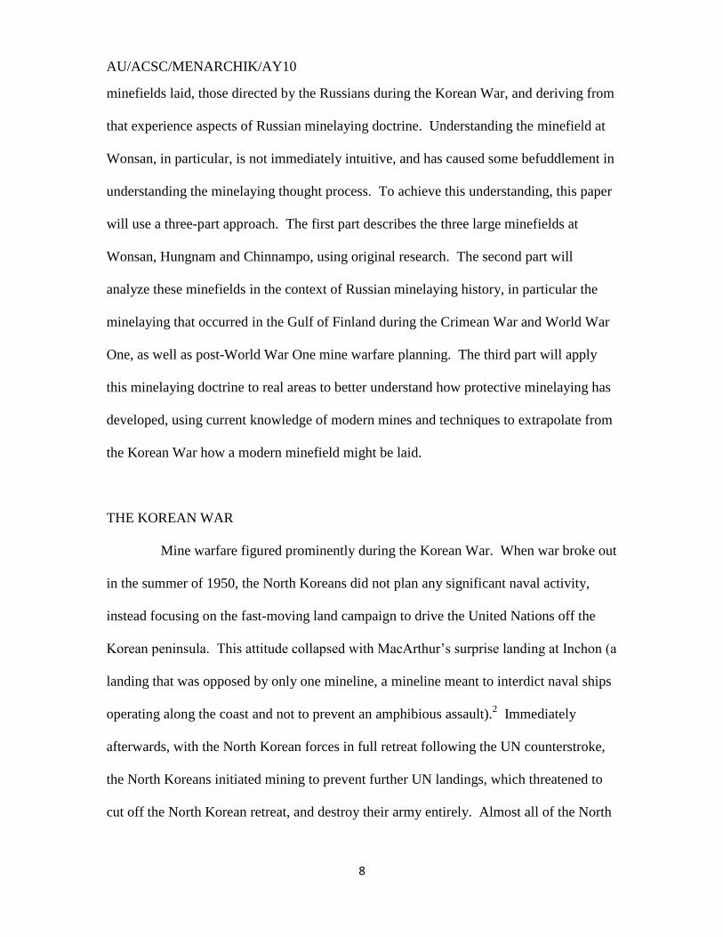
Korean ports were subsequently mined, with at least a single mineline covering the larger
ports. Particular emphasis was placed, however, on the port facilities at Wonsan,
Hungnam and Chinnampo (see Fig.1), where complex minefields were laid. The next
UN amphibious landing occurred at Wonsan as US troops were shifted to the east coast
to maintain pressure on the North Koreans. The minefield there caused the UN
difficulties, sinking four ships
(including three minesweepers)
and delaying the Marine landing
by two weeks. As the UN
advanced to the north, other ports
were swept. Hungnam and
Chinnampo were given particular
attention as these ports were large and by possessing them, the UN would shorten their
lines of communications.
The Korean War featured another abrupt turn-of-events, when the Chinese
launched a surprise counter-attack on 25-26 November 1950. The Chinese drove the UN
forces back down the Korean peninsula, apparently negating the minesweeping efforts of
the UN naval forces. Minesweeping did continue, however, as minesweepers kept
Wonsan, Hungnam and Chinnampo open for as long as UN forces occupied them. It was
particularly critical that Wonsan and Hungnam were kept open to facilitate the evacuation
of troops trapped by the initial Chinese counteroffensive. When UN forces were finally
able to stabilize the battlefront along the 38th
parallel, where it remained throughout the
war, minesweeping continued at the major ports and acted as feints to keep the Chinese
AU/ACSC/MENARCHIK/AY10
10
and North Koreans thinking about another amphibious assault on their flanks. Mining by
the Communists continued throughout the war; however, no new large, complex
minefields were laid. Mines were instead laid in small numbers as patrolling UN naval
vessels and aircraft maintained UN naval superiority and prevented any large-scale
minelaying effort. In fact, most mines found toward the end of the war were floating
mines, which had probably been released from shore or near shore. A novel addition to
this practice used late in the war was the use of water-soluble hooks that held the mine
canister together as it was set afloat, only to dissolve later and allow the mine to deploy
out at sea. While this sounds interesting, the lack of navigational control probably
limited the effectiveness of these mines.
THE RUSSIAN ROLE
The North Korean mine warfare campaign is a well-documented example of
Russian/Soviet protective mine warfare doctrine in a third-world setting. Russian mine
warfare doctrine is one of the most advanced minelaying doctrines and likely profited
from German mine experts captured during the Second World War. The minelaying
effort during the Korean War, particularly during the Wonsan campaign, showed
extensive planning, and used simplicity, geography and military experience. Mines were
laid near easily identifiable landmarks, and used geography to help defend key naval
areas. North Korean minetypes were not inter-mixed, presumably for loading and
deployment simplicity. Mine defenses were also integrated into a greater coastal defense
scheme; a particular focus of mine defenses was to decrease an opponent‟s naval gunfire
effectiveness. Russian advisors, reported in North Korea as early as 16 July 1950, were
AU/ACSC/MENARCHIK/AY10
11
prominent in the mining effort, training North Korean minelayers and overseeing
minelaying in strategic areas. All of the mines used were of Russian manufacture. Since
many of the US‟ current enemies have Russian mines and may have received Russian
training, an understanding of Russian doctrine becomes essential to understanding the
global mine threat. Since North Korea is still a foreign policy threat, and lacks the
resources to update her weaponry, understanding this campaign is vital. Many of the
characteristics and conditions of the Korean War remain true today on the Korean
Peninsula above the 38th
parallel. North Korea is suffering economically, and may rely
on dated systems and weaponry, using dated weapons to fight a modern adversary who
has forgotten how to fight against them.
AU/ACSC/MENARCHIK/AY10
12
PART I: THE MINEFIELDS
THE MINES
The North Koreans laid only 4 different types of mines (all of Russian
manufacture), three of which were moored contact mines, which are floating mines
anchored to the ocean floor and activated by direct contact with an enemy ship, and one
type was a magnetic bottom influence mine, which lies on the ocean floor and is activated
by detecting the magnetic signature of a passing ship. The three moored contact mines
were the MKB, M-26, and the Myam. The magnetic mine was an R1A, likely another
name for the Russian KMD mines.
The moored mines were varied and numerous. The most prominent mine in the
early minelaying campaign was the MKB. This mine was a heavy, deep-water mine,
which meant it targeted larger ships with its larger explosive capability. Its size,
however, made the MKB difficult to lay, and thus, cranes or special rollers were needed
for deployment. Because of this requirement, the MKB could not be laid
inconspicuously using smaller non-naval boats, and was used less extensively after the
North Koreans lost control of their territorial waters. A less often used mine was the M-
26, a lighter, shallow-water mine. This mine saw some use early in the war, but was not
as prominent as the MKB. The MKB‟s smaller size gave the North Koreans more
deployment flexibility; however, the mine was still too heavy to be laid en masse without
special handling equipment. Most of the M-26 minelines were only 5-10 mines long.
The final contact mine was a Myam, which was a small anti-boat mine. This mine was
light enough to be laid by small craft, however, the Myam was developed too late (it was
first used in 1952), to be significant for our study.
AU/ACSC/MENARCHIK/AY10
13
The only influence mine was the R1A. This magnetic mine saw little activity
throughout the war (less than 30 were laid), but were significant nonetheless. Having an
influence mine laid amongst the moored mines complicated the minesweeping problem.
Minesweepers used different sweeping gear for magnetic and contact mines, as
minesweepers use expansive wire structures fitted with cutters to cut the cables of the
moored mines, but must special gear that simulates the magnetic field of a passing ship to
trigger the magnetic mines. Because this mine had to sink a ship while being deep in the
water, a large explosive had to be used. This extra weight, as in the case of the MKB,
made this mine difficult to lay once the North Koreans lost control of their coastal seas.
Floating mines were not employed in the initial defense. While numerous
floating mines were reported throughout the war, we have no record of any substantive
number of floating mines being encountered by the minesweepers during their approach
in 1950, and only 15 floating mines were encountered during the May-December 1951
sweeping of Wonsan. This number is particularly surprising since May through
September experienced some of the busiest time-periods for Wonsan minesweeping.
THE MINELAYERS
Due to the hurried nature of the minelaying effort and the lack of a substantive
North Korean navy, any vessel the North Koreans could get was used to lay mines.
During the initial mining effort, when the North Koreans were relatively secure in their
own waters, mines were loaded on barges and towed to the minefield by tugs. These
barges were built originally for coastal and river transportation, but were fitted with three
pairs of 1.5” rails, arranged parallel to the centerline, to hold mines. Each barge was
AU/ACSC/MENARCHIK/AY10
14
stated to have a capacity for 10-15 mines. The tugs were navigated by trusted North
Korean personnel, and the mines were deployed at timed intervals, reported as 1-1.5
minutes. The Russians were reported to be directly involved in laying the magnetic
mines; otherwise all minelaying was conducted by the North Koreans.3
Later, as the UN naval forces asserted themselves and achieved naval
superiority, the North Koreans could not conduct extensive minelaying. As a result, with
fewer naval vessels available, they conducted minelaying by more commonplace, non-
naval platforms. Reports indicate the North Koreans used sailing junks, powered junks,
barges, tugs and fishing sampans. Sampans used “heavy timbers” laid athwartship
(across the ship) that could carry four M-26 mines.4 Mining operations were typically
conducted at night by these vessels to conceal their mission. The capture of the crew of a
minelaying junk in 1952 reveals how the North Koreans laid mines at this stage of the
war. Interrogations revealed that they positioned the mines by navigating from a set
reference point, by eye, without instruments in the dark, and the mines were spaced by
assuming a boat speed of one knot. The captured boat carried two magnetic mines, and
was rowed by 4-6 enlisted men chosen for that purpose.5
CHINNAMPO
For the Chinnampo sweep, the UN forces had a lot of information;
unfortunately, that information was not preserved. Little data exists to evaluate these
mine defenses; only the Interim Evaluation Report of that time period survives. No other
records of any substantive value appear could be found. Chinnampo is the port facility
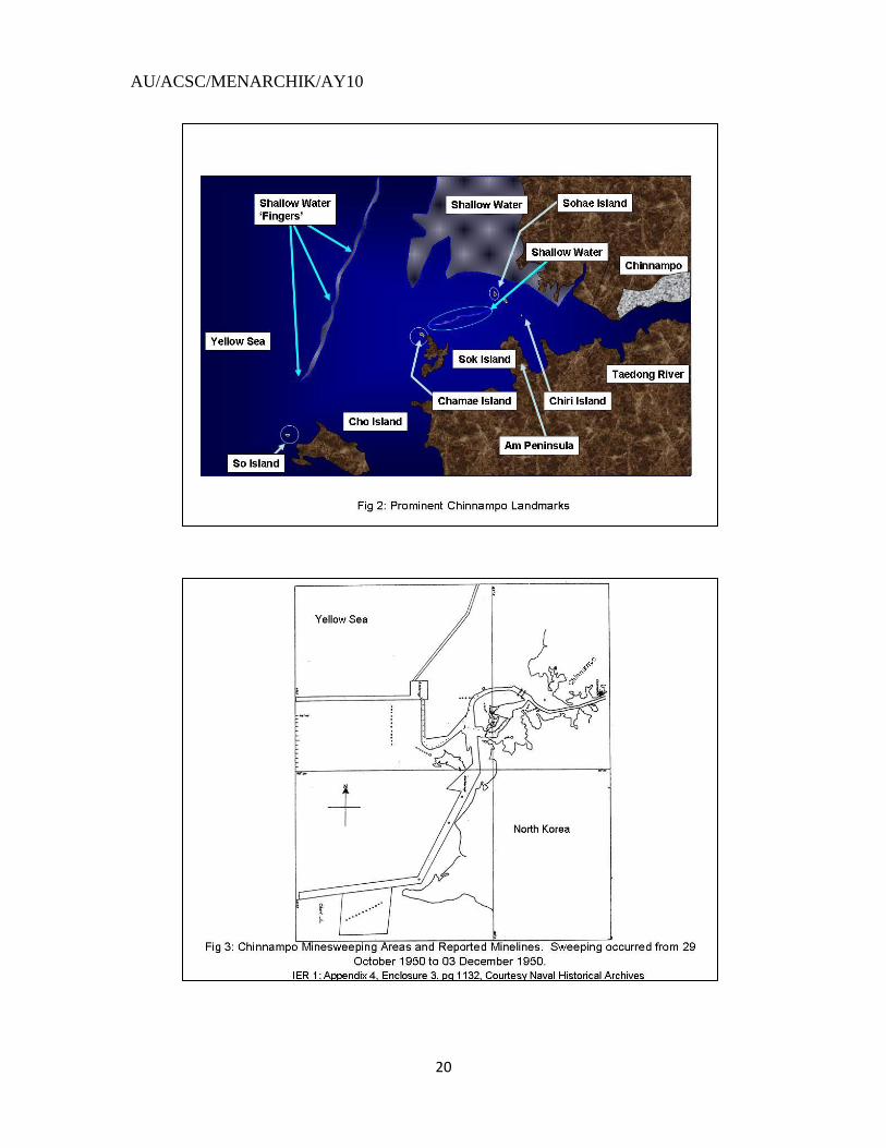
that services Pyongyang, the North Korean capital (see Fig. 2). The Taedong River heads
AU/ACSC/MENARCHIK/AY10
15
south from Pyongyang, and then turns west, where it opens into the Yellow Sea at
Chinnampo. The entry into the port is covered by two islands, Cho and Sok, and is
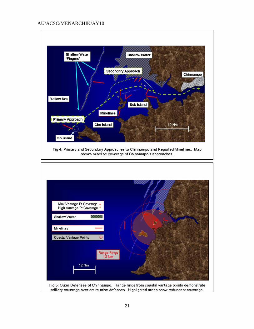
protected by very shallow waters around the channel. Sweeping at Chinnampo occurred
from 29 October 1950 to 03 December 1950. According to the First Interim Evaluation
Report, 80 moored mines and 4 magnetic mines were swept. In the appendix timeline
appears the ominous phrase "Moored and magnetic mines remained unswept.”6
Referring back to the IER, 217 moored and 25 magnetic mines were reported.7 Looking
at the Chinnampo sweeping campaign map in the IER (see Fig. 3), one gets a good look
at where these swept mines were located, and where the reported mines were believed to
be located. Five minelines were believed to have been swept; one of them was a
magnetic mineline. The US Navy had received exact intelligence on where mines were
located and was thus able to avoid any casualties during the minesweeping. The North
Koreans were very systematic in their defense of Chinnampo. They used geography to
place minelines across sea-lanes and provided redundant coverage of these channels. In
all, 12 minelines (see Figs. 3, 4) were reported, none of which was more than 12 miles
from shore. Almost all of the minelines were near a geographic landmark; these
locations, presumably, facilitated night-time navigation, or navigation without proper
instruments.8 By placing mines near strategic islands, the North Koreans made these
islands off-limits as bases for providing cover for UN ships from North Korean shore
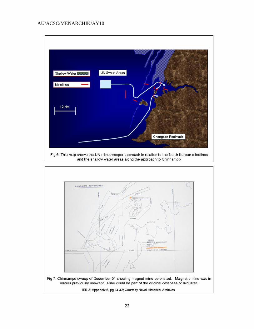
defenses. The outer defenses began with two minelines in the vicinity of Cho Island (see
Fig. 5). Both of these minefields blocked the outer access into Chinnampo. One line was
a north-south mineline, the southern point of which was approximately 10 miles from
Cho Island. This line blocked the western approaches, and was approximately 7 miles
AU/ACSC/MENARCHIK/AY10
16
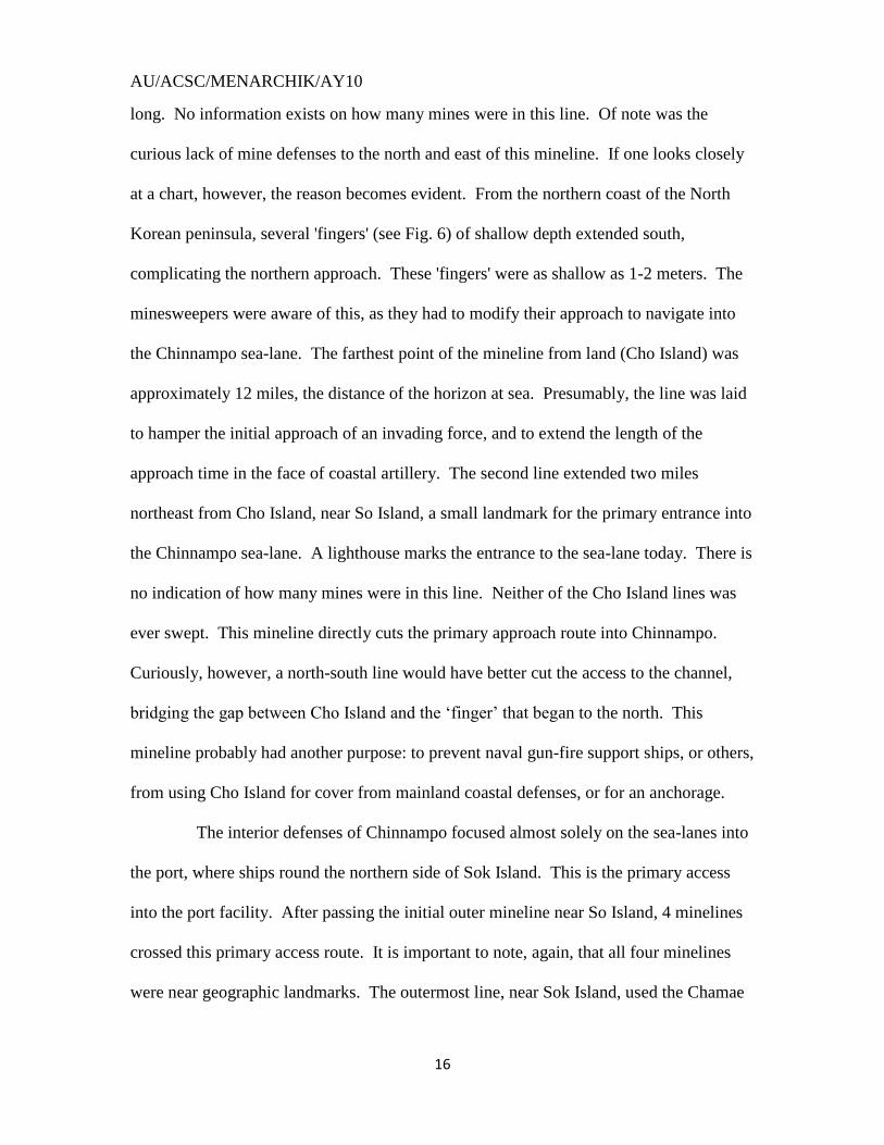
long. No information exists on how many mines were in this line. Of note was the
curious lack of mine defenses to the north and east of this mineline. If one looks closely
at a chart, however, the reason becomes evident. From the northern coast of the North
Korean peninsula, several 'fingers' (see Fig. 6) of shallow depth extended south,
complicating the northern approach. These 'fingers' were as shallow as 1-2 meters. The
minesweepers were aware of this, as they had to modify their approach to navigate into
the Chinnampo sea-lane. The farthest point of the mineline from land (Cho Island) was
approximately 12 miles, the distance of the horizon at sea. Presumably, the line was laid
to hamper the initial approach of an invading force, and to extend the length of the
approach time in the face of coastal artillery. The second line extended two miles
northeast from Cho Island, near So Island, a small landmark for the primary entrance into
the Chinnampo sea-lane. A lighthouse marks the entrance to the sea-lane today. There is
no indication of how many mines were in this line. Neither of the Cho Island lines was
ever swept. This mineline directly cuts the primary approach route into Chinnampo.
Curiously, however, a north-south line would have better cut the access to the channel,
bridging the gap between Cho Island and the „finger‟ that began to the north. This
mineline probably had another purpose: to prevent naval gun-fire support ships, or others,
from using Cho Island for cover from mainland coastal defenses, or for an anchorage.
The interior defenses of Chinnampo focused almost solely on the sea-lanes into
the port, where ships round the northern side of Sok Island. This is the primary access
into the port facility. After passing the initial outer mineline near So Island, 4 minelines
crossed this primary access route. It is important to note, again, that all four minelines
were near geographic landmarks. The outermost line, near Sok Island, used the Chamae
AU/ACSC/MENARCHIK/AY10
17
Island (a lighthouse is currently on this island). This mineline was approximately 1 mile
long and may have had a double purpose. A quick-look at a nautical chart shows how
this line blocked not only the access lane into Chinnampo, but also a modern waiting area
for incoming vessels. This mineline was most likely the magnetic line, as such a mine
was found here during the 2-3rd
IER period (see Fig. 7). This mineline was not listed as
being swept in the 1st IER, but this omission may reflect a partial sweeping of the area, as
allied minesweepers probed westward. The other four magnetic mines may also have
been part of this line. The other three minelines used landmarks to defend the channel as
well. Two minelines again used Sok Island as a starting point. The first line headed due
north from the northern tip; the second headed northeast. These minelines may also have
been placed to keep allied ships from loitering around the island to avoid coastal gunfire.
The last mineline originated from the Am peninsula near Sohae-ri. The mineline headed
north-northeast to a point near the Chiri Island.
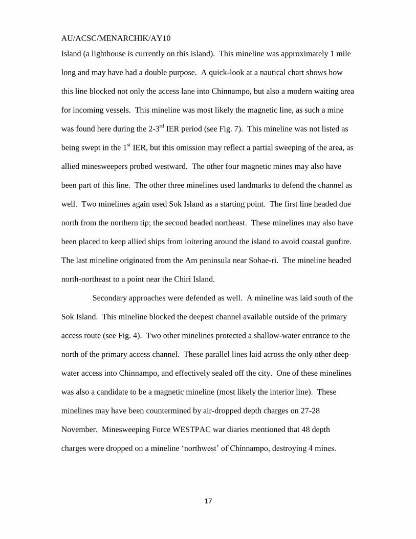
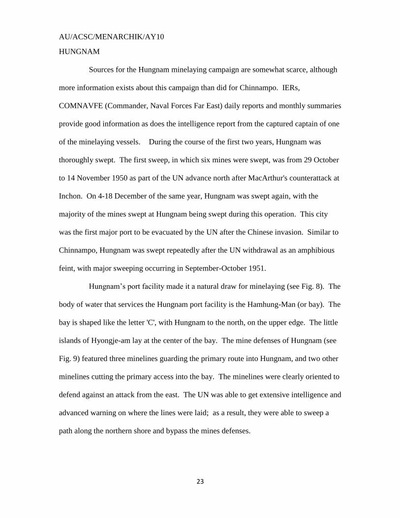
Secondary approaches were defended as well. A mineline was laid south of the
Sok Island. This mineline blocked the deepest channel available outside of the primary
access route (see Fig. 4). Two other minelines protected a shallow-water entrance to the
north of the primary access channel. These parallel lines laid across the only other deep-
water access into Chinnampo, and effectively sealed off the city. One of these minelines
was also a candidate to be a magnetic mineline (most likely the interior line). These
minelines may have been countermined by air-dropped depth charges on 27-28
November. Minesweeping Force WESTPAC war diaries mentioned that 48 depth
charges were dropped on a mineline „northwest‟ of Chinnampo, destroying 4 mines.
AU/ACSC/MENARCHIK/AY10
18
Since only one mineline was mentioned, this mineline was more probably the one below
Sok Island.9
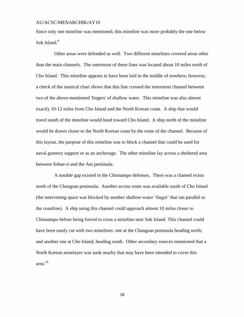
Other areas were defended as well. Two different minelines covered areas other
than the main channels. The outermost of these lines was located about 10 miles north of
Cho Island. This mineline appears to have been laid in the middle of nowhere; however,
a check of the nautical chart shows that this line crossed the innermost channel between
two of the above-mentioned 'fingers' of shallow water. This mineline was also almost
exactly 10-12 miles from Cho Island and the North Korean coast. A ship that would
travel south of the mineline would head toward Cho Island. A ship north of the mineline
would be drawn closer to the North Korean coast by the route of the channel. Because of
this layout, the purpose of this mineline was to block a channel that could be used for
naval gunnery support or as an anchorage. The other mineline lay across a sheltered area
between Sohae-ri and the Am peninsula.
A notable gap existed in the Chinnampo defenses. There was a channel exists
north of the Changsan peninsula. Another access route was available south of Cho Island
(the intervening space was blocked by another shallow-water „finger‟ that ran parallel to
the coastline). A ship using this channel could approach almost 10 miles closer to
Chinnampo before being forced to cross a mineline near Sok Island. This channel could
have been easily cut with two minelines: one at the Changsan peninsula heading north;
and another one at Cho Island, heading south. Other secondary sources mentioned that a
North Korean minelayer was sunk nearby that may have been intended to cover this
area.10
AU/ACSC/MENARCHIK/AY10
19
After the minesweepers cleared Chinnampo on 03 December 1950, interior
probing of the Taedong River stopped. Chinnampo was evacuated two days later under
pressure of the Chinese counterattack. The approaches to Chinnampo continued to be
swept, usually as part of a feint, faking an amphibious landing. Most of the
minesweeping attention shifted to the East Coast.
AU/ACSC/MENARCHIK/AY10
20
AU/ACSC/MENARCHIK/AY10
21
AU/ACSC/MENARCHIK/AY10
22
AU/ACSC/MENARCHIK/AY10
23
HUNGNAM
Sources for the Hungnam minelaying campaign are somewhat scarce, although
more information exists about this campaign than did for Chinnampo. IERs,
COMNAVFE (Commander, Naval Forces Far East) daily reports and monthly summaries
provide good information as does the intelligence report from the captured captain of one
of the minelaying vessels. During the course of the first two years, Hungnam was
thoroughly swept. The first sweep, in which six mines were swept, was from 29 October
to 14 November 1950 as part of the UN advance north after MacArthur's counterattack at
Inchon. On 4-18 December of the same year, Hungnam was swept again, with the
majority of the mines swept at Hungnam being swept during this operation. This city
was the first major port to be evacuated by the UN after the Chinese invasion. Similar to
Chinnampo, Hungnam was swept repeatedly after the UN withdrawal as an amphibious
feint, with major sweeping occurring in September-October 1951.
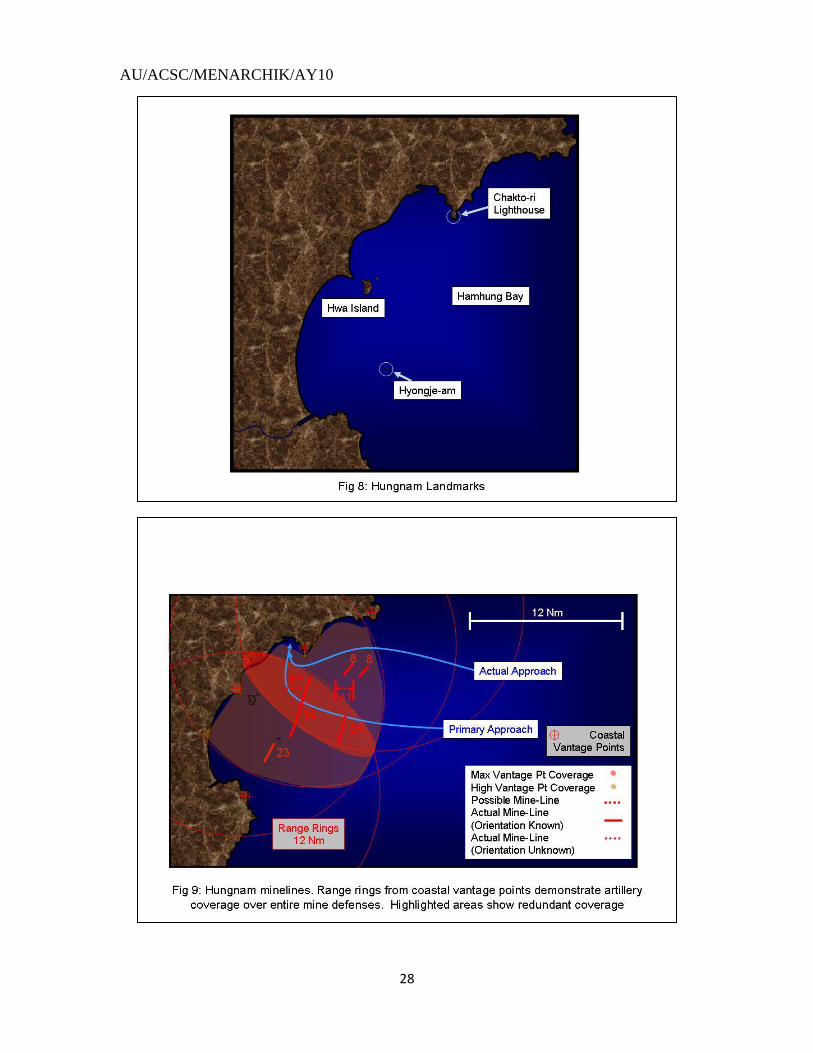
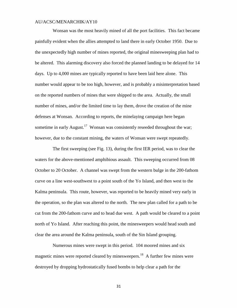
Hungnam‟s port facility made it a natural draw for minelaying (see Fig. 8). The
body of water that services the Hungnam port facility is the Hamhung-Man (or bay). The
bay is shaped like the letter 'C', with Hungnam to the north, on the upper edge. The little
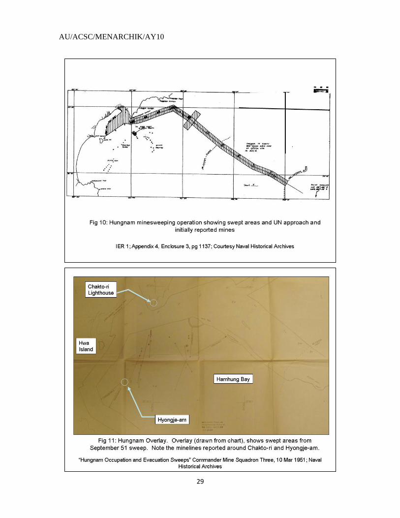
islands of Hyongje-am lay at the center of the bay. The mine defenses of Hungnam (see
Fig. 9) featured three minelines guarding the primary route into Hungnam, and two other
minelines cutting the primary access into the bay. The minelines were clearly oriented to
defend against an attack from the east. The UN was able to get extensive intelligence and
advanced warning on where the lines were laid; as a result, they were able to sweep a
path along the northern shore and bypass the mines defenses.
AU/ACSC/MENARCHIK/AY10
24
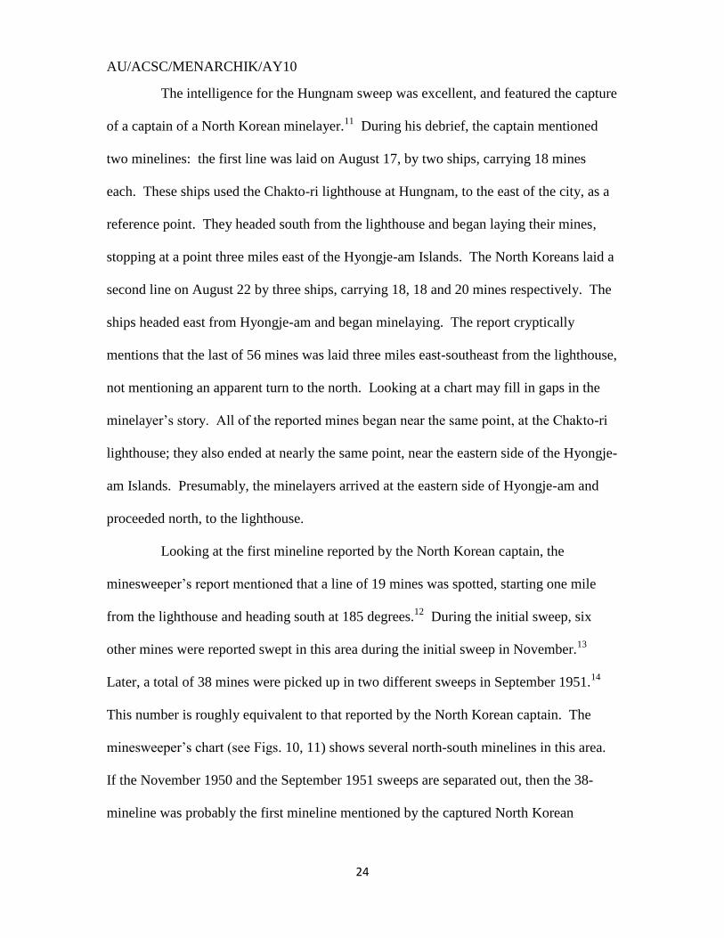
The intelligence for the Hungnam sweep was excellent, and featured the capture
of a captain of a North Korean minelayer.11
During his debrief, the captain mentioned
two minelines: the first line was laid on August 17, by two ships, carrying 18 mines
each. These ships used the Chakto-ri lighthouse at Hungnam, to the east of the city, as a
reference point. They headed south from the lighthouse and began laying their mines,
stopping at a point three miles east of the Hyongje-am Islands. The North Koreans laid a
second line on August 22 by three ships, carrying 18, 18 and 20 mines respectively. The
ships headed east from Hyongje-am and began minelaying. The report cryptically
mentions that the last of 56 mines was laid three miles east-southeast from the lighthouse,
not mentioning an apparent turn to the north. Looking at a chart may fill in gaps in the
minelayer‟s story. All of the reported mines began near the same point, at the Chakto-ri
lighthouse; they also ended at nearly the same point, near the eastern side of the Hyongje-
am Islands. Presumably, the minelayers arrived at the eastern side of Hyongje-am and
proceeded north, to the lighthouse.
Looking at the first mineline reported by the North Korean captain, the
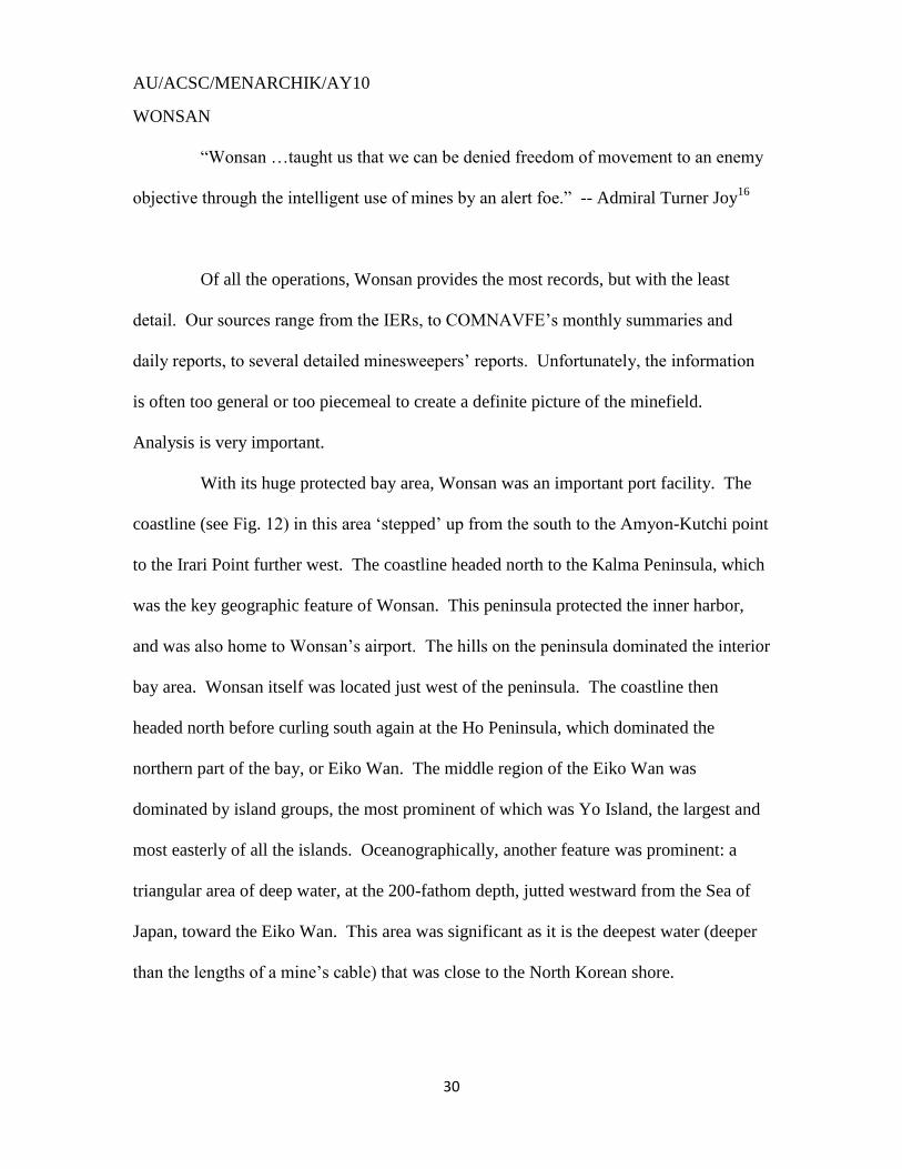
minesweeper‟s report mentioned that a line of 19 mines was spotted, starting one mile
from the lighthouse and heading south at 185 degrees.12
During the initial sweep, six
other mines were reported swept in this area during the initial sweep in November.13
Later, a total of 38 mines were picked up in two different sweeps in September 1951.14
This number is roughly equivalent to that reported by the North Korean captain. The
minesweeper‟s chart (see Figs. 10, 11) shows several north-south minelines in this area.
If the November 1950 and the September 1951 sweeps are separated out, then the 38-
mineline was probably the first mineline mentioned by the captured North Korean
AU/ACSC/MENARCHIK/AY10
25
captain. The 6-mineline may have been another mineline, or an extension of the 38-
mineline. The 38-mineline served two purposes: the first was to block the southern
approaches to the port facility; the second was to prevent the allied ships from loitering to
the east of the Hyongje-am Islands. The first purpose was accomplished by bridging the
gap between the Chakto-Ri lighthouse and the Hyongje-am Islands. The second was
accomplished by merely placing the mines near the islands.
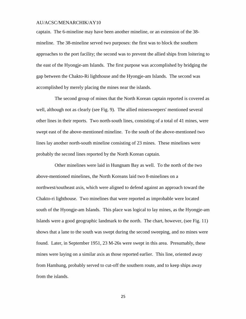
The second group of mines that the North Korean captain reported is covered as
well, although not as clearly (see Fig. 9). The allied minesweepers' mentioned several
other lines in their reports. Two north-south lines, consisting of a total of 41 mines, were
swept east of the above-mentioned mineline. To the south of the above-mentioned two
lines lay another north-south mineline consisting of 23 mines. These minelines were
probably the second lines reported by the North Korean captain.
Other minelines were laid in Hungnam Bay as well. To the north of the two
above-mentioned minelines, the North Koreans laid two 8-minelines on a
northwest/southeast axis, which were aligned to defend against an approach toward the
Chakto-ri lighthouse. Two minelines that were reported as improbable were located
south of the Hyongje-am Islands. This place was logical to lay mines, as the Hyongje-am
Islands were a good geographic landmark to the north. The chart, however, (see Fig. 11)
shows that a lane to the south was swept during the second sweeping, and no mines were
found. Later, in September 1951, 23 M-26s were swept in this area. Presumably, these
mines were laying on a similar axis as those reported earlier. This line, oriented away
from Hamhung, probably served to cut-off the southern route, and to keep ships away
from the islands.
AU/ACSC/MENARCHIK/AY10
26
One question remains about the Hamhung fields: why were gaps left along the
coastlines? The above-mentioned line off of the Hyongje-am Islands left a mile-wide gap
along the mainland coastline. The minelines that defended against the approach from the
east also left a mile-wide gap. The allies used the northern gap during their initial
approach in November 1950. Closing these gaps would have been an easy affair and
would have achieved a complete defense of the harbor area. This was accomplished at
Wonsan. Perhaps the North Koreans did not believe that the allies would reach
Hamhung, and wanted a way to get ships in and out of the bay. More likely, the gaps
were to allow minelayers access into and out of the bay, as they came to the bay from
other ports, or the North Koreans simply focused on the primary access route into
Hamhung.
Doing the math, every reported mine is accounted for. In total, 112 mines were
initially reported in the Hungnam area, as mentioned in the 1st IER.
15 The intelligence
report accounted for 92, and 20 other mines were apparently found or reported beyond
this reporting. Six mines were actually swept in this period. No mines were reported as
having been swept, despite the widened channel, in the second IER. In the third IER, 186
mines were reported as having been swept. Of these, 24 were newer MKBs or M-26s; 25
did not reference age markings; and 137 were listed as old MKBs. These numbers (137
old MKBs of the 3rd
IER plus the six swept during the 1st IER) would indicate that at least
143 mines were found at Hungnam. The total reported mines add up to 135 (the
originally reported 112 mines, plus the 23 found near Hyongje-am), providing a slight
overlap, but near complete numerical coverage.
AU/ACSC/MENARCHIK/AY10
27
To sum up, based on the above reports, the defenses of Hungnam were very
stout. The primary access route, from the east, was guarded by three minelines. The
secondary approaches, from the south, were guarded by one mineline on either side of the
Hyongje-am Islands. A mile-wide gap was left on the extreme northern and southern
ends, of the defenses. The Hyongje-am Islands were prevented from being a hiding spot
for any loitering ships. The Chakto-ri lighthouse and the Hyongje-am Islands figured
prominently as reference landmarks.
AU/ACSC/MENARCHIK/AY10
28
AU/ACSC/MENARCHIK/AY10
29
AU/ACSC/MENARCHIK/AY10
30
WONSAN
“Wonsan …taught us that we can be denied freedom of movement to an enemy
objective through the intelligent use of mines by an alert foe.” -- Admiral Turner Joy16
Of all the operations, Wonsan provides the most records, but with the least
detail. Our sources range from the IERs, to COMNAVFE‟s monthly summaries and
daily reports, to several detailed minesweepers‟ reports. Unfortunately, the information
is often too general or too piecemeal to create a definite picture of the minefield.
Analysis is very important.
With its huge protected bay area, Wonsan was an important port facility. The
coastline (see Fig. 12) in this area „stepped‟ up from the south to the Amyon-Kutchi point
to the Irari Point further west. The coastline headed north to the Kalma Peninsula, which
was the key geographic feature of Wonsan. This peninsula protected the inner harbor,
and was also home to Wonsan‟s airport. The hills on the peninsula dominated the interior
bay area. Wonsan itself was located just west of the peninsula. The coastline then
headed north before curling south again at the Ho Peninsula, which dominated the
northern part of the bay, or Eiko Wan. The middle region of the Eiko Wan was
dominated by island groups, the most prominent of which was Yo Island, the largest and
most easterly of all the islands. Oceanographically, another feature was prominent: a
triangular area of deep water, at the 200-fathom depth, jutted westward from the Sea of
Japan, toward the Eiko Wan. This area was significant as it is the deepest water (deeper
than the lengths of a mine‟s cable) that was close to the North Korean shore.
AU/ACSC/MENARCHIK/AY10
31
Wonsan was the most heavily mined of all the port facilities. This fact became
painfully evident when the allies attempted to land there in early October 1950. Due to
the unexpectedly high number of mines reported, the original minesweeping plan had to
be altered. This alarming discovery also forced the planned landing to be delayed for 14
days. Up to 4,000 mines are typically reported to have been laid here alone. This
number would appear to be too high, however, and is probably a misinterpretation based
on the reported numbers of mines that were shipped to the area. Actually, the small
number of mines, and/or the limited time to lay them, drove the creation of the mine
defenses at Wonsan. According to reports, the minelaying campaign here began
sometime in early August.17
Wonsan was consistently reseeded throughout the war;
however, due to the constant mining, the waters of Wonsan were swept repeatedly.
The first sweeping (see Fig. 13), during the first IER period, was to clear the
waters for the above-mentioned amphibious assault. This sweeping occurred from 08
October to 20 October. A channel was swept from the western bulge in the 200-fathom
curve on a line west-southwest to a point south of the Yo Island, and then west to the
Kalma peninsula. This route, however, was reported to be heavily mined very early in
the operation, so the plan was altered to the north. The new plan called for a path to be
cut from the 200-fathom curve and to head due west. A path would be cleared to a point
north of Yo Island. After reaching this point, the minesweepers would head south and
clear the area around the Kalma peninsula, south of the Sin Island grouping.
Numerous mines were swept in this period. 104 moored mines and six
magnetic mines were reported cleared by minesweepers.18
A further few mines were
destroyed by dropping hydrostatically fused bombs to help clear a path for the
AU/ACSC/MENARCHIK/AY10
32
minesweepers.19
Also mentioned, but not factored into the above numbers, were the
mines swept during the initial approach. A mission report by the squadron commander
mentions that all mines encountered were swept on the first day.20
He does not, however,
plot any of these mines on his chart, nor mentions them later in his final mine tally. In a
daily report for that same day, the minesweepers mentioned that 22 mines were swept.21
COMINERON 3 war diaries mention that 18 mines were cut on October 10.22
The IER
map shows the corner of an east-west and a north-south mineline may have been swept.
The second IER period began after Wonsan was abandoned in December.
Minesweeping continued not only as an amphibious feint, but also to keep open the
possibility of real future operations. The same channel was kept cleared, and widened,
from the 200-fathom curve to a point north of Yo Island (see Fig. 14). The path then
turned south to the limit of the 20-fathom curve, east and south of Sin Island.
Minesweeping also occurred in the area southwest of Yo Island, where a mineline had
been found in the initial sweep. Twenty-nine mines were reported swept in this period:
fifteen mines were specifically mentioned as new M-26s that were swept at the end of
March.23
Of the remainder, six were M-26s, likely not original mines; five were MKBs;
three were unknown contact/ moored. Four of these mines were known to be original
mines.
The third IER period saw the most active minesweeping activity. Wonsan was
swept repeatedly throughout this period, presumably check-sweeps (sweeping previously
cleared waters to check for re-mining) and feint operations. The main approach channel
area was kept clear with an additional magnetic sweep conducted. In May 51, the
moored sweeping widened the eastern approach to Yo Island. In mid-June of that same
AU/ACSC/MENARCHIK/AY10
33
year, the minesweeping effort focused on sweeping in northwest-southeast lines, from
deeper water, heading progressively toward shore. In July, the minesweepers headed
north from the swept approach channel, sweeping in east-west lines. Also, additional
sweeping cleared an area north of Sin Island that extended west to a point north of the
Kalma peninsula.
Minesweepers reported 325 mines swept in this period, including 317 moored
mines and eight magnetic mines.24
Of these mines, 197 were found to be original
minelines; a further 16 M-26s may also have been an original mineline.25
Of the
remaining 104 mines, 10 were floaters; 86 were identified as new or newly laid; the
remaining 8 were undetermined. All newly swept magnetic mines were planted after
1950, as they were found in previously swept areas.
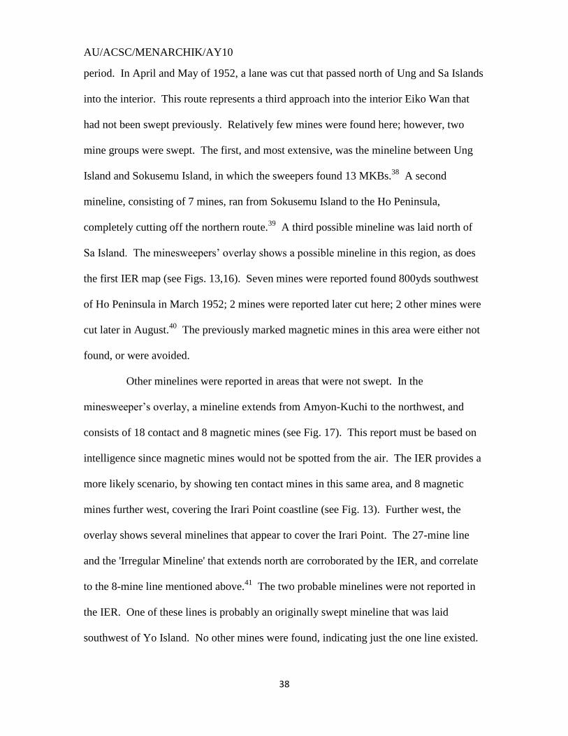
In the fourth IER period, the Wonsan minesweeping campaign shifted north,
above the continuous check-sweeping (see Fig. 15). Sweeping for this IER period began
in earnest in March 1952. The bulk of this month was spent sweeping the interior Eiko
Wan, west of the Kalma Peninsula. This area was new territory; however, the
minesweepers found no old mines. All mines found were Myams, new mines not seen
before this period. A path was swept to the north of the Taedari, Sodari and Mo Islands
and an area to the west of the islands as well.
In this time period, minesweepers found 141 mines at Wonsan.26
Taking away
the 61 Myams (all Myams were found at Wonsan)27
leaves a possible 80 mines from the
original minefield. Of the remaining 80 mines, 24 were floaters and 39 were moored.
The remainders are unknown, but the majority were probably floaters. We can account
for all 39 moored mines; of these, 16 were found to be original mines.
AU/ACSC/MENARCHIK/AY10
34
In the fifth IER period, the North Korean minelaying effort continued to taper
off. Over 104 mines were swept or destroyed in this period, with at least 78 of these
being floaters. Many of these were picked up after Typhoon Karen swept through the
area in August 1952. The authors of the mine summary believe that many of these mines
were broken loose by the typhoon. Only 20 of these were in the Wonsan area and were
old enough to be original mines. 28
Of the swept mines (from all Korean waters), 6 were
magnetic and 19 were Myam mines. In the 6th and final period, 93 total mines were
found. Of these 80 were floaters.29
During both of these last two periods, the
minesweeping consisted of check-sweeping previously cleared areas.
AU/ACSC/MENARCHIK/AY10
35
AU/ACSC/MENARCHIK/AY10
36

AU/ACSC/MENARCHIK/AY10
37
ACTUAL FINDS IN THE EIKO WAN
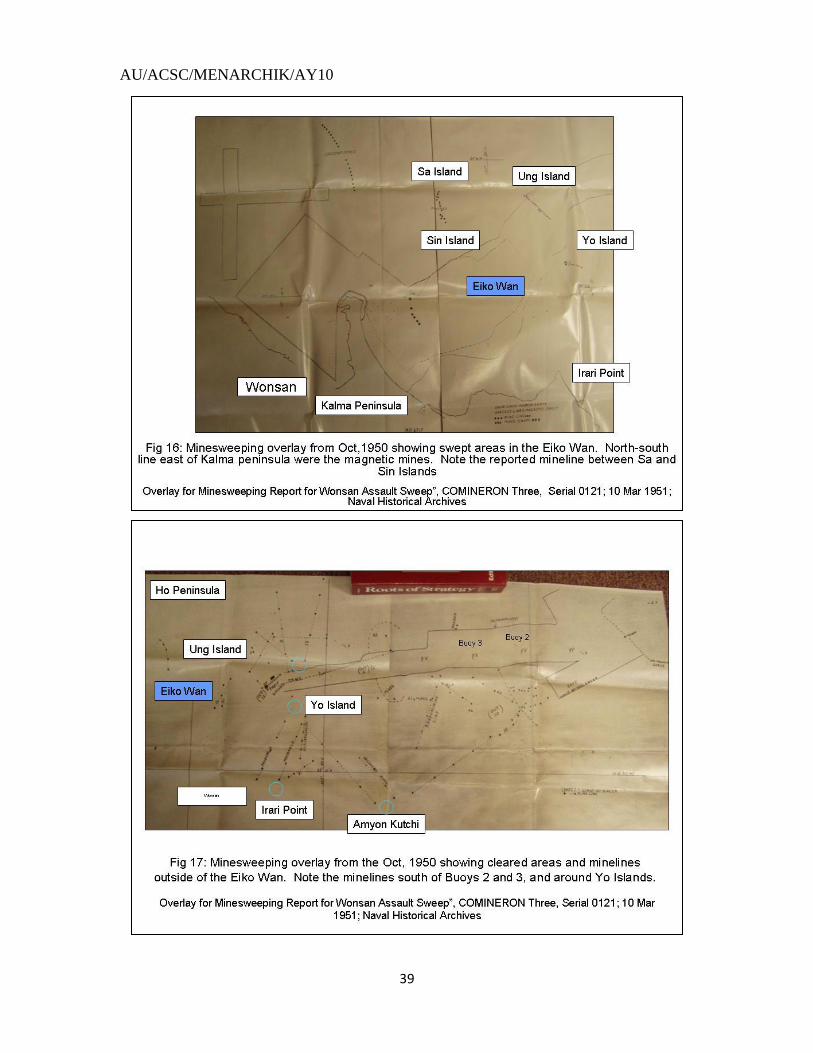
A review of the sources from the first IER period reveals that five minelines
were detected and swept in the initial effort (see Figs. 16,17).30
The first intersected the
revised route approximately five miles east of Yo Island. This mineline consisted of
approximately 42 mines.31
Further in, between Yo and Ung Islands stretched a mineline
consisting of at least 21 MKBs.32
Behind this line, a third mineline was laid. These
mines sank the Pledge and the Pirate, two of Wonsan‟s minesweeping casualties (see Fig.
16). This line stretched from Yo Island to a point northwest toward Taedari Island. This
line consisted of at least 37 MKBs.33
A fourth line covered the shallow area to the
southwest of Yo Island consisting of 4 or more mines.34
This line sank a UN
minesweeper. The final line was a line of magnetic mines that covered the eastern
approaches to the Kalma Peninsula. This line sank a Korean minesweeper. This area
was swept and a mineline consisting of 6 mines were found (see Fig. 16).
Other minelines were found among the islands around Wonsan. One mineline
blocked interior access through the Sin-Mo Island gap. During the 3rd
IER period,
minesweeping was conducted through this gap and into the Eiko Wan (interior bay) area.
A July report previously mentioned that 23 mines were reported between the Sin and Mo
Islands.35
A UDT (Underwater Demolition Team) destroyed 5 of these mines; the
remaining 18 mines were swept later, in August.36
This mineline was noted in the
original overlays of 1950. This fact, along with a larger number of mines, attests to the
fact it was an original mineline. During the 4th
IER period, the minesweepers swept an
area southeast of Yo Island, and found another string of eight MKBs in this area.37
These
mines were probably originals, as this line was marked on charts from the first IER
AU/ACSC/MENARCHIK/AY10
38
period. In April and May of 1952, a lane was cut that passed north of Ung and Sa Islands
into the interior. This route represents a third approach into the interior Eiko Wan that
had not been swept previously. Relatively few mines were found here; however, two
mine groups were swept. The first, and most extensive, was the mineline between Ung
Island and Sokusemu Island, in which the sweepers found 13 MKBs.38
A second
mineline, consisting of 7 mines, ran from Sokusemu Island to the Ho Peninsula,
completely cutting off the northern route.39
A third possible mineline was laid north of
Sa Island. The minesweepers‟ overlay shows a possible mineline in this region, as does
the first IER map (see Figs. 13,16). Seven mines were reported found 800yds southwest
of Ho Peninsula in March 1952; 2 mines were reported later cut here; 2 other mines were
cut later in August.40
The previously marked magnetic mines in this area were either not
found, or were avoided.
Other minelines were reported in areas that were not swept. In the
minesweeper‟s overlay, a mineline extends from Amyon-Kuchi to the northwest, and
consists of 18 contact and 8 magnetic mines (see Fig. 17). This report must be based on
intelligence since magnetic mines would not be spotted from the air. The IER provides a
more likely scenario, by showing ten contact mines in this same area, and 8 magnetic
mines further west, covering the Irari Point coastline (see Fig. 13). Further west, the
overlay shows several minelines that appear to cover the Irari Point. The 27-mine line
and the 'Irregular Mineline' that extends north are corroborated by the IER, and correlate
to the 8-mine line mentioned above.41
The two probable minelines were not reported in
the IER. One of these lines is probably an originally swept mineline that was laid
southwest of Yo Island. No other mines were found, indicating just the one line existed.
AU/ACSC/MENARCHIK/AY10
39
AU/ACSC/MENARCHIK/AY10
40
ACTUAL FINDS: BEYOND THE EIKO WAN
Determining where the minelines were laid outside of the Eiko-Wan is very
difficult. None of the sources give explicit locations of these minelines. The original
minesweepers‟ reports and charts (in October 1950) list many minefields, but only one
was swept. While minesweeping in this area began in earnest in May 1951, some records
from this period survive; however, none have definitive detail. Most of the existing
information comes from the 3rd
IER, with collaboration from sporadic minesweepers‟
reports.
The minesweeping of the 3rd
IER period revealed how extensively the outer
approaches had been mined (see Fig. 14). All of the mines swept were found to the east
of Yo Island. The May and June sweeps of 1951 focused on the area south of the
previously swept channel; in July, the minesweeping effort shifted to the north of the
same channel. The main effort focused on the area directly east of Yo Island. Helicopter
and intelligence reports from the initial sweep in 1950 suggested that extensive mining
occurred in this area. The minesweepers reported numerous mines; many of these are
corroborated in the IER (see Fig. 13). For example, the minelines of 20 and 42 mines are
clearly marked on both the IER and overlay (see Figs. 16, 17). The 15-mine line located
south of buoys 2 and 3 on the IER is represented by 25 mines on the minesweepers‟
overlay. The two axial minelines of 20 and 15 mines are represented by a 39-mineline
that extends almost entirely to the Amyon-Kuchi coastline.
Actual mines swept corroborate many of the depicted minelines. An important
clue in deciphering the mine reports comes from a line from the June mine summary,
which mentions that “no new minelines were found”, thus establishing these older
AU/ACSC/MENARCHIK/AY10
41
minelines as the only minelines swept.42
The first mineline swept was the 20-mineline
nearest to shore. A total of 21 mines were swept in this area. Two mines were swept
during channel-widening in March; two more were swept in April; the rest were swept in
May. The minesweepers swept 13 mines on 16 May; an additional four were swept on
the 14th
.43
The 2nd
mineline swept was the 42-mineline. This line may have been started
off by the sweeping of two mines on 22 May (although they may also be part of the
previous mineline as the only location data given was in relation to the nearest buoy).44
Sweeping continued in June with 10 mines swept on the 8th, 36 swept on the 14th, and
14 swept on the 17th.45
These numbers corroborate the reported numbers with 10 extra
mines for either this line, or for the first one. The 3rd
mineline was the 15-mine line.
Also in this area were the 39 (or 15)-mineline and the 15 (or 22)-mine line that ran
perpendicular to the coast line, along the originally planned approach lane (see Fig. 13).
These numbers would mean that as few as 45 mines account for all 3 minelines.
Unfortunately, only 32 mines were swept in this area.46
To this tally, however, we must
add 24 mines swept in October 1950.47
These mines would presumably be added to the
22 or 15-mineline mentioned as a trap field. Two mines were reported swept when a
minesweeper had to divert south of the channel to avoid other traffic.48
The 22 reported
swept on 10 October, 1950 are more perplexing. Since the originally planned channel
was reported to have 39 and 22 minelines by a patrolling helicopter, and 22 mines are
reported swept on the 10th
, one of these minelines was probably swept before this
approach was called off the next day. This reasoning would mean, of course, that
minesweepers went further west than previously reported. Since the only source for how
the minesweepers actually swept is based on the minesweepers‟ reports themselves, and
AU/ACSC/MENARCHIK/AY10
42
since the IER appears to follow these reports, then we can assume that the charts are
mistaken, or do not note the full extent of the sweeping accomplished in this area. The
charts may indicate only those waters established as swept, and not incomplete efforts.
The 1st IER indicates an extensive mineline that consists of only 8 mines
covering several miles (see Fig. 13) laid along a north-south axis; the minesweeper‟s
overlay does not show this line. No mines were found that specifically indicate such an
extensive mineline was laid. Such spacing is not practical for stopping an invasion, or
inhibiting naval gun-fire support. Minesweeping at the end of June 51, however, may
have swept up some of these mines, as this time period saw the beginning of the
northwest-southeast axis minesweeping, which swept from the sea to shore, as mentioned
above in the 3rd
IER discussion. Some of these mines may have been swept up also
during the 10 October 50 sweeping, as the IER indicates (see Fig 13). Most likely,
however, this mineline did not exist.
The vast area south of the swept channel may also have had mine defenses. The
southern limit of this area extended approximately 10mi north of Amyon Kutchi, and
extended out roughly 12 miles from this point. Along the southern limit, 16 mines were
reported: two lines along a northeast-southwest axis, consisting of five and nine M-26s,
straddling a horizontal line 10mi north of Amyon Kutchi, and two M-26s further east. 49
50 Identifying these mines is difficult. The small numbers of the mines, as well as the fact
that these mines were mostly M-26s may indicate that these were laid after the initial
minesweeping in October 1950. They may, however, coincide with the long northeast-
southwest line stretching from Amyon-Kutchi to the 39-mineline in the minesweeper‟s
overlay (see Fig.17). On the other hand, in the minesweeper‟s after-action report, it
AU/ACSC/MENARCHIK/AY10
43
mentions that “those (mines) in the southeast (Eiko) Wan were undoubtedly buoys or
jellyfish”.51
Since the closest the UN minesweepers ever approached Amyon-Kutchi was
about two miles away, and since these mines were reported on a northeast-southwest
axis, they were probably an original line.
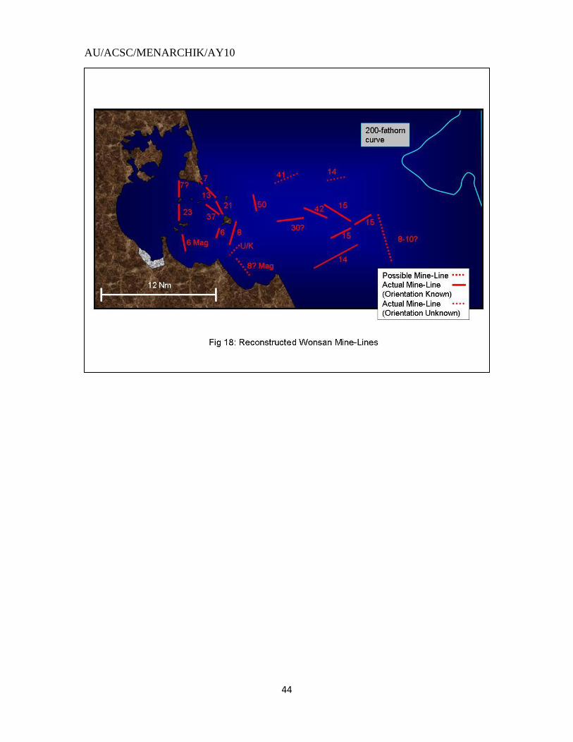
While the area north of the swept channel was not as heavily defended,
significant mining, however, did occur. In fact, UN minesweepers found two clusters of
77 mines there (see Fig. 18). A 13-mineline, presumably on an east-west axis (the
minesweepers were sweeping east to west at this point, and were not advancing that far
north), was swept north of buoy 2.52
The rest were further west, around buoy 5. The area
north of buoy 5 featured numerous mines. Seven mines were swept on 17 July, north of
buoy 5. Also in this area, minesweepers found 16 mines that were swept previously in
May, during the widening of the original channel.53
These mines were probably the
northern extension of the 42-mineline swept in October 50, east of Yo Island. Another
30 mines were swept the next day to the north of the previously swept 7-mineline.54
A
further 11 mines were swept the following day to the northeast of the 30-mineline.55
These minelines may have been part of the 30-mineline, on a northeast-southwest axis.
These mines were presumably laid to intercept naval gun-fire ships, as well as provide
some defense against an approach from the east, through the Yo-Ung Islands gap. No
further information is given, however, so we may never know for sure.
AU/ACSC/MENARCHIK/AY10
44
AU/ACSC/MENARCHIK/AY10
45
WONSAN OVERVIEW
Over 400 old or unaccounted for mines were reported swept in Wonsan waters.
This number comes from the IER-reported number of mines swept. Reporting indicates
168 mines were swept south of the channel. An additional 77 were swept north of the
channel, for a total of 245. Also to be included are the eight mines southwest of Yo
Island, giving a new total of 253 mines. Counting inside the Eiko Wan, 20 mines were
swept in the Eiko Wan (around Ung Island), increasing the total to 273 mines. If the Sin-
Mo Island mineline of 23 mines is added, the new total is 296 mines. If the 107 mines
swept in the initial approach are added, the mine count increases to 403 mines. We are
left with one old mine in May; and one mine in June; five in September; and one in
November with no information. Even with these mines, the mine total is far short of the
3,000-4,000 reported in other write-ups. This number is somewhat corroborated by the
Russians in an article that states that 500 mines were laid there.56
Additional mines could
remain in waters unswept by the UN.
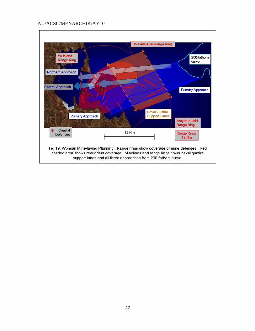
As described above, Wonsan was very heavily defended in a mine warfare
capacity. Minelines were laid out to visual range (12 miles). Mines were used to defend
against an approach from the 200-fathom-curve bulge to the opening of the Eiko Wan,
south of Yo Island. As mentioned in the minesweeper‟s report, the North Koreans laid
mines here to prevent this open area from being a staging ground for an amphibious
assault. Mines were also laid perpendicular to the coastline to prevent naval gunfire
support. As an opposing ship approached from the north-east from the 200-fathom bulge,
it found numerous mines (see Fig. 19). Its route to the open area south of Yo Island
would have been entirely blocked off by the extensive minelines running east-west and
AU/ACSC/MENARCHIK/AY10
46
northwest/southeast. These minelines, due to their perpendicularity to the coastline,
served a particular purpose: they inhibited gun-ships patrolling along the coastline.
These minelines may have been augmented by harassment lines laid further south along a
horizontal line 10mi north of Amyon Kutchi. If this ship successfully passed through
these lines and attempted to penetrate into the Eiko Wan, presumably heading south of
Yo Island, it would have found two more lines south of Yo Island. The first was a north-
south line just east of the island; the second was the mineline southwest of Yo Island that
sank a Korean minesweeper. Any ship attempting to avoid coastal defenses would not be
able to hide behind Yo Island, as the numerous minelines forced ships away from the
island.
The northern and central approaches were also well defended. If a ship chose to
approach Wonsan from a more northerly route, it would have found two minelines
blocking its approaches. Successful penetration of these two lines would have brought
the ship into the 13-mineline between Ung Island and Ho Peninsula, or the 7-mineline
between Sokusemu Island and the Ho Peninsula. If a ship chose to run from the 200-
fathom bulge to the center route between Yo and Ung Islands, as the minesweepers did,
they would have found three minelines, as mentioned above. Further travel on this route
between Sin and Sa Islands would have found a final 23-mineline between these last two
islands. The long coastline along the Kalma Peninsula, where the initial landing was
accomplished, was defended by a line of 6 magnetic mines. The Amyon-Kutchi coastline
may have been similarly defended.
AU/ACSC/MENARCHIK/AY10
47
AU/ACSC/MENARCHIK/AY10
48
Part II: North Korean Minelaying Analysis:
“War demands sacrifices in untold numbers and in various ways. Combat,
notwithstanding all these terrors, usually includes something that borders on the sublime,
the magnificient; yet mine warfare, be it on sea or land, embraces an element of
ghastliness and fiendishness” – Lieutenant General von Tschischwitz57
A look at the minefields above, particularly Wonsan, reveals a complexity to
the minefields. To understand why mines were laid where they were, one must
appreciate the history of Russian/Soviet protective minelaying and the development of
minelaying doctrine. The Russians normally fought in a state of naval weakness, so they
appreciated naval mine warfare. As a result of their planning and experience, minelaying
developed from simple geographic/oceanographic isolation, to gunfire support
interdiction, to an integrated coastal defense. The hallmark of this integration was the
mine-artillery position, which became institutionalized in Russian/Soviet naval doctrine.
Initially, the mine-artillery relationship was dominated by the mine, with artillery used in
support. The doctrine progressed by using mines to support artillery. The Russians
accomplished this progression by moving mine defenses away from the coastline. This
movement forced gun-fire support ships further away from shore, reducing their
effectiveness by making them fire at longer ranges, or far enough that their guns could
not reach the shore, but placing them in danger of long-range coastal artillery. Minefields
were always within range of the artillery, as this allowed for protected reseeding should
AU/ACSC/MENARCHIK/AY10
49
minefields be swept by the enemy, thus completing the symbiotic connection between
artillery and mines.
Russian protective minelaying began very early, during the Crimean War in
1854, when the Russians mined the Gulf of Finland in order to prevent Allied
(British/French) operations in the vicinity of the Russian capital, St. Petersburg. The
Russians laid both electric command-activated mines and contact mines at the entrances
to the major port facilities along the Gulf of Finland (Russia owned Finland at that time),
to include the major ports of Sveaborg (994 mines) and Kronstadt (1,865 mines).58
The
minelines laid here simply stretched across the harbor entrances.59
The major ports did
have artillery present. Two British ships were damaged by the mines, causing the British
to maneuver ineffectually through the rest of the campaign, thus removing the threat to
Saint Petersburg.
The next major instance of Russian protective mining occurred during the
Russo-Japanese War. The war began in 1904 with Japanese surprise attacks throughout
Asia. The early action became focused around the area of Port Arthur, a natural harbor
on the Kuan Tung Peninsula (see Fig.20) in modern northeastern China. The Russians
owned the port, but the Japanese wanted it to control the Yellow Sea and the Bohai Gulf,
as well as to extend their power inside China. Port Arthur was defended by
approximately 20 artillery batteries along the coast and along Tiger Island that ranged up
to seven miles out to sea.
The fighting at Port Arthur began on the 9th
of February when the Japanese fleet
conducted a night attack, firing torpedoes at the Russian fleet arrayed defensively at the
mouth of Port Arthur, under the protection of the coastal batteries. The main action
AU/ACSC/MENARCHIK/AY10
50
occurred the next day when the main fleet conducted a pass approximately two miles in
front of the Russian fleet. After suffering some hits from the Russian artillery, the
Japanese fleet returned to their anchorage on the Korean coast. Following this attack, the
Russians began their first protective mining effort. As the Russians feared an amphibious
assault, they began mining many of the bays around the Kuan Tang peninsula; the three
bays around Dalien (to the north of Port Arthur) and Eight Ships Bay received the initial
attention (see Fig.20). These minelines were laid parallel to the coast, or using
oceanography or geography to isolate the bays from Japanese assault. Eight hundred
mines were laid.60
The Japanese had determined, however, to conduct an overland assault on Port
Arthur, and focused their naval efforts on blocking the harbor entrance by sinking a ship
there, and to thus trap the still potent Russian Navy inside. Three „blocking‟ expeditions
were conducted. The first failed due to difficulties navigating at night and under the glare
of Russian searchlights, as well as due to the heavy gunfire from shore. The Japanese
later, on the 25th
of February, conducted a long-range bombardment of Port Arthur, from
approximately 4-5 nautical miles away. Due to the effect of Russian coastal batteries,
the Japanese conducted their second bombardment from the south, six miles away,
covered by the hills of a peninsula, Lao-Tieh (see Fig.20), to the south. As a result, the
next Russian mining effort focused on the southern portion of the peninsula, where 25
mines were laid to obstruct future Japanese bombardments, on the 25th
of March.61
A
gun was placed on the Lao-Tieh in support. A second attempt was made to block the
harbor, and it too was unsuccessful. The first mining successes of the war were scored,
although it was the Japanese who were successful. They laid mines outside the harbor
AU/ACSC/MENARCHIK/AY10
51
where the Russians had habitually traveled and, as a result, one battleship was sunk and
another was severely damaged. As a result of the continued attempts to block the harbor,
the Russians laid 135 mines outside the harbor entrance in mid-April. The mines were
laid in two groups, with three lines extending east from the shoreline southwest of Port
Arthur, and another three minelines extending southwest from the shoreline east of Port
Arthur and then bending due west.62
These minefields had the additional benefit of being
electrically controlled by the shore. They were laid to no affect, as the third blocking
effort by the Japanese was conducted unsuccessfully. The mines laid, while perhaps
adding stress for the Japanese, did not make a significant impact on their attack.63
The
Russians minelayers were not without success, however, as they later noticed the
Japanese traveled a particular route to the south, which they mined with 50 mines. The
results were spectacular; three Japanese battleships were struck. This disaster killed the
Japanese naval offensive options, and increased the danger to the Japanese fleet with the
approach of the Russian Baltic Fleet, making its journey to Asia. The Russians were not
able to follow-up this success, and their fleet remained inside Port Arthur.
The defenses there were strengthened, as additional electric-detonated mines
were laid to supplement the existing fields.64
Additionally, 45 mines were laid at the
approaches to Taho Bay, just east of Port Arthur.65
Minelaying continued through the
summer by both sides, as the Japanese stopped attempting to block the entrances of Port
Arthur with blockships. Other than a Russian sally in July, the siege settled into a
blockade, with neither side making any further moves. On 10 August, the Russians made
an attempt to break out their navy, so that they could reunite later with the rest of the
Russian fleet to challenge the Japanese. The Russians lost the subsequent Battle of the
AU/ACSC/MENARCHIK/AY10
52
Yellow Sea and retreated back to Port Arthur, were they remained until they were
destroyed in the port by Japanese land artillery, as the Japanese closed before they finally
took the city in January in 1905.
While most of the mining conducted in this conflict by the Russians was either
to defend against amphibious assaults that did not happen or were part of a harbor
defense against the Japanese blocking efforts, the significant mining development was the
use of mines to interdict ships transiting and conducting coastal bombardments. Many
mines were laid; the most effective were the minelines off the Lao-Tieh Peninsula and the
single mineline laid that struck the three Japanese ships in May.66
This type of
minelaying is the first instance of mines being laid that were not used to block a direct
amphibious assault, but to interdict naval activity away from the coastline. A second
aspect of the Port Arthur minelaying is the relationship between coastal artillery and
mines. The concept of the mine-artillery position had not been fully formed, although it
may have received impetus by the use of mines at Lao-Tieh Peninsula to cover a gap in
coastal artillery defenses, specifically, to deny the Japanese a naval bombardment
vantage point hidden from view of the Russian guns. Mines were yet to be laid, however,
to take full advantage of coastal artillery.
The First World War was another opportunity for the Russians to develop their
minelaying doctrine. As tensions in Europe rose, Russian naval defense focus shifted
back to the Gulf of Finland. Russia, in the face of German naval strength, and fearing
Swedish collusion, planned for a defense to stall an attack for 14 days, to allow the
mobilization of a defense around the capital at St. Petersburg.67
The initial plan was to
set a line of mines both north and south of the Gogland Islands (see Fig. 21). The main
AU/ACSC/MENARCHIK/AY10
53
naval base would be Kronstadt, with an advance base at Sveaborg (Helsinki,
Helsingfors).68
The Russian fleet, still reeling from the severe losses suffered against the
Japanese, kept its fleet in a purely defensive posture, not risking further losses.
This policy did not sit well with the Russian admiral in charge of the Baltic
fleet. Admiral Essen, placed in command in 1908, sought a more aggressive stance,
believing that despite their naval superiority, the Germans would be focused on the
British, and that the Baltic would be a secondary theater for them.69
Essen sought a more
offensive posture, to include offensive mining of Swedish and German ports, and a naval
demonstration to deter the Swedes.70
The Russian naval leadership did not accept
Essen‟s plan, but agreed to establish a more forward line of defense at the Nargen-
Porkkala-Udd line, designated as the “Central Position”, which lay to the west, allowing
Essen a first line of defense further out in the Gulf.71
Moon Sound, to the south, would
also be mined. Despite this concession, the Russians‟ Baltic stance remained defensive.
In the face of an attack, the Russian fleet would retreat behind the Central Position, which
was covered by heavy artillery on the Finnish coastline.72
The main fleet would be based
at Revel (modern Tallinn), which was not completely equipped, so Helsingfors (modern
Helsinki) would serve until Revel was complete.73
At the outset of the war, the Russians immediately began to establish the
Central Position, laying 2,124 mines in 4.5 hours74
, with additional mines along the
Finnish coast.75
Mines were laid approximately 200-400 feet apart, in complimentary
lines so that a second line will fill the gaps of the first.76
Mines were laid 4-6 feet deep in
shallow water, and 15-20 feet deep in deeper water.77
By 1917, the number of mines in
this line had been increased to 11,000 mines.78
Despite being aided by Swedish
AU/ACSC/MENARCHIK/AY10
54
neutrality, the Russians did not assume the offense; the Germans did. They shelled Libau
(in modern Latvia), which, unbeknownst to them, had been evacuated, as planned by the
Russians. The Germans, contrary to Russian fears, had committed fewer forces to the
Baltic. The Russians, detecting the German weakness, began to push westward,
stationing some destroyers at Lapvik; lighter forces were moved to the Aland Islands, and
a forward base was planned at the Moon Island.79
The Russians, on 27 August, even
conducted a naval raid against the German-Swedish line of communications, although
with no effect. Later, offensive mining against the Germans was conducted against their
ports of Memel, Pillau, Bornholm, Danzig and the island of Rugen.
As 1915 opened and progressed, the Russians became more comfortable with
the notion that the Germans were not going to force the Gulf of Finland. As a result, that
began to develop a “Forward Position”, laying mines between Hango and Dago Island.
By 1917, the Forward Position would have 8,000 mines.80
They also began to mine the
Irben Strait, to the south, with 2,179 mines.81
In support of this effort, they also began
fortifying the Moon and Aland Islands. The real threat to the region began to materialize
as the German ground forces moved into the Courland region (modern Latvia). As they
advanced, the Gulf of Riga grew in importance for the Germans, as it was as a flank for
their Army. As a result, the German navy decided to sweep the Russian mines in the
Irben Strait and to mine the Moon Sound. The Russians reacted by skirmishing with the
Germans, and reseeding the minefields. The Germans were able to sweep the Irben
Strait, but were unable to mine Moon Sound. After losing 2 destroyers and a
minesweeper to mines and submarines, the Germans withdrew.82
After the Germans left,
the Russians reseeded fully the mines that had been swept.
AU/ACSC/MENARCHIK/AY10
55
In 1916, the Russians continued to develop their defenses. They renewed their
minefields in the Central and Forward positions, as well as the Irben Strait and Moon
Sound. To augment the minefields, the Russians built batteries at Zerel on the Sworbe
Peninsula, which dominated the Irben minefields, and at Cape Tachkona, on the northern
tip of Dago Island, dominating the southern flank of the advanced position. The only
significant action of this year featured a German raid against Russian shipping in the
western Gulf of Finland, behind the Forward Position. Underestimating the Russian
defenses, the Germans advanced into the Gulf, immediately losing two destroyers to
mines. After concluding the raid, which achieved very little, the Germans lost an
additional five on the return, also to mines, leaving only four destroyers to survive the
mission.
In 1917, the Russian Revolution occurred. As a result of this, the Baltic Fleet
ceased to be a factor, distracted by the political situation. The Germans, seeking to take
advantage of the situation, launched their largest Baltic naval operation, the seizure of
Osel and the Moon Islands. The Germans launched over 300 ships in support of this
operation, but were lacking in minesweepers. The German operation began with an
attack on the northwestern coast of Osel (see Fig.22). The German assault force
penetrated past a weak minefield and artillery defense to Tagga Bay. German battleships
neutralized the nearby artillery batteries at Hundsvort and Ninnast. The Germans were
running behind schedule, however, and braved the minefields protecting Tagga Bay.
Despite suffering damage to two battleships and a transport sunk due to minestrikes, the
Germans successfully landed at Tagga Bay on 12 October. A second landing occurred at
Pamerort, further north on the island, after the Germans neutralized the battery at Toffri
AU/ACSC/MENARCHIK/AY10
56
village, in the southern coast of Dago Island.83
A second group of Germans began the
penetration of the Irben Strait by engaging the batteries at Sworbe, the southern tip of
Osel. The minefields and the long-range of the Sworbe guns kept the Germans from
coming close and neutralizing the battery there. The first group, after completing the
landing at Tagga Bay and Pamerort, planned to force the shallow waters of Soela Sound,
between Osel and Dago Island, and support the army‟s passage from Osel to Moon
Island. This naval movement also would block Russian naval access into Moon Sound
and trap the Russian naval forces reacting to the Germans penetrating the Irben Strait.
The German attempt to force the Soela Sound was initially unsuccessful as shallow water
and a minefield prevented the larger German ships from supporting the minesweepers,
which received fire from Russian ships nearby.84
The Germans were ultimately able to
sweep the area, and tow a battleship near enough to provide support, allowing the
Germans to control the Sound. The Russians retreated and established a new defensive
line by laying a minefield in the inlet of Kassar Bay, north of Cape Pawasterort, which
resulted in the sinking of two German destroyers.
The German land advance on Osel allowed the naval action to shift toward the
Irben Strait. The long-range battery and the minefield made the German advance
difficult. The odd shape of the minefield took advantage of the shoals near Zerel and
forced the Germans to travel through 10 miles of mined water to enter the Gulf of Riga.
The northeastern leg of the minefield was designed to keep the Germans from further
penetration of the Gulf of Riga. The effort to sweep this area progressed slowly as the
battery at Zerel prevented the Germans from sweeping the Strait.85
The German troops
advancing from Tagga Bay silenced the battery, allowing the sweeping to succeed. After
AU/ACSC/MENARCHIK/AY10
57
gaining entrance into the Gulf of Riga, the Germans were again held up at the southern
entrance of the Moon Sound; the Russians had positioned their battleships in the Sound.
These ships, as well as the batteries at Woi and Werder, held up not only the
minesweepers sweeping the many mines there, but also the battleships and destroyers
supporting them. The minesweepers were sent to a portion of the minefield where
Russians had been seen transiting and began to sweep there. After a while, German
battleships were brought forward and chased off their Russian counterparts. Once the
ships had left, the Germans silenced the batteries at Woi and Werder. As they retreated,
the Russians sank three of their own ships to block the Sound and laid more mines to
slow the German advance.86
With the Germans controlling the island by land, and the
minesweeping effort finally succeeding to clear the Moon and Soele Sounds, the
Russians retreated. Their minefields, however, continued to exact a toll, with a battleship
damaged and a destroyer sunk and another destroyer damaged.87
These continuing losses
made the Germans wary of pursuing the Russians, preventing them from accomplishing
their goal of trapping the Russian Navy.88
With the conclusion of this fight, the Baltic
campaign was over. The Germans, having sampled Russian naval defenses in the Baltic,
did not want to try the stronger defenses in the Gulf of Finland, opting to let the land
forces threaten the Russian capital. The new communist government signed an armistice
with the Germans, and the war ended for the Russians.
Despite their lack of success in defending their Baltic Islands, the Russian
defenses were very well planned. As the Russians had been anticipating fighting in the
Gulf of Finland, extensive planning went into their defenses. As a result, they fully used
the 35,000 mines laid in the Gulf of Finland89
; the first incidence of Russian full force
AU/ACSC/MENARCHIK/AY10
58
coordination of naval vessels and submarines with mine-artillery positions occurred
here,90
and this coordination was another development of the doctrinal “mine-artillery
positions” that would dominate Soviet/Russian coastal defense doctrine for the next 50
years. These mine-artillery positions caused considerable difficulties for the Germans,
and only due to overland success and Russian political instability caused by the
Revolution were the defenses overcome. A weakness did exist in these defenses. A gap
in the mine defenses existed between Osel and Dago Islands. As a result, the artillery
positions there were able to be destroyed singularly. The damage caused by this lack of
mine coverage was made apparent during the landings that occurred on Osel, which were
not very well opposed. This lack of minelaying was likely caused by German minelaying
in the area, which the Germans had to sweep themselves to launch their assault. The
Russian artillery positions at Ninast and Hundsort were destroyed piecemeal by German
battleships that did not have to worry about minefields. The Germans were then able to
maneuver up to Tagga Bay and Pamererort virtually unopposed. The mine defenses there
were weak and easily penetrated.
Despite this weakness, the mine defenses demonstrated how effective mines
could be as a cheap, effective way of countering a large, modern naval force. During the
Battle of Jutland in 1917, the major force-on-force battle of the First World War, the
British destroyed one German battleship, one battle cruiser, four light cruisers and five
torpedo boats. In comparison, during the entire 1917 Baltic operation two German
battleships were damaged for the duration of the war, and a third was taken out of the war
for a month; two small battle cruisers, three destroyers, ten minesweepers and one
transport were sunk. While no battleships were sunk, the results of the mine campaign
AU/ACSC/MENARCHIK/AY10
59
were very comparable to what the British fleet accomplished at Jutland, with much fewer
assets than the British used.
The new Soviet government remained concerned with the Gulf of Finland, and
planning continued for its defense that led into the Second World War. As the Soviets
struggled to gain control and the Germans withdrew from the Baltic, the British
intervened to support the independence movements of the Baltic states, which the Soviets
were attempting to retake. Fearing intervention, the Soviets began minelaying in the
vicinity of Stirsudden and Shepelev on 10 August.91
The minelayers laid 438 mines at a
depth of 15 feet, 150 feet apart in 4 lines (see Fig. 23).92
The British arrived in the Gulf,
entering Revel on 12 December. The British later advanced toward Kronstadt, but were
deterred by the Russian defenses. Driving off two Soviet sorties, the British conducted
several raids into Kronstadt. Because of the mines, the British had to use torpedo boats
that were of shallow draft to carry them over the mines. Despite inflicting losses on the
Soviets, the British were unable to penetrate the mine-artillery defenses, and ultimately
departed the Gulf, allowing the Soviets to defeat the counter-revolutionaries.
Despite the change in government, the new Soviet government maintained an
emphasis on mine warfare. This emphasis mostly was due to necessity, as the arrival of
the British fleet in 1919 in the Baltic, combined with the shortage of naval assets, made
mine warfare an attractive defensive option. The vacillating role of the Navy in the
politics of the revolution, however, made the new Soviet government wary of the Navy.
Although home to the Russian Revolution, Kronstadt fell out of favor after a counter-
revolt in 1921.93
In the general atmosphere of upheaval, several mutinies occurred as
well; most notable in the mine warfare community was the mutiny on the Pripyat, the
AU/ACSC/MENARCHIK/AY10
60
minelayer responsible for mining the Soela Sound in 1917. The crew had to be replaced,
but the delay allowed the Germans to penetrate the Sound, endangering the rest of the
fleet.94
As a result, political officers were placed on Soviet ships to ensure party loyalty.
This loyalty was institutionalized by the Great Terror, when all suspected sailors, guilty
or otherwise, were dismissed and/or executed, and replaced by newer sailors who were
raised in party loyalty. This purge, while ensuring party loyalty, also calcified initiative
at the lower echelons, ensuring the disaster that would occur in 1941.
As a result of the Russian Revolution and the independence of the Baltic States,
the Soviets‟ options for the defense of the Gulf of Finland were severely limited. Due to
the loss of territory in Finland and the Baltics, as well as a shortage of mines, the Soviets
initially believed they would be limited to a defensive area just west of Kronstadt, along
the Stirsudden-Shepelev perimeter, which could be covered by the Kronstadt batteries.
The lack of mines and minelayers limited the Soviets initially to lay 2,500 mines within 2
weeks – a capacity that compares unfavorably to the 2,100 mines laid in the Baltic within
5 hours in 1917.95
In order to meet their defensive needs, the Russians considered two
plans. The first consisted of a single defense zone about 7-9 miles from the fort at
Krasnoya Gorka (see Fig.24), to be defended mostly by surface ships; the second
consisted of two mine zones, protected by coastal artillery. The latter option was chosen.
It consisted of 1,300-1,400 mines in a forward defense zone located 9-11 miles from the
Krasnoya Gorka, whose guns had a range 13 miles.96
Seven miles behind the first
mineline the fall-back defense zone would be created, with only 240 mines, so the Soviet
warships could maneuver to counter the enemy or support ground forces. The rear zone
would be covered by the Soviets‟ only battleship and the batteries of Fort
AU/ACSC/MENARCHIK/AY10
61
Krasnoarmeysky and Fort Rif, on the Kronstadt Island. As the principal landing sites for
an attack on Petrograd were not covered by Kronstadt‟s batteries, additional minefields
would be laid there, supported by torpedo boats and aircraft.
A naval exercise in 1923 revealed that this defense was too shallow, and that the
Soviets would have to extend their defense further west. The updated version of the plan
moved the defense back to the Gogland and Seiskari Islands (where the Russians had
planned for it before World War One), and since they lacked the land area to place
coastal artillery, they moved their battleships forward, behind this line. After further
exercises and planning, the Soviets increased the offensive capability of their battleships,
where they engaged a hypothetical enemy in a protracted fight, before retreating behind
the minefield.97
The offensive role of these ships was quashed by fear of hostile land
defenses (principally, the Finnish battery at Bjorko, just outside Stirsudden-Shepelev
line), and the Soviet Navy remained in a defensive posture, only moving forward when
ground forces had secured the land flanks.98
By 1928, the Soviet mine inventory had
increased enough to allow for 3,444 mines at the Stirsudden-Shepelev line, augmented by
610 sweeping obstacles, devices meant to foul minesweeping gear.
As planning continued in 1935, Soviet theory remained defensive. The Navy, still
anticipating a British attack, believed that they would attack in two waves.99
The first
wave would consist of cruisers and minesweepers, which would clear a path to the
northern shore. The second wave would consist of battleships that would engage the
coastal artillery and the Soviet Navy until a path was cleared and a landing was secured.
To counter this perceived threat, the Soviets sought to engage in a skirmish with the
hostile fleet, then fall back behind their forward defense position.100
They would then
AU/ACSC/MENARCHIK/AY10
62
engage the first wave with torpedo boats, submarines and coastal artillery.101
Once the
enemy‟s plans had been determined, the Soviets would launch their counterattack, using
battleships, long-range coastal artillery and cruisers to attack the second wave. Aircraft
and additional torpedo boats would be a mobile reserve force.102
This defense would
include 550 mines and 50 sweeping obstacles in the forward defense zone, and 2,381
mines and 902 sweeping obstacles in the rear defense zone.103
A change in leadership in 1938 brought about another review of the Baltic
defenses though the Soviet posture remained essentially unchanged. Their mine
inventory had increased, and, as a result, the mines defenses increased in strength. The
Soviets now had 4,754 mines and 1,926 sweeping obstacles, a third of which was to be
deployed at the Shepelev-Stirsudden line within 72 hours.104
The forward position at
Gogland remained. In the event of an attack, aircraft, submarines and destroyers would
reconnoiter around Tallinn, Helsinki and the mouth of the Gulf. If the enemy were
present before mine defenses had been established, they would be engaged. Troops
would then be landed on the Seiskari and Lavensari Islands and 6” guns would be
established there to stiffen the forward defense zone. As the enemy fleet entered the
Gulf, the Soviets would engage it at the forward defense zone, with submarines and
torpedo boats; the battleships would be held in the rear. Soviet naval options increased
significantly, however, in the late 1930s. With the Soviets seizing the Baltic states in an
agreement with Germany that included dividing Poland, as well as the capture of several
Finnish islands during the Finnish War and, more significantly, the Hango position that
covered the entrance to the Gulf of Finland, the Soviet Navy could plan again to defend
the entire Gulf of Finland.
AU/ACSC/MENARCHIK/AY10
63
This new plan was soon to be executed. In June of 1941, the Germans launched
their invasion of the Soviet Union, taking the Soviets by complete surprise. Despite the
surprise, the Russian Navy took initial actions to defend the Gulf. On 22-24 June, 3,000
mines and 500 sweeping obstacles were laid.105
The mines were not laid at the
Stirsudden-Shepelev line, but were at the mouth of the Gulf, taking advantage of the
Soviet territorial acquisitions at Hango and Dago Island.106
Offensive mining also was
conducted by air-drops against Finnish ports.107
Mine-artillery positions were begun to
defend the Irben Strait and the Gulf of Finland. The Gulf of Finland position was to have
three mine barriers. The first two barriers were laid against large naval ships. Each of
these barriers consisted of two rows of mines and a row of anti-sweep mines. The third
barrier was laid against submarines, and consisted of two rows of mines set at different
depths. To screen the entire field, it was planned to lay eight one-row minelines to the
west, and two each on the flanks. The minefields were to be supported by artillery at
Hango and Osmus Saar Island, just off the Estonian coast. Reality set in, however, as the
Soviet mine inventory would not support such an extensive operation. Instead, the plan
was modified to lay two and half rows of mines108
, supported by two rows of antisweep
mines and two rows laid against submarines.109
A Central Position was also laid,
supported by 3,059 moored contact mines and 498 anti-sweep mines. Mines were also
laid here against submarines, in two rows, at depths of 75 feet and 120 feet.110
These
lines were noted to be ineffective against submarines, as the Gulf could get as deep as
270 feet, suggesting a third row at a lower depth was necessary.111
Mines were also not
laid against shallow draft vessels or minesweepers. The proportion of anti-sweep mines
also was noted to be insufficient.112
The Irben Strait also was planned to be extensively
AU/ACSC/MENARCHIK/AY10
64
mined, with 1,647 mines and 500 anti-sweep mines in ten lines covering 20 miles. Four
minelines were to be laid against large surface ships, four against small ships, and two
against submarines. Because of the weather and German army success, the Soviet
minelaying effort here was limited to only two lines: a field of 60 mines was laid near the
Mikhailovsky Shoals (off Zerel), and 120 mines were laid in the Shoals and the rest of
the Irben Strait.113
A total of 1,178 mines and 40 anti-sweep mines were laid in the Irben
Strait and in the Gulf of Riga, including a mineline from Abruka Island to Kurassare
peninsula.114
This effort resulted in the Gulf being denied to the Germans, with three
German minesweepers sunk as a result,115
allowing the Soviet Navy to hover on the flank
of the German Army, now in Latvia. With Finland entering the war, the artillery flanks
of the Forward and Central Positions were exposed. The Soviets reacted by mining the
old Gogland line, with minelines running along the Gogland-Bol‟shoy Tyuters Island-
Kunda Bay, with its development in depth to the line at Sommers (Mayak) Island-
Lavensari- Kurgal‟skiy Peninsula.116
To support these minefields, coastal batteries were
set up at Gogland, Bol‟shoy Tyuters and Lavensari.117
As the German Army advanced,
another position was prepared near Narva, Lavensari, the Kurgal‟skiy Reef and
Shepelev.118
A total of 5,657 mines and 1,480 anti-sweep mines were laid in these two
positions.119
At least five lines were laid against minesweepers in the rear position.120
In spite of this effort, it was the Germans who had the most success in mine
warfare. In the Gulf, German and Finnish minelayers began mining throughout the Gulf
of Finland immediately once war was declared. Of note were the minefields near
Juminda, were 2,400 mines had been laid. These minefields, combined with Soviet
inaction allowed the Germans to maintain control of the Gulf. This control produced
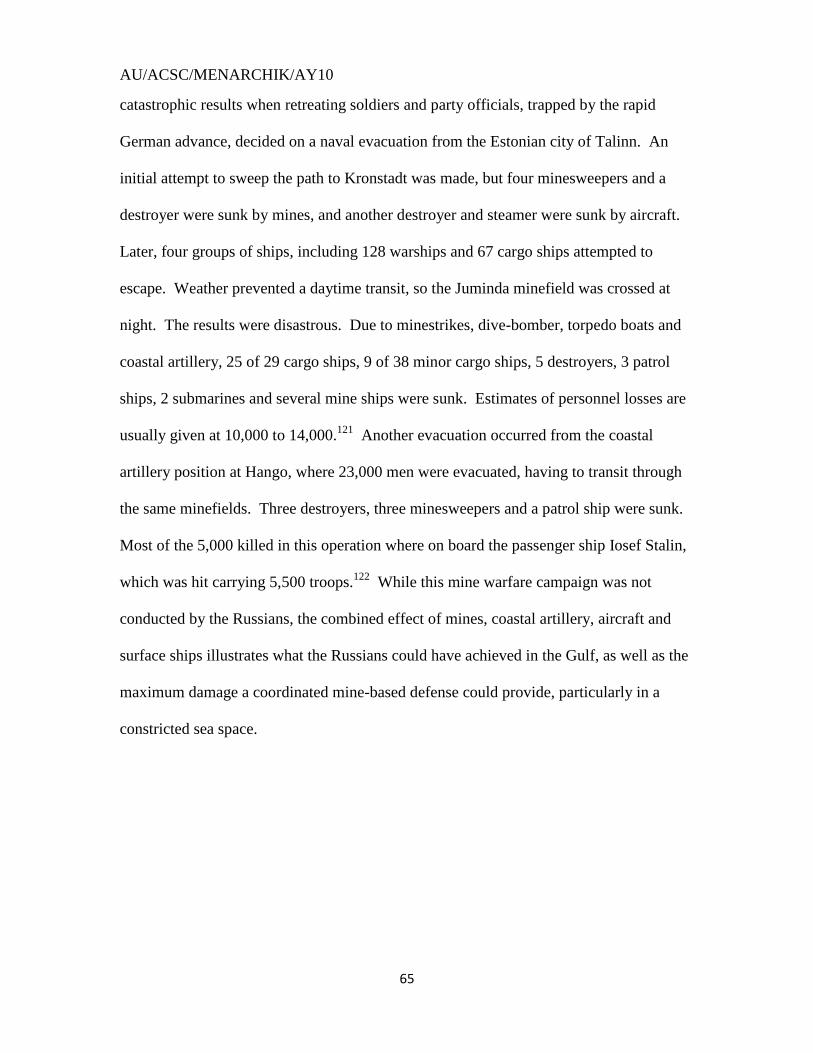
AU/ACSC/MENARCHIK/AY10
65
catastrophic results when retreating soldiers and party officials, trapped by the rapid
German advance, decided on a naval evacuation from the Estonian city of Talinn. An
initial attempt to sweep the path to Kronstadt was made, but four minesweepers and a
destroyer were sunk by mines, and another destroyer and steamer were sunk by aircraft.
Later, four groups of ships, including 128 warships and 67 cargo ships attempted to
escape. Weather prevented a daytime transit, so the Juminda minefield was crossed at
night. The results were disastrous. Due to minestrikes, dive-bomber, torpedo boats and
coastal artillery, 25 of 29 cargo ships, 9 of 38 minor cargo ships, 5 destroyers, 3 patrol
ships, 2 submarines and several mine ships were sunk. Estimates of personnel losses are
usually given at 10,000 to 14,000.121
Another evacuation occurred from the coastal
artillery position at Hango, where 23,000 men were evacuated, having to transit through
the same minefields. Three destroyers, three minesweepers and a patrol ship were sunk.
Most of the 5,000 killed in this operation where on board the passenger ship Iosef Stalin,
which was hit carrying 5,500 troops.122
While this mine warfare campaign was not
conducted by the Russians, the combined effect of mines, coastal artillery, aircraft and
surface ships illustrates what the Russians could have achieved in the Gulf, as well as the
maximum damage a coordinated mine-based defense could provide, particularly in a
constricted sea space.
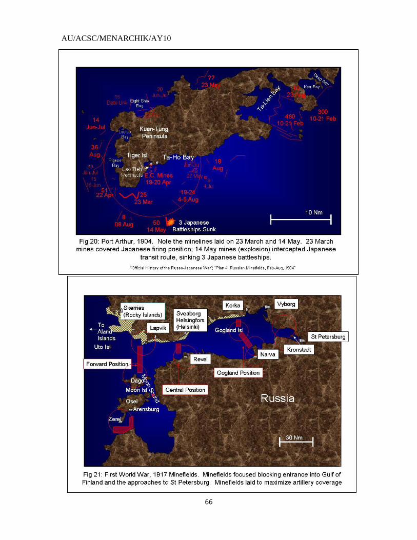
AU/ACSC/MENARCHIK/AY10
66

AU/ACSC/MENARCHIK/AY10
67
Barrett, pg.63,70
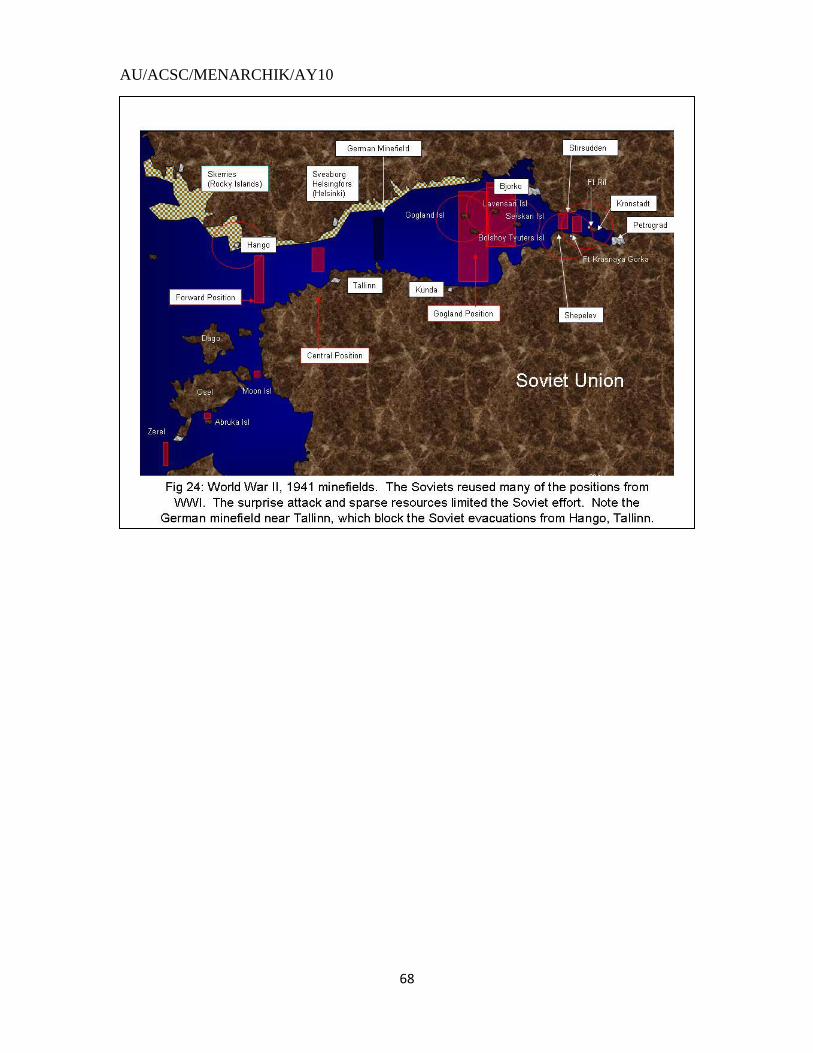
AU/ACSC/MENARCHIK/AY10
68
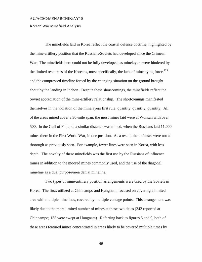
AU/ACSC/MENARCHIK/AY10
69
Korean War Minefield Analysis
The minefields laid in Korea reflect the coastal defense doctrine, highlighted by
the mine-artillery position that the Russians/Soviets had developed since the Crimean
War. The minefields here could not be fully developed, as minelayers were hindered by
the limited resources of the Koreans, most specifically, the lack of minelaying force,123
and the compressed timeline forced by the changing situation on the ground brought
about by the landing in Inchon. Despite these shortcomings, the minefields reflect the
Soviet appreciation of the mine-artillery relationship. The shortcomings manifested
themselves in the violation of the minelayers first rule: quantity, quantity, quantity. All
of the areas mined cover a 30-mile span; the most mines laid were at Wonsan with over
500. In the Gulf of Finland, a similar distance was mined, when the Russians laid 11,000
mines there in the First World War, in one position. As a result, the defenses were not as
thorough as previously seen. For example, fewer lines were seen in Korea, with less
depth. The novelty of these minefields was the first use by the Russians of influence
mines in addition to the moored mines commonly used, and the use of the diagonal
mineline as a dual purpose/area denial mineline.
Two types of mine-artillery position arrangements were used by the Soviets in
Korea. The first, utilized at Chinnampo and Hungnam, focused on covering a limited
area with multiple minelines, covered by multiple vantage points. This arrangement was
likely due to the more limited number of mines at these two cities (242 reported at
Chinnampo; 135 were swept at Hungnam). Referring back to figures 5 and 9, both of
these areas featured mines concentrated in areas likely to be covered multiple times by
AU/ACSC/MENARCHIK/AY10
70
artillery placed across the coastline. Few minelines existed outside areas these areas.
Attention was focused on the primary approach while lesser areas were ignored. This
focus may account for the gaps noted at both Hungnam and Chinnampo. Fig. 25 depicts
this arrangement in a more generic setting. The second arrangement, utilized at Wonsan,
utilized more mines to channel approaching vessels into areas covered by more vantage
points. At Wonsan, the most likely approach was to come from the east and to head
west-southwest through the open area north of Amyon Kutchi and Irari Point. The
numerous minelines that covered this area forced an opponent north. A more northern
approach was channeled south by the minelines north-northeast of Yo Island. Thus, as
happened in 1950, an opponent was funneled into the approach north of Yo Island, which
could be covered by numerous positions throughout the area. Fig. 26 depicts this second
arrangement in a more generic setting.
As mentioned above, the Korean minefields were manifestations of the mine-
artillery positions of Russian doctrine. Wonsan, in particular, illustrated this. All
minelines lay within the 12-mile radius that coastal guns could cover, allowing for
reseeding, if possible.124
These minelines also forced gunfire supports outside the 12-
mile radius of the guns like the minelines at Moon Sound and the Irben Strait in 1917.
Additionally, the minelines denied coverage in the outlying islands where ships could
find cover from the gunfire, similar to how the Russians denied the Japanese a cover
point at the Lao-Tieh peninsula in 1904. While not as extensive, similar planning was
observed at Chinnampo. Two gunfire support lines were denied with the two minelines
west of Cho Island and within the shallow water fingers to the north. The Cho Island
mineline also denied an enemy the use of that island as a vantage point. Hungnam did
AU/ACSC/MENARCHIK/AY10
71
not feature the denial of gunfire support lanes although the southernmost mineline denied
the safety of the Hyongje-am islands as a vantage point.
The Korean minefields featured two innovations: the influence magnetic mine,
and the diagonal mineline. The magnetic influence mines were first used by the Germans
during the Second World War, and account for some of the damage inflicted on the
Soviets, who were not prepared for them, during their retreat from Tallinn and Hango.
Their use at Wonsan and Chinnampo were the first time that they were used by the
Soviets. These mines were also equipped with ship counters, an internal mechanism that
counts the passes of a ship before it detonates. These mines were the last line of defense
for a hostile landing. This positioning was mostly due to the requirement to be used in
shallow water; however, it should be noted that these mines were not integrated with the
other mine-types, i.e. influence mines were laid in their own rows and moored mines
were laid in their own rows. At Wonsan, these mines were used in 36-50 feet of water.
At Chinnampo, with only one mine position given, this minetype likely was laid in a line
placed among lines with moored mines to complicate the sweeping in the vicinity of Sok
Island, similar to the mix of mines found in the Gulf of Finland during the Second World
War, when antisweeping mines were laid separately from the large surface ship lines, and
those were separate from the anti-submarine lines.
The other innovation was the diagonal mineline. This innovation was observed
primarily at Wonsan, beyond the islands that surrounded the harbor. Due to the lack of
mines or minelayers, the Soviets used an economy of mines to accomplish two missions
with one mineline. In some areas, approach lanes and naval gunfire lanes overlapped. In
these areas, diagonal minelines were used. These minelines would thus cut both lanes in
AU/ACSC/MENARCHIK/AY10
72
an economic fashion. This concept was used outside of Wonsan, and may have been
used at Hungnam, near the Hyongje-am Islands.
Other observations can be made about how the Soviets planned to lay mines.
The approaches to a harbor were usually geographically cut off. Particular attention was
paid to primary approach lanes. Islands or other natural barriers were used as references
and hinges in a mineline defense. Minelines also were placed in close proximity to each
other, particularly in tight areas, or where turning was required for navigating a channel.
At Wonsan, the minesweepers, which had cut one mineline successfully, lost 2 ships in a
second mineline while making the turn around Yo Island. This tactic may have been
attempted at Chinnampo near Sok Island, where 3 minelines were laid in close proximity.
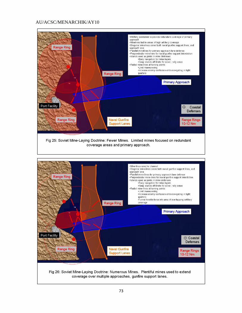
AU/ACSC/MENARCHIK/AY10
73
AU/ACSC/MENARCHIK/AY10
74
Part III: Extrapolating from the North Korean Minelaying Effort:
“No means, no expenses for the development of mine affairs can be considered
excessive. In my opinion, mines are destined to play an enormous role in future wars.”
- Admiral S. O. Makarov (Defender of Port Arthur and naval innovator)125
The first step in extrapolating from the Korean War is to look at what changed
since the minelaying campaign occurred in 1950. With the Koreans and Russians only
using moored contact mines and magnetic bottom influence mines, their inventory was
severely limited by modern standards. Additionally, other military technology has been
developed and improved, most notably coastal defense missiles. Air power has also
improved, and, as demonstrated by the Germans in World War II, must be factored into a
coordinated coastal defense. Taking these concepts and building upon the mine-artillery
coordination of the Mine-Artillery Position, one can create a realistic estimation of a
future mine defense.
Russian mine development has been significant since the First World War. As
a key element of their naval defense, the effort to complicate hostile minesweeping
efforts became an imperative. In addition to the magnetic mines used in Korea, the
Russians have developed pressure, acoustic, electric potential and seismic sensors. The
pressure sensor initially consisted of a compartment with a flexible top that has a plate
inside that separates two internal regions. As a ship passes over the sensor, the flexible
top is sucked upward by the drop in pressure caused by the Bernoulli Effect. This suction
pulls the plate up as well allowing an electrical current to pass, activating the mine.126
Acoustic sensors detect specific sound waves for activation (similar to a torpedo) and
AU/ACSC/MENARCHIK/AY10
75
seismic sensors detect the vibrations caused by a moving vessel. The electric potential
sensor detects the electricity inside of ship as it passes by. Mines have advanced in other
ways as well. Mines now have ship-counters that count off a pre-determined number of
sensor detections before detonation. This allows a minesweeper to conduct a sweep
without triggering the explosive until later. Some mines have ship counts up to 99. The
magnetic mines used at Wonsan are believed to have used sweep counts as four passes
were made to sweep these mines.127
Rising mines have also been developed that sit low
on the ocean floor, complicating the minesweeping problem with the possibility of the
sweeping gear passing over the mine. These mines rise upon activation, often rocket-
propelled, toward the target for detonation. Anti-submarine mines have also been
developed that are basically tethered torpedoes which detach and home in on the
submarine upon detection. These mines reduce the need for layered minelines to combat
the submarine problem. This multitude of minetypes complicates the minesweeping
problem by featuring different sensor-types in different minelines in a single mine
barrier, thus requiring a minesweeper to activate all of these sensors, requiring either
expensive or complex minesweeping gear, or multiple passes over minefield to sweep an
active minefield.
The greatest development in protective mine warfare doctrine, however, has
been the dissolution of the Mine-Artillery Position. This concept, as stated in the Soviet
Military Encyclopedia, has been negated by the development of cruise missiles and their
supplanting of coastal artillery as the primary defensive means.128
Two considerations
must be mentioned, however, before we discard this concept entirely: artillery is still a
key aspect of interior Russian coastal defense; and the concept of the integrated defense
AU/ACSC/MENARCHIK/AY10
76
will remain. Even if artillery has been supplanted by missiles, mines will likely be
utilized in the same manner with missiles as they were with artillery, i.e. minefields will
be pushed out further to account for the range of the missiles. An example of this new
integration occurred at Iraq in 1991 during Operation Desert Storm. The Iraqis, using
Russian mines and Chinese missiles, established minelines extending 50mi from the coast
of Kuwait (see fig. 27).129
The range of the Iraqi missiles, the CSS-C-3 “Seersucker”, is
assessed to be 50mi, providing coverage of the minefield from the Kuwaiti coastline.130
Additionally, aircraft will be a factor for both opponents. The hostile force will use
helicopters to sweep for mines; for the Russians, aircraft will be integrated into the
defense, and thus anti-aircraft missile ranges must also be accounted for. To maximize
the minesweeping difficulties, missiles and aircraft will be used to prevent/inhibit their
minesweeping, thus the need for anti-aircraft cover. The German advance at Moon
Island in 1917 will be somewhat similar to how a modern enemy will have to advance –
just the parameters will be different. Minesweepers, both surface ship and helicopter,
will still form the advance guard of a hostile assault to clear the mines away. The
effective use of mines, missiles, surface ships and aircraft are all needed to repel this
advance.
The Russians possess a very capable missile development program. For the
purposes of this paper, I utilized a 300nm range for coastal defense missiles, and a 150mi
range for anti-aircraft missiles. Most of the known coastal defense missiles possess very
short ranges (under 100mi), however, these missiles are also very old (50s/60s
technology). The Russian Oscar submarine carries the SS-N-19, which has a range of
300mi.131
I assumed this range to account for new, unaccounted for developments in
AU/ACSC/MENARCHIK/AY10
77
coastal defense anti-ship missile capability. As for anti-aircraft missiles, the Russians are
known to possess the S-400 missile, which has an advertised range of 150mi.132
The
Russians are developing an S-500 system, which will have a 300mi range, but is not
known to be in use yet.133
I have chosen to analyze two prominent Russian ports. While constrained by
geography, Saint Petersburg will always be the primary naval defensive concern for the
Russians. Analyzing Saint Petersburg will also be useful in the light of the extensive
history to see how minelaying has changed from the past, as it was the scene of so much
mining previously. The approaches to Saint Petersburg are similar somewhat to the
approaches to Tianjin, the naval port that services Beijing, a more likely opponent.
Archangel is another prominent Russian port and could conceivably see action in a
Russian conflict scenario. Archangel is also more dynamic geographically and offers a
different aspect to understanding the relationship between geography and strategy. The
White Sea approaches are similar to the Strait of Hormuz, a geography relevant to
another more likely opponent. In both scenarios, I assume that plenty of time is available
for planning, plenty of mines are available for laying, and that the laying areas are
uncontested, allowing for extensive and exhaustive planning and implementation,
conditions not necessarily to occur, as may have happened in North Korea in 1950.
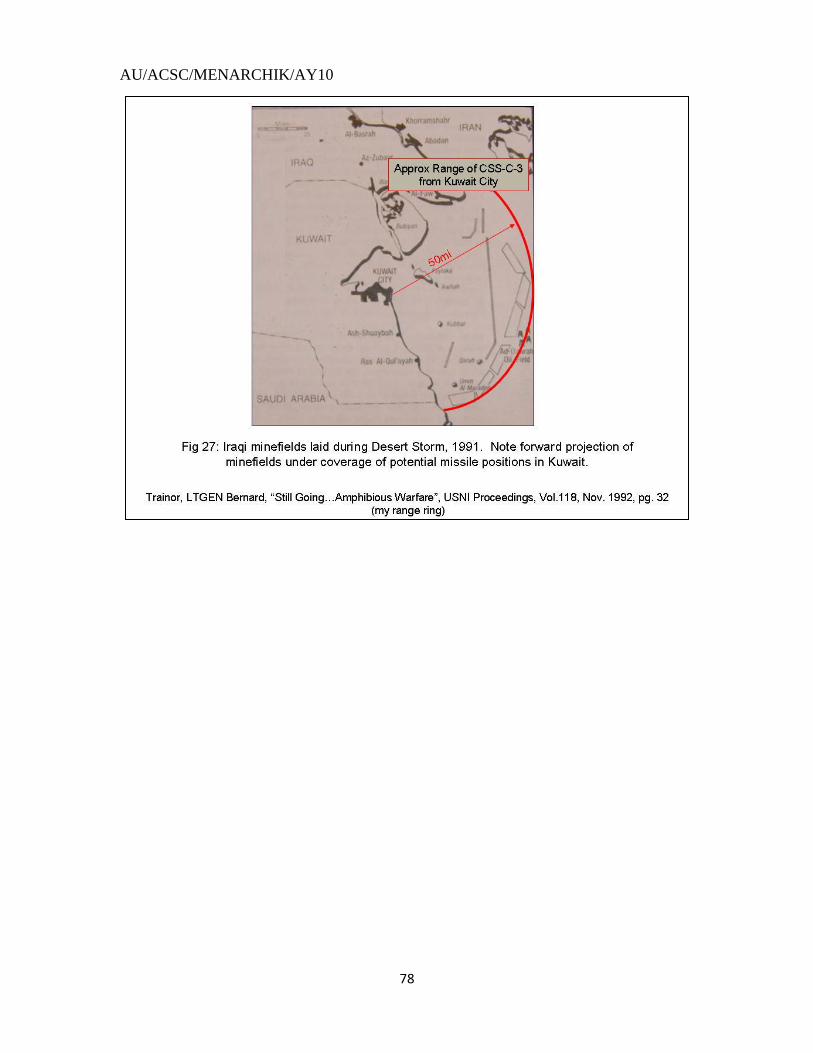
AU/ACSC/MENARCHIK/AY10
78
AU/ACSC/MENARCHIK/AY10
79
SAINT PETERSBURG
As seen in the second part of this essay, the Russians have extensively planned
for the defense of this city throughout her naval history. The current Russian situation is
similar to that which the Soviet Union faced prior to the Second World War: most of the
shoreline of the Gulf of Finland is no longer under their direct control. The very narrow
shape of the Gulf, furthermore, limits the Russians‟ options in planning for a mine
defense. These options could be expanded if the Russians seize key vantage points as
they did during the Second World War. If the Russians were to conduct these seizures,
they would likely return to Hango, Osel and Moon Islands and the Aland Islands; also not
to be forgotten is the Russian foothold in the Baltic at Kaliningrad. If the Russians opt
for the aggressive option of seizing these positions, they could mine most of the Baltic
Sea east of Denmark. As the approaches to Saint Petersburg have always been a naval
priority for the Russians, and have always seen extensive mining, the Russians would
most likely use the Wonsan arrangement for this effort. The first minelines could be
encountered around Bornholm Island, as these minefields would be supported by a
coastal defense missile system at Kaliningrad (see Fig. 28). Due to the distance from
Russian naval defenses, these mines would likely be laid by submarines and, perhaps,
defended by them as well, to complicate the approach. Moving into the Baltic, mining
would be encountered around 150mi from Kaliningrad, to support the defense of that
enclave. An advantage of placing mines this far out is that it demonstrates intent to mine
throughout the Baltic, putting pressure on an opposing force to keep any aircraft carriers
more than 500mi away from Saint Petersburg, reducing the sortie rate of carrier-based
aircraft.134
The outermost mineline would run from the Polish coast to the outer limit of
AU/ACSC/MENARCHIK/AY10
80
the coastal defense missile at Osel Island in order to force oncoming forces north inside
this supporting threat ring, similar to how ships were channeled into the northern artillery
positions at Wonsan. The bulk of Kaliningrad‟s mine defenses would be encountered
within 15 miles of the city, supported by coastal artillery.
As the hostile fleet moves north, they would encounter the mine defenses
running from the northern edge of Gotland Island to the Latvian coast. These defenses
would be supported by the coastal missiles and anti-air missiles on Osel Island, and
would constitute the outermost defense of that island. I did not include any mines west of
Gotland Island, as this would antagonize the neutral Swedes, and put pressure on the
hostile force to violate their waters. Sweden possesses a significant naval mining
capability, and has been known to mine their own waters to prevent conflict from
expanding into them, as they did during the First World War.135
Further minelines would
be found around Osel, mostly to the south. These minelines, like the minelines found at
Cho Island at Chinnampo, would serve the dual purpose of blocking entrance into the
Irben Strait and preventing Osel Island from masking coastal radar from supporting
defenses on Dago Island. Additionally, minelines would also be used to push hostile
forces to the north around Osel Island and into supporting threat rings from the Aland
Islands, Dago Island and Hango. Forces moving north would encounter the defenses to
the Aland Islands that, similar to Osel Island, would be used to defend the islands and to
force hostile forces into supporting threat rings.
The first interior mining barrier would occur between the Aland Islands and
Osel Island (see Fig.28). This mining barrier would further demonstrate Osel Island‟s
position as the hub of the Baltic defenses. This barrier is also the western extension of
AU/ACSC/MENARCHIK/AY10
81
the traditional Russian defenses between Dago Island and Hango, enabled by long-range
anti-air and coastal defense missiles. This barrier would likely feature multiple minelines
for defending against submarines, large ships and minesweepers, similar to what the
Soviets envisioned in their pre-WW2 defenses. Supporting minelines would be laid
between Osel and Dago Island in order to block the Soelesund Strait, and to prevent
Moon Island from being a rallying point for the enemy hiding from the supporting threat
rings at Hango and the Aland Islands. An additional mineline would be placed in the
traditional area in the Moon Sound between Moon Island and Estonia. A second barrier
would be encountered at the traditional area between Hango and Dago Island. This
barrier would be similarly arrayed as the Aland-Osel barrier. Osel and Dago Islands
would essentially be treated as Yo Island at Wonsan, and Cho and Sok Islands at
Chinnampo, with numerous minelines radiating out from them. As with Kaliningrad, all
islands would be defended with mine defenses within 15 miles of the coast within range
of any nearby artillery to prevent hostile forces from landing. The chokepoint at the
narrowest part of the Gulf would also be defended, covered by positions at Hango and
Dago Island, as well as Gogland Island. Another barrier, the old „Central Position‟,
would be laid at the narrowest point of the Gulf, taking advantage of the choke-point
there, as well as missile coverage from Gogland (see Fig.29). These outer minelines
would be supported by submarines, surface ships and aircraft sorties. The full array of
mines would be laid here, as this chokepoint facilitates the laying of numerous mines
rapidly. The main interior defense would occur where it traditionally has, in the area
around Gogland Island all the way to Kronstadt. This area would be thickly laid with
mines, as the fallback and final defensive positions. The numerous islands in this area
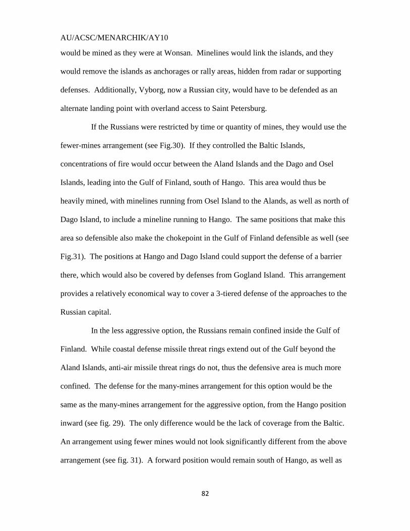
AU/ACSC/MENARCHIK/AY10
82
would be mined as they were at Wonsan. Minelines would link the islands, and they
would remove the islands as anchorages or rally areas, hidden from radar or supporting
defenses. Additionally, Vyborg, now a Russian city, would have to be defended as an
alternate landing point with overland access to Saint Petersburg.
If the Russians were restricted by time or quantity of mines, they would use the
fewer-mines arrangement (see Fig.30). If they controlled the Baltic Islands,
concentrations of fire would occur between the Aland Islands and the Dago and Osel
Islands, leading into the Gulf of Finland, south of Hango. This area would thus be
heavily mined, with minelines running from Osel Island to the Alands, as well as north of
Dago Island, to include a mineline running to Hango. The same positions that make this
area so defensible also make the chokepoint in the Gulf of Finland defensible as well (see
Fig.31). The positions at Hango and Dago Island could support the defense of a barrier
there, which would also be covered by defenses from Gogland Island. This arrangement
provides a relatively economical way to cover a 3-tiered defense of the approaches to the
Russian capital.
In the less aggressive option, the Russians remain confined inside the Gulf of
Finland. While coastal defense missile threat rings extend out of the Gulf beyond the
Aland Islands, anti-air missile threat rings do not, thus the defensive area is much more
confined. The defense for the many-mines arrangement for this option would be the
same as the many-mines arrangement for the aggressive option, from the Hango position
inward (see fig. 29). The only difference would be the lack of coverage from the Baltic.
An arrangement using fewer mines would not look significantly different from the above
arrangement (see fig. 31). A forward position would remain south of Hango, as well as

AU/ACSC/MENARCHIK/AY10
83
the Central Position. The meat of the defense, however, would exist inward of Gogland
Island, where the maze of islands could provide multiple interior firing angles against an
invading opponent. This arrangement, from the Central Position inward would similarly
constitute the interior aspect of the more aggressive option as well.
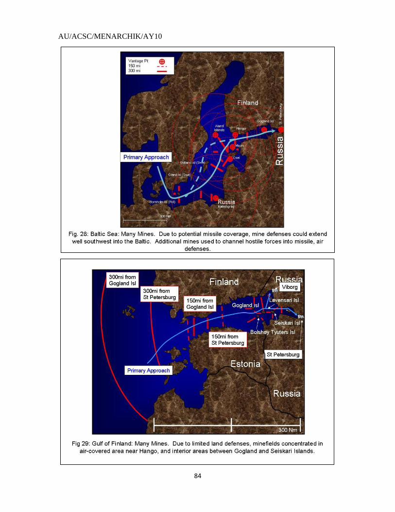
AU/ACSC/MENARCHIK/AY10
84
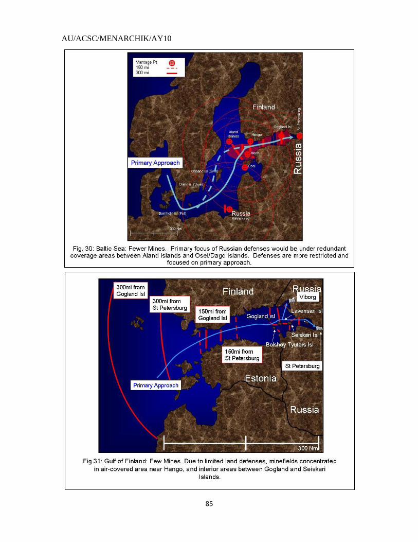
AU/ACSC/MENARCHIK/AY10
85
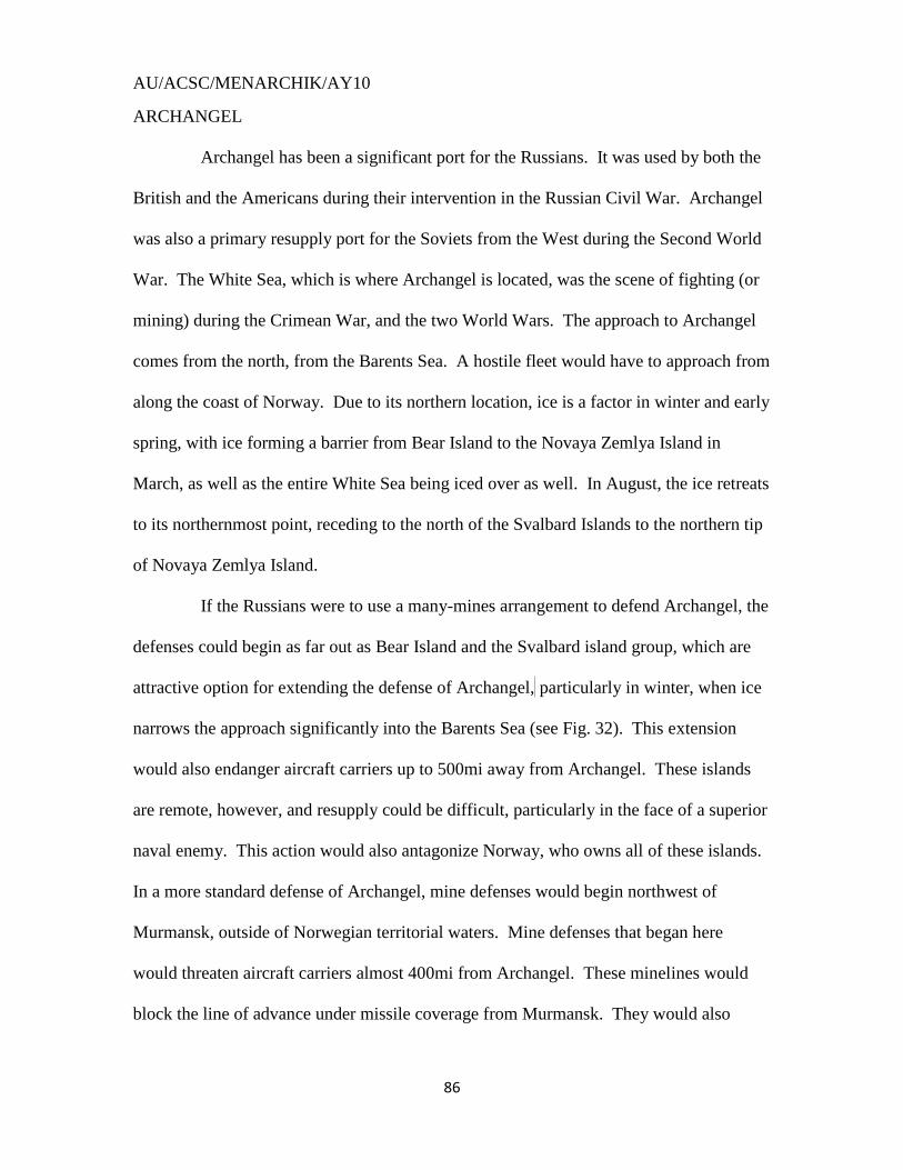
AU/ACSC/MENARCHIK/AY10
86
ARCHANGEL
Archangel has been a significant port for the Russians. It was used by both the
British and the Americans during their intervention in the Russian Civil War. Archangel
was also a primary resupply port for the Soviets from the West during the Second World
War. The White Sea, which is where Archangel is located, was the scene of fighting (or
mining) during the Crimean War, and the two World Wars. The approach to Archangel
comes from the north, from the Barents Sea. A hostile fleet would have to approach from
along the coast of Norway. Due to its northern location, ice is a factor in winter and early
spring, with ice forming a barrier from Bear Island to the Novaya Zemlya Island in
March, as well as the entire White Sea being iced over as well. In August, the ice retreats
to its northernmost point, receding to the north of the Svalbard Islands to the northern tip
of Novaya Zemlya Island.
If the Russians were to use a many-mines arrangement to defend Archangel, the
defenses could begin as far out as Bear Island and the Svalbard island group, which are
attractive option for extending the defense of Archangel, particularly in winter, when ice
narrows the approach significantly into the Barents Sea (see Fig. 32). This extension
would also endanger aircraft carriers up to 500mi away from Archangel. These islands
are remote, however, and resupply could be difficult, particularly in the face of a superior
naval enemy. This action would also antagonize Norway, who owns all of these islands.
In a more standard defense of Archangel, mine defenses would begin northwest of
Murmansk, outside of Norwegian territorial waters. Mine defenses that began here
would threaten aircraft carriers almost 400mi from Archangel. These minelines would
block the line of advance under missile coverage from Murmansk. They would also
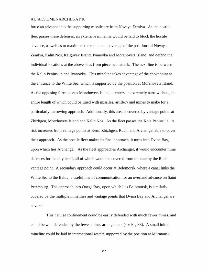
AU/ACSC/MENARCHIK/AY10
87
force an advance into the supporting missile arc from Novaya Zemlya. As the hostile
fleet passes these defenses, an extensive mineline would be laid to block the hostile
advance, as well as to maximize the redundant coverage of the positions of Novaya
Zemlya, Kalin Nos, Kalguyev Island, Ivanovka and Morzhovets Island, and defend the
individual locations at the above sites from piecemeal attack. The next line is between
the Kalin Peninsula and Ivanovka. This mineline takes advantage of the chokepoint at
the entrance to the White Sea, which is supported by the position at Morzhovets Island.
As the opposing force passes Morzhovets Island, it enters an extremely narrow chute, the
entire length of which could be lined with missiles, artillery and mines to make for a
particularly harrowing approach. Additionally, this area is covered by vantage points at
Zhizhgen, Morzhovets Island and Kalin Nos. As the fleet passes the Kola Peninsula, its
risk increases from vantage points at Kem, Zhizhgen, Ruchi and Archangel able to cover
their approach. As the hostile fleet makes its final approach, it turns into Dvina Bay,
upon which lies Archangel. As the fleet approaches Archangel, it would encounter mine
defenses for the city itself, all of which would be covered from the rear by the Ruchi
vantage point. A secondary approach could occur at Belomorsk, where a canal links the
White Sea to the Baltic, a useful line of communication for an overland advance on Saint
Petersburg. The approach into Onega Bay, upon which lies Belomorsk, is similarly
covered by the multiple minelines and vantage points that Dvina Bay and Archangel are
covered.
This natural confinement could be easily defended with much fewer mines, and
could be well defended by the fewer-mines arrangement (see Fig.33). A small initial
mineline could be laid in international waters supported by the position at Murmansk.
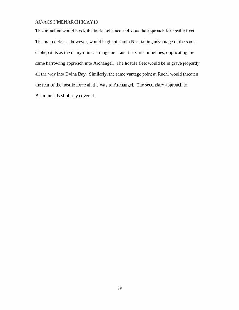
AU/ACSC/MENARCHIK/AY10
88
This mineline would block the initial advance and slow the approach for hostile fleet.
The main defense, however, would begin at Kanin Nos, taking advantage of the same
chokepoints as the many-mines arrangement and the same minelines, duplicating the
same harrowing approach into Archangel. The hostile fleet would be in grave jeopardy
all the way into Dvina Bay. Similarly, the same vantage point at Ruchi would threaten
the rear of the hostile force all the way to Archangel. The secondary approach to
Belomorsk is similarly covered.
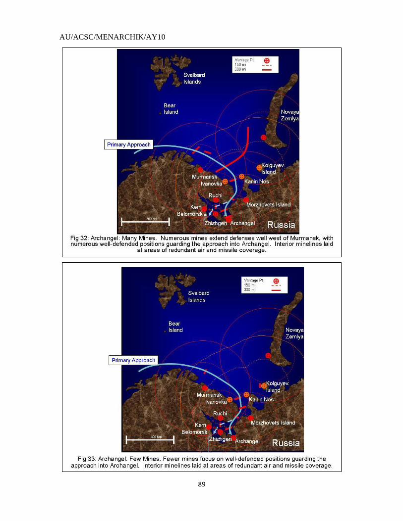
AU/ACSC/MENARCHIK/AY10
89
AU/ACSC/MENARCHIK/AY10
90
CONCLUSION
The narrow confines of the Gulf of Finland and the White Sea highlight the
complications mines create for an invading force. When one adds the capacity to lay
massive numbers of mines, mines with multiple sensors and different deployment depths,
the problem worsens. When mines are fully integrated into a sophisticated multi-axial,
complimentary coastal defense system commanded by an aggressive leader and
competent defensive force, the problem is insurmountable. This problem highlights the
capability of our adversaries to counter our carrier-based navy, and eliminate the threat
posed by our amphibious forces by laying a sophisticated mine-based defense, a defense
that represents a low-cost deterrent for our expensive, modern navy.
This capability has developed since the Russians began laying mines during the
Crimean War. As mine defenses developed from the simple geographical isolation of the
Crimean War, to coordinated complexity during the Russo-Japanese War and the two
World Wars, to a shaping, flexible defense in the Korean War, to a coordinated
naval/missile/mine defense of the modern era, their lethality increased exponentially.
Unfortunately, this lethality has been augmented by the recent lack of employment since
the Korean War. Isolated incidents of mining have occurred since then, however, these
efforts have not been significant enough to garner naval or historical attention. This
inattentiveness has caused the study of mine warfare to atrophy, to the detriment of our
navy, and to a full understanding of naval history and strategy. Hopefully, the thought of
the complexity and volume of mines laid in the Baltic during the First World War,
arranged to the shaping complexity of Wonsan, supported by modern strike aircraft and
long-range anti-ship missiles will elevate the study of minelaying.
AU/ACSC/MENARCHIK/AY10
91
1 P. 76, Melia, Tamara: “Damn the Torpedoes: A Short History of the U.s. Naval Mine Countermeasures”.
(Washington: Naval Historical Center, 1991) 2 Field, Chapter.7, pt.2; http://www.history.navy.mil/books/field/ch7b.htm#top
3 P. 1089, IER#1, “Participation of Russians”, “Participation of Koreans”.
4 P.1407, IER#2, para 2.a. “North Korean Mining Campaign”
5 P.7.49, IER#5, App.4 “North Korean Mine Laying Operations”
6 Ibid. p.1131, App 4, pg 2 “Summary of Minesweeping Operations in Korean Waters 25 June- 30 Nov
1950” 7 Ibid. p. 1132, App4, Encl 3
8 P. 7-49, IER #5, Appendix 4, “North Korean Mine Laying Operations”’ Courtesy of Naval Historical
Archives 9 P. 10,12 Minesweeping Force West Pacific War Diaries, November 1950, November 27-28. Courtesy
Navy Historical Archives 10
P. 159 “The Sea War in Korea” Malcolm Eagle, Frank Manson; US Naval Institute; Annapolis, MD 1957 11
“Mining Operations Off Hamhung-Man” Commander Mine Squadron (COMINERON) Three, 3 Nov 1950, Encl 1 “Report of LT Olenciacz to Capt Spofford” Subj: ‘Mining Operations Off Hamhung-Man”; report dated 26 Oct 1950; Courtesy of Naval Historical Archives 12
P.2 “Hungnam Occupation and Evacuation Sweeps” Commander Mine Squadron Three, 10 Mar 1951; Courtesy of Naval Historical Archives 13
P. 1137 IER #1 App4, Encl 3; Courtesy of Naval Historical Archives 14
Intelligence Periodic Reports (IPR), COMNAVFE, 25 Sep 1957; Courtesy of Naval Historical Archives 15
P.1137, IER #1, App4, Encl 3; Naval Historical Archives 16
P.79, Melia 17
P. 1088, IER #1 18
Ibid, p.1136, App 4, Encl 3 19
Ibid 20
P.2 “Minesweeping Report for Wonsan Assault Sweep” COMINERON Three, Serial 0121; 10 Mar 1951; Naval Historical Archives 21
P.2 “Commander Mine Division (COMINEDIV) 32 War Diary” October, 10 October 1950; Naval Historical Archives 22
P.4-5, COMINERON Three War Diary, October 1950; October 10, 11. Navy Historical Archives. 23
P. 1420, IER #2; Naval Historical Archives 24
P.14-23, IER#3 25
Ibid., p. 14-19-14-22 26
P. 8-39, IER#4 27
Based on a review of COMNAVFE reports “Mines Reported in Korean Waters” for the months of Jan-Jun 1952. All Myams were found near Wonsan. Reports are located at the Naval Historical Archives. 28
Statistics added up from “Mines Reported in Korean Waters”; July- December 1952;Naval Historical Archives; Typhoon Karen comment at the end of the August 1952 summary. The fifth IER period runs through January 1953, but the records for this month are lost. The 6
th IER features a mine count summary
graph for each month. Approximately 7 mines are noted for that month. Only 1-2 of these mines were moored, based on probability of the previous and following months, if that many (IER #6, p.8-57; Naval Historical Archives). 29
P.8-45, IER#6 30
“Minesweeping Report for Wonsan Assault Sweep”. Entire article discusses these 5 minelines
AU/ACSC/MENARCHIK/AY10
92
31
Ibid, pg. 4 mentions that 40 mines were found in this line. This is a miscount or misprint. Recounting the commander’s numbers show 42 mines were swept. 32
Ibid, pg.3 33
Ibid, pg.6. Another miscount. The number on this page is 29, however, the previous page shows 36 mines, plus the mine swept on page 6 brings us to 37 mines. 34
Ibid, pg 3 for the sunken ship in this line. See also IPR, Mar 51, that notes a271234 Feb report of an explosion of 2 mines that became intertwined during heavy swells. IER #2, pg. 1408 mentions another explosion in the same area. A later IPR (18 Sep) mentions a magnetic mine that was swept. This mine may have been planted after the original fields were laid. 35
IPR, 31 Jul 51, p.2; 30 Jul 51, p.2. For an accurate position change CU to CJ in the MGRS system. The CU coordinate is not near Wonsan. If my coordinate manipulation is not valid, footnote 30 citation mentions that this line lies between the Sin and Mo Islands. 36
Ibid; ‘Mine Warfare Report No.6’, COMINERON Three, Serial 0133, 31 Aug 1951 37
“Mines reported in Korean Waters”, 15Nov-31 December 1951 mention 4 MKBs swept; Feb 1952, 271257Z reports and 28150Z report add 4 MKBs. 38
“Mines Reported in Korean Waters”; March 1952, 210015Z entry; Naval Historical Archives 39
Ibid, April 1952, 91315Z report 40
Ibid, March and August 1952; 210015Z, 221337Z March; 021400Z, 031340Z August. 41
See Fig 11. p. 1136 IER #1. See pg.11 of this paper on the mine SE of Yo Island. 42
P.2-39, June 1951, COMNAVFE Monthly Summary, ref COMINERON 3 War Diary. The May 1951 Monthly Summary also mentions (on p.23 of that summary) that the search for new minelines was “uneventful”. The July 1951 summary mentions that minesweepers concentrated on “old mine lines” (P. 2-31 of that summary). Courtesy of Naval Historical Archives 43
IPR 14,16 May; COMINEDIV 31 War Diary, March 1951, 19-23 March; Serial 012-51, 03 April 1951; Naval Historical Archives 44
P.10, COMINERON 3 War Diary, May 1951, May 22; Naval Historical Archives 45
COMINEDIV 32 War Diary, June 1951, 14-17 June; Naval Historical Archives 46
Ibid. 14,17,18 June 47
See above, footnote 15 48
“Minesweeping Report for Wonsan Assault Sweep”; pg. 5 49
IPR, P.2 22 Jun 1951, helicopter sights 5 mines; on 25,26 June reports, 5 M-26s were swept; 14,11 July 1951; a 10-mine line was reported on the 11
th; a minesweeping report of 9 mines being swept was issued
on the 14th
. No proof that these reports are linked as the report on the 14th
does not mention the location of the mines swept, but the helicopter reporting the minelines may have been scouting for the sweepers; P.2 29 June 1951 2 M-26s found. 50
IPR 11,14 July 1951; 51
“Minesweeping Report for Wonsan Assault Sweep”; pg.3 52
P.9, COMINERON 3 War Diary, July 1951, 17 July 53
Ibid, P.3, May 1951, 2-3 May; P.7, May 1951, 14 May; P.10, May 1951, 22 May. 54
P. 10, COMINERON 3 War Diary, July 1951, 18 July 55
Ibid., P. 10, 19 July 56
Dotsenko, pg.18 57
Von Tschischwitz, pg.21 58
Morozov, Fish; pg. 22 59
Napier, pg. 132, 162, 225, 248. These citations discuss the Russian preparations vaguely. VADM Napier’s fleet seemed able to approach the two cities without problem. The citations also imply that the Kronstadt defenses may have stretched across Neva Bay, in which Kronstadt lies. ADM Dundas, Napier’s successor is stated to have gotten past a “barrage” to threaten the northern part of the island. 60
Halpern, pg.65 61
Ibid, pg.87 62
Ibid, pg. 102
AU/ACSC/MENARCHIK/AY10
93
63
Ibid, pg. 105 64
Ibid, pg.150 65
Ibid, pg.168 66
A total of 11 Japanese ships were sunk by mines. Aselius, pg. 32 67
Halpern, pg. 180 68
Ibid. 69
Ibid, pg.181 70
Ibid. 71
Ibid. 72
Ibid. 73
Ibid. 74
Panferov, pg.8 75
Halpern, pg.183 76
Barrett, pg.111 77
Ibid. 78
Panferov, pg.8 79
Halpern, pg. 185 80
Panferov, pg.8 81
Halpern, pg.191 82
Ibid, pg.199 83
Ibid, pg. 215 84
Ibid. pg. 216 85
Ibid. pg. 217 86
Ibid, pg. 219 87
Ibid 88
Kuvaldin, pg. 21 89
Dotsenko, pg.40 90
Ibid, pg. 42 91
Badeyev, pg.49 92
Ibid., pg.51 93
Aselius, pg.4 94
Barrett, pg.205 95
Aselius, pg.75 96
Ibid, pg. 76 97
Ibid. pg.79 98
Ibid., pg.87 99
Ibid, pg. 129 100
Ibid, pg.130 101
Ibid. 102
Ibid. 103
Ibid. 104
Ibid., pg. 178 105
Ibid, pg. 225 106
Ibid, pg.226 107
Achkasov, pg.20 108
No information on what a half-row of mines is. 109
Ibid, pg.21 110
Ibid, pg.22 111
Ibid. 112
Ibid. 113
Ibid.
AU/ACSC/MENARCHIK/AY10
94
114
Ibid, pg.23 115
Ibid., pg.23 116
Ibid, pg. 23 117
Ibid. 118
Ibid. 119
Ibid. 120
Ibid. pg.24 121
Aselius, pg. 229; 122
Ibid, pg. 230 123
Dotsenko, pg.18 124
Dotsenko, pg.18; author mentions that all minelines were within coastal artillery range. 125
Polenin, pg.67 126
Crowie, pg.162 127
Pg.108, Meacham 128
Pg.298, Kodola, SME 129
Trainor, p. 32 130
Militaryperiscope.com; “CSS-C-3 SeerSucker” 131
Militaryperiscope.com; “SS-N-19 Shipwreck anti-ship missile” 132
Janes Online; “S-400 Triumf” 133
Janes Online; “S-500” 134
The Russians believe that the Americans like to operate their carriers 150mi from shore. Pg.85, TBD 135
The Swedes mined the entrance into the Baltic from the North Sea. Pg.211, Halpern