Embed Size (px)
Citation preview

North Coast North Coast Explorer:Explorer:
A Natural ResourcesA Natural ResourcesDigital LibraryDigital Library
Renee Davis-Born and Kuuipo WalshRenee Davis-Born and Kuuipo Walsh
Institute for Natural ResourcesInstitute for Natural Resources
Oregon State UniversityOregon State University
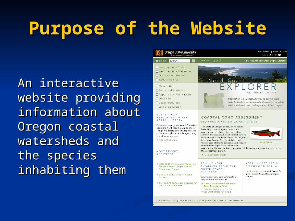
Purpose of the WebsitePurpose of the Website
An interactive An interactive website providing website providing information about information about Oregon coastal Oregon coastal watersheds and watersheds and the species the species inhabiting theminhabiting them
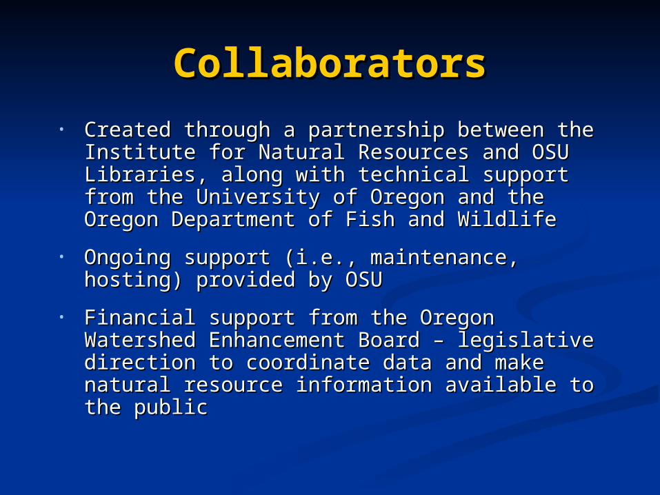
CollaboratorsCollaborators• Created through a partnership between the Created through a partnership between the
Institute for Natural Resources and OSU Institute for Natural Resources and OSU Libraries, along with technical support Libraries, along with technical support from the University of Oregon and the from the University of Oregon and the Oregon Department of Fish and WildlifeOregon Department of Fish and Wildlife
• Ongoing support (i.e., maintenance, Ongoing support (i.e., maintenance, hosting) provided by OSUhosting) provided by OSU
• Financial support from the Oregon Financial support from the Oregon Watershed Enhancement Board – Watershed Enhancement Board – legislative direction to coordinate data and legislative direction to coordinate data and make natural resource information make natural resource information available to the publicavailable to the public
Target AudienceTarget Audience
• Citizens and decision makers Citizens and decision makers actively involved in natural actively involved in natural resource use, policy and planningresource use, policy and planning
• Involved a representative user Involved a representative user group in the design and group in the design and development processdevelopment process

Key Information NeedsKey Information Needs
1. Regional trends and current status of salmonids and other native fish species
2. Regional trends and current status of land use and stream habitats
3. Human caused barriers to fish passage and locations of currently inaccessible habitat
4. Areas of greatest intrinsic potential for production of salmonids
USERS NEED DATA, TOOLS AND USERS NEED DATA, TOOLS AND EXPERTISE!EXPERTISE!

Design and UsabilityDesign and Usability
• Users can search for and Users can search for and download informationdownload information
• Information organized byInformation organized by1.1. Content typeContent type2.2. Content themeContent theme3.3. Spatial footprintSpatial footprint
Menus mirror content
organization

Classifying ContentClassifying Content
• All content tagged by topic and spatial All content tagged by topic and spatial keywordskeywords
• Uses hierarchical classification systemUses hierarchical classification system
TOPIC EXAMPLETOPIC EXAMPLEFish Fish
Coho Salmon Coho Salmon Observation/HabitatObservation/HabitatDirect TakeDirect Take
SPATIAL EXAMPLESPATIAL EXAMPLE44thth Field Watersheds Field Watersheds
AlseaAlsea NecanicumNecanicum

Different Ways to Access Different Ways to Access InformationInformation

Users can browse multi-media stories Users can browse multi-media stories to learn about various topics and to learn about various topics and understand the context of their understand the context of their decision-makingdecision-making
Stories to Help People Stories to Help People LearnLearn
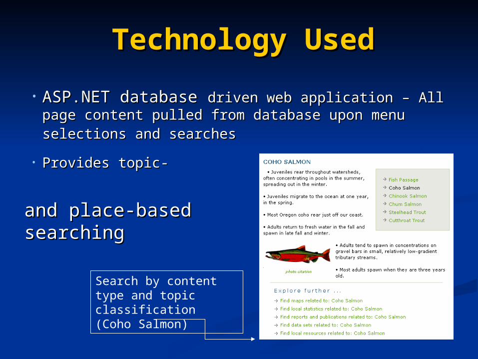
Technology UsedTechnology Used
• ASP.NET database ASP.NET database driven web application – All driven web application – All page content pulled from database upon menu page content pulled from database upon menu selections and searchesselections and searches
• Provides topic-Provides topic-
Search by content type and topic classification (Coho Salmon)
and place-basedand place-basedsearchingsearching
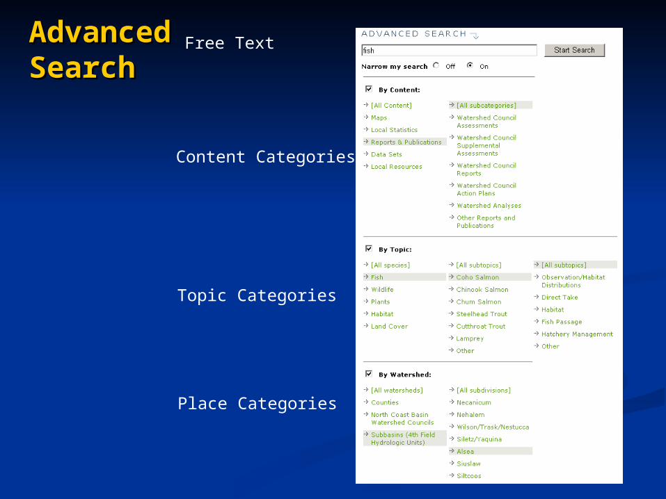
Advanced Advanced SearchSearch
Free Text
Place Categories
Topic Categories
Content Categories

Functionality and ToolsFunctionality and Tools
Special tools for:
• Mapping and web-based GIS
• Interactive report generation (statistics)
• Submission to the Explorer Digital Library via ScholarsArchive@OSU
• Discussion Forum (used very little)
• Administration
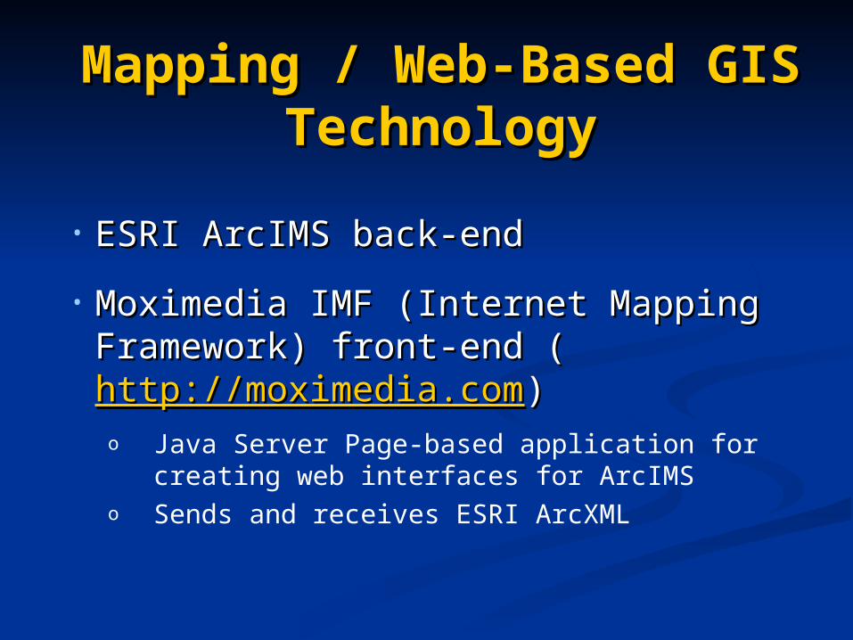
Mapping / Web-Based Mapping / Web-Based GIS TechnologyGIS Technology
• ESRI ArcIMS back-end ESRI ArcIMS back-end
• Moximedia IMF (Internet Mapping Moximedia IMF (Internet Mapping Framework) front-end (Framework) front-end (http://moximedia.comhttp://moximedia.com))o Java Server Page-based application for
creating web interfaces for ArcIMSo Sends and receives ESRI ArcXML

Mapping ToolsMapping Tools
• Pre-made mapsPre-made maps
• Mapping Tool Wizard for novice Mapping Tool Wizard for novice users (average number of maps users (average number of maps generated per day ranges from 6 to generated per day ranges from 6 to 41 for the Oregon Explorer basin-41 for the Oregon Explorer basin-level portals)level portals)
• Advanced Mapping Tool for those Advanced Mapping Tool for those familiar with GIS mapping (average familiar with GIS mapping (average number ranges from 5 to 107)number ranges from 5 to 107)

Intrinsic Potential for Coho Salmon Production
Mapping Tool WizardMapping Tool Wizard

Data in the Mapping ToolData in the Mapping Tool

Statistical Reporting Statistical Reporting ToolTool
1.1. A statistic to reportA statistic to report
2.2. Time period(s)Time period(s)
3.3. Location(s)Location(s)
For datasets where data can be ingested For datasets where data can be ingested into the North Coast Explorer database, into the North Coast Explorer database, users can use a multi-step, interactive users can use a multi-step, interactive wizard to create custom tables and wizard to create custom tables and graphs of data by selecting:graphs of data by selecting:

Riparian Restoration Projects

Administration ToolsAdministration ToolsProvide login protected web tools forProvide login protected web tools for
• Adding/removing content recordsAdding/removing content records• Classifying content (i.e., topic, place, Classifying content (i.e., topic, place,
and content type)and content type)

Data AccessibilityData Accessibility
• Based on OSU’s Natural Resources Based on OSU’s Natural Resources Digital Library, the Oregon ExplorerDigital Library, the Oregon Explorer
• Users can easily search for and Users can easily search for and explore metadata, data and explore metadata, data and informationinformation
• Used Open Archives Initiative Used Open Archives Initiative Protocol for Metadata Harvesting to Protocol for Metadata Harvesting to acquire metadata held elsewhereacquire metadata held elsewhere

Limitations to Data Limitations to Data AccessibilityAccessibility
• At present, many data are manually At present, many data are manually entered into the Explorer databases from entered into the Explorer databases from other sources.other sources.
• Evolving focus is on distributed networks.Evolving focus is on distributed networks.
• Open archives harvesting needs to be Open archives harvesting needs to be expanded to access other spatial and expanded to access other spatial and relational data.relational data.
• New Explorer projects will expand tools to New Explorer projects will expand tools to allow harvesting of data where they are allow harvesting of data where they are maintained.maintained.

Data Ownership / Data Ownership / StewardshipStewardship
• OSU Libraries intends to provide a single OSU Libraries intends to provide a single point of access to data being maintained point of access to data being maintained elsewhere in the public domain, but serves elsewhere in the public domain, but serves as the steward for OSU generated data as the steward for OSU generated data and external “orphan” data.and external “orphan” data.
• Access to copyright protected materials Access to copyright protected materials and sensitive data must be addressed.and sensitive data must be addressed.
• Solving the accessibility problem via Solving the accessibility problem via distributed networks will help address distributed networks will help address concerns about ownership and duplication.concerns about ownership and duplication.

Keys to SuccessKeys to Success• Provide useful information
• Give sense of significance
• Combine power with ease of use

For more information…For more information…
Renee Davis-Born, Oregon Explorer Renee Davis-Born, Oregon Explorer basin portal project manager, basin portal project manager, [email protected]@oregonstate.edu
Kuuipo Walsh, Oregon Explorer GIS Kuuipo Walsh, Oregon Explorer GIS Specialist, Specialist, [email protected]@oregonstate.edu
North Coast Explorer URL North Coast Explorer URL http://northcoastexplorer.info

Keeping Track of Keeping Track of ClassificationsClassifications
Records in content tables Records in content tables associated with classification associated with classification trees through a memberships trees through a memberships tabletable
Reports AndPublications Table
MembershipsTable
Classification Categories
Table