Embed Size (px)
Citation preview

March 2018
NORTH ATLANTIC (NAT) AIR NAVIGATION PLAN
VOLUME II
Working Copy
NAT ANP, Volume II March 2018
Working Copy
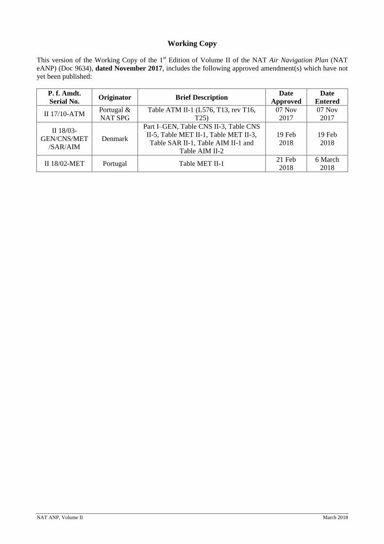
This version of the Working Copy of the 1st Edition of Volume II of the NAT Air Navigation Plan (NAT
eANP) (Doc 9634), dated November 2017, includes the following approved amendment(s) which have not
yet been published:
P. f. Amdt.
Serial No. Originator Brief Description
Date
Approved
Date
Entered
II 17/10-ATM Portugal &
NAT SPG
Table ATM II-1 (L576, T13, rev T16,
T25)
07 Nov
2017
07 Nov
2017
II 18/03-
GEN/CNS/MET
/SAR/AIM
Denmark
Part I–GEN, Table CNS II-3, Table CNS
II-5, Table MET II-1, Table MET II-3,
Table SAR II-1, Table AIM II-1 and
Table AIM II-2
19 Feb
2018
19 Feb
2018
II 18/02-MET Portugal Table MET II-1 21 Feb
2018
6 March
2018

NAT ANP, Volume II March 2018
Page i
NAT ANP, Volume II March 2018
TABLE OF CONTENTS
PART 0 — Introduction ............................................................................................................................. …0-1
PART I — General Planning Aspects (GEN) ............................................................................................. …I-1
General Regional Requirements
Table GEN II-1 — Homogeneous areas and major traffic flows identified in the NAT Region
Specific Regional Requirements
PART II — Aerodromes / Aerodrome Operations (AOP) ........................................................................ …II-1
General Regional Requirements
Table AOP II-1 — Requirements and capacity assessment in international aerodromes in the
NAT Region
Specific Regional Requirements
PART III — Communications, Navigation and Surveillance (CNS) ...................................................... …III-1
General Regional Requirements
Table CNS II-1 — AFTN Plan
Table CNS II-2 — Required ATN Infrastructure Routing Plan
Table CNS II-3 — ATS Direct Speech Circuits Plan
Table CNS II-4 — HF Network designators applicable for the Region (not applicable)
Specific Regional Requirements
Table CNS II-5 —Aeronautical Mobile Service and AMSS
Table CNS II-6 —ATS Data Circuits Plan
Table CNS II-7 —Radio Navigation Aids
Table CNS II-8 —Surveillance Systems
PART IV — Air Traffic Management (ATM) ........................................................................................ …IV-1
General Regional Requirements
Specific Regional Requirements
Table ATM II-1 — NAT Region ATS Routes
PART V — Meteorology (MET) ............................................................................................................. …V-1
General Regional Requirements
Table MET II-1 — Meteorological watch offices
Table MET II-2 — Aerodrome meteorological offices
Table MET II-3 — HF VOLMET broadcast
Specific Regional Requirements
Table MET II-4-Surface and Upper Air Synoptic Networks and Observations
PART VI — Search and Rescue Services (SAR) .................................................................................... …VI-1
General Regional Requirements
Table SAR II-1 — Rescue Coordination Centres (RCCs) and Rescue Sub-centres (RSCs) in the
NAT Region
Chart SAR II-1 — Rescue Coordination Centres (RCCs) and Rescue Sub-Centres (RSCs) in the
NAT Region
Specific Regional Requirements
Page ii
NAT ANP, Volume II March 2018
PART VII — Aeronautical Information Management (AIM) ............................................................... …VII-1
General Regional Requirements
Table AIM II-1 - Responsibility for the provision of AIS/AIM Facilities and Services in the
NAT Region
Table AIM II-2 - Production responsibility for sheets of the World Aeronautical Chart — ICAO
1: 1 000 000 or Aeronautical Chart — ICAO 1: 500 000
Specific Regional Requirements
Page 0-1
NAT ANP, Volume II Part 0 (Intro) November 2017
NAT ANP, VOLUME II
PART 0 – INTRODUCTION
1. GENERAL
1.1 The background to the publication of ANPs in three volumes is explained in the Introduction
in Volume I. The procedure for amendment of Volume II is also described in Volume I.
1.2 Volume II contains dynamic plan elements related to:
a) the assignment of responsibilities to States for the provision of aerodrome and air navigation
facilities and services; and
b) the mandatory requirements related to aerodrome and air navigation facilities and services to
be implemented by States in accordance with regional air navigation agreements.
1.3 Volume II does not list all facilities in the region but only those required for international
civil aviation operations in accordance with regional air navigation agreements. A regional air navigation
agreement indicates a commitment on the part of the State(s) concerned to implement the requirement(s)
specified. Documents from the Integrated Aeronautical Information Package and other publications should
be consulted for information on additional facilities and for operational information in general. Detailed
guidance material or concepts, complementary to the material in Volumes I, II and III are contained in
documents that are referenced as NAT Documents.
2. MANAGEMENT OF REGIONAL AIR NAVIGATION PLANS
2.1 The elements in Volume II are reviewed by the North Atlantic Systems Planning Group
(NAT SPG) in accordance with its schedule of meetings, in consultation with provider and user States and
with the assistance of the ICAO European and North Atlantic (EUR/NAT) Regional Office.
2.2 The information on States’ facilities and services included in Volume II, should be updated
following the process of regional air navigation agreements.
2.3 The development and maintenance of region-specific documents that provide detailed
guidance material or concepts that are complementary to the material in Volumes I, II and III is the
responsibility of the NAT SPG.
Page I-1
NAT ANP, Volume II Part I GEN February 2018
NAT ANP, VOLUME II
PART I – GENERAL PLANNING ASPECTS (GEN)
1. INTRODUCTION
1.1. The material in this part of Volume II of ANP is applicable to one or more parts of the ANP.
It should be taken into consideration in the overall planning process for the NAT Region.
2. GENERAL REGIONAL REQUIREMENTS
2.1. To facilitate air navigation systems planning and implementation, homogenous ATM areas
and/or major traffic flows/routing areas have been defined for the Region. While these areas of routing do
not encompass all movements in the Region, they include the major routes. This includes the domestic
flights in that particular area of routing.
Homogeneous ATM area
2.2. A homogeneous ATM area is an airspace with a common ATM interest, based on similar
characteristics of traffic density, complexity, air navigation system infrastructure requirements or other
specified considerations. In such an ATM area a common detailed plan will foster the implementation of
interoperable ATM systems. Homogeneous ATM areas may extend over States, specific portions of States,
or groupings of States. They may also extend over large oceanic and continental areas. They are considered
areas of shared interest and requirements.
2.3. The method of identifying homogeneous ATM areas involves consideration of the varying
degrees of complexity and diversity of the worldwide air navigation infrastructure. Based on these
considerations, planning could best be achieved at the global level if it was organized based on ATM areas
of common requirements and interest, taking into account traffic density and the level of sophistication
required.
Major traffic flows/routing areas
2.4. A major traffic flow refers to a concentration of significant volumes of air traffic on the same
or proximate flight trajectories. Major traffic flows may cross several homogeneous ATM areas with
different characteristics.
2.5. A routing area encompasses one or more major traffic flows, defined for the purpose of
developing a detailed plan for the implementation of ATM systems and procedures. A routing area may cross
several homogeneous ATM areas with different characteristics. A routing area specifies common interests
and requirements of underlying homogeneous areas, for which a detailed plan for the implementation of
ATM systems and procedures either for airspace or aircraft will be specified.
2.6. The homogeneous ATM areas and major traffic flows/routing areas identified are given in
Table GEN II-1.
Page I-2
NAT ANP, Volume II Part I GEN February 2018
3. SPECIFIC REGIONAL REQUIREMENTS
Specific Regional Arrangements
3.1 Under the Agreement on the Joint Financing of Certain Air Navigation Services in
Greenland (1956) and the Agreement on the Joint Financing of Certain Air Navigation Services in Iceland
(1956) (referred to as the DEN/ICE Agreements), Iceland and Denmark agreed to provide air traffic control,
communications and meteorology services for civil aircraft flying through the Reykjavik and Nuuk FIRs.
However, the dynamic nature of the volume of the daily flows of traffic through these FIRs require the
provision of permanent design capacities to cover the maximum potential traffic flows. Such services must
be maintained and staffed even through the majority of days when meteorological conditions resulted in the
major NAM/EUR traffic flows being further south, primarily through Shanwick and Gander Oceanic
airspaces. Therefore, to support the financing of this level of services and facilities, it was agreed that cost
recovery should be spread over the total traffic volume transiting the NAT Region north of 45th parallel
North (i.e including additionally all traffic through Shanwick and Gander Oceanic FIRs). A portion of the
costs are shared amongst the contracting States, in proportion to the benefits derived from the services.
Currently, 24 States with civil aircraft flying across the North Atlantic are parties to these Agreements,
including the two provider States, Denmark and Iceland. All States whose aircraft make a significant number
of North Atlantic crossings are invited to adhere to these Agreements.
3.2 In the NAT Region, there are a number of operationally driven agreements to delegate ATC
and CNS provision:
3.2.1 In portions of the Shanwick OCA, ATS provisions is delegated to Shannon ACC (NOTA &
SOTA) and to Brest ACC (BOTA). In these areas the availability of continental CNS facilities (including
radar surveillance and VHF DCPC) enables enhanced capacities for the efficient handling of Oceanic-
Continental transitioning traffic.
3.2.2 With the same rationale, a similar arrangement exists in the Gander OCA where ATS
provision (FL290 – 600) is delegated to Gander Domestic ACC (GOTA).
3.2.3 In the southern portion of the Nuuk FIR (above FL195) ATS provision is delegated to
Gander OCA, thereby avoiding multiple transfers of control of the predominant East/West flow of flights
through that airspace.
3.2.4 In the remaining northern portion of the Nuuk FIR (above FL195) ATS provision is
delegated to Reykjavik OAC. This arrangement reduces centre-to-centre co-ordination requirements and
allows for the a more cost-effective provision of services.
3.2.5 The control of traffic routing via 600000.0N 0100000.0W and 610000.0N 0100000.0W
between the Scottish and Reykjavik FIRs is delegated by Shanwick OAC to Reykjavik OAC, thereby
reducing the requirement for additional centre-to-centre co-ordination.
3.3 The NAT Central Monitoring Agency (CMA) is responsible for the monitoring and reporting
of certain aspects of operations in the NAT Region. The NAT CMA was initially established in 1985 by the
ICAO North Atlantic System Planning Group (NATSPG) to support the preparation and introduction of
RVSM in the North Atlantic (NAT) Region, and thereafter to perform a database assessment and provide
assurance of continuing system safety and integrity. The operating costs of the CMA and the maintenance of
the Height Monitoring Unit are recovered from ICAO under a Joint Financing Arrangement signed in 1995
by the governments of several NATSPG Member States: Canada, Iceland, Ireland, Portugal, the United
Kingdom, United States and ICAO. The CMA is located adjacent to the Shanwick Oceanic Area Control
Centre, in Prestwick, Scotland in accommodation provided by NATS on behalf of the United Kingdom.
While functionally autonomous from its host State the CMA can access specialist support and ATC
expertise.
Page I-3
NAT ANP, Volume II Part I GEN February 2018
TABLE GEN II-1 - HOMOGENEOUS AREAS AND MAJOR TRAFFIC FLOWS IDENTIFIED IN THE NAT
REGION
EXPLANATION OF TABLE
Column
1 Area of routing (AR) Sequential number of area of routing
2 Homogeneous Areas and/or Traffic flows
Brief description and/or name
3 FIRs involved List of FIRs concerned
4 Type of area covered Brief description of type of area, examples: Oceanic or Continental High or low density Oceanic en-route or Continental en-route
5 Remarks Homogeneous Area and Major Traffic Flow and Region(s) concerned
Area of
routing
(AR)
Homogeneous
Areas and/or
Traffic flows
FIRs involved Type of area
covered Remarks
1 2 3 4 5
AR-1
NAT High level
airspace (NAT
MNPSA/HLA)
Bodo Oceanic,
Gander Oceanic, New
York Oceanic East,
Reykjavik, Santa
Maria Oceanic ,
Shanwick Oceanic
High density Oceanic
en-route
Above FL285. Flights between EUR and
NAM/CAR.
ATM efficiency is enhanced by some
delegations of airspace & ATS
provision.
AR-2 Low Level
Airspace
Bodo Oceanic,
Gander Oceanic, New
York Oceanic East,
Reykjavik, Santa
Maria Oceanic ,
Shanwick Oceanic
Low density Oceanic
en-route
Below FL285
Transatlantic and Regional Flights.
Mostly General Aviation.
AR-3
Northern
Oceanic
Transition Area
(NOTA)
Shanwick Oceanic
High density Oceanic
en-route &
Oceanic/Continental
transitions
Flights transitioning between
Shanwick Oceanic and Scottish &
Shannon FIRs.
ATC & CNS services delegated to
Shannon ACC.
AR-4
Shannon
Oceanic
Transition Area
(SOTA)
Shanwick Oceanic
High density Oceanic
en-route &
Oceanic/Continental
transitions
Flights transitioning between
Shanwick Oceanic and London &
Brest FIRs and Flights transitioning
to Tango Routes.
ATC & CNS services delegated to
Shannon ACC.
AR-5
Brest Oceanic
Transition Area
(BOTA)
Shanwick Oceanic
Medium density
Oceanic en-route &
Oceanic/Continental
transitions
Flights transitioning between
Shanwick Oceanic and Brest FIR.
ATC & CNS services delegated to
Brest ACC.
AR-6
Gander Oceanic
Transition Area
(GOTA)
Gander Oceanic
High density Oceanic
en-route &
Oceanic/Continental
transitions
Flights transitioning between Gander
Oceanic and Montreal and Gander
Domestic FIRs.
FL290-FL600.
ATC & CNS services delegated to
Gander Domestic ACC.
____________________

Page II-1
NAT ANP, Volume II Part II AOP November 2017
NAT ANP, VOLUME II
PART II – AERODROMES / AERODROME OPERATIONS (AOP)
1. INTRODUCTION
1.1 This part of the NAT ANP, Volume II, complements the provisions in ICAO SARPs and
PANS related to aerodrome design and operations (AOP). It contains dynamic plan elements related to the
assignment of responsibilities to States for the provision of AOP facilities and services within a specified
area in accordance with Article 28 of the Convention on International Civil Aviation (Doc 7300); and
mandatory requirements related to AOP facilities and services to be implemented by States in accordance
with regional air navigation agreements. Such agreement indicates a commitment on the part of the State(s)
concerned to implement the requirement(s) specified.
2. GENERAL REGIONAL REQUIREMENTS
2.1 Table AOP II-1 contains the list of facilities and services to be provided by the State
concerned at each aerodrome that is listed in Table AOP I-1 in Volume I. Table AOP II-1 shows the
operational requirements at each aerodrome to be considered in planning the facilities and services for safe
and efficient aircraft operations.
Visual aids for low visibility aerodrome operations
2.2 At aerodromes where there is a requirement to conduct low visibility operations, the
appropriate visual and non-visual aids should be provided.
Non-precision approach aids
2.3 Where required by the topographic and/or environmental situation of an aerodrome,
improved track guidance during departure and/or approach by specific non-visual and/or visual aids should
be provided even if such aids would not normally be required in accordance with the SARPs.
Reduced runway declared distances for take-off
Note. — In the following operational requirements the term “intersection” is used to cover both intersection
and junction concepts.
2.4 The reduced runway declared distances for take-off, as for those used for full runway
declared distances, should consist of take-off run available (TORA), take-off distance available (TODA) and
accelerate-stop distance available (ASDA).
2.5 The datum-line from which the reduced runway declared distances for take-off should be
determined is defined by the intersection of the downwind edge of the specific taxiway with the runway
edge. The loss, if any, of runway length due to alignment of the aircraft prior to take-off should be taken into
account by the operators for the calculation of the aircraft’s take-off weight.
2.6 Intersections used as intermediate take-off positions should be identified by the “taxiway
designator” to which the datum-line of the associated reduced runway declared distance for take-off refers.
2.7 At each international aerodrome, specific minima visibility for take-off should be
established, regulating the use of intersection take-off positions. These minima should permit the appropriate
ATC unit to maintain a permanent surveillance of the ground movement operations, and the flight crews to
Page II-2
NAT ANP, Volume II Part II AOP November 2017
constantly secure their position on the manoeuvring area, so as to exclude any potential risk of confusion as
to the identification of the aircraft and intersections used for take-off. The minima should be consistent with
the surface movement guidance and control system (SMGCS) provided at the aerodrome concerned.
2.8 The provision of marking and lighting aids together with signs should ensure the safe control
and guidance of aircraft towards and at take-off intersections appropriate to the minima visibility criteria
retained. At the runway holding position of the associated intersection take-off position, such signs should
indicate the runway heading and the remaining TORA in metres.
2.9 At aerodromes regularly used by international commercial air transport, take-offs from
runway/taxiway intersections may be justified for the following reasons:
a) runway capacity improvement;
b) taxi routes distances reduction;
c) noise alleviation; and
d) air pollution reduction.
2.10 The appropriate authorities should, upon prior consultation with aircraft operators, agree on
the selection of suitable intermediate intersection take-off positions along the runway(s). Accordingly,
authorities should determine the reduced runway declared distances for take-off associated with each
selected intersection take-off position and establish the specific ATC rules and operational
procedures/limitations. Such provisions should be published in the State aeronautical information
publications (AIP).
Aerodrome capacity management
2.11 As an integral part of the air navigation system, the aerodrome should provide the needed
ground infrastructure including, inter alia, lighting; taxiways; runway, including exits; aprons and precise
surface guidance to improve safety and to maximize aerodrome capacity in all weather conditions. An
efficient aerodrome capacity planning and management should include:
a) reduction of runway occupancy time;
b) the capability to safely manoeuvre in all weather conditions whilst maintaining capacity;
c) precise surface guidance to and from a runway required in all conditions; and
d) availability of information on the position (to an appropriate level of accuracy) and intent
of all vehicles and aircraft operating on the movement area for the appropriate ATM
community members.
2.12 States should ensure that adequate consultation and, where appropriate, cooperation between
airport authorities and users/other involved parties are implemented at all international aerodromes to satisfy
the provisions of aerodrome capacity assessment and requirement.
2.13 When international aerodromes are reaching designed operational capacity, a better and
more efficient utilization of existing runways, taxiways and aprons is required. Runway selection procedures
and standard taxi routes at aerodromes should ensure an optimum flow of air traffic with a minimum of delay
and a maximum use of available capacity. They should also, if possible, take account of the need to keep
taxiing times for arriving and departing aircraft as well as apron occupancy time to a minimum. The airport
collaborative decision making (A-CDM) concept should be implemented to improve airport capacity as early
as possible.
Aerodrome capacity assessment and requirement
2.14 The declared capacity/demand condition at aerodromes should be periodically reviewed in
terms of a qualitative analysis for each system component and, when applicable, the result of the qualitative
assessment upon mutual agreement be used for information.
Page II-3
NAT ANP, Volume II Part II AOP November 2017
2.15 The future capacity/demand, based on a forecast for the next five years, should be agreed
upon after close cooperation between aerodrome authorities and affected users.
2.16 Operators should consult with aerodrome authorities when future plans indicate a significant
increased requirement for capacity resulting in one of the elements reaching a limiting condition.
2.17 Aerodrome capacity should be assessed by aerodrome authorities in consultation with the
parties involved for each component (terminal/apron/aircraft operations) using agreed methods and criteria
for level of delays.
2.18 Where restrictions in aerodrome capacity are identified, a full range of options for their
reduction or removal should be evaluated by the aerodrome authority, in close cooperation with the operators
and other involved parties. Such options should include technical/operational/procedural and environmental
improvements and facility expansion.
2.19 At many aerodromes, airspace capacity has influence on the aerodrome capacity. If the
declared capacity of a specified airspace has influence on aerodrome operations, this should be indicated and
action undertaken to reach a capacity in this airspace corresponding to the aerodrome capacity.
2.20 The possibility of overcoming capacity limitations should also take the use of other
aerodromes in the vicinity into consideration.
Closure of regular aerodromes
2.21 When a regular aerodrome is to be closed, States should ensure that sufficient alternate
aerodromes remain open to provide for the safety and efficiency of aircraft approaching the regular
aerodrome that may be required to divert to an alternate.
Scheduling aerodrome maintenance
2.22 States, when planning major aerodrome maintenance work that would affect the regularity of
international aircraft operations, should consider the need to notify aircraft operators sufficiently in advance
prior to undertaking the scheduled work.
3. SPECIFIC REGIONAL REQUIREMENTS
3.1 None.
–––––––––––––––––––
Page II-4
NAT ANP, Volume II Part II AOP November 2017
Table AOP II-1 – REQUIREMENTS AND CAPACITY ASSESSMENT IN INTERNATIONAL
AERODROMES IN THE NAT REGION
EXPLANATION OF THE TABLE
Note: Columns 3 to 5 for physical characteristics relate to runways and taxiways. The physical
characteristics of taxiways and aprons should be compatible with the aerodrome reference code (Column 3)
and appropriate for the runways with which they are related.
Column
1 Name of the city and aerodrome, preceded by the location indicator.
Note 1— When the aerodrome is located on an island and no particular city or town is served
by the aerodrome, the name of the island is included instead of a city.
Designation of the aerodrome as:
RS — international scheduled air transport, regular use;
RNS — international non-scheduled air transport, regular use;
AS — international scheduled air transport, alternate use; and
ANS — international non-scheduled air transport, alternate use;
2 Required rescue and firefighting service (RFF). The required level of protection expressed by
means of an aerodrome RFF category number, in accordance with Annex 14, Volume I, 9.2.
3 Aerodrome reference code (RC). The aerodrome reference code for aerodrome characteristics
expressed in accordance with Annex 14, Volume I, chapter 1. The code letter or number within
an element selected for design purposes is related to the critical aeroplane characteristics for
which the facilities are provided.
4 Runway Designation numbers
5 Type of each of the runways to be provided. The types of runways, as defined in Annex 14,
Volume I, Chapter 1, are:
NINST — non-instrument runway;
NPA — non-precision approach runway;
PA1 — precision approach runway, Category I;
PA2 — precision approach runway, Category II;
PA3 — precision approach runway, Category III.
6 Remarks. Additional information including critical design aircraft selected for determining RC,
critical aircraft selected for determining the RFF category and critical aircraft for pavement
strength. Only one critical aircraft type is shown if it is used to determine all the above three
elements: otherwise different critical aircraft types need to be shown for different elements.
__________________
Page II-5
NAT ANP, Volume II Part II AOP November 2017
Table AOP II-1 - REQUIREMENTS AND CAPACITY ASSESSMENT IN INTERNATIONAL AERODROMES IN THE NAT REGION
City/Aerodrome/ Designation RFF
Category Physical characteristics Remarks
RC RWY No. RWY Type
1 2 3 4 5 6
DENMARK (Faeroes)
EKVG VAGAR Vagar RS 6 3C 12 30
NPA PA-1
DENMARK (Greenland)
BGAA AASIAAT Aasiaat ANS 5 1C 11 29
NPA
BGBW NARSARSUAQ Narsarsuaq RS 7 4D 07 25
NPA
BGCO NERLERIT INAAT Nerlerit Inaat RS 5 2C 18 36
NPA
BGGH NUUK Nuuk RS 5 2C 05 23
NPA
BGJN ILULISSAT Ilulissat RS 5 2C 07 25
NPA
BGKK KULUSUK Kulusuk RS 5 2C 11 29
NPA
BGMQ MANIITSOQ Maniitsoq ANS 5 1C 16 34
NPA
BGPT PAAMIUT Paamiut ANS 5 1C 17 35
NPA
BGQQ QAANAAQ Qaanaaq ANS 5 2C 36 18
NPA
BGSF KANGERLUSSUAQ Kangerlussuaq RS 5 4D 09 27
NPA NINST
BGSS SISIMIUT Sisimiut ANS 5 1C 14 32
NPA
BGTL THULE Thule RNS 7 - 08T 26T
Military
BGUK UPERNAVIK Upernavik ANS 5 1C 05 23
NPA
Page II-6
NAT ANP, Volume II Part II AOP November 2017
City/Aerodrome/ Designation RFF
Category Physical characteristics Remarks
RC RWY No. RWY Type
BGUQ UUMMANNAQ/QAARSUT Uummannaq/Qaarsut ANS 5 2C 16 34
NPA
ICELAND
BIAR AKUREYRI Akureyri AS 5-7 4D 01 19
PA-1 NPA
BIEG EGILSSTADIR Egilsstadir AS 5-7 4D 04 22
PA-1 NPA
BIKF KEFLAVIK Keflavik RS 9 4E 11 29 02 20
PA-2 PA-1 PA-1 PA-2
BIRK REYKJAVIK Reykjavik RS 7 3D 01 19 13 31 06 24
NPA PA-1 NPA NPA NINST NINST
NORWAY
ENSB SVALBARD Svalbard-Longyear RNS 6 4C 10 28
PA-1 NPA
PORTUGAL (Acores)
LPPD PONTA DELGADA Ponta Delgada RS 7 (8-9 PA)
4E 12 30
NINST PA-1
LPAZ SANTA MARIA Santa Maria RS 6 (7-9 PA)
4E 36 18
NPA PA-1
__________________
Page III-1
NAT ANP, Volume II Part III CNS November 2017
NAT ANP, VOLUME II
PART III – COMMUNICATIONS, NAVIGATION AND SURVEILLANCE (CNS)
1. INTRODUCTION
1.1 This part of the NAT ANP, Volume II, complements the provisions in ICAO SARPs and
PANS related to communication, navigation and surveillance (CNS). It contains dynamic plan elements
related to the assignment of responsibilities to States for the provision of CNS facilities and services within a
specified area in accordance with Article 28 of the Convention on International Civil Aviation (Doc 7300);
and mandatory requirements related to CNS facilities and services to be implemented by States in
accordance with regional air navigation agreements. Such agreement indicates a commitment on the part of
the State(s) concerned to implement the requirement(s) specified.
2. GENERAL REGIONAL REQUIREMENTS
Communications
Aeronautical Fixed Service (AFS)
2.1 The aeronautical fixed service should comprise the following systems and applications that
are used for ground-ground (i.e. point-to-point and/or point-to-multipoint) communications in the
international aeronautical telecommunication service:
a) ATS direct speech circuits and networks;
b) meteorological operational circuits, networks and broadcast systems, including World Area
Forecast System – Internet File Service (WIFS) and/or Satellite Distribution System for
Information Relating to Air Navigation (SADIS);
c) the aeronautical fixed telecommunications network (AFTN);
d) the common ICAO data interchange network (CIDIN);
e) the air traffic services (ATS) message handling services (AMHS); and
f) the inter-centre communications (ICC).
2.2 To meet the data communication requirements, a uniform high-grade aeronautical network
should be provided, based on the aeronautical telecommunication network (ATN), taking into account the
existence and continuation of current networks.
2.3 Contingency procedures should be in place to ensure that, in case of a communication centre
breakdown, all the parties concerned are promptly informed of the prevailing situation. All possible
arrangements should be made to ensure that, in case of breakdown of a communications centre or circuit, at
least high-priority traffic continues to be handled by appropriate means.
2.4 AFS planning should permit flexibility in detailed development and implementation. The
required AFTN Stations and Centres are listed in the AFTN Plan in Table CNS II-1.
The Aeronautical Telecommunication Network (ATN)
2.5 The ATN should be able to:
a) support applications carried by the existing networks;
b) support gateways enabling inter-operation with existing networks; and
c) support ground-ground communications traffic associated with air-ground data link
applications.
Page III-2
NAT ANP, Volume II Part III CNS November 2017
2.6 The ATN should make optimum use of dedicated bilateral/multilateral aeronautical links and
other communication means commensurate with the operational Quality of Service (QoS) requirements.
2.7 The implementation of the ATN should take into account the need for cost-effective
evolution in terms of network capacity, requirements and time-frame and allow for a progressive transition
from existing communication networks and services to a uniform, harmonised and integrated
communications infrastructure, capable of supporting the implementation of future aeronautical services
such as Flight and Flow Information in a Collaborative Environment (F-FICE), System-Wide Information
Management (SWIM) applications, etc.
2.8 In case means other than dedicated bilateral links are used by the ATN, States should ensure
that service level agreements (SLA) are met in terms of implementation priority, high availability, priority in
restoration of service and appropriate levels of security.
2.9 The ATN should provide for interregional connections to support data exchange and mobile
routing within the global ATN.
2.10 In planning the ATN, provisions should be made, where required, for interfacing with other
international networks. The Required ATN Infrastructure Routing Plan is described under Table CNS II-2.
Network services
2.11 The Internet Society (ISOC) communications standards for the Internet Protocol Suite (IPS)
should be used for the implementation of AMHS.
2.12 The migration from legacy bit-oriented protocols such as X.25 Protocol suite to IPS should
be planned.
2.13 The migration of international or sub-regional ground networks to the ATN based on Internet
Protocol (IP) to support AFS communication requirements, while reducing costs, should be planned.
2.14 States should ensure that the solutions provided for the implementation of the ATN meet the
air traffic management and aeronautical fixed service requirements. Such requirements should consist of:
a) Performance requirements: availability, continuity, integrity, monitoring and alerting criteria
per data flow. In the case where a required communication performance (RCP) is globally
prescribed, requirements derived from RCP should be stated;
b) Interoperability requirements;
c) Safety and security requirements, duly derived after the identification of operational hazards
and threats, and allocation of objectives; and
d) Implementation process requirements (creation, test, migration, upgrades, priority in
restoration of service, termination).
Network management
2.15 An ICAO centralised off-line network management service is provided to participating
AFTN/AMHS centres in the NAT Region under the ATS Messaging Centre (AMC).
2.16 In the case of integrated communications services procured and shared by several States,
organizational provisions should allow for the planning and performing of the management of technical
performance, network configuration, fault, security, cost division/allocation, contract, orders and payment.
Specific air traffic management (ATM) requirements
2.17 Where ATS speech and data communication links between any two points are provided, the
engineering arrangements should be such as to avoid the simultaneous loss of both circuits. The required
ATS direct speech circuits plan is detailed under Table CNS II-3.
2.18 Special provisions should be made to ensure a rapid restoration of ATS speech circuits in
case of outage, as derived from the performance and safety requirements.
2.19 Data circuits between ATS systems should provide for both high capacity and message
integrity.
Page III-3
NAT ANP, Volume II Part III CNS November 2017
2.20 The Inter-Centre Communication (ICC), consisting of ATS Inter-facility Data
Communication (AIDC) application and the Online Data Interchange (OLDI) application, should be used for
automated exchange of flight data between ATS units to enhance the overall safety of the ATM operation
and increase airspace capacity.
2.21 Where Voice over IP is planned or implemented between ATS units for voice
communications, it should meet the ATS requirements. When data and voice are multiplexed, particular
attention should be paid to the achievement of the ATM performance and safety requirements.
Specific meteorological (MET) requirements
2.22 The increasing use of the GRIB (Gridded Binary or General Regularly-distributed
Information in Binary form) and BUFR (Binary Universal Form for the Representation of meteorological
data) code forms for the dissemination of the upper wind and temperature and significant weather forecasts
and the planned transition to digital form using extensible markup language (XML)/geography markup
language (GML) for the dissemination of OPMET data should be taken into account in the planning process
of the ATN.
2.23 In planning the ATN, account should be taken of changes in the current pattern of
distribution of meteorological information resulting from the increasing number of long-range direct flights
and the trend towards centralized flight planning.
Specific aeronautical information management (AIM) requirements
2.24 The aeronautical fixed service (AFS) should meet the requirements to support efficient
provision of aeronautical information services through appropriate connections to area control centres
(ACCs), flight information centres (FICs), aerodromes and heliports at which an information service is
established.
Aeronautical Mobile Service (AMS)
2.25 To meet the air-ground data communication requirements, a high-grade aeronautical network
should be provided based on the ATN, recognising that other technologies may be used as part of the
transition. The network needs to integrate the various data links in a seamless fashion and provide for end-
to-end communications between airborne and ground-based facilities.
2.26 Whenever required, use of suitable techniques on VHF or higher frequencies should be
made. The required HF network designators applicable for the NAT Region are in the HF Management
Guidance Material (NAT Doc 003).
2.27 Aerodromes having a significant volume of International General Aviation (IGA) traffic
should also be provided with appropriate air-ground communication channels.
Air-Ground Data Link Communications
2.28 A Strategy for the harmonised implementation of the data link communications in the NAT
Region should be developed based on the Global Operational Data Link Document (GOLD) adopted by
ICAO Regions and the Aviation System Block Upgrade (ASBU) methodology.
2.29 Where applicable, controller-pilot data link communications (CPDLC), based on ATN VDL
data link Mode 2 (VDL2) and/or FANS-1/A, should be implemented for air-ground data link
communications.
2.30 Partial or divergent aircraft data link evolutions that result in excluding messages from
aircraft systems should not be pursued. Interim steps or phases toward full implementation of the common
technical definition in ground systems should only be pursued on a regional basis, after coordination between
all States concerned.
2.31 Harmonization of operational procedures for implementation of the above packages is
essential. States, Planning and Implementation Regional Groups (PIRGs) and air navigation services
Page III-4
NAT ANP, Volume II Part III CNS November 2017
providers should adopt common procedures to support seamless ATS provision across FIR boundaries,
rather than each State or Region developing and promulgating unique procedures for common functions.
Required Communication Performance (RCP)
2.32 The Required Communication Performance (RCP) concept characterizing the performance
required for communication capabilities that support ATM functions without reference to any specific
technology should be applied wherever possible.
2.33 States should determine, prescribe and monitor the implementation of the RCP in line with
the provisions laid down in the ICAO Manual on Required Communication Performance (Doc 9869).
Navigation
Navigation Infrastructure
2.34 The navigation infrastructure should meet the requirements for all phases of flight from take-
off to final approach and landing.
Note: Annex 10 to the Convention on International Civil Aviation—Aeronautical
Telecommunications, Volume I — Radio Navigation Aids, Attachment B, provides the strategy for
introduction and application of non-visual aids to approach and landing.
2.35 The NAT Minimum Navigation Performance Specification (MNPS) to PBN Transition Plan
provides guidance to air navigation service providers, airspace operators and users, regulators, and
international organizations, on the expected evolution of the NAT air navigation system in order to allow
planning of airspace changes, enabling ATM systems and aircraft equipage. It takes due account of the
operational environment of the NAT Region.
PBN Transition Strategy
2.36 During transition to performance-based navigation (PBN), sufficient ground infrastructure
for conventional navigation systems should remain available. Before existing ground infrastructure is
considered for removal, users should be given reasonable transition time to allow them to equip
appropriately to attain a performance level equivalent to PBN. States should approach removal of existing
ground infrastructure with caution to ensure that safety is not compromised. This should be guaranteed by
conducting safety assessments and consultations with the users.
Use of specific navigation aids
2.37 Where, within a given airspace, specific groups of users have been authorized by the
competent authorities to use special aids for navigation. The respective ground facilities should be located
and aligned so as to provide for full compatibility of navigational guidance with that derived from the
SARPs.
2.38 States should ensure and oversee that service providers take appropriate corrective measures
promptly whenever required by a significant degradation in the accuracy of navigation aids (either space
based or ground based or both) is detected.
Surveillance
2.40 An important element of modern air navigation infrastructure required to manage safely
increasing levels and complexity of air traffic is aeronautical surveillance systems.
2.41 When operating Mode S radars, States should coordinate with their respective ICAO
Regional Office the assignment of their corresponding interrogator identifier (II) codes and surveillance
identifier (SI) codes, particularly where areas of overlapping coverage will occur.
Page III-5
NAT ANP, Volume II Part III CNS November 2017
Frequency Management
Aeronautical Mobile Service (AMS)
2.42 Frequencies should be assigned to all VHF aeronautical mobile service (AMS) facilities in
accordance with the principles laid out in Annex 10, Volume V and ICAO Handbook on Radio Frequency
Spectrum Requirements for Civil Aviation (Doc 9718) Volumes I and II, and take into account:
a) agreed geographical separation criteria based on 25 kHz or 8.33 kHz interleaving between
channels;
b) agreed geographical separation criteria for the implementation of VDL services;
c) the need for maximum economy in frequency demands and in radio spectrum utilization; and
d) a deployment of frequencies which ensures that international services are planned to be free
of interference from other services using the same band.
2.43 The priority order to be followed in the assignment of frequencies to service is:
a) ATS channels serving international services (ACC, APP, TWR, FIS);
b) ATS channels serving national purposes;
c) channels serving international VOLMET services;
d) channels serving ATIS and PAR; and
e) channels used for other than ATS purposes.
2.44 The criteria used for frequency assignment planning for VHF AMS facilities serving
international requirements should, to the extent practicable, also be used to satisfy the need for national VHF
AMS facilities.
2.45 Special provisions should be made, by agreement between the States concerned, for the
sharing and the application of reduced protection of non-ATS frequencies in the national sub-bands, so as to
obtain a more economical use of the available frequency spectrum consistent with operational requirements.
2.46 States should ensure that no air/ground frequency is utilized outside its designated
operational coverage and that the stated operational requirements for coverage of a given frequency can be
met for the transmission sites concerned, taking into account terrain configuration.
Radio navigation aids for Aeronautical Radio Navigation Services (ARNS)
2.47 Frequencies should be assigned to all radio navigation facilities taking into account agreed
geographical separation criteria to ILS localizer, VOR and GBAS, X and Y channels to DME, in accordance
with the principles laid out in Annex 10, Volume V and ICAO Handbook on Radio Frequency Spectrum
Requirements for Civil Aviation (Doc 9718) Volumes I and II. Also, the need for maximum economy in
frequency demands and in radio spectrum utilization and a deployment of frequencies which ensures that
international services are planned to be free of interference from other services using the same band, need to
be considered.
2.48 The principles used for frequency assignment planning for radio navigation aids serving
international requirements should, to the extent possible, also be used to satisfy the needs for national radio
aids to navigation.
Support to ICAO Positions for ITU World Radiocommunication Conferences (WRCs)
2.49 Considering the importance and continuous demand of the radio frequency spectrum and for
the protection of the current aeronautical spectrum and the allocation of new spectrum for the new services
and system to be implemented in civil air navigation, States and international organizations are to support
ICAO’s position at ITU World Radiocommunication Conferences (WRCs) and in regional and other
international activities conducted in preparation for ITU WRCs.
Note: The Handbook on Radio Frequency Spectrum Requirements for Civil Aviation (Doc
9718) Volume I, contains ICAO policy statements relevant to the aviation requirements for radio frequency
spectrum. The handbook is intended to assist States and ICAO in preparing for ITU WRCs.
Page III-6
NAT ANP, Volume II Part III CNS November 2017
3. SPECIFIC REGIONAL REQUIREMENTS
Communications
3.1 The NAT ground/ground data interchange should be in accordance with the procedures
specified in the NAT Common Coordination Interface Control Document (NAT CC ICD, Pan Regional
Interface Control Document (PAN ICD) for ATS Interfacility Data Communications (AIDC)
Aeronautical mobile service (AMS)
3.2 While current voice communication links such as HF and VHF will continue to be used
where necessary and appropriate, satellite data links are ultimately expected to provide high quality near
real-time information interchange in a major part of the NAT Region. In some parts of the Region, terrestrial
data links will be used. Thus, where a choice of alternative air/ground delivery systems exists, the system
should be designed to dynamically select the most economic data link routing consistent with efficiency and
operational requirements. The AMS to be provided in the NAT Region are shown in Table CNS II-5.
3.3 Where appropriate, CPDLC should be used in lieu of voice communications.
3.4 States should plan for the use of satellite voice for routine communications as an alternative
to HF voice. Overall system design should take into account planning for an orderly reduction of HF voice
services in the NAT Region.
3.5 For the data circuits between ATS systems referred to in 2.19 above, Table CNS II-6 shows
the ATS data circuits plan for the NAT Region.
Navigation
3.6 Table CNS II-7 details the radio navigation aids in the NAT Region.
Aeronautical Surveillance
3.7 Table CNS II-8 shows the ATS surveillance systems in the NAT Region.
3.8 Aeronautical surveillance in the NAT Region is performed by means of automated and voice
position reporting and by ATS surveillance in certain parts of the Region.
Regional data link performance monitoring
3.9 The NAT Data Link Monitoring Agency (DLMA) monitors data link performance in the
NAT Region on the basis of reports provided by States and airspace users.
__________________
Page III-7
NAT ANP, Volume II Part III CNS February 2018
TABLE CNS II- 1 - AERONAUTICAL FIXED TELECOMMUNICATIONS NETWORK
(AFTN) PLAN
EXPLANATION OF THE TABLE
Column
1 The AFTN Centres/Stations of each State are listed alphabetically. Each circuit appears
twice in the table. The categories of these facilities are as follows: M - Main AFTN COM Centre T - Tributary AFTN COM Centre S - AFTN Station 2 Category of circuit: M - Main trunk circuit connecting Main AFTN communication centres. T - Tributary circuit connecting Main AFTN communication centre and Tributary AFTN
Communications Centre. S - AFTN circuit connecting an AFTN Station to an AFTN Communication Centre. 3 Type of circuit provided: LTT/a - Landline teletypewriter, analogue (e.g. cable, microwave) LTT/d - Landline teletypewriter, digital (e.g. cable, microwave) LDD/a - Landline data circuit, analogue (e.g. cable, microwave) LDD/d - Landline data circuit, digital (e.g. cable, microwave) SAT/a/d - Satellite link, with /a for analogue or /d for digital 4 Circuit signalling speed in bits/s. 5 Circuit protocols 6 Data transfer code (syntax): ITA-2 - International Telegraph Alphabet No. 2 (5-unit Baudot code). IA-5 - International Alphabet No. 5 (ICAO 7-unit code). CBI - Code and Byte Independency (ATN compliant). 7 Remarks
State/Station Category
Requirement
Remarks Type
Signalling speed
Procotol Code
1 2 3 4 5 6 7
CANADA
Ottawa-M
Reykjavik M LDD/d 9600 CIDIN IA-5
London A M LDD/d 9600 X.25 IA-5
London C M LDD/d 9600 X.25 1A-5
Atlanta M LDD/d 9600 X.25 1A-5
Salt Lake City M LDD/d 9600 X.25 1A-5
FAEROES (Denmark)
Vagar-S
Copenhagen M LDD/d 9600
TCP/IP
via Internet
IA-5
GREENLAND (Denmark)
Nuuk-M
Copenhagen M LDD/d 9600 TCP/IP
via Internet
IA-5
Page III-8
NAT ANP, Volume II Part III CNS February 2018
State/Station Category
Requirement
Remarks Type
Signalling speed
Procotol Code
1 2 3 4 5 6 7
ICELAND
Reykjavik-M
Bergen M LDD/d 9600 CIDIN IA-5
London M LDD/d 9600 CIDIN IA-5
Ottawa M LDD/d 9600 CIDIN IA-5
IRELAND
London-A M LDD/a 9600 AFTN IA-5
London-B M LDD/a 9600 AFTN IA-5
Bordeaux M LDD/a 4800 AFTN IA-5
NORWAY
Bergen-M
Copenhagen M LDD/d 9600 CIDIN IA-5
PORTUGAL
Lisboa-M
Santa Maria M LDD/d 2400 AFTN IA-5
UNITED KINGDOM
London-M
Bergen M LDD/d 64000 CIDIN IA-5
Lisbon M LDD/d 9600 CIDIN IA-5
UNITED STATES
Atlanta M LDD/d 9600 X.25 IA-5
Salt Lake City M LDD/d 9600 X.25 IA-5
__________________
Page III-9
NAT ANP, Volume II Part III CNS February 2018
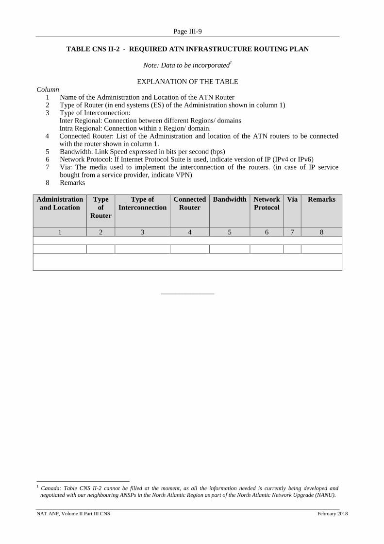
TABLE CNS II-2 - REQUIRED ATN INFRASTRUCTURE ROUTING PLAN
Note: Data to be incorporated1
EXPLANATION OF THE TABLE Column
1 Name of the Administration and Location of the ATN Router 2 Type of Router (in end systems (ES) of the Administration shown in column 1) 3 Type of Interconnection:
Inter Regional: Connection between different Regions/ domains Intra Regional: Connection within a Region/ domain.
4 Connected Router: List of the Administration and location of the ATN routers to be connected with the router shown in column 1.
5 Bandwidth: Link Speed expressed in bits per second (bps) 6 Network Protocol: If Internet Protocol Suite is used, indicate version of IP (IPv4 or IPv6) 7 Via: The media used to implement the interconnection of the routers. (in case of IP service
bought from a service provider, indicate VPN) 8 Remarks
Administration
and Location
Type
of
Router
Type of
Interconnection
Connected
Router
Bandwidth Network
Protocol
Via
Remarks
1 2 3 4 5 6 7 8
_______________
1 Canada: Table CNS II-2 cannot be filled at the moment, as all the information needed is currently being developed and
negotiated with our neighbouring ANSPs in the North Atlantic Region as part of the North Atlantic Network Upgrade (NANU).
Page III-10
NAT ANP, Volume II Part III CNS February 2018
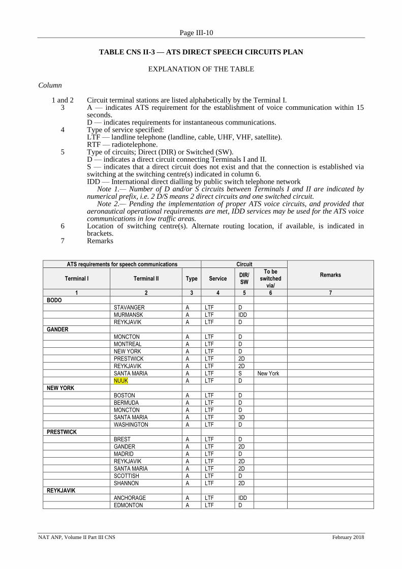
TABLE CNS II-3 — ATS DIRECT SPEECH CIRCUITS PLAN
EXPLANATION OF THE TABLE
Column 1 and 2 Circuit terminal stations are listed alphabetically by the Terminal I. 3 A — indicates ATS requirement for the establishment of voice communication within 15
seconds. D — indicates requirements for instantaneous communications. 4 Type of service specified: LTF — landline telephone (landline, cable, UHF, VHF, satellite).
RTF — radiotelephone. 5 Type of circuits; Direct (DIR) or Switched (SW). D — indicates a direct circuit connecting Terminals I and II. S — indicates that a direct circuit does not exist and that the connection is established via
switching at the switching centre(s) indicated in column 6. IDD — International direct dialling by public switch telephone network
Note 1.— Number of D and/or S circuits between Terminals I and II are indicated by numerical prefix, i.e. 2 D/S means 2 direct circuits and one switched circuit.
Note 2.— Pending the implementation of proper ATS voice circuits, and provided that aeronautical operational requirements are met, IDD services may be used for the ATS voice communications in low traffic areas.
6 Location of switching centre(s). Alternate routing location, if available, is indicated in brackets.
7 Remarks
ATS requirements for speech communications Circuit
Remarks Terminal I Terminal II Type Service
DIR/SW
To be switched
via/
1 2 3 4 5 6 7
BODO
STAVANGER A LTF D
MURMANSK A LTF IDD
REYKJAVIK A LTF D
GANDER
MONCTON A LTF D
MONTREAL A LTF D
NEW YORK A LTF D
PRESTWICK A LTF 2D
REYKJAVIK A LTF 2D
SANTA MARIA A LTF S New York
NUUK A LTF D
NEW YORK
BOSTON A LTF D
BERMUDA A LTF D
MONCTON A LTF D
SANTA MARIA A LTF 3D
WASHINGTON A LTF D
PRESTWICK
BREST A LTF D
GANDER A LTF 2D
MADRID A LTF D
REYKJAVIK A LTF 2D
SANTA MARIA A LTF 2D
SCOTTISH A LTF D
SHANNON A LTF 2D
REYKJAVIK
ANCHORAGE A LTF IDD
EDMONTON A LTF D

Page III-11
NAT ANP, Volume II Part III CNS February 2018
ATS requirements for speech communications Circuit
Remarks Terminal I Terminal II Type Service
DIR/SW
To be switched
via/
1 2 3 4 5 6 7
GANDER A LTF D
MURMANSK A LTF IDD
STAVANGER A LTF D
NUUK A LTF D
THULE A LTF IDD
PRESTWICK A LTF 4D+1IDD
BODO A LTF D Planned Q4-2015
SANTA MARIA
SAL A LTF D
CANARIAS A LTF IDD
LISBOA A LTF 2D
MADRID A LTF 3D
PIARCO A LTF IDD
PRESTWICK A LTF 2D
NUUK
EDMONTON A LTF D

Page III-12
NAT ANP, Volume II Part III CNS February 2018
TABLE CNS II-4 - HF NETWORK DESIGNATORS
Note: Not applicable in NAT Region.
Page III-13
NAT ANP, Volume II Part III CNS November 2017
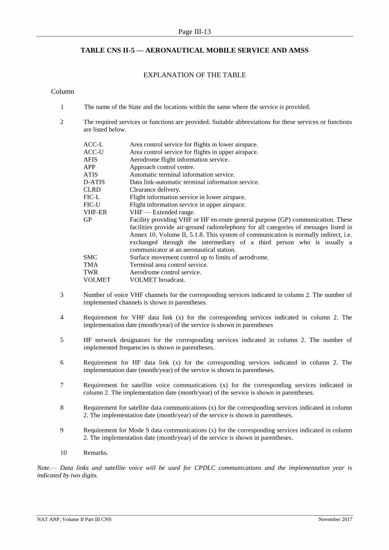
TABLE CNS II-5 — AERONAUTICAL MOBILE SERVICE AND AMSS
EXPLANATION OF THE TABLE
Column
1 The name of the State and the locations within the same where the service is provided.
2 The required services or functions are provided. Suitable abbreviations for these services or functions
are listed below.
ACC-L Area control service for flights in lower airspace.
ACC-U Area control service for flights in upper airspace.
AFIS Aerodrome flight information service.
APP Approach control centre.
ATIS Automatic terminal information service.
D-ATIS Data link-automatic terminal information service.
CLRD Clearance delivery.
FIC-L Flight information service in lower airspace.
FIC-U Flight information service in upper airspace.
VHF-ER VHF — Extended range.
GP Facility providing VHF or HF en-route general purpose (GP) communication. These
facilities provide air-ground radiotelephony for all categories of messages listed in
Annex 10, Volume II, 5.1.8. This system of communication is normally indirect, i.e.
exchanged through the intermediary of a third person who is usually a
communicator at an aeronautical station.
SMC Surface movement control up to limits of aerodrome.
TMA Terminal area control service.
TWR Aerodrome control service.
VOLMET VOLMET broadcast.
3 Number of voice VHF channels for the corresponding services indicated in column 2. The number of
implemented channels is shown in parentheses.
4 Requirement for VHF data link (x) for the corresponding services indicated in column 2. The
implementation date (month/year) of the service is shown in parentheses
5 HF network designators for the corresponding services indicated in column 2. The number of
implemented frequencies is shown in parentheses.
6 Requirement for HF data link (x) for the corresponding services indicated in column 2. The
implementation date (month/year) of the service is shown in parentheses.
7 Requirement for satellite voice communications (x) for the corresponding services indicated in
column 2. The implementation date (month/year) of the service is shown in parentheses.
8 Requirement for satellite data communications (x) for the corresponding services indicated in column
2. The implementation date (month/year) of the service is shown in parentheses.
9 Requirement for Mode S data communications (x) for the corresponding services indicated in column
2. The implementation date (month/year) of the service is shown in parentheses.
10 Remarks.
Note.— Data links and satellite voice will be used for CPDLC communications and the implementation year is
indicated by two digits.
Page III-14
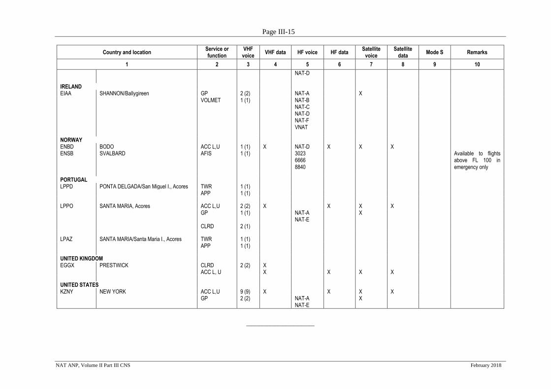
NAT ANP, Volume II Part III CNS February 2018
TABLE CNS II-5— AERONAUTICAL MOBILE SERVICE AND AMSS
Country and location Service or function
VHF voice
VHF data HF voice HF data Satellite
voice Satellite
data Mode S Remarks
1 2 3 4 5 6 7 8 9 10
CANADA CZQX GANDER GP 5 (5) X
(01/2008) NAT-A NAT-B NAT-C NAT-D
X (2009) X (01/2008)
CLRD 5 (5) X (05/2006)
NAT-F
VNAT GREENLAND (Denmark) BGGL NUUK FIC-L 4 (4) RDARA X BGSF KANGERLUSSUAQ TWR 1 (1) APP 2 (2) FAROE ISLANDS (Denmark) EKVG VAGAR AFIS 1 (1) ICELAND BIAR AKUREYRI TWR 1 (1) APP 1 (1) BIEG EGILSSTADIR AFIS 1 (1) BIKF KEFLAVIK TWR 1 (1) GND 1 (1) APP 1 (1) CLRD 1 (1) ATIS 1 (1) BIRK REYKJAVIK TWR 1 (1) GND 1 (1) APP 1 (1) ATIS 1 (1) BIRD REYKJAVIK ACC-U 9 (9) X X X X ACC-L 2 (2)
BICC REYKJAVIK GP 3 (3) NAT-B NAT-C
X
Page III-15
NAT ANP, Volume II Part III CNS February 2018
Country and location Service or function
VHF voice
VHF data HF voice HF data Satellite
voice Satellite
data Mode S Remarks
1 2 3 4 5 6 7 8 9 10
NAT-D IRELAND EIAA SHANNON/Ballygireen GP 2 (2) NAT-A X VOLMET 1 (1) NAT-B
NAT-C NAT-D NAT-F VNAT
NORWAY ENBD BODO ACC L,U 1 (1) X NAT-D X X X ENSB SVALBARD AFIS 1 (1) 3023
6666 8840
Available to flights above FL 100 in emergency only
PORTUGAL LPPD PONTA DELGADA/San Miguel I., Acores TWR 1 (1) APP 1 (1)
LPPO SANTA MARIA, Acores ACC L,U 2 (2) X X X X GP 1 (1) NAT-A
NAT-E X
CLRD 2 (1)
LPAZ SANTA MARIA/Santa Maria I., Acores TWR 1 (1) APP 1 (1)
UNITED KINGDOM EGGX PRESTWICK CLRD 2 (2) X ACC L, U X X X X
UNITED STATES KZNY NEW YORK ACC L,U 9 (9) X X X X GP 2 (2) NAT-A
NAT-E X
__________________________
Page III-16
NAT ANP, Volume II Part III CNS November 2017
TABLE CNS II-6 - ATS DATA CIRCUITS PLAN
EXPLANATION OF THE TABLE
Column
1 and 2 Circuit terminal stations are listed alphabetically by the Terminal I.
3 Type of service specified:
LTF — landline telephone (landline, cable, UHF, VHF, satellite).
RTF — radiotelephone.
4 Type of circuits; Direct (DIR) or Switched (SW).
D — indicates a direct circuit connecting Terminals I and II.
S — indicates that a direct circuit does not exist and that the connection is established via switching at
the switching centre(s) indicated in column 6.
5 Location of switching centre(s). Alternate routing location, if available, is indicated in brackets.
6 Status of Implementation. Following codes are used in this column:
a) I — if the circuit is implemented.
b) No indication or mark if the circuit is not implemented and its implementation date is
unknown.
c) If the circuit is not implemented but its implementation date is available, same is indicated in
brackets.
Note.— If the circuit is implemented but there are short-term plans to establish it in other
private/public network(s), the symbol I/P shall be introduced indicating in Column 8 — Remarks, the
future network environment for the circuit.
7 Remarks
Page III-17
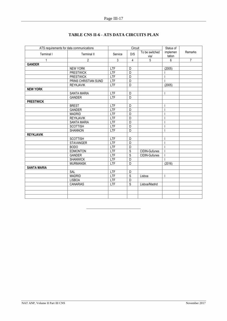
NAT ANP, Volume II Part III CNS November 2017
TABLE CNS II-6 - ATS DATA CIRCUITS PLAN
ATS requirements for data communications Circuit Status of implemen
tation Remarks
Terminal I Terminal II Service D/S To be switched
via/
1 2 3 4 5 6 7
GANDER
NEW YORK LTF D (2005)
PRESTWICK LTF D I
PRESTWICK LTF D I
PRINS CHRISTIAN SUND LTF D I
REYKJAVIK LTF D (2005)
NEW YORK
SANTA MARIA LTF D I
GANDER LTF D
PRESTWICK
BREST LTF D I
GANDER LTF D I
MADRID LTF D I
REYKJAVIK LTF D I
SANTA MARIA LTF D I
SCOTTISH LTF D I
SHANNON LTF D I
REYKJAVIK
SCOTTISH LTF D I
STAVANGER LTF D I
BODO LTF D I
EDMONTON LTF S CIDIN-Gufunes I
GANDER LTF S CIDIN-Gufunes I
SHANWICK LTF D I
MURMANSK LTF D (2016)
SANTA MARIA
SAL LTF D
MADRID LTF S Lisboa I
LISBOA LTF D
CANARIAS LTF S Lisboa/Madrid
Page III-18
NAT ANP, Volume II Part III CNS November 2017
TABLE CNS II-7 — RADIO NAVIGATION AIDS
EXPLANATION OF THE TABLE Column
1 Name of the country, city and aerodrome and, for route aids, the location of the installation.
2 The designator number and runway type:
NINST — Visual flight runway
NPA — Non precision approach runway
PA1 — Precision approach runway, Category I
PA2 — Precision approach runway, Category II
PA3 — Precision approach runway, Category III
3 The functions carried out by the aids appear in columns 4 to 8 and 10 to 12.
A/L — Approach and landing
T — Terminal
E — En route
4 ILS —Instrument landing system. Roman numerals I, II and III indicate the acting category of the ILS I,
II or III. (I) indicates that the facility is implemented.
The letter “D” indicates a DME requirement to serve as a substitute for a marker beacon component of an
ILS.
Note.— Indication of the category refers to the performance standard to be achieved and maintained, in
accordance with pertinent specifications in ICAO Annex 10, and not to specifications of the ILS
equipment, since both specifications are not necessarily the same.
An asterisk (*) indicates that the ILS requires a Category II signal, but without the reliability and
availability which redundant equipment and automatic switching provide.
5 Radio beacon localizer, be it associated with an ILS or to be used as an approach aid at an aerodrome.
6 Radiotelemetrical equipment. When an “X” appears in column 6 in line with the VOR in column 7, this
indicates the need that the DME be installed at a common site with the VOR.
7 VOR — VHF omnidirectional radio range.
8 NDB — Non-directional radio beacon.
9 The distances and altitude to which the VOR or VOR/DME signals are required, indicated in nautical
miles (NM) or thousands of feet, or the nominal coverage recommended of the NDB, indicated in nautical
miles.
10, 11 GNSS — global navigation satellite system (includes GBAS and SBAS).
GBAS (ground-based augmentation system) implementation planned to be used in precision approach
and landing CAT I, CAT II, CAT III.
SBAS (satellite-based augmentation system) implementation planned to be used for route navigation, for
terminal, for non precision approach and landing. An “X” indicates service availability; exact location of
installation will be determined.
Note. — GPS receiver is under standard rules and ABAS (aircraft-based augmentation system).

Page III-19
NAT ANP, Volume II Part III CNS November 2017
12 Remarks
Note.— Columns 5 to 12 use the following symbols:
D — DME required but not implemented.
DI — DME required and implemented.
X — Required but not implemented.
XI — Required and implemented.
Page III-20
NAT ANP, Volume II Part III CNS November 2017
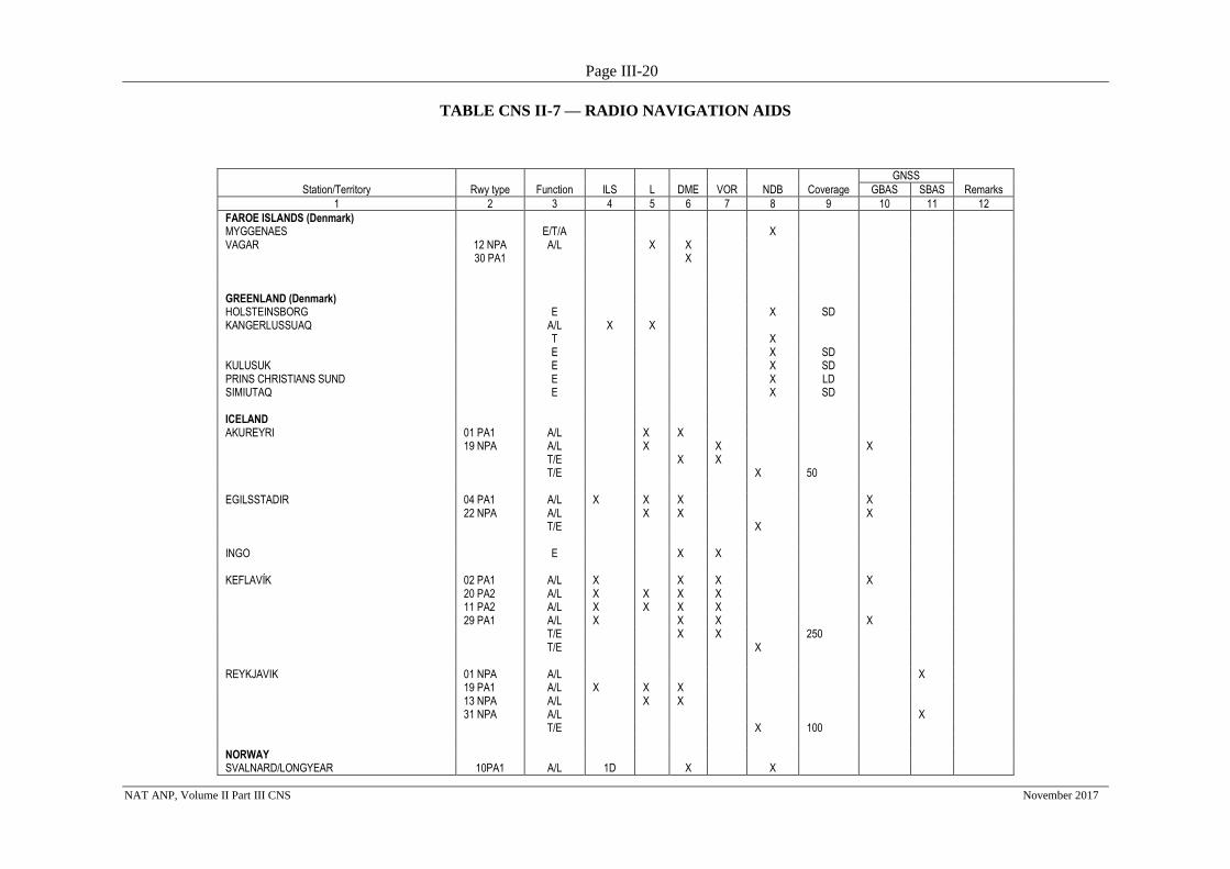
TABLE CNS II-7 — RADIO NAVIGATION AIDS
GNSS
Station/Territory Rwy type Function ILS L DME VOR NDB Coverage GBAS SBAS Remarks
1 2 3 4 5 6 7 8 9 10 11 12
FAROE ISLANDS (Denmark) MYGGENAES E/T/A X VAGAR 12 NPA A/L X X 30 PA1
X
GREENLAND (Denmark) HOLSTEINSBORG E X SD KANGERLUSSUAQ A/L X X T X E X SD KULUSUK E X SD PRINS CHRISTIANS SUND E X LD SIMIUTAQ E X SD ICELAND AKUREYRI 01 PA1 A/L X X 19 NPA A/L X X X T/E X X T/E X 50 EGILSSTADIR 04 PA1 A/L X X X X 22 NPA A/L X X X T/E X INGO E X X KEFLAVÍK 02 PA1 A/L X X X X 20 PA2 A/L X X X X 11 PA2 A/L X X X X 29 PA1 A/L X X X X T/E X X 250 T/E X REYKJAVIK 01 NPA A/L X 19 PA1 A/L X X X 13 NPA A/L X X 31 NPA A/L X T/E X 100 NORWAY SVALNARD/LONGYEAR 10PA1 A/L 1D X X
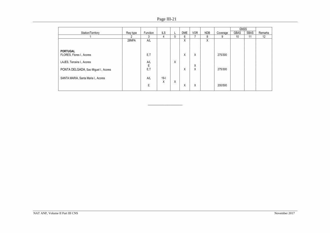
Page III-21
NAT ANP, Volume II Part III CNS November 2017
GNSS
Station/Territory Rwy type Function ILS L DME VOR NDB Coverage GBAS SBAS Remarks
1 2 3 4 5 6 7 8 9 10 11 12
28NPA A/L X X PORTUGAL FLORES, Flores I., Acores E,T X X 275/300 LAJES, Terceira I., Acores A/L X E X
PONTA DELGADA, Sao Miguel I., Acores E,T X X 275/300
SANTA MARIA, Santa Maria I., Acores A/L 19-I X
X
E X X 200/500
________________
Page III-22
NAT ANP, Volume II Part III CNS November 2017
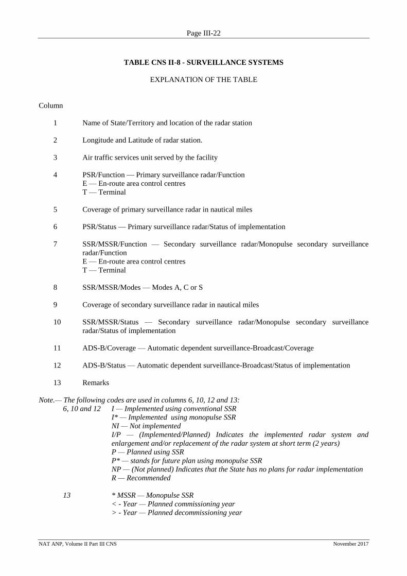
TABLE CNS II-8 - SURVEILLANCE SYSTEMS
EXPLANATION OF THE TABLE
Column
1 Name of State/Territory and location of the radar station
2 Longitude and Latitude of radar station.
3 Air traffic services unit served by the facility
4 PSR/Function — Primary surveillance radar/Function
E — En-route area control centres
T — Terminal
5 Coverage of primary surveillance radar in nautical miles
6 PSR/Status — Primary surveillance radar/Status of implementation
7 SSR/MSSR/Function — Secondary surveillance radar/Monopulse secondary surveillance
radar/Function
E — En-route area control centres
T — Terminal
8 SSR/MSSR/Modes — Modes A, C or S
9 Coverage of secondary surveillance radar in nautical miles
10 SSR/MSSR/Status — Secondary surveillance radar/Monopulse secondary surveillance
radar/Status of implementation
11 ADS-B/Coverage — Automatic dependent surveillance-Broadcast/Coverage
12 ADS-B/Status — Automatic dependent surveillance-Broadcast/Status of implementation
13 Remarks
Note.— The following codes are used in columns 6, 10, 12 and 13:
6, 10 and 12 I — Implemented using conventional SSR
I* — Implemented using monopulse SSR
NI — Not implemented
I/P — (Implemented/Planned) Indicates the implemented radar system and
enlargement and/or replacement of the radar system at short term (2 years)
P — Planned using SSR
P* — stands for future plan using monopulse SSR
NP — (Not planned) Indicates that the State has no plans for radar implementation
R — Recommended
13 * MSSR — Monopulse SSR
< - Year — Planned commissioning year
> - Year — Planned decommissioning year
Page III-23
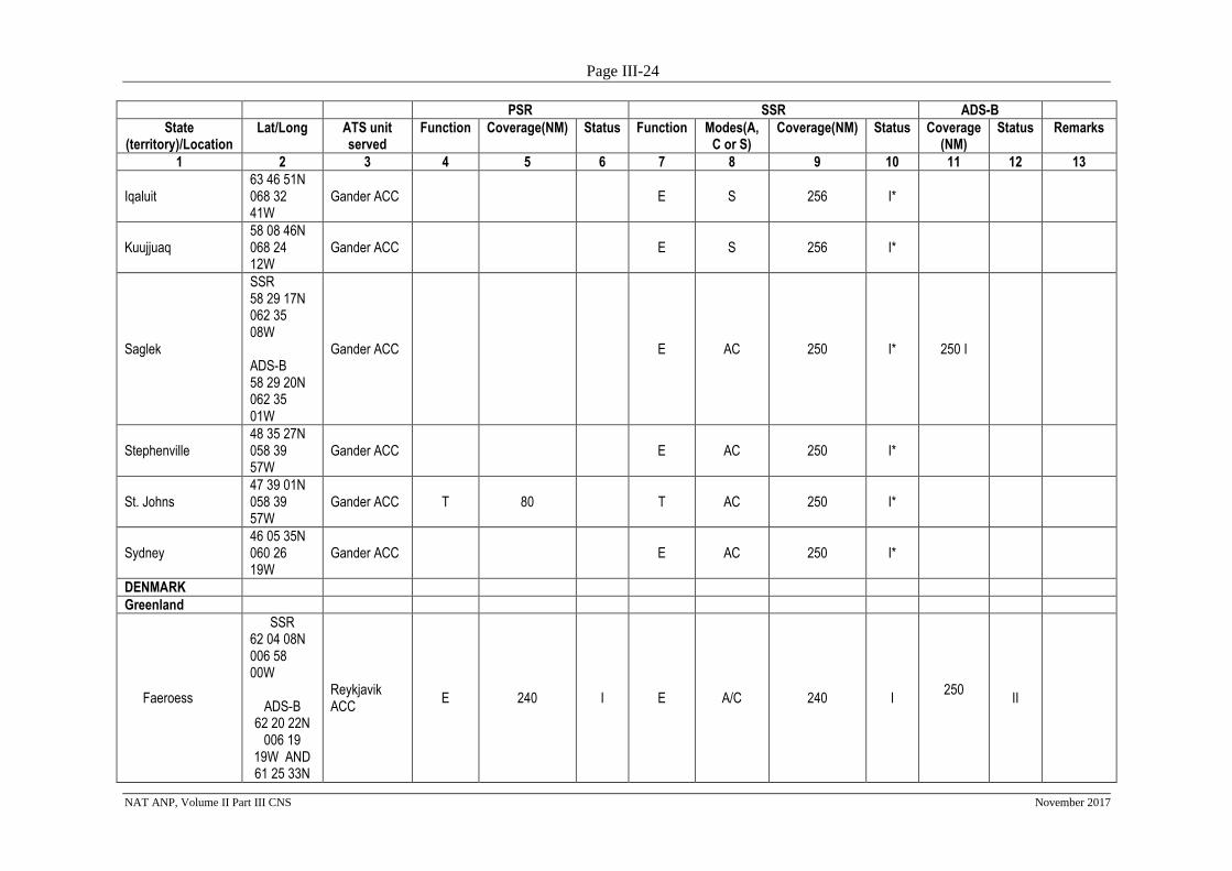
NAT ANP, Volume II Part III CNS November 2017
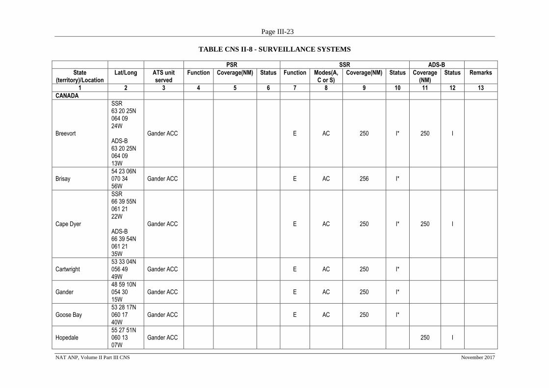
TABLE CNS II-8 - SURVEILLANCE SYSTEMS
PSR SSR ADS-B
State (territory)/Location
Lat/Long ATS unit served
Function Coverage(NM) Status Function Modes(A, C or S)
Coverage(NM) Status Coverage (NM)
Status Remarks
1 2 3 4 5 6 7 8 9 10 11 12 13
CANADA
Breevort
SSR 63 20 25N 064 09 24W ADS-B 63 20 25N 064 09 13W
Gander ACC E AC 250 I* 250 I
Brisay 54 23 06N 070 34 56W
Gander ACC E AC 256 I*
Cape Dyer
SSR 66 39 55N 061 21 22W ADS-B 66 39 54N 061 21 35W
Gander ACC E AC 250 I* 250 I
Cartwright 53 33 04N 056 49 49W
Gander ACC E AC 250 I*
Gander 48 59 10N 054 30 15W
Gander ACC E AC 250 I*
Goose Bay 53 28 17N 060 17 40W
Gander ACC E AC 250 I*
Hopedale 55 27 51N 060 13 07W
Gander ACC 250 I
Page III-24
NAT ANP, Volume II Part III CNS November 2017
PSR SSR ADS-B
State (territory)/Location
Lat/Long ATS unit served
Function Coverage(NM) Status Function Modes(A, C or S)
Coverage(NM) Status Coverage (NM)
Status Remarks
1 2 3 4 5 6 7 8 9 10 11 12 13
Iqaluit 63 46 51N 068 32 41W
Gander ACC E S 256 I*
Kuujjuaq 58 08 46N 068 24 12W
Gander ACC E S 256 I*
Saglek
SSR 58 29 17N 062 35 08W ADS-B 58 29 20N 062 35 01W
Gander ACC E AC 250 I* 250 I
Stephenville 48 35 27N 058 39 57W
Gander ACC E AC 250 I*
St. Johns 47 39 01N 058 39 57W
Gander ACC T 80 T AC 250 I*
Sydney 46 05 35N 060 26 19W
Gander ACC E AC 250 I*
DENMARK
Greenland
Faeroess
SSR 62 04 08N 006 58 00W
ADS-B 62 20 22N
006 19 19W AND 61 25 33N
Reykjavik ACC
E 240 I E A/C 240 I
250 II
Page III-25
NAT ANP, Volume II Part III CNS November 2017
PSR SSR ADS-B
State (territory)/Location
Lat/Long ATS unit served
Function Coverage(NM) Status Function Modes(A, C or S)
Coverage(NM) Status Coverage (NM)
Status Remarks
1 2 3 4 5 6 7 8 9 10 11 12 13
006 44 16W
Frederiksdal
60 00 01N 044 36 36W
Gander ACC
250 I Installed and
maintained by Canada
Kangerlussuac 66 59 49N 050 36 58W
BGSF T/A T A,C 200 I
Paamuit
61 59 33N 049 40 28W
Gander ACC
250 I Installed and
maintained by Canada
Prins Christian Sun
60 02 59N 043 09 30W
Gander ACC
250 I Installed and
maintained by Canada
Simiutaq
60 40 59N 046 35 48W
Gander ACC
250 I Installed and
maintained by Canada
ICELAND
Akureyri 65 39 18N 018 04 09W
Akureyri APP T 20 I
Blafjoll 63 58 37N 021 38 04W
Reykjavik ACC E 250 I
Bolafjall 66 10 42N 023 19 42W
Reykjavik ACC
E 240 I E A/C 240 I 250 I MSSR 06
Gunnolfsvikurfjall 66 08 40N 015 05 24W
Reykjavik ACC
E 240 I E A/C 240 I 250 I MSSR 06
Háfell 63 26 35N 018 51
Reykjavik ACC
E 250 I
Page III-26
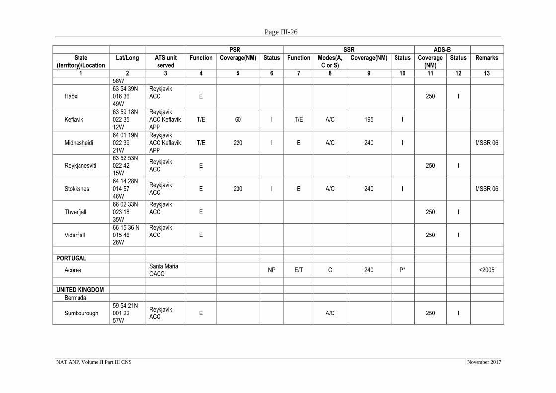
NAT ANP, Volume II Part III CNS November 2017
PSR SSR ADS-B
State (territory)/Location
Lat/Long ATS unit served
Function Coverage(NM) Status Function Modes(A, C or S)
Coverage(NM) Status Coverage (NM)
Status Remarks
1 2 3 4 5 6 7 8 9 10 11 12 13
58W
Háöxl 63 54 39N 016 36 49W
Reykjavik ACC E 250 I
Keflavik 63 59 18N 022 35 12W
Reykjavik ACC Keflavik APP
T/E 60 I T/E A/C 195 I
Midnesheidi 64 01 19N 022 39 21W
Reykjavik ACC Keflavik APP
T/E 220 I E A/C 240 I MSSR 06
Reykjanesviti 63 52 53N 022 42 15W
Reykjavik ACC
E 250 I
Stokksnes 64 14 28N 014 57 46W
Reykjavik ACC
E 230 I E A/C 240 I MSSR 06
Thverfjall 66 02 33N 023 18 35W
Reykjavik ACC E 250 I
Vidarfjall 66 15 36 N 015 46 26W
Reykjavik ACC E 250 I
PORTUGAL
Acores Santa Maria
OACC NP E/T C 240 P* <2005
UNITED KINGDOM
Bermuda
Sumbourough 59 54 21N 001 22 57W
Reykjavik ACC
E A/C 250 I
Page IV-1
NAT ANP, Volume II Part IV (ATM) November 2017
NAT ANP, VOLUME II
PART IV - AIR TRAFFIC MANAGEMENT (ATM)
1. INTRODUCTION
1.1 This part of the NAT ANP, Volume II, complements the provisions in ICAO SARPs and
PANS related to air traffic management (ATM). It contains dynamic plan elements related to the assignment
of responsibilities to States for the provision of ATM facilities and services within a specified area in
accordance with Article 28 of the Convention on International Civil Aviation (Doc 7300); and mandatory
requirements related to ATM facilities and services to be implemented by States in accordance with regional
air navigation agreements. Such agreement indicates a commitment on the part of the State(s) concerned to
implement the requirement(s) specified.
2. GENERAL REGIONAL REQUIREMENTS
Optimization of traffic flows
2.1 The Planning and Implementation Regional Groups (PIRGs), through regional air navigation
agreement, are responsible for the optimization of the traffic flows through the continuous improvement of
the regional ATS route network and organized track systems and implementation of random routing areas
and free route airspace in the Region through the set-up of appropriate mechanisms for regional and inter-
regional planning and coordination.
2.2 Whenever practicable, States should, in close coordination with operators, establish the most
efficient routings.
2.3 The requirements for regional ATS route network, in particular, for ATS routes over the high
seas and airspace of undetermined sovereignty, should be agreed upon through regional air navigation
agreement.
Note: States’ AIPs and other States publications should be consulted for information on the
implemented ATS routes.
Aircraft Identification-SSR Code Management
Note: Not applicable in the NATRegion
3. SPECIFIC REGIONAL REQUIREMENTS
3.1 ATS routes have been developed in the NAT Region for the use of aircraft equipped with
only one long-range navigation system, and of aircraft equipped with short-range navigation equipment
(VOR/DME, ADF). These routes are listed in NAT Doc 007.
3.2 Twice daily, organized track systems (OTS) are promulgated to manage the core East-West
flows of traffic in the NAT Region. Details are provided in NAT SUPPs, 6.4 and NAT Doc 007.
Page IV-2
NAT ANP, Volume II Part IV (ATM) November 2017
Regional safety monitoring
3.3 The NAT Central Monitoring Agency (CMA) is responsible for the monitoring and reporting
of certain aspects of operations in the NAT Region. The NAT CMA was initially established in 1985 by the
ICAO North Atlantic System Planning Group (NATSPG) to support the preparation and introduction of
RVSM in the North Atlantic (NAT) Region, and thereafter to perform a database assessment and provide
assurance of continuing system safety and integrity.
3.4 The CMA is one of thirteen Regional Monitoring Agencies (RMAs) around the world which
serves its ICAO Planning and Implementation Regional Groups, its associated States, ANSPs and aircraft
operators. Currently, the NAT CMA maintains State Registration and Operational Approval records for
aircraft registered in five designated States (Norway, Iceland, Ireland, Portugal and Bermuda) and
Operational Approvals granted by other States for aircraft registered in these five States; it also assists those
States in overseeing operator compliance with height monitoring targets in accordance with ICAO Annex 6
(Operation of Aircraft) requirements. It supports the RMA community by maintaining a combined database
of aircraft registration, operators and RVSM Approvals, incorporating regular revisions of data from other
RMAs into a common system.
3.5 To monitor compliance with the RVSM Minimum Navigation Performance Specification
(RVSM MASPS) the CMA processes and reviews aircraft height keeping performance to determine
altimetry system error (ASE) and issues height monitoring results to operators. To do this the CMA uses
recorded data from the Height Monitoring Unit (HMU) at Strumble (Wales) on the basis of individual
operator requests but also utilises the data continuously recorded of aircraft passing the HMU site within
RVSM levels.
3.6 The CMA also receives, reviews and records operational safety occurrence reports from
ANSPs and aircraft operators across the North Atlantic Region, in support of regional safety groups and
other stakeholders. The resultant records provide data to support regional risk assessment (technical and
operational risk), analysis and the measurement of performance against established Target Levels of Safety
and trend data, to support the work of the ICAO safety groups. This data also supports the safe evolution of
separation standards, navigational requirements and procedures.
3.7 The CMA has a small permanent staff augmented by specialists across a range of disciplines
and skills. Since 1985 the scope of the CMA has included flight operations (pilot/navigator) and analytical,
mathematical, technical, and engineering skills provided by NATS Ltd, the UK Air Navigation Service
Provider (ANSP). The operating costs of the CMA and the maintenance of the Height Monitoring Unit are
recovered from ICAO under a Joint Financing Arrangement signed in 1995 by the governments of several
NATSPG Member States: Canada, Iceland, Ireland, Portugal the United Kingdom, United States and ICAO.
3.8 The CMA is located adjacent to the Shanwick Oceanic Area Control Centre, in Prestwick,
Scotland in accommodation provided by NATS on behalf of the United Kingdom. While functionally
autonomous from its host State the CMA can access specialist support and ATC expertise.
Monitoring
3.9 Operators engaged in North Atlantic operations and States having jurisdiction over such
operators should investigate carefully any known or reported case of gross navigation error which has
occurred during a flight in the NAT Region of an aircraft with which they are concerned and, where found
appropriate, States concerned and operators should take the necessary corrective actions.
3.10 States should investigate navigation errors which are brought to the attention of operators
and/or where necessary the State of Registry of the aircraft concerned with the least possible delay.
____________________
Page IV-3
NAT ANP, Volume II Part IV (ATM) November 2017
TABLE ATM II-1 - NAT REGION ATS ROUTES
EXPLANATION OF THE TABLE
Column
1 Designator of ATS route
2 Significant points defining the ATS route. Only prominent locations have been listed.
3 Purpose/Usage of Routes
Designator Significant Points Purpose/Usage/Restrictions
1 2 3
TANGO Routes
T9 LASNO - BEGAS For flights between Northern
Europe and Spain/
Canarias/Lisboa FIRs.
T13 MANOX – LUPOV (420000N
01505000W) – NILAV (450000N
01325000W) – OMOKO
For flights between Northern
Europe and Canarias/Lisboa FIRs.
T213
TAMEL - BERUX For flights between Northern
Europe and Spain/
Canarias/Lisboa FIRs.
T16
OMOKO – GONAN – EKROL
(420000N 01535000W) – NAVIX
– SNT
For flights between Northern
Europe and Canarias/Lisboa FIRs.
T25 GUNTI – LENSI (390000N
0200000W)
For flights between the Azores
and the Portuguese mainland.
Routings between the Azores and
Portugal and between the Azores
and Madeira
TBA Special Routes for Flights
between the Azores and the
Portuguese mainland and between
the Azores and the Madeira
Archipelago
Special Use Routings Details listed in Provider State
AIS and in ICAO NAT Doc.007
NAT Operations & Airspace
Manual
For use by aircraft with a single
functioning LRNS or with short
range navigation systems. State
Approvals for NAT HLA
operations are still required.
L576 BDA/VOR 322152N 0644123W
SEAVR 294156N 0630425W
RKDIA 210000N 0600000W
(CITRS 180000N 0590000W)
For flights southbound from the
Bermuda VOR (BDA) between
north-eastern United States to Rio
de Janeiro (Brazil), Sao Paulo
(Brazil) and Buenos Aires
(Argentina).
____________________
Page V-1
NAT ANP, Volume II Part V (MET) March 2018
NAT ANP, VOLUME II
PART V – METEOROLOGY (MET)
1. INTRODUCTION
1.1 This part of the NAT ANP, Volume II, complements the provisions in the ICAO SARPs and
PANS related to aeronautical meteorology (MET). It contains dynamic plan elements related to the
assignment of responsibilities to States for the provision of MET facilities and services within a specified
area in accordance with Article 28 of the Convention on International Civil Aviation (Doc 7300); and
mandatory requirements related to the MET facilities and services to be implemented by States in accordance
with regional air navigation agreements. Such agreement indicates a commitment on the part of the States
concerned to implement the requirements specified.
2. GENERAL REGIONAL REQUIREMENTS
Meteorological offices
2.1 In the NAT Region, meteorological watch offices (MWO) have been designated to maintain
continuous watch on meteorological conditions affecting flight operations within their area(s) of
responsibility, as indicated at Table MET II-1.
Meteorological observations and reports
2.2 In the NAT Region, routine observations, issued as a METAR, should be made throughout
the 24 hours of each day at intervals of one half-hour or one hour at aerodromes as indicated in Table MET
II-2.
2.3 At aerodromes that are not operational throughout 24 hours, METAR should be issued at
least 3 hours prior to the aerodrome resuming operations or as agreed upon between airspace users and the
MET Authority in the NAT Region.
Forecasts
2.4 In the NAT Region, an aerodrome forecast, issued as a TAF, should be for the aerodromes
indicated in Table MET II-2.
2.5 In the NAT Region, the period of validity of a routine TAF should be of 9-, 24-, or 30-hours
to meet the requirements indicated in Table MET II-2.
2.6 In the NAT Region, the forecast maximum and minimum temperatures expected to occur
during the period of validity, together with their corresponding day and time of occurrence, should be
included in TAF at aerodromes indicated in Table MET II-2.
2.7 In the NAT Region, landing forecasts (prepared in the form of a trend forecast) should be
provided at aerodromes indicated in Table MET II-2.
Page V-2
NAT ANP, Volume II Part V (MET) March 2018
Requirements for and use of communications
2.8 Operational meteorological information prepared as METAR, SPECI and TAF for
aerodromes indicated in Table MET II-2, and SIGMET messages prepared for flight information regions or
control areas indicated in Table MET II-1, should be disseminated to the international OPMET databanks
designated for the NAT Region (namely Brussels OPMET databank) and to the centre designated for the
operation of the aeronautical fixed service satellite distribution system (SADIS) and the Internet-based
service (Secure SADIS FTP) and/or WIFS in the NAT Region.
2.9 SIGMET messages should be disseminated to other meteorological offices in the NAT
Region in accordance with the regional OPMET bulletin exchange scheme.
2.10 Special air-reports that do not warrant the issuance of a SIGMET should be disseminated to
other meteorological offices in the NAT Region in accordance with the regional OPMET bulletin exchange
scheme.
2.11 In the NAT Region, meteorological information for use by aircraft in flight should be
supplied through VOLMET broadcasts.
2.12 In the NAT Region, the aerodromes for which METAR and SPECI are to be included in
VOLMET broadcasts, the sequence in which they are to be transmitted and the broadcast time, is indicated in
Table MET II-3.
3. SPECIFIC REGIONAL REQUIREMENTS
Meteorological observations and reports
3.1 In the NAT Region, information on the status of the runway should be included as
supplementary information in METAR and SPECI as indicated in Table MET II-2.
3.2 The observations required under the current Danish and Icelandic Joint Financing
Agreements are given in Table MET II-4.
OPMET information
3.3 The details of the NAT regional OPMET bulletin exchange scheme are provided in the EUR
OPMET Data Management Handbook (EUR Doc 018).
Note: The EUR Data Management Group (DMG) of the European Air Navigation Planning
Group (EANPG) Meteorological Group (METG) updates this document accordingly for approval by the
EANPG Programme Coordinating Group (COG). Denmark, Iceland and the United States participate in the
work of the METG. The Regional OPMET Centre (ROC) London coordinates exchange of date with Canada.
Service for operators and flight crew members
3.4 In the NAT Region, scheduled VOLMET broadcasts should contain TAF and SIGMET.
3.56 In the NAT Region, METAR, SPECI and TAF should be available for uplink to aircraft in
flight via D-VOLMET.
______________________
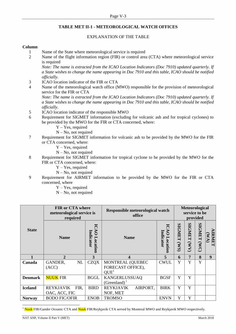
Page V-3
NAT ANP, Volume II Part V (MET) March 2018
TABLE MET II-1 - METEOROLOGICAL WATCH OFFICES
EXPLANATION OF THE TABLE
Column
1 Name of the State where meteorological service is required
2 Name of the flight information region (FIR) or control area (CTA) where meteorological service
is required
Note: The name is extracted from the ICAO Location Indicators (Doc 7910) updated quarterly. If
a State wishes to change the name appearing in Doc 7910 and this table, ICAO should be notified
officially.
3 ICAO location indicator of the FIR or CTA
4 Name of the meteorological watch office (MWO) responsible for the provision of meteorological
service for the FIR or CTA
Note: The name is extracted from the ICAO Location Indicators (Doc 7910) updated quarterly. If
a State wishes to change the name appearing in Doc 7910 and this table, ICAO should be notified
officially.
5 ICAO location indicator of the responsible MWO
6 Requirement for SIGMET information (excluding for volcanic ash and for tropical cyclones) to
be provided by the MWO for the FIR or CTA concerned, where:
Y – Yes, required
N – No, not required
7 Requirement for SIGMET information for volcanic ash to be provided by the MWO for the FIR
or CTA concerned, where:
Y – Yes, required
N – No, not required
8 Requirement for SIGMET information for tropical cyclone to be provided by the MWO for the
FIR or CTA concerned, where:
Y – Yes, required
N – No, not required
9 Requirement for AIRMET information to be provided by the MWO for the FIR or CTA
concerned, where
Y – Yes, required
N – No, not required
State
FIR or CTA where
meteorological service is
required
Responsible meteorological watch
office
Meteorological
service to be
provided
Name
ICA
O L
oca
tion
Ind
icato
r
Name
ICA
O L
oca
tion
Ind
icato
r
SIG
ME
T (W
S)
SIG
ME
T (W
V)
SIG
ME
T (W
C)
AIR
ME
T
(WA
)
1 2 3 4 5 6 7 8 9
Canada GANDER, NL
(ACC)
CZQX MONTREAL (QUEBEC
FORECAST OFFICE),
QUE1
CWUL Y Y Y
Denmark NUUK FIR BGGL KANGERLUSSUAQ
(Greenland) 1
BGSF Y Y
Iceland REYKJAVIK FIR,
OAC, ACC, FIC
BIRD REYKJAVIK AIRPORT,
NOF, MET
BIRK Y Y
Norway BODO FIC/OFIR ENOB TROMSO ENVN Y Y
1 Nuuk FIR/Gander Oceanic CTA and Nuuk FIR/Reykjavik CTA served by Montreal MWO and Reykjavik MWO respectively.
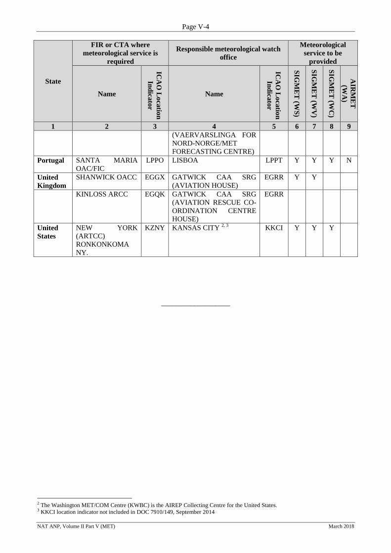
Page V-4
NAT ANP, Volume II Part V (MET) March 2018
State
FIR or CTA where
meteorological service is
required
Responsible meteorological watch
office
Meteorological
service to be
provided
Name
ICA
O L
oca
tion
Ind
icato
r
Name
ICA
O L
oca
tion
Ind
icato
r
SIG
ME
T (W
S)
SIG
ME
T (W
V)
SIG
ME
T (W
C)
AIR
ME
T
(WA
)
1 2 3 4 5 6 7 8 9
(VAERVARSLINGA FOR
NORD-NORGE/MET
FORECASTING CENTRE)
Portugal SANTA MARIA
OAC/FIC
LPPO LISBOA LPPT Y Y Y N
United
Kingdom
SHANWICK OACC EGGX GATWICK CAA SRG
(AVIATION HOUSE)
EGRR Y Y
KINLOSS ARCC EGQK GATWICK CAA SRG
(AVIATION RESCUE CO-
ORDINATION CENTRE
HOUSE)
EGRR
United
States
NEW YORK
(ARTCC)
RONKONKOMA
NY.
KZNY KANSAS CITY 2, 3
KKCI Y Y Y
___________________
2 The Washington MET/COM Centre (KWBC) is the AIREP Collecting Centre for the United States. 3 KKCI location indicator not included in DOC 7910/149, September 2014
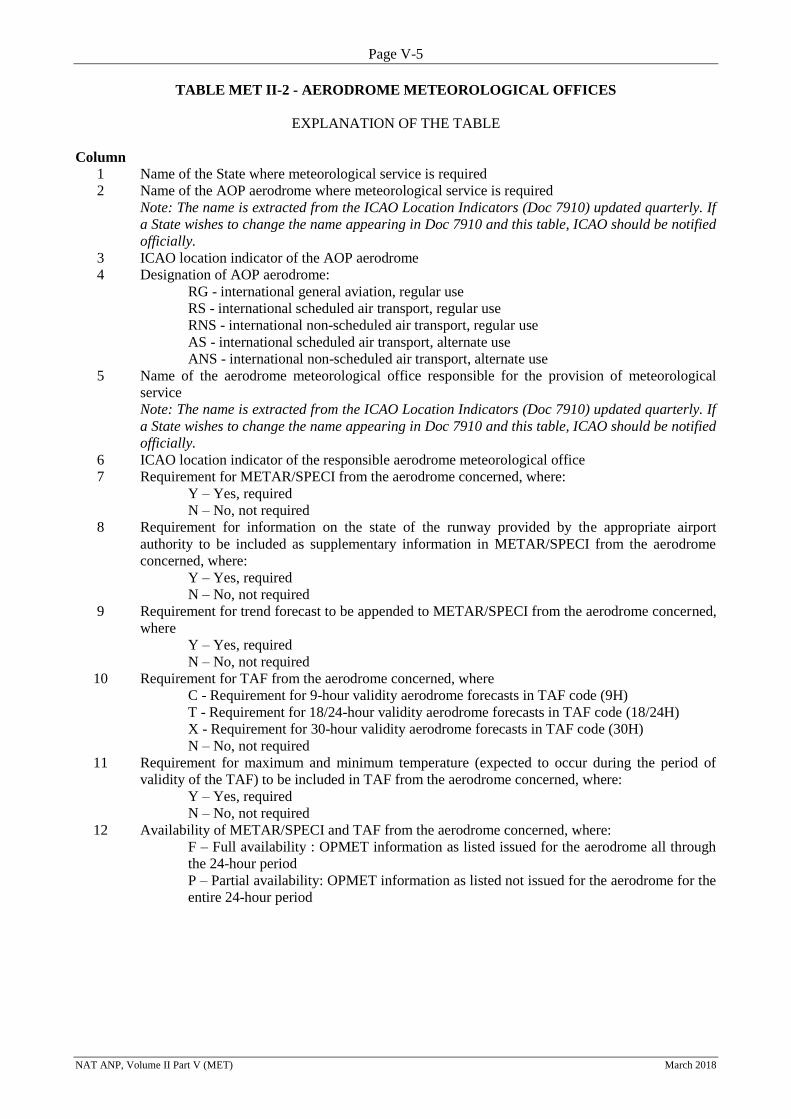
Page V-5
NAT ANP, Volume II Part V (MET) March 2018
TABLE MET II-2 - AERODROME METEOROLOGICAL OFFICES
EXPLANATION OF THE TABLE
Column
1 Name of the State where meteorological service is required
2 Name of the AOP aerodrome where meteorological service is required
Note: The name is extracted from the ICAO Location Indicators (Doc 7910) updated quarterly. If
a State wishes to change the name appearing in Doc 7910 and this table, ICAO should be notified
officially.
3 ICAO location indicator of the AOP aerodrome
4 Designation of AOP aerodrome:
RG - international general aviation, regular use
RS - international scheduled air transport, regular use
RNS - international non-scheduled air transport, regular use
AS - international scheduled air transport, alternate use
ANS - international non-scheduled air transport, alternate use
5 Name of the aerodrome meteorological office responsible for the provision of meteorological
service
Note: The name is extracted from the ICAO Location Indicators (Doc 7910) updated quarterly. If
a State wishes to change the name appearing in Doc 7910 and this table, ICAO should be notified
officially.
6 ICAO location indicator of the responsible aerodrome meteorological office
7 Requirement for METAR/SPECI from the aerodrome concerned, where:
Y – Yes, required
N – No, not required
8 Requirement for information on the state of the runway provided by the appropriate airport
authority to be included as supplementary information in METAR/SPECI from the aerodrome
concerned, where:
Y – Yes, required
N – No, not required
9 Requirement for trend forecast to be appended to METAR/SPECI from the aerodrome concerned,
where
Y – Yes, required
N – No, not required
10 Requirement for TAF from the aerodrome concerned, where
C - Requirement for 9-hour validity aerodrome forecasts in TAF code (9H)
T - Requirement for 18/24-hour validity aerodrome forecasts in TAF code (18/24H)
X - Requirement for 30-hour validity aerodrome forecasts in TAF code (30H)
N – No, not required
11 Requirement for maximum and minimum temperature (expected to occur during the period of
validity of the TAF) to be included in TAF from the aerodrome concerned, where:
Y – Yes, required
N – No, not required
12 Availability of METAR/SPECI and TAF from the aerodrome concerned, where:
F – Full availability : OPMET information as listed issued for the aerodrome all through
the 24-hour period
P – Partial availability: OPMET information as listed not issued for the aerodrome for the
entire 24-hour period
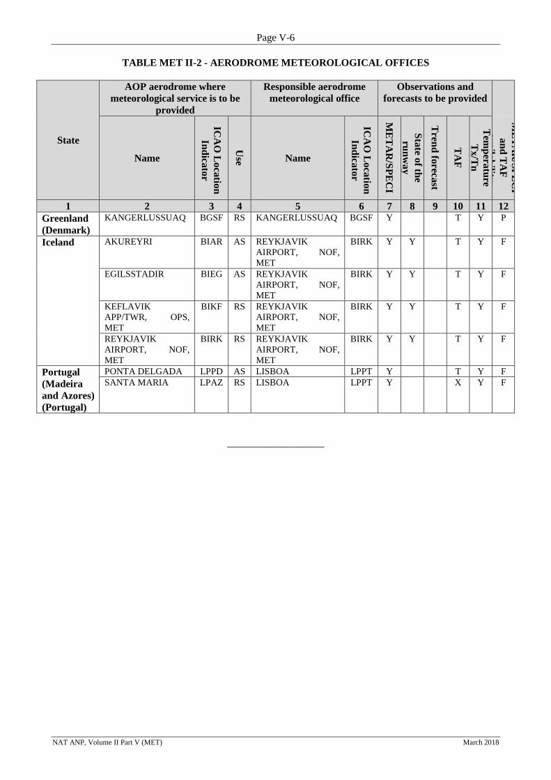
Page V-6
NAT ANP, Volume II Part V (MET) March 2018
TABLE MET II-2 - AERODROME METEOROLOGICAL OFFICES
State
AOP aerodrome where
meteorological service is to be
provided
Responsible aerodrome
meteorological office
Observations and
forecasts to be provided
Name
ICA
O L
oca
tion
Ind
icato
r
Use
Name
ICA
O L
oca
tion
Ind
icato
r
ME
TA
R/S
PE
CI
Sta
te of th
e
run
wa
y
Tren
d fo
recast
TA
F
Tem
pera
ture
Tx
/Tn
ME
TA
R/S
PE
CI
an
d T
AF
av
aila
bility
1 2 3 4 5 6 7 8 9 10 11 12
Greenland
(Denmark)
KANGERLUSSUAQ BGSF RS KANGERLUSSUAQ BGSF Y T Y P
Iceland AKUREYRI BIAR AS REYKJAVIK
AIRPORT, NOF,
MET
BIRK Y Y T Y F
EGILSSTADIR BIEG AS REYKJAVIK
AIRPORT, NOF,
MET
BIRK Y Y T Y F
KEFLAVIK
APP/TWR, OPS,
MET
BIKF RS REYKJAVIK
AIRPORT, NOF,
MET
BIRK Y Y T Y F
REYKJAVIK
AIRPORT, NOF,
MET
BIRK RS REYKJAVIK
AIRPORT, NOF,
MET
BIRK Y Y T Y F
Portugal
(Madeira
and Azores)
(Portugal)
PONTA DELGADA LPPD AS LISBOA LPPT Y T Y F
SANTA MARIA LPAZ RS LISBOA LPPT Y X Y F
___________________
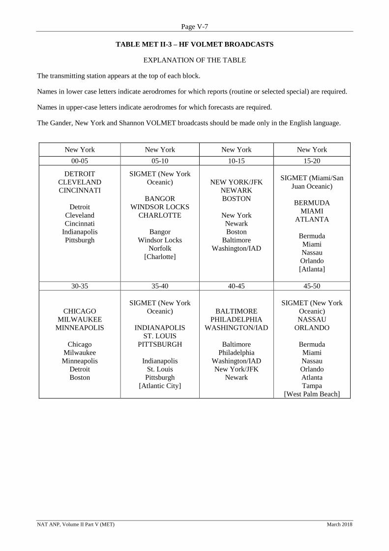
Page V-7
NAT ANP, Volume II Part V (MET) March 2018
TABLE MET II-3 – HF VOLMET BROADCASTS
EXPLANATION OF THE TABLE
The transmitting station appears at the top of each block. Names in lower case letters indicate aerodromes for which reports (routine or selected special) are required. Names in upper-case letters indicate aerodromes for which forecasts are required. The Gander, New York and Shannon VOLMET broadcasts should be made only in the English language.
New York New York New York New York
00-05 05-10 10-15 15-20
DETROIT
CLEVELAND
CINCINNATI
Detroit
Cleveland
Cincinnati
Indianapolis
Pittsburgh
SIGMET (New York
Oceanic)
BANGOR
WINDSOR LOCKS
CHARLOTTE
Bangor
Windsor Locks
Norfolk
[Charlotte]
NEW YORK/JFK
NEWARK
BOSTON
New York
Newark
Boston
Baltimore
Washington/IAD
SIGMET (Miami/San
Juan Oceanic)
BERMUDA
MIAMI
ATLANTA
Bermuda
Miami
Nassau
Orlando
[Atlanta]
30-35 35-40 40-45 45-50
CHICAGO
MILWAUKEE
MINNEAPOLIS
Chicago
Milwaukee
Minneapolis
Detroit
Boston
SIGMET (New York
Oceanic)
INDIANAPOLIS
ST. LOUIS
PITTSBURGH
Indianapolis
St. Louis
Pittsburgh
[Atlantic City]
BALTIMORE
PHILADELPHIA
WASHINGTON/IAD
Baltimore
Philadelphia
Washington/IAD
New York/JFK
Newark
SIGMET (New York
Oceanic)
NASSAU
ORLANDO
Bermuda
Miami
Nassau
Orlando
Atlanta
Tampa
[West Palm Beach]
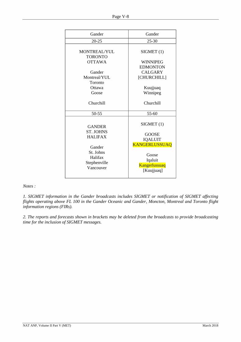
Page V-8
NAT ANP, Volume II Part V (MET) March 2018
Gander Gander
20-25 25-30
MONTREAL/YUL
TORONTO
OTTAWA
Gander
Montreal/YUL
Toronto
Ottawa
Goose
Churchill
SIGMET (1)
WINNIPEG
EDMONTON
CALGARY
[CHURCHILL]
Kuujjuaq
Winnipeg
Churchill
50-55 55-60
GANDER
ST. JOHNS
HALIFAX
Gander
St. Johns
Halifax
Stephenville
Vancouver
SIGMET (1)
GOOSE
IQALUIT
KANGERLUSSUAQ
Goose
Iqaluit
Kangerlussuaq
[Kuujjuaq]
Notes :
1. SIGMET information in the Gander broadcasts includes SIGMET or notification of SIGMET affecting
flights operating above FL 100 in the Gander Oceanic and Gander, Moncton, Montreal and Toronto flight
information regions (FIRs).
2. The reports and forecasts shown in brackets may be deleted from the broadcasts to provide broadcasting
time for the inclusion of SIGMET messages.
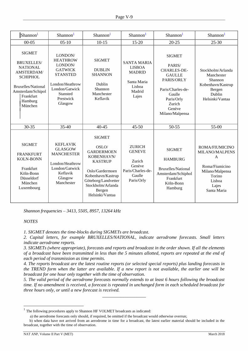
Page V-9
NAT ANP, Volume II Part V (MET) March 2018
Shannon1 Shannon
1 Shannon
1 Shannon
1 Shannon
1 Shannon
1
00-05 05-10 10-15 15-20 20-25 25-30
SIGMET
BRUXELLES/
NATIONAL
AMSTERDAM/
SCHIPHOL
Bruxelles/National
Amsterdam/Schipol
Frankfurt
Hamburg
München
LONDON/
HEATHROW
LONDON/
GATWICK
STANSTED
London/Heathrow
London/Gatwick
Stansted
Prestwick
Glasgow
SIGMET
DUBLIN
SHANNON
Dublin
Shannon
Manchester
Keflavik
SANTA MARIA
LISBOA
MADRID
Santa Maria
Lisboa
Madrid
Lajes
SIGMET
PARIS/
CHARLES-DE-
GAULLE
PARIS/ORLY
Paris/Charles-de-
Gaulle
Paris/Orly
Zurich
Genève
Milano/Malpensa
Stockholm/Arlanda
Manchester
Shannon
Kobenhavn/Kastrup
Bergen
Dublin
Helsinki/Vantaa
30-35 35-40 40-45 45-50 50-55 55-00
SIGMET
FRANKFURT
KOLN-BONN
Frankfurt
Köln-Bonn
Düsseldorf
München
Luxembourg
KEFLAVIK
GLASGOW
MANCHESTER
London/Heathrow
London/Gatwick
Keflavik
Glasgow
Manchester
SIGMET
OSLO/
GARDERMOEN
KOBENHAVN/
KASTRUP
Oslo/Gardermoen
Kobenhavn/Kastrup
Göteborg/Landvetter
Stockholm/Arlanda
Bergen
Helsinki/Vantaa
ZURICH
GENEVE
Zurich
Genève
Paris/Charles-de-
Gaulle
Paris/Orly
SIGMET
HAMBURG
Bruxelles/National
Amsterdam/Schiphol
Frankfurt
Köln-Bonn
Hamburg
ROMA/FIUMICINO
MILANO/MALPENS
A
Roma/Fiumicino
Milano/Malpensa
Torino
Lisboa
Lajes
Santa Maria
Shannon frequencies – 3413, 5505, 8957, 13264 kHz
NOTES
1. SIGMET denotes the time-blocks during SIGMETs are broadcast.
2. Capital letters, for example BRUXELLES/NATIONAL, indicate aerodrome forecasts. Small letters
indicate aerodrome reports.
3. SIGMETs (where appropriate), forecasts and reports and broadcast in the order shown. If all the elements
of a broadcast have been transmitted in less than the 5 minutes allotted, reports are repeated at the end of
each period of transmission as time permits.
4. The reports broadcast are the latest routine reports (or selected special reports) plus landing forecasts in
the TREND form when the latter are available. If a new report is not available, the earlier one will be
broadcast for one hour only together with the time of observation.
5. The valid period of the aerodrome forecasts normally extends to at least 6 hours following the broadcast
time. If no amendment is received, a forecast is repeated in unchanged form in each scheduled broadcast for
three hours only, or until a new forecast is received.
___________________
1 The following procedures apply to Shannon HF VOLMET broadcasts as indicated:
a) the aerodrome forecasts only should, if required, be omitted if the broadcast would otherwise overrun;
b) when data have not arrived from an aerodrome in time for a broadcast, the latest earlier material should be included in the
broadcast, together with the time of observation.
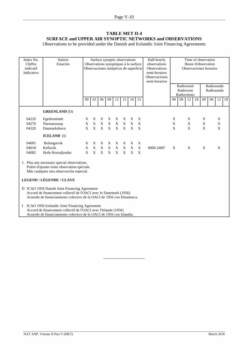
Page V-10
NAT ANP, Volume II Part V (MET) March 2018
TABLE MET II-4
SURFACE and UPPER AIR SYNOPTIC NETWORKS and OBSERVATIONS
Observations to be provided under the Danish and Icelandic Joint Financing Agreements
Index No.
Chiffre
indicatif
Indicativo
Station
Estación
Surface synoptic observations
Observations synoptiques à la surface
Observaciones sinópticos de superficie
Half-hourly
observations
Observations
semi-horaires
Observaciones
semi-horarios
Time of observation
Heure d'observation
Observaciones horarios
Radiowind
Radiovent
Radioviento
Radiosonde
Radiosonda
00 03 06 09 12 15 18 21 00 06 12 18 00 06 12 18
GREENLAND (D)
04220 Egedesminde X X X X X X X X X X X X
04270 Narssarssuaq X X X X X X X X X X X X
04320 Danmarkshavn X X X X X X X X X X X X
ICELAND (I)
04005 Bolungarvik X X X X X X X X
04018 Keflavik X X X X X X X X 0000-24001 X X X X
04082 Hofn Hornafjordur X X X X X X X X
1. Plus any necessary special observations.
Prière d'ajouter toute observation spéciale.
Más cualquier otra observación especial.
LEGEND / LÉGENDE / CLAVE
D ICAO 1956 Danish Joint Financing Agreement
Accord de financement collectif de l'OACI avec le Danemark (1956)
Acuerdo de financiamiento colectivo de la OACI de 1956 con Dinamarca.
I ICAO 1956 Icelandic Joint Financing Agreement
Accord de financement collectif de l'OACI avec l'Islande (1956)
Acuerdo de financiamiento colectivo de la OACI de 1956 con Islandia.
__________________
Page VI-1
NAT ANP, Volume II Part VI (SAR) November 2017
NAT ANP, VOLUME II
PART VI - SEARCH AND RESCUE (SAR)
1. INTRODUCTION
1.1 This part of the NAT ANP, Volume II, complements the provisions in ICAO SARPs and
PANS related to search and rescue (SAR). It contains dynamic plan elements related to the assignment of
responsibilities to States for the provision of SAR facilities and services within a specified area in
accordance with Article 28 of the Convention on International Civil Aviation (Doc 7300); and mandatory
requirements related to the SAR facilities and services to be implemented by States in accordance with
regional air navigation agreements. Such agreement indicates a commitment on the part of the State(s)
concerned to implement the requirement(s) specified.
2. GENERAL REGIONAL REQUIREMENTS
2.1 The Rescue Coordination Centres (RCCs) and Rescue Sub-Centres (RSCs) for the NAT
Region are listed in Table SAR II-1 and depicted in Chart SAR II-1.
2.2 In cases where the minimum SAR facilities are temporarily unavailable, alternative suitable
means should be made available.
2.3 In cases where a SAR alert is proximate to a search and rescue region (SRR) delineation
(e.g. 50 NM or less), or it is unclear if the alert corresponds to a position entirely contained within an SRR,
the adjacent RCC or RSC should be notified of the alert immediately.
3. SPECIFIC REGIONAL REQUIREMENTS
3.1. None.
____________________
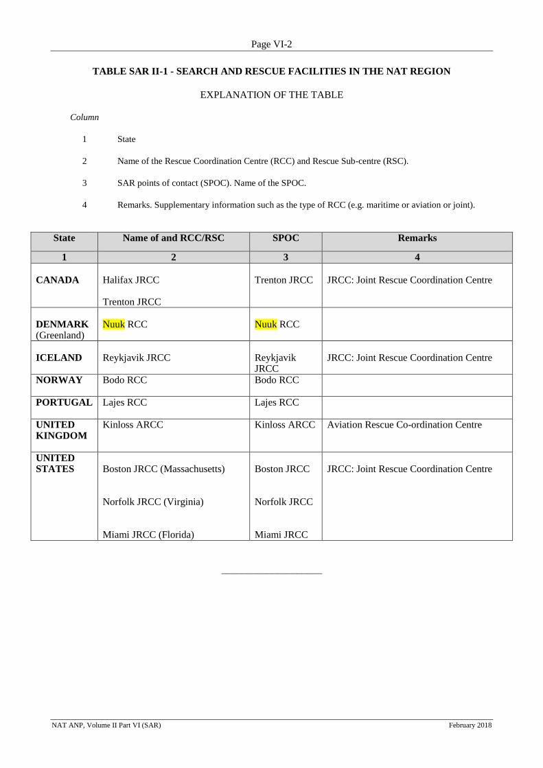
Page VI-2
NAT ANP, Volume II Part VI (SAR) February 2018
TABLE SAR II-1 - SEARCH AND RESCUE FACILITIES IN THE NAT REGION
EXPLANATION OF THE TABLE
Column
1 State
2 Name of the Rescue Coordination Centre (RCC) and Rescue Sub-centre (RSC).
3 SAR points of contact (SPOC). Name of the SPOC.
4 Remarks. Supplementary information such as the type of RCC (e.g. maritime or aviation or joint).
State Name of and RCC/RSC SPOC Remarks
1 2 3 4
CANADA
Halifax JRCC Trenton JRCC
Trenton JRCC
JRCC: Joint Rescue Coordination Centre
DENMARK (Greenland)
Nuuk RCC
Nuuk RCC
ICELAND
Reykjavik JRCC
Reykjavik JRCC
JRCC: Joint Rescue Coordination Centre
NORWAY
Bodo RCC Bodo RCC
PORTUGAL
Lajes RCC Lajes RCC
UNITED KINGDOM
Kinloss ARCC Kinloss ARCC Aviation Rescue Co-ordination Centre
UNITED STATES
Boston JRCC (Massachusetts) Norfolk JRCC (Virginia) Miami JRCC (Florida)
Boston JRCC Norfolk JRCC Miami JRCC
JRCC: Joint Rescue Coordination Centre
____________________
Page VII-1
NAT ANP, Volume II Part VII (AIM) November 2017
NAT ANP, VOLUME II
PART VII - AERONAUTICAL INFORMATION MANAGEMENT (AIM)
1. INTRODUCTION
1.1 This part of the NAT ANP, Volume II, complements the provisions in ICAO SARPs and
PANS related to AIS/AIM and aeronautical charts (MAP). It contains dynamic plan elements related to the
assignment of responsibilities to States for the provision of AIS/AIM facilities and services within a
specified area in accordance with Article 28 of the Convention on International Civil Aviation (Doc 7300);
and mandatory requirements related to the AIS/AIM facilities and services to be implemented by States in
accordance with regional air navigation agreements. Such agreement indicates a commitment on the part of
the State(s) concerned to implement the requirement(s) specified.
2. GENERAL REGIONAL REQUIREMENTS
2.1 The responsibility for the provision of AIS/AIM facilities and services in the NAT Region, is
reflected in the Table AIM II-1, which shows the list of designated international NOTAM Offices (NOF),
designated States for AIP production, designated States for aeronautical charts (MAP) production,
designated States for the provision of the authoritative Integrated Aeronautical Information Database (IAID)
and designated States for the provision of pre-flight information services.
2.2 States should designate and implement an authoritative Integrated Aeronautical Information
Database (IAID) where data sets are integrated and used to produce current and future AIS/AIM products
and services, which is a fundamental step in the transition to AIM. The designation of authoritative databases
should be clearly stated in the Aeronautical Information Package AIP.
2.3 The national plans for the transition from AIS to AIM identifying clearly the timelines for
the implementation of the different elements of the ICAO Roadmap for the transition from AIS to AIM
should be submitted by States to the ICAO EUR/NAT Regional Office. States should also inform the ICAO
EUR/NAT Regional Office of any update.
2.4 States should take necessary measures to ensure that aeronautical information and data they
provide meet the regulatory aeronautical data quality requirements.
2.5 The Quality Management System (QMS) in AIS/AIM should define procedures to meet the
safety and security objectives associated with the management of aeronautical data and information.
2.6 Recognizing the need to maintain or enhance existing safety levels of operations, States
should ensure that any change to the existing systems or the introduction of new systems used for processing
aeronautical data and/or information are preceded by a safety assessment.
2.7 Technical services responsible for origination of the raw aeronautical information should be
acquainted with the requirements for promulgation and advance notification of changes that are operationally
significant as established in Annexes 11 and 14 and other relevant ICAO documentation. They should take
due account of the time needed by AIS/AIM for the preparation, production and issue of the relevant
material, including the compliance with the AIRAC procedures.
2.8 AIS/AIM personnel should be involved in the air navigation planning processes. This should
ensure the timely preparation of appropriate AIS documentation and that the effective dates for changes to
the air navigation system and procedures are satisfied.
2.9 States should produce relevant aeronautical charts required for civil air operations employing
visual air navigation independently or in support of other forms of air navigation. The production
Page VII-2
NAT ANP, Volume II Part VII (AIM) November 2017
responsibility for sheets of the World Aeronautical Chart (WAC) — ICAO 1: 1 000 000 or Aeronautical
Chart — ICAO 1: 500 000 (as an alternative to the World Aeronautical Chart — ICAO 1:1 000 000) is set
out in Table AIM II-2.
3. SPECIFIC REGIONAL REQUIREMENTS
3.1 None.
_____________________
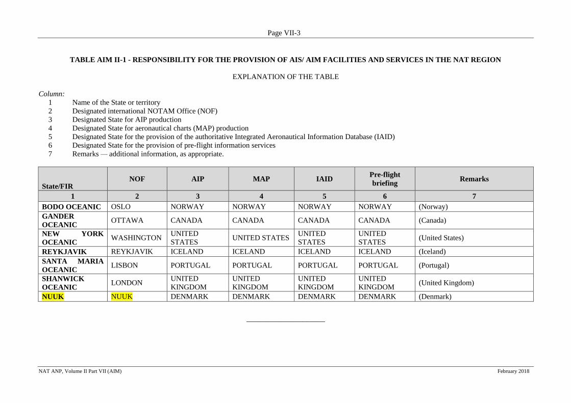
Page VII-3
NAT ANP, Volume II Part VII (AIM) February 2018
TABLE AIM II-1 - RESPONSIBILITY FOR THE PROVISION OF AIS/ AIM FACILITIES AND SERVICES IN THE NAT REGION
EXPLANATION OF THE TABLE
Column:
1 Name of the State or territory
2 Designated international NOTAM Office (NOF)
3 Designated State for AIP production
4 Designated State for aeronautical charts (MAP) production
5 Designated State for the provision of the authoritative Integrated Aeronautical Information Database (IAID)
6 Designated State for the provision of pre-flight information services
7 Remarks — additional information, as appropriate.
State/FIR NOF AIP MAP IAID
Pre-flight
briefing Remarks
1 2 3 4 5 6 7
BODO OCEANIC OSLO NORWAY NORWAY NORWAY NORWAY (Norway)
GANDER
OCEANIC OTTAWA CANADA CANADA CANADA CANADA (Canada)
NEW YORK
OCEANIC WASHINGTON
UNITED
STATES UNITED STATES
UNITED
STATES
UNITED
STATES (United States)
REYKJAVIK REYKJAVIK ICELAND ICELAND ICELAND ICELAND (Iceland)
SANTA MARIA
OCEANIC LISBON PORTUGAL PORTUGAL PORTUGAL PORTUGAL (Portugal)
SHANWICK
OCEANIC LONDON
UNITED
KINGDOM
UNITED
KINGDOM
UNITED
KINGDOM
UNITED
KINGDOM (United Kingdom)
NUUK NUUK DENMARK DENMARK DENMARK DENMARK (Denmark)
_____________________
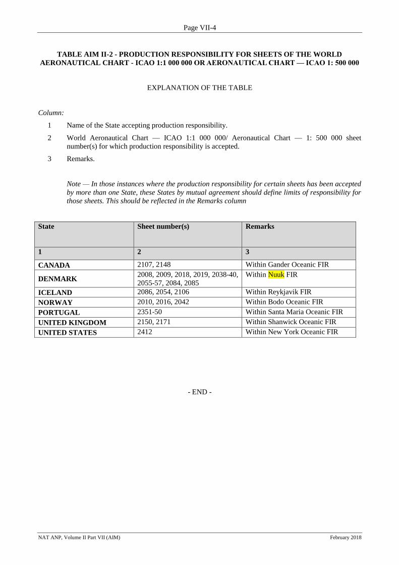
Page VII-4
NAT ANP, Volume II Part VII (AIM) February 2018
TABLE AIM II-2 - PRODUCTION RESPONSIBILITY FOR SHEETS OF THE WORLD
AERONAUTICAL CHART - ICAO 1:1 000 000 OR AERONAUTICAL CHART — ICAO 1: 500 000
EXPLANATION OF THE TABLE
Column:
1 Name of the State accepting production responsibility.
2 World Aeronautical Chart — ICAO 1:1 000 000/ Aeronautical Chart — 1: 500 000 sheet
number(s) for which production responsibility is accepted.
3 Remarks.
Note — In those instances where the production responsibility for certain sheets has been accepted
by more than one State, these States by mutual agreement should define limits of responsibility for
those sheets. This should be reflected in the Remarks column
State
Sheet number(s)
Remarks
1 2 3
CANADA 2107, 2148 Within Gander Oceanic FIR
DENMARK 2008, 2009, 2018, 2019, 2038-40,
2055-57, 2084, 2085
Within Nuuk FIR
ICELAND 2086, 2054, 2106 Within Reykjavik FIR
NORWAY 2010, 2016, 2042 Within Bodo Oceanic FIR
PORTUGAL 2351-50 Within Santa Maria Oceanic FIR
UNITED KINGDOM 2150, 2171 Within Shanwick Oceanic FIR
UNITED STATES 2412 Within New York Oceanic FIR
- END -


![Lecture 15 - sites.math.washington.edu · Lecture 15 (Undetermined Coefficients) UndeterminedGoffs. Gen. Solution to Ky]: a y ' 't by ' tags O (homogeneous) yhltl s C, yftltcayzlti](https://img.pdfslide.us/doc/110x75/5f6d990017c38d21b80ba11a/lecture-15-sitesmath-lecture-15-undetermined-coefficients-undeterminedgoffs.jpg)