Embed Size (px)
Citation preview
North American Blue Carbon
Scoping Study
September 2013
Background paper
Commission for Environmental Cooperation
Please cite as:
CEC. 2013. North American Blue Carbon Scoping Study. Montreal, Canada. Commission for Environmental Cooperation. 49pp.
This report was prepared by Samantha D. Sifleet for the Secretariat of the Commission for Environmental Cooperation. The information contained herein is the responsibility of the author and does not necessarily reflect the views of the CEC, or the governments of Canada, Mexico or the United States of America.
Reproduction of this document in whole or in part and in any form for educational or non-profit purposes may be made without special permission from the CEC Secretariat, provided acknowledgment of the source is made. The CEC would appreciate receiving a copy of any publication or material that uses this document as a source.
Except where otherwise noted, this work is protected under a Creative Commons Attribution Noncommercial-No Derivative Works License.
© Commission for Environmental Cooperation, 2013
Publication Details
Publication type: Background paper Publication date: September, 2013 Original language: English Review and quality assurance procedures:
Final Party review: August, 2013 QA12.30
Disponible en français: (Sommaire de rapport)
Disponible en español: (Resumen ejecutivo)
Cover photo: Jessica Sypher
For more information:
Commission for Environmental Cooperation 393, rue St-Jacques Ouest, bureau 200 Montreal (Quebec) H2Y 1N9 Canada t 514.350.4300 f 514.350.4372 [email protected] / www.cec.org
North American Blue Carbon Scoping Study
Commission for Environmental Cooperation iii
Table of Contents
Executive summary
Key Findings .................................................................................................................... iv
Introduction ....................................................................................................................................3
What is Blue Carbon? ...................................................................................................... 3
Mangroves in North America .......................................................................................................4
Annual carbon sequestration in mangrove forests in North America ...................... 4
Carbon stocks in mangrove sediments of North America ......................................... 6
Carbon content of mangrove forest biomass in North America ................................ 7
Mangrove extent and overlap with MPAs in North America ...................................... 9
Emissions from mangrove loss in North America ..................................................... 12
Salt Marshes in North America ..................................................................................................13
Annual carbon sequestration rates in salt marshes in North America ................... 13
Carbon stocks in salt marsh sediments of North America ....................................... 15
Carbon content of salt marsh biomass in North America ........................................ 17
Salt marsh extent and overlap with MPAs in North America .................................. 18
Emissions from salt marsh loss in North America .................................................... 20
Seagrasses in North America ......................................................................................................21
Annual carbon sequestration in seagrass meadows of North America ................. 21
Carbon stocks of seagrass sediments in North America ......................................... 23
Carbon content of seagrass biomass in North America .......................................... 25
Seagrass extent and overlap with MPAs in North America ..................................... 28
Emissions from seagrass loss in North America ....................................................... 29
Key Data Gaps & Recommendations .........................................................................................30
Literature Cited ...........................................................................................................................31
Appendix: Additional Tables and Figures .................................................................................35
North American Blue Carbon Scoping Study
Commission for Environmental Cooperation iv
Executive Summary
Coastal wetlands store large amounts of carbon in their vegetation and soils. The development of
carbon markets creates the potential for carbon offset payments for coastal wetland conservation
and restoration. A careful accounting of both the long-term storage of carbon and annual
greenhouse gas fluxes in these ecosystems is needed before carbon payments can begin.
Additionally, the geographic location of blue carbon ecosystems, namely mangrove forests, salt
marshes, and seagrass meadows, must be accurately documented prior to enrollment on the
carbon offset markets. This report examines the extent and carbon sequestration dynamics of
blue carbon ecosystems in North America. The overlap of existing marine protected areas in
North America with these coastal wetlands is explored in an effort to assess the current size of
the blue carbon market in North America.
Key Findings
1. A lack of accurate geospatial data for salt marsh and seagrass ecosystems is the greatest
hurdle for the blue carbon market in North America. Mangrove forests are the best
mapped of all the systems and the most ready for inclusion in current carbon offset
programs.
2. Variability in soil carbon stores, for both carbon density and depth, within a given
ecosystem type also presents issues in calculating total carbon sequestered. While default
mean or median values can be used initially, more accurate measurements will be needed
in the future. Depth measurements of the organic-rich peat soils lying underneath these
habitats in North America are sparse. A concerted effort to measure the depth and the
carbon density of these soils should be pursued.
3. Ecosystem stressors, such as nutrient loading and sea level rise, can shift the overall
greenhouse gas balance of blue carbon habitats. Therefore, habitat quality monitoring and
measurements should be included in the development of blue carbon offset standards.
North American Blue Carbon Scoping Study
Commission for Environmental Cooperation 1
RESUMEN EJECUTIVO
Los humedales costeros almacenan grandes cantidades de carbono en la vegetación que albergan
y en sus suelos. Con el desarrollo de los mercados de carbono se genera la posibilidad de
establecer sistemas de pagos por compensación de emisiones de carbono para la conservación y
restauración de los humedales costeros. Antes de poder iniciar e implementar estos sistemas, es
preciso cuantificar minuciosamente tanto el almacenamiento de carbono a largo plazo como los
flujos anuales de gases de efecto invernadero en estos ecosistemas. Asimismo, deberá
documentarse con toda precisión la ubicación geográfica de los ecosistemas de carbono “azul”,
principalmente manglares, marismas salobres y lechos de pasto marino, antes de proceder a
inscribirse y tomar parte en los mercados de compensación de emisiones de carbono. En el
presente informe se examina el alcance y la dinámica del secuestro de carbono de los
ecosistemas de carbono “azul” a escala de América del Norte. Asimismo, en un esfuerzo por
evaluar la dimensión que alcanza actualmente el mercado del carbono “azul” en la región, se
explora el traslape entre las áreas marinas protegidas existentes en América del Norte y estos
humedales costeros.
Principales conclusiones
1. La falta de datos geoespaciales precisos relacionados con los ecosistemas de marismas
salobres y lechos de pasto marino constituye el mayor obstáculo para la creación de un
mercado de carbono “azul” en América del Norte. Los manglares, por su parte, además
de ser los sistemas mejor cartografiados, son los que más prontamente pueden incluirse
en programas de compensación de emisiones de carbono en vigor.
2. La variabilidad en las reservas de carbono en el suelo dentro de un tipo de ecosistema
dado, lo mismo en términos de densidad de carbono que de profundidad, supone otro de
los problemas para poder calcular el total de carbono captado y almacenado. Aunque
inicialmente pueden emplearse valores medianos o promedio por omisión, en el futuro se
requerirán mediciones más precisas. Sin embargo, aún son escasas las mediciones de la
profundidad de los suelos de turba ricos en materia orgánica que subyacen estos hábitats
de América del Norte. Por lo tanto, deberán procurarse iniciativas concertadas
encaminadas a medir la profundidad de estos suelos y la densidad del carbono en ellos
almacenado.
3. Ciertos factores de presión ambiental, como la carga de nutrientes y el aumento en el
nivel del mar, pueden modificar el equilibrio global de los gases de efecto invernadero en
los hábitats de carbono “azul”. Por ello habrán de incluirse actividades de monitoreo y
medición de la calidad de los hábitats cuando se establezcan estándares en materia de
compensación de emisiones de carbono “azul”.

North American Blue Carbon Scoping Study
Commission for Environmental Cooperation 2
Sommaire de rapport
De grandes quantités de carbone sont stockées dans la végétation et le sol des terres humides
côtières. Les marchés du carbone pourraient financer les activités de conservation et de
restauration des terres humides côtières avec les crédits de compensation de carbone. Il faut
cependant déterminer avec exactitude le stockage à long terme du carbone et les flux d’émissions
de gaz à effet de serre dans ces écosystèmes avant d’établir les paiements compensatoires. En
outre, il faut documenter avec exactitude l’emplacement géographique des écosystèmes de
carbone bleu, c’est-à-dire les mangroves, les marais salés et les herbiers marins avant de prendre
part à un système de compensation des émissions de carbone. Le rapport examine l’étendue des
écosystèmes du carbone bleu et les principes de la séquestration du carbone dans ces
écosystèmes en Amérique du Nord. On s’intéresse au chevauchement d’aires marines protégées
en Amérique du Nord et de ces terres humides côtières afin d’évaluer la taille actuelle du marché
du carbone bleu en Amérique du Nord.
Principales constatations
1. Le manque de données géospatiales précises au sujet des écosystèmes de marais salés et
d’herbiers marins constitue le plus gros obstacle à la création d’un marché du carbone
bleu en Amérique du Nord. De tous les systèmes, ce sont les mangroves qui sont le mieux
cartographiées et le plus aptes à être incluses dans les programmes actuels de
compensation de carbone.
2. Le fait que les puits de carbone diffèrent sur les plans de la densité du carbone et de la
profondeur à l’intérieur d’un type d’écosystème donné complique également le calcul de
la quantité de carbone séquestré. On peut utiliser des valeurs moyennes ou médianes par
défaut au début, mais à terme, il faudra des mesures plus précises. Il existe peu de
données sur la profondeur des sols tourbeux riches en matières organiques qui se trouvent
sous ces habitats en Amérique du Nord. Il faudrait mener des activités concertées pour
mesurer la profondeur et la densité du carbone stocké dans ces sols.
3. Les facteurs d’agression des écosystèmes, comme la charge en éléments nutritifs et
l’élévation du niveau de la mer, peuvent modifier l’équilibre des gaz à effet de serre dans
les habitats stockant du carbone bleu. Il faut donc inclure la surveillance et l’évaluation
de la qualité de l’habitat dans l’élaboration de normes relatives à la compensation du
carbone bleu.
North American Blue Carbon Scoping Study
Commission for Environmental Cooperation 3
Introduction
Consensus within the scientific community connects rising levels of anthropogenic greenhouse
gases (GHGs) with climate change (Solomon et al. 2007). The majority of GHG emissions result
from burning fossil fuels; yet, a sizeable portion (8-20%) derive from land-use change and
deforestation (Van der Werf et al. 2009). The international community now looks toward
conservation efforts to minimize GHG emissions due to deforestation. One example of this is the
Reduced Emissions from Deforestation and Degradation (REDD+) program, which provides
financial incentives to forest conservation efforts and requires intensive monitoring of
sequestered carbon and GHG emissions (Agrawal, Nepstad, and Chatre 2011).
Recently, attention has focused on the ability of coastal wetland ecosystems to sequester carbon
(Laffoley and Grimsditch 2009; Nellemann et al. 2009). While coastal wetlands tend to store less
carbon in biomass than their terrestrial counterparts, the sediments underlying these systems
have much greater storage capacity than terrestrial systems for several reasons. Coastal wetland
soils accrete vertically overtime, keeping pace with sea level rise, to a point (Mudd, Howell, and
Morris 2009). The saline and associated anaerobic nature of these sediments allows for the burial
of organic matter into high carbon peat soils (Livesley and Andrusiak 2012). These coastal
ecosystems act as sediment traps for runoff from terrestrial systems and other suspended solids;
Kennedy and others (2010) calculate that 50% of carbon sequestered in seagrass sediments
originates from external sources.
These “blue carbon” systems – mangroves, salt marshes, and seagrasses – cover less than 2% of
the area of the world’s oceans and sequester at least 50% of the carbon stored in ocean sediments
(Nellemann et al. 2009). As the value of these systems in mitigating climate change is
recognized, market incentives similar to REDD+ are developing. In the fall of 2012, the Verified
Carbon Standard (VCS) recognized blue carbon within the Wetlands Restoration and
Conservation (WRC) projects for carbon credits (VCS 2012). As blue carbon standards develop,
a need for accurate accounting of carbon storage in coastal wetlands is paramount.
Opportunities for carbon payments to protect sequestered blue carbon already exist. The North
American Marine Protected Areas Network (NAMPAN) consists of over 2000 marine protected
areas (MPAs) throughout North America. However, the alignment of blue carbon systems with
MPAs is not clear. The purpose of this report is to both explore the connections and identify the
data gaps in quantifying blue carbon within the North American MPAs.
What is Blue Carbon?
Blue carbon is defined as the carbon1 stored in coastal wetland ecosystems such as mangroves,
salt marshes and seagrasses. These systems sequester carbon in multiple ways. First, there is the
biomass component of the system. This includes both the aboveground (branches and leaves) and
belowground (roots) pools of carbon stored in the plants of the system. This biomass pool of
carbon ranges from relatively high in mangrove forests (higher even than in terrestrial forests) to
relatively low in seagrass meadows (Fourqurean et al. 2012). The carbon stored in the sediments
1 Each gram of organic carbon, stored either as biomass or soil, represents 3.67 CO2 equivalents.
North American Blue Carbon Scoping Study
Commission for Environmental Cooperation 4
underlying blue carbon systems far exceeds that stored in the biomass. This long term storage of
carbon may or may not be permanent. If the ecosystem is converted to another use – i.e.
mangroves are deforested, salt marshes are drained, or seagrass beds are dredged – the carbon
stored in the carbon rich peat sediments can be oxidized and released. Restoration of these
systems does not necessarily result in the restoration of the soil carbon pool. The last component
of blue carbon to consider is the annual sequestration rate; this is the amount of carbon added to
the sediment pool each year. This rate can be restored with ecosystem restoration efforts.
Much work has already gone into quantifying the carbon pools and fluxes associated with blue
carbon systems. This report updates a report and data set from 2011 entitled “State of the Science
on Coastal Blue Carbon: A Summary for Policy Makers” (Sifleet, Pendleton, and Murray 2011).
The main findings of this previous work show wide variations across the three ecosystem types
in reported annual carbon sequestration rates (the majority of the observations reporting 7 Mg
CO2eha-1
yr-1
or less) and carbon storage in the top meter of soil (typically ranging from 800 to
2000 Mg CO2eha-1
). Carbon stored in biomass is much more dependent on system type;
mangrove forests have much greater biomass, and associated carbon, than both salt marsh and
seagrass systems. This previous report also underscored the paucity of data on the carbon density
of seagrass sediments. The major issue in quantifying how much carbon is sequestered within a
given blue carbon system is identifying the extent of the system and the depth of the sediment
pool beneath it.
Mangroves in North America
Mangrove forests are coastal wetland forests that cover up to 75% of the tropical and subtropical
shorelines of the world. In North America, mangroves occur in Mexico and the U.S. but not as
far north as Canada. The distinctive characteristics of mangroves include aerial roots, stilt roots,
salt-excreting leaves, and floating salt-tolerant seedlings. Mangrove diversity is highest in Asia.
In North America and Africa mangrove forests are dominated by one of three species: the red
mangroves (Rhizophora mangle L.), the black mangroves (Avicennia germinans L.), and the
white mangroves (Laguncularia racemosa) (Kuenzer et al. 2011). Mangroves have wet anaerobic
sediments that accumulate over time. The depth of these carbon-rich soils varies based on
geomorphology. For example, mangroves in estuaries tend to have greater depths of organic soils
than oceanic mangroves, which have a hard sandy or rocky substrate (Donato et al. 2011).
Annual carbon sequestration in mangrove forests in North America
The annual carbon sequestration rate of mangrove forests in North America is related to the
litterfall rate (Sanchez-Carrillo et al. 2009). However, many of the estimates presented in the
literature are derived from sediment cores that are dated using Cs or Pb 210. For North America,
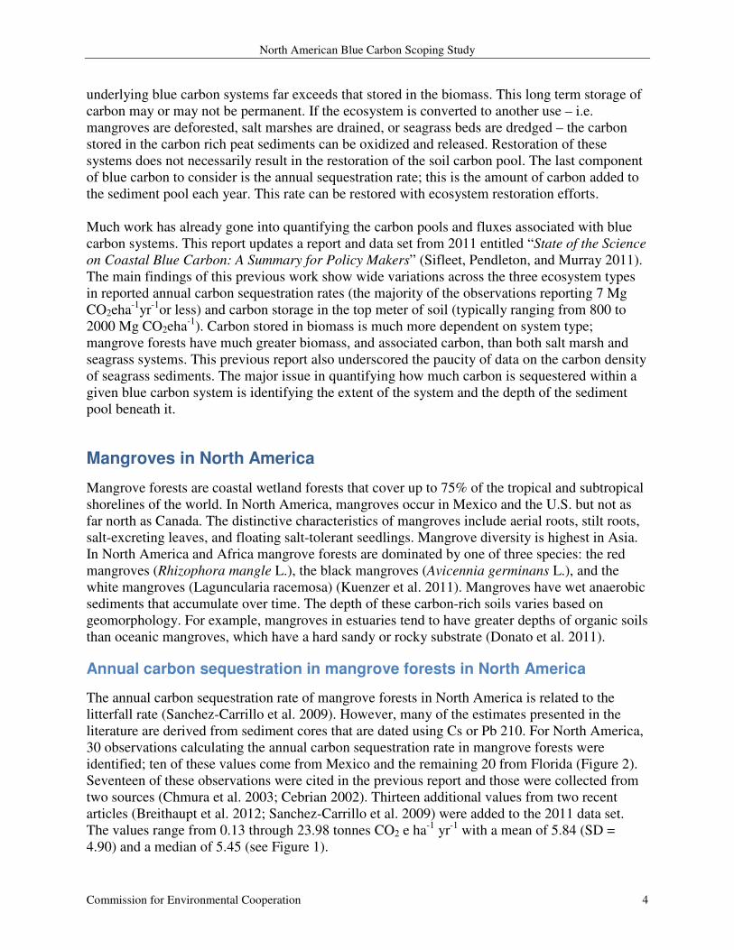
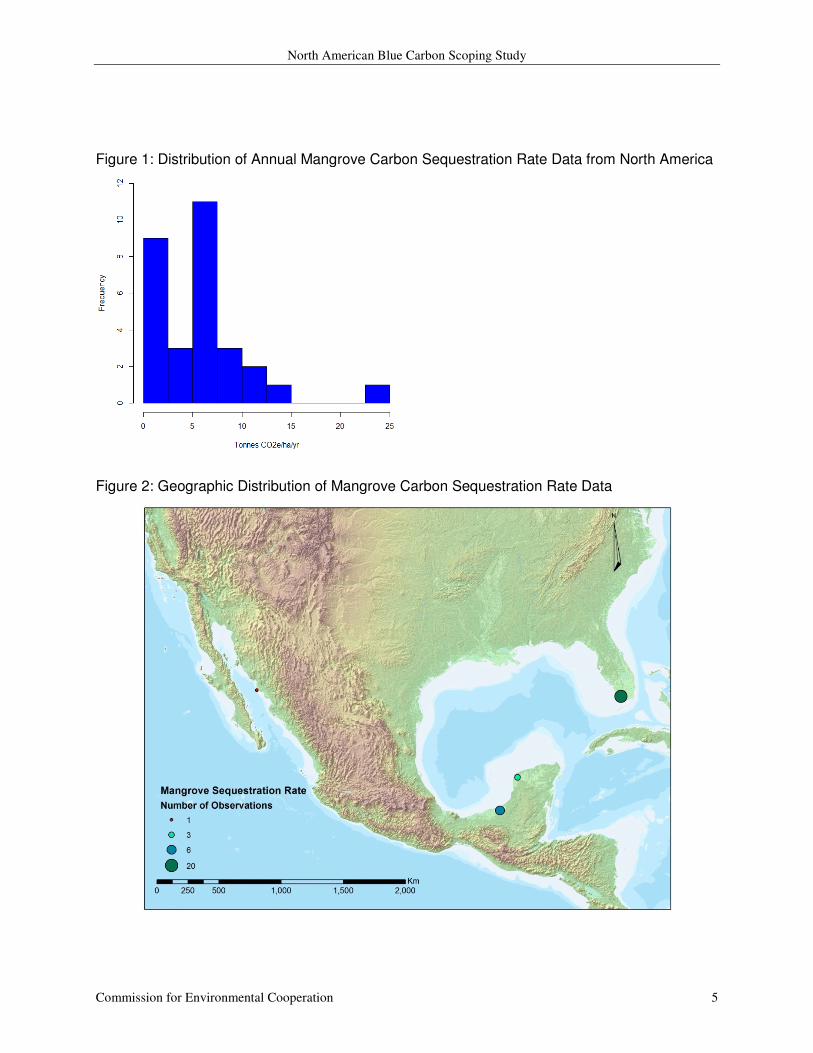
30 observations calculating the annual carbon sequestration rate in mangrove forests were
identified; ten of these values come from Mexico and the remaining 20 from Florida (Figure 2).
Seventeen of these observations were cited in the previous report and those were collected from
two sources (Chmura et al. 2003; Cebrian 2002). Thirteen additional values from two recent
articles (Breithaupt et al. 2012; Sanchez-Carrillo et al. 2009) were added to the 2011 data set.
The values range from 0.13 through 23.98 tonnes CO2 e ha-1
yr-1
with a mean of 5.84 (SD =
4.90) and a median of 5.45 (see Figure 1).
North American Blue Carbon Scoping Study
Commission for Environmental Cooperation 5
Figure 1: Distribution of Annual Mangrove Carbon Sequestration Rate Data from North America
Figure 2: Geographic Distribution of Mangrove Carbon Sequestration Rate Data
North American Blue Carbon Scoping Study
Commission for Environmental Cooperation 6
Carbon stocks in mangrove sediments of North America
The peat deposits beneath mangrove forests can reach depths of up to 10 meters (Alongi et al.
1999). However, no observations of mangrove peat depth in North America were found. While
the depth of mangrove peats are dependent upon local geomorphology (Donato et al. 2011), the
general assumption made is that they are at least a meter deep (Donato et al. 2012; Pendleton et
al. 2012; Sifleet, Pendleton, and Murray 2011).
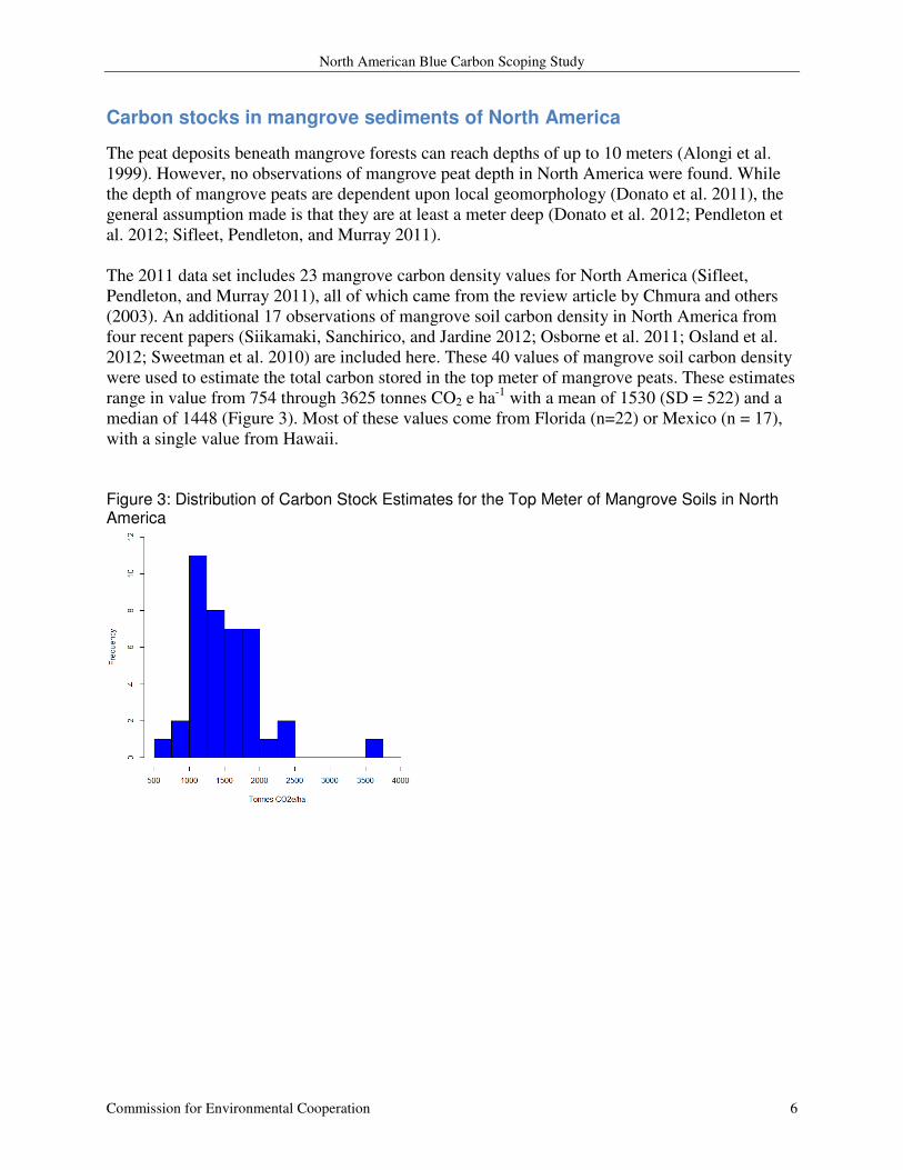
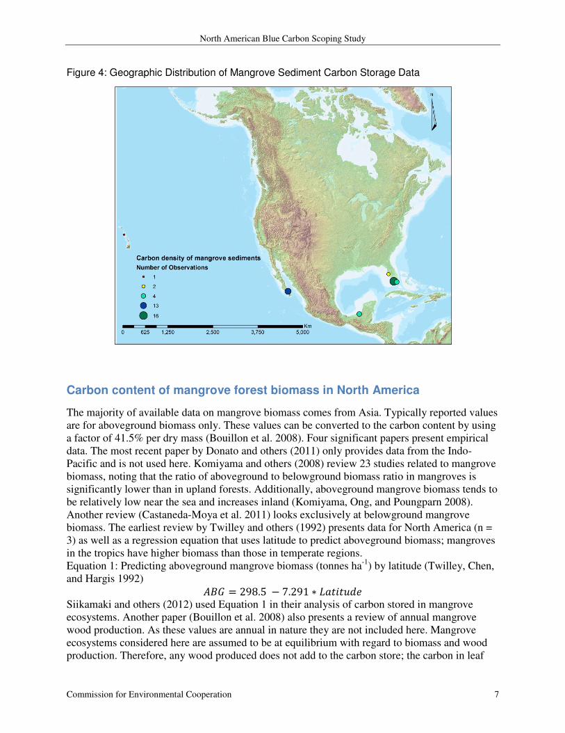
The 2011 data set includes 23 mangrove carbon density values for North America (Sifleet,
Pendleton, and Murray 2011), all of which came from the review article by Chmura and others
(2003). An additional 17 observations of mangrove soil carbon density in North America from
four recent papers (Siikamaki, Sanchirico, and Jardine 2012; Osborne et al. 2011; Osland et al.
2012; Sweetman et al. 2010) are included here. These 40 values of mangrove soil carbon density
were used to estimate the total carbon stored in the top meter of mangrove peats. These estimates
range in value from 754 through 3625 tonnes CO2 e ha-1
with a mean of 1530 (SD = 522) and a
median of 1448 (Figure 3). Most of these values come from Florida (n=22) or Mexico (n = 17),
with a single value from Hawaii.
Figure 3: Distribution of Carbon Stock Estimates for the Top Meter of Mangrove Soils in North America
North American Blue Carbon Scoping Study
Commission for Environmental Cooperation 7
Figure 4: Geographic Distribution of Mangrove Sediment Carbon Storage Data
Carbon content of mangrove forest biomass in North America
The majority of available data on mangrove biomass comes from Asia. Typically reported values
are for aboveground biomass only. These values can be converted to the carbon content by using
a factor of 41.5% per dry mass (Bouillon et al. 2008). Four significant papers present empirical
data. The most recent paper by Donato and others (2011) only provides data from the Indo-
Pacific and is not used here. Komiyama and others (2008) review 23 studies related to mangrove
biomass, noting that the ratio of aboveground to belowground biomass ratio in mangroves is
significantly lower than in upland forests. Additionally, aboveground mangrove biomass tends to
be relatively low near the sea and increases inland (Komiyama, Ong, and Poungparn 2008).
Another review (Castaneda-Moya et al. 2011) looks exclusively at belowground mangrove
biomass. The earliest review by Twilley and others (1992) presents data for North America (n =
3) as well as a regression equation that uses latitude to predict aboveground biomass; mangroves
in the tropics have higher biomass than those in temperate regions.
Equation 1: Predicting aboveground mangrove biomass (tonnes ha-1
) by latitude (Twilley, Chen,
and Hargis 1992)
��� = 298.5 − 7.291 ∗ �������� Siikamaki and others (2012) used Equation 1 in their analysis of carbon stored in mangrove
ecosystems. Another paper (Bouillon et al. 2008) also presents a review of annual mangrove
wood production. As these values are annual in nature they are not included here. Mangrove
ecosystems considered here are assumed to be at equilibrium with regard to biomass and wood
production. Therefore, any wood produced does not add to the carbon store; the carbon in leaf
North American Blue Carbon Scoping Study
Commission for Environmental Cooperation 8
litter and branches that fall to the ground is assumed to be incorporated into the annual
sequestration rate to the sediment pool. Sanchez-Cariilo and others (2009) found litter fall to be
roughly equivalent with the annual sequestration rate or export to the local sediment pool.
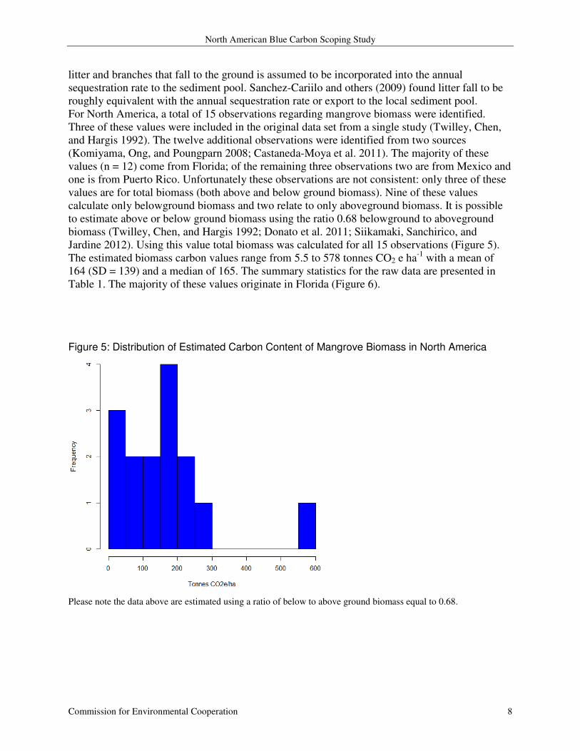
For North America, a total of 15 observations regarding mangrove biomass were identified.
Three of these values were included in the original data set from a single study (Twilley, Chen,
and Hargis 1992). The twelve additional observations were identified from two sources
(Komiyama, Ong, and Poungparn 2008; Castaneda-Moya et al. 2011). The majority of these
values (n = 12) come from Florida; of the remaining three observations two are from Mexico and
one is from Puerto Rico. Unfortunately these observations are not consistent: only three of these
values are for total biomass (both above and below ground biomass). Nine of these values
calculate only belowground biomass and two relate to only aboveground biomass. It is possible
to estimate above or below ground biomass using the ratio 0.68 belowground to aboveground
biomass (Twilley, Chen, and Hargis 1992; Donato et al. 2011; Siikamaki, Sanchirico, and
Jardine 2012). Using this value total biomass was calculated for all 15 observations (Figure 5).
The estimated biomass carbon values range from 5.5 to 578 tonnes CO2 e ha-1
with a mean of
164 (SD = 139) and a median of 165. The summary statistics for the raw data are presented in
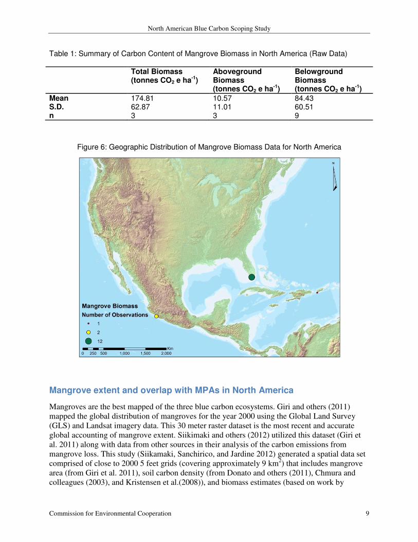
Table 1. The majority of these values originate in Florida (Figure 6).
Figure 5: Distribution of Estimated Carbon Content of Mangrove Biomass in North America
Please note the data above are estimated using a ratio of below to above ground biomass equal to 0.68.
North American Blue Carbon Scoping Study
Commission for Environmental Cooperation 9
Table 1: Summary of Carbon Content of Mangrove Biomass in North America (Raw Data)
Total Biomass (tonnes CO2 e ha-1)
Aboveground Biomass (tonnes CO2 e ha-1)
Belowground Biomass (tonnes CO2 e ha-1)
Mean 174.81 10.57 84.43 S.D. 62.87 11.01 60.51 n 3 3 9
Figure 6: Geographic Distribution of Mangrove Biomass Data for North America
Mangrove extent and overlap with MPAs in North America
Mangroves are the best mapped of the three blue carbon ecosystems. Giri and others (2011)
mapped the global distribution of mangroves for the year 2000 using the Global Land Survey
(GLS) and Landsat imagery data. This 30 meter raster dataset is the most recent and accurate
global accounting of mangrove extent. Siikimaki and others (2012) utilized this dataset (Giri et
al. 2011) along with data from other sources in their analysis of the carbon emissions from
mangrove loss. This study (Siikamaki, Sanchirico, and Jardine 2012) generated a spatial data set
comprised of close to 2000 5 feet grids (covering approximately 9 km2) that includes mangrove
area (from Giri et al. 2011), soil carbon density (from Donato and others (2011), Chmura and
colleagues (2003), and Kristensen et al.(2008)), and biomass estimates (based on work by

North American Blue Carbon Scoping Study
Commission for Environmental Cooperation 10
Twilley and others (1992) and Donato and colleagues (2011)). Dr. Siikamaki provided the spatial
data used here to explore the overlap between mangrove systems and MPAs in North America
(Figure 7).
Figure 7: Overlap of Mangrove Ecosystems and Marine Protected Areas in North America
The spatial units available within the Siikamaki data set are large, roughly 9 km2. The mangrove
area values within these large spatial units are derived from the much finer scale Giri et al.
(2011) data set. The Giri et al. (2011), with 30 m x 30 m pixels, was used to examine the overlap
of mangrove ecosystems with the North American MPAs. Briefly, the data from Giri et al.
(2011) was extracted for just the US and Mexico, as mangroves do not occur in Canada. Then
the occurrence of mangrove systems was summarized for each overlapping MPA.
The total area of mangrove forests in North America is 10,166 km2, with 2,548 km
2 in the United
States and 7,618 km2 in Mexico (Giri et al. 2011). Roughly 42% (4,282km
2) of mangrove forests
in North America lie within the bounds of a marine protected area. The majority of this area lies
in Mexico where roughly 2,364 km2 of mangrove forests intersect with 18 different MPAs.
Within the United States 1,918 km2 of mangrove ecosystems overlap with 155 unique MPAs. A

North American Blue Carbon Scoping Study
Commission for Environmental Cooperation 11
full list of the MPAs identified as containing mangroves and the estimated area lying within
them can be found in the Appendix (Table A.1 and Table A.2).
The US National Ocean and Air Administration (NOAA) manages the US MPAs and has
documented the presence of blue carbon habitats within the US MPAs2. The tabular data
available from NOAA (presented in the Appendix as Table A.3) identifies 168 US MPAs as
containing mangrove forests (Figure 8). The alignment of this NOAA list with the list derived
from the Giri et al. (2011) data set is not good. Of the 168 US MPAs identified by NOAA as
containing mangroves, only 98 are identified by the Giri et al. (2011) data and included in table
A.1. Hence, the NOAA data identifies an additional 70 U.S. MPAs as containing mangroves
compared to this analysis of the Giri et al. (2011) data. . On the other hand, 57 U.S. MPAs
identified by this analysis of the Giri et al. (2011) data (Table A.1) are not included in the NOAA
data set (Table A.3).
Figure 8: US MPAs Containing Mangroves as documented by NOAA
2 Tabular data received via personal communication on 14/12/2012 with Jordan Glass, GIS Specialist for the
Pacific Regional Ocean Uses Atlas Project and National Marine Protected Areas Center
99 Pacific St. Suite 100F Monterey, CA 93940 [email protected] (831) 647-6464
http://www.mpa.gov
North American Blue Carbon Scoping Study
Commission for Environmental Cooperation 12
Emissions from mangrove loss in North America
Mangrove loss rates in North and Central America averaged about 0.8% per year from 2000 to
2005 (FAO 2007). As mangrove forests are cleared and converted to other land uses, GHGs are
released to the atmosphere (Lovelock, Ruess, and Feller 2011). The method of conversion and
the final land use type of the converted land impact the amount of GHGs released to the
atmosphere. Lovelock and others (2011) observed a release of 29 tonnes of CO2ha-1
yr-1
released
when a mangrove forest in Belize was cleared. It is also possible for natural damage of mangrove
systems (i.e. hurricanes) to cause the release and/or diminished sequestration of carbon in
mangrove ecosystems (Barr et al. 2012).
North American Blue Carbon Scoping Study
Commission for Environmental Cooperation 13
Salt Marshes in North America
Salt marshes are coastal wetland ecosystems dominated by grasses. These wetlands occur on
coastlines where wave action is generally low and they lie along the tidal interface through a
range of salinity. Salt marshes act as a carbon sink for a variety of reasons. Carbon is stored in
sediments that settle out as freshwater travels into the marsh and experiences a drop in velocity.
In this manner, marshes trap carbon from large drainage areas. Marsh sediments accrete
vertically over time, keeping pace with sea level rise to a point. The anaerobic nature of salt
marsh soils enables the long term burial of organic carbon.
Annual carbon sequestration rates in salt marshes in North America
The annual carbon sequestration rate in salt marshes is dependent upon multiple factors
including salinity, nutrient loading, and the combined impacts of climate change. The
biogeochemistry of salt marsh sediments is very complex, especially when considering
greenhouse gases. The anaerobic nature of marsh sediments means that methane and nitrous
oxide production is possible. Both of these gases have higher global warming potentials (GWP)
than carbon dioxide; methane has GWP of 25 CO2 equivalents over 100 years and nitrous oxide
has GWP of 298 CO2 equivalents over 100 years. The balance of carbon buried in the sediment
pool compared to the production of other GHGs must be considered. Salinity is a defining
characteristic of whether a marsh acts as a net GHG sink or source (Poffenbarger, Needelman,
and Megonigal 2011; Chmura, Kellman, and Guntenspergen 2011). Poffenbarger and others
(2011) conducted a meta-analysis to explore the relationship between salinity, methane
production, and carbon sequestration in marsh sediments. Their findings indicate that marshes
with salinity greater than 18 ppt emit negligible amounts of methane; marshes with salinity
values of less than 18 ppt may emit enough methane to counter the carbon stored in sediments
(Poffenbarger, Needelman, and Megonigal 2011). Thus, salt marshes are defined here as those
with salinity values greater than 18 ppt.
Nutrient loads in salt marshes have the potential to impact the balance of GHGs in salt marshes.
Irvine and others (2012) found a positive linear relationship between nitrogen enrichment and
methane production in three California salt marshes. Deegan and others (2012) examined the
impacts of nitrogen enrichment over a nine-year period. They observed significantly higher
fluxes of nitrous oxide in the enriched vs. the reference marshes. Also observed were decreased
amounts of belowground biomass and increased microbial decomposition in the enriched
marshes. These factors are likely responsible for the decreased stability of the enriched marshes
as measured with multiple geomorphic variables. Another study also found that short term
nitrogen enrichment led to increased N2O emissions, most notably in the summer months
(Moseman-Valtierra et al. 2011).
Salt marsh sediment accretion rates are linked with sea level rise and soil volume is roughly
equivalent with marsh elevation (Kirwan and Mudd 2012). The impacts of climate change on
carbon sequestration in salt marshes are complex. Multiple studies show that sediment accretion
rates will likely increase and keep pace with sea level rise, as long as the rise occurs at a
moderate level (Kirwan and Mudd 2012). Drastic changes in relative sea level (i.e. from the
combination of eustatic sea level rise and marsh subsidence) can result in marsh die-off and peat
collapse (DeLaune and White 2012). A warmer climate may result in higher rates of decay
North American Blue Carbon Scoping Study
Commission for Environmental Cooperation 14
leading to lower rates of carbon export to marsh sediments (Kirwan and Mudd 2012; Kirwan and
Blum 2011). This means that climate change may result in greater rates of sediment accretion but
not necessarily greater rates of carbon sequestration.
Carbon sequestration rates are typically measured using sediment cores. The cores are sliced into
segments and dated using either 210
Pb or 137
Cs methods. These methods may produce slightly
different results. Mudd and others (2009) note that cesium-based accumulation rates tend to be
higher than lead accretion rates when there are high rates of decomposition.
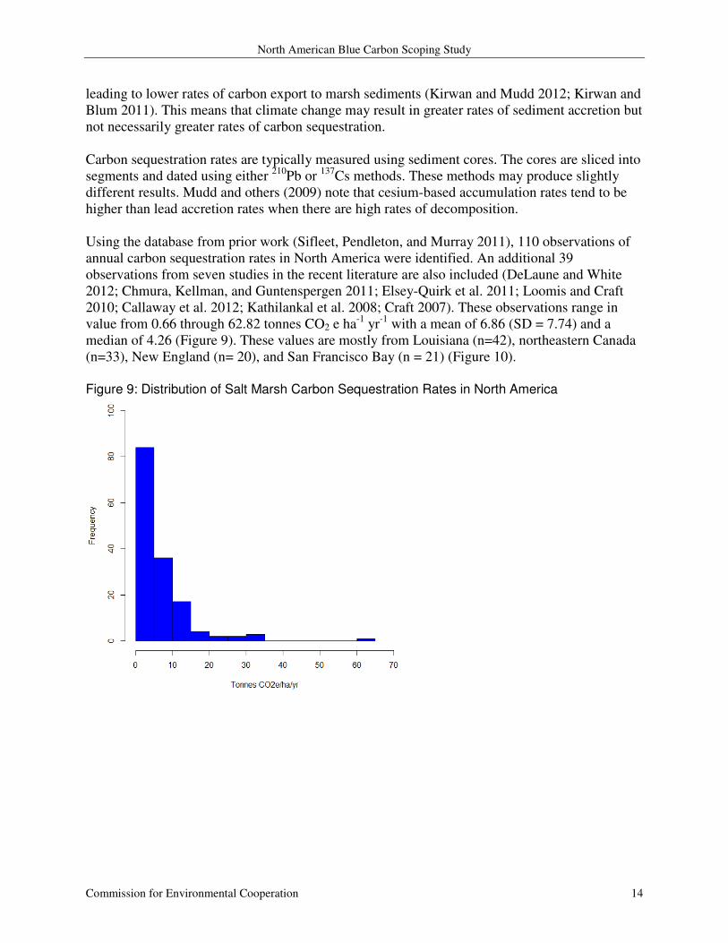
Using the database from prior work (Sifleet, Pendleton, and Murray 2011), 110 observations of
annual carbon sequestration rates in North America were identified. An additional 39
observations from seven studies in the recent literature are also included (DeLaune and White
2012; Chmura, Kellman, and Guntenspergen 2011; Elsey-Quirk et al. 2011; Loomis and Craft
2010; Callaway et al. 2012; Kathilankal et al. 2008; Craft 2007). These observations range in
value from 0.66 through 62.82 tonnes CO2 e ha-1
yr-1
with a mean of 6.86 (SD = 7.74) and a
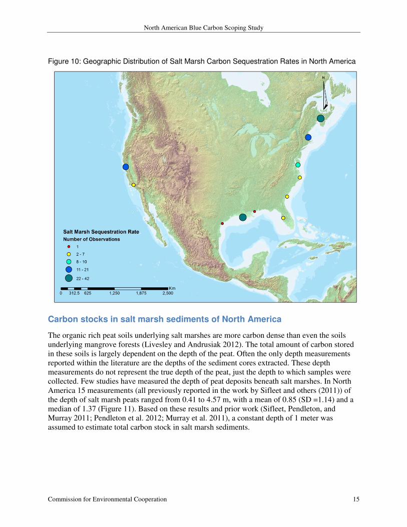
median of 4.26 (Figure 9). These values are mostly from Louisiana (n=42), northeastern Canada
(n=33), New England (n= 20), and San Francisco Bay (n = 21) (Figure 10).
Figure 9: Distribution of Salt Marsh Carbon Sequestration Rates in North America
North American Blue Carbon Scoping Study
Commission for Environmental Cooperation 15
Figure 10: Geographic Distribution of Salt Marsh Carbon Sequestration Rates in North America
Carbon stocks in salt marsh sediments of North America
The organic rich peat soils underlying salt marshes are more carbon dense than even the soils
underlying mangrove forests (Livesley and Andrusiak 2012). The total amount of carbon stored
in these soils is largely dependent on the depth of the peat. Often the only depth measurements
reported within the literature are the depths of the sediment cores extracted. These depth
measurements do not represent the true depth of the peat, just the depth to which samples were
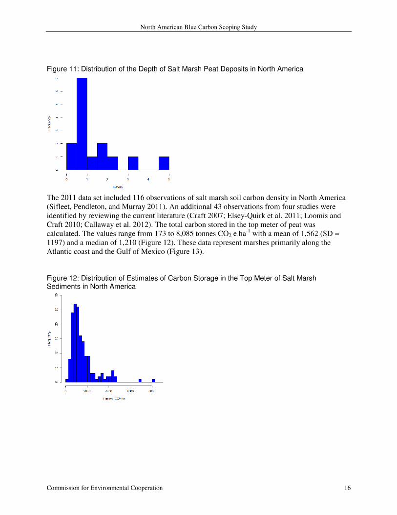
collected. Few studies have measured the depth of peat deposits beneath salt marshes. In North
America 15 measurements (all previously reported in the work by Sifleet and others (2011)) of
the depth of salt marsh peats ranged from 0.41 to 4.57 m, with a mean of 0.85 (SD =1.14) and a
median of 1.37 (Figure 11). Based on these results and prior work (Sifleet, Pendleton, and
Murray 2011; Pendleton et al. 2012; Murray et al. 2011), a constant depth of 1 meter was
assumed to estimate total carbon stock in salt marsh sediments.
North American Blue Carbon Scoping Study
Commission for Environmental Cooperation 16
Figure 11: Distribution of the Depth of Salt Marsh Peat Deposits in North America
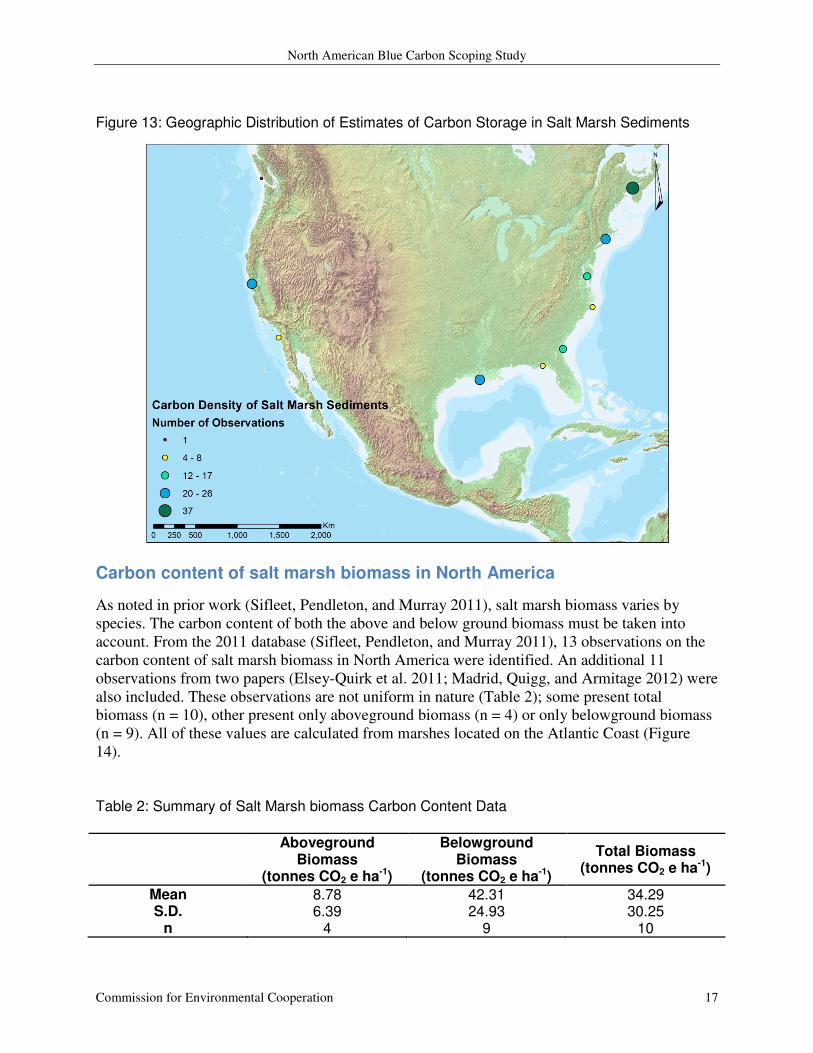
The 2011 data set included 116 observations of salt marsh soil carbon density in North America
(Sifleet, Pendleton, and Murray 2011). An additional 43 observations from four studies were
identified by reviewing the current literature (Craft 2007; Elsey-Quirk et al. 2011; Loomis and
Craft 2010; Callaway et al. 2012). The total carbon stored in the top meter of peat was
calculated. The values range from 173 to 8,085 tonnes CO2 e ha-1
with a mean of 1,562 (SD =
1197) and a median of 1,210 (Figure 12). These data represent marshes primarily along the
Atlantic coast and the Gulf of Mexico (Figure 13).
Figure 12: Distribution of Estimates of Carbon Storage in the Top Meter of Salt Marsh Sediments in North America
North American Blue Carbon Scoping Study
Commission for Environmental Cooperation 17
Figure 13: Geographic Distribution of Estimates of Carbon Storage in Salt Marsh Sediments
Carbon content of salt marsh biomass in North America
As noted in prior work (Sifleet, Pendleton, and Murray 2011), salt marsh biomass varies by
species. The carbon content of both the above and below ground biomass must be taken into
account. From the 2011 database (Sifleet, Pendleton, and Murray 2011), 13 observations on the
carbon content of salt marsh biomass in North America were identified. An additional 11
observations from two papers (Elsey-Quirk et al. 2011; Madrid, Quigg, and Armitage 2012) were
also included. These observations are not uniform in nature (Table 2); some present total
biomass (n = 10), other present only aboveground biomass (n = 4) or only belowground biomass
(n = 9). All of these values are calculated from marshes located on the Atlantic Coast (Figure
14).
Table 2: Summary of Salt Marsh biomass Carbon Content Data
Aboveground
Biomass (tonnes CO2 e ha-1)
Belowground Biomass
(tonnes CO2 e ha-1)
Total Biomass (tonnes CO2 e ha-1)
Mean 8.78 42.31 34.29 S.D. 6.39 24.93 30.25
n 4 9 10
North American Blue Carbon Scoping Study
Commission for Environmental Cooperation 18
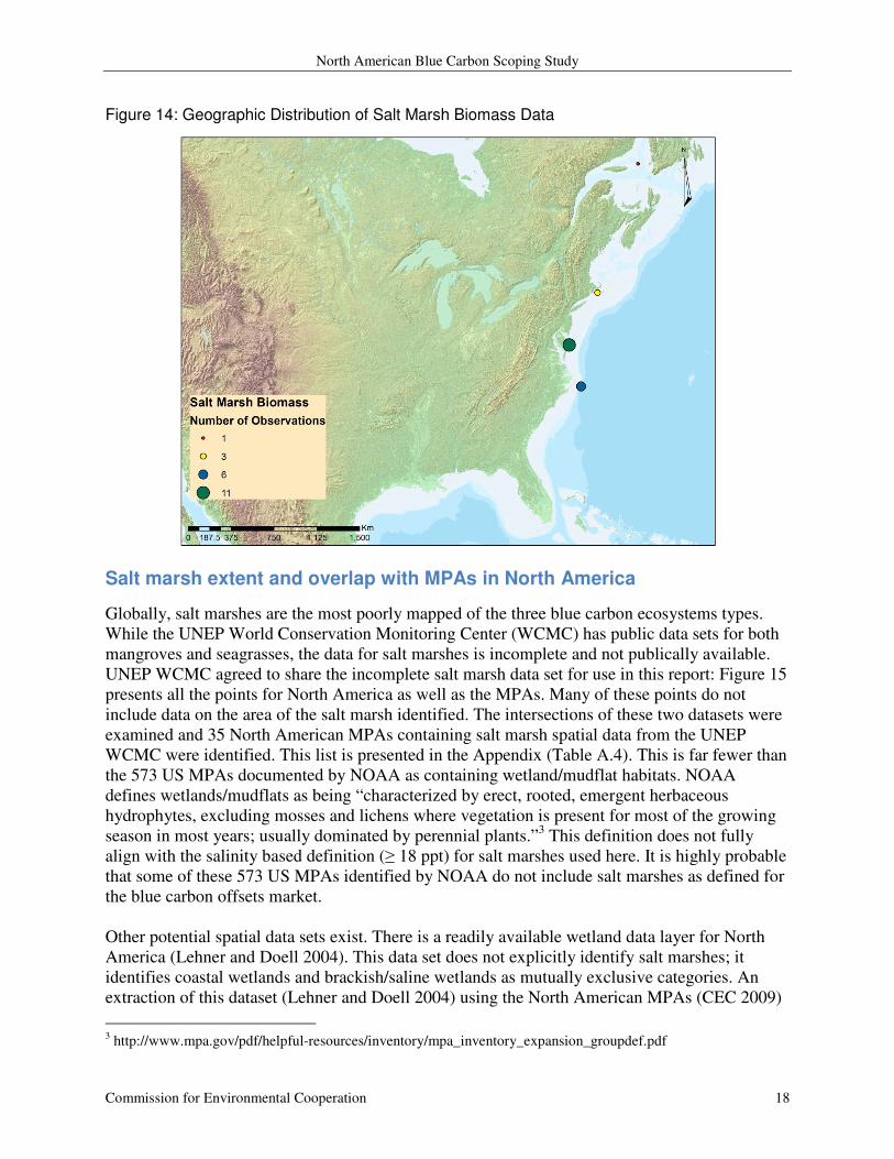
Figure 14: Geographic Distribution of Salt Marsh Biomass Data
Salt marsh extent and overlap with MPAs in North America
Globally, salt marshes are the most poorly mapped of the three blue carbon ecosystems types.
While the UNEP World Conservation Monitoring Center (WCMC) has public data sets for both
mangroves and seagrasses, the data for salt marshes is incomplete and not publically available.
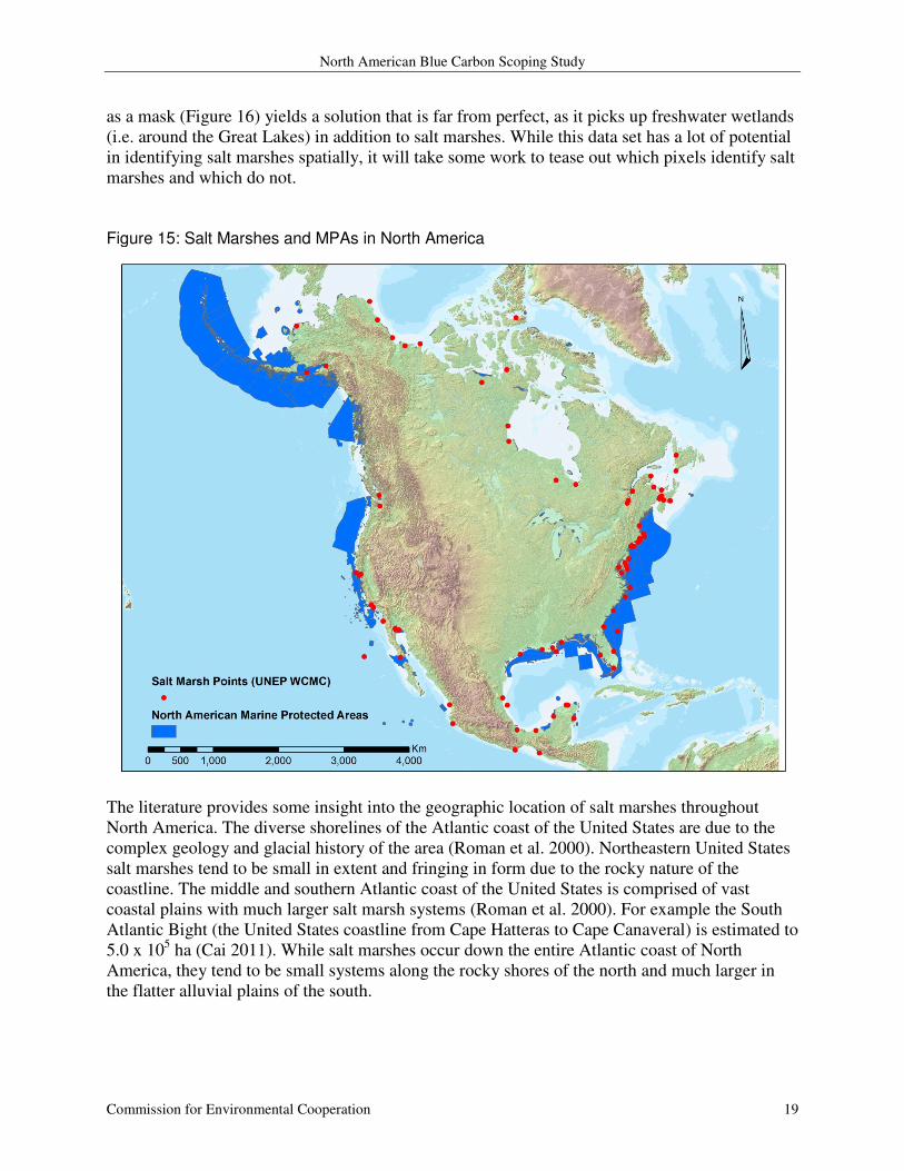
UNEP WCMC agreed to share the incomplete salt marsh data set for use in this report: Figure 15
presents all the points for North America as well as the MPAs. Many of these points do not
include data on the area of the salt marsh identified. The intersections of these two datasets were
examined and 35 North American MPAs containing salt marsh spatial data from the UNEP
WCMC were identified. This list is presented in the Appendix (Table A.4). This is far fewer than
the 573 US MPAs documented by NOAA as containing wetland/mudflat habitats. NOAA
defines wetlands/mudflats as being “characterized by erect, rooted, emergent herbaceous
hydrophytes, excluding mosses and lichens where vegetation is present for most of the growing
season in most years; usually dominated by perennial plants.”3 This definition does not fully
align with the salinity based definition (≥ 18 ppt) for salt marshes used here. It is highly probable
that some of these 573 US MPAs identified by NOAA do not include salt marshes as defined for
the blue carbon offsets market.
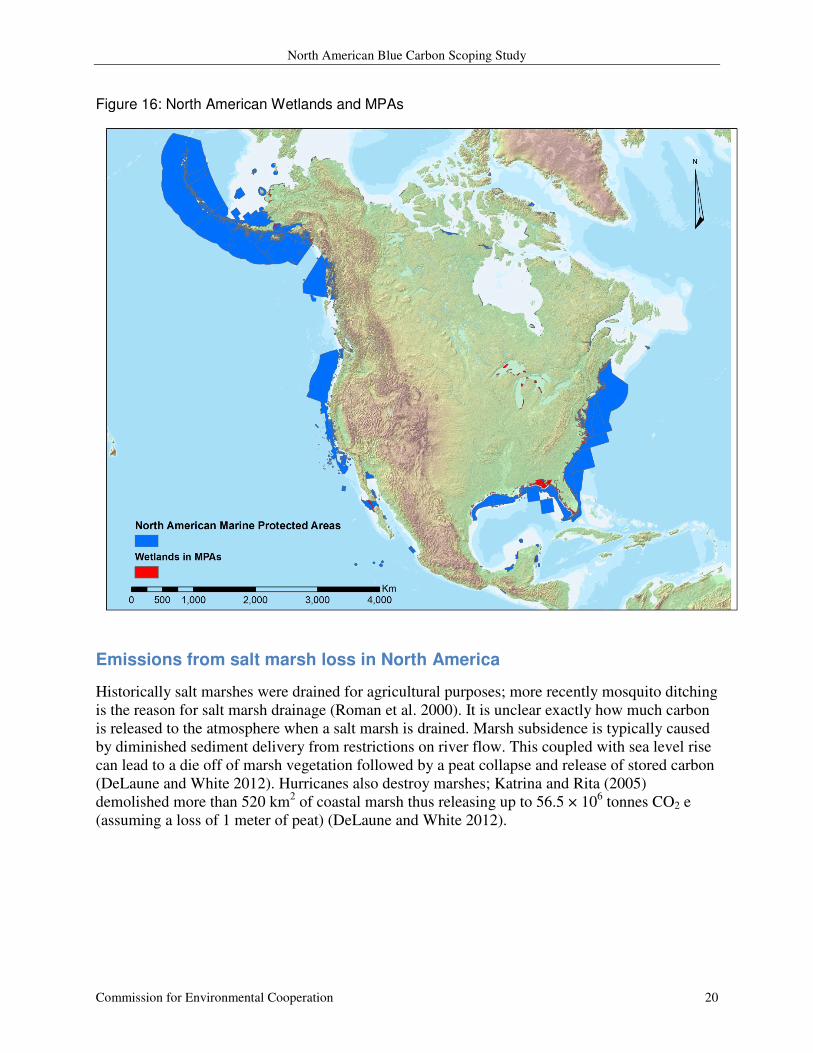
Other potential spatial data sets exist. There is a readily available wetland data layer for North
America (Lehner and Doell 2004). This data set does not explicitly identify salt marshes; it
identifies coastal wetlands and brackish/saline wetlands as mutually exclusive categories. An
extraction of this dataset (Lehner and Doell 2004) using the North American MPAs (CEC 2009)
3 http://www.mpa.gov/pdf/helpful-resources/inventory/mpa_inventory_expansion_groupdef.pdf
North American Blue Carbon Scoping Study
Commission for Environmental Cooperation 19
as a mask (Figure 16) yields a solution that is far from perfect, as it picks up freshwater wetlands
(i.e. around the Great Lakes) in addition to salt marshes. While this data set has a lot of potential
in identifying salt marshes spatially, it will take some work to tease out which pixels identify salt
marshes and which do not.
Figure 15: Salt Marshes and MPAs in North America
The literature provides some insight into the geographic location of salt marshes throughout
North America. The diverse shorelines of the Atlantic coast of the United States are due to the
complex geology and glacial history of the area (Roman et al. 2000). Northeastern United States
salt marshes tend to be small in extent and fringing in form due to the rocky nature of the
coastline. The middle and southern Atlantic coast of the United States is comprised of vast
coastal plains with much larger salt marsh systems (Roman et al. 2000). For example the South
Atlantic Bight (the United States coastline from Cape Hatteras to Cape Canaveral) is estimated to
5.0 x 10⁵ ha (Cai 2011). While salt marshes occur down the entire Atlantic coast of North
America, they tend to be small systems along the rocky shores of the north and much larger in
the flatter alluvial plains of the south.
North American Blue Carbon Scoping Study
Commission for Environmental Cooperation 20
Figure 16: North American Wetlands and MPAs
Emissions from salt marsh loss in North America
Historically salt marshes were drained for agricultural purposes; more recently mosquito ditching
is the reason for salt marsh drainage (Roman et al. 2000). It is unclear exactly how much carbon
is released to the atmosphere when a salt marsh is drained. Marsh subsidence is typically caused
by diminished sediment delivery from restrictions on river flow. This coupled with sea level rise
can lead to a die off of marsh vegetation followed by a peat collapse and release of stored carbon
(DeLaune and White 2012). Hurricanes also destroy marshes; Katrina and Rita (2005)
demolished more than 520 km2 of coastal marsh thus releasing up to 56.5 × 10
6 tonnes CO2 e
(assuming a loss of 1 meter of peat) (DeLaune and White 2012).
North American Blue Carbon Scoping Study
Commission for Environmental Cooperation 21
Seagrasses in North America
Seagrasses are unique among the blue carbon ecosystems in that they are a completely
submerged community comprised of underwater flowering plants. Seagrasses occur in low
energy coastal areas and provide important habitat for a variety of marine species. Seagrass
systems have low aboveground biomass and associated carbon when compared to other blue
carbon systems. Belowground, seagrasses have immense root structures that accrete vertically.
This matte of roots and sediment that develops beneath seagrass meadows can store large
quantities of sequestered carbon.
Annual carbon sequestration in seagrass meadows of North America
There are two major articles of note regarding the carbon sequestration rate of seagrass
meadows, namely Duarte and others (2010) as well as Fourqurean and others (2012). Duarte and
others (2010) review estimates of primary production and metabolism for seagrass communities
around the globe. This method allows for negative sequestration rates in situations where
community respiration exceeds production. A total of 221 estimates of net primary production
are available for North America (Duarte et al. 2010). Fourqurean and others (2012) review
published and unpublished sediment core data. This type of data has previously been unavailable
for seagrass systems. The work of Fourqurean and others (2012) provides bulk density
observations for many sediment samples that previously reported only percent organic carbon.
The dataset developed by Fourqurean and others (2012) is available to the public and includes
dates on 11 soil cores from North America, enabling the calculation of annual carbon
sequestration rates. An earlier review by Cebrian and others (2002) uses this same method and
presents 5 observations within North America.
A total of 226 observations of annual carbon sequestration rates are presented for North
America. These values range from -76.7 to 75.3 tonnes CO2 e ha-1
yr-1
with a mean of 5.06 (SD =
17.8) and a median of 2.5 (Figure 17). The bulk of these data were collected in Florida (Florida
Keys n = 91, Northwestern Florida n = 29) and Texas (n = 49) (Figure 18).

North American Blue Carbon Scoping Study
Commission for Environmental Cooperation 22
Figure 17: Distribution of Available Data on Seagrass Carbon Sequestration Rate in North America
Figure 18: Geographic Distribution of Seagrass Carbon Sequestration Rate Data
North American Blue Carbon Scoping Study
Commission for Environmental Cooperation 23
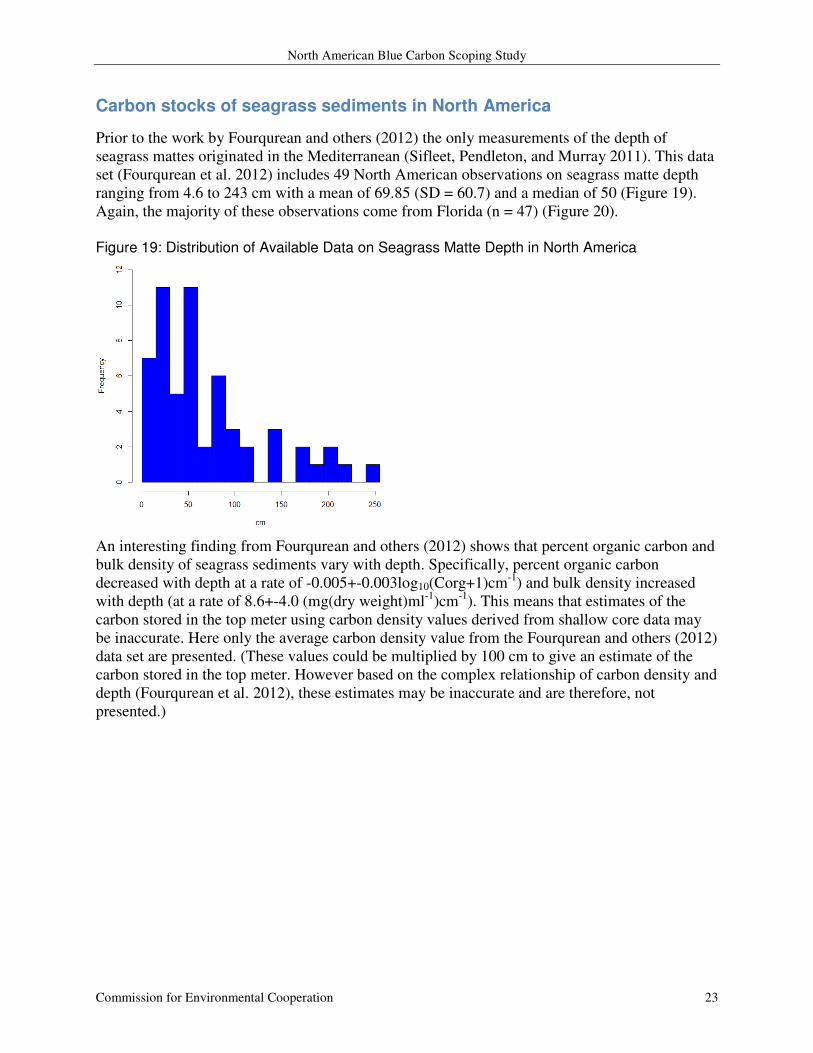
Carbon stocks of seagrass sediments in North America
Prior to the work by Fourqurean and others (2012) the only measurements of the depth of
seagrass mattes originated in the Mediterranean (Sifleet, Pendleton, and Murray 2011). This data
set (Fourqurean et al. 2012) includes 49 North American observations on seagrass matte depth
ranging from 4.6 to 243 cm with a mean of 69.85 (SD = 60.7) and a median of 50 (Figure 19).
Again, the majority of these observations come from Florida (n = 47) (Figure 20).
Figure 19: Distribution of Available Data on Seagrass Matte Depth in North America
An interesting finding from Fourqurean and others (2012) shows that percent organic carbon and
bulk density of seagrass sediments vary with depth. Specifically, percent organic carbon
decreased with depth at a rate of -0.005+-0.003log10(Corg+1)cm-1
) and bulk density increased
with depth (at a rate of 8.6+-4.0 (mg(dry weight)ml-1
)cm-1
). This means that estimates of the
carbon stored in the top meter using carbon density values derived from shallow core data may
be inaccurate. Here only the average carbon density value from the Fourqurean and others (2012)
data set are presented. (These values could be multiplied by 100 cm to give an estimate of the
carbon stored in the top meter. However based on the complex relationship of carbon density and
depth (Fourqurean et al. 2012), these estimates may be inaccurate and are therefore, not
presented.)

North American Blue Carbon Scoping Study
Commission for Environmental Cooperation 24
Figure 20: Geographic Distribution of Seagrass Matte Depth Data
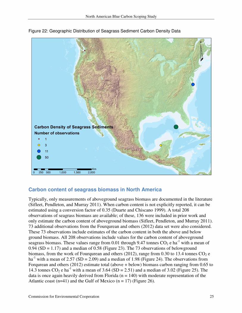
The Fourqurean and others (2012) data set includes 65 observations of carbon density from
North America ranging from 0.11 to 8.34 tonnes CO2 e ha-1
cm-1
with a mean of 3.34 (SD = 1.89)
and a median of 3.27 (Figure 21). The majority of these observations originate in Florida (n=50)
or Chesapeake Bay (n = 11) (Figure 22). Figure 21: Distribution of Available Data on Seagrass Sediment Carbon Density in North America
North American Blue Carbon Scoping Study
Commission for Environmental Cooperation 25
Figure 22: Geographic Distribution of Seagrass Sediment Carbon Density Data
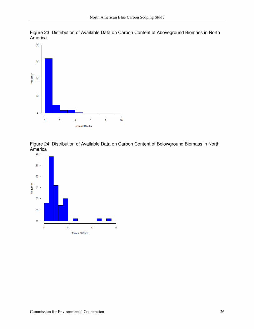
Carbon content of seagrass biomass in North America
Typically, only measurements of aboveground seagrass biomass are documented in the literature
(Sifleet, Pendleton, and Murray 2011). When carbon content is not explicitly reported, it can be
estimated using a conversion factor of 0.35 (Duarte and Chiscano 1999). A total 208
observations of seagrass biomass are available; of these, 136 were included in prior work and
only estimate the carbon content of aboveground biomass (Sifleet, Pendleton, and Murray 2011).
73 additional observations from the Fourqurean and others (2012) data set were also considered.
These 73 observations include estimates of the carbon content in both the above and below
ground biomass. All 208 observations include values for the carbon content of aboveground
seagrass biomass. These values range from 0.01 through 9.47 tonnes CO2 e ha-1
with a mean of
0.94 (SD = 1.17) and a median of 0.58 (Figure 23). The 73 observations of belowground
biomass, from the work of Fourqurean and others (2012), range from 0.30 to 13.4 tonnes CO2 e
ha-1
with a mean of 2.57 (SD = 2.09) and a median of 1.98 (Figure 24). The observations from
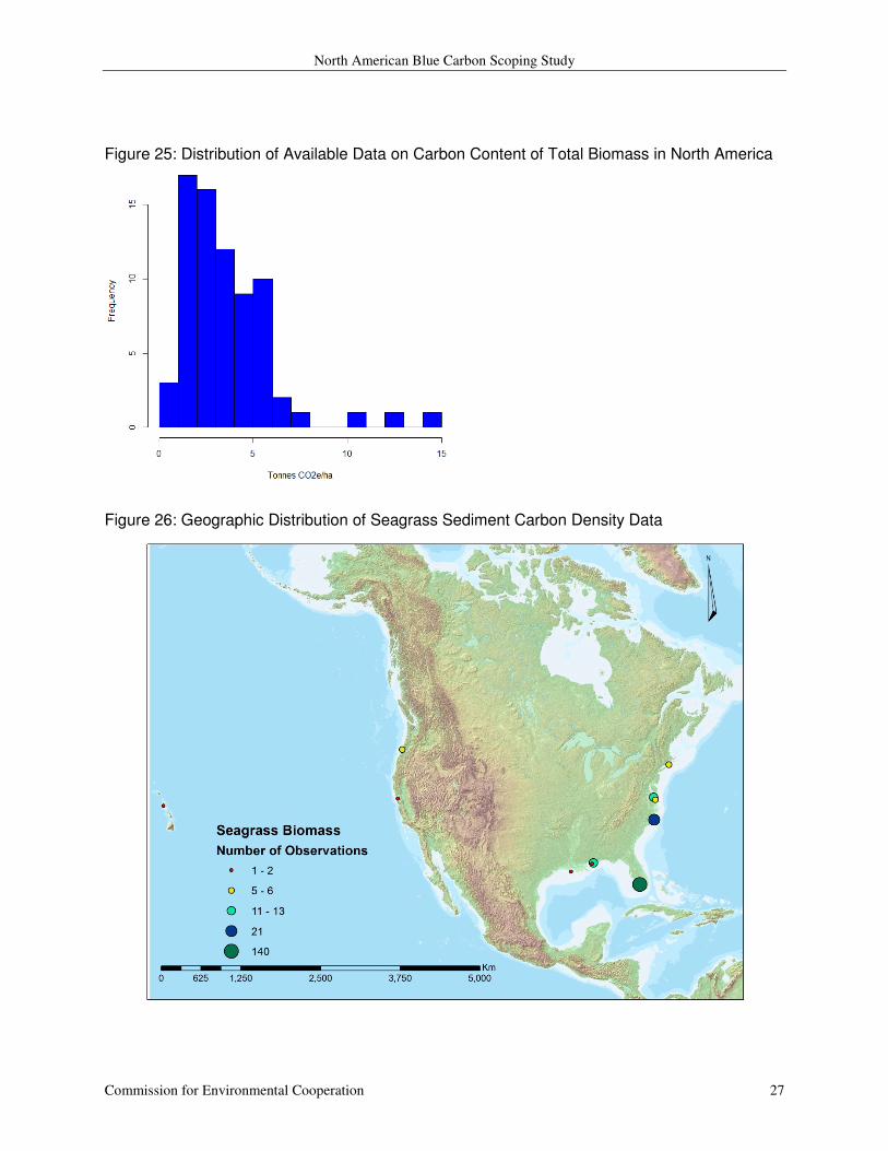
Forqurean and others (2012) estimate total (above + below) biomass carbon ranging from 0.65 to
14.3 tonnes CO2 e ha-1
with a mean of 3.64 (SD = 2.51) and a median of 3.02 (Figure 25). The
data is once again heavily derived from Florida (n = 140) with moderate representation of the
Atlantic coast (n=41) and the Gulf of Mexico (n = 17) (Figure 26).
North American Blue Carbon Scoping Study
Commission for Environmental Cooperation 26
Figure 23: Distribution of Available Data on Carbon Content of Aboveground Biomass in North America
Figure 24: Distribution of Available Data on Carbon Content of Belowground Biomass in North America
North American Blue Carbon Scoping Study
Commission for Environmental Cooperation 27
Figure 25: Distribution of Available Data on Carbon Content of Total Biomass in North America
Figure 26: Geographic Distribution of Seagrass Sediment Carbon Density Data

North American Blue Carbon Scoping Study
Commission for Environmental Cooperation 28
Seagrass extent and overlap with MPAs in North America
Seagrass ecosystems are relatively well mapped for the globe. The UNEP WCMC provides two
publically available geospatial data sets; one is a point data set (Short and Green 2005a) and the
other is a polygon data set (Short and Green 2005b). Both of these data sets are displayed with
the North American MPAs (CEC 2009) in Figure 27. These datasets were intersected to identify
which MPAs contain seagrass spatial data. 27 North American MPAs overlap with the UNEP
WCMC seagrass spatial data; they are listed in Table A.4 in the Appendix. This is far fewer than
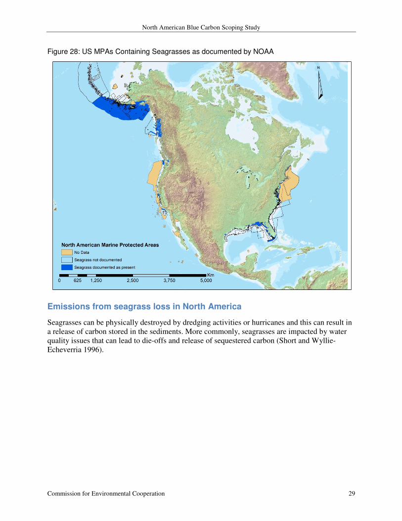
the 361 US MPAs documented as containing seagrass ecosystems by NOAA (Figure 28 and).
Figure 27: Seagrasses and MPAs in North America
North American Blue Carbon Scoping Study
Commission for Environmental Cooperation 29
Figure 28: US MPAs Containing Seagrasses as documented by NOAA
Emissions from seagrass loss in North America
Seagrasses can be physically destroyed by dredging activities or hurricanes and this can result in
a release of carbon stored in the sediments. More commonly, seagrasses are impacted by water
quality issues that can lead to die-offs and release of sequestered carbon (Short and Wyllie-
Echeverria 1996).
North American Blue Carbon Scoping Study
Commission for Environmental Cooperation 30
Key Data Gaps & Recommendations
The primary data gap identified through this work is a lack of accurate geospatial data for salt
marsh and seagrass ecosystems. The high-resolution global mangrove forest spatial dataset
developed by Giri and others (2011) should be a model for future mapping efforts involving salt
marshes and seagrasses. The logistics for mapping salt marshes using satellite imagery are
promising. Seagrasses may present difficulties to satellite mapping efforts, as they are submerged
systems. Augmentation with onsite sampling and visual inspections (via diver or camera) may be
required (Eyre and Maher 2011). MPAs that are potential candidates for carbon credits related to
blue carbon must have detailed spatial data identifying the location of blue carbon ecosystems
within their boundaries. These maps need to be regularly updated to account for potential losses
from hurricanes and other phenomena.
Measuring the amount of carbon stored in the peat sediments underlying blue carbon ecosystems
is not a simple task. The data presented here rely on many assumptions (i.e. a meter depth and
constant soil carbon density). We know that some of these simplifying assumptions are not true;
Fourqurean and others (2012) show that organic carbon and bulk density vary with depth for
seagrass system sediments. The question remains as to whether or not this is the case with salt
marsh and mangrove derived sediments as well. The depth of these sediment deposits can also
vary widely; in mangroves, they range from under 1 meter to over 5 meters (Sifleet, Pendleton,
and Murray 2011) and we have no observational data on this for North America. A concerted
effort to collect and analyze sediment cores from blue carbon habitats existing in MPAs in North
America would resolve these issues.
Water quality, specifically nutrient loading, can impact the GHG balance of salt marsh
ecosystems (Irvine et al. 2012; Deegan et al. 2012; Moseman-Valtierra et al. 2011). We also
know that nutrient loading can lead to seagrass die-offs (Short and Wyllie-Echeverria 1996).
Water quality monitoring of blue carbon habitats within MPAs can help inform the true amount
of carbon an ecosystem is storing.
North American Blue Carbon Scoping Study
Commission for Environmental Cooperation 31
Literature Cited
Agrawal, A., D. Nepstad, and A. Chhatre. 2011. Reducing emissions from deforestation and
forest degradation. Annual Review of Environment and Resources 36:373-396.
Alongi, D.M., F. Tirendi, P. Dixon, L.A. Trott, and G.J. Brunskill. 1999. Sources, sinks, and
export of organic carbon fluzes in adjacent tropical nearshore sediments. Marine
Ecological Progress Series 56:134-144.
Barr, Jordan G., Vic Engel, Thomas J. Smith, and Jose D. Fuentes. 2012. Hurricane disturbance
and recovery of energy balance, CO2 fluxes and canopy structure in a mangrove forest of
the Florida Everglades. Agricultural and Forest Meteorology 153.
Bouillion, S., A. V. Borges, E. Castaneda-Moya, K. Diele, T. Dittmar, N. C. Duke, E.
Kristensen, S. Y. Lee, C. Marchand, J. J. Middleburg, V. H. Rivera-Monroy, T. J. III
Smith, and R. R. Twilley. 2008. Mangrove production and carbon sinks: A revision of
global budget estimates. Global Biogeochemical Cycles 22:GB2013.
Bouillon, Steven, Alberto V. Borges, Edward Castaneda-Moya, Karen Diele, Thorsten Dittmar,
Norman C. Duke, Erik Kristensen, Shing Y. Lee, Cyril Marchand, Jack J. Middelburg,
Victor H. Rivera-Monroy, Thomas J. Smith, III, and Robert R. Twilley. 2008. Mangrove
production and carbon sinks: A revision of global budget estimates. Global
Biogeochemical Cycles 22 (2).
Breithaupt, Joshua L., Joseph M. Smoak, Thomas J. Smith, III, Christian J. Sanders, and
Armando Hoare. 2012. Organic carbon burial rates in mangrove sediments:
Strengthening the global budget. Global Biogeochemical Cycles 26.
Cai, Wei-Jun. 2011. Estuarine and Coastal Ocean Carbon Paradox: CO2 Sinks or Sites of
Terrestrial Carbon Incineration? In Annual Review of Marine Science, Vol 3, edited by C.
A. Carlson and S. J. Giovannoni.
Callaway, John C., Evyan L. Borgnis, R. Eugene Turner, and Charles S. Milan. 2012. Carbon
Sequestration and Sediment Accretion in San Francisco Bay Tidal Wetlands. Estuaries
and Coasts 35 (5).
Castaneda-Moya, Edward, Robert R. Twilley, Victor H. Rivera-Monroy, Brian D. Marx, Carlos
Coronado-Molina, and Sharon M. L. Ewe. 2011. Patterns of Root Dynamics in Mangrove
Forests Along Environmental Gradients in the Florida Coastal Everglades, USA.
Ecosystems 14 (7).
Cebrian, J. 2002. Variability and control of carbon consumption, export, and accumulation in
marine communities. Limnology and Oceanography 47 (1):11-22.
CEC. 2009. North american Marine Protected Areas NA_MPA_12_30_09. [cited 05/12/2012.
Available from http://www.cec.org/Page.asp?PageID=924&ContentID=2336.
Chmura, G. L., S. C. Anisfeld, D. R. Cahoon, and J. C. Lynch. 2003. Global carbon sequestration
in tidal, saline wetland soils. Global biogeochemical cycles 17 (4):1111.
Chmura, Gail L., Lisa Kellman, and Glenn R. Guntenspergen. 2011. The greenhouse gas flux
and potential global warming feedbacks of a northern macrotidal and microtidal salt
marsh. Environmental Research Letters 6 (4).
Craft, C. 2007. Freshwater input structures soil properties, vertical accretion, and nutrient
accumulation of Georgia and U.S. tidal marshes. Limnology and Oceanography 52
(3):1220-1230.
Deegan, Linda A., David Samuel Johnson, R. Scott Warren, Bruce J. Peterson, John W. Fleeger,
Sergio Fagherazzi, and Wilfred M. Wollheim. 2012. Coastal eutrophication as a driver of
salt marsh loss. Nature 490 (7420).

North American Blue Carbon Scoping Study
Commission for Environmental Cooperation 32
DeLaune, R. D., and J. R. White. 2012. Will coastal wetlands continue to sequester carbon in
response to an increase in global sea level?: a case study of the rapidly subsiding
Mississippi river deltaic plain. Climatic Change 110 (1-2).
Donato, D. C., J. B. Kauffman, R. A. Mackenzie, A. Ainsworth, and A. Z. Pfleeger. 2012.
Whole-island carbon stocks in the tropical Pacific: Implications for mangrove
conservation and upland restoration. Journal of Environmental Management 97.
Donato, Daniel C., J. Boone Kauffman, Daniel Murdiyarso, Sofyan Kurnianto, Melanie Stidham,
and Markku Kanninen. 2011. Mangroves among the most carbon-rich forests in the
tropics. Nature Geoscience 4 (5).
Duarte, C. M., and C. L. Chiscano. 1999. Seagrass biomass and production: a reassessment.
Aquatic Botany 65:159-174.
Duarte, C. M., N Marba, E. Gacia, J.W. Fourgurean, J. Beggins, C. Barron, and E.T. Apostolaki.
2010. Seagrass community metabolism: Assessing the carbon sink capacity of seagrass
meadows.
Elsey-Quirk, Tracy, Denise M. Seliskar, Christopher K. Sommerfield, and John L. Gallagher.
2011. Salt Marsh Carbon Pool Distribution in a Mid-Atlantic Lagoon, USA: Sea Level
Rise Implications. Wetlands 31 (1).
Eyre, Bradley D., and Damien Maher. 2011. Mapping ecosystem processes and function across
shallow seascapes. Continental Shelf Research 31 (2).
FAO. 2007. The World's Mangroves 1980-2005. Rome: Food and Agriculture Organization of
the United Nations.
Fourqurean, James W., Carlos M. Duarte, Hilary Kennedy, Nuria Marba, Marianne Holmer,
Miguel Angel Mateo, Eugenia T. Apostolaki, Gary A. Kendrick, Dorte Krause-Jensen,
Karen J. McGlathery, and Oscar Serrano. 2012. Seagrass ecosystems as a globally
significant carbon stock. Nature Geoscience 5 (7).
Giri, C., E. Ochieng, L. L. Tieszen, Z. Zhu, A. Singh, T. Loveland, J. Masek, and N. Duke. 2011.
Status and distribution of mangrove forests of the world using earth observation satellite
data. Global Ecology and Biogeography 20 (1):154-159.
Irvine, Irina C., Lucia Vivanco, Peris N. Bentley, and Jennifer B. H. Martiny. 2012. The effect of
nitrogen enrichment on c(1)-cycling microorganisms and methane flux in salt marsh
sediments. Frontiers in microbiology 3.
Kathilankal, James C., Thomas J. Mozdzer, Jose D. Fuentes, Paolo D'Odorico, Karen J.
McGlathery, and Jay C. Zieman. 2008. Tidal influences on carbon assimilation by a salt
marsh. Environmental Research Letters 3 (4).
Kennedy, H., J. Beggins, C. M. Duarte, J. W. Fourqurean, M. Holmer, N. Marbà, and J. J.
Middelburg. 2010. Seagrass sediments as a global carbon sink: Isotopic constraints.
Kirwan, M. L., and L. K. Blum. 2011. Enhanced decomposition offsets enhanced productivity
and soil carbon accumulation in coastal wetlands responding to climate change.
Biogeosciences 8 (4).
Kirwan, Matthew L., and Simon M. Mudd. 2012. Response of salt-marsh carbon accumulation to
climate change. Nature 489 (7417).
Komiyama, Akira, Jin Eong Ong, and Sasitorn Poungparn. 2008. Allometry, biomass, and
productivity of mangrove forests: A review. Aquatic Botany 89 (2).
Kristensen, Erik, Steven Bouillon, Thorsten Dittmar, and Cyril Marchand. 2008. Organic carbon
dynamics in mangrove ecosystems: A review. Aquatic Botany 89 (2).
North American Blue Carbon Scoping Study
Commission for Environmental Cooperation 33
Kuenzer, C., A. Bluemel, S. Gebhardt, T. V. Quoc, and S. Dech. 2011. Remote sensing of
mangrove ecosystems: A review. Remote Sensing 3 (5):878-928.
Laffoley, D. d’A., and G. Grimsditch. 2009. The management of natural coastal carbon sinks.
edited by D. d. A. Laffoley and G. Grimsditch. Gland Switzerland: IUCN.
Lehner, B., and P. Doell. 2004. Development and validation of a global database of lakes,
reservoirs and wetlands. Journal of Hydrology 296 (1 - 4):1 - 22.
Livesley, Stephen J., and Sascha M. Andrusiak. 2012. Temperate mangrove and salt marsh
sediments are a small methane and nitrous oxide source but important carbon store.
Estuarine Coastal and Shelf Science 97.
Loomis, M.J., and C. Craft. 2010. Carbon sequestration adn nutrient (Nitrogen, Phosphorus)
accumulation in river-dominated tidal marshes, Georgia, USA. Wetland Soils 74
(3):1028-1036.
Lovelock, Catherine E., Roger W. Ruess, and Ilka C. Feller. 2011. CO2 efflux from cleared
mangrove peat. PloS one 6 (6).
Madrid, Eric N., Antonietta Quigg, and Anna R. Armitage. 2012. Marsh construction techniques
influence net plant carbon capture by emergent and submerged vegetation in a brackish
marsh in the northwestern Gulf of Mexico. Ecological Engineering 42.
Moseman-Valtierra, Serena, Rosalinda Gonzalez, Kevin D. Kroeger, Jianwu Tang, Wei Chun
Chao, John Crusius, John Bratton, Adrian Green, and James Shelton. 2011. Short-term
nitrogen additions can shift a coastal wetland from a sink to a source of N2O.
Atmospheric Environment 45 (26).
Mudd, Simon M., Susan M. Howell, and James T. Morris. 2009. Impact of dynamic feedbacks
between sedimentation, sea-level rise, and biomass production on near-surface marsh
stratigraphy and carbon accumulation. Estuarine Coastal and Shelf Science 82 (3).
Murray, B.C., L. Pendleton, W.A. Jenkins, and S.D. Sifleet. 2011. Green payments for Blue
Carbon: Economic incentives for Protecting Threatened Coastal Habitats. Durham, NC:
Nicholas Institute for Environmental Policy Solutions.
Nellemann, C., E. Corcoran, C. M. Duarte, L. Valdes, C. De Young, L. Fonseca, and G.
Grimsditch. 2009. Blue Carbon. A Rapid Response Assessment. United Nations
Environment Programme.
Osborne, Todd Z., Gregory L. Bruland, Susan Newman, K. Ramesh Reddy, and Sabine
Grunwald. 2011. Spatial distributions and eco-partitioning of soil biogeochemical
properties in the Everglades National Park. Environmental Monitoring and Assessment
183 (1-4).
Osland, Michael J., Amanda C. Spivak, Janet A. Nestlerode, Jeannine M. Lessmann, Alejandro
E. Almario, Paul T. Heitmuller, Marc J. Russell, Ken W. Krauss, Federico Alvarez,
Darrin D. Dantin, James E. Harvey, Andrew S. From, Nicole Cormier, and Camille L.
Stagg. 2012. Ecosystem Development After Mangrove Wetland Creation: Plant-Soil
Change Across a 20-Year Chronosequence. Ecosystems 15 (5).
Pendleton, Linwood, Daniel C. Donato, Brian C. Murray, Stephen Crooks, W. Aaron Jenkins,
Samantha Sifleet, Christopher Craft, James W. Fourqurean, J. Boone Kauffman, Nuria
Marba, Patrick Megonigal, Emily Pidgeon, Dorothee Herr, David Gordon, and Alexis
Baldera. 2012. Estimating Global "Blue Carbon" Emissions from Conversion and
Degradation of Vegetated Coastal Ecosystems. Plos One 7 (9).
Poffenbarger, Hanna J., Brian A. Needelman, and J. Patrick Megonigal. 2011. Salinity Influence
on Methane Emissions from Tidal Marshes. Wetlands 31 (5).
North American Blue Carbon Scoping Study
Commission for Environmental Cooperation 34
Roman, C. T., N. Jaworski, F. T. Short, S. Findlay, and R. S. Warren. 2000. Estuaries of the
northeastern United States: habitat and land use signatures. Estuaries and Coasts 23
(6):743-764.
Sanchez-Carrillo, S., R. Sanchez-Andres, L. C. Alatorre, D. G. Angeler, M. Alvarez-Cobelas,
and J. A. Arreola-Lizarraga. 2009. Nutrient fluxes in a semi-arid microtidal mangrove
wetland in the Gulf of California. Estuarine Coastal and Shelf Science 82 (4).
Short, F. T., and S. Wyllie-Echeverria. 1996. Natural and human-induced disturbance of
seagrasses. Environmental Conservation 23 (1):17-27.
Short, F.T., and E.P. Green. 2005a. Global Distribution of Seagrasses – Points Dataset.
Short, F.T., and E.P. Green. 2005b. Global Distribution of Seagrasses – Polygons Dataset.
Sifleet, S.D., L. Pendleton, and B.C. Murray. 2011. State of the science on coastal blue carbon: A
summary for policy makers. Duke Nicholas Institute for Environmental Policy Solutions.
Siikamaki, Juha, James N. Sanchirico, and Sunny L. Jardine. 2012. Global economic potential
for reducing carbon dioxide emissions from mangrove loss. Proceedings of the National
Academy of Sciences of the United States of America 109 (36).
Solomon, S., D. Qin, M. Manning, R.B. Alley, T. Berntsen, N.L. Bindoff, Z. Chen, A.
Chidthaisong, J.M. Gregory, G.C. Hegerl, M. Heimann, B. Hewitson, B.J. Hoskins, F.
Joos, J. Jouzel, V. Kattsov, U. Lohmann, T. Matsuno, M. Molina, N. Nicholls, J.
Overpeck, G. Raga, V. Ramaswamy, J. Ren, M. Rusticucci, R. Somerville, T.F. Stocker,
P. Whetton, R.A. Wood, and D. Wratt. 2007. 2007: Technical Summary. In Climate
Change 2007: The Physical Science Basis. Contribution of Working Group I to the
Fourth Assessment Report of the Intergovernmental Panel on Climate Change, edited by
S. Solomon, D. Qin, M. Manning, Z. Chen, M. Marquis, K. B. Averyt, M. Tignor and H.
L. Miller. Cambridge, United Kingdom and New York, NY USA: Cambridge University
Press.
VCS 2012. Wetland Restoration and Conservation published by the Verified Carbon Standard
2012 [cited 13/12/2012.
Available from http://v-c-s.org/wetlands_restoration_conservation.
Sweetman, A. K., J. J. Middelburg, A. M. Berle, A. F. Bernardino, C. Schander, A. W. J.
Demopoulos, and C. R. Smith. 2010. Impacts of exotic mangrove forests and mangrove
deforestation on carbon remineralization and ecosystem functioning in marine sediments.
Biogeosciences 7 (7).
Twilley, R. R., R. H. Chen, and T. Hargis. 1992. Carbon sinks in mangroves and their
implications to carbon budget of tropical coastal ecosystems. Water, Air, & Soil Pollution
64 (1):265-288.
Van der Werf, G. R., D. C. Morton, R. S. DeFries, J. G. J. Olivier, P. S. Kasibhatla, R. B.
Jackson, G. J. Collatz, and J. T. Randerson. 2009. CO2 emissions from forest loss.
Nature Geoscience 2 (11):737-738.
North American Blue Carbon Scoping Study
Commission for Environmental Cooperation 35
Appendix: Additional Tables and Figures
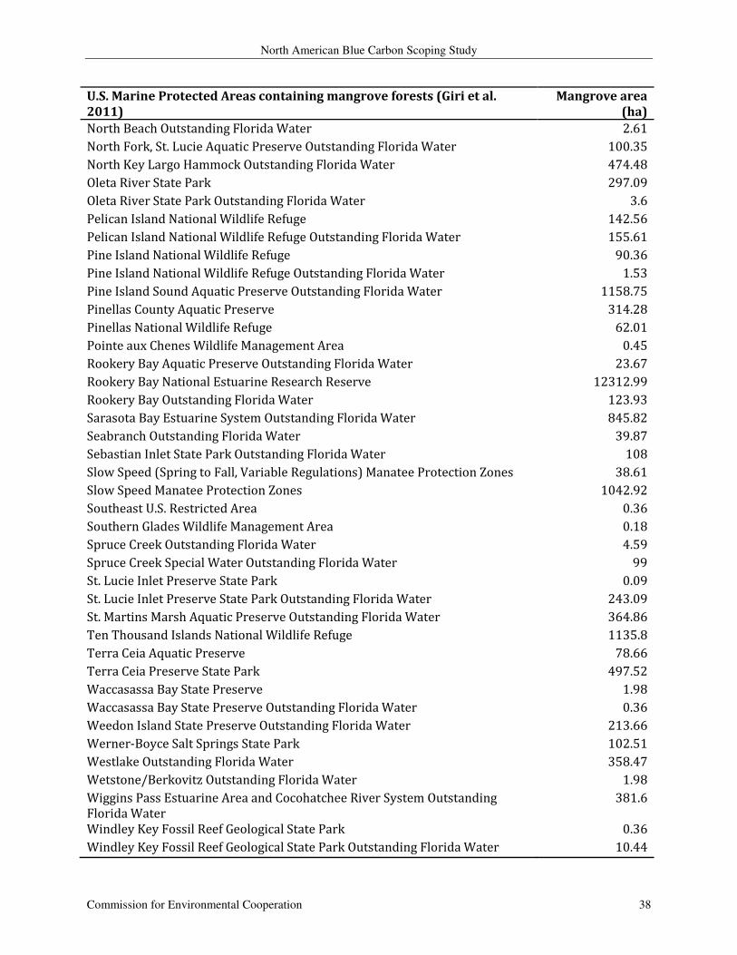
Table A.1: US MPAs Overlapping with Mangrove Ecosystems (Giri et al. 2011)
U.S. Marine Protected Areas containing mangrove forests (Giri et al.
2011)
Mangrove area
(ha)
Anclote Key State Park 10.08
Anclote Key State Preserve Outstanding Florida Water 81.72
Atchafalaya Delta Wildlife Management Area and Game Preserve 324.9
Avalon State Park 88.11
Avalon State Park Outstanding Florida Water 14.49
Bahia Honda State Park 65.25
Bahia Honda State Park Outstanding Florida Water 3.06
Banana River Aquatic Preserve Outstanding Florida Water 45
Barefoot Beach Outstanding Florida Water 1.89
Big Bend Seagrasses Aquatic Preserve 3.69
Biscayne Bay Aquatic Preserve 432.09
Biscayne National Park 2360.25
Biscayne National Park Outstanding Florida Water 0.54
Boca Ciega Bay Aquatic Preserve Outstanding Florida Water 78.66
Bower Tract Outstanding Florida Water 352.8
Breton National Wildlife Refuge 110.97
Caladesi Island State Park 0.81
Caladesi Island State Park Outstanding Florida Water 143.73
Caloosahatchee National Wildlife Refuge Outstanding Florida Water 4.86
Canaveral National Seashore 15.21
Canaveral National Seashore Outstanding Florida Water 19.98
Cape Haze Aquatic Preserve Outstanding Florida Water 417.42
Cape Romano - Ten Thousand Islands Aquatic Preserve 4214.16
Cayo Costa State Park 34.02
Cayo Costa State Park Outstanding Florida Water 280.98
Cedar Keys National Wildlife Refuge 8.19
Charlotte Harbor Preserve State Park 10712.34
Chassahowitzka National Wildlife Refuge 25.47
Chassahowitzka National Wildlife Refuge Outstanding Florida Water 0.54
Cockroach Bay Aquatic Preserve 150.57
Cockroach Bay Preserve State Park 90
Collier-Seminole State Park Outstanding Florida Water 530.64
Coupon Bight Aquatic Preserve Outstanding Florida Water 37.71
Coupon Bight Outstanding Florida Water 375.39
Crocodile Lake National Wildlife Refuge 468.27
Crocodile Lake National Wildlife Refuge Outstanding Florida Water 2424.06
North American Blue Carbon Scoping Study
Commission for Environmental Cooperation 36
U.S. Marine Protected Areas containing mangrove forests (Giri et al.
2011)
Mangrove area
(ha)
Crystal River Preserve State Park 0.27
Curry Hammock Outstanding Florida Water 10.53
Curry Hammock State Park 227.7
Delnor-Wiggins Pass State Recreation Area 0.27
Delta National Wildlife Refuge 0.18
Don Pedro Island State Park 5.49
Don Pedro Island State Park Outstanding Florida Water 0.09
East Everglades Outstanding Florida Water 13.77
Emerson Point Outstanding Florida Water 59.76
Estero Bay Aquatic Preserve 24.21
Estero Bay Outstanding Florida Water 3749.49
Estero Bay Preserve State Park 156.15
Estero Bay Tributaries Outstanding Florida Water 128.07
Everglades National Park 99.72
Everglades National Park Outstanding Florida Water 119851.29
Fakahatchee Strand State Preserve 2459.97
Florida Keys National Marine Sanctuary 741.78
Florida Keys Outstanding Florida Water 437.76
Florida Keys Wildlife and Environmental Area 565.29
Fort Pierce Inlet State Recreation Area 267.57
Fort Pierce Inlet State Recreation Area Outstanding Florida Water 7.92
Fort Zachary Taylor State Historic Site 2.61
Fort Zachary Taylor State Historic Site Outstanding Florida Water 0.45
Gasparilla Island State Park 1.17
Gasparilla Island State Park Outstanding Florida Water 7.74
Gasparilla Sound - Charlotte Harbor Aquatic Preserve 841.14
Gills Tract Outstanding Florida Water 0.72
Great White Heron National Wildlife Refuge 3.06
Great White Heron National Wildlife Refuge Outstanding Florida Water 1856.25
Hobe Sound National Wildlife Refuge Outstanding Florida Water 67.41
Honeymoon Island State Recreation Area 30.6
Idle Speed (Fall to Spring) Manatee Protection Zones 1.8
Idle Speed Manatee Protection Zones 22.23
Indian Key State Historic Site 4.05
Indian Key State Historic Site Outstanding Florida Water 0.72
Indian River - Malabar to Vero Beach Aquatic Preserve 1.53
Indian River - Malabar to Vero Beach Aquatic Preserve Outstanding Florida
Water
305.91
Indian River - Vero Beach to Ft. Pierce Aquatic Preserve 189.72
Indian River Lagoon Preserve State Park 40.59
Isles Dernieres Barrier Islands Refuge 10.17
North American Blue Carbon Scoping Study
Commission for Environmental Cooperation 37
U.S. Marine Protected Areas containing mangrove forests (Giri et al.
2011)
Mangrove area
(ha)
J.N. Ding Darling National Wildlife Refuge 1466.91
J.N. Ding Darling National Wildlife Refuge/Sanibel Conservation Zone 12.33
Jensen Beach to Jupiter Inlet Aquatic Preserve Outstanding Florida Water 179.64
John D. MacArthur Beach State Park 47.97
John D. McArthur Beach State Park Outstanding Florida Water 0.09
John Pennekamp Coral Reef State Park 1502.82
John Pennekamp Coral Reef State Park Outstanding Florida Water 31.68
John U. Lloyd Beach State Park 45
John U. Lloyd Beach State Park Outstanding Florida Water 0.36
Jonathan Dickinson State Park 105.39
Jonathan Dickinson State Park Outstanding Florida Water 1.44
Key Largo Hammock State Botanical Site 1028.07
Key Largo Hammock State Botanical Site Outstanding Florida Water 16.83
Key West National Wildlife Refuge 29.34
Key West National Wildlife Refuge Outstanding Florida Water 1157.67
Lemon Bay Aquatic Preserve 2.97
Lemon Bay Estuarine System Outstanding Florida Water 341.82
Lignumvitae Key Aquatic Preserve Outstanding Florida Water 0.9
Lignumvitae Key Botanical State Park 278.91
Lignumvitae Key Botanical State Park Outstanding Florida Water 2.34
Little Manatee River Outstanding Florida Water 100.53
Long Key State Recreation Area 274.23
Lovers Key State Recreation Area 42.39
Lovers Key State Recreation Area Outstanding Florida Water 0.9
Loxahatchee River-Lake Worth Creek Aquatic Preserve Outstanding Florida
Water
27.72
Madira Bickel Mound State Archaeological Site 0.9
Martin County Tracts Outstanding Florida Water 0.81
Matlacha Pass Aquatic Preserve 928.71
Matlacha Pass National Wildlife Refuge 88.65
Matlacha Pass National Wildlife Refuge Outstanding Florida Water 4.59
Maximum 25 MPH Manatee Protection Zones 109.35
Maximum 25 MPH/ Slow Speed Buffer Manatee Protection Zones 8.37
Maximum 30 MPH in Channel/Slow Speed or 20 MPH Outside Channel
Manatee Protection Zones
117.27
Merritt Island National Wildlife Refuge 0.54
Merritt Island National Wildlife Refuge Outstanding Florida Water 15.75
Mission-Aransas National Estuarine Research Reserve 668.52
Mosquito Lagoon Aquatic Preserve Outstanding Florida Water 39.42
Myakka River Outstanding Florida Water 5.67
National Key Deer Refuge 6169.5
North American Blue Carbon Scoping Study
Commission for Environmental Cooperation 38
U.S. Marine Protected Areas containing mangrove forests (Giri et al.
2011)
Mangrove area
(ha)
North Beach Outstanding Florida Water 2.61
North Fork, St. Lucie Aquatic Preserve Outstanding Florida Water 100.35
North Key Largo Hammock Outstanding Florida Water 474.48
Oleta River State Park 297.09
Oleta River State Park Outstanding Florida Water 3.6
Pelican Island National Wildlife Refuge 142.56
Pelican Island National Wildlife Refuge Outstanding Florida Water 155.61
Pine Island National Wildlife Refuge 90.36
Pine Island National Wildlife Refuge Outstanding Florida Water 1.53
Pine Island Sound Aquatic Preserve Outstanding Florida Water 1158.75
Pinellas County Aquatic Preserve 314.28
Pinellas National Wildlife Refuge 62.01
Pointe aux Chenes Wildlife Management Area 0.45
Rookery Bay Aquatic Preserve Outstanding Florida Water 23.67
Rookery Bay National Estuarine Research Reserve 12312.99
Rookery Bay Outstanding Florida Water 123.93
Sarasota Bay Estuarine System Outstanding Florida Water 845.82
Seabranch Outstanding Florida Water 39.87
Sebastian Inlet State Park Outstanding Florida Water 108
Slow Speed (Spring to Fall, Variable Regulations) Manatee Protection Zones 38.61
Slow Speed Manatee Protection Zones 1042.92
Southeast U.S. Restricted Area 0.36
Southern Glades Wildlife Management Area 0.18
Spruce Creek Outstanding Florida Water 4.59
Spruce Creek Special Water Outstanding Florida Water 99
St. Lucie Inlet Preserve State Park 0.09
St. Lucie Inlet Preserve State Park Outstanding Florida Water 243.09
St. Martins Marsh Aquatic Preserve Outstanding Florida Water 364.86
Ten Thousand Islands National Wildlife Refuge 1135.8
Terra Ceia Aquatic Preserve 78.66
Terra Ceia Preserve State Park 497.52
Waccasassa Bay State Preserve 1.98
Waccasassa Bay State Preserve Outstanding Florida Water 0.36
Weedon Island State Preserve Outstanding Florida Water 213.66
Werner-Boyce Salt Springs State Park 102.51
Westlake Outstanding Florida Water 358.47
Wetstone/Berkovitz Outstanding Florida Water 1.98
Wiggins Pass Estuarine Area and Cocohatchee River System Outstanding
Florida Water
381.6
Windley Key Fossil Reef Geological State Park 0.36
Windley Key Fossil Reef Geological State Park Outstanding Florida Water 10.44

North American Blue Carbon Scoping Study
Commission for Environmental Cooperation 39
Table A.2: Mexican MPAs Overlapping with Mangrove Ecosystems (Giri et al. 2011)
Mexican Marine Protected Areas containing mangrove forests
(Giri et al. 2011)
Mangrove Area (ha)
BAHIA DE LOS ANGELES, CANAL DE BALLENAS Y SALSIPUEDES 113.13
ISLAS DEL GOLFO DE CALIFORNIA 74.97
ARCHIPIELAGO DE SAN LORENZO 0.54
EL VIZCAINO 20628.36
ZONA MARINA DEL ARCHIPIELAGO DE ESPIRITU SANTO 1.35
ISLAS MARIAS 99.72
YUM BALAM 6447.51
ISLA CONTOY 27.72
COSTA OCC. DE I MUJERES, PTA CANCUN Y PTA NIZUC 1.26
ARRECIFE DE PUERTO MORELOS 1.53
RIA CELESTUN 19423.53
LOS PETENES 41791.68
ARRECIFES DE COZUMEL 4.68
SIAN KAAN 6935.22
LAGUNA DE TERMINOS 106993.35
ARRECIFES DE XCALAK 1383.03
HUATULCO 92.61
LA ENCRUCIJADA 32325.12
Table A.3: U.S. MPAs containing mangrove forests as documented by NOAA4
U.S. MPAs containing mangrove forests as documented by NOAA
Anastasia State Park
Anastasia State Park Outstanding Florida Water
Anclote Key State Park
Anclote Key State Preserve Outstanding Florida Water
Archie Carr National Wildlife Refuge Outstanding Florida Water
Avalon State Park
Avalon State Park Outstanding Florida Water
4 Tabular data received via personal communication on 14/12/2012 with Jordan Glass, GIS Specialist for the
Pacific Regional Ocean Uses Atlas Project and National Marine Protected Areas Center
99 Pacific St. Suite 100F Monterey, CA 93940 [email protected] (831) 647-6464
http://www.mpa.gov

North American Blue Carbon Scoping Study
Commission for Environmental Cooperation 40
U.S. MPAs containing mangrove forests as documented by NOAA
Bahia Honda State Park
Bahia Honda State Park Outstanding Florida Water
Banana River Aquatic Preserve
Banana River Aquatic Preserve Outstanding Florida Water
Barefoot Beach Outstanding Florida Water
Bill Baggs Cape Florida State Park
Bill Baggs Cape Florida State Park Outstanding Florida Water
Biscayne Bay Aquatic Preserve
Biscayne Bay Aquatic Preserve Outstanding Florida Water
Biscayne National Park
Biscayne National Park Outstanding Florida Water
Biscayne National Park, Sponge Harvest Prohibited Area
Boca Ciega Bay Aquatic Preserve
Boca Ciega Bay Aquatic Preserve Outstanding Florida Water
Bower Tract Outstanding Florida Water
Caladesi Island State Park
Caladesi Island State Park Outstanding Florida Water
Caloosahatchee National Wildlife Refuge Outstanding Florida Water
Cape Haze Aquatic Preserve
Cape Haze Aquatic Preserve Outstanding Florida Water
Cayo Costa State Park
Cayo Costa State Park Outstanding Florida Water
Charlotte Harbor Preserve State Park
Charlotte Harbor State Reserve Outstanding Florida Water
Cockroach Bay Aquatic Preserve
Cockroach Bay Aquatic Preserve Outstanding Florida Water
Cockroach Bay Preserve State Park
Collier-Seminole State Park
Collier-Seminole State Park Outstanding Florida Water
Coupon Bight Aquatic Preserve
Coupon Bight Aquatic Preserve Outstanding Florida Water
Coupon Bight Outstanding Florida Water
Crystal River, including Kings Bay Outstanding Florida Water
Curry Hammock Outstanding Florida Water
Curry Hammock State Park
Delnor-Wiggins Pass State Recreation Area Outstanding Florida Water
Don Pedro Island State Park
Don Pedro Island State Park Outstanding Florida Water
Estero Bay Aquatic Preserve
Estero Bay Aquatic Preserve Outstanding Florida Water
Estero Bay Outstanding Florida Water
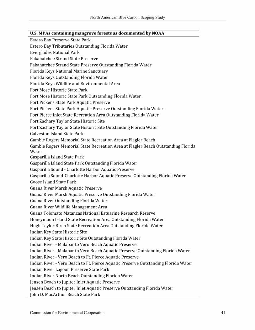
North American Blue Carbon Scoping Study
Commission for Environmental Cooperation 41
U.S. MPAs containing mangrove forests as documented by NOAA
Estero Bay Preserve State Park
Estero Bay Tributaries Outstanding Florida Water
Everglades National Park
Fakahatchee Strand State Preserve
Fakahatchee Strand State Preserve Outstanding Florida Water
Florida Keys National Marine Sanctuary
Florida Keys Outstanding Florida Water
Florida Keys Wildlife and Environmental Area
Fort Mose Historic State Park
Fort Mose Historic State Park Outstanding Florida Water
Fort Pickens State Park Aquatic Preserve
Fort Pickens State Park Aquatic Preserve Outstanding Florida Water
Fort Pierce Inlet State Recreation Area Outstanding Florida Water
Fort Zachary Taylor State Historic Site
Fort Zachary Taylor State Historic Site Outstanding Florida Water
Galveston Island State Park
Gamble Rogers Memorial State Recreation Area at Flagler Beach
Gamble Rogers Memorial State Recreation Area at Flagler Beach Outstanding Florida
Water
Gasparilla Island State Park
Gasparilla Island State Park Outstanding Florida Water
Gasparilla Sound - Charlotte Harbor Aquatic Preserve
Gasparilla Sound-Charlotte Harbor Aquatic Preserve Outstanding Florida Water
Goose Island State Park
Guana River Marsh Aquatic Preserve
Guana River Marsh Aquatic Preserve Outstanding Florida Water
Guana River Outstanding Florida Water
Guana River Wildlife Management Area
Guana Tolomato Matanzas National Estuarine Research Reserve
Honeymoon Island State Recreation Area Outstanding Florida Water
Hugh Taylor Birch State Recreation Area Outstanding Florida Water
Indian Key State Historic Site
Indian Key State Historic Site Outstanding Florida Water
Indian River - Malabar to Vero Beach Aquatic Preserve
Indian River - Malabar to Vero Beach Aquatic Preserve Outstanding Florida Water
Indian River - Vero Beach to Ft. Pierce Aquatic Preserve
Indian River - Vero Beach to Ft. Pierce Aquatic Preserve Outstanding Florida Water
Indian River Lagoon Preserve State Park
Indian River North Beach Outstanding Florida Water
Jensen Beach to Jupiter Inlet Aquatic Preserve
Jensen Beach to Jupiter Inlet Aquatic Preserve Outstanding Florida Water
John D. MacArthur Beach State Park
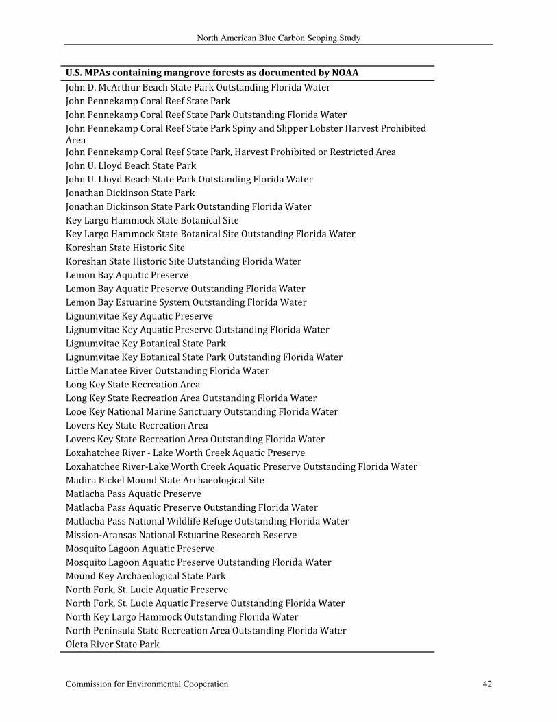
North American Blue Carbon Scoping Study
Commission for Environmental Cooperation 42
U.S. MPAs containing mangrove forests as documented by NOAA
John D. McArthur Beach State Park Outstanding Florida Water
John Pennekamp Coral Reef State Park
John Pennekamp Coral Reef State Park Outstanding Florida Water
John Pennekamp Coral Reef State Park Spiny and Slipper Lobster Harvest Prohibited
Area
John Pennekamp Coral Reef State Park, Harvest Prohibited or Restricted Area
John U. Lloyd Beach State Park
John U. Lloyd Beach State Park Outstanding Florida Water
Jonathan Dickinson State Park
Jonathan Dickinson State Park Outstanding Florida Water
Key Largo Hammock State Botanical Site
Key Largo Hammock State Botanical Site Outstanding Florida Water
Koreshan State Historic Site
Koreshan State Historic Site Outstanding Florida Water
Lemon Bay Aquatic Preserve
Lemon Bay Aquatic Preserve Outstanding Florida Water
Lemon Bay Estuarine System Outstanding Florida Water
Lignumvitae Key Aquatic Preserve
Lignumvitae Key Aquatic Preserve Outstanding Florida Water
Lignumvitae Key Botanical State Park
Lignumvitae Key Botanical State Park Outstanding Florida Water
Little Manatee River Outstanding Florida Water
Long Key State Recreation Area
Long Key State Recreation Area Outstanding Florida Water
Looe Key National Marine Sanctuary Outstanding Florida Water
Lovers Key State Recreation Area
Lovers Key State Recreation Area Outstanding Florida Water
Loxahatchee River - Lake Worth Creek Aquatic Preserve
Loxahatchee River-Lake Worth Creek Aquatic Preserve Outstanding Florida Water
Madira Bickel Mound State Archaeological Site
Matlacha Pass Aquatic Preserve
Matlacha Pass Aquatic Preserve Outstanding Florida Water
Matlacha Pass National Wildlife Refuge Outstanding Florida Water
Mission-Aransas National Estuarine Research Reserve
Mosquito Lagoon Aquatic Preserve
Mosquito Lagoon Aquatic Preserve Outstanding Florida Water
Mound Key Archaeological State Park
North Fork, St. Lucie Aquatic Preserve
North Fork, St. Lucie Aquatic Preserve Outstanding Florida Water
North Key Largo Hammock Outstanding Florida Water
North Peninsula State Recreation Area Outstanding Florida Water
Oleta River State Park
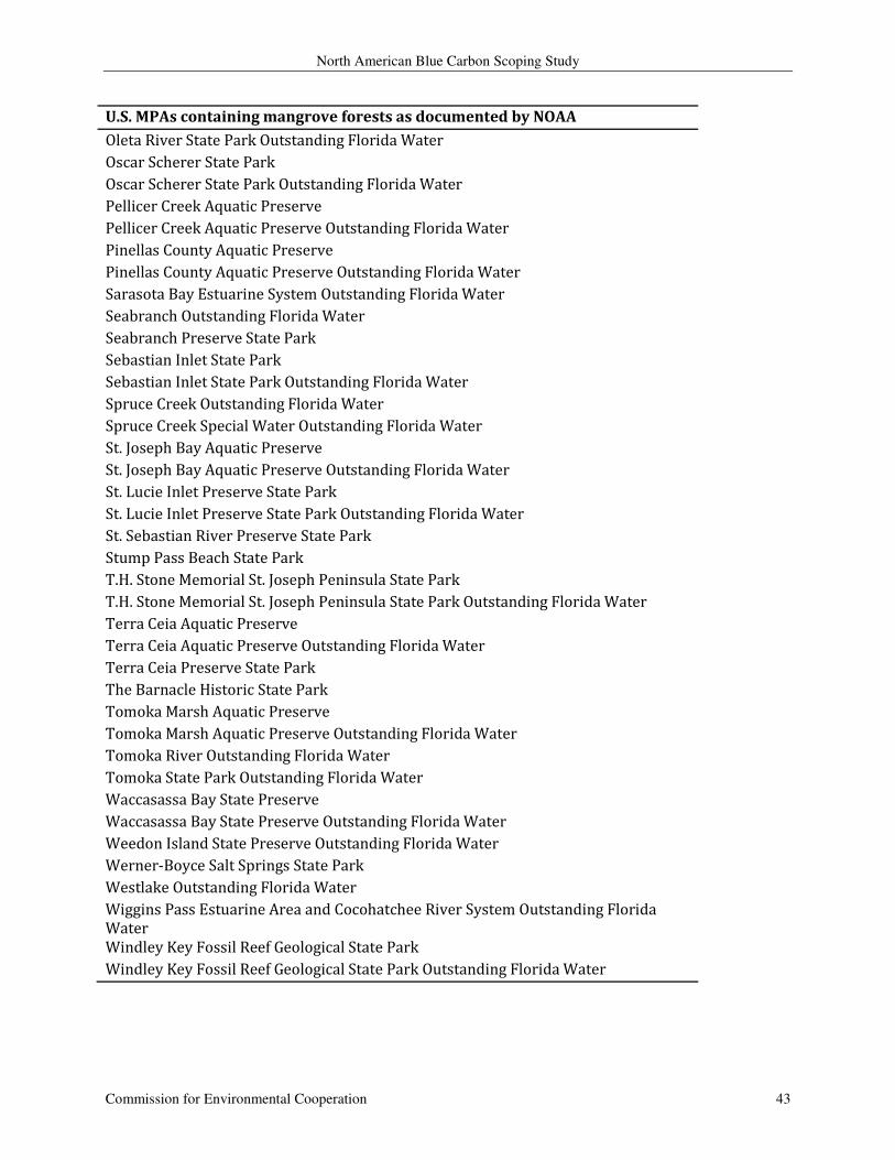
North American Blue Carbon Scoping Study
Commission for Environmental Cooperation 43
U.S. MPAs containing mangrove forests as documented by NOAA
Oleta River State Park Outstanding Florida Water
Oscar Scherer State Park
Oscar Scherer State Park Outstanding Florida Water
Pellicer Creek Aquatic Preserve
Pellicer Creek Aquatic Preserve Outstanding Florida Water
Pinellas County Aquatic Preserve
Pinellas County Aquatic Preserve Outstanding Florida Water
Sarasota Bay Estuarine System Outstanding Florida Water
Seabranch Outstanding Florida Water
Seabranch Preserve State Park
Sebastian Inlet State Park
Sebastian Inlet State Park Outstanding Florida Water
Spruce Creek Outstanding Florida Water
Spruce Creek Special Water Outstanding Florida Water
St. Joseph Bay Aquatic Preserve
St. Joseph Bay Aquatic Preserve Outstanding Florida Water
St. Lucie Inlet Preserve State Park
St. Lucie Inlet Preserve State Park Outstanding Florida Water
St. Sebastian River Preserve State Park
Stump Pass Beach State Park
T.H. Stone Memorial St. Joseph Peninsula State Park
T.H. Stone Memorial St. Joseph Peninsula State Park Outstanding Florida Water
Terra Ceia Aquatic Preserve
Terra Ceia Aquatic Preserve Outstanding Florida Water
Terra Ceia Preserve State Park
The Barnacle Historic State Park
Tomoka Marsh Aquatic Preserve
Tomoka Marsh Aquatic Preserve Outstanding Florida Water
Tomoka River Outstanding Florida Water
Tomoka State Park Outstanding Florida Water
Waccasassa Bay State Preserve
Waccasassa Bay State Preserve Outstanding Florida Water
Weedon Island State Preserve Outstanding Florida Water
Werner-Boyce Salt Springs State Park
Westlake Outstanding Florida Water
Wiggins Pass Estuarine Area and Cocohatchee River System Outstanding Florida
Water
Windley Key Fossil Reef Geological State Park
Windley Key Fossil Reef Geological State Park Outstanding Florida Water
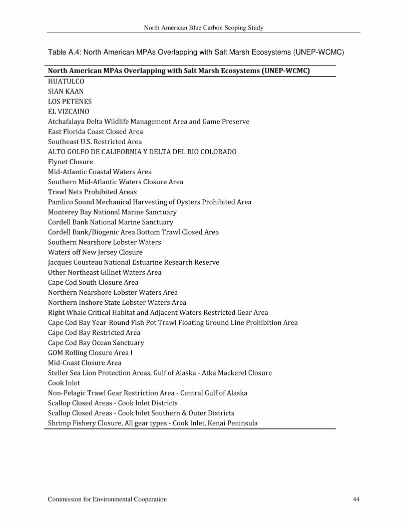
North American Blue Carbon Scoping Study
Commission for Environmental Cooperation 44
Table A.4: North American MPAs Overlapping with Salt Marsh Ecosystems (UNEP-WCMC)
North American MPAs Overlapping with Salt Marsh Ecosystems (UNEP-WCMC)
HUATULCO
SIAN KAAN
LOS PETENES
EL VIZCAINO
Atchafalaya Delta Wildlife Management Area and Game Preserve
East Florida Coast Closed Area
Southeast U.S. Restricted Area
ALTO GOLFO DE CALIFORNIA Y DELTA DEL RIO COLORADO
Flynet Closure
Mid-Atlantic Coastal Waters Area
Southern Mid-Atlantic Waters Closure Area
Trawl Nets Prohibited Areas
Pamlico Sound Mechanical Harvesting of Oysters Prohibited Area
Monterey Bay National Marine Sanctuary
Cordell Bank National Marine Sanctuary
Cordell Bank/Biogenic Area Bottom Trawl Closed Area
Southern Nearshore Lobster Waters
Waters off New Jersey Closure
Jacques Cousteau National Estuarine Research Reserve
Other Northeast Gillnet Waters Area
Cape Cod South Closure Area
Northern Nearshore Lobster Waters Area
Northern Inshore State Lobster Waters Area
Right Whale Critical Habitat and Adjacent Waters Restricted Gear Area
Cape Cod Bay Year-Round Fish Pot Trawl Floating Ground Line Prohibition Area
Cape Cod Bay Restricted Area
Cape Cod Bay Ocean Sanctuary
GOM Rolling Closure Area I
Mid-Coast Closure Area
Steller Sea Lion Protection Areas, Gulf of Alaska - Atka Mackerel Closure
Cook Inlet
Non-Pelagic Trawl Gear Restriction Area - Central Gulf of Alaska
Scallop Closed Areas - Cook Inlet Districts
Scallop Closed Areas - Cook Inlet Southern & Outer Districts
Shrimp Fishery Closure, All gear types - Cook Inlet, Kenai Peninsula
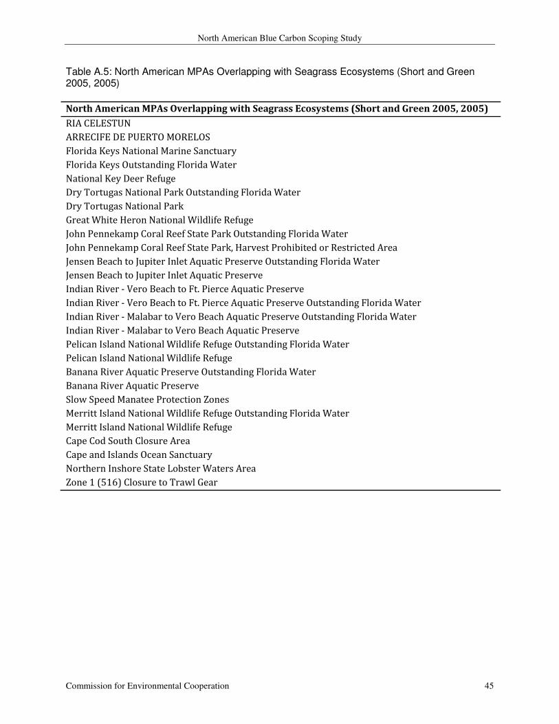
North American Blue Carbon Scoping Study
Commission for Environmental Cooperation 45
Table A.5: North American MPAs Overlapping with Seagrass Ecosystems (Short and Green 2005, 2005)
North American MPAs Overlapping with Seagrass Ecosystems (Short and Green 2005, 2005)
RIA CELESTUN
ARRECIFE DE PUERTO MORELOS
Florida Keys National Marine Sanctuary
Florida Keys Outstanding Florida Water
National Key Deer Refuge
Dry Tortugas National Park Outstanding Florida Water
Dry Tortugas National Park
Great White Heron National Wildlife Refuge
John Pennekamp Coral Reef State Park Outstanding Florida Water
John Pennekamp Coral Reef State Park, Harvest Prohibited or Restricted Area
Jensen Beach to Jupiter Inlet Aquatic Preserve Outstanding Florida Water
Jensen Beach to Jupiter Inlet Aquatic Preserve
Indian River - Vero Beach to Ft. Pierce Aquatic Preserve
Indian River - Vero Beach to Ft. Pierce Aquatic Preserve Outstanding Florida Water
Indian River - Malabar to Vero Beach Aquatic Preserve Outstanding Florida Water
Indian River - Malabar to Vero Beach Aquatic Preserve
Pelican Island National Wildlife Refuge Outstanding Florida Water
Pelican Island National Wildlife Refuge
Banana River Aquatic Preserve Outstanding Florida Water
Banana River Aquatic Preserve
Slow Speed Manatee Protection Zones
Merritt Island National Wildlife Refuge Outstanding Florida Water
Merritt Island National Wildlife Refuge
Cape Cod South Closure Area
Cape and Islands Ocean Sanctuary
Northern Inshore State Lobster Waters Area
Zone 1 (516) Closure to Trawl Gear