Embed Size (px)
Citation preview
Non-Convective High Winds Associated with ExtratropicalCyclones
John A. Knox1*, John D. Frye2, Joshua D. Durkee3 and Christopher M.Fuhrmann4
1Department of Geography, University of Georgia2Department of Geography, Kutztown University3Meteorology Program, Department of Geography and Geology, Western Kentucky University4Department of Geography, University of North Carolina at Chapel Hill
Abstract
Non-convective high winds are a damaging and potentially life-threatening weather phenomenonthat occurs in the absence of thunderstorms, tornadoes and tropical cyclones. The vast majority ofnon-convective high wind events develop in association with extratropical cyclones in mid-latituderegions. Interest in non-convective high winds is growing due to their societal impact, gaps in thescientific understanding of the triggering mechanisms for these events, and possible future changesin their frequency and intensity caused by climate change. In this article, non-convective highwinds are examined first in terms of their historical and cultural significance and climatologicalcharacteristics. Then, four possible mechanisms for the development of non-convective highwinds in extratropical cyclones are discussed and critiqued: topography; the isallobaric wind;tropopause folds associated with stratospheric intrusions and dry slots; and sting jets associatedwith marine frontal cyclones. Evidence for past and future trends in non-convective high windevent frequency and intensity is also briefly examined. New avenues for future work in thisemerging area of research are suggested that unite applied and basic research as well as climato-logical and case-study perspectives.
Introduction
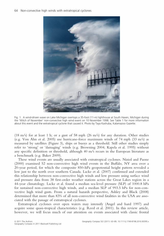
Non-convective high winds are an underrated, yet damaging and deadly weather phe-nomenon that is attracting increasing interest. Although less familiar than their convectivecounterparts (i.e. thunderstorms, tornadoes, tropical cyclones) in many parts of the world,these wind events occur in a number of regions globally in the mid-latitudes, including:the East Coast of North America (Ashley and Black 2008), the Great Lakes region of theUSA and Canada (Figure 1; Lacke et al. 2007; Niziol and Paone 2000), the northernGreat Plains of the USA (Kapela et al. 1995), the Pacific Northwest of the USA andCanada (Mass and Dotson 2010), the open waters of the North Pacific and North Atlan-tic (Von Ahn et al. 2005), Western Europe (Figure 2; Browning 2004; Wernli et al.2002), the Mediterranean basin (e.g. Tripoli et al. 2005), the Black Sea (e.g. Yarovayaet al. 2008), and the coast of southeastern Australia (e.g. Buckley and Leslie 2000). It islikely that future research will reveal that these winds occur in other regions as well.
In the relatively limited contemporary research literature on this subject, non-convec-tive high winds are not rigorously defined in terms of intensity. Some studies (e.g. Lackeet al. 2007) attempt to employ the typical US National Weather Service (NWS) thresh-olds for high wind events, i.e. sustained (peak 1 min) 10-m-elevation winds of 40 mph
Geography Compass 5/2 (2011): 63–89, 10.1111/j.1749-8198.2010.00395.x
ª 2011 The AuthorsGeography Compass ª 2011 Blackwell Publishing Ltd
(18 m ⁄ s) for at least 1 h; or a gust of 58 mph (26 m ⁄ s) for any duration. Other studies(e.g. Von Ahn et al. 2005) use hurricane-force maximum winds of 74 mph (33 m ⁄ s) asmeasured by satellites (Figure 3), ships or buoys as a threshold. Still other studies simplyrefer to ‘strong’ or ‘damaging’ winds (e.g. Browning 2004; Kapela et al. 1995) withoutany specific definition or threshold, although 40 m ⁄ s recurs in the European literature asa benchmark (e.g. Baker 2009).
These wind events are usually associated with extratropical cyclones. Niziol and Paone(2000) examined 52 non-convective high wind events in the Buffalo, NY area over a20-year period, for which the composite 850-hPa geopotential height pattern revealed alow just to the north over southern Canada. Lacke et al. (2007) confirmed and extendedthis relationship between non-convective high winds and low pressure using surface windand pressure data from 38 first-order weather stations across the Great Lakes region in a44-year climatology. Lacke et al. found a median sea-level pressure (SLP) of 1000.8 hPafor sustained non-convective high winds, and a median SLP of 993.5 hPa for non-con-vective high wind gusts. From a natural hazards perspective, Ashley and Black (2008)determined that more than 83% of all non-convective wind fatalities in the USA are asso-ciated with the passage of extratropical cyclones.
Extratropical cyclones over open waters may intensify (Angel and Isard 1997) andacquire some quasi-tropical characteristics (e.g. Reed et al. 2001). In this review article,however, we will focus much of our attention on events associated with classic frontal
Fig. 1. A wind-driven wave on Lake Michigan overtops a 35-foot (11-m) lighthouse at South Haven, Michigan duringthe ‘Witch of November’ non-convective high wind event on 10 November 1998. See Table 1 for more informationabout this event and the extratropical cyclone that caused it. Photo by Taya Kashuba, Kalamazoo Gazette.
64 Non-convective high winds with extratropical cyclones
ª 2011 The Authors Geography Compass 5/2 (2011): 63–89, 10.1111/j.1749-8198.2010.00395.xGeography Compass ª 2011 Blackwell Publishing Ltd

cyclones. Non-convective high winds due primarily to topography (e.g. gap winds) arenot discussed in this article.
Although other types of windstorms have a higher profile in many parts of the world(e.g. tornadoes and hurricanes in the eastern and central USA), non-convective highwinds are in many ways comparable in terms of societal impact. They have the potentialto be deadlier than hurricane winds or non-tornadic thunderstorm winds (Ashley and
0 12 17 23 27 33 42 48 56 63 74 150
Fig. 3. NASA QuikSCAT satellite data from 1600 UTC 1 December 2004, indicating near-surface winds in a NorthAtlantic extratropical cyclone as measured by scatterometer. Wind speed is in knots (colour bar in upper right). Thestrongest (hurricane-force) winds are depicted as red wind barbs. From Von Ahn et al. (2005); figure courtesy JoanVon Ahn, NOAA ⁄ NWS.
Fig. 2. Maximum wind gusts (in mph; gusts ‡100 mph in red) across France due to extratropical cyclone ‘Lothar’on 25–26 December 1999. Data from Meteo-France.
Non-convective high winds with extratropical cyclones 65
ª 2011 The Authors Geography Compass 5/2 (2011): 63–89, 10.1111/j.1749-8198.2010.00395.xGeography Compass ª 2011 Blackwell Publishing Ltd
Black 2008), and can account for more property and crop damage than thunderstormwinds or tornadoes in a typical year (Lacke et al. 2007). Europeans are generally moreaware of non-convective wind hazards because of ‘European windstorms’ that have along history of causing nautical disasters. More recently, several exceptional windstormsin Great Britain and northwestern Europe during the past quarter-century have stimulatedinterest among non-specialists and specialists alike (see examples in Fink et al. 2009).Total insurance losses in Europe associated with these storms have averaged over 1 billionEuros (approximately $1.5 billion) per year over this period (Browning 2004). In additionto direct wind deaths and damage, the action of wind on water can combine with otherfactors and lead to high seas and seiches that can cause additional extraordinary damageand loss of life. For example, the 1953 North Sea flood, caused by levee failures duringan intense extratropical cyclone, inflicted as many confirmed fatalities in the Netherlands(1835; Sterl et al. 2009) as did Hurricane Katrina in the US Gulf Coast in 2005 (1833;Beven et al. 2008).
The purpose of this article is twofold: (i) to summarize and assess the current state ofresearch on this emerging topic; and (ii) to unify our understanding of non-convectivewind events in both pure and applied research areas. As justification for the latter, a peru-sal of the bibliography of this article reveals that much of the work performed in NorthAmerica has been applied research, often climatological and often published in govern-ment documents, technical memos, or journals not typically read by academics interna-tionally. Meanwhile, in Europe a sizable body of research, mainly case studies ofexceptional events, exists mostly in academic journals. Of late, there has been a rapidexpansion of applied research on this subject related to wind energy and insurance inter-ests. In many instances, research on one side of the Atlantic reveals a lack of awareness ofwork done on the other side; and insurance-industry research tends to focus on Europebecause of the greater economic impact there. We intend for this review article to bridgethese divides and provide readers from a wide range of backgrounds and interests with acomprehensive and unified understanding of non-convective wind events, althoughadmittedly with a bit of a US accent.
Non-Convective High Wind Events: Historical and Cultural Perspectives
Historically, interest in non-convective high winds has been spurred by individual eventsoften linked to nautical disasters. The medieval ‘Ballad of Sir Patrick Spens’ (Abrams et al.1979, 396–397) tells a possibly true story of a Scottish shipwreck on the North Sea duringwinter in the late 13th century, presumably due to a ‘deadlie storme’. The ‘Great Storm’of 14 November 1854 on the Black Sea surprised and sank the British fleet during theCrimean War. Combined with the Royal Charter Storm of 1859, these two stormsspurred the development of daily weather forecasts in 1861 by Admiral Robert FitzRoy,formerly captain of The Beagle (Cox 2002, ch. 10). Similarly, the ‘Witch of Novembergales’ of the Great Lakes, the ‘Nor’easters’ of the East Coast, and the ‘Big Blows’ of thePacific Northwest have caused innumerable shipwrecks in North America. Table 1 sum-marizes some of the most significant non-convective wind events of modern times acrossthe globe.
Two North American events in Table 1 possess particular cultural importance andmultiple connections to atmospheric science. The November 1975 Great Lakes extratrop-ical cyclone helped sink the ore freighter Edmund Fitzgerald and its crew of 29 sailorson Lake Superior (Hultquist et al. 2006; Stonehouse 1977). The shipwreck inspiredCanadian singer–songwriter and sailor Gordon Lightfoot to compose and record a
66 Non-convective high winds with extratropical cyclones
ª 2011 The Authors Geography Compass 5/2 (2011): 63–89, 10.1111/j.1749-8198.2010.00395.xGeography Compass ª 2011 Blackwell Publishing Ltd
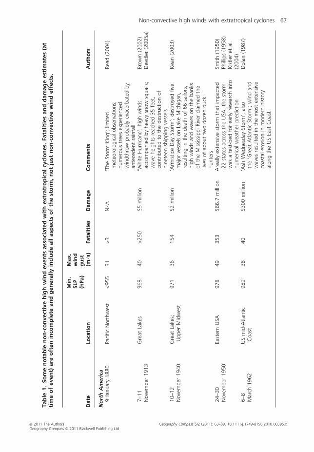
Tab
le1.
So
me
no
tab
len
on
-co
nvect
ive
hig
hw
ind
even
tsass
oci
ate
dw
ith
extr
atr
op
ical
cycl
on
es.
Fata
liti
es
an
dd
am
ag
eest
imate
s(a
tti
me
of
even
t)are
oft
en
inco
mp
lete
an
dg
en
era
lly
incl
ud
eall
asp
ect
so
fth
est
orm
,n
ot
just
no
n-c
on
vect
ive
win
deff
ect
s.
Date
Loca
tio
n
Min
.SLP
(hPa)
Max.
win
dg
ust
(m⁄s
)Fa
tali
ties
Dam
ag
eC
om
men
tsA
uth
ors
No
rth
Am
eri
ca9
Januar
y1880
Paci
fic
Nort
hw
est
<955
31
>3
N⁄A
‘The
Storm
Kin
g’;
limited
met
eoro
logic
alobse
rvat
ions;
num
erous
tree
sex
per
ience
dw
indth
row
pro
bab
lyex
acer
bat
edby
ante
ceden
tra
infa
ll
Rea
d(2
004)
7–1
1N
ove
mber
1913
Gre
atLa
kes
968
40
>250
$5
mill
ion
‘White
Hurr
ican
e’;
hig
hw
inds
acco
mpan
ied
by
hea
vysn
ow
squal
ls;
wav
ehei
ghts
reac
hed
35
feet
,co
ntr
ibute
dto
the
des
truct
ion
of
nin
etee
nsh
ippin
gve
ssel
s
Bro
wn
(2002)
Dee
dle
r(2
005a)
10–1
2N
ove
mber
1940
Gre
atLa
kes;
Upper
Mid
wes
t971
36
154
$2
mill
ion
‘Arm
istice
Day
Storm
’;des
troye
dfive
maj
or
vess
els
on
Lake
Mic
hig
an,
resu
ltin
gin
the
dea
thof
66
sailo
rs;
hig
hw
inds
and
wav
eson
the
ban
ksof
the
Mis
siss
ippiRiv
ercl
aim
edth
eliv
esof
about
two
doze
nduck
hunte
rs
Kea
n(2
003)
24–3
0N
ove
mber
1950
East
ern
USA
978
49
353
$66.7
mill
ion
Are
ally
exte
nsi
vest
orm
that
impac
ted
22
stat
esac
ross
the
USA
;th
est
orm
was
ate
st-b
edfo
rea
rly
rese
arch
into
num
eric
alw
eath
erpre
dic
tion
Smith
(1950)
Phill
ips
(1958)
Kis
tler
etal
.(2
004)
6–8
Mar
ch1962
US
mid
-Atlan
tic
Coas
t989
38
40
$300
mill
ion
‘Ash
Wed
nes
day
Storm
’;al
soth
e‘G
reat
Atlan
tic
Storm
’;w
ind
and
wav
esre
sulted
inth
em
ost
exte
nsi
veco
asta
ler
osi
on
inm
oder
nhis
tory
along
the
US
East
Coas
t
Dola
n(1
987)
Non-convective high winds with extratropical cyclones 67
ª 2011 The Authors Geography Compass 5/2 (2011): 63–89, 10.1111/j.1749-8198.2010.00395.xGeography Compass ª 2011 Blackwell Publishing Ltd

Tab
le1.
(Co
nti
nu
ed
)
Date
Loca
tio
n
Min
.SLP
(hPa)
Max.
win
dg
ust
(m⁄s
)Fa
tali
ties
Dam
ag
eC
om
men
tsA
uth
ors
12
Oct
ober
1962
Paci
fic
Nort
hw
est
960
71
46
$230
mill
ion
‘The
Big
Blo
w’;
born
from
the
rem
nan
tsof
maj
or
typhoon
that
cross
edth
enort
hPa
cific
Oce
an;
consi
der
edth
em
ost
pow
erfu
lex
trat
ropic
alcy
clone
inU
Shis
tory
Rea
d(2
005)
3–5
Oct
ober
1963
Bea
ufo
rtSe
aco
ast,
Ala
ska
976
33
0$3.2
5m
illio
nM
ost
seve
rest
orm
inBea
ufo
rtSe
aco
ast
his
tory
;nin
etee
nbuild
ings
inBar
row
des
troye
d,
drinki
ng
wat
erco
nta
min
ated
by
storm
surg
e
Lynch
etal
.(2
003)
9–1
0N
ove
mber
1975
Gre
atLa
kes
976
33
31
N⁄A
Storm
connec
ted
with
the
sinki
ng
of
the
ore
frei
ghte
rEd
mund
Fitz
ger
ald
on
Lake
Super
ior;
popula
rize
din
moder
ncu
lture
by
Can
adia
nfo
lksi
nger
Gord
on
Lightf
oot
Hold
en(1
991)
Knox
and
Ack
-er
man
(1996)
Hultquis
tet
al.
(2006)
1–5
Febru
ary
1976
New
Engla
nd
USA
;C
anad
ian
mar
itim
es
957
52
N⁄A
$22
mill
ion
‘The
Gro
undhog
Day
Gal
e’;
maj
or
bea
cher
osi
on
and
inla
nd
floodin
gac
ross
New
Engla
nd;
maj
or
floodin
gin
the
bay
sal
ong
the
coas
tof
New
foundla
nd;
atle
ast
one
frei
ghte
rlo
st
Des
pla
nque
and
Moss
man
(1999)
25–2
7Ja
nuar
y1978
Gre
atLa
kes
956
45
70
N⁄A
‘The
Gre
atBliz
zard
’an
d‘C
leve
land
Super
bom
b’;
som
eof
the
low
est
extr
atro
pic
alcy
clone
surf
ace
pre
ssure
sev
erre
cord
edin
the
contiguous
USA
and
east
ern
Can
ada.
Cle
vela
nd,
Ohio
all-tim
e-lo
wpre
ssure
reco
rdbro
ken
by
13
hPa
Bla
ckburn
(1978)
Wag
ner
(1978)
Salm
on
and
Smith
(1980)
Hak
imet
al.
(1995)
Dee
dle
r(2
005b)
68 Non-convective high winds with extratropical cyclones
ª 2011 The Authors Geography Compass 5/2 (2011): 63–89, 10.1111/j.1749-8198.2010.00395.xGeography Compass ª 2011 Blackwell Publishing Ltd

Tab
le1.
(Co
nti
nu
ed
)
Date
Loca
tio
n
Min
.SLP
(hPa)
Max.
win
dg
ust
(m⁄s
)Fa
tali
ties
Dam
ag
eC
om
men
tsA
uth
ors
5–7
Febru
ary
1978
New
Engla
nd
USA
984
41
13
$1
bill
ion
Hig
hw
inds
and
reco
rdsn
ow
fall
pro
duce
done
of
the
most
mem
ora
ble
bliz
zard
sin
US
his
tory
;tides
3–4
feet
above
norm
al;
coas
tal
floodin
gan
der
osi
on;
num
erous
lighth
ouse
sdam
aged
Koci
nan
dU
ccel
lini
(2004)
NC
DC
(1978)
30–3
1O
ctober
1991
East
ern
Nort
hA
mer
ica
972
35
5$200
mill
ion
‘The
Perf
ect
Storm
’;a
stro
ng
coas
tal
cycl
one
join
edw
ith
the
rem
nan
tsof
Hurr
ican
eG
race
;w
ave
hei
ghts
reac
hed
35
feet
;lo
ng-d
ura
tion
even
t(1
14
h)
with
hig
hw
ind
and
wav
esex
tendin
gove
r3500
kmof
coas
tlin
e
Dav
isan
dD
ola
n(1
992)
29
Nove
mber
1991
South
ern
Cal
iforn
ia1003
34
17
N⁄A
Hig
hw
inds
ove
rth
eSa
nJo
aquin
Val
ley
pro
duce
da
maj
or
dust
storm
that
resu
lted
inm
ultip
leco
llisi
ons
invo
lvin
g164
cars
along
sect
ions
of
Inte
rsta
te-5
Paule
yet
al.
(1996)
12–1
3M
arch
1993
East
ern
USA
960
45
300
$6
bill
ion
‘Super
storm
’or
‘Sto
rmof
the
Cen
tury
’;bliz
zard
conditio
ns
inN
ewEn
gla
nd;
hig
hw
inds,
wes
terly
gal
esbeh
ind
cold
front
acro
ssm
id-A
tlan
tic
and
south
ern
USA
;co
asta
ler
osi
on
from
Florida
toN
ewEn
gla
nd
Koci
net
al.
(1995)
10
Nove
mber
1998
Gre
atLa
kes
963
42
10
$40
mill
ion
‘Witch
of
Nove
mber
’;ex
actly
23
year
sto
the
day
of
the
1975
storm
that
sank
the
Edm
und
Fitz
ger
ald
Iaco
pel
lian
dK
nox
(2001)
10–1
1A
ugust
2000
Bar
row
,A
lask
a989
33
0$7.7
mill
ion
Rec
ord
win
ds
atBar
row
;$6
mill
ion
dre
dge
des
troye
d,
40
build
ings
unro
ofe
d;
Prudhoe
Bay
reco
rded
nea
r-100-y
ear
storm
surg
e
Lynch
etal
.(2
003)
Non-convective high winds with extratropical cyclones 69
ª 2011 The Authors Geography Compass 5/2 (2011): 63–89, 10.1111/j.1749-8198.2010.00395.xGeography Compass ª 2011 Blackwell Publishing Ltd

Tab
le1.
(Co
nti
nu
ed
)
Date
Loca
tio
n
Min
.SLP
(hPa)
Max.
win
dg
ust
(m⁄s
)Fa
tali
ties
Dam
ag
eC
om
men
tsA
uth
ors
25–2
7O
ctober
2010
Upper
Mid
wes
tU
.S.
955
35
1N
⁄AO
ne
of
most
inte
nse
extr
atro
pic
alcy
clones
on
reco
rdin
low
er48
United
Stat
es;
wid
espre
adhig
hw
inds
acro
ssupper
Mid
wes
t
htt
p:/
/w
ww
.crh
.noaa
.gov/
mpx/
?n=
10oct
2627
So
uth
Am
eri
ca23–2
4A
ugust
2005
Uru
guay
992
>45
10
N⁄A
Pow
erfu
lex
trat
ropic
alcy
clone
with
hig
hw
inds
and
hea
vyra
infa
ll;co
nsi
der
edth
eco
untr
y’s
wors
tst
orm
innea
rly
hal
fa
centu
ry;
thousa
nds
of
felle
dtr
ees
and
dam
aged
hom
es;
tens
of
thousa
nds
without
elec
tric
ity
Padget
tet
al.
(2005)
NC
DC
(2005)
Eu
rop
e24
Nove
mber
–3D
ecem
ber
1703
UK
973
54
>10,0
00
N⁄A
‘The
Gre
atSt
orm
’;co
nsi
der
edth
ew
ors
tnat
ura
ldis
aste
rin
the
UK
;th
ousa
nds
of
lives
lost
atse
a;at
leas
ta
doze
nRoya
lN
avy
ship
slo
st
Lam
ban
dFr
yden
dah
l(1
991)
Whee
ler
(2003)
6–7
Januar
y1839
Wes
tC
oas
tof
Irel
and
918
>50
100–3
00
(est
.)>
£200
mil-
lion
‘The
Nig
ht
of
the
Big
Win
d’;
one
of
the
stro
nges
tst
orm
sin
his
tory
toaf
fect
the
Iris
hco
ast;
42
ship
sw
ere
dam
aged
or
capsi
zed;
trem
endous
agricu
ltura
ldam
age;
insp
ired
apopula
rIris
hnove
lan
dso
ng
⁄poem
of
the
sam
enam
e
Shie
lds
and
Fitz
ger
ald
(1989)
Fors
ythe
etal
.(2
000)
Swee
ny
(2000)
25–2
6O
ctober
1859
Wes
tC
oas
tof
Gre
atBrita
in960
>33
>800
N⁄A
‘The
Roya
lC
har
ter
Storm
’;w
ors
tw
indst
orm
of
the
19th
centu
ryin
the
British
Isle
s;ove
r100
ship
ssu
nk
incl
udin
gth
eRoya
lC
har
ter
(ove
r400
dea
d)
on
the
Wal
esco
ast;
insp
ired
Fitz
Roy’
sat
tem
pt
tois
sue
storm
fore
cast
s
Cox
(2002,
ch.
10)
McK
ee(2
000)
70 Non-convective high winds with extratropical cyclones
ª 2011 The Authors Geography Compass 5/2 (2011): 63–89, 10.1111/j.1749-8198.2010.00395.xGeography Compass ª 2011 Blackwell Publishing Ltd
Tab
le1.
(Co
nti
nu
ed
)
Date
Loca
tio
n
Min
.SLP
(hPa)
Max.
win
dg
ust
(m⁄s
)Fa
tali
ties
Dam
ag
eC
om
men
tsA
uth
ors
31
Januar
y–1
Febru
ary
1953
UK
;Th
eN
ether
lands
966
56
>2000
£1
bill
ion
‘The
Nort
hSe
aFl
ood’;
hig
hw
inds
and
tidal
wav
esca
use
ddyk
ean
dse
aw
all
failu
res
and
mas
sive
floodin
g;
num
erous
ship
san
dfe
rrie
slo
stat
sea
Lam
ban
dFr
yden
dah
l(1
991)
Ster
let
al.
(2009)
13–1
4A
ugust
1979
UK
979
36
15
N⁄A
Hig
hw
inds
pro
duce
dm
assi
vew
aves
thro
ugh
the
Englis
hC
han
nel
during
the
28th
Fast
net
yach
ting
race
;24
of
the
303
yach
tspar
tici
pat
ing
inth
era
cew
ere
lost
or
aban
doned
Pedgle
y(1
997)
15–1
6O
ctober
1987
Engla
nd;
Fran
ce952
>50
18
£2
bill
ion
Know
nas
‘The
Gre
atSt
orm
’;m
illio
ns
of
felle
dtr
ees;
hig
hes
tw
inds
occ
urr
edduring
the
ove
rnig
ht
hours
;poorly
fore
cast
edby
the
UK
Met
eoro
logic
alO
ffice
Burt
and
Man
sfiel
d(1
988)
Bro
wnin
g(2
004)
27
Febru
ary
1990
Switze
rlan
d948
>60
64
$5
bill
ion
‘Viv
ian’;
hig
hw
inds
topple
d5
mill
ion
m3
of
tim
ber
inSw
itze
rlan
dal
one;
seve
redam
age
and
dis
ruption
cause
dby
win
d-b
low
ntr
ees
and
deb
ris
Schuep
pet
al.
(1994)
3D
ecem
ber
1999
Nort
hSe
a953
51
6£1.4
bill
ion
‘Anat
ol’;
hig
hw
inds
pro
duce
dre
cord
storm
surg
eal
ong
the
nort
her
nD
anis
han
dG
erm
anco
ast;
the
stro
nges
tst
orm
tohit
Den
mar
kin
the
20th
centu
ry
Ulb
rich
etal
.(2
001)
Pear
ceet
al.
(2001)
24–2
6D
ecem
ber
1999
Fran
ce;
Ger
man
y;Sw
itze
rlan
d
974
58
50
£3.1
bill
ion
(Loth
ar&
Mar
tin)
‘Loth
ar’;
dam
age
report
edat
Notr
eD
ame
inPa
ris
and
the
par
kof
Ver
saill
es;
ove
r2000
acre
sof
tim
ber
chip
spro
duce
dfr
om
felle
dtr
ees
Ulb
rich
etal
.(2
001)
Pear
ceet
al.
(2001)
Wer
nli
etal
.(2
002)
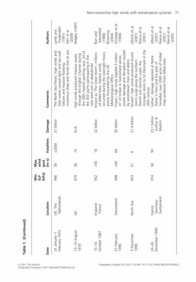
Non-convective high winds with extratropical cyclones 71
ª 2011 The Authors Geography Compass 5/2 (2011): 63–89, 10.1111/j.1749-8198.2010.00395.xGeography Compass ª 2011 Blackwell Publishing Ltd

Tab
le1.
(Co
nti
nu
ed
)
Date
Loca
tio
n
Min
.SLP
(hPa)
Max.
win
dg
ust
(m⁄s
)Fa
tali
ties
Dam
ag
eC
om
men
tsA
uth
ors
27
Dec
ember
1999
Fran
ce;
Spai
n965
40
>150
See
above
‘Mar
tin’;
exte
nsi
vetr
eedam
age,
couple
dw
ith
dam
age
from
Anat
ol
and
Loth
ar,
cause
dm
ajor
dis
ruptions
totr
ansp
ort
atio
n;
mill
ions
without
pow
erre
gio
nal
lyup
to1
wee
k
Ulb
rich
etal
.(2
001)
Pear
ceet
al.
(2001)
7–9
Januar
y2005
UK
;Sc
andin
avia
956
46
>17
>£1
bill
ion
‘Gudru
n’
(Norw
ay)
and
‘Erw
in’
(Ger
man
y);
75
mill
ion
m3
of
felle
dtr
ees
thro
ughout
Scan
din
avia
;re
cord
floodin
gdue
tow
ind-d
rive
nw
aves
inw
este
rnU
K(C
arlis
le,
Engla
nd)
Bak
er(2
009)
15–1
9Ja
nuar
y2007
Wes
tern
Euro
pe
964
63
47
£4
bill
ion
‘Kyr
ill’;
maj
or
dis
ruption
of
air,
land,
and
sea
tran
sport
atio
n;
mill
ions
without
pow
er;
asm
any
as62
mill
ion
tree
supro
ote
d
Fink
etal
.(2
009)
26–2
8Fe
bru
ary
2010
Wes
tern
Euro
pe
966
54
At
leas
t62
€1.5
–3bill
ion
‘Xyn
thia
’;5th
dea
dlie
stw
inte
rst
orm
inEu
rope
inpas
t60
year
s;st
orm
surg
ew
ith
8-m
wav
esin
coas
talFr
ance
;m
illio
ns
without
pow
erin
Fran
cean
dPo
rtugal
htt
p:/
/w
ww
.knm
i.nl/
cms/
mm
bas
e/at
tach
men
ts/
81817
Med
iterr
an
ean
14
Nove
mber
1854
Bla
ckSe
aN
⁄AN
⁄AN
⁄AN
⁄ASu
rprise
storm
during
Crim
ean
War
3w
eeks
afte
r‘C
har
ge
of
the
Light
Brigad
e’w
reck
edBritish
and
Fren
chw
arsh
ips,
sinki
ng
win
ter
supplie
s;‘e
norm
ous
loss
eson
land
and
sea’
Cox
(2002,
chs
10
and
11)
25–2
9Se
pte
mber
1979
Bla
ckSe
a992
25
N⁄A
N⁄A
Nea
rly
stat
ionar
ym
esosc
ale
cycl
one
ove
rso
uth
wes
tBla
ckSe
ale
dto
del
ays
of
cruis
esh
ips
from
the
Crim
eaan
dO
des
sato
Ista
nbul
Yar
ova
yaet
al.
(2008)
72 Non-convective high winds with extratropical cyclones
ª 2011 The Authors Geography Compass 5/2 (2011): 63–89, 10.1111/j.1749-8198.2010.00395.xGeography Compass ª 2011 Blackwell Publishing Ltd

Tab
le1.
(Co
nti
nu
ed
)
Date
Loca
tio
n
Min
.SLP
(hPa)
Max.
win
dg
ust
(m⁄s
)Fa
tali
ties
Dam
ag
eC
om
men
tsA
uth
ors
19–2
2D
ecem
ber
1979
Wes
tern
Med
iter
ranea
n982
30
N⁄A
N⁄A
Rap
idly
dee
pen
ing
‘bom
b’
cycl
one
follo
wed
unusu
altr
ack
nort
hw
ard
from
Afr
ica
toea
stof
Bal
earic
Isla
nds;
man
ytr
ees
upro
ote
dan
dso
me
seas
hore
build
ings
affe
cted
on
isla
nds
Hom
aret
al.
(2002)
9–1
0N
ove
mber
2001
Alg
eria
989
33
740
N⁄A
Dev
asta
ting
floodin
gra
ins
and
win
dst
orm
inA
lgie
rsca
use
dby
storm
rese
mblin
gU
S‘S
torm
of
the
Cen
tury
’
Trip
oli
etal
.(2
005)
Au
stra
lia
an
dN
ew
Zeala
nd
10
April1968
Nort
hIs
land,
New
Zeal
and
N⁄A
51
53
N⁄A
‘The
Wah
ine
Dis
aste
r’;
Cyc
lone
Gis
elle
conve
rged
with
ast
rong
extr
atro
pic
alcy
clone
nea
rW
ellin
gto
n,
NZ;
connec
ted
with
the
capsi
zing
of
the
pas
senger
ferr
yW
ahin
ein
Wel
lingto
nH
arbour;
signifi
cant
dam
age
tofo
rest
son
the
Nort
hIs
land
Hill
(1970)
Shaw
(1983)
25–2
8D
ecem
ber
1998
South
east
ern
Aust
ralia
978
47
6N
⁄AH
igh
win
ds
pro
duce
dhea
vysu
rfduring
the
54th
Sydney
-to-H
obar
tY
acht
Rac
e;su
bse
quen
tre
scue
effo
rtth
ebig
ges
tpea
cetim
em
arin
ere
scue
inA
ust
ralia
’shis
tory
Buck
ley
and
Lesl
ie(2
000)
Non-convective high winds with extratropical cyclones 73
ª 2011 The Authors Geography Compass 5/2 (2011): 63–89, 10.1111/j.1749-8198.2010.00395.xGeography Compass ª 2011 Blackwell Publishing Ltd

meteorologically astute and haunting ballad on the subject (Knox and Ackerman 1996).Lightfoot’s song, the 1976 international hit ‘The Wreck of the Edmund Fitzgerald’, andthe lingering mystery surrounding the wreck have elevated the Fitzgerald story into amythic ‘Titanic of the Great Lakes’ (Ackerman and Knox 2007, ch. 10). Ironically, thisstorm was employed by Hoskins and Pedder (1980) in their celebrated application ofquasigeostrophic Q-vector theory without any reference to the wider significance of thestorm, or even a base map to indicate its location. Later, Hultquist et al. (2006) per-formed a high-resolution numerical investigation of the storm, accurately simulatingexceptional winds and seas in the location of the shipwreck (Figure 4).
A hybrid extratropical–tropical cyclone on Halloween 1991 that led to twelve deathsin fishing vessels off the USA and Canadian East Coast similarly passed into legend, viathe bestselling book The Perfect Storm (Junger 1997) and 2000 film of the same name. Itreceived its nickname, now broadly used in a variety of contexts throughout the English-speaking world, from Boston NWS meteorologist and former National Hurricane Centerforecaster Bob Case. In another unusual intersection of culture and science, the film’sOscar-nominated visual effects included compelling computer-generated ocean waveimagery co-created by former atmospheric science professor John Anderson, a fluiddynamics expert then working at Lucasfilm’s Industrial Light and Magic.
In addition to nautical tragedies involving freight or fishing, two yacht-race disasterswere also precipitated by non-convective high wind events. During the August 1979Fastnet race in England (Pedgley 1997; Rousmaniere 1980), over 100 yachts wereknocked over or capsized in 50-foot (15-m) seas caused by hurricane-force wind gusts inthe rear of an intense extratropical cyclone, causing fifteen fatalities and necessitating thelargest peacetime rescue operation in the Royal Navy’s history. Nineteen years later onBoxing Day 1998, the Sydney-to-Hobart race was similarly disrupted by an intense extra-tropical cyclone with wind gusts to 106 mph (47 m ⁄ s). Over half of the competing yachtsretired from the race due to high winds and 80-foot-plus (25-m) waves; six sailorsdied despite Australia’s largest-ever peacetime rescue mission (Buckley and Leslie 2000;Mundle 1999).
Non-Convective High Wind Climatologies
The first comprehensive climatological study of extratropical cyclones with strong windsappears to have been by the Canadian government meteorologist Lewis (1987). Lewisexamined 100 storms with sustained (1-min mean) winds greater than a threshold of55 mph (25 m ⁄ s) that traversed the Great Lakes between 1957 and 1985. He determinedthat about 0.25% of ship observations of wind made on the Great Lakes duringNovember, December and January exceeded this threshold. Angel (1996) reanalysedLewis’s results and found that 92% of the 100 storms were extratropical cyclones; 83% ofthese cyclones occurred in November through March.
Lamb and Frydendahl (1991) employed historical synoptic weather maps, ship observa-tions and a variety of non-meteorological data (e.g. church records, port records, farmdiaries) to analyse the great windstorms of the past 500 years in Great Britain and the seasand coasts of northwest Europe. A total of 166 storms dating back to the 16th centurywere analysed and ranked according to a storm severity index, which accounts for windspeed, areal coverage of damaging winds and duration. Although an upward trend instorm intensity in the North Sea region has been suggested since about 1950, their studyappears to suggest even greater storminess in past centuries.
74 Non-convective high winds with extratropical cyclones
ª 2011 The Authors Geography Compass 5/2 (2011): 63–89, 10.1111/j.1749-8198.2010.00395.xGeography Compass ª 2011 Blackwell Publishing Ltd

(a)
(b)
(c)
Fig. 4. High-resolution simulation results for the November 1975 ‘Edmund Fitzgerald’ storm and its impact on LakeSuperior: (a) wind speed (in knots, shaded) at 0000 UTC 11 November 1975; (b) significant wave heights at thesame time as in (a); and (c) significant wave heights at 0100 UTC 11 November 1975, approximately 40 min afterthe shipwreck (location indicated by an ‘x’ on each plot). Simulated winds at the shipwreck site at 0100 UTC are>45 knots (22.5 m ⁄ s) and significant wave heights are 25.6 feet (7.8 m). From Hultquist et al. (2006); figure cour-tesy Tom Hultquist, NOAA ⁄ NWS.
Non-convective high winds with extratropical cyclones 75
ª 2011 The Authors Geography Compass 5/2 (2011): 63–89, 10.1111/j.1749-8198.2010.00395.xGeography Compass ª 2011 Blackwell Publishing Ltd
Feren (1990) explored explosive cyclogenesis in the eastern portion of Bass Strait,which separates Australia and Tasmania, from 1970 to 1989. Feren focused on storms thatproduced very high waves (at least 17 feet, or 5 m). His results indicate a maximum infrequency of these events during June through August, i.e. Southern Hemisphere winter.
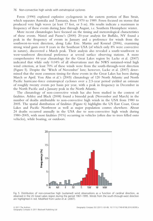
More recent climatologies have focused on the timing and meteorological characteristicsof these events. Niziol and Paone’s (2000) 20-year analysis for Buffalo, NY found apeak in the frequency of events in January and a preference for winds from thesouthwest-to-west direction, along Lake Erie. Martin and Konrad (2006), examiningstrong wind gusts over 8 years in the Southeast USA (of which only 8% were convectivein nature), discovered a March peak. Their analysis also revealed a south–southwest towest–southwest directional preference at several surface observing stations. A morecomprehensive 44-year climatology for the Great Lakes region by Lacke et al. (2007)indicated that while only 0.04% of all observations met the NWS sustained-wind highwind criterion, at least 70% of these winds were from the south-through-west direction(Figure 5). Despite the ‘Witch of November’ lore; however, Lacke et al. (2007) deter-mined that the most common timing for these events in the Great Lakes has been duringMarch or April. Von Ahn et al.’s (2005) climatology of 120 North Atlantic and NorthPacific hurricane-force extratropical cyclones over a 2.5-year period yielded an estimateof roughly twenty events per basin per year, with a peak in frequency in December inthe North Pacific and a January peak in the North Atlantic.
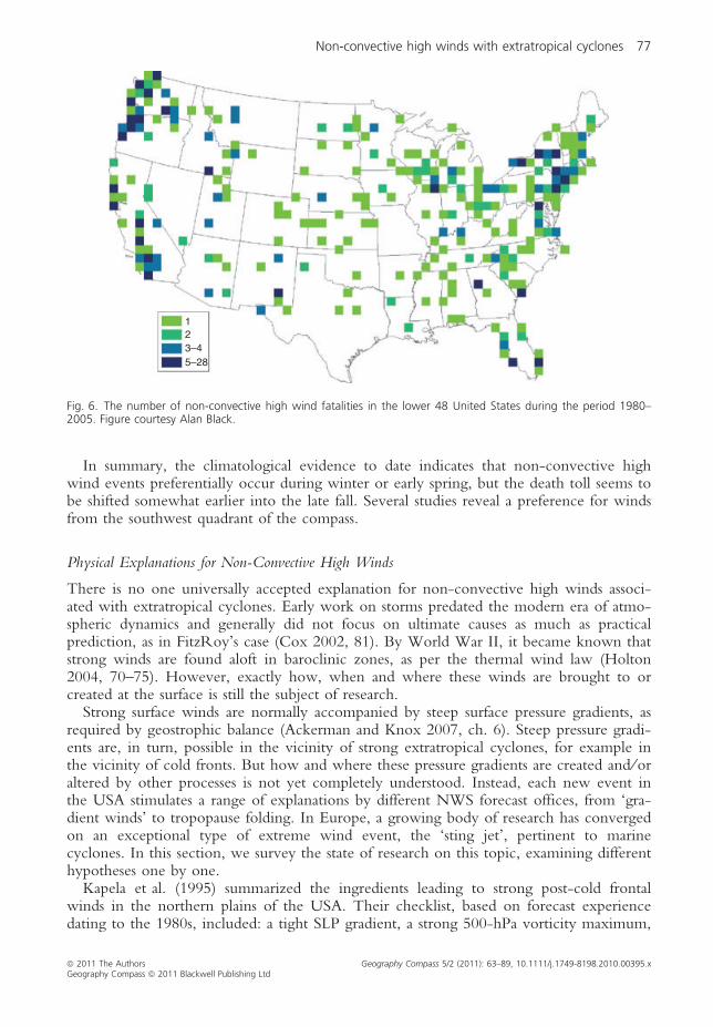
The climatology of non-convective winds has also been studied in the context offatalities. Ashley and Black (2008) found a bimodal peak (November and March) in thenumber of deaths attributable to non-convective high winds in the USA from 1980 to2005. The spatial distribution of fatalities (Figure 6) highlights the US East Coast, GreatLakes and Pacific Northwest as well as major population centres elsewhere. About24 deaths occurred annually in the USA due to non-convective high winds during1980–2005, with most fatalities (91%) occurring in vehicles (often due to trees felled ontovehicles), while boating, or outdoors.
Fig. 5. Distribution of non-convective high (sustained) wind observations as a function of cardinal direction, asobserved in the US Great Lakes region during the period 1967–1995. Winds from the south-through-west directionare highlighted in red. Modified from Lacke et al. (2007).
76 Non-convective high winds with extratropical cyclones
ª 2011 The Authors Geography Compass 5/2 (2011): 63–89, 10.1111/j.1749-8198.2010.00395.xGeography Compass ª 2011 Blackwell Publishing Ltd
In summary, the climatological evidence to date indicates that non-convective highwind events preferentially occur during winter or early spring, but the death toll seems tobe shifted somewhat earlier into the late fall. Several studies reveal a preference for windsfrom the southwest quadrant of the compass.
Physical Explanations for Non-Convective High Winds
There is no one universally accepted explanation for non-convective high winds associ-ated with extratropical cyclones. Early work on storms predated the modern era of atmo-spheric dynamics and generally did not focus on ultimate causes as much as practicalprediction, as in FitzRoy’s case (Cox 2002, 81). By World War II, it became known thatstrong winds are found aloft in baroclinic zones, as per the thermal wind law (Holton2004, 70–75). However, exactly how, when and where these winds are brought to orcreated at the surface is still the subject of research.
Strong surface winds are normally accompanied by steep surface pressure gradients, asrequired by geostrophic balance (Ackerman and Knox 2007, ch. 6). Steep pressure gradi-ents are, in turn, possible in the vicinity of strong extratropical cyclones, for example inthe vicinity of cold fronts. But how and where these pressure gradients are created and ⁄oraltered by other processes is not yet completely understood. Instead, each new event inthe USA stimulates a range of explanations by different NWS forecast offices, from ‘gra-dient winds’ to tropopause folding. In Europe, a growing body of research has convergedon an exceptional type of extreme wind event, the ‘sting jet’, pertinent to marinecyclones. In this section, we survey the state of research on this topic, examining differenthypotheses one by one.
Kapela et al. (1995) summarized the ingredients leading to strong post-cold frontalwinds in the northern plains of the USA. Their checklist, based on forecast experiencedating to the 1980s, included: a tight SLP gradient, a strong 500-hPa vorticity maximum,
123–45–28
Fig. 6. The number of non-convective high wind fatalities in the lower 48 United States during the period 1980–2005. Figure courtesy Alan Black.
Non-convective high winds with extratropical cyclones 77
ª 2011 The Authors Geography Compass 5/2 (2011): 63–89, 10.1111/j.1749-8198.2010.00395.xGeography Compass ª 2011 Blackwell Publishing Ltd
a large isallobaric gradient, subsidence, cold-air advection, a steep lapse rate, a ‘dry slot’ inwater vapour satellite imagery, an upper-tropospheric jet streak and small directional windshear. Using this ingredients-based checklist as a general guide, we now turn to the mostcommonly discussed hypotheses for non-convective high winds.
TOPOGRAPHY
Kapela et al. (1995) did not mention topography, which is not particularly relevant onthe homogeneously flat Great Plains. However, differences in elevation and surfaceroughness, particularly near coastal regions, have been hypothesized as a contributing fac-tor in non-convective high wind events by several researchers.
Niziol and Paone (2000) linked the preference for southwesterly and westerly highwinds at Buffalo to the presence of Lake Erie to the southwest of Buffalo. The authorshypothesized that Buffalo’s location on elliptically shaped Lake Erie may play an impor-tant role in the stratification of wind direction, by channelling the wind at its narrowingeastern end. However, Lacke et al. (2007) demonstrated that the same preference forsouthwesterly winds exists throughout the Great Lakes region, independent of upwindtopographic or geographic features.
Crupi (2004) and Hultquist et al. (2006) both suggested that the topography of theUpper Peninsula of Michigan played a role in non-convective high winds on Lake Supe-rior. In the former, a funnelling of air through a canal was hypothesized to contribute toan April 1997 event (Crupi 2004). In the latter, an acceleration of winds was noted oversouth-central Lake Superior during the Fitzgerald storm (see figure 4, from Hultquist et al.2006) that was ‘likely enhanced’ by coastal convergence just north of the high terrain ofthe Huron Mountains (maximum elevation 1979 feet or 603 m) and the Keweenaw Pen-insula (maximum elevation <1640 feet or 500 m). However, Tripoli et al. (2005) ruledout topographic influences on the development of the November 2001 Algerian cycloneand wind event via a series of numerical simulations that alternately included or excludedAfrican topography.
Three other studies for other regions have also downplayed the role of topography.Mass and Dotson (2010) have summarized the mixed results of research on interactionsbetween Pacific Northwest cyclones and the terrain of that region, noting that ‘majorquestions remain’ regarding the role of topography in coastal wind enhancement. Pauleyet al. (1996) ascribed a lesser, secondary role to topography (via mountain waves and atopographically induced low) in the generation of a deadly dust storm due to non-con-vective high winds in central and southern California. Homar et al. (2002) also deter-mined that orography played only a weak role in the development of a deep cyclonewith 67 mph (30 m ⁄ s) gusts over the western Mediterranean in December 1979.
In summary, although topography certainly can play a role in extreme wind eventsassociated with extratropical cyclones, it is evident from the research as well as the manyoccurrences of extreme winds over the oceans that it is neither essential nor even aprimary cause.
ISALLOBARIC WIND
A common explanation for non-convective high wind events in NWS discussions is theisallobaric wind, defined as the wind generated when the Coriolis force exactly balances alocally accelerating geostrophic wind (Glickman 2000). This wind is directed towardslocally falling pressures and is normal to lines of equal pressure change, or isallobars. The
78 Non-convective high winds with extratropical cyclones
ª 2011 The Authors Geography Compass 5/2 (2011): 63–89, 10.1111/j.1749-8198.2010.00395.xGeography Compass ª 2011 Blackwell Publishing Ltd
larger the gradient of pressure change, the faster the isallobaric wind. As a result, the isal-lobaric wind can be sizable on the flanks of intense, rapidly intensifying, and ⁄or quicklypropagating extratropical cyclones.
Richwien (1980), in an early examination of the Fitzgerald storm, attributed the highwinds on Lake Superior to the combination of gradient and isallobaric winds. This asser-tion was based on calculations made at one point in the vicinity of the shipwreck. Later,Crupi (2004) made similar calculations and inferences for an April 1997 wind event nearHoughton, Michigan. Based on the results of two case studies of non-convective highwinds in New York state in February 1997, Niziol and Paone (2000) noted that ‘manyof the processes conducive to high winds that occur higher in the atmosphere arereflected in … surface pressure rise ⁄ fall couplets that contribute to an isallobaric compo-nent of the wind’. More recently, NWS meteorologists have linked isallobaric winds tothe damaging ($1.5 billion) windstorm in the US Ohio Valley in September 2008 associ-ated with the extratropical transition of Hurricane Ike (Stoppkotte et al. 2009).
The isallobaric wind is prone to misuse, however. From the time of Haurwitz (1946),it has been noted that the isallobaric wind is but one (and not necessarily the dominant)component of the ageostrophic wind, and that it is usually calculated in a very approxi-mate manner. Also, the isallobaric wind must be added vectorially to other wind compo-nents; it is not necessarily parallel to the geostrophic or gradient wind in intense cyclones.For these reasons, caution must be applied in attributing non-convective high winds toisallobaric winds. However, Kwon and Lim (1999, figure 9) have shown that the combi-nation of isallobaric and advective ageostrophic winds does lead to a net meridionallower-level ageostrophic wind in the southwest quadrant of an unstable-mode (asopposed to a neutral-mode) baroclinic low, where many non-convective high windevents occur (see below). Therefore, there still appears to be merit in considering isallo-baric contributions as a mechanism for non-convective high winds associated with extra-tropical cyclones.
TROPOPAUSE FOLDS
Other mechanisms for non-convective high winds pertain to the vertical structure of theextratropical cyclone. As noted by Browning (1997, 1999), ‘dry intrusions’ of subsidingair from the upper troposphere and lower stratosphere have been long associated withextratropical cyclones and very strong surface winds (see Pedgley 1997 and citationstherein). These dry intrusions – referred to as ‘dry slots’ in satellite imagery – are, in turn,often linked with tropopause folds (Figure 7) in rapidly intensifying cyclones (see Uccel-lini 1990 for a review). While these intrusions rarely reach the surface, they can extenddownward to approximately 700 hPa in some of the cases listed in Table 1 (e.g. Pauleyet al. 1996; Tripoli et al. 2005). Unfortunately, the precise details of the connectionbetween the subsiding air at upper levels and high winds at the surface have not beenfully elucidated in many instances, other than to allude to ‘the downward transfer ofhigh-momentum air’ (Kapela et al. 1995).
One line of research on non-convective high wind mechanisms focuses on mixing ofhigh-speed air to the surface associated with the dry slot. In a study of a severe windevent in the UK in 1991 associated with a Scandinavian cyclone, Browning and Rey-nolds (1994) inferred that high-momentum stratospheric air descended to the boundarylayer and was then transferred to the surface via shear instabilities. Three different stud-ies focusing on events in California (Pauley et al. 1996) and the Great Plains (Goeringet al. 2001; Schultz and Meisner 2009) determined that descent of strong winds aloft,
Non-convective high winds with extratropical cyclones 79
ª 2011 The Authors Geography Compass 5/2 (2011): 63–89, 10.1111/j.1749-8198.2010.00395.xGeography Compass ª 2011 Blackwell Publishing Ltd
combined with mixing due to solar heating of the planetary boundary layer below, ledto high wind events at the surface.
Along these lines, Iacopelli and Knox (2001) found that a ‘mesoscale dry hook’ insatellite imagery was collocated in time and space with reports of surface wind gusts anddamage during the 1998 ‘Witch of November’ storm in Wisconsin (Figure 8). Theyhypothesized that a convectively neutral layer from near the base of the tropopause foldto the surface over western Wisconsin allowed for the transport of high-momentum airall the way to the surface. Iacopelli and Knox also noted that the highest wind gusts wereaccompanied by rain and snow on the back side of the cyclone, which could providelocalized downdrafts capable of transporting strong winds to the surface. We look at thepossible contributing role of instability and convection in more detail below.
THE ‘STING JET’ HYPOTHESIS
Since at least the early 1970s, US meteorologists have identified certain regions of extra-tropical cyclones that are prone to high surface winds at different stages of cyclone devel-opment (Smigielski, cited in Parke 1986, figure 11). This schema places high winds in
Coupling ofupper PV anomalywith Cu updraft
Updraft trajectory
280 290 300θe (K)
310 320
Atlas Mts
Mediterranean sea
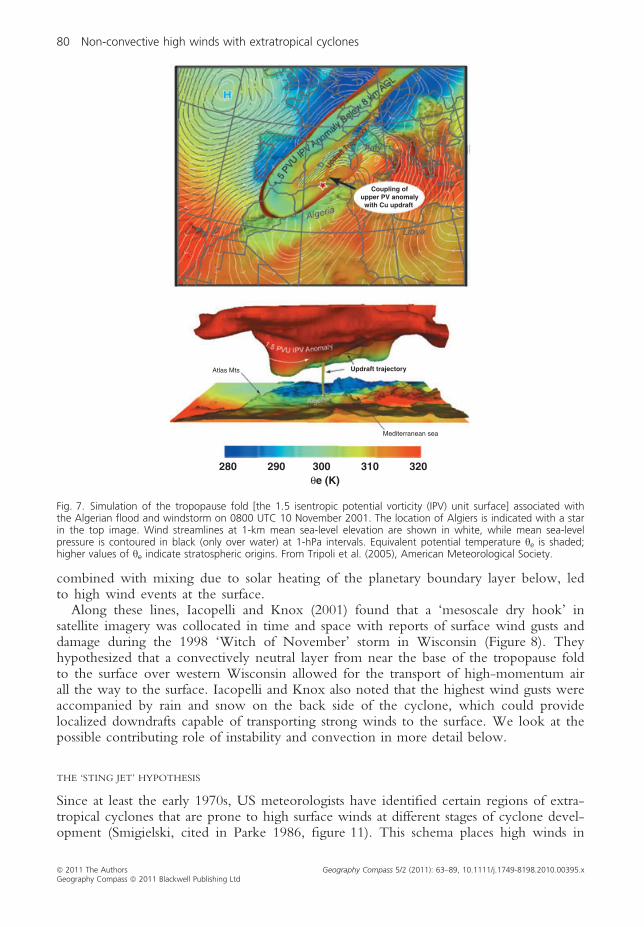
Fig. 7. Simulation of the tropopause fold [the 1.5 isentropic potential vorticity (IPV) unit surface] associated withthe Algerian flood and windstorm on 0800 UTC 10 November 2001. The location of Algiers is indicated with a starin the top image. Wind streamlines at 1-km mean sea-level elevation are shown in white, while mean sea-levelpressure is contoured in black (only over water) at 1-hPa intervals. Equivalent potential temperature he is shaded;higher values of he indicate stratospheric origins. From Tripoli et al. (2005), American Meteorological Society.
80 Non-convective high winds with extratropical cyclones
ª 2011 The Authors Geography Compass 5/2 (2011): 63–89, 10.1111/j.1749-8198.2010.00395.xGeography Compass ª 2011 Blackwell Publishing Ltd

the southern semicircle of the occluded low centre at its maximum intensity. Later,Grønas (1995) described in more detail a similar pattern in relation to the marine frontalcyclone conceptual model of Shapiro and Keyser (1990), in which the traditional occludedfront is replaced with a bent-back warm front and warm seclusion. Noting the occurrenceof a low-level jet on the outer side of the seclusion in a very intense Norwegian cyclonein January 1992, Grønas referred to this region of high wind as ‘the poisonous tail’ ofthe bent-back front, recalling his own forecasting experiences in Norway in the late1960s.
In the past decade, research in Europe on non-convective high wind events hascoalesced around this feature, which Browning (2004) has memorably labelled the ‘stingjet’ in analogy with the sting of a scorpion’s tail. In his article, Browning analysed theOctober 1987 ‘Great Storm’ observationally and inferred the presence of multiple bandedstructures in a hooked cloud head tip which were associated with high wind gusts.Browning (2004) concluded that ‘upright and slantwise convection … may have played arole in the local enhancement of the already strong winds’ – the enhancement leading toa sting jet. This work coincided with observational research by Reid and Vaughan (2004)indicating the ability of convection to mix stratospheric and boundary-layer air rapidly.In a follow-up article to Browning (2004), Clark et al. (2005) analysed high-resolutionoperational model output and confirmed the association between slantwise circulationsand a sting jet descending from 650 hPa, beneath the dry intrusion rather than directlyassociated with it. Clark et al. distinguished between the sting jet and the warm and coldconveyor belts of the cyclone, noting differences in both location and altitude (Figure 9).
Fig. 8. GOES-8 Imager water vapour satellite imagery of the ‘Witch of November’ non-convective high wind eventat 0015 UTC 11 November 1998. Radiances bracketing 240 K have been darkened to emphasize the ‘mesoscaledry hook’ in the upper troposphere over eastern Wisconsin. Wind gust reports (in knots) at 0000 UTC are con-toured, highlighting the collocation of the mesoscale dry hook and highest surface wind gusts. From Iacopelli andKnox (2001).
Non-convective high winds with extratropical cyclones 81
ª 2011 The Authors Geography Compass 5/2 (2011): 63–89, 10.1111/j.1749-8198.2010.00395.xGeography Compass ª 2011 Blackwell Publishing Ltd

Recently, Parton et al. (2009) provided direct observations of sting jet winds in themid-troposphere gleaned from an October 2002 cyclone whose cloud tip passed directlyover a wind profiler site in Wales. Their observations and complementary modelling sim-ulations confirmed the existence of a sting jet in a marine cyclone exhibiting a bent-backwarm front. The sting jet was associated with vertical circulations compatible withslantwise convection caused by conditional symmetric instability (CSI; Schultz andSchumacher 1999). Baker (2009) has also presented evidence of a sting jet in the intense‘Gudrun’ ⁄ ‘Erwin’ cyclone in the northern UK in January 2005, although in this case thesting jet was not responsible for the strongest low-level winds. However, the applicabilityof the sting jet hypothesis is so far limited to marine cyclones.
Past and Future Trends in Non-Convective High Wind Occurrences
Extreme winds are a very active area of research with regard to climate change.Because the rapid pace of work quickly renders any review obsolete, and in light of the
(a) (b)
(c) (d)
Fig. 9. Conceptual model of the near-surface flows in a marine extratropical cyclone, emphasizing the sting jet (SJ,in red). (a) Early stage of frontal wave cyclone development. L denotes low-pressure centre with direction of move-ment shown by thin arrow. Grey arrows show the storm-relative low-level jets; WCB is the warm-conveyor-belt jetand CCB is the cold conveyor-belt jet. (b) Frontal fracture phase, when the sting jet first appears at the surface. (c)As the cloud head wraps around the cyclone, the SJ region extends. (d) Eventually the SJ disappears and the domi-nant low-level wind in this region is due to the CCB. Modified from Clark et al. (2005), ªCrown copyright 2005,the Met Office.
82 Non-convective high winds with extratropical cyclones
ª 2011 The Authors Geography Compass 5/2 (2011): 63–89, 10.1111/j.1749-8198.2010.00395.xGeography Compass ª 2011 Blackwell Publishing Ltd

considerable uncertainties associated with this subject in both the past and future, welimit the discussion here to a brief overview.
Instrumental and documentary evidence of storminess along the Atlantic coast ofwestern Europe (Clarke and Rendell 2009 and references therein; see also Hanna et al.2008) implies more or less unchanged patterns of high winds in this region over thepast 150 years. However, other work (Paciorek et al. 2002) has revealed significantupward trends in extreme winds in both the north Atlantic and north Pacific basinsfrom 1950 to 2000. Angel and Isard (1998) found that strong cyclones with centralpressures £992 hPa more than doubled in frequency in the US Great Lakes regionfrom 1900 to 1990, presumably leading to stronger winds. McCabe et al. (2001)subsequently obtained results similar to Angel and Isard’s for the Northern Hemispheremid-latitudes from 1959 to 1997. In the Southern Hemisphere, fewer but largerextratropical cyclones have formed in the mid-latitudes since the 1950s, and have beenmore intense in some regions, particularly to the south of Australia (Simmonds andKeay 2000).
Firm conclusions are not yet possible with regard to future predictions of extremewinds. Della-Marta et al. (2008), surveying a range of modelling results, stated that ‘confi-dence in future wind-storm changes is low, although it seems likely … [according toIPCC] that there will be an increase in extreme winds over the north Atlantic and centralEurope’. On the one hand, modelling studies such as Leckebusch et al. (2006) and Knip-pertz et al. (2000) have projected significant increases in the occurrence of extreme windsover parts of Europe, especially northwest Europe, during the 21st century. Theseextremes would be associated with a higher frequency of more intense extratropicalcyclones (Leckebusch et al. 2006, figure 10) and would occur southward of centres ofchanging extreme cyclone activity, consistent with the location of non-convective highwinds discussed in the previous section. On the other hand, Pryor et al. (2006), usingdownscaling techniques, found no substantial changes in near-surface wind speeds in the21st century for northern Europe. In short, there is great uncertainty regarding futuretrends in non-convective high winds.
In the event that high winds become more common and more extreme in the future,the implications for society could be significant. Leckebusch et al. (2007), using the samemodelling results as Leckebusch et al. (2006), estimated that storm-related losses to theUK and Germany could increase by up to 37% due to a greater number of extremewindstorms. Insurance-industry estimates of wind damage associated with climate changeare somewhat lower, but are still in the billions of dollars per year in the UK alone (Asso-ciation of British Insurers 2009).
An important factor in any such estimate is the increasing vulnerability due to risingpopulation and development in the paths of these winds. As Pielke and Landsea (1998)and Pielke et al. (2008) have shown with regard to hurricanes in the USA, steep upwardtrends in damage can be attributed to these societal factors, not to changes in thefrequency and intensity of the meteorological phenomenon itself. Thus, even in theabsence of an increase in non-convective high winds, the human cost from these eventscould rise sharply in the future.
Conclusion and Avenues for Future Work
Non-convective high winds associated with extratropical cyclones occur across the globe.They cause fatalities and property damage on scales rivalling other, often better-knownweather phenomena. It is our hope that this review article places non-convective high
Non-convective high winds with extratropical cyclones 83
ª 2011 The Authors Geography Compass 5/2 (2011): 63–89, 10.1111/j.1749-8198.2010.00395.xGeography Compass ª 2011 Blackwell Publishing Ltd

wind events in broader conceptual and geographical frameworks, bridging artificial cul-tural and scientific divides.
These events exhibit relatively consistent patterns in climatologies and case studies,from the persistence of southwest quadrant winds in the US Great Lakes to the collo-cation of highest winds with the tip of the comma cloud in European ‘sting jet’ cases.However, to date no one physical mechanism has been identified as causing non-convec-tive high winds. Several different near-surface and mid-to-upper-tropospheric processeshave been proposed, with the sting jet hypothesis gaining the most attention andmomentum in recent years in the analysis of European marine cyclones.
There is some evidence for increased extreme winds associated with extratropicalcyclones during the past half-century. Some, but not all, analyses of future climate projectincreased frequency and intensity of high wind events during the next century, due tochanges in extratropical cyclone characteristics in a globally warmed world. Confidencein these predictions is low. If the predictions verify, however, the societal consequencescould be very significant – especially given the increased societal vulnerability due to ris-ing population and development.
Future research should benefit from bridging the artificial divides noted above. Onesuch divide is between the climatological work carried out on non-convective highwinds in North America and the many recent case studies of such events in Europe.Intercomparison of the research performed on both sides of the Atlantic may bear addi-tional fruit. For example, the schematic for sting jets in Figure 9 seems to suggest astrong preference for south-through-west non-convective high winds, as found by Lackeet al. (2007) for the US Great Lakes region. Does this suggest that many or most suchevents in the Great Lakes are in fact sting jets? The Shapiro–Keyser cyclone model wasdeveloped for marine cyclones, not continental cyclones, and warm seclusions are notcommon in inland cyclones. But it is true that in at least one case, the Great Lakes haveinduced hurricane-like characteristics in an extratropical cyclone (Miner et al. 2000).Thus, the possible generalization of the sting jet hypothesis to other regions outside ofEurope, and the cross-fertilization of climatological and case-study research on this sub-ject are two promising avenues for future work. Additional research to elucidate the stingjet ⁄CSI relationship, and to determine the relative importance of CSI versus other pro-cesses such as evaporative cooling, is also likely to clarify our understanding of theseevents.
Another area for future work that is currently being explored (Durkee et al. forth-coming) involves the quantitative comparison of different mechanisms for causing non-convective high winds. If no one mechanism is dominant in every instance, then itshould be useful for researchers and forecasters alike to be able to differentiate betweenevents that are, for example, primarily low-level and isallobaric in nature versus thosewith significant contributions from vertical advective processes (e.g. subsidence, tropo-pause folds, and ⁄or sting jets).
With regard to trends in non-convective high wind events, a high priority for futureresearch should be resolving conflicting results from general circulation model simulationsand downscaling techniques. Additional palaeoclimate research using proxies for windmay also shed some light on past trends in extratropical cyclones and high winds duringchanging climatic conditions.
Pursuit of these avenues for future work should improve our understanding and forecast-ing of non-convective high winds. These improvements, we hope, will lessen the tragicconsequences for those who find themselves, like the crew of the Edmund Fitzgerald, ‘in theface of a hurricane west wind’.
84 Non-convective high winds with extratropical cyclones
ª 2011 The Authors Geography Compass 5/2 (2011): 63–89, 10.1111/j.1749-8198.2010.00395.xGeography Compass ª 2011 Blackwell Publishing Ltd
Acknowledgement
We would like to thank the authors whose work is cited in this review article; Dr Tho-mas Mote for his efforts as Section Editor; Phil Kurimski and Alan Black for commentson an early draft of the manuscript; Prof. Andrew Lambert of King’s College London forinformation on the Great Storm of 1854; and the anonymous referees whose commentsimproved the manuscript.
Short Biographies
John Knox is an assistant professor of geography in the atmospheric sciences program atthe University of Georgia (UGA) in Athens, Georgia. His research interests focus onatmospheric and climate dynamics, including non-convective high winds, clear-air turbu-lence forecasting and inertial instability. Knox’s research has been funded by NSF,NOAA and NASA and has appeared in leading atmospheric science journals. Knoxreceived the 2010 T. Theodore Fujita Research Achievement Award from the NationalWeather Association. He is also the co-author of the award-winning introductorycollege-level textbook Meteorology: Understanding the Atmosphere (2007). Prior to comingto UGA, Knox taught at Barnard College and Valparaiso University. He received a BS inmathematics from the University of Alabama at Birmingham and earned a PhD in atmo-spheric sciences from the University of Wisconsin-Madison, and was a post-doctoral fel-low at Columbia University in conjunction with the NASA ⁄Goddard Institute for SpaceStudies.
John Frye is an assistant professor of Geography at Kutztown University of Pennsylvania.His research interests are land surface–atmosphere interactions, weather impacts onsociety, climate variability, and remote sensing applications in meteorology andclimatology. His research has been published in Journal of Applied Meteorology andClimatology, Monthly Weather Review, Journal of Climate, and Theoretical and AppliedClimatology. He earned a BS in journalism and an MS in geography from Ball StateUniversity and a PhD in geography from the University of Georgia.
Joshua Durkee is an assistant professor in the meteorology program at Western Ken-tucky University’s Department of Geography and Geology. He received a BS in geogra-phy from Western Kentucky University, and MS and PhD degrees in geography fromthe University of Georgia. His research interests include synoptic and mesoscale meteo-rology ⁄ climatology, hydroclimatology, atmospheric circulation and teleconnections,remote sensing and GIS applications in the atmospheric sciences, and education assess-ment and reform in the atmospheric sciences.
Christopher Fuhrmann is Research Climatologist for the NOAA-Southeast RegionalClimate Center and doctoral candidate in Geography at the University of North Carolina-Chapel Hill. His research interests are in synoptic climatology, weather and society, climateand human health, winter weather, and climate variability and change. He holds a BA ingeography from UNC-Chapel Hill and an MS in geography from the University of Georgia.
Note
* Correspondence address: Dr John A. Knox, Department of Geography, University of Georgia, 210 Field Street,Athens, GA 30602, USA. E-mail: [email protected].
Non-convective high winds with extratropical cyclones 85
ª 2011 The Authors Geography Compass 5/2 (2011): 63–89, 10.1111/j.1749-8198.2010.00395.xGeography Compass ª 2011 Blackwell Publishing Ltd

References
Abrams, M. H., et al. (eds) (1979). The Norton anthology of English literature, vol. 1. 4th ed. New York: W.W. Nor-ton and Company.
Ackerman, S. A. and Knox, J. A. (2007). Meteorology: understanding the atmosphere. 2nd ed. Belmont, CA: Brooks ⁄Cole.
Angel, J. R. (1996). Cyclone climatology of the Great Lakes. Publication 172. Champaign, IL: Midwestern RegionalClimate Center.
Angel, J. R. and Isard, S. A. (1997). An observational study of the influence of the Great Lakes on the speed andintensity of passing cyclones. Monthly Weather Review 125, pp. 2228–2237.
Angel, J. R. and Isard, S. A. (1998). The frequency and intensity of Great Lake cyclones. Journal of Climate 11, pp.61–71.
Ashley, W. S. and Black, A. W. (2008). Fatalities associated with nonconvective high wind events in the UnitedStates. Journal of Applied Meteorology and Climatology 47, pp. 717–725.
Association of British Insurers (2009). The financial risks of climate change. [Online]. Retrieved on 19 November 2010from: http://www.abi.org.uk/Publications/ABI_Publications_The_Financial_Risks_of_Climate_Change_59e.aspx.
Baker, L. (2009). Sting jets in severe northern European wind storms. Weather 64, pp. 143–148.Beven, J. L., et al. (2008). Atlantic hurricane season of 2005. Monthly Weather Review 136, pp. 1109–1173.Blackburn, T. (1978). The phenomenal storm of January 25–26, 1978. National Weather Digest 3 (2), pp. 20–26.Brown, D. G. (2002). White Hurricane: a Great Lakes November gale and America’s deadliest maritime disaster. Camden,
ME: International Marine ⁄ McGraw Hill.Browning, K. A. (1997). The dry intrusion perspective of extra-tropical cyclone development. Meteorological Applica-
tions 4, pp. 317–324, doi:10.1017/S1350482797000613.Browning, K. A. (1999). Mesoscale aspects of extratropical cyclones: an observational perspective. In: Shapiro, M.
A. and Grønas, S. (eds) The life cycles of extratropical cyclones. Boston, MA: American Meteorological Society,pp. 265–283.
Browning, K. A. (2004). The sting at the end of the tail: damaging winds associated with extratropical cyclones.Quarterly Journal of the Royal Meteorological Society 130, pp. 375–399.
Browning, K. A. and Reynolds, R. (1994). Diagnostic study of a narrow cold-frontal rainband and severe windsassociated with a stratospheric intrusion. Quarterly Journal of the Royal Meteorological Society 120, pp. 235–257.
Buckley, B. W. and Leslie, L. M. (2000). The Australian Boxing Day storm of 1998 – synoptic description andnumerical simulations. Weather and Forecasting 15, pp. 543–558.
Burt, S. D. and Mansfield, D. A. (1988). The Great Storm of 15–16 October 1987. Weather 43, pp. 90–114.Clark, P. A., Browning, K. A. and Wang, C. (2005). The sting at the end of the tail: model diagnostics of the
fine-scale 3D structure of the cloud head. Quarterly Journal of the Royal Meteorological Society 131, pp. 2263–2292.Clarke, M. L. and Rendell, H. M. (2009). The impact of North Atlantic storminess on western European coasts: a
review. Quaternary International 195, pp. 31–41.Cox, J. D. (2002). Storm watchers: the turbulent history of weather prediction from Franklin’s kite to El Nino. Hoboken,
NJ: John Wiley & Sons.Crupi, K. M. (2004). An anomalous non-convective high wind episode over Upper Michigan. National Weather
Digest 28, pp. 3–12.Davis, R. E. and Dolan, R. (1992). The ‘‘All Hallows Eve’’ coastal storm: October 1991. Journal of Coastal Research
8, pp. 978–983.Deedler, W. R. (2005a). Great Lakes White Hurricane: November 1913. [Online]. Retrieved on 29 November 2009
from: http://www.crh.noaa.gov/dtx/stm_1913.php.Deedler, W. R. (2005b). A great storm is upon Michigan: the Great Blizzard of 1978. [Online]. Retrieved on 30
November 2009 from: http://www.crh.noaa.gov/dtx/stories/blizzard1978.php.Della-Marta, P. M., et al. (2008). The return period of wind storms over Europe. International Journal of Climatology
29, pp. 437–459.Desplanque, C. and Mossman, D. J. (1999). Storm tides of Fundy. Geographical Review 89, pp. 23–35.Dolan, R. (1987). The Ash Wednesday Storm of 1962: 25 years later. Journal of Coastal Research 3, pp. 2–6.Durkee, J. D., Fuhrmann, C. F., Knox, J. A. and Frye, J. D. (forthcoming). Ageostrophic contributions to a
non-convective high wind event in the Great Lakes region. National Weather Digest.Feren, G. (1990). Climatology of storms in eastern Bass Strait. Internal Bureau of Meteorology Technical Report.
Melbourne, Vic., Australia: Bureau of Meteorology.Fink, A. H., et al. (2009). The European storm Kyrill in January 2007: synoptic evolution, meteorological impacts
and some considerations with respect to climate change. Natural Hazards and Earth System Sciences 9, pp. 405–423.
Forsythe, W., Breen, C., Callaghan, C. and McConkey, R. (2000). Historic storms and shipwrecks in Ireland: apreliminary survey of severe synoptic conditions as a causal factor in underwater archaeology. International Journalof Nautical Archaeology 29, pp. 247–259.
86 Non-convective high winds with extratropical cyclones
ª 2011 The Authors Geography Compass 5/2 (2011): 63–89, 10.1111/j.1749-8198.2010.00395.xGeography Compass ª 2011 Blackwell Publishing Ltd
Glickman, T. (ed.) (2000). Glossary of meteorology. 2nd ed. American Meteorological Society. [Online]. Retrievedon 13 December 2009 from: http://amsglossary.allenpress.com/glossary.
Goering, M. A., Gallus, W. A., Olsen, M. A. and Stanford, J. L. (2001). Role of stratospheric air in a severeweather event: analysis of potential vorticity and total ozone. Journal of Geophysical Research 106, pp. 11813–11823.
Grønas, S. (1995). The seclusion intensification of the New Year’s Day storm 1992. Tellus 47, pp. 733–746.Hakim, G. J., Bosart, L. F. and Keyser, D. (1995). The Ohio Valley wave-merger cyclogenesis event of January
25–26, 1978. Part I: multiscale case study. Monthly Weather Review 123, pp. 2663–2692.Hanna, E., et al. (2008). New insights into North European and North Atlantic surface pressure variability, stormi-
ness, and related climatic change since 1830. Journal of Climate 21, pp. 6739–6766.Haurwitz, B. (1946). On the relation between the wind field and pressure changes. Journal of Meteorology 3, pp.
95–99.Hill, H. W. (1970). The precipitation in New Zealand associated with the cyclone of early April 1968. New Zealand
Journal of Science 13, pp. 641–662.Holden, T. (1991). Lake Superior’s wicked November storms. Mariners Weather Log 35, pp. 4–11.Holton, J. R. (2004). An introduction to dynamic meteorology. 4th ed. New York: Academic Press.Homar, V., Ramis, C. and Alonso, S. (2002). A deep cyclone of African origin over the western Mediterranean:
diagnosis and numerical simulation. Annales Geophysicae 20, pp. 93–106.Hoskins, B. J. and Pedder, M. A. (1980). The diagnosis of middle latitude synoptic development. Quarterly Journal
of the Royal Meteorological Society 106, pp. 707–719.Hultquist, T. R., Dutter, M. R. and Schwab, D. J. (2006). A re-examination of the 9–10 November 1975
‘‘Edmund Fitzgerald’’ storm using today’s technology. Bulletin of the American Meteorological Society 87, pp. 607–622.
Iacopelli, A. J. and Knox, J. A. (2001). Mesoscale dynamics of the record-breaking 10 November 1998 mid-latitudecyclone: a satellite-based case study. National Weather Digest 25 (1,2), pp. 33–42.
Junger, S. (1997). The perfect storm: a true story of men against the sea. New York: W.W. Norton and Company.Kapela, A. F., Leftwich, P. W. and Van Ess, R. (1995). Forecasting the impacts of strong wintertime post-cold
front winds in the northern Plains. Weather and Forecasting 10, pp. 229–244.Kean, T. (2003). Witches of November. Frederick, MD: Publish America.Kistler, R. E., Uccellini, L. and Kocin, P. J. (2004). Thanksgiving Weekend Storm of 1950. Paper presented at the
Norm Phillips Symposium, Annual Meeting of the American Meteorological Society, Seattle, WA, 15 January2004.
Knippertz, P., Ulbrich, U. and Speth, P. (2000). Changing cyclones and surface wind speeds over the North Atlan-tic and Europe in a transient GHG experiment. Climate Research 15, pp. 109–122.
Knox, J. A. and Ackerman, S. A. (1996). Teaching the extratropical cyclone with the Edmund Fitzgerald storm. Paperpresented at the 5th Symposium on Education, American Meteorological Society, Atlanta, GA, 31 January 1996.
Kocin, P. J. and Uccellini, L. W. (2004). Northeast snowstorms – vol. II: the cases. Meteorological Monograph No.54. Boston, MA: American Meteorological Society.
Kocin, P. J., Schumacher, P. N., Morales, R. F. and Uccellini, L. W. (1995). Overview of the 12–14 March 1993Superstorm. Bulletin of the American Meteorological Society 76, pp. 165–182.
Kwon, H. J. and Lim, G. H. (1999). Reexamination of the structure of the ageostrophic wind in baroclinic waves.Journal of the Atmospheric Sciences 56, pp. 2512–2521.
Lacke, M. C., et al. (2007). A climatology of cold-season nonconvective wind events in the Great Lakes region.Journal of Climate 20, pp. 6012–6022.
Lamb, H. and Frydendahl, K. (1991). Historic storms of the North Sea, British Isles, and Northwest Europe. Cambridge:Cambridge University Press.
Leckebusch, G. C., et al. (2006). Analysis of frequency and intensity of winter storm events in Europe on synopticand regional scales from a multi-model perspective. Climate Research 31, pp. 59–74.
Leckebusch, G. C., Ulbrich, U., Frolich, L. and Pinto, J. G. (2007). Property loss potentials for European midlati-tude storms in a changing climate. Geophysical Research Letters 34, pp. L05703, doi:10.1029/2006GL027663.
Lewis, P. J. (1987). Severe storms over the Great Lakes: a catalogue summary for the period 1957–1985. Downsview, ON,Canada: Canadian Climate Center, Atmospheric Environment Service.
Lynch, A. H., Cassano, E. N., Cassano, J. J. and Lestak, L. R. (2003). Case studies of high wind events in Barrow,Alaska: climatological context and development processes. Monthly Weather Review 131, pp. 719–732.
Martin, J. and Konrad, C. E. (2006). Directional characteristics of potentially damaging wind gusts in the SoutheastUnited States. Physical Geography 27, pp. 155–169.
Mass, C. and Dotson, B. (2010). Major extratropical cyclones of the Northwest United States. Part I: historicalreview, climatology, and synoptic environment. Monthly Weather Review, 138, pp. 2499–2527.
McCabe, G. J., Clark, M. P. and Serreze, M. C. (2001). Trends in Northern Hemisphere surface cyclone frequencyand intensity. Journal of Climate 14, pp. 2763–2768.
McKee, A. (2000). The golden wreck: the tragedy of the ‘Royal Charter’. Flintshire, UK: Avid Publications.
Non-convective high winds with extratropical cyclones 87
ª 2011 The Authors Geography Compass 5/2 (2011): 63–89, 10.1111/j.1749-8198.2010.00395.xGeography Compass ª 2011 Blackwell Publishing Ltd

Miner, T., Sousounis, P. J., Wallman, J. and Mann, G. (2000). Hurricane Huron. Bulletin of the American MeteorologicalSociety 81, pp. 223–236.
Mundle, R. (1999). Fatal Storm: the inside story of the tragic Sydney-Hobart race. Camden, ME: International Mari-ne ⁄ McGraw Hill.
National Climatic Data Center (1978). Storm data, vol. 20, no. 2. Asheville, NC: National Climatic Data Center, 9pp.
National Climatic Data Center (2005). State of the climate – global hazards – August 2005. [Online]. Retrieved on 13December 2009 from: http://www.ncdc.noaa.gov/sotc/index.php?report=hazards&year=2005&month=aug.
Niziol, T. A. and Paone, T. J. (2000). A climatology of non-convective high wind events in western New York state. NOAATechnical Memorandum, NWS ER-91. [Online]. Retrieved on 12 December 2009 from: http://www.erh.noaa.gov/er/hq/ssd/erps/tm/tm91.pdf.
Paciorek, C. J., Risbey, J. S., Ventura, V. and Rosen, R. D. (2002). Multiple indices of Northern Hemispherecyclone activity, winters 1949–99. Journal of Climate 15, pp. 1573–1590.
Padgett, G., Boyle, K., Chunliang, H. and Clarke, S. (2005). Monthly global tropical cyclone summary – August, 2005.[Online]. Retrieved on 19 November 2010 from: http://australiasevereweather.com/cyclones/2006/summ0508.htm.
Parke, P. S. (ed.) (1986). Satellite imagery interpretation for forecasters. NOAA ⁄ National Weather Service ForecastingHandbook No. 6. Washington, DC: NOAA/National Weather Service.
Parton, G. A., et al. (2009). Wind profiler observations of a sting jet. Quarterly Journal of the Royal Meteorological Soci-ety 135, pp. 663–680.
Pauley, P. M., Baker, N. L. and Barker, E. H. (1996). An observational study of the ‘‘Interstate 5’’ dust storm case.Bulletin of the American Meteorological Society 77, pp. 693–720.
Pearce, R., Lloyd, D. and McConnell, D. (2001). The post-Christmas ‘French’ storms of 1999. Weather 56, pp.81–91.
Pedgley, D. E. (1997). The Fastnet storm of 1979: a mesoscale surface jet. Weather 52, pp. 230–242.Phillips, N. A. (1958). Geostrophic errors in predicting the Appalachian Storm of November 1950. Geophysica 6,
pp. 389–405.Pielke, R. A., Jr and Landsea, C. W. (1998). Normalized hurricane damage in the United States: 1925–95. Weather
and Forecasting 13, pp. 621–631.Pielke, R. A., Jr, et al. (2008). Normalized hurricane damage in the United States: 1900–2005. Natural Hazards
Review 9, pp. 29–42.Pryor, S. C., Schoof, J. T. and Barthelmie, R. J. (2006). Winds of change?: projections of near-surface winds under
climate change scenarios. Geophysical Research Letters 33, L11702 pp. doi:10.1029/2006GL026000.Read, W. (2004). The January 9, 1880 ‘‘Storm King’’. [Online]. Retrieved on 12 December 2009 from: http://
www.climate.washington.edu/stormking/January1880.html.Read, W. (2005). The ‘‘Big Blow’’ of Columbus Day 1962. [Online]. Retrieved on 12 December 2009 from: http://
www.climate.washington.edu/stormking/October1962.html.Reed, R. J., et al. (2001). Analysis and modeling of a tropical-like cyclone in the Mediterranean Sea. Meteorology
and Atmospheric Physics 76, pp. 183–201.Reid, H. J. and Vaughan, G. (2004). Convective mixing in a tropopause fold. Quarterly Journal of the Royal Meteoro-
logical Society 130, pp. 1195–1212.Richwien, B. A. (1980). Isallobaric contribution to a ship’s sinking. Paper presented at the 8th Conference on Weather
Forecasting and Analysis, American Meteorological Society, Denver, CO, 10 June 1980.Rousmaniere, J. (1980). Fastnet: force 10. New York: W.W. Norton and Company.Salmon, E. M. and Smith, P. J. (1980). A synoptic analysis of the 25–26 January 1978 blizzard cyclone in the cen-
tral United States. Bulletin of the American Meteorological Society 61, pp. 453–460.Schuepp, M., et al. (1994). The winterstorm ‘‘Vivian’’ of 27 February 1990: about the meteorological development,
wind forces and damage situation in the forests of Switzerland. Theoretical and Applied Climatology 49, pp. 183–200.Schultz, D. M. and Schumacher, P. N. (1999). The use and misuse of conditional symmetric instability. Monthly
Weather Review 127, pp. 2709–2732.Schultz, J. and Meisner, B. (2009). The 24 February 2007 north Texas dust storm: an impact weather event.
National Weather Digest 33, pp. 165–184.Shapiro, M. A. and Keyser, D. (1990). Fronts, jet streams and the tropopause. In: Newton, C. W. and Holopainen,
E. O. (eds) Extratropical cyclones: the Eric Palmen memorial volume. Boston, MA: American Meteorological Society,pp. 167–191.
Shaw, W. B. (1983). Tropical cyclones: determinants of pattern and structure in New Zealand’s indigenous forests.Pacific Science 37, pp. 405–414.
Shields, L. and Fitzgerald, D. (1989). The ‘Night of the Big Wind’ in Ireland, 6–7 January 1839. Irish Geography22, pp. 31–43.
Simmonds, I. and Keay, K. (2000). Variability of Southern Hemisphere extratropical cyclone behavior, 1958–97.Journal of Climate 13, pp. 550–561.
88 Non-convective high winds with extratropical cyclones
ª 2011 The Authors Geography Compass 5/2 (2011): 63–89, 10.1111/j.1749-8198.2010.00395.xGeography Compass ª 2011 Blackwell Publishing Ltd

Smith, C. D. (1950). The destructive storm of November 25–27, 1950. Monthly Weather Review 78, pp. 204–209.Sterl, A., et al. (2009). An ensemble study of extreme storm surge related water levels in the North Sea in a chang-
ing climate. Ocean Science 5, pp. 369–378.Stonehouse, F. (1977). The wreck of the Edmund Fitzgerald. Gwinn, MI: Avery Color Studios, Inc.Stoppkotte, E. M., Lese, A., Pavlow, S. and Baker, R. (2009). 14 September 2008 Ohio Valley high wind event associ-
ated with the remnants of Hurricane Ike. Paper presented at the 23rd Conference on Weather Analysis and Forecast-ing ⁄ 19th Conference on Numerical Weather Prediction, American Meteorological Society, Omaha, NE, 4 June2009.
Sweeny, J. (2000). A three-century storm climatology for Dublin 1715–2000. Irish Geography 33, pp. 1–14.Tripoli, G. J., et al. (2005). The 9–10 November 2001 Algerian flood: a numerical study. Bulletin of the American
Meteorological Society 86, pp. 1229–1235.Uccellini, L. W. (1990). Processes contributing to the rapid development of extratropical cyclones. In: Newton, C. W.
and Holopainen, E. O. (eds) Extratropical cyclones: the Eric Palmen memorial volume. Boston, MA: American Meteoro-logical Society, pp. 81–105.
Ulbrich, U., Fink, A. H., Klawa, M. and Pinto, J. G. (2001). Three extreme storms over Europe in December1999. Weather 56, pp. 70–80.
Von Ahn, J., Sienkiewicz, J. and McFadden, G. (2005). Hurricane force extratropical cyclones observed usingQuickSCAT near real time winds. Mariners Weather Log 49 (1) April. [Online]. Retrieved on 12 December 2009from: http://www.vos.noaa.gov/MWL/april_05/cyclones.shtml.
Wagner, A. J. (1978). Weather and circulation of January 1978 – cold with record snowfall in the Midwest andNortheast, mild and wet in the West. Monthly Weather Review 106, pp. 579–585.
Wernli, H., Dirren, S., Liniger, M. A. and Zillig, M. (2002). Dynamical aspects of the life-cycle of the winterstorm ‘‘Lothar’’ (24–26 December 1999). Quarterly Journal of the Royal Meteorological Society 128, pp. 405–429.
Wheeler, D. (2003). The Great Storm of 1703: a new look at the seamen’s records. Weather 58, pp. 419–427.Yarovaya, D. A., et al. (2008). A quasitropical cyclone over the Black Sea: observations and numerical simulation.
Physical Oceanography 18, pp. 154–167.
Non-convective high winds with extratropical cyclones 89
ª 2011 The Authors Geography Compass 5/2 (2011): 63–89, 10.1111/j.1749-8198.2010.00395.xGeography Compass ª 2011 Blackwell Publishing Ltd