Embed Size (px)
Citation preview

ISSN 2152-7237 (print)ISSN 2153-2060 (online)
The
Silk RoadVolume 8 2010
“The Bridge between Eastern and Western Cultures”
Contents
From the Editor’s Desktop ................................................................... 3
Images from Ancient Iran: Selected Treasures from the National Museum in Tehran. A Photographic Essay ............................................................... 4
Ancient Uighur Mausolea Discovered in Mongolia, by Ayudai Ochir, Tserendorj Odbaatar, Batsuuri Ankhbayar and Lhagwasüren Erdenebold .......................................................................................... 16
The Hydraulic Systems in Turfan (Xinjiang),by Arnaud Bertrand ................................................................................. 27
New Evidence about Composite Bows and Their Arrows in Inner Asia,by Michaela R. Reisinger .......................................................................... 42
An Experiment in Studying the Felt Carpet from Noyon uul by theMethod of Polypolarization, by V. E. Kulikov, E. Iu. Mednikova, Iu. I. Elikhina and Sergei S. Miniaev .................... 63
The Old Curiosity Shop in Khotan,by Daniel C. Waugh and Ursula Sims-Williams ................................................. 69
Nomads and Settlement: New Perspectives in the Archaeology of Mongolia,by Daniel C. Waugh ................................................................................ 97
(continued)
The Silk Road is an annual publication of the Silkroad Foundation supplied in a limited print run to librar-ies. We cannot accept individual subscriptions. Each issue can be viewed and downloaded free of charge at: <http://www.silkroadfoundation.org/toc/newsletter.html>. The print version contains black and white illus-trations; the online version uses color. Otherwise the content is identical. Please feel free to contact us with any questions or contributions. Information regarding contributions and how to format them may be found on the website at <http://www.silkroadfoundation.org/newsletter/vol8/SilkRoadinstructionsforauthors.pdf>.
The Silkroad Foundation Editor: Daniel C. Waugh 14510 Big Basin Way # 269 [email protected], CA 95070
© 2010 Silkroad Foundation© 2010 by authors of individual articles and holders of copyright, as specifi ed, to individual images.
Book notices (except as noted, by Daniel C. Waugh)
The University of Bonn’s Contributions to Asian Archaeology ................................ 125
John E. Hill. Through the Jade Gate to Rome .................................................. 127
Elfriede Regina Knauer. Coats, Queens, and Cormorants .................................... 128
Yuka Kadoi. Islamic Chinoiserie. The Art of Mongol Iran .................................... 130
Susan Whitfi eld, ed. La Route de la Soie ....................................................... 132
Johan Elverskog. Buddhism and Islam on the Silk Road ..................................... 133
Khotan is Hot: Journal of Inner Asian Art and Archaeology 3 (2008); Bulletin of the Asia Institute 19 (2005 [2009]) .................................................................... 135
John Becker, in collaboration with Donald B. Wagner. Pattern and Loom (reviewed by Sandra Whitman) ............................................................ 137
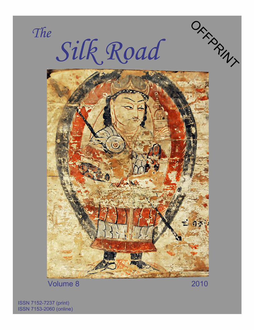
Cover photo: Vaiśravana, detail of plaque acquired in Khotan by Clarmont Skrine in 1922. British Museum 1925,619.35. Reproduced with permission of the Trustees of the British Museum. Photo copyright © 2010 Daniel C. Waugh. The complete plaque is reproduced in Susan Whitfi eld and Ursula Sims-Williams, eds., The Silk Road: Trade, Travel, War and Faith. Chicago: Serindia, 2004, p. 160, no. 60, but misnumbered as
1925,619.25.
2

Daniel C. WaughUniversity of Washington (Seattle)
The “archaeology of mobility” in recent years has moved quite far from traditional approaches to the study of “nomadic”
societies (Archaeology 2008, reviewed in Waugh 2009; Social Complexity 2009; Houle and Erdenebaatar 2009). Instead of the seemingly antithetical poles of the “steppe and the sown,” most work nowadays emphasizes a continuum where mobility and settlement and the economies of the populations involved in them may be mixed in varying degrees. We no longer think of “pure nomadism” of the type that most of the earliest written sources, produced in sedentary societies, describe with reference to the “barbarian” other. The methodologies underlying some of the new interpretive approaches are still very much in the process of development, which may be one reason that the newer perspectives on “nomadism” have not yet had the broad impact they deserve on the more general treatments of pre-modern Eurasian history. While I cannot encompass all of the methodologies, I hope that a selective review of this literature will be of some value both to specialists and the general reader. Such a review reveals how much information there is on settlements in the pre-modern steppe regions, at the same time that it reminds us how slim the foundations of that knowledge yet are and how rapidly our understanding of it is changing. At very least we might conclude that sweeping generalizations, based on older perceptions about the nature of nomadic societies, should be abandoned, even if it is premature to arrive at a new synthesis.
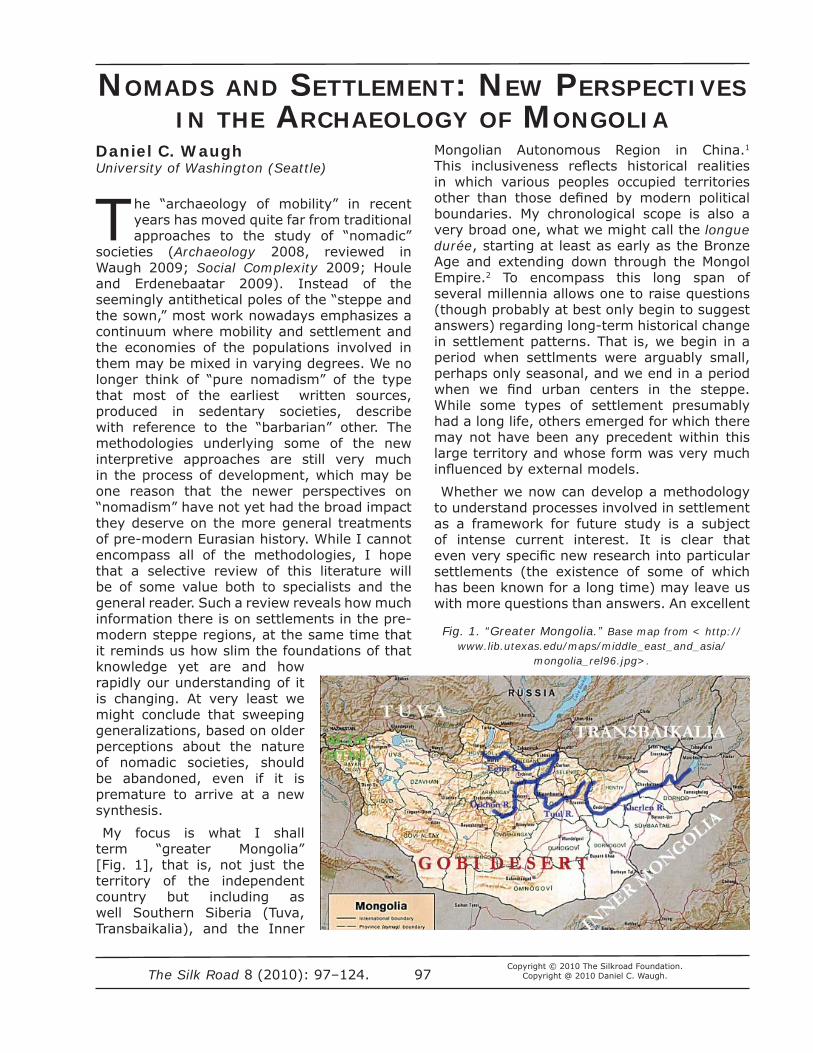
My focus is what I shall term “greater Mongolia” [Fig. 1], that is, not just the territory of the independent country but including as well Southern Siberia (Tuva, Transbaikalia), and the Inner
NOMADS AND SETTLEMENT: NEW PERSPECTIVES IN THE ARCHAEOLOGY OF MONGOLIA
Mongolian Autonomous Region in China.1 This inclusiveness refl ects historical realities in which various peoples occupied territories other than those defi ned by modern political boundaries. My chronological scope is also a very broad one, what we might call the longue durée, starting at least as early as the Bronze Age and extending down through the Mongol Empire.2 To encompass this long span of several millennia allows one to raise questions (though probably at best only begin to suggest answers) regarding long-term historical change in settlement patterns. That is, we begin in a period when settlments were arguably small, perhaps only seasonal, and we end in a period when we fi nd urban centers in the steppe. While some types of settlement presumably had a long life, others emerged for which there may not have been any precedent within this large territory and whose form was very much infl uenced by external models.
Whether we now can develop a methodology to understand processes involved in settlement as a framework for future study is a subject of intense current interest. It is clear that even very specifi c new research into particular settlements (the existence of some of which has been known for a long time) may leave us with more questions than answers. An excellent
Fig. 1. “Greater Mongolia.” Base map from < http://www.lib.utexas.edu/maps/middle_east_and_asia/
mongolia_rel96.jpg>.
The Silk Road 8 (2010): 97–124.Copyright © 2010 The Silkroad Foundation.
Copyright @ 2010 Daniel C. Waugh.97
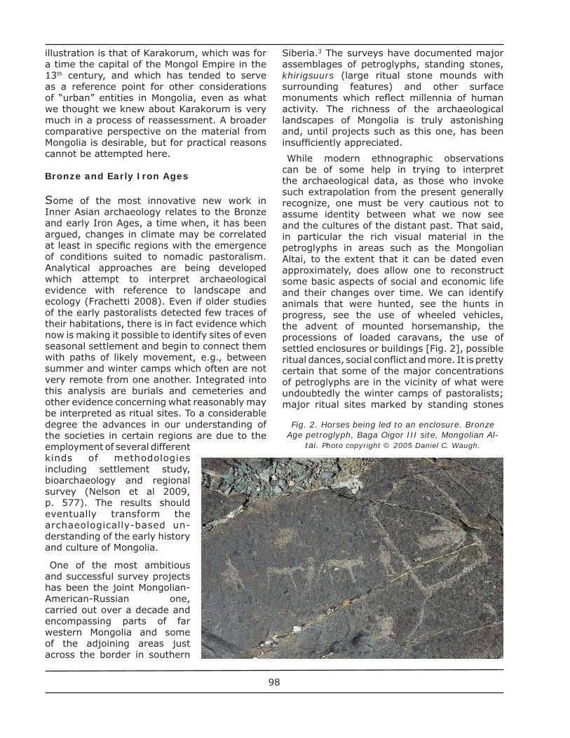
illustration is that of Karakorum, which was for a time the capital of the Mongol Empire in the 13th century, and which has tended to serve as a reference point for other considerations of “urban” entities in Mongolia, even as what we thought we knew about Karakorum is very much in a process of reassessment. A broader comparative perspective on the material from Mongolia is desirable, but for practical reasons cannot be attempted here.
Bronze and Early Iron Ages
Some of the most innovative new work in Inner Asian archaeology relates to the Bronze and early Iron Ages, a time when, it has been argued, changes in climate may be correlated at least in specifi c regions with the emergence of conditions suited to nomadic pastoralism. Analytical approaches are being developed which attempt to interpret archaeological evidence with reference to landscape and ecology (Frachetti 2008). Even if older studies of the early pastoralists detected few traces of their habitations, there is in fact evidence which now is making it possible to identify sites of even seasonal settlement and begin to connect them with paths of likely movement, e.g., between summer and winter camps which often are not very remote from one another. Integrated into this analysis are burials and cemeteries and other evidence concerning what reasonably may be interpreted as ritual sites. To a considerable degree the advances in our understanding of the societies in certain regions are due to the employment of several different kinds of methodologies including settlement study, bioarchaeology and regional survey (Nelson et al 2009, p. 577). The results should eventually transform the archaeologically-based un-derstanding of the early history and culture of Mongolia.
One of the most ambitious and successful survey projects has been the joint Mongolian-American-Russian one, carried out over a decade and encompassing parts of far western Mongolia and some of the adjoining areas just across the border in southern
Siberia.3 The surveys have documented major assemblages of petroglyphs, standing stones, khirigsuurs (large ritual stone mounds with surrounding features) and other surface monuments which refl ect millennia of human activity. The richness of the archaeological landscapes of Mongolia is truly astonishing and, until projects such as this one, has been insuffi ciently appreciated.
While modern ethnographic observations can be of some help in trying to interpret the archaeological data, as those who invoke such extrapolation from the present generally recognize, one must be very cautious not to assume identity between what we now see and the cultures of the distant past. That said, in particular the rich visual material in the petroglyphs in areas such as the Mongolian Altai, to the extent that it can be dated even approximately, does allow one to reconstruct some basic aspects of social and economic life and their changes over time. We can identify animals that were hunted, see the hunts in progress, see the use of wheeled vehicles, the advent of mounted horsemanship, the processions of loaded caravans, the use of settled enclosures or buildings [Fig. 2], possible ritual dances, social confl ict and more. It is pretty certain that some of the major concentrations of petroglyphs are in the vicinity of what were undoubtedly the winter camps of pastoralists; major ritual sites marked by standing stones
Fig. 2. Horses being led to an enclosure. Bronze Age petroglyph, Baga Oigor III site, Mongolian Al-
tai. Photo copyright © 2005 Daniel C. Waugh.
98
or khirigsuurs must have been ones which were visited on a regular basis. The pastoralists did not simply move through an area and never return; some part of their annual cycle involved a settled existence; one can certainly speak of central places in their lives (Houle 2009, p. 365). How the peoples who left these surface monuments viewed their surroundings can be conjectured on the basis of the imagery, the positioning of the monuments in the surrounding landscape, and other kinds of data. The rich surface documentation extends at least down through the Turkic and Uighur periods of the 6th–9th centuries, at which time image stones with depictions of people become a common feature (and can be found later as well).
In the area of this major survey project, excavation of ritual sites or graves is still at an early stage. Thus our knowledge of the material culture of the peoples and clues about their identities is still limited. However, there is good reason to believe that those who inhabited the Mongolian Altai are related to those who lived in some of the archaeologically better documented areas across the mountains in, say, southern Siberia. Moreover, identifi cation of settlement sites has proved to be diffi cult, even if some of the ritual features include what may be characterized as “dwellings” at least in the symbolic sense of space delineated by stones which might be understood to resemble an enclosure or house.
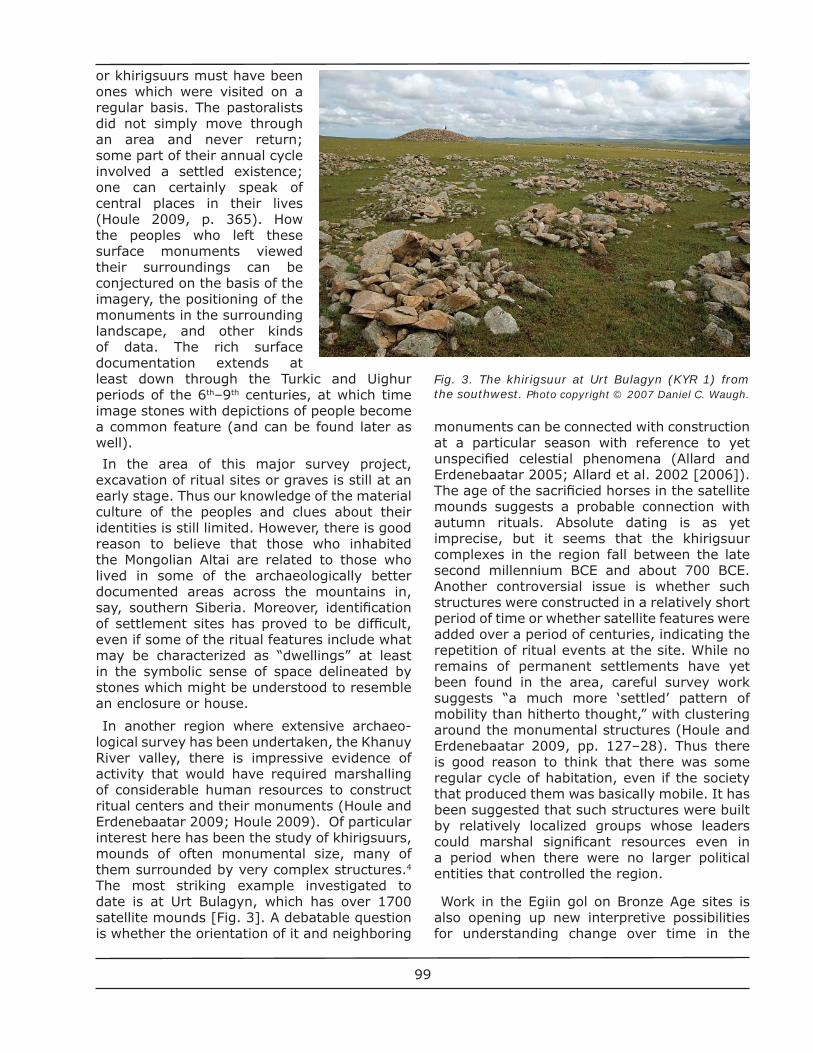
In another region where extensive archaeo-logical survey has been undertaken, the Khanuy River valley, there is impressive evidence of activity that would have required marshalling of considerable human resources to construct ritual centers and their monuments (Houle and Erdenebaatar 2009; Houle 2009). Of particular interest here has been the study of khirigsuurs, mounds of often monumental size, many of them surrounded by very complex structures.4 The most striking example investigated to date is at Urt Bulagyn, which has over 1700 satellite mounds [Fig. 3]. A debatable question is whether the orientation of it and neighboring
monuments can be connected with construction at a particular season with reference to yet unspecifi ed celestial phenomena (Allard and Erdenebaatar 2005; Allard et al. 2002 [2006]). The age of the sacrifi cied horses in the satellite mounds suggests a probable connection with autumn rituals. Absolute dating is as yet imprecise, but it seems that the khirigsuur complexes in the region fall between the late second millennium BCE and about 700 BCE. Another controversial issue is whether such structures were constructed in a relatively short period of time or whether satellite features were added over a period of centuries, indicating the repetition of ritual events at the site. While no remains of permanent settlements have yet been found in the area, careful survey work suggests “a much more ‘settled’ pattern of mobility than hitherto thought,” with clustering around the monumental structures (Houle and Erdenebaatar 2009, pp. 127–28). Thus there is good reason to think that there was some regular cycle of habitation, even if the society that produced them was basically mobile. It has been suggested that such structures were built by relatively localized groups whose leaders could marshal signifi cant resources even in a period when there were no larger political entities that controlled the region.
Work in the Egiin gol on Bronze Age sites is also opening up new interpretive possibilities for understanding change over time in the
Fig. 3. The khirigsuur at Urt Bulagyn (KYR 1) from the southwest. Photo copyright © 2007 Daniel C. Waugh.
99
societies that constructed them (Honeychurch et al. 2009). The evidence about chronology is still limited, and the excavations are so few as to leave open questions about the statistical sample. Yet it does seem possible to suggest correlations between the nature and distribution of the sites and social change and the possible relationship of these changes to the development of interactions over long distances, facilitated by the introduction of horse riding.
The Xiongnu
We fi rst encounter walled settlement sites in our larger Mongolia in the period of the Xiongnu, who emerged as a major polity around 200 BCE and continued to play an important role in Eurasia at least into the middle of the second century CE. Xiongnu archaeology has attracted a great deal of attention. Apart from a range of cemetery excavations encompassing both elite and ordinary burials, there have been excavations at a few settlements. The fi rst of these to be thoroughly studied are in Buriatia, south of Lake Baikal. Best known is Ivolga, a settlement which had a quadruple wall and may have housed as many as 3000 inhabitants (Davydova 1988, 1995, 1996).5 At least some of the population lived in semi-dugout houses (a kind of construction found in other areas of Siberia down into modern times), ones which are distinctive in their having heating fl ues under benches around the inside of the building. Such heating systems, known from the Bohai Culture of northern Korea and Manchuria but possibly of Han Dynasty Chinese inspiration, are also to be found centuries later in some of the urban sites in Mongolia. The Ivolga site has yielded many artifacts, including evidence that at least part of the local
diet consisted of grains, possibly some of them grown locally. The abundance of iron artifacts and pottery of often impressive dimensions and solidity in Xiongnu sites surely points to there having been possibilities for signifi cant local production, which would of itself suggest that at least portions of Xiongnu society were settled during part of the year. Thus, the picture in the Chinese annals of a largely nomadic society cannot be entirely accurate. Yes, as abundant archaeological evidence indicates, horse breeding was important in the society, the Xiongnu were mobile (we even have a sketch of one of their camps with several trellis tents in it), but we cannot be certain exactly what the role of a settlement like Ivolga was (see, e.g., Kradin 2001, esp. p. 80).
Another Xiongnu settlement, at Boroo Gol, within 25 km of the Noyon uul cemeteries in the mountains of north-central Mongolia, has strikingly similar features to those at Ivolga (Ramseyer et al. 2009; Pousaz and Turbat 2008). Possibly Boroo Gol is to be connected with gold-working in its adjoining region, but yet uncertain is whether it “was a permanent or a seasonal” village. Another of the unresolved questions concerns chronology, since preliminary data for one house dates it between 320 and 200 BCE, whereas for another house, the date range is 80–250 CE. One can only speculate on the possible relationship of the site to the cemeteries at Noyon uul.
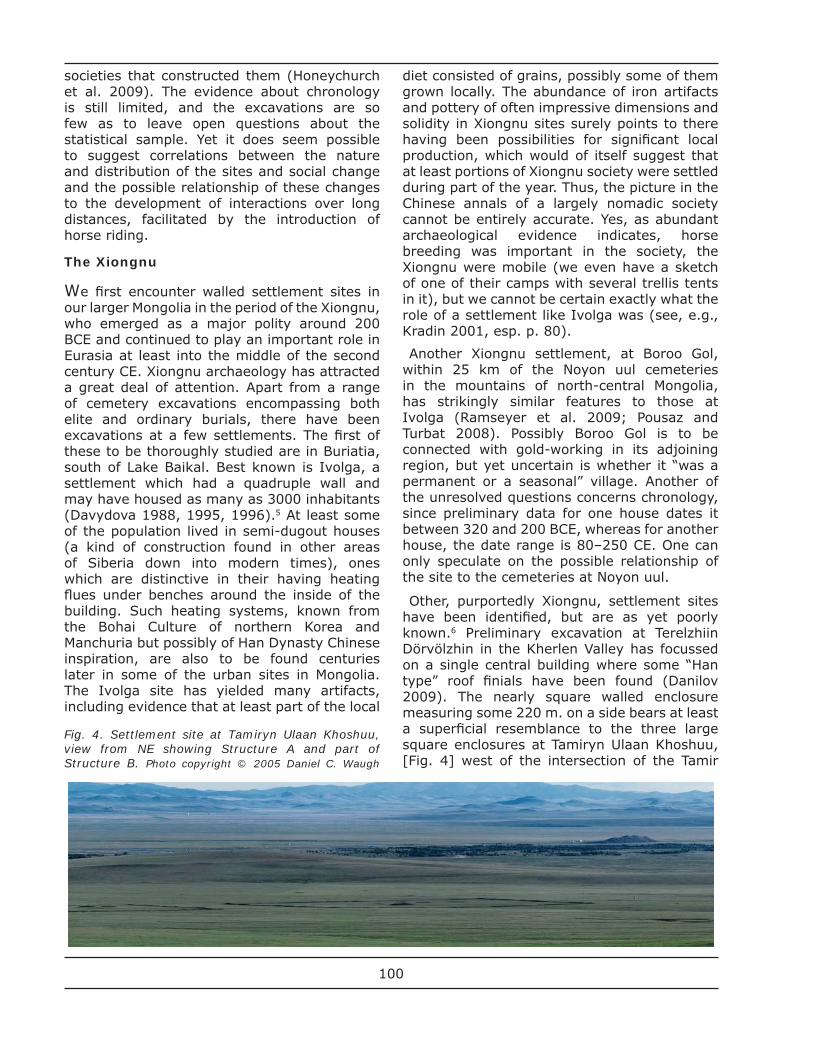
Other, purportedly Xiongnu, settlement sites have been identifi ed, but are as yet poorly known.6 Preliminary excavation at Terelzhiin Dörvölzhin in the Kherlen Valley has focussed on a single central building where some “Han type” roof fi nials have been found (Danilov 2009). The nearly square walled enclosure measuring some 220 m. on a side bears at least a superfi cial resemblance to the three large square enclosures at Tamiryn Ulaan Khoshuu, [Fig. 4] west of the intersection of the Tamir
Fig. 4. Settlement site at Tamiryn Ulaan Khoshuu, view from NE showing Structure A and part of Structure B. Photo copyright © 2005 Daniel C. Waugh
100
and Orkhon rivers (Purcell and Spurr 2006, esp. pp. 27–31). Yet to date we cannot even be certain those are from the Xiongnu period. To study properly such large sites (and for that matter, any other sizeable settlements) will be a major undertaking, especially where there may be relatively few structural remains beyond the walls themselves.
Where there are cemeteries adjoining the settlements (the one substantially studied example is at Ivolga), we might hope to establish something about the identity of their populations. Yet to date there seems to be little unequivocal evidence. At present, it seems safest to propose that the Xiongnu polity encompassed a mixed population, with some Mongoloid (northeast Asian) and some Caucasoid members. Too much of what has been written on this subject is based on cranial metrics; there is so far little DNA testing. As Christine Lee notes, “both of these methodologies have serious issues” (Lee 2009).
Not the least of the challenges in learning about the Xiongnu is to establish a clear chronology of sites across the whole area of what at one or another time was considered to be part of the Xiongnu polity.7 As yet we know little about Xiongnu sites in what is now Inner Mongolia, some of which might be presumed to be “early” given what some posit concerning Xiongnu origins. Xiongu-period burials at the Baga Gazaryn Chuluu site in the Mongolian Gobi may be as early as the 2nd century BCE (the period of the presumed greatest fl ourishing of the Xiongnu polity) (Nelson et al. 2009). We still have no clear sense of the impact of the Han Dynasty’s aggressive moves against the Xiongnu and reestablishment of some control over its northern frontiers, which may have shifted the center of the Xiongnu polity and possibly then changed the nature of its built environment. As Ursula Brosseder has recently suggested, such monumental structures as the Xiongnu terrace tombs may be a “late” phenomenon, from a period when the Xiongnu polity was under considerable stress (Brosseder 2009).
Of particular interest if we are to understand better the evidence from various periods regarding settlements in pre-modern Mongolia is the project which has been underway in the Egiin Gol Valley of north-central Mongolia. As its authors state, the study emphasizes
“the importance of a long-term perspective on mobile pastoralism that allows us to see shifts in strategy and in productive scale from local networks to those involving expanded territories, larger groups, and urban centers.” (Honeychurch and Amartüvshin 2007, p. 56; also idem (2002) 2006; Honeychurch et al. 2009). The methodologies applied here might well be applied to other areas where to date the focus has been on localized excavation without suffi cient study of surrounding landscapes and their resource potential for supporting human habitation. The survey work in the Egiin gol in effect worked from two chronological directions. For assessing the productive potential of the area’s varied ecology for pastoralism and agriculture, it was necessary to study contemporary practices and recent historic data. This then provided the basis, granted, on a still rather hypothetical level, for correlating productive potential with the location of archaeological sites dating from the Bronze Age (or even earlier) down through the Xiongnu and Uighur periods. Of particular interest here is evidence suggesting a growing emphasis on agriculture in the Xiongnu period, possibly to be understood as refl ecting resource management in the time of the developing centralized Xiongnu polity, but then the apparent decline in the interest in agriculture in the Egiin gol in the Uighur period. This decline might be related to the emergence of true urban centers amongst the Uighurs in the valleys to the west of the Egiin gol, where towns were surrounded by extensive agriculture and seem to have served as focal points around which the Uighur elite courts and retinue moved on a regular basis. While the focus of the Egiin gol study is not to analyze this urban development, its authors conclude with stimulating suggestions about the relationship between nomadic pastoralists and urban centers: “The nature of the steppe city and its relationship to a mobile hinterland was an entirely novel form of ‘central place’ innovated by steppe nomads specifi cally for negotiating a mobile sociopolitical and economic context” (Honeychurch and Amartüvshin 2007, p. 58). If we accept this view, we may in fact arrive at a much better understanding of the functions of the urban centers than we have had to date.
One of the larger issues here concerns the mechanisms for the emergence of “nomadic empires” and the degree to which they
101
may or may not have depended on external stimuli for their development. While possibly the differences in the interpretive stances here have been exaggerated, in a somewhat simplifi ed form, the confl icting interpretations are represented by Thomas Barfi eld, who emphasizes the external factors and persistent patterns, and Nicola Di Cosmo, who emphasizes internal ones and evolutionary change. The work on Egiin gol supports the position of Di Cosmo, as does a recent attempt to survey and classify the types of urban settlements in Mongolia from the Uighur through the Mongol period.8
One of the major gaps in our knowledge of settlements in greater Mongolia is for the period between the Xiongnu and the Uighurs, that is from about the second to about the eighth centuries CE. Of particular signifi cance is the fact that we still have such limited archaeological knowledge of groups such as the Xianbei, who replaced the Xiongnu in certain areas.9 One can at best hypothesize regarding their socio-economic transformation accompanying their presumed movement west and south from a homeland in northeast Asia into the steppe region. It would be dangerous to attempt to read back from the better documented history of the Northern Wei, their successors who established an important state in Northern China in the late 4th century. Written sources suggest that there were large migrations and substantial settlements at, for example, Shengle (in today’s Inner Mongolia just south of Hohhot). The Northern Wei seem to have had a number of fortifi ed centers (protecting themselves against incursions by newly emergent threats on their northern frontiers). Yet even a site as important as Shengle is little known, despite its long history of settlement both antedating and postdating its brief existence as the Northern Wei capital. Very quickly the Northern Wei moved their capital over the mountains to the south, where their orientation was no longer in the fi rst instance to the steppe world but rather to sedentary China (Dien 2007, esp. pp. 15–32; Steinhardt 1990, pp. 91, 78–87). While this is a period when we can see the spread northwards of a Chinese imperial model of city planning, how we might best interpret the processes of its assimilation remains an open question. Given the complicated patterns of interactions across “borders” in this frontier zone, and in the absence of major excavation of important
urban centers, there probably is little that can be established with certainty about the earliest layers of settlements along the northern frontiers, now overbuilt by the fortifi cations and buildings of later eras.
The Türks and the Uighurs
Of more immediate relevance to developments in Mongolia is the question of whether there are “urban” remains for the early Türk empire, which emerged in the second half of the sixth century CE, disintegrated about a century later, and then revived for some decades beginning in the late 7th century.10 Improbable as it may seem, what follows in the Uighur period, for which there is substantial evidence of urban development, would seem to have no precedent in the Turkic period. There are several very important Türk ritual sites commemorating various kaghans.11 These involved the building of platforms and pavilions, the carving of statues and the erection of large stele with inscriptions. There can be no question but that the 8th–century ritual site at Khöshöö–Tsaidam in the Orkhon River Valley was seen to be very signifi cant, placed in the heart of what the Türks considered to be their ancestral homeland. The texts on the stele at this and other sites provide for the fi rst time what we might consider to be the authentic “voice” of pastoralists in the Mongolian steppes. And what we fi nd in those texts is an explicit warning of the dangers of adopting sedentary ways and establishing urban centers. Yet there is as well evidence in the Chinese sources that the Türk ruler at one point requested from China resources to support agricultural development (Kiselev 1957, p. 93; Perlee 1957, p. 45). It would be an oversimplifi cation to conclude from this textual evidence that a process of “sedentarization” was already underway which should have left us more material evidence.
Apart from these dramatic and important ritual sites for the Turkic kaghans, there are numerous other Turkic memorial complexes involving carved statues, and arrays of stone fences and lines of standing stones scattered across the Eurasian steppes. Some of the best known concentrations are found in the Altai, but there is also important evidence of a Turkic presence on the northern edge of the Gobi (Jacobson-Tepfer et al. 2010 passim; Wright and Amartüvshin 2009). One can at
102
least surmise that, as with the Bronze Age ritual sites, these were ones which involved some kind of repeated visitation, perhaps on a regular basis. As Wright and Amartüvshin remind us, ceramic assemblages, such as those found at Baga Gazaryn Chuluu, “are equivalent to settlements” and they tend to cluster in the sheltered areas where modern observations confi rm pastoralists tend to establish their winter campsites. So there is in fact a rather broad range of data which can be brought to bear to establish mobility and settlement patterns for the early Türks.
The only sizeable walled enclosure of which I am aware which might be dated to the Türk period in Mongolia is Khukh Ordung on the eastern edge of the Khangai mountains, which border the Orkhon valley on the west. That is, this site is located to the southwest but across the valley and at some remove from the Khöshöö–Tsaidam site of the major Türk memorial complex. On the slimmest of grounds, Khukh Ordung, has been dated to the mid–7th century CE (at a time when the fi rst Turk empire had been destroyed), even though that date might well be merely a terminus post quem (cf. Kolbas 2005).12 There are structural features of Khukh Ordung which seem similar to those of the citadel at the later Uighur capital, Khar Balgas, but even if the site seems to be a Uighur one, to date it a century earlier than other Uighur sites seems premature, absent any serious excavation. That said, neither is there any reason to associate it with the revival of the Türk Empire in the area in the 8th century.
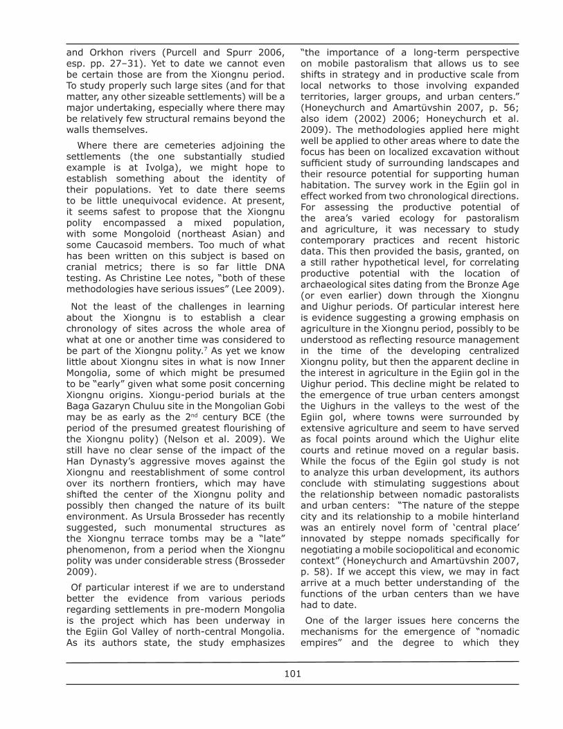
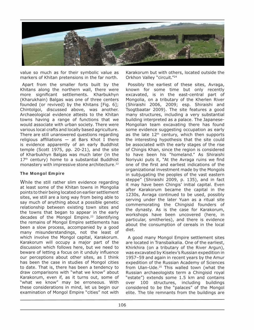
The roughly century-long period of Uighur power in Mongolia starting in the mid-8th century witnessed signifi cant construction of walled structures, some of which are only now being detected using sophisticated techniques of aerial photography and remote sensing (Bemmann and Ankhbayar 2010; Oczipka et al. 2009).13 At least one of these, a major city, has long been known, the Uighur capital Khar Balgas, whose ruins north of Karakorum on the fl ood plain of the Orkhon Valley can be
seen from kilometers away [Fig. 5]. While we now have a fairly good surface plan of Khar Balgas, and excavations have been undertaken there off and on for more than a century, we know precious little about the site beyond the fortifi ed “palace complex.”14 The walls of the latter are of tamped earth; however, at least in the crumbling “citadel” in the southeast corner, there are very substantial grey fi red bricks. Outside the large walled enclosure of the “palace,” which can be seen from afar across the valley, are lower walled enclosures and the remains of an extensive settlement, which, allegedly, is to be dated to the same time as the walled palace complex. We cannot be certain whether the Uighurs built atop a previous settlement here or what, exactly, followed on their being driven out by the Kyrgyz in the middle of the 9th century. There seems to be good reason to think that the Kyrgyz did not themselves occupy the Orkhon but rather went back to their homelands in the upper Enisei River basin (Drompp 1999). When the Mongol successors of Chingis Khan built Karakorum, they studied the Khar Balgas site, even if they were apparently mystifi ed as to what it had been.
Khar Balgas is the rare case of a “city in the steppe” for which in the period prior to the Mongol Empire we have a contemporary description by a foreign visitor. Tamim ibn-Bahr, the representative of the Abbassid Caliph in 821, described a huge city surrounded by extensive settlements and agriculture, all of which seems to correspond to what we so far know based on archaeology (Minorsky 1948, esp. 283). However, his description really is quite limited and problematic, given the fact that his written account compresses so much of the journey. One cannot be entirely confi dent that his descriptions of productive agriculture, whose existence is entirely probable, really relate to the Orkhon valley or to some place much further to the west.
Fig. 5. Khar Balgas, view of citadel from south. Photo copyright © 2007 Daniel C. Waugh.
103
The Orkhon Valley is also the location of a number of Uighur burial and ritual sites (durvuljin) employing some of the same techniques of construction found at Khar Balgas, which may have served as a source of building materials. Several of these durvuljin have been excavated (see Ochir et al. 2010, published above, pp. 16–26). Their builders used fi red brick to create vaulted entrance passages and domed burial chambers, and in one instance so far uncovered, painted murals on plaster to decorate the tomb. One important fi nding of these excavations is that such sites may contain layers extending back as far as the Xiongnu period and then going down into the period of the Mongol Empire. When the Uighurs built one of their tombs, they must have known that the site previously had been used, even if they could not have been aware that the earlier burial was a Xiongnu one.
There are also Uighur sites farther north. Baibalyk is located on the Selenga River into which the Orkhon fl ows. There is written evidence that Chinese and Sogdians participated in its building.15 Whether the walled enclosures there served functions other than purely military and defensive is not clear, although stone lion sculptures have been excavated. Some of the most extensive evidence about Uighur settlements has been found across the borders from Mongolia in neighboring Tuva, where there are as many as a dozen fortifi ed enclosures, one as large as 230 m on a side and one a double-walled structure with an inner citadel.16 Both the architectural features and ceramic fi nds connect these sites with the Uighurs, whose effort to consolidate control in the upper Enisei valley beginning in the middle of the 8th century (soon after the time when Khar-Balgas was being built) is documented in written sources. In the fi rst instance, the Tuvan sites are forts, where probably the Uighur garrisons lived in their yurts; only one of the sites has remains of some structures in addition to the walls.
One of the most striking of the Tuvan sites is that at Por Bazhin, fi rst noticed by scholars in the late 19th century, excavated in 1957–63, and then beginning in 2007 the subject of renewed serious study in conjunction with efforts to preserve the site (Por Bazhin [2007]). It is a fortifi ed enclosure measuring 215 x 162 m. located on an island. The dating of the site to
the Uighur period is based so far mainly on its architectural analogies to Khar Balgas and from remains including roof tiles which are analogous to ones known from Tang China. It contains a number of structures, including what seems to have been a central ritual hall. As with a number of the other sites starting in the Uighur period, there is good reason to posit substantial Chinese “infl uence” on the architecture of the buildings at Por Bazhin — they included columned timber halls on platforms with ceramic tile roofs — but whether we should go so far as to agree they were the work of Chinese architects is a moot point. While it seems as though the construction materials were drawn from local sources, so far no evidence has been found of workshops, kilns, etc. which might be related to the work.
Not the least of the as yet unresolved puzzles about this site is what its function was. Apparently it was occupied for only a relatively short period of time, may have been used only in summer (there is no evidence suggesting there was a heating system), and may have served some religious or ritual purpose. There is, however, no direct evidence to suggest it was, say, a Buddhist temple or monastery. Its abandonment may have been connected with collapse of the short-lived fi rst Uighur empire, although at some perhaps later stage there is reason to think the site was severely damaged in an earthquake.
As with so much of the evidence about settlements and cities in Mongolia, we are left with more questions than answers about many of the Uighur sites, where not the least of the interpretive challenges involves the matter of agency. That is, what might we reasonably attribute to local initiative, or to what degree should we emphasize infl uence, simply because there is evidence of “cultural borrowing?” Annemarie von Gabain suggested that, given the close relationship between the Uighurs and the Tang Dynasty (which they saved from the An Lushan rebellion in the 8th century), Chinese wives of the Uighur rulers may have infl uenced the decision to build cities. This, in apparent contrast to the policies of the Turk kaghans, who were perhaps trying to hold Chinese infl uence at arm’s length. At the same time though, this is not to say that the Uighurs had made a full transition to settled urban life, something von Gabain posits occurred only later when the center of their state had moved
104
west to the Turfan region and they took over the major oasis cities that already existed there (Gabain 1950, p. 48). If we assume that the Uighur rulers followed the pattern of other nomadic leaders in establishing regular routes of movement to seasonal camps, we still need to learn more about what those routes may have been and whether the locations of sites identifi ed as being from the Uighur period in fact may be the remains of such seasonally occupied camps.
The Khitans
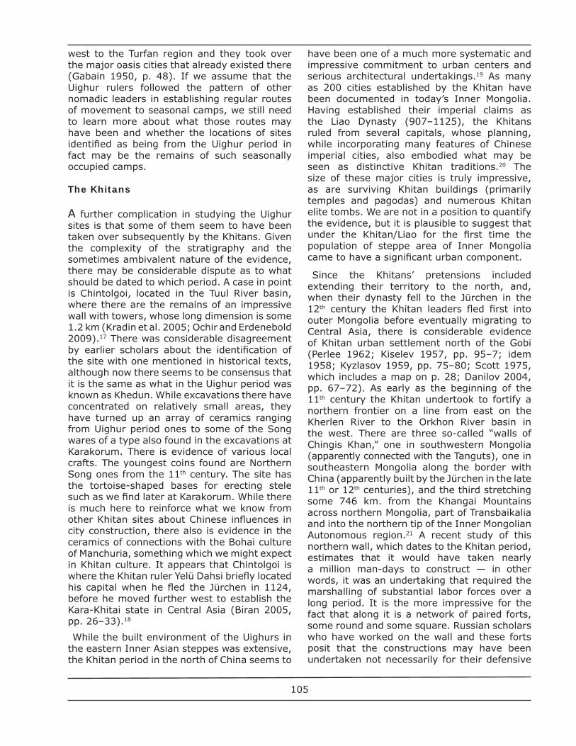
A further complication in studying the Uighur sites is that some of them seem to have been taken over subsequently by the Khitans. Given the complexity of the stratigraphy and the sometimes ambivalent nature of the evidence, there may be considerable dispute as to what should be dated to which period. A case in point is Chintolgoi, located in the Tuul River basin, where there are the remains of an impressive wall with towers, whose long dimension is some 1.2 km (Kradin et al. 2005; Ochir and Erdenebold 2009).17 There was considerable disagreement by earlier scholars about the identifi cation of the site with one mentioned in historical texts, although now there seems to be consensus that it is the same as what in the Uighur period was known as Khedun. While excavations there have concentrated on relatively small areas, they have turned up an array of ceramics ranging from Uighur period ones to some of the Song wares of a type also found in the excavations at Karakorum. There is evidence of various local crafts. The youngest coins found are Northern Song ones from the 11th century. The site has the tortoise-shaped bases for erecting stele such as we fi nd later at Karakorum. While there is much here to reinforce what we know from other Khitan sites about Chinese infl uences in city construction, there also is evidence in the ceramics of connections with the Bohai culture of Manchuria, something which we might expect in Khitan culture. It appears that Chintolgoi is where the Khitan ruler Yelü Dahsi briefl y located his capital when he fl ed the Jürchen in 1124, before he moved further west to establish the Kara-Khitai state in Central Asia (Biran 2005, pp. 26–33).18
While the built environment of the Uighurs in the eastern Inner Asian steppes was extensive, the Khitan period in the north of China seems to
have been one of a much more systematic and impressive commitment to urban centers and serious architectural undertakings.19 As many as 200 cities established by the Khitan have been documented in today’s Inner Mongolia. Having established their imperial claims as the Liao Dynasty (907–1125), the Khitans ruled from several capitals, whose planning, while incorporating many features of Chinese imperial cities, also embodied what may be seen as distinctive Khitan traditions.20 The size of these major cities is truly impressive, as are surviving Khitan buildings (primarily temples and pagodas) and numerous Khitan elite tombs. We are not in a position to quantify the evidence, but it is plausible to suggest that under the Khitan/Liao for the fi rst time the population of steppe area of Inner Mongolia came to have a signifi cant urban component.
Since the Khitans’ pretensions included extending their territory to the north, and, when their dynasty fell to the Jürchen in the 12th century the Khitan leaders fl ed fi rst into outer Mongolia before eventually migrating to Central Asia, there is considerable evidence of Khitan urban settlement north of the Gobi (Perlee 1962; Kiselev 1957, pp. 95–7; idem 1958; Kyzlasov 1959, pp. 75–80; Scott 1975, which includes a map on p. 28; Danilov 2004, pp. 67–72). As early as the beginning of the 11th century the Khitan undertook to fortify a northern frontier on a line from east on the Kherlen River to the Orkhon River basin in the west. There are three so-called “walls of Chingis Khan,” one in southwestern Mongolia (apparently connected with the Tanguts), one in southeastern Mongolia along the border with China (apparently built by the Jürchen in the late 11th or 12th centuries), and the third stretching some 746 km. from the Khangai Mountains across northern Mongolia, part of Transbaikalia and into the northern tip of the Inner Mongolian Autonomous region.21 A recent study of this northern wall, which dates to the Khitan period, estimates that it would have taken nearly a million man-days to construct — in other words, it was an undertaking that required the marshalling of substantial labor forces over a long period. It is the more impressive for the fact that along it is a network of paired forts, some round and some square. Russian scholars who have worked on the wall and these forts posit that the constructions may have been undertaken not necessarily for their defensive
105
value so much as for their symbolic value as markers of Khitan pretensions in the far north.
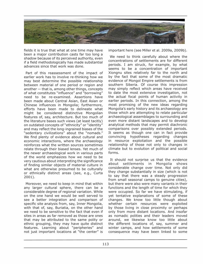
Apart from the smaller forts built by the Khitans along the northern wall, there were more signifi cant settlements. Kharbukhyn (Kharukhain) Balgas was one of three centers founded (or revived) by the Khitans [Fig. 6]; Chintolgoi, discussed above, was another. Archaeological evidence attests to the Khitan towns having a range of functions that we would associate with urban society. There were various local crafts and locally based agriculture. There are still unanswered questions regarding religious affi liations — at Bars Khot I there is evidence apparently of an early Buddhist temple (Scott 1975, pp. 20-21), and the site of Kharbukhyn Balgas was much later (in the 17th century) home to a substantial Buddhist monastery with impressive stone architecture.22
The Mongol Empire
While the still rather slim evidence regarding at least some of the Khitan towns in Mongolia points to their being located on earlier settlement sites, we still are a long way from being able to say much of anything about a possible genetic relationship between existing town sites and the towns that began to appear in the early decades of the Mongol Empire.23 Identifying the remains of Mongol Empire settlements has been a slow process, accompanied by a good many misunderstandings, not the least of which involve the Mongol capital, Karakorum. Karakorum will occupy a major part of the discussion which follows here, but we need to beware of letting a focus on it unduly infl uence our perceptions about other sites, as I think has been the case in studies of Mongol cities to date. That is, there has been a tendency to draw comparisons with “what we know” about Karakorum, even if, as it turns out, some of “what we know” may be erroneous. With these considerations in mind, let us begin our examination of Mongol Empire “cities” not with
Karakorum but with others, located outside the Orkhon Valley “circuit.”24
Possibly the earliest of these sites, Avraga, known for some time but only recently excavated, is in the east-central part of Mongolia, on a tributary of the Kherlen River (Shiraishi 2006, 2009; esp. Shiraishi and Tsogtbaatar 2009). The site features a good many structures, including a very substantial building interpreted as a palace. The Japanese-Mongolian team excavating there has found some evidence suggesting occupation as early as the late 12th century, which then supports the interesting hypothesis that the site could be associated with the early stages of the rise of Chingis Khan, since the region is considered to have been his “homeland.” As Shiraishi Noriyuki puts it, “At the Avraga ruins we fi nd one of the fi rst and earliest indications of the organizational investment made by the Mongols in subjugating the peoples of the vast eastern steppe” (Shiraishi 2009, p. 135), and in fact it may have been Chingis’ initial capital. Even after Karakorum became the capital in the 1230s, Avraga continued to be used, possibly serving under the later Yuan as a ritual site commemorating the Chingisid founders of the dynasty. As is the case for Karakorum, workshops have been uncovered (here, in particular, smitheries), and there is evidence about the consumption of cereals in the local diet.
A good many Mongol Empire settlement sites are located in Transbaikalia. One of the earliest, Khirkhira (on a tributary of the River Argun), was excavated by Kiselev’s Russian expedition in 1957–59 and again in recent years by the Amur expedition of the Russian Academy of Sciences from Ulan-Ude.25 This walled town (what the Russian archaeologists term a Chingisid royal “estate”) extends some 1.5 km and contains over 100 structures, including buildings considered to be the “palaces” of the Mongol elite. The tile remnants from the buildings are
106
similar to those found at other Mongol Empire sites but in particular most closely resemble those produced at sites in the Russian Far East. It is possible that there was an earlier (Uighur period) settlement at Khirkhira, although the structures which remain today suggest a date of the early 13th century (this is supported by a few radiocarbon dates), and then a short-lived period of occupation. Since the famous “Chingis Khan stone,” dated to around 1325 and with an inscription honoring Isunke, a nephew of Chingis Khan’s, was found near the Khirkhira site, the settlement has been associated with Isunke or his father Jöchi-Kosar and has been assigned the same date.
If Khirkhira and Avraga document Mongol control to the east, Dën-Terek documents Mongol power to the west in Tuva. The archaeologist and historian of Tuva, Leonid R. Kyzlasov (1965, esp. p. 60) emphasized that at the very beginning of the 13th century, extensive efforts at colonization followed the Mongol conquests there. As a result, at least fi ve major urban settlements were established, the earliest of which was Dën-Terek on the Elegest River, the administrative center for Tuva under the Mongols at the beginning of the 13th century. The site is a large one, some 1.2 km in length and occupying about 30 hectares, with over 120 structures. Like many of the Mongol Empire cities, it is unfortifi ed. The construction of the buildings so far excavated is substantial, with massive granite bases for wooden columns, and in the case of the “administrative” building, probably brick walls. There are many fragments of glazed roof tiles and pieces of sculpted dragons and phoenixes which probably decorated the roofs. At least some of the stuctures have underground heating ducts; it is probable that coal from a nearby mine served as the fuel. The occupants of the city engaged in a full range of economic undertakings, including the manufacture of ceramics and the processing of locally grown
agricultural products.
Kyzlasov’s proposed dating of the site to the Mongol Empire period in part is made with reference to the material the Russian expeditions unearthed at Karakorum (where the dating might well now be questioned). He relies rather heavily on conclusions about the style of the sculpted dragon heads, which he feels was typical for the late 12th and early 13th century, but differs from those found in the Yuan Dynasty period. There are no Yuan-period glazed ceramics at Dën-Terek. If these conclusions about the date of Dën-Terek are accurate, then the city either slightly antedates the founding of Karakorum or is roughly contemporaneous with it.
Karakorum
Naturally the goal of identifying the ruins of the Mongol capital, known from 13th-century written sources, guided the thinking of many early scholars who took an interest in Mongolian history.26 Even though for Karakorum we are far better served with written primary sources than we are for any previous city in Mongolia, relating the textual evidence to specifi c archaeological evidence is by no means easy. As Eva Becker has exhaustively demonstrated, the evidence in those written sources is largely quite equivocal, and too often unwarranted assumptions have been made on the basis of a misreading of them. Moreover, evidence from one of the most signifi cant early excavations at the site, by Dmitrii D. Bukinich in the 1930s, remained unpublished and tended to be ignored for political reasons. The result was that Sergei V. Kiselev’s excavations there in 1948–49 dominated much of what came to be known about the site for the remainder of the
Fig. 6. Kharbukhyn Balgas, approximately 270° panorama looking south taken from north wall of 17th-century monastic complex. Photo copyright © 2007 Daniel C. Waugh
107
20th century. The largest part of what has been arguably one of the most infl uential books on medieval Mongolian history, his co-authored Ancient Mongolian Cities (1965), concerns Karakorum. The book contains essays on the city’s history, the “palace,” mural fragments, the commercial and craft section of the city, coins, iron objects, ceramics, beads, leather objects, construction materials and miscellaneous crafts. Yet, even though much of this material retains its value, the archaeology on which all this was based was fundamentally fl awed.
While Kiselev deserves considerable praise precisely for emphasizing the importance of cities in pre-modern Mongolia, two important aspects of the presentation in the book are particularly troubling. For one, the interpretive framework is guided by a belief (which happens to be Marxist) in stages of historical development through which the Mongols inevitably must have passed. There is a concept here of “feudalism” which then requires that certain social and economic developments be found in the archaeological evidence, even if in a number of cases, Kiselev and his collaborators probably should have stopped short of generalizing conclusions.27 One can, of course, easily read through the interpretive verbiage, but then, if one does that, the second problem is much less easy to solve short of doing the kind of analysis Becker and the other German archaeologists have recently done. The fact is that Kiselev’s excavation methods were extremely sloppy and he seems deliberately to have ignored the import of some of the evidence. Thus we cannot rely on his observations about stratigraphy, which led him to conclude that the Karakorum he excavated was built on a previously existing site. This is as true for the commercial center of the city (at the “crossroads”) as it is for the so-called “palace” site. In general, observations about chronology in the Kiselev book need to be taken with caution, although this should hardly surprise us given the period in which his work was done and the signifi cant advances which have been made in dating techniques since then. While Kiselev insisted he had found evidence of an early layer of settlement at Karakorum, the careful stratigraphic analysis of the recent Mongolian–German expedition has shown that such was not the case.28 Assuming that there was an earlier Uighur fort on the site, it most likely encompassed the area of the current Erdene Zuu monastery and extended to
its east, not to the north in the area which was the subject of Kiselev’s excavations (Pohl 2009, pp. 527–30).
Karakorum is situated on a grassy plain a short distance from the Orkhon River where it emerges from the gorges of the Khantai Mountains and fl ows northward to meet the Tuul (on whose upper reaches the current capital of Mongolia, Ulaanbaatar, is located). A favorable micro-climate makes the location ideal for pasturage, and a Chinese traveler in 1247 remarked on the cultivation of grain and vegetables.29 Ata-Malik Juvayni, an important historian and offi cial under the Mongols, who spent time in Karakorum in the early 1250s, relates how hail destroyed the grain crop in one year, but the following one saw a bumper harvest (Juvayni 1958, I, pp. 226-227). Karakorum also is strategically located on the intersection of the important east-west and north-south routes across Mongolia. As we have seen above, this central part of the Orkhon River valley was considered a sacred homeland by steppe peoples such as the Turks and Uighurs who earlier had laid claim to universal dominion and had placed their capitals there. So the choice of the location for Karakorum was no accident: ecology, political considerations, steppe tradition and and local beliefs all came together there (Allsen 1996; Honeychurch and Amartüvshin 2006). We can be certain that the Mongols, having received the submission of the heirs to the earlier Uighurs, were highly conscious of the earlier history of the region, even if in some mythologized form, and, as Juvayni relates, must have been impressed by the still substantial remains of the Uighur capital of Khar Balgas.
Ironically, the physical remains of Karakorum itself would fare less well than those of Uighur Khar Balgas. There are few surface traces of the Mongol capital. One sees today a stone tortoise, cut in a local quarry, which served as the base for a plinth with an inscription on it. It stands near a mound, which, it turns out, is the foundation for a building whose identifi cation has attracted a great deal of attention (more on that shortly). Careful ground survey (even as early as the fi rst Russian expeditions of the 1890s) and now aerial photography and remote sensing have made possible mapping the outlines of an approximately rectangular city wall measuring about 1.5 x 2.5 km extending to the north of the current walls of the Erdene Zuu monastery, and
108
within it the shapes of a good many buildings (see Pohl 2009, esp. pp. 516–26). The walls were suffi cient for controlling access to the town but would not have protected it against a major attack. It was in the center of this area (the “crossroads”) that Kiselev focussed some of his attention and where, as it turned out, there is indeed evidence that this might have been the heart of a craftsman section of the town. The recent Mongolian–German excavations have determined that the oldest stratum here is from the early 13th century; the evidence in general seems to support a conclusion based on written sources that the serious development of the town really began under Khan Ögedei in the 1230s and 1240s, even if, perhaps, Chingis Khan was interested in the site somewhat earlier.
While it is diffi cult to match specifi cs with details in the written sources, the archaeological evidence fl eshes out their picture of the town’s economic life, with particularly rich material continuing to be found in the Chinese commercial section of the city, which has been the focus of both the Russian and the Mongolian–German excavations. Karakorum was a center of metallurgy where water power from a canal connecting the town with the Orkhon River ran the bellows for the forges. There are iron cauldrons (used, among other things, as heating braziers), abundant quantities of arrowheads, and various decorative metal objects. One workshop seems to have specialized in bronze casting; in another the excavations turned up a mould that was used to make a gold bracelet. Of particular interest are a substantial number of iron axle rings for carts, some of which must have been quite sizeable and presumably were used both for the transport of goods and at times to move gers without their being dismantled.30 Analogous carts are still used today in Mongolia. Local industry produced glass beads for jewelry and other decorative purposes; their forms are of a type that was widespread across all of the Mongol Empire. Spindle weights tell us that yarn was being produced — presumably in the fi rst instance from the wool of the Mongols’ own fl ocks. We know that rich silk fabrics were highly valued by the Mongol elite; some fragments of imported Chinese silk have been found.
Of particular interest is the production and importation of ceramics. One of the most striking discoveries of the recent Mongolian–German excavations was well preserved ceramic kilns,
which produced such objects as roof tiles and fi nials for the Chinese-style buildings, ceramic sculptures, and a variety of table ware.31 The evidence suggests that the kiln technology came from China. At the same time, the demand of the elite for high quality ceramic wares was met by imports, including good Chinese porcelain. When the famous blue-and-white porcelains began to be produced in large quantities in the fi rst half of the 14th century, they almost immediately found a market in Karakorum.
Evidence concerning commerce includes coinage. For all the fact that the written sources emphasize the signifi cant role of Muslim merchants connecting Karakorum with Central Asia, most of the coins which have been discovered are of Chinese origin and range in date from a few Tang Dynasty examples up through the Yuan (Mongol) coinage we would expect. However, the earliest “documentary” evidence which has survived from Karakorum is a coin with an islamic inscription minted there in 1237–38.32 Excavations have also yielded a great many metal weights.
For all of this abundant detail which has emerged from the excavations at the “crossroads” of the city, as Ernst Pohl pointedly reminds us, “So far, the opened window into the history of the city is quite small. Just a few metres off of our trenches the sequence of building layers can differ from our results. Moreover, questions about founding activities, duration of settlement and the end of occupation of the entire town are far from being answered only by our excavations in the city centre” (Pohl 2009, p. 513). He goes on to discuss what we learn from the written sources, which include, the oft-quoted descriptions by the Franciscan William of Rubruck and Ata-Malik Juvayni, both of which can be fl eshed out with material from the Rashid al-Din’s anecdotes illustrating the wise policies of the Mongol rulers as evidenced in their interaction with the city population.
Apart from issues of bias and questions we might raise about the accuracy of these 13th-century authors though, the fact is they do not always answer for us important questions. Rubruck, for example, compares the city unfavorably with Saint Denis and its monastery, a suburb of Paris but an important ones, the burial place of the fi rst bishop of Paris. If St. Denis had in the century after Rubruck some 10,000 inhabitants (Paris at that time may have
109
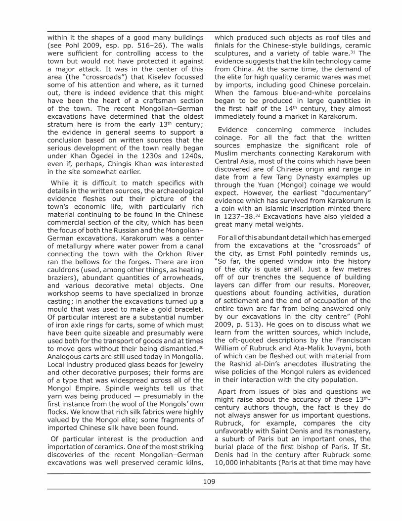
numbered some 200,000), what does this tell us about Karakorum’s population? We might assume that it rose and ebbed with the seasons and to some extent depended on whether the Mongol court was actually in residence. Indeed, so far, the excavations have yielded practically nothing we might associate fi rmly with Karakorum’s Mongol population, which likely lived in gers (trellis tents) [Fig. 7].
Rubruck’s description of buildings in the Mongol capital leaves us with many puzzles, since most, if not all of them, have yet to be documented archaeologically. He writes about “large palaces belonging to the court secretaries,” “twelve idol [i.e., Buddhist] temples,” “two mosques” and “one Christian church.” Perhaps best known of Rubruck’s observations is what he tells us about the khan’s palace, with its wondrous fountain in the courtyard built for the Khan by the captive Parisian goldsmith Guillaume Boucher (ibid., pp. 209–11). An imaginative 18th–century European image of this palace, which originally illustrated a published version of Rubruck’s account (Dschingis 2005, p. 154), graces some of today’s Mongol currency.
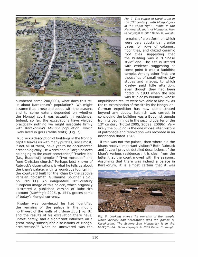
Kiselev was convinced he had identifi ed the remains of the palace in the mound northwest of the walls of Erdene Zuu [Fig. 8], and the results of his excavation there have, unfortunately, had a signifi cant infl uence on a great many subsequent discussions of Mongol architecture.33 What he uncovered was the
remains of a platform on which were very substantial granite bases for rows of columns, fl oor tiles, and glazed ceramic roof tiles suggesting that the building was a “Chinese style” one. The site is littered with evidence suggesting at some point it was a Buddhist temple. Among other fi nds are thousands of small votive clay stupas and images, to which Kiselev paid little attention, even though they had been noted in 1933 when the site was studied by Bukinich, whose
unpublished results were available to Kiselev. As the re-examination of the site by the Mongolian-German expedition has now demonstrated beyond any doubt, Bukinich was correct in concluding the building was a Buddhist temple from its beginnings in the second quarter of the 13th century (Hüttel 2005, 2009a, 2009b). Very likely the building is the one whose later history of patronage and renovation was recorded in an inscription dated 1346.
If this was not the palace, then where did the khans receive important visitors? Both Rubruck and Juvayni provide detailed descriptions of the khan’s various residences; it is clear from the latter that the court moved with the seasons. Assuming that there was indeed a palace in Karakorum, it is almost certain that it was
Fig. 7. The center of Karakorum in the 13th century, with Mongol gers in the upper right. Model in the National Museum of Mongolia. Pho-to copyright © 2007 Daniel C. Waugh.
Fig. 8. Looking across the remains of the temple which Kiselev had determined was the palace at Karakorum. The Erdene Zuu Monastery is in the background. Photo copyright © 2005 Daniel C. Waugh.
110
located on the site now occupied by the Erdene Zuu monastery, where the recent excavations have begun to uncover very substantial masonry foundations of an important structure. There is as yet though no archaeological evidence to correlate with Rubruck’s description of the wondrous fountain in the palace courtyard. Even if we may never identify for certain that building, there is considerable evidence about what seem to have been royal residences in what Moses and Greer (1998) have termed the “peri-urban environment” of Karakorum.34 That is, we can document from written sources and are now in a position to confi rm this from archaeological evidence (if correlating the two is still somewhat problematic) that there was a network of elite sites, with substantial buildings, which constituted the seasonal orbit of the khan when he was not off on more distant campaigns. This pattern of seasonal movement is similar to what we are fairly certain was observed by the earlier nomadic courts in the Xiongnu and Uighur periods.
For all the fact that substantial Chinese-style buildings may have been common enough in Karakorum, our knowledge of its architecture is still surprisingly limited. Apart from the “palace” site, the detailed excavations have focussed on what most agree was the Chinese quarter in the town. While a Muslim cemetery has been excavated, we still have no evidence of the mosque or mosques which the city is supposed to have contained or the residences the arguably substantial Muslim merchant population may have occupied.35 The model of Karakorum now in the National Museum of Mongolia depicts, inter alia, a caravan-sarai, but there is no physical evidence concerning such a structure. Nor has anything been discovered of the Eastern Christian church reported by Rubruck. Most scholars would agree that the relatively small permanent core of the city was surrounded by a large area where the Mongols would pitch their tents or gers, a pattern which persists even today, where ger suburbs are part of the urban landscape even in the Mongol capital Ulaanbaatar. Understandably, as yet we have no concrete evidence to document such structures, given their temporary nature and the fl ooding which occurred over the centuries.
Juvayni’s description of a palace complex north of Karakorum in the Orkhon valley, one built by Muslim architects, may well be accurate, although it is not entirely clear whether we
should accept Shiraishi’s identifi cation of the site with the archaeologically documented one of Doityn Balgas. While the construction and decoration of the main building seems not to be “Chinese,” its layout and dimensions resemble those of the Buddhist temple in Karakorum formerly considered to have been the khan’s palace. There is still much to be done in studying Doityn Balgas and the other outlying “palace” sites surrounding Karakorum.
We might conclude this overview of Mongol Empire settlements in Mongolia with a brief review of the evidence concerning Kondui, one of the most impressive “urban” sites, assumed to have been built by the Mongol elite, probably members of the Chingisid clan.36 It is located to the north of Khirkhira in Transbaikalia (southeast of the city of Chita). While there are several buildings, the one which underestandably has attracted the most attention is the large cruciform “palace,” which embodies many features of Chinese architecture. The lower terrace of this impressive structure extends some 250 m. There are abundant remains of the tiled roof (whose yellow and red glaze suggests that the structure was for a member of the royal family), a lacquered railing, dozens of carved stone dragon heads which decorated the perimeter of the terrace, and much more. The Russian excavations also studied what Kiselev terms a pavilion near the palace and the remains of an entrance gate. The date of Kondui is uncertain, though Kiselev asserts (for reasons that are not entirely clear) that it must post-date the “palace” at Karakorum. He also suggests that Kondui was destroyed in the period of unrest following the collapse of the Yuan Dynasty in the late 14th century which also witnessed the destruction of Karakorum by a Ming army in 1388.
A good many major sites in China or Inner Mongolia date from the period after Khubilai Khan moved his capital to the present-day location of Beijing in the 1260s and began to conquer the rest of the country (see Steinhardt 1988). We are talking here of very large walled areas whose layout refl ects the by then standard model of Chinese Imperial city planning, usually with a palace and temple complex centered in the northern sector and facing south along the main axis of the city. For my purposes here, perhaps the most interesting of these sites is Shangdu, built as the summer palace for Khubilai way out in the sparsely populated
111
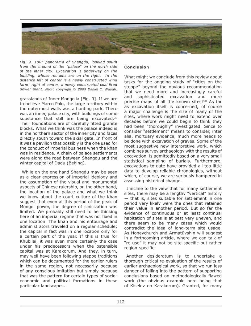
grasslands of Inner Mongolia [Fig. 9]. If we are to believe Marco Polo, the large territory within the outermost walls was a hunting park. There was an inner, palace city, with buildings of some substance that still are being excavated.37 Their foundations are of carefully fi tted granite blocks. What we think was the palace indeed is in the northern sector of the inner city and faces directly south toward the axial gate. In front of it was a pavilion that possibly is the one used for the conduct of imperial business when the khan was in residence. A chain of palace settlements were along the road between Shangdu and the winter capital of Dadu (Beijing).
While on the one hand Shangdu may be seen as a clear expression of imperial ideology and the assumption of the visual and monumental aspects of Chinese rulership, on the other hand, the location of the palace and what we think we know about the court culture of the Khan suggest that even at this period of the peak of Mongol power, the degree of sinicization was limited. We probably still need to be thinking here of an imperial regime that was not fi xed in one location. The khan and his entourage and administrators traveled on a regular schedule; the capital in fact was in one location only for a certain part of the year. If this is true for Khubilai, it was even more certainly the case under his predecessors when the ostensible capital was at Karakorum. And they, in turn, may well have been following steppe traditions which can be documented for the earlier rulers in the same region, not necessarily because of any conscious imitation but simply because that was the pattern for certain types of socio-economic and political formations in these particular landscapes.
Conclusion
What might we conclude from this review about tasks for the ongoing study of “cities on the steppe” beyond the obvious recommendation that we need more and increasingly careful and sophisticated excavation and more precise maps of all the known sites?38 As far as excavation itself is concerned, of course a major challenge is the size of many of the sites, where work might need to extend over decades before we could begin to think they had been “thoroughly” investigated. Since to consider “settlement” means to consider, inter alia, mortuary evidence, much more needs to be done with excavation of graves. Some of the most suggestive new interpretive work, which combines survey archaeology with the results of excavation, is admittedly based on a very small statistical sampling of burials. Furthermore, excavations to date have provided all too little data to develop reliable chronologies, without which, of course, we are seriously hampered in assessing historical change.
I incline to the view that for many settlement sites, there may be a lengthy “vertical” history — that is, sites suitable for settlement in one period very likely were the ones that retained their value in another period. But so far the evidence of continuous or at least continual habitation of sites is at best very uneven, and there seem to be many cases which would contradict the idea of long-term site usage. As Honeychurch and Armatüvshin will suggest in a forthcoming article, where we can talk of “re-use” it may not be site-specifi c but rather region-specifi c.
Another desideratum is to undertake a thorough critical re-evaluation of the results of earlier archaeological work, so that we run less danger of falling into the pattern of supporting conclusions based on methodologically fl awed work (the obvious example here being that of Kiselev on Karakorum). Granted, for many
Fig. 9. 180° panorama of Shangdu, looking south from the mound of the “palace” on the north side of the inner city. Excavation is underway on the building, whose remains are on the right. In the distance left of center is a newly constructed wind farm; right of center, a newly constructed coal fi red power plant. Photo copyright © 2009 Daniel C. Waugh.
112
fi elds it is true that what at one time may have been a major contribution casts far too long a shadow because of its perceived authority, even if a fi eld methodologically has made substantial advances since that work was done.
Part of this reassessment of the impact of earlier work has to involve re-thinking how we may best determine the possible relationship between material of one period or region and another — that is, among other things, concepts of what constitutes “infl uence” and “borrowing” need to be re-examined. Assertions have been made about Central Asian, East Asian or Chinese infl uences in Mongolia; furthermore, efforts have been made to delineate what might be considered distinctive Mongolian features of, say, architecture. But too much of the literature bases such views (at least tacitly) on outdated concepts of “ethnicity” or “identity” and may refl ect the long-ingrained biases of the “sedentary civilizations” about the “nomads.” We fi nd plenty of evidence about cultural and economic interactions, where the archaeology reinforces what the written sources sometimes relate through their biased lenses. Yet much of the newer archaeological work in various parts of the world emphasizes how we need to be very cautious about interpreting the signifi cance of fi nding similar objects of material culture in what are otherwise presumed to be culturally or ethnically distinct areas (see, e.g., Curta 2001).
Moreover, we need to keep in mind that within any larger cultural sphere, there can be a considerable degree of regional variation. While on the one hand we would be well served to see a better integration and comparison of specifi c site analysis from, say, Inner Mongolia, with that of, say, Buriatia, on the other hand we need to be sensitive to the fact that even if sites in areas as far removed as those are ones that may be attributed to the same polity or ethnic grouping, they may have quite distinct features. Learning about “peripheries” and not just important locations at “the center” is
important here (see Miller et al. 2009a, 2009b).
We need to think carefully about where the concentrations of settlements are for different periods. I am struck, for example, by what seems to be a concentration of important Xiongnu sites relatively far to the north and by the fact that some of the most dramatic evidence of Mongol Empire settlements is from southern Siberia. Of course this impression may simply refl ect which areas have received to date the most extensive investigation, not the actual focal points of human activity in earlier periods. In this connection, among the most promising of the new ideas regarding Mongolia’s early history and its archaeology are those which are attempting to relate particular archaeological assemblages to surrounding and even more distant landscapes and to develop analytical methods that may permit diachronic comparisons over possibly extended periods. It seems as though one can in fact provide convincing hypotheses regarding changes in resource exploitation and the possible relationship of those not only to changes in climate but to evolution of political and social forms.
It should not surprise us that the evidence about settlements in Mongolia shows considerable change over time. Not only did they change substantially in size (which is not to say that there was a steady progression from small seasonal camps to genuine cities), but there were also were many variants in their functions and the length of time for which they were occupied. So far we have stimulating, if yet tentative explanations of some of these changes. We know too little though about whether certain resources were exploited by those living in close proximity or perhaps only from more distant locations. And insofar as nomadic polities and their leaders moved around, we likewise know too little about the different locations of, say, summer and winter camps, and how settlements of some consequence may have been linked to some
113
kind of “central authority.” In all this, of course, we must anticipate that analytical models with may work well for one period may not be applicable to another one, even if at their base are quite generalized theories of social interaction.
While the terminologies employed in some of the most interesting recent interpretive studies of the archaeological material from “greater Mongolia” may be different, I think the concept of “non-uniform complexity” recently enunciated by Michael Frachetti (2009) provides a promising analytical approach. His re-assessment of the evidence from various studies of the western Eurasian Bronze Age steppe cultures fi nds that older “progressive models of social and political evolution” simply are inadequate to explain the archaeolgical data. Those same “progressive models” have been used in much of the older literature on settlements in Mongolia. Given the diversity of settlement in Mongolia and the unevenness of its development over time and space, we might well agree with Frachetti that “complexity among steppe communities is better evaluated in terms of institutional integration or fragmentation at the interstices of diverse populations whose economic and political interests co-exist geographically but are not necessarily bound by a shared sense of society.” Moreover, there is an important issue of scale of human institutional development, where we must be looking at “regional ecological settings” which may then explain the distinctiveness of many of the archaeological assemblages. Whether Frachetti’s ideas can be applied to periods and societies more recent than those of the Bronze Age (that is, when we can document, for example, a strikingly different confi guration of political institutions encompassing much larger territories) remains to be tested. Maybe, in fact, “settlements” and “cities” should not be discussed in the same breath as I have tried to do here.
Learning more about the complexities of pre-modern societies in “greater Mongolia” can contribute signifi cantly to reassessments of developments in other parts of Eurasia. After all, this region, remote as it may seem from a modern perspective, was hardly a “periphery” historically. Not the least of the results of such research may be to lay to rest once and for all the stereotypes about “nomads” which have too long dominated the thinking about Inner Asia.39
Acknowledgements
I am deeply indebted to Prof. Jan Bemmann and Dr. Ursula Brosseder of the University of Bonn, Prof. Johan Elverskog of Southern Methodist University, and especially Prof. William Honeychurch of Yale University, all of whom read a draft of this article and provided me with valuable suggestions and materials for its improvement. Naturally they bear no responsibility for its shortcomings. Prof. Bemmann kindly provided me with pre-publication copies of a number of the essays cited here from the forthcoming large volume of the excavation reports of the Mongolian–German Karakorum expedition.
About the author
Daniel Waugh, a retired historian at the University of Washington and editor of The Silk Road, participated in archaeological excavation of Xiongnu sites in Mongolia in 2005 and 2007. He translated the important monograph by Prokopii B. Konovalov on his excavation of a Xiongnu terrace tomb in Transbaikalia, published as Vol. 3 in the Bonn Contributions to Asian Archaeology.
References
Allard et al. 2002 (2006)
Francis Allard, Diimaajav Erdenebaatar and Jean-Luc Houle. “Recent Archaeological Research in the Khanuy River Valley, Central Mongolia.” In: Beyond 2006: 202–224.
Allard and Erdenebaatar 2005
Francis Allard and Diimaajav Erdenebaatar. “Khirigsuurs, ritual and mobility in the Bronze Age of Mongolia.” Antiquity 79 (2005): 1–18.
Allsen 1996
Thomas T. Allsen. “Spiritual Geography and Political Legitimacy in the Eastern Steppe.” In: Ideology and the Formation of Early States, ed. Henri J. M. Claessen and Jarich G. Oosten. Leiden: Brill, 1996, pp. 116-135.
Archaeology 2008
The Archaeology of Mobility: Old World and New World Nomadism. Ed. Hans Barnard and Willeke Wendrich. Cotsen Advanced Seminars 4. Cotsen Institute of Archaeology, Los Angeles: University of California, 2008.
114
Artem’ev 2001
A. R. Artem’ev. “Novye issledovaniia goroda mongol’skogo khana Esungu v Zabaikal’e (XIII–XIV vv.)” [New studies of the city of the Mongolian Khan Esunge in Transbaikalia (13th-14th centuries)]. In: Drevniaia 2001: 253–265.
Artem’ev 2004
A. R. Artem’ev. “Arkheologicheskie pamiatniki epokh Iuan’ i Min’ v Zabaikal’e i Priamur’e (XIII–XV vv.)” [Archaeological monuments of the Yuan and Ming eras in Transbaikalia and Priamuria (13th-14th centuries)]. Rossiiskaia arkheologiia 2004/4: 83–94.
Baasan 2006
Tudeviin Baasan. Chingisiin Dalan gezh iuu ve?/What is the Chinggis Wall?. Ulaanbaatar: “Admon,” 2006. (in Mongolian and English).
Becker 2007
Eva Becker. Die altmongolische Hauptstadt Kara-korum: Forschungsgeschichte nach historischen Aussagen und archäologischen Quellen. Inter-nationale Archäologie, 39. Rahden/Westf.: Leidorf, 2007.
Beckwith 2009
Christopher Beckwith. Empires of the Silk Road: A History of Central Eurasia from the Bronze Age to the Present. Princeton and Oxford: Princeton Univ. Pr. 2009.
Bemmann and Munkhbayar 2010
Jan Bemmann and Lkhagvadorj Munkhbayar. “Im Zentrum der Steppenreiche.” Archäologie in Deutschland 2010/3: 14-18.
Bemmann et al. 2010
Jan Bemmann, Henny Piezonka, Birte Ahrens. “Geoarchäologie in der Steppe – Zur Rekonstruktion von Kulturlandschaften im Orchon-Tal, Zentrale Mongolei.” <http://www.vfgarch.uni-bonn.de/forschung-1/aktuelle-projekte/geoarchaeologie-in-der-steppe>, accessed June 5, 2010.
Beyond 2006
Beyond the Steppe and the Sown: Proceedings of the 2002 University of Chicago Conference on Eurasian Archaeology, ed. DL Peterson et al. Leiden; Boston: Brill, 2006
Biran 2005
Michal Biran. The Empire of the Qara Khitai in Eurasian History: Between China and the Islamic World. Cambridge etc.: Cambridge University Press, 2005.
Brosseder 2009
Ursula Brosseder. “Xiongnu Terrace Tombs and Their Interpretation as Elite Burials.” In: Current Research 2009: 246-280.
Choido 2005
Elisabetta Chiodo. “Die mongolischen Manuskripte auf Birkenrinde aus Charbuchyn Balgas.” In: Dschingis 2005: 112–113.
Current Research 2009
Current Archaeological Research in Mongolia: Papers from the First International Conference on “Archaeological Research in Mongolia” held in Ulaanbaatar, August 19th-23rd, 2007, ed. Jan Bemmann et al. Bonn: Vor- und Frühgeschichtliche Archäologie, Rheinische Friedrich-Wilhelms-Universi-tät, 2009.
Curta 2001
Florin Curta. The Making of the Slavs: History and Archaeology of the Lower Danube Region c. 500–700. Cambridge, etc.: Cambridge University Press, 2001.
Danilov 2002
Sergei V. Danilov. “Temnikovskoe poselenie i nekotorye voprosy etnogeneza Buriat” [A temnik’s settlement and some questions of the ethnogenesis of the Buriats]. In: Mir Tsentral’noi Azii: Arkheologiia, etnologiia, Vol. 1,. Ulan-Ude: Izd-vo. BNTs SO RAN, 2002: 21–25.
Danilov 2004
Sergei V. Danilov. Goroda v kochevykh obshchestvakh Tsentral’noi Azii [Cities in nomadic societies of Inner Asia]. Ulan-Ude: Izd-vo. Buriatskogo nauchnogo tsentra SO RAN, 2004.
Dashibalov 2005
Bair B. Dashibalov. Na mongolo-tiurkskom pogranich’e (Etnokul’turnye protsessy v Iugo-Vostochnoi Sibiri v srednie veka) [On the Mongolian-Turkic borderlands (Ethno-cultural processes in southeastern Siberia in the Middle Ages]. Ulan-Ude: Izd-vo. BNTs SO RAN, 2005.
Davydova 1988
A. V. Davydova. “The Ivolga Gorodishche (A Monu-ment of the Hsiung-nu Culture in the Trans-Baikal Region).” Acta Archaeologica Academiae Scientiarum Hungaricae 20 (1988): 209–245.
Davydova 1995
A. V. Davydova. Ivolginskii arkheologicheskii kompleks. T. 1. Ivolginskoe gorodishche/The Ivolga Archaeological Complex. Vol. 1: The Ivolga Fortress. Arkheologicheskie pamiatniki siunnu, Vyp. 1. St. Petersburg: Peterburgskoe vostokovedenie, 1995.
Davydova 1996
A. V. Davydova. Ivolginskii arkheologicheskii kompleks. T. 2. Ivolginskii mogil’nik/The Ivolga Archaeological Complex. Vol. 2. The Ivolga Cemetery. Arkheologicheskie pamiatniki siunnu, Vyp. 2. St. Petersburg: Fond “AziatIKA,” 1996.
115
Davydova and Miniaev 2003
A. V. Davydova and Sergei S. Miniaev 2003, Kompleks arkheologicheskikh pamiatnikov u sela Dureny [The complex of archaeological monuments at the village of Dureny]. Arkheologicheskie pamiatniki siunnu, Vyp. 5. St. Petersburg: Fond “AziatIKA,” 2003.
Dien 2007
Albert E. Dien. Six Dynasties Civilization. New Haven; London: Yale University Press, 2007.
Drevniaia 2001
Drevniaia i srednevekovaia istoriia Vostochnoi Azii. K 1300–letiiu obrazovaniia gosudarstva Bokhai [Ancient and medieval history of Eastern Asia. On the 1300th anniversary of the founding of the Bohai state]. Vladivostok: Institut istorii, arkheologii i etnografi i narodov Dal’nego Vostoka DVO RAN, 2001.
Drompp 1999
Michael R.Drompp. “Breaking the Orkhon Tradition. Kirghiz Adherence to the Yenisei Region after A.D. 840.” Journal of the American Oriental Society 119/3 (1999): 390–403.
Dschingis 2005
Dschingis Khan und seine Erben: Das Weltreich der Mongolen. München: Hirmer Verlag, 2005.
Erdenebat and Pohl 2009
Ulambayar Erdenebat and Ernst Pohl. “The Crossroads in Khara Khorum: Excavations at the Center of the Mongol Empire.” In Genghis 2009: 137–149.
Fitzhugh 2009
William W. Fitzhugh. “Pre-Scythian Ceremonialism, Deer Stone Art, and Cultural Intensifi cation in Northern Mongolia.” In: Social Complexity 2009: 378-411.
Frachetti 2008
Michael D. Frachetti. Pastoral Landscapes and Social Interaction in Bronze Age Eurasia. Berkeley etc.: Univ. of California Pr., 2008.
Frachetti 2009
Michael D. Frachetti. “Differentiated Landscapes and Non-uniform Complexity among Bronze Age Societies of the Eurasian Steppe.” In: Social Complexity 2009: 19–46.
Franken 2005
Christina Franken. “Die Brennöfen im Palastbezirk von Karakorum.” In Dschingis 2005: 147–149.
Frohlich et al. 2004
Bruno Frohlich et al. “The Khirigsuur Tombs in the Hovsgol aimag, Northern Mongolia: Mapping, and Analysis.” In: The Hovsgol Deer Stone Project 2003 Field Report, ed. William Fitzhugh.Washington, D. C.: Smithsonian Institution; Ulaanbaatar: National Museum of Mongolian History, 2004: 42–61.
Frohlich et al. 2005
Bruno Frohlich et al. “Burial Mounds in Hovsgol Aimag, Northern Mongolia: Preliminary Results from 2003 and 2004.” In: The Deer Stone Project: Anthropological Studies in Mongolia 2002–2004, ed. William Fitzhugh.Washington, D. C.: Smithsonian Institution; Ulaanbaatar: National Museum of Mongolian History, 2005: 57–88.
Frohlich et al. 2009
Bruno Frohlich et al. “Bronze Age Burial Mounds in the Khövsgöl aimag, Mongolia.” In: Current Research 2009: 99–115.
Gabain 1950
Annemarie von Gabain. “Steppe und Stadt im Leben der ältesten Türken.” Der Islam 29 (1950): 30–62.
Genghis 2009
Genghis Khan and the Mongol Empire, ed. William W. Fitzhugh, Morris Rossabi, and William Honeychurch. Santa Barbara, CA : Perpetua Press, 2009.
Gilded 2006
Gilded Splendor: Treasures of China’s Liao Empire (907–1125), ed. Hsueh-man Shen, New York: Asia Society, 2006.
Han 2001
Han Giu-cheol. “Kidani i chzhurchzheni kak ostavshiesia Bokhaitsy / Qidan and Jurchen as Palhai Remainders” [in Russian and English]. In: Drevniaia 2001: 66–71.
Heidemann 2005
Stefan Heidemann. “Münzen — Dokumente zur Politik, Wirtschaft und Kultur des Mongolenreichs.” In Dschingis 2005: 203–08.
Heidemann et al. 2006
Stefan Heidemann et al. “The First Documentary Evidence for Qara Qorum from the year 635/1237–38.” Zeitschrift für Archäologie Aussereuropäischer Kulturen 1 (2006): 93–102.
Honeychurch and Amartüvshin (2002) 2006
William Honeychurch and Chunag Amartüvshin. “Survey and Settlement in Northern Mongolia: The Structure of Intra-Regional Nomadic Organization.” In: Beyond 2006: 183–201.
Honeychurch and Amartüvshin 2006
William Honeychurch and Chunag Amartüvshin. “States on Horseback: The Rise of Inner Asian Confederations and Empires.” In: Archaeology of Asia, ed. Miriam Stark. Malden, MA: Blackwell, 2006: 255-278.
Honeychurch and Amartüvshin 2007
William Honeychurch and Chunag Amartüvshin. “Hinterlands, Urban Centers, and Mobile Settings:
116
The ‘New’ Old World Archaeology from the Eurasian Steppe.” Asian Perspectives 46/1 (2007): 36–64.
Honeychurch and Amartüvshin forthcoming
William Honeychurch and Chunag Amartüvshin. “Timescapes from the Past: An Archaeogeography of Mongolia.” In: Mapping Mongolia, ed. Paula Sabloff and Fredrik Hiebert. Philadelphia: Univ. of Pennsylvania Press.
Honeychurch et al. 2009
William Honeychurch, Joshua Wright, and Chunag Amartüvshin. “Re-writing Monumental Landscapes as Inner Asian Political Process.” In: Social Complexity 2009: 330–57.
Houle 2009
Jean-Luc Houle. “Socially Integrative Facilities and the Emergence of Societal Complexity on the Mongolian Steppe.” In: Social Complexity 2009: 358–77.
Houle and Erdenebaatar 2009
Jean-Luc Houle and Diimaazhav Erdenebaatar. “Investigating Mobility, Territoriality and Complexity in the Late Bronze Age: An Initial Perspective from Monuments and Settlements.” In: Current Research 2009: 117–34.
Hüttel 2005
Hans-Georg Hüttel. “Der Palast des Ögedei Khan — Die Ausgrabungen des Deutsches Archäologischen Instituts im Palastbezirk von Karakorum.” In: Dschingis 2005: 140–46.
Hüttel 2009a
Hans-Georg Hüttel. “The Search for Khara Khorum and the Palace of the Great Khan.” In: Genghis 2009: 146–49.
Hüttel 2009b
Hans-Georg Hüttel. “Royal Palace or Buddhist Temple? On Search for the Karakorum Palace.” In: Current Research 2009: 535–48.
Hyer 1982
Paul Hyer. “An Historical Sketch of Köke-Khota City Capital of Inner Mongolia.” Central Asiatic Journal 26/1–2 (1982): 56–77.
Jacobson et al. 2001
Esther Jacobson, Vladimir Kubarev and Damden-surenjin Tseveendorj. Répertoire des Pétroglyphes d’Asie Centrale. Fasc. No. 6: Mongolie du nord-ouest Tsagaan Salaa/Baga Oigor, 2 v. Paris: De Boccard, 2001.
Jacobson et al. 2005
Esther Jacobson [Iakobson], Vladimir D. Kubarev and Damdinsüren Tseveendorzh. Petroglify Tsagaan-Salaa i Baga-Oigura (Mongol’skii Altai). Novosibirsk etc.: Izd-vo. Instituta arkheologii i etnografi i SO RAN, 2005.
Jacobson-Tepfer 2008
Esther Jacobson-Tepfer. “The Emergence of Cultures of Mobility in the Altai Mountains of Mongolia: Evidence from the Intersection of Rock Art and Paleoenvironment.” In: Archaeology 2008: 200–229.
Jacobson-Tepfer et al. 2006
Esther Jacobson-Tepfer, Vladimir Kubarev and Damdensurenjin Tseveendorj. Répertoire des Pétroglyphes d’Asie Centrale. Fasc. No. 7: Mongolie du nord-ouest Haut Tsagaan Gol, 2 v. Paris: De Boccard, 2006.
Jacobson-Tepfer et al. 2010
Esther Jacobson-Tepfer, James E. Meacham and Gary Tepfer. Archaeology and Landscape in the Mongolian Altai: An Atlas. Redlands, California: ESRI Press, 2010.
Jagchid 1981
Sechin Jagchid. “The Kitans and Their Cities.” Central Asiatic Journal 25/1-2 (1981): 70–88.
Juvayni 1958
Ata-Malik Juvayni. The History of the World Conqueror, tr. John Andrew Boyle, 2 v. Manchester: Manchester University Press, 1958.
Kessler et al. 1994
Adam T. Kessler et al. Empires Beyond the Great Wall: The Heritage of Genghis Khan. Los Angeles: Natural History Museum of Los Angeles County, 1994.
Khudiakov and Tseveendorzh 1982
Iurii S. Khudiakov and Damdinsüren Tseveendorzh. “Keramika Ordu-Balyka” [Ceramics of Ordu-Balyk]. In: Arkheologiia Severnoi Azii. Novosibirsk: Izd-vo. “Nauka,” Sibirskoe otd., 1982: 85–94.
Kirillov et al. 2001
I. I. Kirillov, E. V. Kovychev and A. Iu. Litvintsev. “Sian’biiskie graffi ti na bereste iz mogil’nika Zorgol-1” [Xianbei graffi ti on birchbark from the Zorgol-1 cemetery]. In: Drevniaia 2001: 266-272.
Kiselev 1957
Sergei V. Kiselev. “Drevnie goroda Mongolii” [Ancient cities of Mongolia]. Sovetskaia arkheologiia 1957/2: 97–101.
Kiselev 1958
Sergei V. Kiselev. “Drevnie goroda Zabaikal’ia” [Ancient cities of Transbaikalia]. Sovetskaia arkheologiia 1958/4: 107–19.
Kiselev 1965
Sergei V. Kiselev. “Konduiskii gorodok” [The town of Kondui]. In Kiselev et al. 1965: 325–368.
Kiselev et al. 1965
Sergei V. Kiselev et al. Drevnemongol’skie goroda
117
[Ancient Mongolian cities]. Moscow: Izd-vo. “Nauka, ” 1965.
Kolbas 2005
Judith G. Kolbas. “Khukh Ordung: A Uighur Palace Complex of the Seventh Century.” Journal of the Royal Asiatic Society, Ser. 3, 15/3 (2005): 303–327.
Kradin 2001
Nikolai N. Kradin. Imperiia Khunnu [The Xiongnu Empire], 2nd ed. Moscow: “Logos,” 2001.
Kradin et al. 2005
Nikolai N. Kradin. “Preliminary Results of the Investigation of Kitan Ancient Town Chintolgoi Balgas in 2004.” Nomadic Studies Bulletin (International Institute for the Study of Nomadic Civilizations) 10 (2005): 72–80.
Kradin 2008
Nikolai N. Kradin. “Urbanizatsionnye protsessy v kochevykh imperiiakh mongol’skoi stepi” [Urbanization processes in the nomadic empires of the Mongolian steppe]. In Mongol’skaia imperiia i kochevoi mir, bk. 3, ed. B. V. Bazarov et al. Ulan-Ude: Izd-vo. BNTs SO RAN, 2008: 330-346.
Kyzlasov 1959
Leonid R. Kyzlasov. “Srednevekovye goroda Tuvy” [Medieval cities of Tuva]. Sovetskaia arkheologiia 1959/3: 66–75.
Kyzlasov 1965
Leonid R. Kyzlasov. “Gorodishche Dën-Terek” [The settlement site of Dën-Terek]. In Kiselev et. al. 1965: 59–119.
Lee 2009
Christine Lee. “Who were the Mongols (1100-1400 CE)? An Examination of Their Population History.” In: Current Research 2009: 579–91.
Lun’kov et al. 2009
A. V. Lun’kov et al. “Pogranichnye sooruzheniia kidanei v Zabaikal’e” [Border constructions of the Khitans in Transbaikalia]. Izvestiia Laboratorii drevnikh tekhnologii [Irkutskogo gos. tekhnicheskogo un-ta.], vyp. 7 (2009): 155–72.
Maidar 1971
D. Maidar. Arkhitektura i gradostroitel’stvo Mongolii. Ocherki po istorii [Architecture and city construction in Mongolia: Essays on their history]. Moscow: Stroiizdat, 1971.
Miller et al. 2009a
Bryan K. Miller et al. “Xiongnu Constituents of the High Mountains: Results of the Mongol-American Khovd Archaeology Project, 2008.” The Silk Road 7 (2009): 8–20.
Miller et al. 2009b
Bryan K. Miller et al. “Elite Xiongnu Burials at the Periphery: Tomb Complexes at Takhiltyn Khotgor, Mongolian Altai.” In: Current Research 2009: 301–14.
Minert 1985
L. K. Minert. “Drevneishie pamiatniki mongol’skogo monumental’nogo zodchestva” [The oldest monuments of Mongolian monumental architecture]. In: Drevnie kul’tury Mongolii. Novosibirsk: “Nauka,” 1985: 184–209.
Miniaev 2001
Sergei S. Miniaev. “Siunnuskii kul’turnyi kompleks: vremia i prostranstvo” [The Xiongnu cultural complex: its time and extent]. In: Drevniaia 2001: 295–304.
Miniaev and Elikhina 2009
Sergei S. Miniaev and Julia I. Elikhina. “On the Chronology of the Noyon uul Barrows.” The Silk Road 7 (2009): 21–35.
Miniaev and Sakharovskaia 2007
Sergei S. Miniaev and Lidiia M. Sakharovskaia. “Investigation of a Xiongnu Royal Complex in the Tsaraam Valley. Part 2: The Inventory of Barrow No. 7 and the Chronology of the Site.” The Silk Road 5/1 (2007): 44–56.
Minorsky 1948
Vladimir Minorsky. “Tamim ibn Bahr’s Journey to the Uighurs.” Bulletin of the School of Oriental and African Studies, University of London 12/2 (1948): 275–305.
Mongol nutag 1999
Mongol nutag dakh’ tuukh soelyn dursgal [His-torical and Cultural Monuments of Mongolia], ed. Damdinsüren Tseveendorj et al. Ulaanbaatar: Mongolyn Khutuunlegiin ukhaany akademi, 1999.
Mongolian–German forthcoming
Mongolian–German Karakorum Expedition. Vol. 1. Excavations in the Craftsman Quarter at the Main Road, ed. Jan Bemmann, Ulambayar Erdenebat and Ernst Pohl. Forschüngen zur Archäologie Aussereuropäischer Kulturen, 8. Wiesbaden: Reichert Verlag.
Moriyasu and Ochir 1999
Moriyasu Takao and Ayudai Ochir. Provisional Report of Researches on Historical Sites and Inscriptions in Mongolia from 1996 to 1998. Osaka: Society of Central Eurasian Studies, 1999.
Moses and Greer 1998
Larry Moses and Charles Greer. “Kara Korum and its Peri-Urban Environment: The Imperial District of the Mongol Empire.” Eurasian Studies Yearbook 70 (1998): 105–22.
118
Nagrodzka-Majchrzyk 1978
Teresa Nagrodzka-Majchrzyk. Geneza miast u davnych ludów tureckich (VII–XII w.) [The origin of cities among the ancient Turkic peoples (7th–12th centuries)]. Wrocław etc.: Zakład narodowy im. Ossolińskich; Wyd. Polskiej Akademii nauk, 1978.
Nelson et al. 2009
Albert Russell Nelson, Chunag Amartüvshin and William Honeychurch. “A Gobi Mortuary Site Through Time: Bioarchaeology at Baga Mongol, Gaga Gazaryn Chuluu.” In: Current Research 2009: 565–78.
Obrusanszky 2009
Borbala Obrusanszky. “Tongwancheng, the city of Southern Huns.” Transoxiana 14 (August 2009), online at <http://www.transoxiana.org/14/ obrusanszky_tongwan_city.html>.
Ochir and Erdenebold 2009
Ayudai Ochir and Lkhagvasüren Erdenebold. “About the Uighur City of Khedun, Mongolia.” In: Current Research 2009: 437–42.
Ochir et al. 2010
Ayudai Ochir et al. “Ancient Uighur Mausolea Discovered in Mongolia.” The Silk Road 8 (2010): XX–YY.
Oczipka et al. 2009
M. Oczipka et al. “Small Drones for Geo-Archaeology in the Steppe: Locating and Documenting the Archaeological Heritage of the Orkhon Valley in Mongolia.” In: Remote Sensing for Environmental Monitoring, GIS Applications, and Geology IX. Ed. U. Michel and D. L. Civco. Proceedings of SPIE, Vol. 7478 (Bellingham, WA: SPIE, 2009), 7478-06.
Perlee 1957
Kh. [Khuduugiin] Perlee. “K istorii drevnikh gorodov i poselenii v Mongolii” [On the history of ancient cities and settlements in Mongolia]. Sovetskaia arkheologiia 1957/3: 43–53.
Perlee 1961
Kh. Perlee. Mongol ard ulsyn ert, dundad ueiin khot suuriny tovchoon [A short history of ancient and medieval cities and settlements on the territory of the Mongolian People’s Republic]. Ulaanbaatar: Ulsyn khevleliin khereg erkhlekh khoroo, 1961.
Perlee 1962
Kh. Perlee. “Kidan’skie goroda i poseleniia na territorii Mongol’skoi Narodnoi Respubliki (X–nachalo XII v.)” [Khitan cities and settlements on the territory of the Mongolian People’s Republic (10th–12th centuries)]. In: Mongol’skii arkheologicheskii sbornik. Moscow: Izd-vo. Akademii nauk SSSR, 1962: 55–62.
Permanent Mission 2003
The Permanent Archaeological Joint Mongolian
and Japanese Mission 2003, Preliminary Report on Archaeological Investigations in Mongolia 2003, Newsletter on Steppe Archaeology, No. 14; online: <http://web.kanazawa-u.ac.jp/~steppe/ news14.html>.
Permanent Mission 2004
The Permanent Archaeological Joint Mongolian and Japanese Mission 2004, Preliminary report of the Archaeological Investigations in Mongolia 2004. Newsletter on Steppe Archaeology, No. 15; online: <http://web.kanazawa-u.ac.jp/~steppe/ news15.html>.
Pohl 2009
Ernst Pohl. “Interpretation without Excavation — Topographic Mapping on the Territory of the First Mongolian Capital Karakorum.” In: Current Research 2007: 505-33.
Por-Bazhin [2007]
Proekt “Krepost’ Por-Bazhin”. Nauchnyi al’manakh. N.p., ca. 2007.
Pousaz and Törbat 2008
Nicole Pousaz and Tsagaan Törbat. “Boroo Gol: chronological and functional approach of a Xiongnu settlement in central Mongolia,” unpublished paper presented at the International Conference on Xiongnu Archaeology, Ulaanbaatar, October 2008.
Purcell and Spurr 2006
David E. Purcell and Kimberly C. Spurr. “Archaeological Investigations of Xiongnu Sites in the Tamir River Valley: Results of the 2005 Joint American-Mongolian Expedition to Tamiryn Ulaan Khoshuu, Ogii nuur, Arkhangai aimag, Mongolia.” The Silk Road 4/1 (2006): 20–32.
Ramseyer et al. 2009
Denis Ramseyer, Nicole Pousaz, and Tsagaan Törbat. “The Xiongnu Settlement of Boroo Gol, Selenge aimag, Mongolia.” In: Current Research 2009: 231–40.
Rogers et al. 2005
J. Daniel Rogers, Ulambayar Erdenebat and Matthew Gallon. “Urban centres and the emergence of empires in Eastern Inner Asia.” Antiquity 79 (2005): 801–18.
Rogers 2009
J. Daniel Rogers. “Ancient Cities in the Steppe.” In: Genghis 2009: 126–31.
Rubruck 1990
William of Rubruck. The Mission of Friar William of Rubruck. His journey to the court of thre Great Khan Möngke 1253-1255, tr. Peter Jackson; Introd., notes and appendices Peter Jackson and David Morgan. London: The Hakluyt Society, 1990.
Scott 1975
119
Keith Scott. “Khitan settlements in northern Mongolia: new light on the social and cultural history of the pre-Chingisid era.” Canada Mongolia Review 1/1 (1975): 5–28.
Shiraishi 2004
Shiraishi Noriyuki. “Seasonal Migrations of the Mongol Emperors and the Peri-Urban Area of Kharkhorum.” International Journal of Asian Studies 1/1 (2004): 105–19.
Shiraishi 2006
Shiraishi Noriyuki. “Avraga Site: the ‘Great Ordu’ of Genghis Khan.” In: Beyond the Legacy of Genghis Khan, ed. Linda Komaroff. Boston; Leiden: Brill, 2006: 83–93.
Shiraishi 2009
Shiraishi Noriyuki. “Searching for Genghis: Excavation of the Ruins at Avraga.” In: Genghis 2009: 132–35.
Shiraishi and Tsogtbaatar 2009
Shiraishi Noriyuki and Batmunkh Tsogtbaatar. “A Preliminary Report on the Japanese-Mongolian Joint Archaeological Excavation at Avraga Site: The Great Ordu of Chinggis Khan.” In: Current Research 2009: 549–62.
Social Complexity 2009
Social Complexity in Prehistoric Eurasia: Monuments, Metals, and Mobility, ed. Bryan K. Hanks and Katherine Linduff. Cambridge, etc.: Cambridge Univ. Pr., 2009.
Standen 2007
Naomi Standen. Unbounded Loyalty: Frontier Crossings in Liao China, Honolulu: University of Hawai’i Press, 2007.
Stark 2008
Sören Stark. Die Alttürkenzeit in Mittel- und Zentralasien: Archäologische und historische Studien. Nomaden und Sesshafte, Bd. 6. Wiesbaden: Dr. Ludwig Reichert Verlag, 2005.
Steinhardt 1988
Nancy Schatzman Steinhardt. “Imperial Architecture Along the Mongolian Road to Dadu.” Ars Orientalis 18 (1988): 59–93.
Steinhardt 1990
Nancy Schatzman Steinhardt. Chinese Imperial City Planning. Honolulu: University of Hawai’i Press, 1990.
Steinhardt 1997
Nancy Schatzman Steinhardt. Liao Architecture. Honolulu: University of Hawai’i Press, 1997.
Walther 2005
Michael Walther. “Ein idealer Ort für ein festes Lager. Zur Geographie des Orchontals und der Umbegung
von Charchorin (Karakorum).” In: Dschingis 2005: 128–32.
Waugh 2009
Daniel C. Waugh. “Paths Less Trodden.” The Silk Road 7 (2009): 3–8.
Wei 2008
Wei Jian 魏坚, Yuan Shangdu 元上都, 2 v. Beijing: Zhongguo dabaike quanshu chubanshe, 2008.
Wright 2007
Joshua Wright. “Organizational principles of Khirigsuur monuments in the lower Egiin Gol valley, Mongolia.” Journal of Anthropological Archaeology 26 (2007): 350–65.
Wright and Amartüvshin 2009
Joshua Wright and Chunag Amartüvshin. “‘Unseen by Eye, Unheard by Ear’: The Archaeology of the Early Türks at Baga Gazaryn Chuluu, Mongolia.” In: Current Research 2007: 349–63.
Notes
1. Since I do not read Japanese, Mongolian, Chinese or Korean, and space here in any event is limited, I can use that literature at best only indirectly. In particular my discussion of sites in Inner Mongolia will therefore be limited. While one might date the recognition by scholars of the importance of settlement sites in Mongolia to the Russian expeditions of the end of the 19th century, the emphasis on sedentary centers as a signifi cant component of pre-modern societies there came to be fully articulated with the Russian-Mongolian expeditions of the late 1940s and 1950s as summarized in, e.g., Kiselev 1957 and Perlee 1957. Perlee (p. 43, n. 2) indicates that as of 1956, some 220 settlement sites of various kinds had been registered by Mongol scholars for the territory of what is now the Mongolian republic, but he does not indicate clearly to what historical periods they date. As of 1981 the documented number of “ancient towns, settlements and fortresses” had risen to more than 300. See Minert 1985, p. 185, citing D. Maidar. For the a recent illustrated overview (a kind of encyclopedic dictionary) published in Mongolia, see Mongol nutag 1999, esp. pp. 173-200. Danilov 2004 is also useful, since it covers what in effect is my “greater Mongolia,” with the virtue of summarizing some of the recent Russian excavations in Tuva and Transbaikalia. In many respects, however, it is heavily dependent on now very dated earlier surveys (Perlee 1961 and Mongol nutag 1999) and what are increasingly obsolete interpretive approaches. An even more recent quick survey (Kradin 2008), excellent for what it covers, is, however, also set within a traditional interpretive framework of inexorable progress toward modern urban forms.
2. One might extend this survey into the Manchu
120
period, as the current Mongolian–German survey project in the Orkhon Valley is doing, where signifi cant sites such as Chantz-Choto have been documented from aerial photos and in recent geomagnetic survey. Given the fact that this was a period of foreign domination in Mongolia, it has perhaps understandably attracted little attention to date in archaeological work. See Bemmann and Munkhbayar 2010.
3. For a summary of some of the results of the project, see Jacobson-Tepfer 2008. For an overview of the sites with an introduction to the analytical approaches for situating specifi c monuments in their surrounding landscapes, see the magnifi cent volume by Jacobson-Tepfer et al. 2010. The most important publications of petroglyphs from two of the major sites are Jacobson et al. 2001, 2006. The fi rst of these has also appeared in a somewhat revised Russian edition (Jacobson et al. 2005). The project also now has a very sophisticated website “Archaeology and Landscape in the Altai Mountains of Mongolia” (http://img.uoregon.edu/mongolian/index.php).
4. There is a considerable literature on khirigsuurs. Many have been documented by the Altai project mentioned above and by the Smithsonian Institution–National Museum of Mongolia survey in northwestern Mongolia. For the latter, see the various reports which may be downloaded in pdf format from <http://www.mnh.si.edu/arctic/ html/publications.html>, especially Bruno Frohlich et al. 2004, 2005. For an overview of investigation of khirigsuurs in Khövsgöl aimag, see Frohlich et al. 2009, which emphasizes that they are burials. Cf. the classifi cation scheme proposed by Wright 2007, who argues few khirigsuurs are burials. Excavations of a khirigsuur by a Mongolian–Japanese team are reported in Permanent Mission 2003, 2004. It may well be that there is a regional differentiation where only in certain areas were the khirigsuurs burials (Honeychurch et al. 2009, p. 332). Houle 2009, esp. pp. 359–63, and Fitzhugh 2009, esp. pp. 381–85, summarize effectively some of evidence and key interpretive issues about khirigsuurs. Fitzhugh focuses on “deer stones,” standing stones with carved images, often found at khirigsuur sites and a key part of the monumental complexes. His article is of considerable interest for its discussion of new evidence concerning chronology and ideas regarding the cosmology of those who were responsible for the constructions.
5. For another excavation of a Xiongnu settlement (Dureny) in Buriatia, see Davydova and Miniaev 2003.
6. There is a Xiongnu walled site (EGS 131) in the Egiin gol (see Honeychurch and Amartuvshin (2002) 2006, p. 194). For information about as many as ten additional Xiongnu sites (including plans of three
of them), see Perlee 1957, pp. 43–5. Perlee cites ceramic evidence for the identifi cation of these sites as Xiongnu. A recent overview of some 15 Xiongnu settlements, but one heavily dependent on Perlee 1961, is Danilov 2004, pp. 34–56.
Certainly one needs to spread the net widely in trying to identify urban sites that might be connected with the Xiongnu and their descendants. There is, for example, some enthusiasm for the idea that Tongwan, in the Ordos region (the Yellow River bend), founded apparently in the early 5th century by one of the “Southern Huns,” can tell us about Xiongnu settlements (Obrusanszky 2009), but in the absence of serious excavation there, nothing much can be said about the relationship between this site and earlier and later fortifi ed centers that had been established by the various dynasties ruling northern China. Efforts to associate Tongwan with some broader pattern of “Hun” culture across Eurasia are pure speculation; it is very likely that the extensive remains of buildings and walls found there today have absolutely nothing to do with the Xiongnu. For a brief and sensible description of the site, with a plan, see Dien 2007, pp. 17-19. One might reasonably suppose that Xiongnu settlements would be found in the vicinity of the modern Hohhot, capital of the Inner Mongolian Autonomous Region in China, which has been termed a “staging area for Hsiung-nu incursions into China” (Hyer 1982, pp. 58–9). The region has a long and complex history of settlement by the northern peoples and by the Chinese. In the 12th century, the capital of the last Khitan/Liao emperor Tianzuo was at Hohhot.
7. Even for a site as “well known” as the cemetery complex at Noyon uul, we are only beginning to get an accurate estimate of its date, which turns out to be later than what had commonly been assumed. See Miniaev and Elikhina 2009.
8. For the fi rst, see Honeychurch and Amartüvshin 2006; for the second, see Rogers et al. 2005. The latter article may exaggerate the degree to which some kind of central planning of urban sites was involved, although as Honeychurch has reminded me in private communication, “If a walled site appears with no underlying precedent — the presumption is that it was built by command and therefore not a long term organic growth process as many cities were.” Rogers 2009 is a summary overview of early urban centers in Mongolia.
9. There is a nicely illustrated overview in Kessler et al. 1994, Ch. 3, but it should be used with caution. While I am not in a postion to critique the arguments regarding ethnogenesis, there is a lot of interesting material in Dashibalov 2005 on settlements in southeastern Siberia which may be relevant here and worth close examination.
10. There is one sweeping (and rather thin) monograph-length overview of “Turkic cities,”
121
Nagrodzka-Majchrzyk 1978, where Chapter II covers the Eastern Turks and Uighurs but adduces no archaeological evidence for settlement sites prior to the Uighur period and does little to help in any understanding of the processes by which urban entities emerged. See the review by Peter Golden in American Historical Review 84/4 (1979): 1133–34. I have found no indication of Türk Empire settlement sites in more recent works (e.g., see Danilov 2004, p. 147), but then the study of Turkic monuments in Mongolia (beyond the sites of the famous inscriptions) is still at a very early stage.
11. For an good, illustrated summary of what we know about these complexes, see Stark 2008, esp. pp. 109–41. For additional information on archaeology of Turkic sites in Mongolia, including an interesting article on the Czech archaeologist Lumír Jisl’s excavations at Khöshöö-Tsaidam, see Current Research 2007, pp. 325ff. The important Kazakh website (in Kazakh, English and Russian) Türik Bitig <http://irq.kaznpu.kz/?lang=e>, accessed 12 February, 2010, has good descriptions of all the major memorial sites with inscriptions and pdf fi les of many of the relevant publications. See also Moriyasu and Ochir 1999, based on fi eld work at the sites, where the focus is on the inscriptions.
12. Two additional 14C dates from the site (which is also known as Tsagaan Sümiin Balgas) have been obtained, indicating a range from the late 7th through the 8th centuries. See Pohl 2009, p. 527.
13. One of the fi rst attempts to explain the “urbanization” of the Uighurs was by Gabain 1950, who explores the antecedents in the Türk empire period when there seem to have been well-defi ned locations of winter and summer camps in the Orkhon River region. The ongoing survey project led by Prof. Jan Bemmann is providing data that reinforces our perception of the central Orkhon region as an important center of human activity over the longue durée, since some of the sites which are being documented apparently date from pre-historic times, and the most recent ones are from the Manchu period. Of course dating of some of the walled enclosures must await their proper excavation. For an overview of the project, see Bemmann et al. 2010. I have not seen an earlier article discussing it: Birte Ahrens et al., “Geoarchaeology in the Steppe — A new multidisciplinary project investigating the interaction of man and environment in the Orkhon valley,” Archeologiin Sudlal VI (XXVI), Fasc. 16 (2008): 311–27.
14. The fi rst serious effort to map the site and undertake excavation there was by the Russian expedition led by Wilhelm Radloff in the 1890s. While some additional survey and more accurate mapping has been done since (notably by Japanese archaeologists and by members of the German-Mongolian Karakorum expedition), excavations have
been limited. The Russian-Mongolian expedition of the late 1940s under Sergei Kiselev determined that the “settlement” site (the larger urban area) to the west of the fortifi ed “palace” and the palace site itself date to the same, Uighur period, but the Russians confi ned themselves to excavating one structure in the city, which appears to have been a blacksmith’s residence and shop. See Kiselev 1957, esp. pp. 94-95. Another Russian-Mongolian expedition a few years later did little more, it seems, than pick up ceramic sherds, which litter the surface even today. See Khudiakov and Tseveendorzh 1982. Proper analysis and classifi cation of Uighur ceramics is essential for dating and identifi cation of the numerous Uighur sites in Mongolia and elsewhere.
Just as Karakorum serves as the reference point for discussing other Mongol Empire sites, Khar Balgas is the point d’appui for conclusions about Uighur sites. On the basis of similarities of the architecture to that of Khar-Balgas, Kiselev attributes other sites (Taidzhin-Chulo and Toiten-Tologoi) to the Uighur period and mentions that several other Uighur sites were studied along the Selenga and Orkhon by Dmitrii D. Bukinich (Kiselev 1957, p. 95). All of these, according to Kiselev, show that agriculture was practiced around the settlements and there were developed crafts producing, among other things ceramics similar to those found at Khar-Balgas.
I have not seen Hans–Georg Hüttel and Ulambayar Erdenebat. Karabalgasun und Karakorum – Zwei spätnomadische Stadtsiedlungen im Orchon-tal. Ulaanbaatar, 2009 [in Mongolian and German].
15. See Gabain 1950: 44–5. There are three walled sites at Baibalyk, where recent excavation and measurement were undertaken by the Mongolian-Japanese expeditions of the 1990s. For a map and a detailed site plan of Fortress No. 1 there, see Moriyasu and Ochir 1999, plates 12a, 12b. There is an article in Mongolian by one of the participants in this recent study, D. Baiar, “Uiguryn Baibalyk khotyn tukhai temdeglel,” Archeologiin Sudlal I (XXI), Fasc. 10 (2003): 93–109.
16. See Kyzlasov 1959, where there are several site plans and one reconstruction drawing (of the double-walled III Shagonarskoe gorodishche). The Tuvan sites were fi rst documented by Dmitrii A. Klements, during the Orkhon expeditions of the late 19th century.
17. I have not seen the monographic publication of the results of the recent Mongolian-Russian excavations at Chintolgoi: Ayudai Ochir et al., Arkheologicheskie issledovaniia na gorodishche Chintolgoi (Ulaanbaatar, 2008).
18. As Biran (2005: 46) points out, the eastern borders of the Kara-Khitai are diffi cult to determine. Leonid Kyzlasov had initially attributed two urban sites in the upper Enisei basin in Tuva to the Kara-Khitai, but subsequently revised that assertion and
122
decided they are among the earliest urban sites to be associated with the Mongol Empire. Cf. Kyzlasov 1959: 75–80; idem 1965, esp. pp. 113–17.
19. Even though the Khitan/Liao tend to be slighted in the larger accounts of Chinese history, there has been considerable attention given their cities. For an introduction to the Khitan/Liao, see Kessler et al.1994, Ch. 4 and the recent, lavishly illustrated exhibition catalogue, Gilded 2006. The basic book on Liao architecture is Steinhardt 1997. Her Chinese Imperial Cities (1990) also contains valuable sections on Liao city planning and its likely sources. A useful overview, based mainly on written sources, is Jagchid 1981. I have not seen what is undoubtedly a very useful recent survey for Mongolia: Ayudai Ochir et al., “Iz issledovaniia kidanskikh gorodov, gorodishch i drugikh sooruzhenii v Mongolii” [From the study of Khitan towns, forts and other constructions in Mongolia], in Movement in Medieval North-East Asia: People, Material Goods, Technology, Vol. 1 (Vladivostok, 2005), pp. 101–10.
20. The cultural mixing which was a feature of Liao administration has been documented primarily from written sources by Standen 2007.
21. Lun’kov et al. 2009 provides an excellent overview of the studies of the northern wall and its network of forts. Their article has maps, descriptions of each of the forts, and plans of many of them. The other sections of the “Wall of Chingis Khan” merit attention which I cannot provide here. Baasan 2006 summarizes rather indiscriminately what is known or imagined about those walls.
22. Kharbukhyn Balgas was fi rst studied by the Russians’ Orkhon expeditions in the late 19th century. Kiselev’s expedition there in the late 1940s determined that the stone buildings and stupa bear no relationship to the earliest construction preserved in the walls and on other parts of the site (see Kiselev 1957: 95–6). In 1970, another Mongolian-Russian expedition discovered there a number of Buddhist birchbark manuscripts (probably from the late 16th and early 17th centuries), but as Elisabetta Chiodo puts it, the site is still “little known” (Chiodo 2005, p.112).
23. In this regard, note the valuable, if now somewhat dated, article by Steinhardt 1988, which argues forcefully and probably rather too one-sidedly for direct Chinese models having infl uenced all Mongolian imperial architecture regardless of what may have been the local sources on which the architects and city planners in the larger Mongolia could have drawn. That said, her article is still the best overview of Mongol imperial cities and palaces and is especially valuable for its citation of Chinese archaeological research which otherwise might be inaccessible to the linguistically challenged (the present author included). There is no need for me to
repeat the details she provides for the sites outside of northern Mongolia.
24. As of 2004, A. R. Artem’ev (2004, p. 93) provided the following statistics for Mongol imperial cities in the north: three for the 13th century, 17 for the 14th century in Mongolia proper; fi ve in Transbaikalia. It is not clear to me whether we need add to these numbers the site on the Temnik River in Buriatia, where Sergei Danilov (2002) thinks there is evidence of possible settlement by Central Asian craftsmen conscripted by the Mongols. See also Danilov’s descriptive cataloguing of 25 Mongol Empire sites (2004, pp. 72–117), much dated for some such as Karakorum, but useful to introduce others that are less widely known. I have not consulted the important study by Shiraishi Noriyuki on the archaeology of Chingis Khan (Chingisu kan no kôkogaku [Tokyo: Doseisha: 2001]).
25. See Kiselev et al. 1965, 23–59. Details of the excavations in 1997 and 1999–2002, with a new plan of the main part of the site, may be found in Artem’ev 2004, esp. 88–92. Artem’ev’s map (p. 84) is useful for showing the locations of sites all the way from the northwest of Lake Baikal to the mouth of the Amur River which have been investigated by the Amur Archaeological Expedition. One near the mouth of the Amur is associated with Yuan efforts to consolidate control there. Several other Chingisid sites with remains analogous to those at Khirkhira have been found to the north of it (for brief descriptions, ibid., p. 93).
26. See Becker 2007. Not the least of Becker’s contributions here is her publication for the fi rst time of Dmitrii D. Bukinich’s notes from his 1933 excavations. Since Bukinich fell victim to Stalin’s repressions, his contributions had remained largely unacknowledged. See her discussion pp. 85–96 and his notes in Appendix 2, pp. 359–78. The best overview of some of the problems which have affected the archaeological study of Karakorum is now Pohl 2009.
27. An additional matter, according to Nancy Steinhardt (1988), is that the Russians have tended to search a bit too hard for possible Central Asian sources of the architecture in Mongolia rather than suffi ciently emphasize the Chinese infl uences. That said, one should, of course, be careful not to over-emphasize Chinese infl uence.
28. For a summary of the recent excavations in the city center, see Erdenebat and Pohl 2009 and Pohl 2009. The lavishly illustrated exhibition catalogue Dschingis 2005, devotes pp. 126–95 to various aspects of the city and its environs and contains additional material about the Mongolian-German excavations. It is important to stress that Pohl affi rms the existence of an earlier (probably Uighur) settlement somewhere in the vicinity of what
123
became the Mongol Empire Karakorum, even if its remains are not below the “city center” the Germans excavated.
29. On the favorable geography of the Orkhon, see Walther 2005. An essay by W. Schwanghart et al. (in Mongolian–German forthcoming), will discuss environmental characteristics of the Upper and Middle Orkhon Valley; also in that volume, the brief concluding essay by Jan Bemmann et al. places some of the other archaeolgical sites in the region in their geographical setting. For the fi rst time we will have detailed analysis of plant remains from Karakorum by M. Rösch et al., whose essay is in the same volume. They provide a statistical breakdown of the various species documented from the excavations and show how the mix of cultivated grains changed over time.
30. An essay by Gonchigsüren Nomguunsüren (in Mongolian–German forthcoming), provides a very interesting detailed analysis and classifi cation of the axle rings and raises broader issues about the “technologies of communication” in the Mongol Empire.
31. On the kilns, see Franken 2005, where the accompanying images in the catalogue illustrate well the range of ceramics which have been excavated. A detailed study of two major ceramics deposits, by Ulambayar Erdenebat et al. will appear in Mongolian–German forthcoming.
32. On coinage in the Mongol Empire, see Heidemann 2005, where the illustrations are from collections other than the Karakorum excavations. Heidemann is in the process of cataloguing the Karakorum material though. The coin of 1237–38 is depicted in Ghengis 2009, p. 145, and Current Research 2009, p. 511; concerning it see Heidemann et al. 2006.
33. As an example of the dangers of accepting Kiselev’s views about the “palace,” see Steinhardt 1988, where at several points she refers to Kiselev’s plan of Karakorum and its palace as yet another example of the standard Chinese model for an imperial city. Reconstructions of what that building may have looked like have been based on Kiselev’s work. See, for example, the two drawings reproduced in Dschingis 2005, pp. 152-153 and the discussion there. L. K. Minert’s attempt (1985) to reconstruct and trace the architectural genealogy of the Chingisid palaces starts with the structure Kiselev determined was the palace. Minert sees it as the prototype for what Khubilai later would build in Beijing. It is possible, of course, that if the real palace at Karakorum is eventually unearthed, its architecture will not be vastly different from that of the Kiselev “palace”; furthermore, the position of the real palace in the larger scheme of the layout of Karakorum might well reinforce Steinhardt’s
conclusions about the impact of Chinese models.
34. For some very specifi c updating and correction of their comments about the sites in the Orkhon valley, see Shiraishi 2004. Shiraishi provides plans and discusses the sites of the several seasonal camps and maps the route connecting them. Note, however, that he still relies on Kiselev’s arguments about the “palace” site in Karakorum. According to Shiraishi (p. 108), the concept of Karakorum’s “peri-urban” environment was fi rst enunciated by Sugiyama Maasaki in the 1980s. The ongoing project reported in Bemmann et al. 2010 will surely advance our understanding of these patterns of movement and settlement in the Orkhon Valley.
35. The evidence from the Muslim cemetery, ex-cavated in 1978–80, is discussed in Dovdoin Bayar and Vladimir E. Voitov, “Excavation of the Islamic Cemetery in Karakorum” (Mongolian–German forth-coming). The authors are vague about the cemetery’s date.
36. For details, see S. V. Kiselev, “Konduiskii gorodok,” in Kiselev et al. 1965, pp. 325–68, summarized in Steinhardt 1988, 70–71, where she mistakenly places the site within the borders of the Mongolian republic. Further study of the site has been done recently by the Russian Amur Expedition. For a reconstruction of what the Kondui palace may have looked like and a discussion of its relationship to Mongol Imperial architecture elsewhere, see Minert 1985, esp. pp. 199–203. Minert leans toward interpretations of the Chingisid imperial architecture which emphasize aspects of its distinctiveness from purely Chinese architectural models.
37. A major work based on the recent archaeology at Shangdu is Wei 2008 (I owe this reference to Nancy Steinhardt). As I witnessed in the summer of 2009, archaeological work was proceeding apace, with testing being done to determine the location of remains of the temples east of the “palace” and excavation of the foundations of the latter. Given the huge size of the site as a whole, to date only the surface has been scratched in its study.
38. In what follows here, I am most infl uenced by Rogers et al. 2005; Rogers 2009; Honeychurch and Amartüvshin (2002) 2006, 2007; Honeychurch et al. 2009.
39. Note here the polemical, ambitious but seriously fl awed recent book by Christopher Beckwith (2009), which I review at length in the forthcoming volume of Mongolian Studies. He lays out in no uncertain terms a case for the key contribution of Inner Asians to the development of “civilization,” even as he displays limited awareness of the now substantial literature on early Eurasian pastoralists.
124