Embed Size (px)
Citation preview
3.8N
oise and Vibration
GOLD LINE DRAFT ENVIRONMENTAL IMPACT STATEMENT
3.8-1 JULY 2008
3.8 Noise and Vibration This section presents the evaluation of noise and vibration impacts of the No Action Alternative and the Preferred Alternative.
3.8.1 Noise
3.8.1.1 Introduction to Analysis
Summary of Results For the Preferred Alternative, severe noise impacts are projected at 192 single-family residences, 10 multi-family buildings, one park, one museum, one school, and one institutional facility. Moderate noise impacts are projected at 304 single-family residences and at 23 multi-family buildings. All of these impacts are predicted at noise-sensitive receptors within about 100 to 750 feet from the proposed track in Adams County, Arvada, and Wheat Ridge and are identical for opening day in 2015 and 2030 operations. It is predicted that all of these impacts can be mitigated with the implementation of a Quiet Zone from the Lowell Boulevard grade crossing in Adams County to the Tabor Street grade crossing in Wheat Ridge. Because this measure would eliminate horn noise from existing freight train operations as well as from future commuter rail operations, the total noise exposure along this section of the corridor would be significantly reduced.
Other than the potential for temporary noise impacts during construction, the No Action Alternative is not anticipated to result in either severe or moderate impacts in the shared alignment.
Purpose Noise assessments are key elements of the environmental impact assessment process for mass transit projects.1 Severe noise impacts alone can trigger the requirement for an EIS. Additionally, noise is one of the principal environmental impacts associated with rail transit projects and has been defined as a public issue throughout the Gold Line public involvement process.
3.8.1.2 Affected Environment Noise impacts are determined for three categories of sensitive land uses:
• Noise Category 1 – Buildings or areas where quiet is an essential element of their purpose.
• Noise Category 2 – Residences and buildings where people normally sleep, such as hospitals and hotels.
• Noise Category 3 – Institutional land uses with primarily daytime and evening use, such as schools, libraries, churches, and parks.
The unit of measure for community noise impact analysis is the A-weighted decibel (dBA). Most commonly encountered outdoor noise sources generate sound levels within the range of 60 dBA to 90 dBA at a distance of 50 feet.2 According to USEPA, the ideal residential noise goal is 55 dBA, with more common conditions ranging from 60 to 70 dBA. Due to existing freight traffic of 4 to 5 movements per day, current noise levels near the most sensitive land uses in the Arvada and Wheat Ridge sections of the study area have been
1 FTA Transit Noise and Vibration Impact Assessment. FTA-VA-90-1003-06. May 2006. 2 For example, a lawn mower is typically measured at 72 dBA, an air conditioner at 62 dBA, and a jack hammer at 86 dBA.
GOLD LINE DRAFT ENVIRONMENTAL IMPACT STATEMENT
3.8-2 JULY 2008
found to range between 70 and 76 dBA. Moreover, freight operations occur throughout all sections of the alignment.
The metrics most commonly used to express noise levels are the Hourly Equivalent Sound Level [Leq(h)] and the day-night average sound level (Ldn). The Leq(h) measure describes the average cumulative exposure experienced at a location from all noise producing events over a 1-hour period. The Ldn is the weighted average noise level over a 24-hour period. Noise-sensitive land uses are described below.
Denver Section Noise-sensitive land uses include two residential areas to the north of downtown Denver. The first area is bounded by 20th Street to the southwest, Delgany Street to the southeast, 23rd Street to the northeast, and the BNSF Railway Company railroad tracks to the northwest. This area includes a number of four-story residential loft buildings mixed with industrial and commercial properties. The existing noise levels in this area are relatively high due to nearby railroad operations and local street traffic. The second residential area is west of the proposed alignment along Inca Street between I-25 and I-70. Most of the homes in this area are single family and are located south of 38th Avenue, where the existing noise levels are dominated by nearby highway and railroad traffic.
Adams Section The land use along this section of the alignment is almost entirely industrial and commercial, except for a few residences in the vicinity of the Lowell Boulevard grade crossing. The existing noise levels along this section are generally high due to railroad, highway, and industrial sources.
Arvada Section The Arvada Section of the Gold Line study area includes the greatest concentration of residential land use, primarily consisting of single-family homes. Except for the neighborhood near the intersection of 60th Avenue and Tennyson Street (400 feet or more from the proposed alignment), residences are generally clustered as close as 50 to 100 feet from the track in the areas between Lamar Street and Wadsworth Bypass and between Yarrow Street and Kipling Street. Other noise-sensitive receptors in Arvada include Mcllvoy Park and the Arvada Flour Mill museum (located in the historic Olde Town neighborhood), as well as the Wheat Ridge Regional Center, an institutional facility operated by the Colorado Department of Human Services.
As mentioned above, existing noise levels in the Arvada Section are dominated by the daily 4 to 5 BNSF Railway Company freight train movements, particularly by the loud horns that are sounded as the trains approach the numerous grade crossings along this section of the study area. To a lesser degree, local street traffic and aircraft flyovers also contribute to the existing noise exposure in these areas.
Wheat Ridge Section Land use in the Wheat Ridge Section includes a mix of single-family residential and commercial use and some open space. Both older and newly-constructed homes are located along Ridge Road on the north side of the alignment between Miller Street and Tabor Street. The existing noise levels in this section are dominated by BNSF Railway Company railroad operations and traffic on Ridge Road.
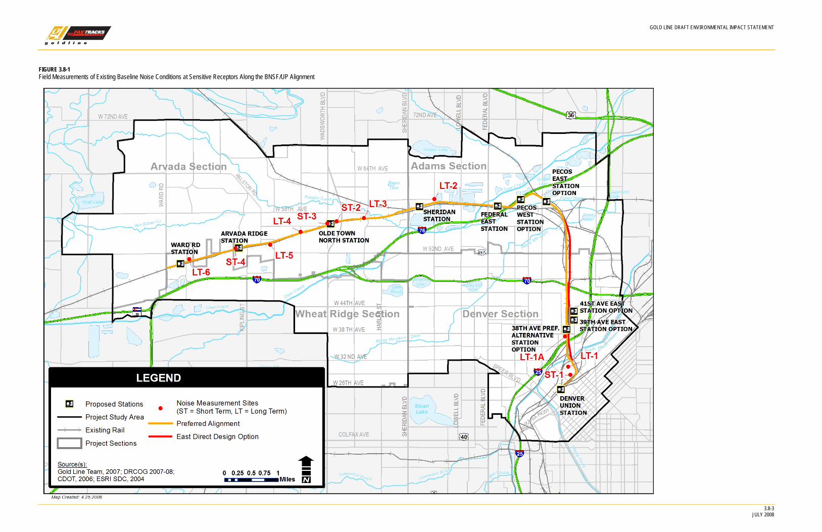
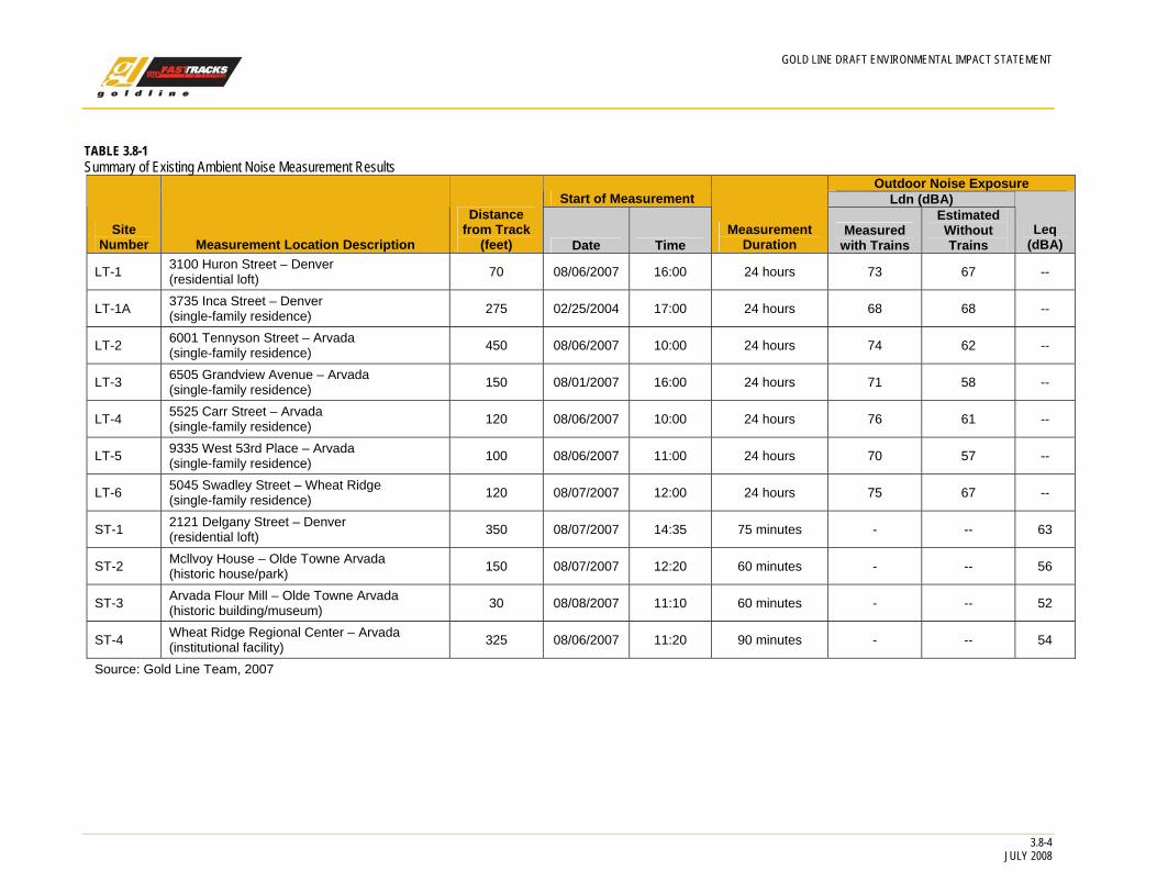
Measured Noise Levels To characterize the existing baseline noise conditions at sensitive receptors along the BNSF/UP alignment, a field measurement program was conducted at seven long term (24-hour measurements are taken) and four short term (1- to 2-hour observed measurements are taken) sites from August 1 through August 8, 2007. The general locations of these measurement sites are indicated in Figure 3.8-1.
GOLD LINE DRAFT ENVIRONMENTAL IMPACT STATEMENT
FIGURE 3.8-1 Field Measurements of Existing Baseline Noise Conditions at Sensitive Receptors Along the BNSF/UP Alignment
3.8-3 JULY 2008
GOLD LINE DRAFT ENVIRONMENTAL IMPACT STATEMENT
3.8-4 JULY 2008
TABLE 3.8-1 Summary of Existing Ambient Noise Measurement Results
Outdoor Noise Exposure Start of Measurement Ldn (dBA)
Site Number Measurement Location Description
Distance from Track
(feet) Date Time Measurement
Duration Measured
with Trains
Estimated Without Trains
Leq (dBA)
LT-1 3100 Huron Street – Denver (residential loft) 70 08/06/2007 16:00 24 hours 73 67 --
LT-1A 3735 Inca Street – Denver (single-family residence) 275 02/25/2004 17:00 24 hours 68 68 --
LT-2 6001 Tennyson Street – Arvada (single-family residence) 450 08/06/2007 10:00 24 hours 74 62 --
LT-3 6505 Grandview Avenue – Arvada (single-family residence) 150 08/01/2007 16:00 24 hours 71 58 --
LT-4 5525 Carr Street – Arvada (single-family residence) 120 08/06/2007 10:00 24 hours 76 61 --
LT-5 9335 West 53rd Place – Arvada (single-family residence) 100 08/06/2007 11:00 24 hours 70 57 --
LT-6 5045 Swadley Street – Wheat Ridge (single-family residence) 120 08/07/2007 12:00 24 hours 75 67 --
ST-1 2121 Delgany Street – Denver (residential loft) 350 08/07/2007 14:35 75 minutes - -- 63
ST-2 Mcllvoy House – Olde Towne Arvada (historic house/park) 150 08/07/2007 12:20 60 minutes - -- 56
ST-3 Arvada Flour Mill – Olde Towne Arvada (historic building/museum) 30 08/08/2007 11:10 60 minutes - -- 52
ST-4 Wheat Ridge Regional Center – Arvada (institutional facility) 325 08/06/2007 11:20 90 minutes - -- 54
Source: Gold Line Team, 2007
GOLD LINE DRAFT ENVIRONMENTAL IMPACT STATEMENT
3.8.1.3 Impact Evaluation The noise impact evaluation for the Preferred Alternative includes the effects of both the Gold Line project and the Northwest Rail project in the Denver Section. Noise impact methodology, results, and mitigation are discussed below.
Methodology Noise impact for the Gold Line project is based on criteria defined in the FTA guidance manual, Transit Noise and Vibration Impact Assessment (FTA, 2006b).
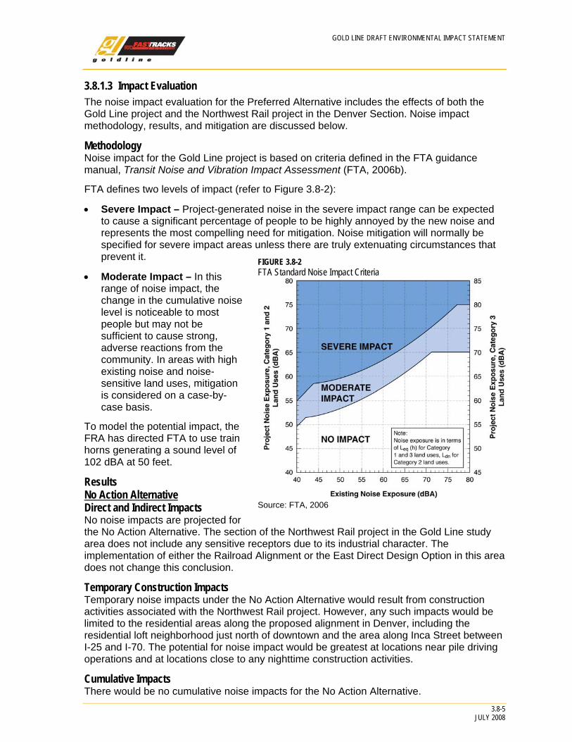
FTA defines two levels of impact (refer to Figure 3.8-2):
• Severe Impact – Project-generated noise in the severe impact range can be expected to cause a significant percentage of people to be highly annoyed by the new noise and represents the most compelling need for mitigation. Noise mitigation will normally be specified for severe impact areas unless there are truly extenuating circumstances that prevent it. FIGURE 3.8-2
FTA Standard Noise Impact Criteria
Source: FTA, 2006
• Moderate Impact – In this range of noise impact, the change in the cumulative noise level is noticeable to most people but may not be sufficient to cause strong, adverse reactions from the community. In areas with high existing noise and noise-sensitive land uses, mitigation is considered on a case-by-case basis.
To model the potential impact, the FRA has directed FTA to use train horns generating a sound level of 102 dBA at 50 feet.
Results No Action Alternative Direct and Indirect Impacts No noise impacts are projected for the No Action Alternative. The section of the Northwest Rail project in the Gold Line study area does not include any sensitive receptors due to its industrial character. The implementation of either the Railroad Alignment or the East Direct Design Option in this area does not change this conclusion.
Temporary Construction Impacts Temporary noise impacts under the No Action Alternative would result from construction activities associated with the Northwest Rail project. However, any such impacts would be limited to the residential areas along the proposed alignment in Denver, including the residential loft neighborhood just north of downtown and the area along Inca Street between I-25 and I-70. The potential for noise impact would be greatest at locations near pile driving operations and at locations close to any nighttime construction activities.
Cumulative Impacts There would be no cumulative noise impacts for the No Action Alternative.
3.8-5 JULY 2008
GOLD LINE DRAFT ENVIRONMENTAL IMPACT STATEMENT
3.8-6 JULY 2008
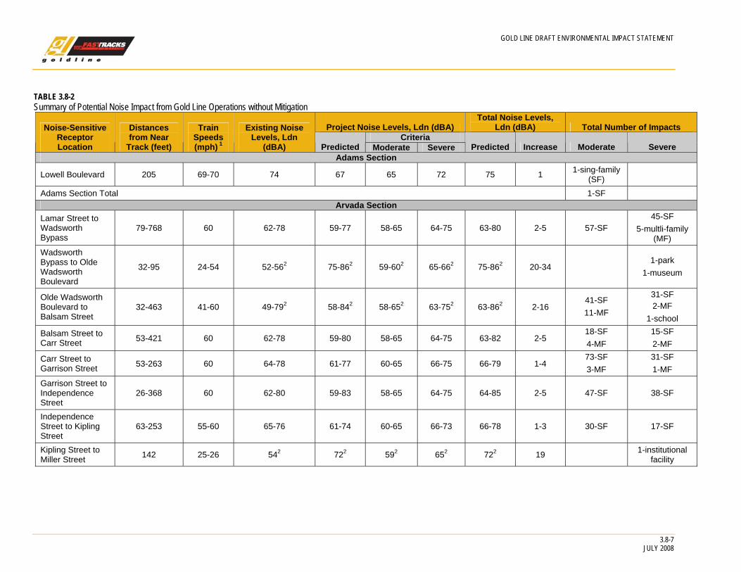
Preferred Alternative Direct Impacts Table 3.8-2 presents a summary of potential noise impacts at residential and institutional land uses along the Gold Line study area without mitigation. In general, the Preferred Alternative is located within existing railroad ROW between Pecos Street and Ward Road. The Gold Line trains would travel on their own dedicated tracks and would not share track with freight rail. The number and daily schedule of freight movements in 2030 are estimated to be similar to current 2008 conditions. Freight operations would not be increased or service hours changed as a result of implementing the Preferred Alternative. Therefore, the Gold Line would have no impact on freight operations or the noise associated with freight operations.
The projected impacts are identical for opening day 2015 and 2030 operations.
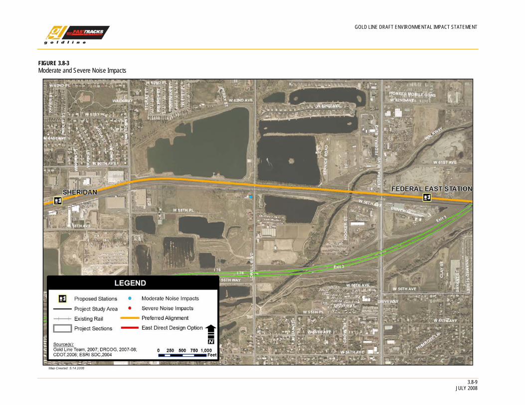
As shown on Figure 3.8-3, no noise impacts have been identified for the Denver Section of the study area.
Adams Section. Moderate noise impact is projected at only one single-family residence within this section, in the vicinity of the Lowell Boulevard grade crossing.
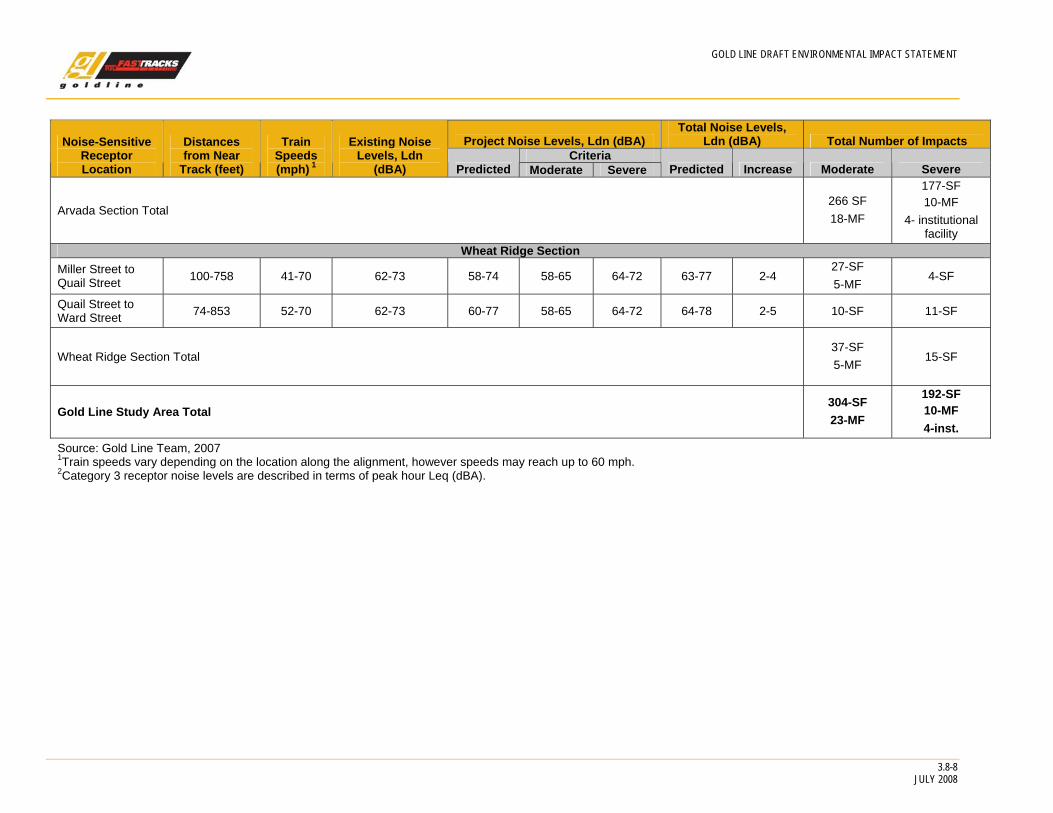
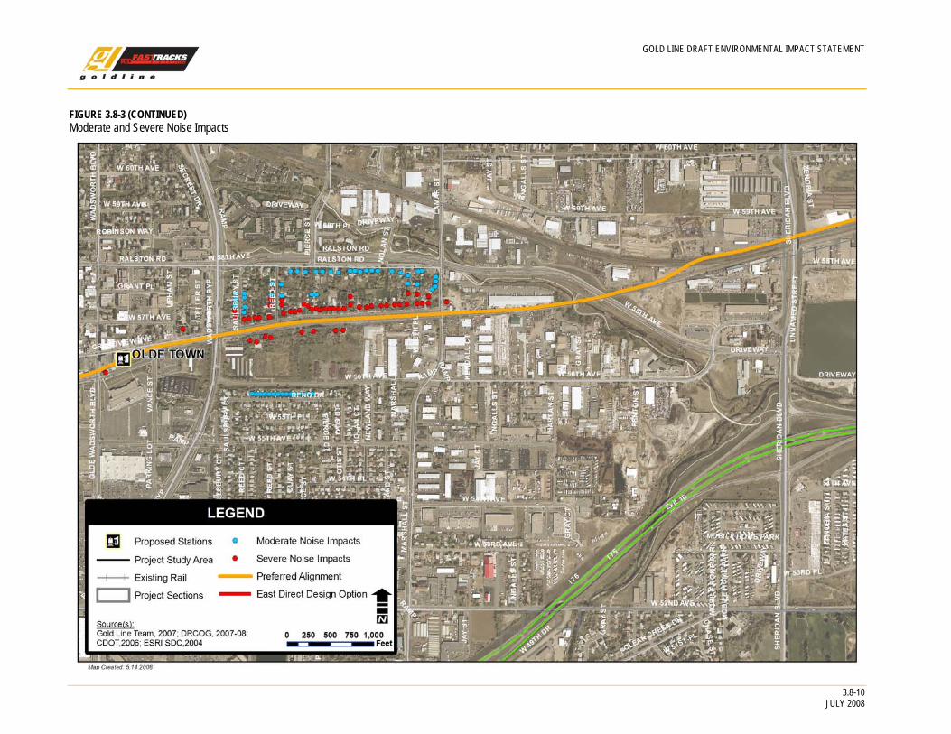
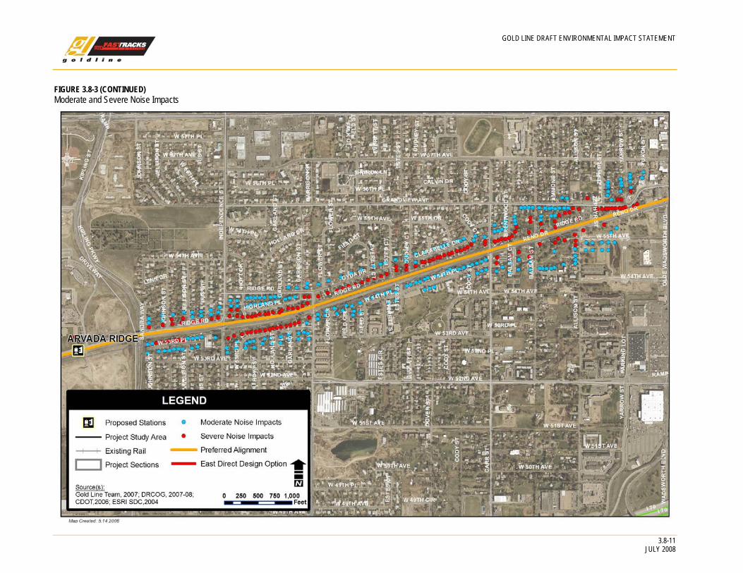
Arvada Section. Along the Arvada Section, severe noise impact is projected at 177 single-family homes, 10 multi-family buildings, one park building (Mcllvoy House), one museum (the Arvada Flour Mill), one school (Lawrence Elementary School), and one institutional facility (the Wheat Ridge Regional Center). Moderate noise impact is projected at 266 single-family homes and 18 multi-family residential buildings.
Wheat Ridge Section. Along the Wheat Ridge Section, severe noise impact is projected at 15 single-family homes and moderate noise impact is projected at 37 single-family residences and at five multi-family buildings.
Indirect Impacts No indirect noise impacts are projected for the Preferred Alternative.
Temporary Construction Impacts Temporary noise impacts under the Preferred Alternative would result from construction activities. Noise would result from utility relocation, grading, excavation, paving, installation of structures, and track work. Such impacts may occur in residential areas and at other noise-sensitive land uses located within several hundred feet of the alignment. The potential for noise impact would be greatest at locations near pile-driving operations for bridges and other structures and at locations close to any nighttime construction activities.
Cumulative Impacts There would be no cumulative noise impacts for the Preferred Alternative.
GOLD LINE DRAFT ENVIRONMENTAL IMPACT STATEMENT
TABLE 3.8-2 Summary of Potential Noise Impact from Gold Line Operations without Mitigation
Project Noise Levels, Ldn (dBA) Total Noise Levels,
Ldn (dBA) Total Number of Impacts Criteria
Noise-Sensitive Receptor Location
Distances from Near
Track (feet)
Train Speeds (mph) 1
Existing Noise Levels, Ldn
(dBA) Predicted Moderate Increase Moderate Predicted Severe Severe Adams Section
Lowell Boulevard 205 69-70 74 67 65 72 75 1 1-sing-family (SF)
Adams Section Total 1-SF Arvada Section
Lamar Street to Wadsworth Bypass
79-768 60 62-78 59-77 58-65 64-75 63-80 2-5 57-SF 45-SF
5-multli-family (MF)
Wadsworth Bypass to Olde Wadsworth Boulevard
32-95 24-54 52-562 75-862 59-602 65-662 75-862 20-34 1-park
1-museum
Olde Wadsworth Boulevard to Balsam Street
32-463 41-60 49-792 58-842 58-652 63-752 63-862 2-16 41-SF 11-MF
31-SF 2-MF
1-school
Balsam Street to Carr Street 53-421 60 62-78 59-80 58-65 64-75 63-82 2-5
18-SF 4-MF
15-SF 2-MF
Carr Street to Garrison Street 53-263 60 64-78 61-77 60-65 66-75 66-79 1-4
73-SF 3-MF
31-SF 1-MF
Garrison Street to Independence Street
26-368 60 62-80 59-83 58-65 64-75 64-85 2-5 47-SF 38-SF
Independence Street to Kipling Street
63-253 55-60 65-76 61-74 60-65 66-73 66-78 1-3 30-SF 17-SF
Kipling Street to Miller Street 142 25-26 542 722 592 652 722 19 1-institutional
facility
3.8-7 JULY 2008
GOLD LINE DRAFT ENVIRONMENTAL IMPACT STATEMENT
3.8-8 JULY 2008
Project Noise Levels, Ldn (dBA) Total Noise Levels,
Ldn (dBA) Total Number of Impacts Criteria
Noise-Sensitive Receptor Location
Distances from Near
Track (feet)
Train Speeds (mph) 1
Existing Noise Levels, Ldn
(dBA) Predicted Moderate Severe Predicted Increase Moderate Severe
Arvada Section Total 266 SF 18-MF
177-SF 10-MF
4- institutional facility
Wheat Ridge Section Miller Street to Quail Street 100-758 41-70 62-73 58-74 58-65 64-72 63-77 2-4
27-SF 5-MF
4-SF
Quail Street to Ward Street 74-853 52-70 62-73 60-77 58-65 64-72 64-78 2-5 10-SF 11-SF
Wheat Ridge Section Total
37-SF 5-MF
15-SF
Gold Line Study Area Total 304-SF 23-MF
192-SF 10-MF 4-inst.
Source: Gold Line Team, 2007 1Train speeds vary depending on the location along the alignment, however speeds may reach up to 60 mph. 2Category 3 receptor noise levels are described in terms of peak hour Leq (dBA).
GOLD LINE DRAFT ENVIRONMENTAL IMPACT STATEMENT
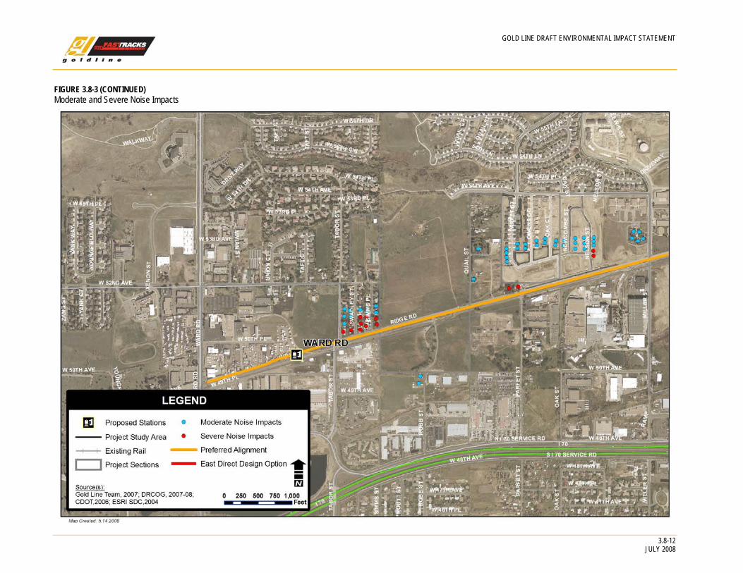
FIGURE 3.8-3 Moderate and Severe Noise Impacts
3.8-9 JULY 2008
GOLD LINE DRAFT ENVIRONMENTAL IMPACT STATEMENT
FIGURE 3.8-3 (CONTINUED) Moderate and Severe Noise Impacts
3.8-10 JULY 2008
GOLD LINE DRAFT ENVIRONMENTAL IMPACT STATEMENT
FIGURE 3.8-3 (CONTINUED) Moderate and Severe Noise Impacts
3.8-11 JULY 2008
GOLD LINE DRAFT ENVIRONMENTAL IMPACT STATEMENT
3.8-12 JULY 2008
Moderate and Severe Noise Impacts
FIGURE 3.8-3 (CONTINUED)
GOLD LINE DRAFT ENVIRONMENTAL IMPACT STATEMENT
3.8.1.4 Mitigation Measures According to FTA regulations, when implementing noise impact criteria, severe impacts should be mitigated if at all practical. For mitigation at the moderate impact level, more discretion should be used and other project-specific factors should be included. These factors can include the predicted increase over existing noise levels, the types and number of noise-sensitive land uses affected, existing outdoor-to-indoor sound insulation, and the cost-effectiveness of mitigating the noise. However, FTA also states that there is a stronger need for mitigation if a project is proposed in an area currently experiencing high noise levels (for example, with Ldn above 65 dBA) from surface transportation sources. This is the case along the Arvada and Wheat Ridge sections of the Gold Line study area. In these areas, the existing noise exposure is dominated by existing BNSF Railway Company freight trains, with Ldn levels close to the track typically ranging from 70 dBA to 80 dBA. In such cases, FTA indicates that impacts predicted in the moderate range should be treated as if they were severe in terms of mitigation.
Quiet Zone A Quiet Zone is an area where crossings of the rail line include sufficient safety mechanisms so that trains are not required to sound their horns when crossing. Quiet Zones need to be implemented by local government through approvals from the Public Utilities Commission (PUC), FRA, and the railroads. RTD can assist but cannot lead the effort to implement a Quiet Zone.
In view of the above considerations, the mitigation approach will, wherever practical, mitigate predicted noise impacts. The results of the noise analysis suggest that the most effective mitigation measure would be to establish Quiet Zones from the Lowell Boulevard grade crossing to the Tabor Street grade crossing in Wheat Ridge.
It should be noted that because the ROW is narrow and the noise impact is dominated by train horns, near the numerous grade crossings, noise barriers would not be reasonable and feasible. Therefore, they are not considered to be an appropriate noise mitigation approach for the Gold Line corridor. Even in the areas where there might be enough space for barriers, their effectiveness would be limited due to the necessary breaks at each grade crossing. In addition, noise barriers would generate secondary (e.g. visual) impacts and would not likely be acceptable to the community and local governments.
As shown in Table 3.8.3, it is expected that this measure would eliminate all of the projected noise impacts along the corridor, except for one museum (the Arvada Flour Mill). However, the residual moderate noise impact is marginal and not practical to mitigate at this location due to the close proximity of the museum to the Olde Wadsworth Boulevard grade crossing. It should also be noted that because the horn noise from existing and future freight train operations would be eliminated, it is estimated that Quiet Zones would significantly lower the total noise exposure along this section of the corridor, with reductions in Ldn ranging from two to twelve decibels. As mentioned earlier, 2030 freight operations are estimated to be similar to existing freight operations.
Considering the above factors, quiet zone implementation is the recommended noise mitigation measure for the Gold Line corridor. As stated in “The Responsible Rail Amendment,” RTD is committed to assisting local jurisdictions in their quiet zone application process. For the Gold Line, RTD is making progress toward implementing quiet zones with diagnostics being done during the summer of 2008. However, should quiet zones not be implemented, the secondary plan is to install wayside horns and provide further mitigation (e.g. sound insulation) if practical to mitigate any residual impacts. In that case, an analysis of the actual effectiveness of wayside horns and other mitigation measures, such as building insulation, will be conducted and the results will be reported in the FEIS.
3.8-13 JULY 2008
GOLD LINE DRAFT ENVIRONMENTAL IMPACT STATEMENT
3.8-14 JULY 2008
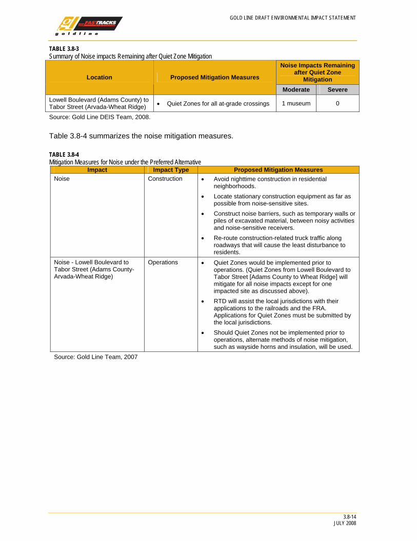
TABLE 3.8-3 Summary of Noise impacts Remaining after Quiet Zone Mitigation
Noise Impacts Remaining after Quiet Zone
Mitigation Location Proposed Mitigation Measures
Moderate Severe Lowell Boulevard (Adams County) to Tabor Street (Arvada-Wheat Ridge) • Quiet Zones for all at-grade crossings 1 museum 0
Source: Gold Line DEIS Team, 2008.
Table 3.8-4 summarizes the noise mitigation measures.
TABLE 3.8-4 Mitigation Measures for Noise under the Preferred Alternative
Impact Impact Type Proposed Mitigation Measures Noise Construction • Avoid nighttime construction in residential
neighborhoods. • Locate stationary construction equipment as far as
possible from noise-sensitive sites. • Construct noise barriers, such as temporary walls or
piles of excavated material, between noisy activities and noise-sensitive receivers.
• Re-route construction-related truck traffic along roadways that will cause the least disturbance to residents.
Noise - Lowell Boulevard to Tabor Street (Adams County-Arvada-Wheat Ridge)
Operations • Quiet Zones would be implemented prior to operations. (Quiet Zones from Lowell Boulevard to Tabor Street [Adams County to Wheat Ridge] will mitigate for all noise impacts except for one impacted site as discussed above).
• RTD will assist the local jurisdictions with their applications to the railroads and the FRA. Applications for Quiet Zones must be submitted by the local jurisdictions.
• Should Quiet Zones not be implemented prior to operations, alternate methods of noise mitigation, such as wayside horns and insulation, will be used.
Source: Gold Line Team, 2007
GOLD LINE DRAFT ENVIRONMENTAL IMPACT STATEMENT
3.8-15 JULY 2008
3.8.2 Vibration
3.8.2.1 Introduction to Analysis
Summary of Results For the Preferred Alternative, potential vibration impacts are projected at a total of 18 single-family residences. All of these residences are located within about 50 feet of the proposed alignment near track in Arvada and are identical for opening day 2015 and 2030 operations. It is expected that these impacts would be mitigated with a combination of track vibration isolation treatments and track turnout modifications.
Other than the potential for some temporary vibration impacts in the Denver Section during construction of the Northwest Rail project, no additional vibration impacts are anticipated for the No Action Alternative.
Purpose Vibration assessments are key elements of the environmental impact assessment process for mass transit projects.3 Vibration impacts are also a concern due to the close proximity of the Preferred Alternative to the three historic districts in Arvada.
Vibration Fundamentals and Descriptors Vibration is a fine movement or low rumble that is radiated through the ground and is felt in the motion of room surfaces. The unit of measure is VdB, which is used to measure vibration-related decibels. Typical background vibration is about 52 VdB. By comparison, a bulldozer would cause vibration of approximately 92 VdB. The limit of vibration-sensitive equipment is about 65 VdB, and the planning threshold for residential annoyance is 72 VdB.
3.8.2.2 Affected Environment
Overview The vibration-sensitive receptors in each section of the Gold Line study area are essentially the same as the noise-sensitive receptors. The only significant existing sources of ground-borne vibration along the proposed alignment are freight trains, which operate along the alignment from DUS to Ward Road. As mentioned previously, the Arvada and Wheat Ridge sections of the alignment are the most sensitive to vibration due to the proximity of sensitive land uses to the freight tracks. From 4 to 5 freight operations occur daily in these sections. Future 2030 freight operations are estimated to be comparable to existing 2008 operations.
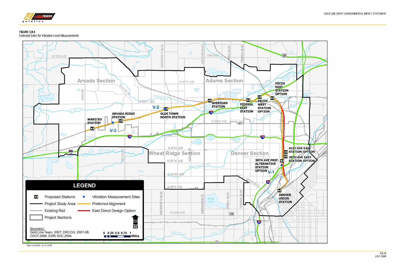
Measured Vibration Levels To characterize the existing baseline vibration conditions at sensitive receptors along the proposed alignment, a field measurement program was conducted from August 1 to 2, 2007. The program consisted of ground vibration propagation tests as well as vibration measurements during train operations in representative areas. Figure 3.8-4 shows three sites, designated as Sites V-1 through V-3, were selected to represent the range of soil conditions in areas along the proposed alignment. Measurements were not provided in the Adams Section due to the industrial character of the alignment. Vibration measurement sites are described below:
• Site V-1 (Denver) – This location was selected to represent the vibration propagation conditions at the southern end of the project in the Denver Section.
3 FTA Transit Noise and Vibration Impact Assessment. FTA-VA-90-1003-06. May 2006.
3.8-16
GOLD LINE DRAFT ENVIRONMENTAL IMPACT STATEMENT
JULY 2008
Selected Sites for Vibration Level Measurements FIGURE 3.8-4
GOLD LINE DRAFT ENVIRONMENTAL IMPACT STATEMENT
3.8-17 JULY 2008
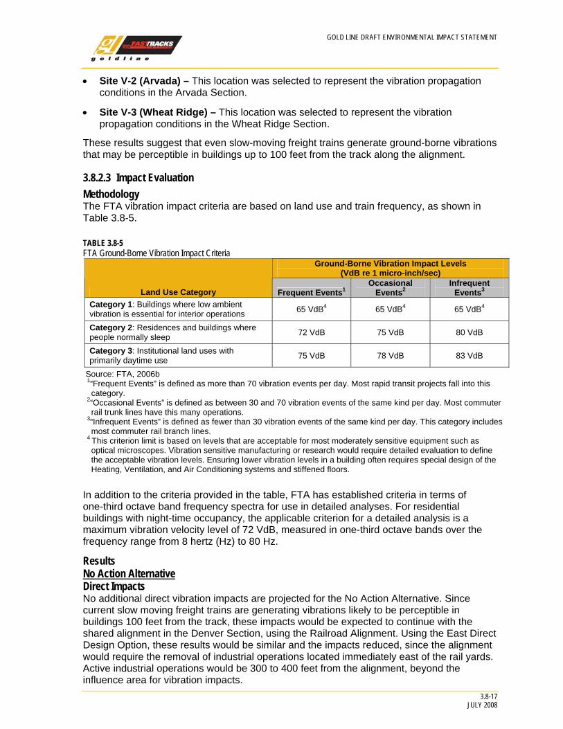
• Site V-2 (Arvada) – This location was selected to represent the vibration propagation conditions in the Arvada Section.
• Site V-3 (Wheat Ridge) – This location was selected to represent the vibration propagation conditions in the Wheat Ridge Section.
These results suggest that even slow-moving freight trains generate ground-borne vibrations that may be perceptible in buildings up to 100 feet from the track along the alignment.
3.8.2.3 Impact Evaluation
Methodology The FTA vibration impact criteria are based on land use and train frequency, as shown in Table 3.8-5.
TABLE 3.8-5 FTA Ground-Borne Vibration Impact Criteria
Ground-Borne Vibration Impact Levels (VdB re 1 micro-inch/sec)
Land Use Category Frequent Events1 Occasional
Events2 Infrequent
Events3 Category 1: Buildings where low ambient vibration is essential for interior operations 65 VdB4 65 VdB4 65 VdB4
Category 2: Residences and buildings where people normally sleep 72 VdB 75 VdB 80 VdB
Category 3: Institutional land uses with primarily daytime use 75 VdB 78 VdB 83 VdB
Source: FTA, 2006b 1“Frequent Events” is defined as more than 70 vibration events per day. Most rapid transit projects fall into this category.
2“Occasional Events” is defined as between 30 and 70 vibration events of the same kind per day. Most commuter rail trunk lines have this many operations.
3“Infrequent Events” is defined as fewer than 30 vibration events of the same kind per day. This category includes most commuter rail branch lines.
4 This criterion limit is based on levels that are acceptable for most moderately sensitive equipment such as optical microscopes. Vibration sensitive manufacturing or research would require detailed evaluation to define the acceptable vibration levels. Ensuring lower vibration levels in a building often requires special design of the Heating, Ventilation, and Air Conditioning systems and stiffened floors.
In addition to the criteria provided in the table, FTA has established criteria in terms of one-third octave band frequency spectra for use in detailed analyses. For residential buildings with night-time occupancy, the applicable criterion for a detailed analysis is a maximum vibration velocity level of 72 VdB, measured in one-third octave bands over the frequency range from 8 hertz (Hz) to 80 Hz.
Results No Action Alternative Direct Impacts No additional direct vibration impacts are projected for the No Action Alternative. Since current slow moving freight trains are generating vibrations likely to be perceptible in buildings 100 feet from the track, these impacts would be expected to continue with the shared alignment in the Denver Section, using the Railroad Alignment. Using the East Direct Design Option, these results would be similar and the impacts reduced, since the alignment would require the removal of industrial operations located immediately east of the rail yards. Active industrial operations would be 300 to 400 feet from the alignment, beyond the influence area for vibration impacts.
GOLD LINE DRAFT ENVIRONMENTAL IMPACT STATEMENT
3.8-18 JULY 2008
Indirect Impacts No indirect vibration impacts are projected for the No Action Alternative.
Temporary Construction Impacts Temporary vibration impacts under the No Action Alternative would result from construction activities associated with the Northwest Rail project. However, any such impacts would be limited to the residential areas along the alignment in Denver, including the residential loft neighborhood just north of downtown and the area along Inca Street between I-25 and I-70. The potential for vibration impact would be greatest at locations near pile driving and vibratory compactor operations.
Cumulative Impacts There would be no cumulative vibration impacts for the No Action Alternative.
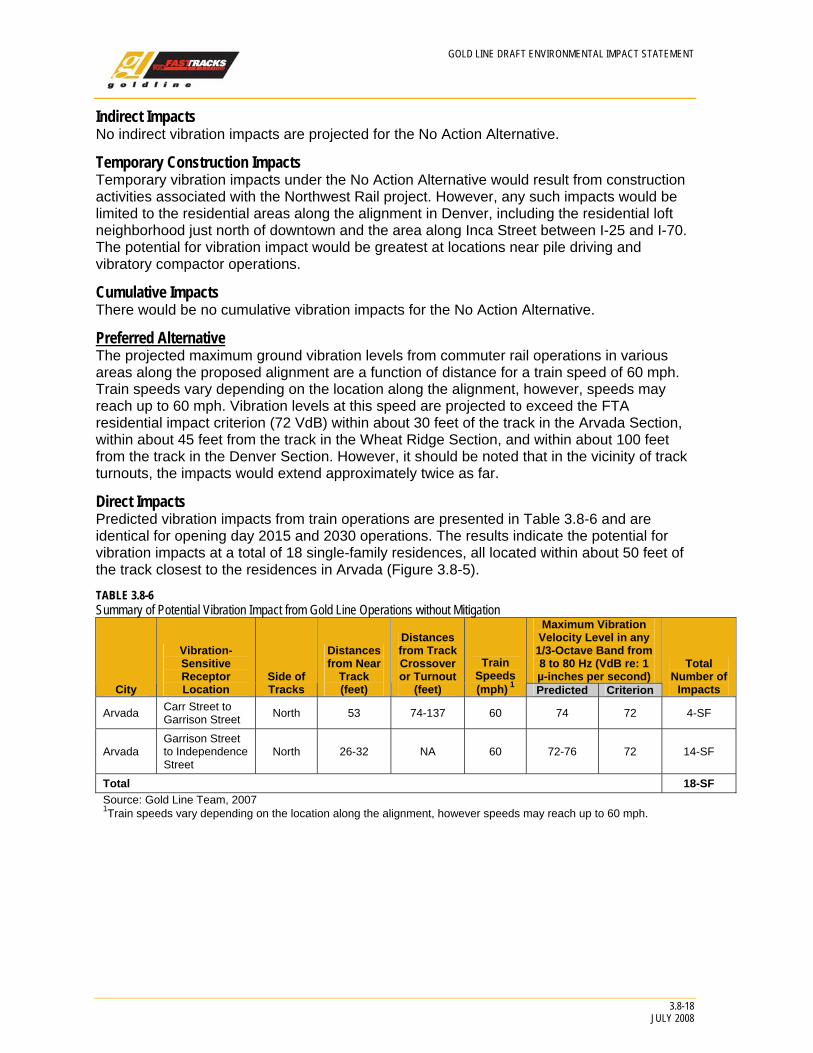
Preferred Alternative The projected maximum ground vibration levels from commuter rail operations in various areas along the proposed alignment are a function of distance for a train speed of 60 mph. Train speeds vary depending on the location along the alignment, however, speeds may reach up to 60 mph. Vibration levels at this speed are projected to exceed the FTA residential impact criterion (72 VdB) within about 30 feet of the track in the Arvada Section, within about 45 feet from the track in the Wheat Ridge Section, and within about 100 feet from the track in the Denver Section. However, it should be noted that in the vicinity of track turnouts, the impacts would extend approximately twice as far.
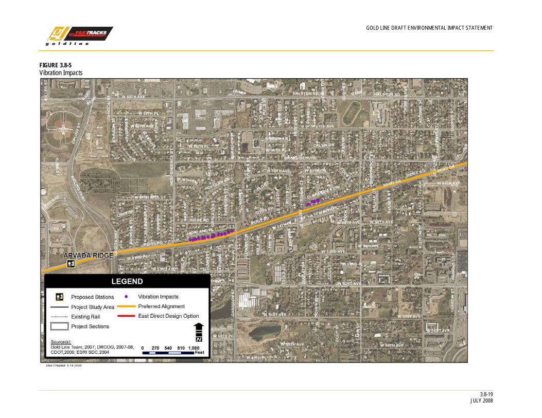
Direct Impacts Predicted vibration impacts from train operations are presented in Table 3.8-6 and are identical for opening day 2015 and 2030 operations. The results indicate the potential for vibration impacts at a total of 18 single-family residences, all located within about 50 feet of the track closest to the residences in Arvada (Figure 3.8-5).
TABLE 3.8-6 Summary of Potential Vibration Impact from Gold Line Operations without Mitigation
Maximum Vibration Velocity Level in any 1/3-Octave Band from 8 to 80 Hz (VdB re: 1 µ-inches per second)
City
Vibration-Sensitive Receptor Location
Side of Tracks
Distances from Near
Track (feet)
Distances from Track Crossover or Turnout
(feet)
Train Speeds (mph) 1 Predicted Criterion
Total Number of
Impacts
Arvada Carr Street to Garrison Street North 53 74-137 60 74 72 4-SF
Arvada Garrison Street to Independence Street
North 26-32 NA 60 72-76 72 14-SF
Total 18-SF Source: Gold Line Team, 2007 1Train speeds vary depending on the location along the alignment, however speeds may reach up to 60 mph.
3.8-19
GOLD LINE DRAFT ENVIRONMENTAL IMPACT STATEMENT
JULY 2008
Vibration Impacts FIGURE 3.8-5
GOLD LINE DRAFT ENVIRONMENTAL IMPACT STATEMENT
3.8-20 JULY 2008
Indirect Impacts No indirect vibration impacts are projected for the Preferred Alternative.
Temporary Construction Impacts Temporary vibration impacts under the Preferred Alternative would result from construction activities associated with utility relocation, grading, excavation, track work, and installation of structures and systems components. Such impacts may occur in residential areas and at other vibration-sensitive land uses located near the proposed alignment. The potential for vibration impact would be greatest at locations near pile driving for bridges and other structures and at locations close to vibratory compactor operations.
Cumulative Impacts No cumulative vibration impacts are projected for the Preferred Alternative.
3.8.2.4 Mitigation Measures Beyond ensuring that the vehicle wheels and track are well maintained, approaches that can be considered to reduce ground-borne vibration from train operation include track vibration isolation treatments such as ballast mats, under-tie pads, and floating slab track. Near turnouts, vibration from wheel impacts can be reduced by using special hardware (such as spring-rail or moveable-point frogs in place of standard rigid frogs) if the turnouts cannot be relocated away from sensitive areas.
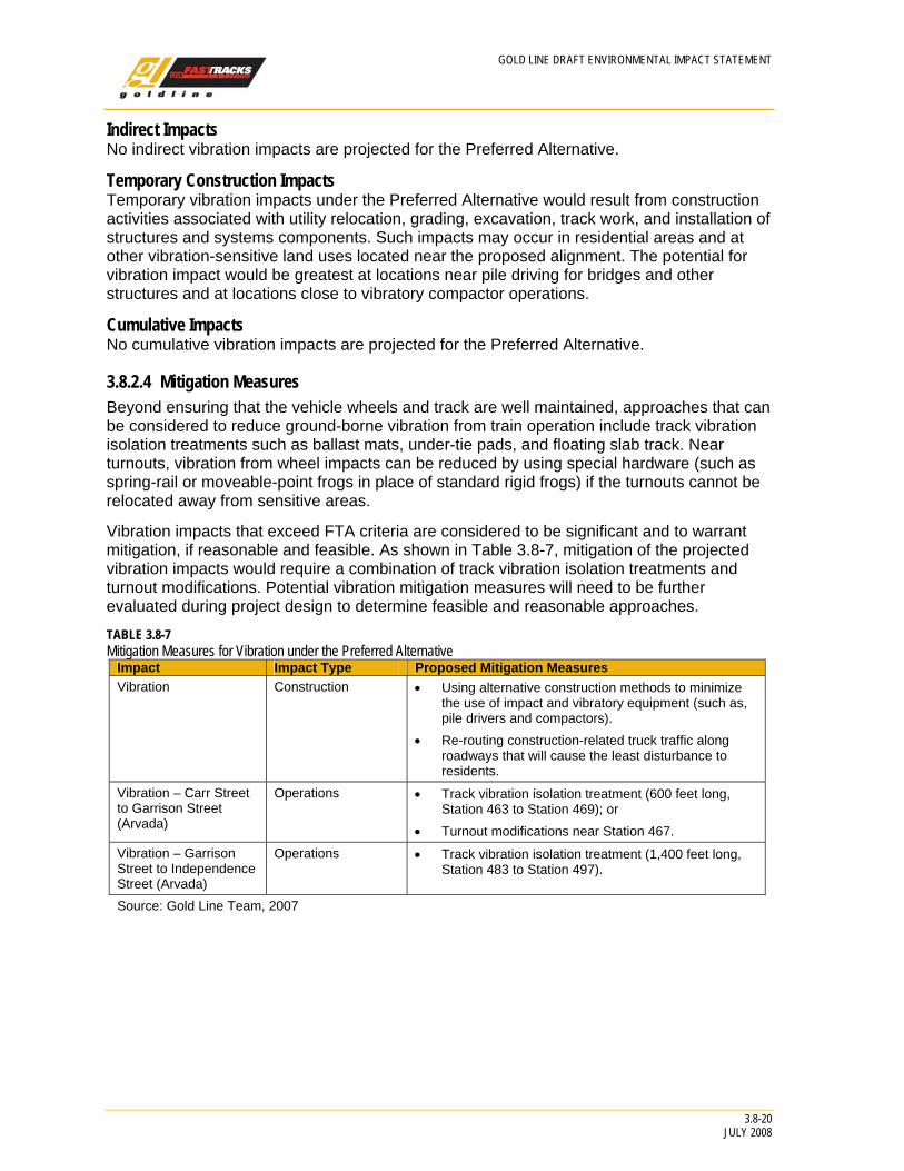
Vibration impacts that exceed FTA criteria are considered to be significant and to warrant mitigation, if reasonable and feasible. As shown in Table 3.8-7, mitigation of the projected vibration impacts would require a combination of track vibration isolation treatments and turnout modifications. Potential vibration mitigation measures will need to be further evaluated during project design to determine feasible and reasonable approaches.
TABLE 3.8-7 Mitigation Measures for Vibration under the Preferred Alternative
Impact Impact Type Proposed Mitigation Measures Vibration Construction • Using alternative construction methods to minimize
the use of impact and vibratory equipment (such as, pile drivers and compactors).
• Re-routing construction-related truck traffic along roadways that will cause the least disturbance to residents.
Vibration – Carr Street to Garrison Street (Arvada)
Operations • Track vibration isolation treatment (600 feet long, Station 463 to Station 469); or
• Turnout modifications near Station 467. Vibration – Garrison Street to Independence Street (Arvada)
Operations • Track vibration isolation treatment (1,400 feet long, Station 483 to Station 497).
Source: Gold Line Team, 2007
3.9B
iological Resources
GOLD LINE DRAFT ENVIRONMENTAL IMPACT STATEMENT
3.9 Biological Resources
3.9.1 Introduction to Analysis
3.9.1.1 Summary of Results No areas of high-quality habitat or listed endangered or threatened species would be affected by the implementation of the Preferred Alternative. The majority of the direct impacts on vegetation and wildlife would occur during construction at bridge crossings where about 1 acre of riparian vegetation would be disturbed. Most of the area of direct permanent effect would occur in habitats that have already been heavily modified by human activity such as railroad ROW and industrial, commercial, and residential areas. Security fencing and retaining walls are not likely to affect any important areas for wildlife movement. The proposed track would be adjacent to existing track and would not cause a new division of previously contiguous habitat.
Minimal impacts to biological resources are expected as a result of the No Action Alternative. Project-specific environmental analysis would also evaluate impacts associated with these projects. While the Northwest Rail project would cross the South Platte River and Clear Creek, habitat disturbances are minimal because the alignment would be adjacent to an existing, operating freight rail line. Under the No Action Alternative, there would be no transit stations, or their associated impacts, in the Gold Line study area.
3.9.1.2 Purpose Construction of infrastructure projects can result in the loss of ecosystems and displacement of wildlife, even in urban settings. Many of these resources are protected by statutes, executive orders, and regulations.1 The purpose of this section is to evaluate impacts on biological resources, including wildlife, fish, and their habitats.
3.9.2 Affected Environment The Gold Line study area is primarily urban with no highly sensitive habitats present. Habitats that are present are discussed in Table 3.9-1 and generally support species that have adapted to urban and disturbed environments.
Throughout the Gold Line study area, 21 species of noxious weeds were observed during field surveys in 2003 and 2006. A full list of noxious weeds is provided in the biological resources technical memorandum.
Raptors were observed flying in the Gold Line study area, but no nests were observed.
1NEPA, CEQ Regulations, Endangered Species Act, Fish and Wildlife Coordination Act, Migratory Bird Treaty Act, Executive Order Protecting Migratory Birds, Executive Order for Invasive Species, Colorado Noxious Weed Management Act, State of Colorado Executive Order on Noxious Weed Management Programs.
3.9-1 JULY 2008
GOLD LINE DRAFT ENVIRONMENTAL IMPACT STATEMENT
3.9-2 JULY 2008
TABLE 3.9-1 Habitats in the Gold Line Study Area
Habitat Description Location Industrial and commercial
Disturbed area with buildings, pavement, and bare ground
Throughout the Gold Line study area
Residential and parks Buildings, pavement, and irrigated landscape
Throughout the Gold Line study area
Grasslands Areas dominated by grasses and other herbaceous species
South Platte River, I-76, Clear Creek, Lake Sangraco, Jim Baker Reservoir, and Lake Carol Anne
Wetland riparian Scrub-shrub and mixed shrub/emergent vegetation
South Platte River, Clear Creek, Ralston Creek, and Jim Baker Reservoir
Riparian woodland Mesic areas dominated by trees and shrubs
South Platte River, Fisher Ditch, Clear Creek, Jim Baker Reservoir, and Lake Carol Anne
Marsh Wetlands dominated by emergent vegetation
Clear Creek and Jim Baker Reservoir
Aquatic habitat Rivers, streams, ponds, and lakes
South Platte River, Clear Creek, Lake Sangraco, Jim Baker Reservoir, and Lake Carol Anne
Sensitive habitats and wildlife corridors
Natural and semi-natural areas allowing wildlife movement
South Platte River, Clear Creek, and Ralston Creek
Source: Gold Line Team, 2007
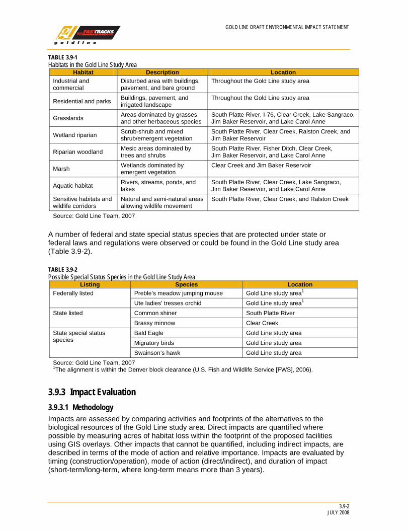
A number of federal and state special status species that are protected under state or federal laws and regulations were observed or could be found in the Gold Line study area (Table 3.9-2).
TABLE 3.9-2 Possible Special Status Species in the Gold Line Study Area
Listing Species Location Preble’s meadow jumping mouse Gold Line study area1 Federally listed Ute ladies’ tresses orchid Gold Line study area1 Common shiner South Platte River State listed Brassy minnow Clear Creek Bald Eagle Gold Line study area Migratory birds Gold Line study area
State special status species
Swainson’s hawk Gold Line study area Source: Gold Line Team, 2007 1The alignment is within the Denver block clearance (U.S. Fish and Wildlife Service [FWS], 2006).
3.9.3 Impact Evaluation
3.9.3.1 Methodology Impacts are assessed by comparing activities and footprints of the alternatives to the biological resources of the Gold Line study area. Direct impacts are quantified where possible by measuring acres of habitat loss within the footprint of the proposed facilities using GIS overlays. Other impacts that cannot be quantified, including indirect impacts, are described in terms of the mode of action and relative importance. Impacts are evaluated by timing (construction/operation), mode of action (direct/indirect), and duration of impact (short-term/long-term, where long-term means more than 3 years).
GOLD LINE DRAFT ENVIRONMENTAL IMPACT STATEMENT
3.9-3 JULY 2008
3.9.3.2 Results
No Action Alternative The No Action Alternative assumes that existing and committed improvements, as defined in Chapter 2, Alternatives Considered, would be implemented by others as planned.
Direct Impacts Roadway Projects Implementation of the Sheridan Boulevard roadway project would add capacity to an existing major four-lane arterial through a heavily commercial area. Willis Case Golf Course is just southeast of the project. Otherwise, little vegetation is available for habitat in the project area itself. The vegetation that is present consists of small landscaped areas and small open areas with sparse weed cover. Impacts to the urban wildlife and its habitat would be negligible.
Implementation of the I-70/Kipling interchange roadway project is close to Fruitdale Park. Other wildlife habitat is scarce. Mowed grassland surrounds the existing interchange. It is probable that construction would not directly affect the park because it is approximately 330 feet from the nearest existing ramp and 800 feet from the center of the existing interchange.
The Wadsworth Boulevard roadway project also involves an existing major four-lane arterial through a heavily commercial area. Implementation of the Wadsworth Boulevard roadway project may involve a sliver acquisition of the Town Center Park, which provides landscaped habitat for some urban wildlife. The Wadsworth Boulevard roadway improvement area has extensive hardscape that would not provide high-quality habitat.
Northwest Rail Project From DUS to Pecos Street, the Northwest Rail project would either follow the Railroad Alignment within the railroad ROW or the East Direct Design Option, which would be located adjacent to the rail yards on industrial property and includes no wildlife habitat. The alignment would cross the South Platte River floodplain, which is industrial with highly disturbed habitat, resulting in minimal impacts to riparian habitat.
Although the proposed alignment would be adjacent to open space and Little Dry Creek Lake Park in the northern section of the Gold Line study area, the impacts would be expected to be minimal because construction would be limited to the highly disturbed freight railroad ROW and the presence of the adjacent active freight rail system.
Indirect Impacts Movement through the area may be affected by the increased pavement widths, thereby making the ability to move across the roadway more difficult.
Temporary Construction Impacts The construction impacts from the Sheridan Boulevard, Wadsworth Boulevard, the I-70/Kipling Interchange roadway and Northwest Rail improvement projects are the same as the direct impacts referenced above. Due to the urban and industrial character of the respective project areas, and the absence of productive wildlife habitat, no construction impacts to biological resources are expected.
Cumulative Impacts Under the No Action Alternative, the projected population increase of 17 percent within the Gold Line study area would place additional demands on vacant properties and open space. Urban development is anticipated to be more dispersed with the No Action Alternative than with the Preferred Alternative, as there would be no TOD. These population increases would
GOLD LINE DRAFT ENVIRONMENTAL IMPACT STATEMENT
3.9-4 JULY 2008
result in the development of new housing and businesses on vacant lands, as well as increased use of existing parks and open space by more users. Over time, less property would be available for wildlife habitat, and wildlife would be forced farther to the fringes of development.
Preferred Alternative Direct Impacts Vegetation/Habitats Direct impacts to vegetation and habitat from the Preferred Alternative would primarily result from clearing vegetation and earth moving for bridge construction at the crossings of Clear Creek and Ralston Creek. Depending on final engineering, the amount of vegetation would range from 0.25 to 0.50 acre at each crossing, or no more than 1 acre total. Most impacts would be temporary, and vegetation would be re-established after construction.
Construction at the stations would be permanent, with vacant land being replaced by the track and station facilities.
Most of the area of direct permanent effect would occur in habitats that have already been heavily modified by human activity including industrial, commercial, and residential areas that do not have unique or sensitive wildlife or plants. Construction of the facilities would have limited long-term effects in these areas because they are already modified. Although urban wildlife may be abundant in residential areas, it typically consists of a somewhat limited number of species that are highly tolerant of human activity. These areas are considered to have low sensitivity to disturbance.
The Olde Town Station location includes a small area (<1 acre) of riparian woodland associated with seepage areas and adjacent grassland. The development of a station at that location would result in very small (<1 acre) loss of habitat. There is no valuable habitat at the 38th Avenue, 39th Avenue East, 41st Avenue East, Pecos East or West, Federal, Sheridan, Arvada Ridge, or Ward Road Station locations.
Wildlife As discussed above, permanent habitat loss would result from replacement of existing vacant land by track or station facilities. Wildlife corridors are focused in the riparian corridors along Clear Creek and Ralston Creek. The design of the new bridges would not cause any reduction in the ability of wildlife to move through these areas. Bike paths are present on one side of the two stream crossings, and most wildlife movement is likely to occur at night or other times of low human activity. No other sensitive habitats would be affected.
Direct mortality of small terrestrial and burrowing animals during traffic/train movement (roadkill) may occur. RTD is currently developing a fencing plan that would include an analysis of fencing and wildlife impacts and provide recommendations for fencing appropriate to the environment.
Fish and Aquatic Habitats The Preferred Alternative would involve construction of new bridges across two streams and construction within 100 feet of lake habitats at Lake Sangraco and Jim Baker Reservoir. In-stream construction would be limited to one drilled pier in Ralston Creek. Fish and other aquatic species would vacate the immediate area during construction but would return post construction. The two bridges would shade a portion of the streams. Because of the limited tree shade under current conditions, the effects of bridge shading are likely to be beneficial.
GOLD LINE DRAFT ENVIRONMENTAL IMPACT STATEMENT
3.9-5 JULY 2008
Special Status Species The Preferred Alternative would have no effects on federally-listed endangered or threatened species. Although the proposed alignment and station locations are in the historic ranges of the Ute ladies’ tresses or Preble’s meadow jumping mouse, no occurrences of these species were identified in the Gold Line study area. There would be no water depletion effects on threatened or endangered species downstream in Nebraska.
Indirect Impacts The principal indirect effect of the Preferred Alternative would be from increased urban density caused by the TOD around the proposed transit stations. The majority of impact would be within 0.50 mile of the station platforms.
The transformation from low-density to higher-density development would reduce the amount of open and vacant areas around some station sites. Reductions of grassland, vacant industrial land, and riparian woodland in the area would reduce or change wildlife populations in these areas. The effects of induced growth may be most pronounced around the Pecos and Federal Stations because of the large amount of vacant land surrounding them and the presence of Clear Creek. Species associated with open land and lower levels of human disturbance may be reduced, while there would be little adverse effect on more tolerant and adaptable urban species. Increased development around the 38th Avenue, Sheridan, Olde Town, Arvada Ridge, and Ward Road Station sites would not change habitat because the areas are already developed for industrial, commercial, or residential uses.
Temporary Construction Impacts Construction activity would temporarily displace animals from the construction zone due to noise, human presence, and heavy equipment. However, this is not a major issue due to the urbanized nature of the Gold Line study area. Impacts would be temporary and would not affect long-term use of the areas. Less mobile animals may be crushed during earthwork and clearing, and other animals may die from collisions with equipment. Revegetation would restore habitat following construction.
Construction near the creeks and lakes may result in releases of sediment or chemicals into the water. Erosion and spills would be prevented by use of various water quality BMPs and effects on fish habitat are expected to be negligible or less. Use of game trails by wildlife along creeks may be temporarily disrupted during construction, but would be expected to resume when construction is complete.
Noxious Weeds Project-related construction may introduce new noxious weeds into the project area or increase the abundance of existing noxious weeds. These activities include the mobilization of construction vehicles, excavation and transport of borrow material and topsoil, land clearing, and reclamation. Removal of existing vegetation and disturbance of soils encourages germination of weed seeds and the spread of roots and seeds. Airborne seeds from noxious weeds in adjacent areas may seed areas where vegetation has been removed. After construction, noxious weeds can persist or become established in reclaimed areas. Noxious weeds that are present in the construction ROW can spread to adjacent lands. The primary concerns with noxious weeds are effects on public land, including open space, sensitive areas, agriculture, wetlands, and degradation of riparian habitat.
The primary concerns are common noxious species that are likely to spread within and from the construction area. For example, purple loosestrife is known to occur in the project area. Canada thistle, perennial pepperweed, and Russian olive are likely to invade wetland and riparian areas, and all of these species can invade upland areas.
GOLD LINE DRAFT ENVIRONMENTAL IMPACT STATEMENT
3.9-6 JULY 2008
Cumulative Impacts The cumulative impact of the Preferred Alternative would be similar to the No Action Alternative. Vacant land that now serves as generally marginal wildlife habitat would continue to be developed as the population increases by the year 2030. However, the TOD stimulated by the Preferred Alternative would slightly modify this trend because some percentage of the new development would occur at higher densities. This would have a modest positive effect on wildlife as some vacant land would not be developed during the planning period.
3.9.4 Avoidance and Minimization The design of the Preferred Alternative was modified to avoid intrusions on aquatic and wetland habitats as discussed in Section 3.10.3, Wetlands and Other Waters of the United States. Construction techniques would be specified to avoid wetlands adjacent to the existing tracks at Jim Baker Reservoir. Bridges were designed to span aquatic habitat and as much wetland habitat along streams margins as possible. The bridge over Ralston Creek would be single track, minimizing the footprint.
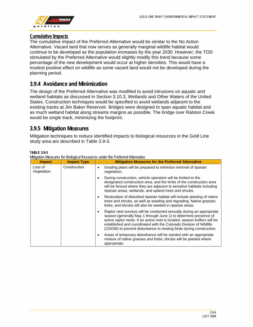
3.9.5 Mitigation Measures Mitigation techniques to reduce identified impacts to biological resources in the Gold Line study area are described in Table 3.9-3.
TABLE 3.9-3 Mitigation Measures for Biological Resources under the Preferred Alternative
Impact Impact Type Mitigation Measures for the Preferred Alternative Loss of Vegetation
Construction • Grading plans will be prepared to minimize removal of riparian vegetation.
• During construction, vehicle operation will be limited to the designated construction area, and the limits of the construction area will be fenced where they are adjacent to sensitive habitats including riparian areas, wetlands, and upland trees and shrubs.
• Restoration of disturbed riparian habitat will include planting of native trees and shrubs, as well as seeding and regrading. Native grasses, forbs, and shrubs will also be seeded in riparian areas.
• Raptor nest surveys will be conducted annually during an appropriate season (generally May 1 through June 1) to determine presence of active raptor nests. If an active nest is located, season buffers will be established and coordinated with the Colorado Division of Wildlife (CDOW) to prevent disturbance to nesting birds during construction.
• Areas of temporary disturbance will be seeded with an appropriate mixture of native grasses and forbs; shrubs will be planted where appropriate.
GOLD LINE DRAFT ENVIRONMENTAL IMPACT STATEMENT
3.9-7 JULY 2008
Impact Impact Type Mitigation Measures for the Preferred Alternative Spread of noxious weeds
Construction • An integrated Noxious Weed Management Plan will be developed. This plan will be implemented during construction and will include identification of noxious weeds in the area, weed management goals and objectives, and preventive and controls methods. Preventive measures include the following: - Contractor vehicles will be inspected before they are used for
construction to ensure that they are free of soil and debris capable of transporting noxious weed seeds or roots.
- Noxious weeds observed in and near the construction area at the start of construction will be treated with herbicides or physically removed to prevent seeds blowing into disturbed areas during construction. Any noxious weeds identified during construction will be identified and treated.
- Potential areas of topsoil salvage will be assessed for presence and abundance of noxious weeds prior to salvage. Topsoil from heavily infested areas will either be treated by spraying, taking offsite, or being buried during construction.
- Areas of temporary disturbance will be reclaimed in phases throughout the project construction and seeded using a permanent native seed mixture. If areas are complete and permanent seeding cannot occur due to the time of year, mulch and mulch tackifier will be used for temporary erosion control until seeding can occur.
- Only certified weed-free mulch and bales will be used in the project.
- Weed control will use the principles of integrated pest management to treat target weed species by using a combination of two or more management techniques (biological, chemical, mechanical, and/or cultural). Weed control methods will be selected based on the management goal for the species, the nature of the existing environment, and methods recommended by Colorado weed experts. The presence of important wildlife habitat or threatened and endangered species will be considered when choosing control methods.
Impacts to aquatic habitats
Construction • BMPs will be used to control erosion and sedimentation during construction and to protect water quality in streams. BMPs may include berms, brush barriers, check dams, erosion control blankets, filter strips, sandbag barriers, sediment basins, sheet mulching, silt fences, straw-bale barriers, surface roughening, and/or diversion channels. A spill prevention and emergency response plan will be prepared and used during construction for storage, handling, and use of chemicals, fuels and similar products, if required. Section 3.10.2, Water Resources.
• See Section 3-10.2, Water Resources. Source: Gold Line Team, 2007