Embed Size (px)
Citation preview
Walk FactsIntroductionRefreshmentsNocton Post OfficeMain Street, NoctonLincoln LN4 2BHTelephone: 01526 320292
The Red LionMiddle Street, DunstonLincoln LN4 2EWTelephone: 01526 322227
AccommodationThe White HorseDunston Fen, DunstonLincoln LN4 3APTelephone: 01526 398341
Shooters Lodge B&BMain Street, NoctonLincoln LN4 2BH
Skelghyll CottageMoor Lane, PotterhanworthLincoln LN4 2DZTelephone: 01522 790043
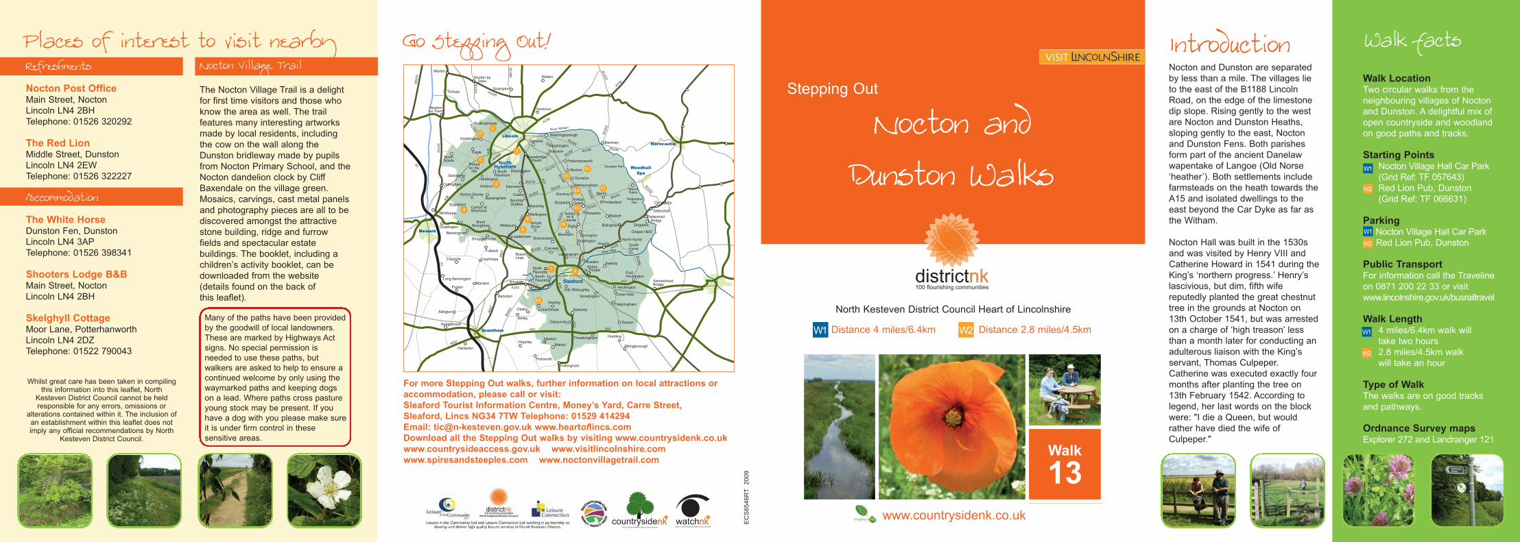
Nocton and Dunston are separatedby less than a mile. The villages lieto the east of the B1188 LincolnRoad, on the edge of the limestonedip slope. Rising gently to the westare Nocton and Dunston Heaths,sloping gently to the east, Noctonand Dunston Fens. Both parishesform part of the ancient Danelawwapentake of Langoe (Old Norse‘heather’). Both settlements includefarmsteads on the heath towards theA15 and isolated dwellings to theeast beyond the Car Dyke as far asthe Witham.
Nocton Hall was built in the 1530sand was visited by Henry VIII andCatherine Howard in 1541 during theKing’s ‘northern progress.’ Henry’slascivious, but dim, fifth wifereputedly planted the great chestnuttree in the grounds at Nocton on13th October 1541, but was arrestedon a charge of ‘high treason’ lessthan a month later for conducting anadulterous liaison with the King’sservant, Thomas Culpeper.Catherine was executed exactly fourmonths after planting the tree on13th February 1542. According tolegend, her last words on the blockwere: "I die a Queen, but wouldrather have died the wife ofCulpeper."
Places of interest to visit nearby
EC
S65
46R
T20
09
For more Stepping Out walks, further information on local attractions oraccommodation, please call or visit:Sleaford Tourist Information Centre, Money’s Yard, Carre Street,Sleaford, Lincs NG34 7TW Telephone: 01529 414294Email: [email protected] www.heartoflincs.comDownload all the Stepping Out walks by visiting www.countrysidenk.co.ukwww.countrysideaccess.gov.uk www.visitlincolnshire.comwww.spiresandsteeples.com www.noctonvillagetrail.com
A1
A11
33
A17
A1500
B1398
A60
7
A607
A15
A15
A52
B1189
B1190
A46
B1188
B1191
A60
7
B1429 A153
B1202
B1241
B12
02
B1190
B1178
B1190
B1202
B1395
B1188
A158
A15
A52
B1191
B11
91
B640
3
B1192
A1434
B1178
A153
B1190
B1202
EastHeckington
Haddington
1
2
3
4
5
67
8
910
11
12
13
14
15
16
17
Go Stepping Out!Stepping Out
Walk
13
North Kesteven District Council Heart of Lincolnshire
www.countrysidenk.co.uk
W1 W2Distance 4 miles/6.4km Distance 2.8 miles/4.5km
Nocton andDunston Walks
Walk LocationTwo circular walks from theneighbouring villages of Noctonand Dunston. A delightful mix ofopen countryside and woodlandon good paths and tracks.
Starting PointsNocton Village Hall Car Park(Grid Ref: TF 057643)Red Lion Pub, Dunston(Grid Ref: TF 066631)
ParkingNocton Village Hall Car ParkRed Lion Pub, Dunston
Public TransportFor information call the Travelineon 0871 200 22 33 or visitwww.lincolnshire.gov.uk/busrailtravel
Walk Length4 miles/6.4km walk willtake two hours2.8 miles/4.5km walkwill take an hour
Type of WalkThe walks are on good tracksand pathways.
Ordnance Survey mapsExplorer 272 and Landranger 121
W1
W2
W1
W2
W1
W2
Whilst great care has been taken in compilingthis information into this leaflet, North
Kesteven District Council cannot be heldresponsible for any errors, omissions or
alterations contained within it. The inclusion ofan establishment within this leaflet does notimply any official recommendations by North
Kesteven District Council.
Many of the paths have been providedby the goodwill of local landowners.These are marked by Highways Actsigns. No special permission isneeded to use these paths, butwalkers are asked to help to ensure acontinued welcome by only using thewaymarked paths and keeping dogson a lead. Where paths cross pastureyoung stock may be present. If youhave a dog with you please make sureit is under firm control in thesesensitive areas.
Nocton Village TrailThe Nocton Village Trail is a delightfor first time visitors and those whoknow the area as well. The trailfeatures many interesting artworksmade by local residents, includingthe cow on the wall along theDunston bridleway made by pupilsfrom Nocton Primary School, and theNocton dandelion clock by CliffBaxendale on the village green.Mosaics, carvings, cast metal panelsand photography pieces are all to bediscovered amongst the attractivestone building, ridge and furrowfields and spectacular estatebuildings. The booklet, including achildren’s activity booklet, can bedownloaded from the website(details found on the back ofthis leaflet).
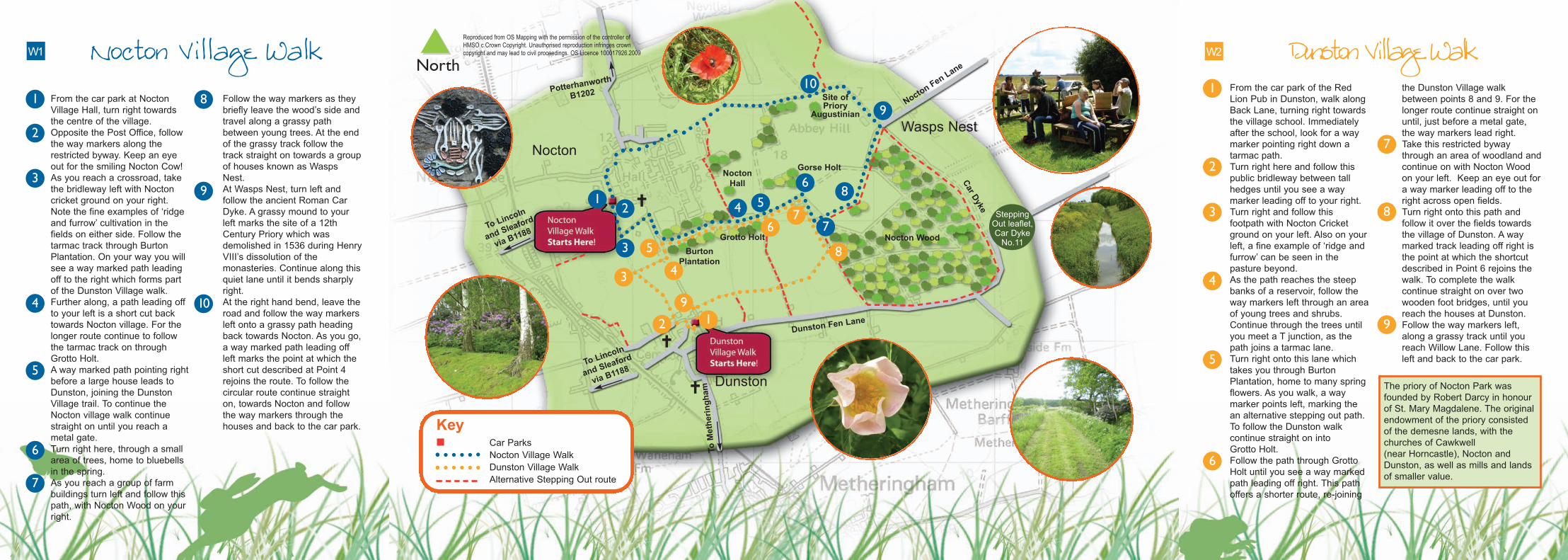
��Nocton Village Walk Dunston Village Walk1. From the car park at Nocton
Village Hall, turn right towardsthe centre of the village.
2. Opposite the Post Office, followthe way markers along therestricted byway. Keep an eyeout for the smiling Nocton Cow!
3. As you reach a crossroad, takethe bridleway left with Noctoncricket ground on your right.Note the fine examples of ‘ridgeand furrow’ cultivation in thefields on either side. Follow thetarmac track through BurtonPlantation. On your way you willsee a way marked path leadingoff to the right which forms partof the Dunston Village walk.
4. Further along, a path leading offto your left is a short cut backtowards Nocton village. For thelonger route continue to followthe tarmac track on throughGrotto Holt.
5. A way marked path pointing rightbefore a large house leads toDunston, joining the DunstonVillage trail. To continue theNocton village walk continuestraight on until you reach ametal gate.
6. Turn right here, through a smallarea of trees, home to bluebellsin the spring.
7. As you reach a group of farmbuildings turn left and follow thispath, with Nocton Wood on yourright.
8. Follow the way markers as theybriefly leave the wood’s side andtravel along a grassy pathbetween young trees. At the endof the grassy track follow thetrack straight on towards a groupof houses known as WaspsNest.
9. At Wasps Nest, turn left andfollow the ancient Roman CarDyke. A grassy mound to yourleft marks the site of a 12thCentury Priory which wasdemolished in 1536 during HenryVIII’s dissolution of themonasteries. Continue along thisquiet lane until it bends sharplyright.
10. At the right hand bend, leave theroad and follow the way markersleft onto a grassy path headingback towards Nocton. As you go,a way marked path leading offleft marks the point at which theshort cut described at Point 4rejoins the route. To follow thecircular route continue straighton, towards Nocton and followthe way markers through thehouses and back to the car park.
Reproduced from OS Mapping with the permission of the controller ofHMSO c Crown Copyright. Unauthorised reproduction infringes crowncopyright and may lead to civil proceedings. OS Licence 100017926.2009
1. From the car park of the RedLion Pub in Dunston, walk alongBack Lane, turning right towardsthe village school. Immediatelyafter the school, look for a waymarker pointing right down atarmac path.
2. Turn right here and follow thispublic bridleway between tallhedges until you see a waymarker leading off to your right.
3. Turn right and follow thisfootpath with Nocton Cricketground on your left. Also on yourleft, a fine example of ‘ridge andfurrow’ can be seen in thepasture beyond.
4. As the path reaches the steepbanks of a reservoir, follow theway markers left through an areaof young trees and shrubs.Continue through the trees untilyou meet a T junction, as thepath joins a tarmac lane.
5. Turn right onto this lane whichtakes you through BurtonPlantation, home to many springflowers. As you walk, a waymarker points left, marking thean alternative stepping out path.To follow the Dunston walkcontinue straight on intoGrotto Holt.
6. Follow the path through GrottoHolt until you see a way markedpath leading off right. This pathoffers a shorter route, re-joining
the Dunston Village walkbetween points 8 and 9. For thelonger route continue straight onuntil, just before a metal gate,the way markers lead right.
7. Take this restricted bywaythrough an area of woodland andcontinue on with Nocton Woodon your left. Keep an eye out fora way marker leading off to theright across open fields.
8. Turn right onto this path andfollow it over the fields towardsthe village of Dunston. A waymarked track leading off right isthe point at which the shortcutdescribed in Point 6 rejoins thewalk. To complete the walkcontinue straight on over twowooden foot bridges, until youreach the houses at Dunston.
9. Follow the way markers left,along a grassy track until youreach Willow Lane. Follow thisleft and back to the car park.
W2W1
KeyCar ParksNocton Village WalkDunston Village WalkAlternative Stepping Out route
To Linco
ln
andSlea
ford
via B1188
Potterhanworth
B1202
ToMetheringham
To Lincoln
and Sleafo
rd
via B1188
Nocton
Dunston
�
�
�
Nocton Wood
Wasps Nest
NoctonHall
Site ofPriory
Augustinian
BurtonPlantation
Grotto Holt
Gorse Holt
Car Dyke
SteppingOut leaflet,Car DykeNo.11
The priory of Nocton Park wasfounded by Robert Darcy in honourof St. Mary Magdalene. The originalendowment of the priory consistedof the demesne lands, with thechurches of Cawkwell(near Horncastle), Nocton andDunston, as well as mills and landsof smaller value.
Nocton FenLan
e
Dunston Fen Lane
11
2
7
8
9
3
4
6
5
2
3 4
5
67
91
8
12
3
4 5
6
7
8
9
10
2
8
9
10
3
4
5
6
7
North