Embed Size (px)
DESCRIPTION
NOAA’s Polar-orbiting Operational Environmental Satellites (POES) Overview. Tom Schott NESDIS/OSD Satellite Product Manager U.S. Department of Commerce - NOAA NOAA Satellite Conference April 8-12, 2013. Topics. Polar-orbiting Operational Environmental Satellite (POES) - PowerPoint PPT Presentation
Citation preview
NOAA’s Polar-orbiting Operational Environmental Satellites (POES) Overview
Tom SchottNESDIS/OSD Satellite Product ManagerU.S. Department of Commerce - NOAA
NOAA Satellite ConferenceApril 8-12, 2013
1
Topics• Polar-orbiting Operational Environmental
Satellite (POES)• Initial Joint Polar-orbiting System (IJPS)
2
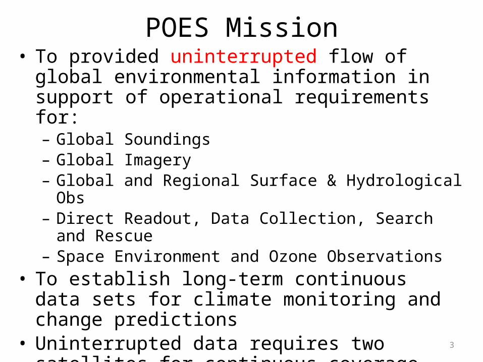
POES Mission• To provided uninterrupted flow of global environmental
information in support of operational requirements for:– Global Soundings – Global Imagery– Global and Regional Surface & Hydrological Obs– Direct Readout, Data Collection, Search and Rescue– Space Environment and Ozone Observations
• To establish long-term continuous data sets for climate monitoring and change predictions
• Uninterrupted data requires two satellites for continuous coverage placed in orbits selected to optimize support for both weather services and climate requirements.
3
4
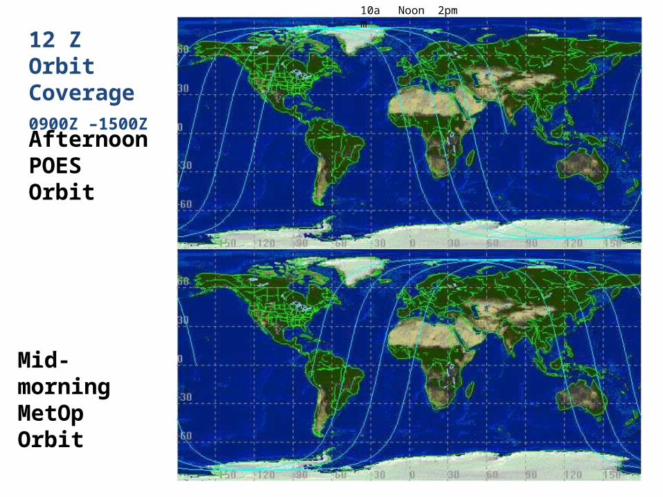
12 Z Orbit Coverage0900Z –1500Z
Afternoon POES Orbit
Mid-morning MetOp Orbit
10am Noon 2pm
5
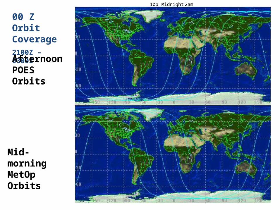
00 Z Orbit Coverage2100Z – 0300Z
Afternoon POES Orbits
Mid-morning MetOp Orbits
10pm Midnight 2am
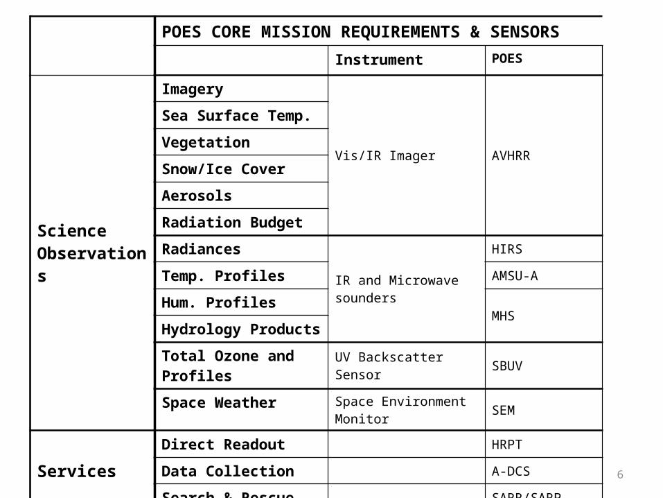
POES CORE MISSION REQUIREMENTS & SENSORSInstrument POES
Science Observations
Imagery
Vis/IR Imager AVHRR
Sea Surface Temp.
Vegetation
Snow/Ice Cover
Aerosols
Radiation Budget
Radiances
IR and Microwave sounders
HIRS
Temp. Profiles AMSU-A
Hum. ProfilesMHS
Hydrology Products
Total Ozone and Profiles UV Backscatter Sensor SBUV
Space Weather Space Environment Monitor SEM
ServicesDirect Readout HRPT
Data Collection A-DCS
Search & Rescue SARR/SARP
6
Major Customers• Numerical Weather Prediction Centers• NWS National Centers for Environmental Prediction • National Weather Service Field Offices• NOAA Ocean Service and NOAA Marine Fisheries• Hazard community (Volcanic Ash Centers, US Forest Service)• Other U.S. Federal Agencies• International community • Global climate community• Direct Readout Users
– High-resolution Picture Transmission (HRPT) Users– Automatic Picture Transmission (APT) Users– Search and Rescue– Data Collection System
7
International Partners• European Organization for the Exploitation of
Meteorological Satellites (EUMETSAT)– MetOp Satellites
• Canada – Department of National Defense (DND)– Search and Rescue Repeater (SARR)
• France – Center National d’Etudes Spatiales (CNES)– Search and Rescue Processor (SARP)– Data Collection (DCS & A-DCS)
8
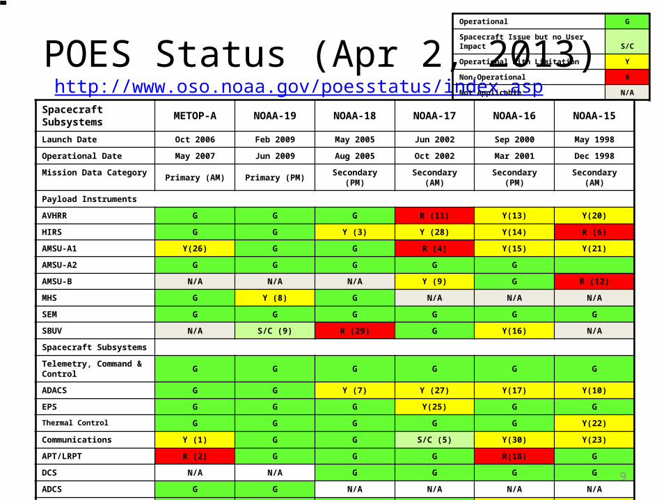
POES Status (Apr 2, 2013) http://www.oso.noaa.gov/poesstatus/index.asp
Operational G
Spacecraft Issue but no User Impact S/C
Operational with Limitation Y
Non-Operational R
Not Applicable N/A
Spacecraft Subsystems METOP-A NOAA-19 NOAA-18 NOAA-17 NOAA-16 NOAA-15Launch Date Oct 2006 Feb 2009 May 2005 Jun 2002 Sep 2000 May 1998
Operational Date May 2007 Jun 2009 Aug 2005 Oct 2002 Mar 2001 Dec 1998
Mission Data Category Primary (AM) Primary (PM) Secondary (PM) Secondary (AM) Secondary (PM) Secondary (AM)
Payload Instruments
AVHRR G G G R (11) Y(13) Y(20)
HIRS G G Y (3) Y (28) Y(14) R (6)
AMSU-A1 Y(26) G G R (4) Y(15) Y(21)
AMSU-A2 G G G G G
AMSU-B N/A N/A N/A Y (9) G R (12)
MHS G Y (8) G N/A N/A N/A
SEM G G G G G G
SBUV N/A S/C (9) R (29) G Y(16) N/A
Spacecraft Subsystems
Telemetry, Command & Control G G G G G G
ADACS G G Y (7) Y (27) Y(17) Y(10)
EPS G G G Y(25) G G
Thermal Control G G G G G Y(22)
Communications Y (1) G G S/C (5) Y(30) Y(23)
APT/LRPT R (2) G G G R(18) G
DCS N/A N/A G G G G
ADCS G G N/A N/A N/A N/A
SAR G G G G Y(19) Y(24)
9
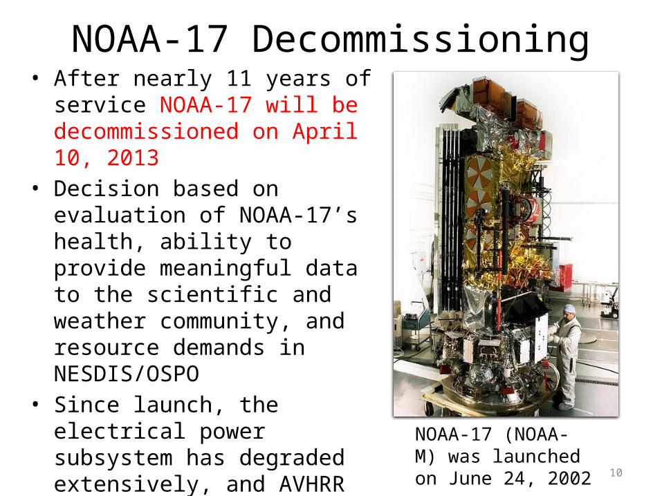
NOAA-17 Decommissioning• After nearly 11 years of
service NOAA-17 will be decommissioned on April 10, 2013
• Decision based on evaluation of NOAA-17’s health, ability to provide meaningful data to the scientific and weather community, and resource demands in NESDIS/OSPO
• Since launch, the electrical power subsystem has degraded extensively, and AVHRR and AMSU-A1 instruments are no longer functional
• Metop-A and B will replace NOAA-17’s data coverage
10
NOAA-17 (NOAA-M) was launched on June 24, 2002
Initial Joint Polar-orbiting System (IJPS)
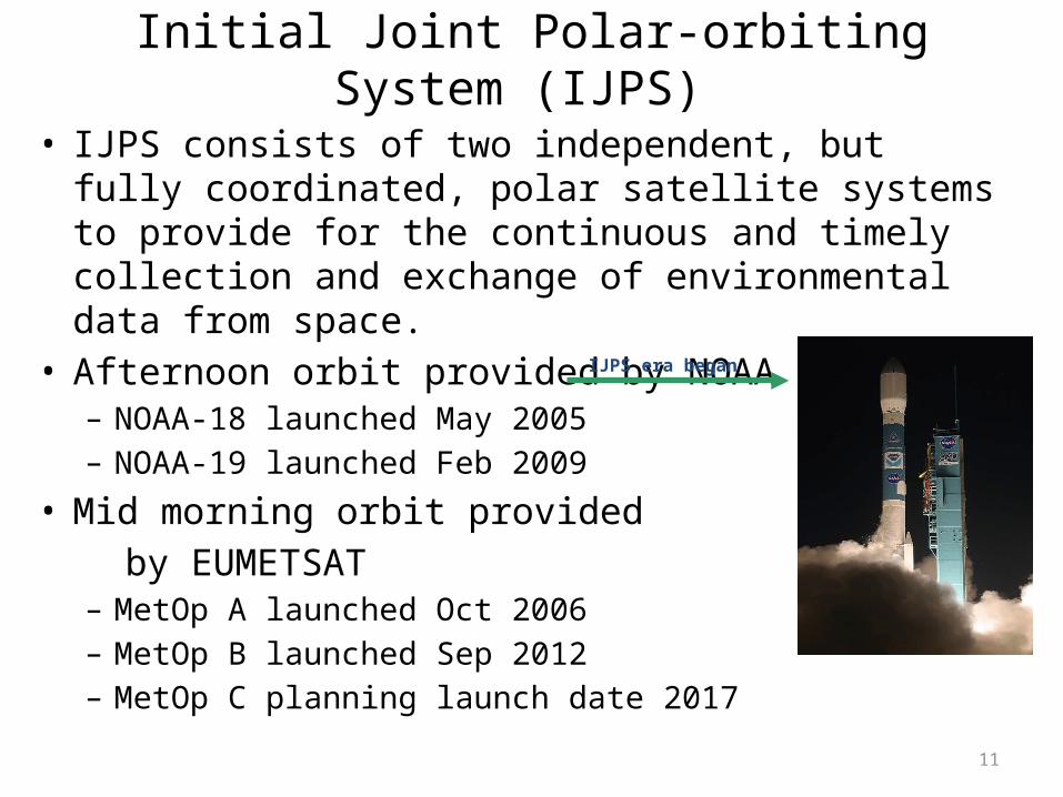
• IJPS consists of two independent, but fully coordinated, polar satellite systems to provide for the continuous and timely collection and exchange of environmental data from space.
• Afternoon orbit provided by NOAA – NOAA-18 launched May 2005– NOAA-19 launched Feb 2009
• Mid morning orbit provided by EUMETSAT– MetOp A launched Oct 2006– MetOp B launched Sep 2012– MetOp C planning launch date 2017
11
IJPS era began
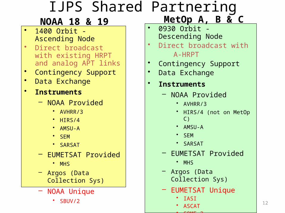
IJPS Shared Partnering
12
• 1400 Orbit -Ascending Node• Direct broadcast with existing
HRPT and analog APT links• Contingency Support• Data Exchange• Instruments
– NOAA Provided• AVHRR/3• HIRS/4• AMSU-A• SEM• SARSAT
– EUMETSAT Provided• MHS
– Argos (Data Collection Sys)– NOAA Unique
• SBUV/2
• 0930 Orbit - Descending Node• Direct broadcast with A-HRPT• Contingency Support• Data Exchange• Instruments
– NOAA Provided• AVHRR/3• HIRS/4 (not on MetOp C)• AMSU-A• SEM• SARSAT
– EUMETSAT Provided• MHS
– Argos (Data Collection Sys)– EUMETSAT Unique
• IASI• ASCAT• GOME-2• GRAS
NOAA 18 & 19 MetOp A, B & C
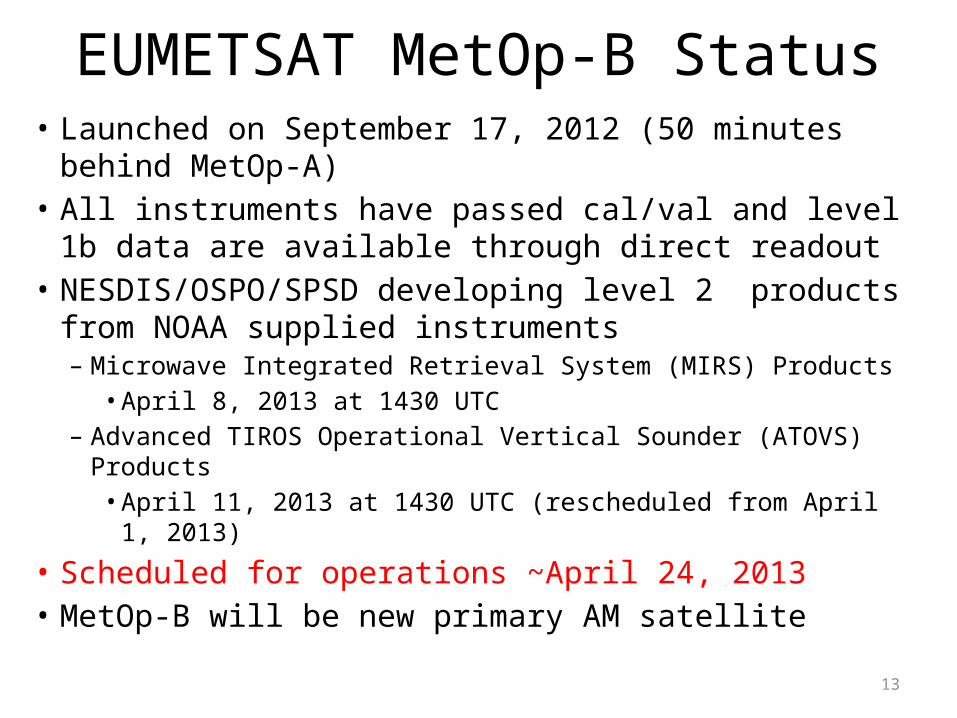
EUMETSAT MetOp-B Status• Launched on September 17, 2012 (50 minutes behind
MetOp-A) • All instruments have passed cal/val and level 1b data are
available through direct readout• NESDIS/OSPO/SPSD developing level 2 products from
NOAA supplied instruments– Microwave Integrated Retrieval System (MIRS) Products
• April 8, 2013 at 1430 UTC – Advanced TIROS Operational Vertical Sounder (ATOVS) Products
• April 11, 2013 at 1430 UTC (rescheduled from April 1, 2013)
• Scheduled for operations ~April 24, 2013• MetOp-B will be new primary AM satellite
13
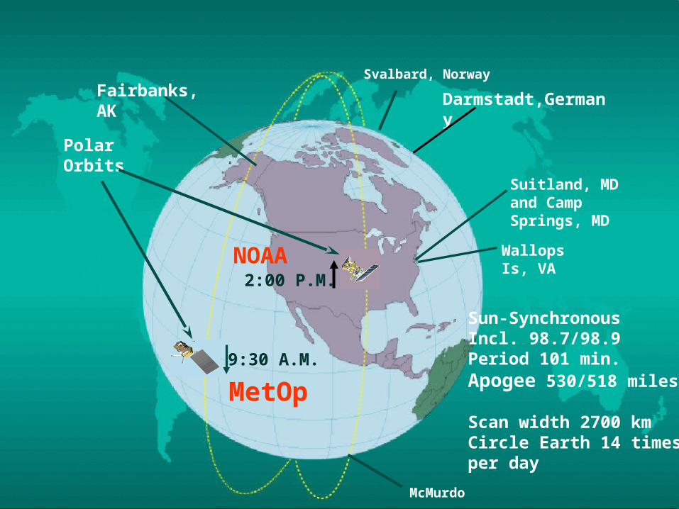
Initial Joint Polar-orbiting System (IJPS)
14
Svalbard, Norway
Suitland, MD and Camp Springs, MD
Wallops Is, VA
9:30 A.M.
PolarOrbits
Fairbanks, AK
2:00 P.M.
Sun-SynchronousIncl. 98.7/98.9Period 101 min.Apogee 530/518 miles
Scan width 2700 kmCircle Earth 14 timesper day
Darmstadt,Germany
MetOp
NOAA
McMurdo
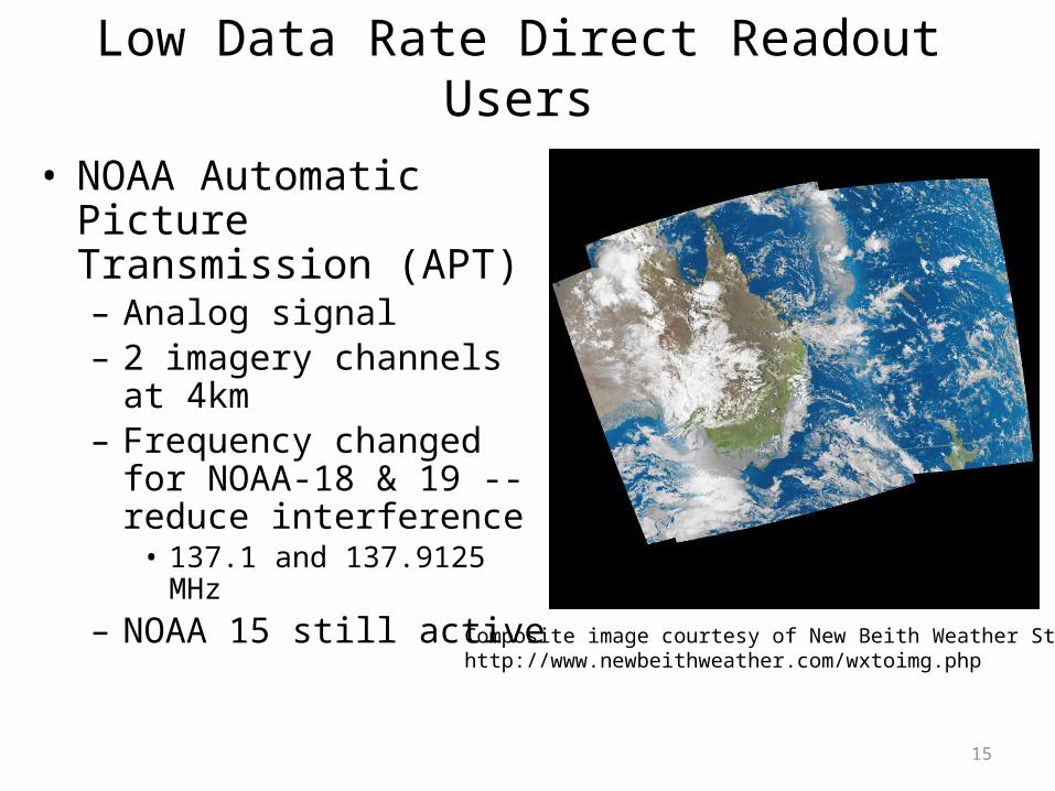
Low Data Rate Direct Readout Users
• NOAA Automatic Picture Transmission (APT)– Analog signal– 2 imagery channels at 4km– Frequency changed for
NOAA-18 & 19 -- reduce interference• 137.1 and 137.9125 MHz
– NOAA 15 still active
15
Composite image courtesy of New Beith Weather Stationhttp://www.newbeithweather.com/wxtoimg.php
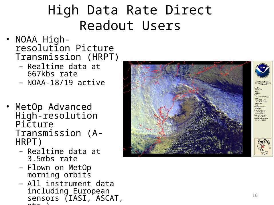
High Data Rate Direct Readout Users• NOAA High-resolution
Picture Transmission (HRPT)– Realtime data at 667kbs rate– NOAA-18/19 active
• MetOp Advanced High-resolution Picture Transmission (A-HRPT)– Realtime data at 3.5mbs rate– Flown on MetOp morning
orbits – All instrument data including
European sensors (IASI, ASCAT, etc.)
– Can be encrypted
16
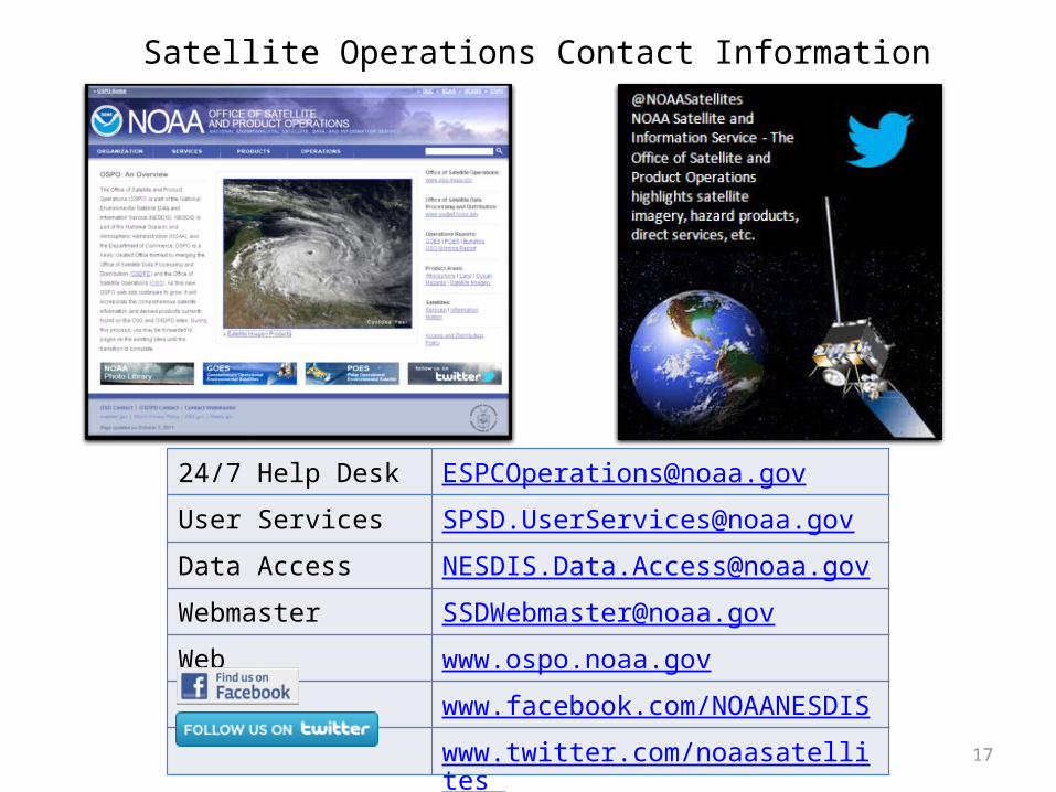
24/7 Help Desk [email protected]
User Services [email protected]
Data Access [email protected]
Webmaster [email protected]
Web www.ospo.noaa.gov
www.facebook.com/NOAANESDIS
www.twitter.com/noaasatellites
Satellite Operations Contact Information
17
Summary• NOAA continues to partner with EUMETSAT in
the mid-morning polar orbit• NOAA-19 is the last of the POES satellites for the
afternoon polar orbit– POES satellites have served the nation since the early
1960s• Joint Polar Satellite System (JPSS) ensures
afternoon polar orbit capabilities continue
18