Embed Size (px)
Citation preview
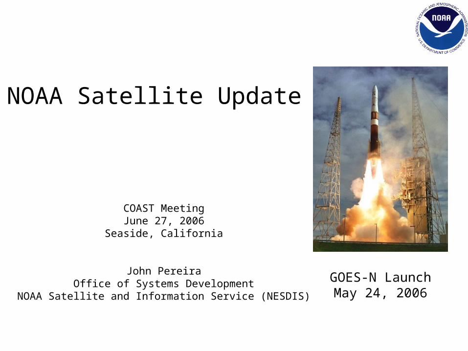
NOAA Satellite Update
COAST MeetingJune 27, 2006
Seaside, California
John PereiraOffice of Systems Development
NOAA Satellite and Information Service (NESDIS)
GOES-N LaunchMay 24, 2006
Topics
• NPOESS
• POES
• GOES 9 - 12
• GOES-N/13
• GOES-R
• NSOF
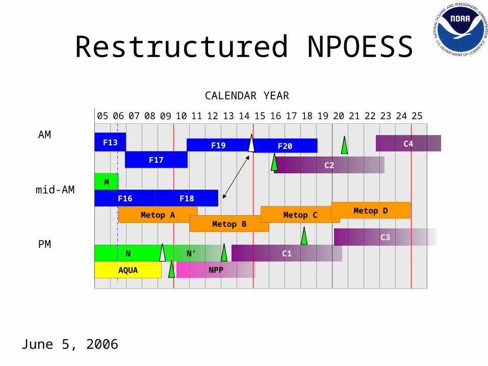
Restructured NPOESS
F17
F19
F18
F20
F16
F13
M
N N’
NPP
Metop AMetop B
Metop C
C1
C2
C3
AM
mid-AM
PM
05 06 07 08 09 11 12 13 14 15 16 17 18 19 20 21 22 23 24 2510
AQUA
Metop D
C4
CALENDAR YEAR
June 5, 2006
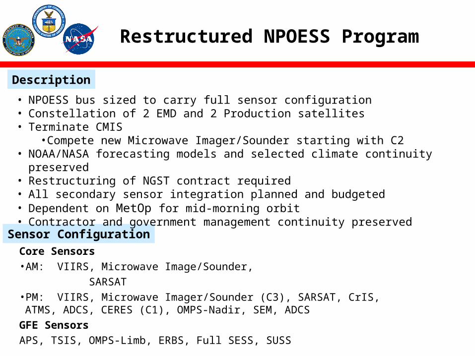
Restructured NPOESS Program
Description
Sensor Configuration
• NPOESS bus sized to carry full sensor configuration• Constellation of 2 EMD and 2 Production satellites• Terminate CMIS
•Compete new Microwave Imager/Sounder starting with C2• NOAA/NASA forecasting models and selected climate continuity preserved• Restructuring of NGST contract required• All secondary sensor integration planned and budgeted• Dependent on MetOp for mid-morning orbit• Contractor and government management continuity preserved
Core Sensors• AM: VIIRS, Microwave Image/Sounder,
SARSAT• PM: VIIRS, Microwave Imager/Sounder (C3), SARSAT, CrIS, ATMS, ADCS,
CERES (C1), OMPS-Nadir, SEM, ADCS
GFE Sensors
APS, TSIS, OMPS-Limb, ERBS, Full SESS, SUSS
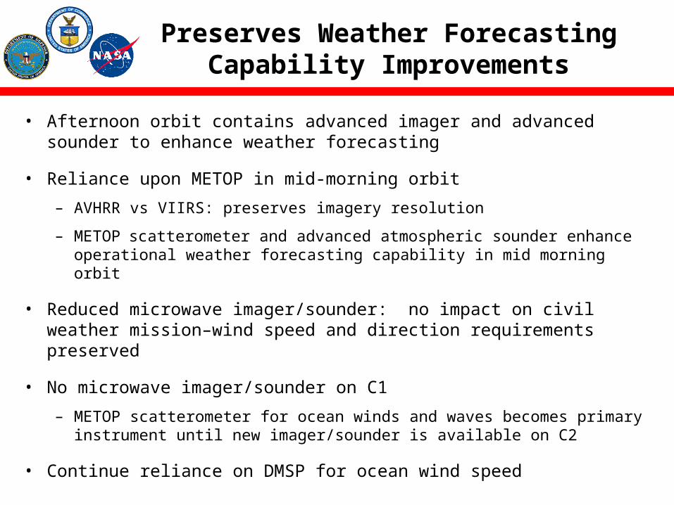
Preserves Weather Forecasting Capability Improvements
• Afternoon orbit contains advanced imager and advanced sounder to enhance weather forecasting
• Reliance upon METOP in mid-morning orbit
– AVHRR vs VIIRS: preserves imagery resolution
– METOP scatterometer and advanced atmospheric sounder enhance operational weather forecasting capability in mid morning orbit
• Reduced microwave imager/sounder: no impact on civil weather mission–wind speed and direction requirements preserved
• No microwave imager/sounder on C1
– METOP scatterometer for ocean winds and waves becomes primary instrument until new imager/sounder is available on C2
• Continue reliance on DMSP for ocean wind speed
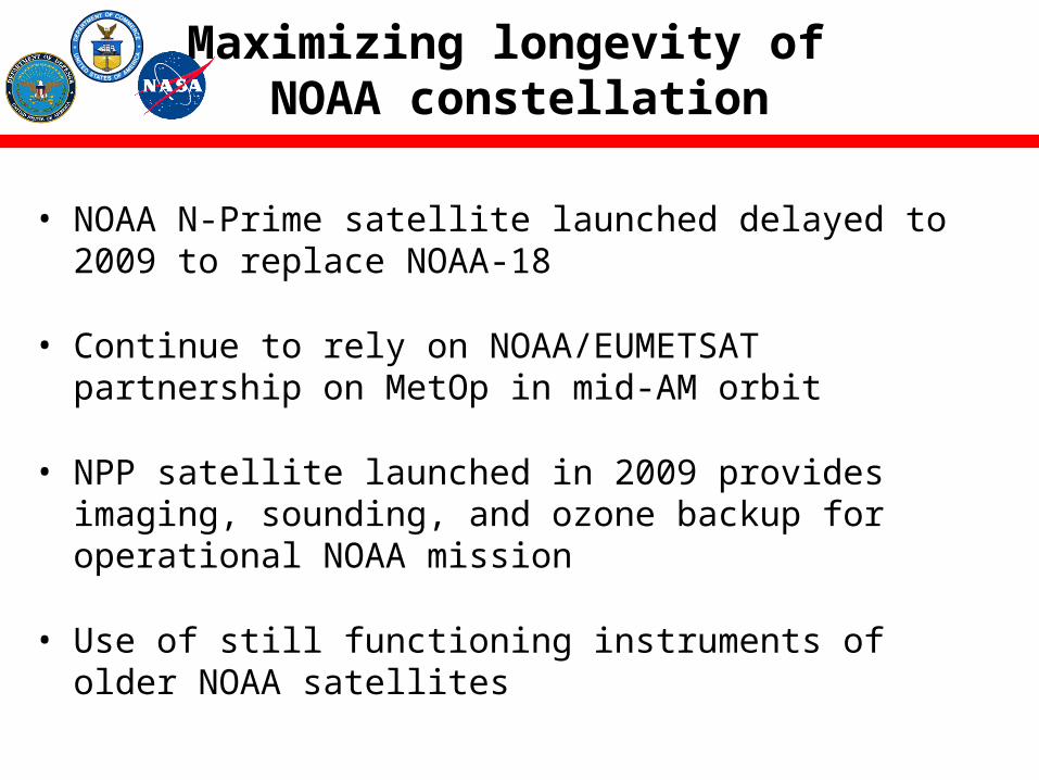
Maximizing longevity of NOAA constellation
• NOAA N-Prime satellite launched delayed to 2009 to replace NOAA-18
• Continue to rely on NOAA/EUMETSAT partnership on MetOp in mid-AM orbit
• NPP satellite launched in 2009 provides imaging, sounding, and ozone backup for operational NOAA mission
• Use of still functioning instruments of older NOAA satellites
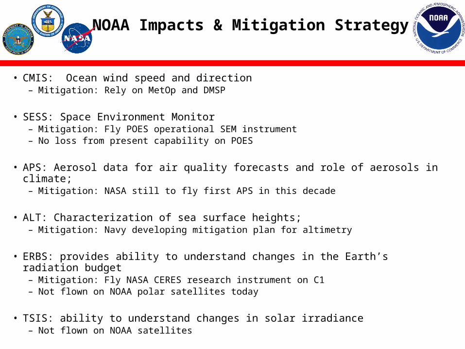
NOAA Impacts & Mitigation Strategy
• CMIS: Ocean wind speed and direction– Mitigation: Rely on MetOp and DMSP
• SESS: Space Environment Monitor – Mitigation: Fly POES operational SEM instrument – No loss from present capability on POES
• APS: Aerosol data for air quality forecasts and role of aerosols in climate; – Mitigation: NASA still to fly first APS in this decade
• ALT: Characterization of sea surface heights; – Mitigation: Navy developing mitigation plan for altimetry
• ERBS: provides ability to understand changes in the Earth’s radiation budget – Mitigation: Fly NASA CERES research instrument on C1 – Not flown on NOAA polar satellites today
• TSIS: ability to understand changes in solar irradiance– Not flown on NOAA satellites
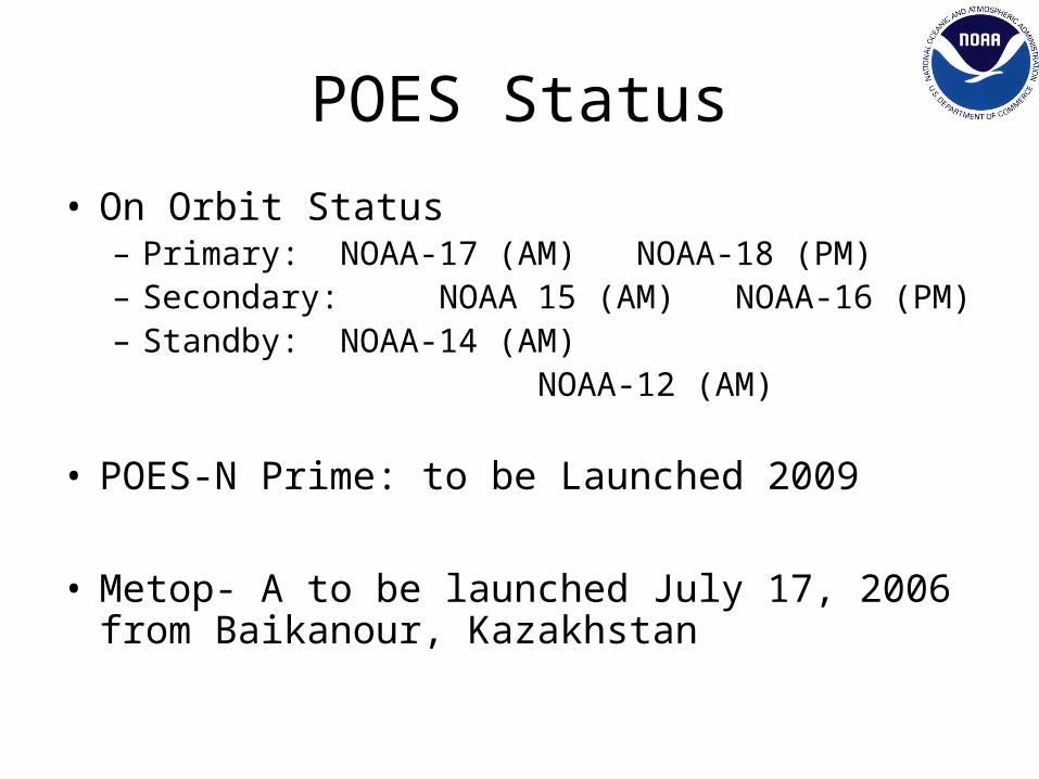
POES Status
• On Orbit Status– Primary: NOAA-17 (AM) NOAA-18 (PM)– Secondary: NOAA 15 (AM) NOAA-16 (PM)– Standby: NOAA-14 (AM) NOAA-12 (AM)
• POES-N Prime: to be Launched 2009
• Metop- A to be launched July 17, 2006 from Baikanour, Kazakhstan
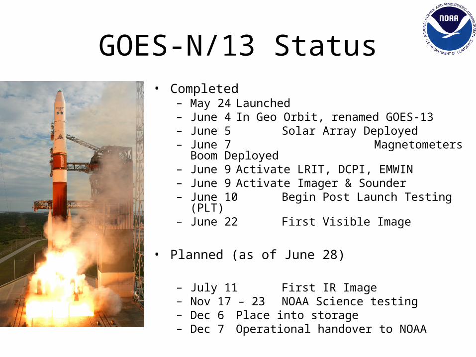
GOES-N/13 Status• Completed
– May 24 Launched– June 4 In Geo Orbit, renamed GOES-13– June 5 Solar Array Deployed – June 7 Magnetometers Boom Deployed– June 9 Activate LRIT, DCPI, EMWIN– June 9 Activate Imager & Sounder– June 10 Begin Post Launch Testing (PLT)– June 22 First Visible Image
• Planned (as of June 28)
– July 11 First IR Image– Nov 17 – 23 NOAA Science testing– Dec 6 Place into storage– Dec 7 Operational handover to NOAA
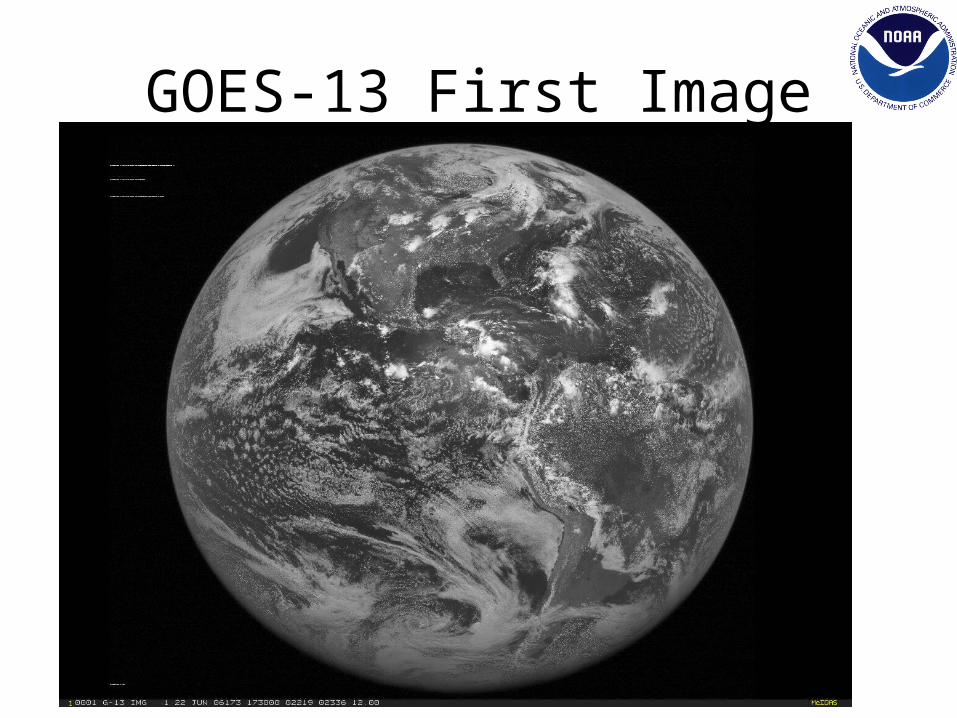
GOES-13 First Image
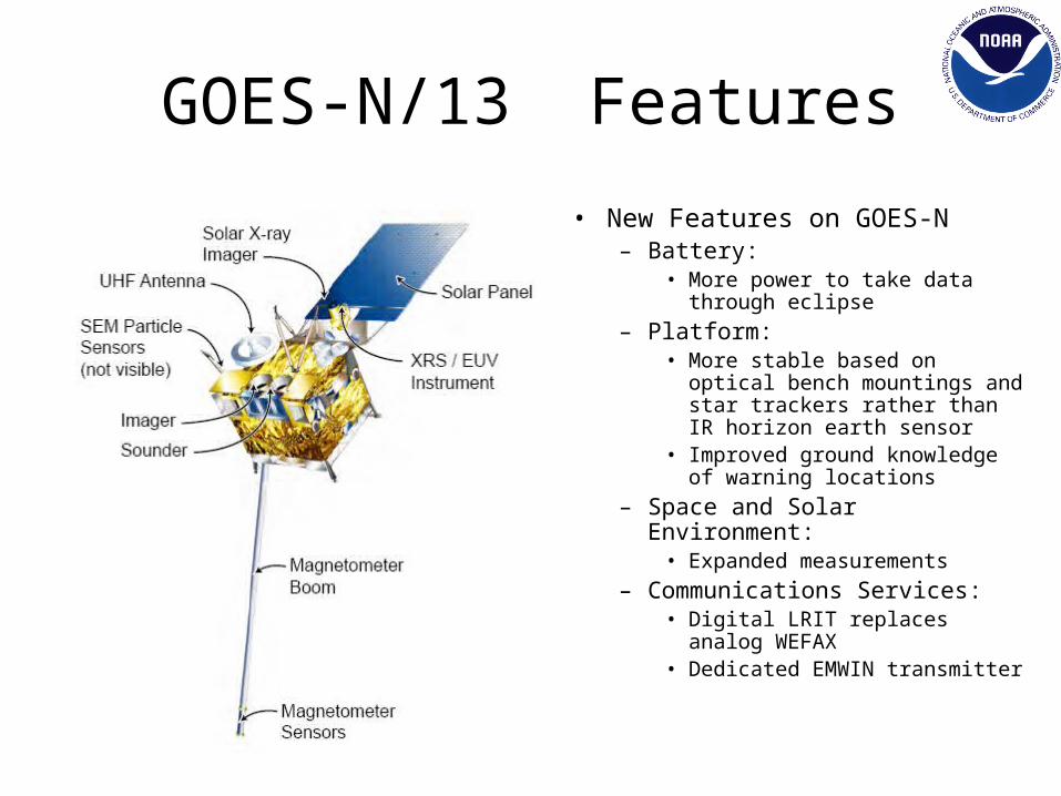
GOES-N/13 Features
• New Features on GOES-N– Battery:
• More power to take data through eclipse
– Platform:• More stable based on optical
bench mountings and star trackers rather than IR horizon earth sensor
• Improved ground knowledge of warning locations
– Space and Solar Environment:• Expanded measurements
– Communications Services:• Digital LRIT replaces analog
WEFAX• Dedicated EMWIN transmitter
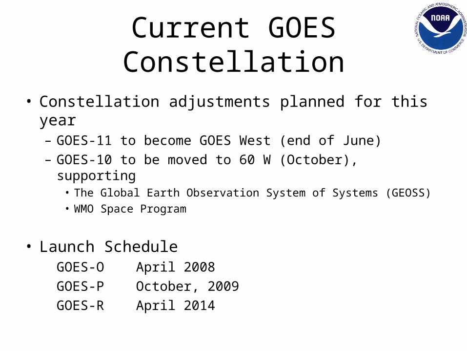
Current GOES Constellation
• Constellation adjustments planned for this year– GOES-11 to become GOES West (end of June)– GOES-10 to be moved to 60 W (October), supporting
• The Global Earth Observation System of Systems (GEOSS)• WMO Space Program
• Launch ScheduleGOES-O April 2008
GOES-P October, 2009
GOES-R April 2014
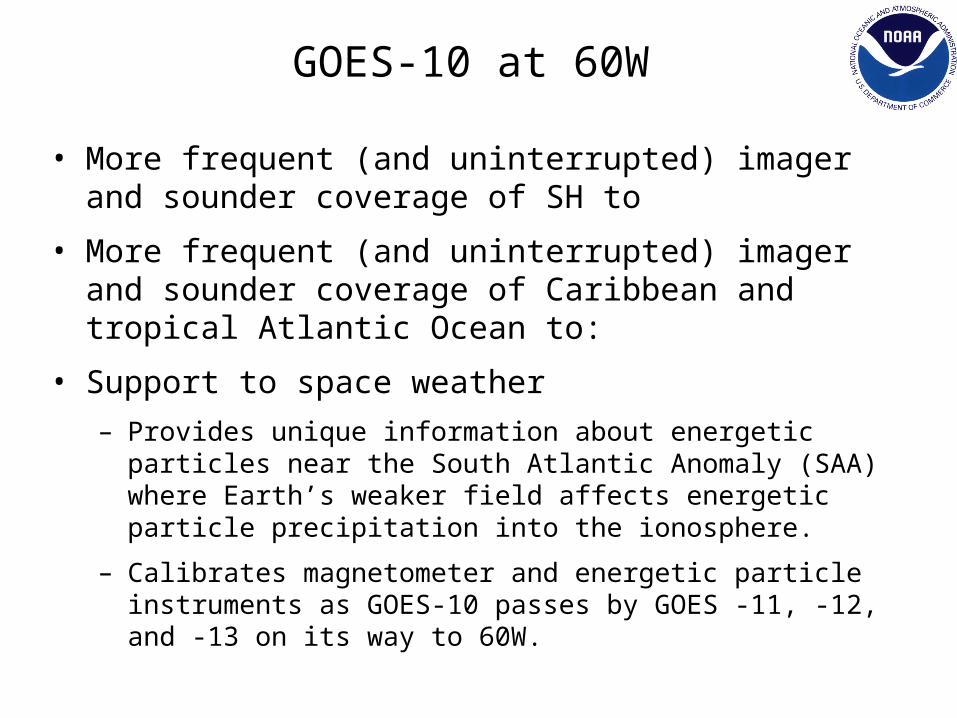
GOES-10 at 60W
• More frequent (and uninterrupted) imager and sounder coverage of SH to
• More frequent (and uninterrupted) imager and sounder coverage of Caribbean and tropical Atlantic Ocean to:
• Support to space weather
– Provides unique information about energetic particles near the South Atlantic Anomaly (SAA) where Earth’s weaker field affects energetic particle precipitation into the ionosphere.
– Calibrates magnetometer and energetic particle instruments as GOES-10 passes by GOES -11, -12, and -13 on its way to 60W.
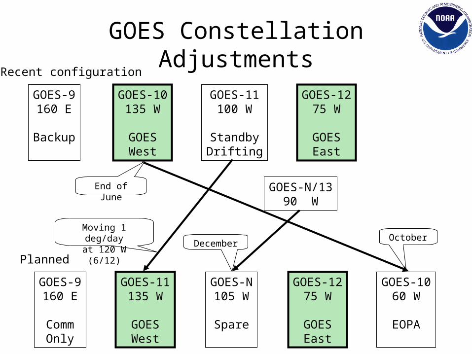
GOES Constellation AdjustmentsRecent configuration
Planned
GOES-9160 E
Backup
GOES-10135 W
GOESWest
GOES-11100 W
StandbyDrifting
GOES-1275 W
GOESEast
GOES-N/1390 W
GOES-9160 E
CommOnly
GOES-1060 W
EOPA
GOES-11135 W
GOESWest
GOES-1275 W
GOESEast
GOES-N105 W
Spare
December
Moving 1 deg/dayat 120 W (6/12) October
End of June
GOES-R Status
• NOAA-led team formed at NASA’s Goddard Space Flight Center
• Program in Program Definition and Risk Reduction (PDRR) Phase, with three vendors competing to become the system prime contractor – October 2005: PDRR contracts ($10M each) awarded to
Boeing, Lockheed Martin and Northrop Grumman– Contractors completing numerous studies to develop
system design and architecture
• Long lead time instrument procurements underway
HES Status
• NASA awarded three 2-year, $20-million Risk reduction contracts in June 2004– BAE, Ball, and ITT
• Each company studied the minimum HES operational performance (threshold) tasks, as well as goal performance requirements and tasks
• NOAA and NASA are currently reviewing contractor studies
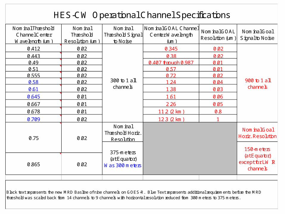
Nominal Threshold Channel Center Wavelength (um)
Nominal Threshold
Resolution (um)
Nominal Threshold Signal
to Noise
Nominal GOAL Channel Center Wavelength
(um)
Nominal GOAL Resolution (um)
Nominal Goal Signal to Noise
0.412 0.02 0.345 0.02
0.443 0.02 0.38 0.020.49 0.02 0.407 through 0.987 0.010.51 0.02 0.57 0.010.555 0.02 0.72 0.020.58 0.02 1.24 0.040.61 0.02 1.38 0.03
0.645 0.01 1.61 0.06
0.667 0.01 2.26 0.05
0.678 0.01 11.2 (2 km) 0.8
0.709 0.02 12.3 (2 km) 1Nominal
Threshold Horiz. Resolution
Nominal Goal Horiz. Resolution
0.865 0.02
0.75
Black text represents the new MRD Basline of nine channels on GOES-R. Blue Text represents additional requirements before the MRD threshold was scaled back from 14 channels to 9 channels with horizontal resolution reduced from 300 meters to 375 meters.
HES-CW Operational Channel Specifications
375-meters (at Equator)
Was 300 meters
150-meters (at Equator)
except for LW IR channels
300 to 1 all channels
900 to 1 all channels
0.02
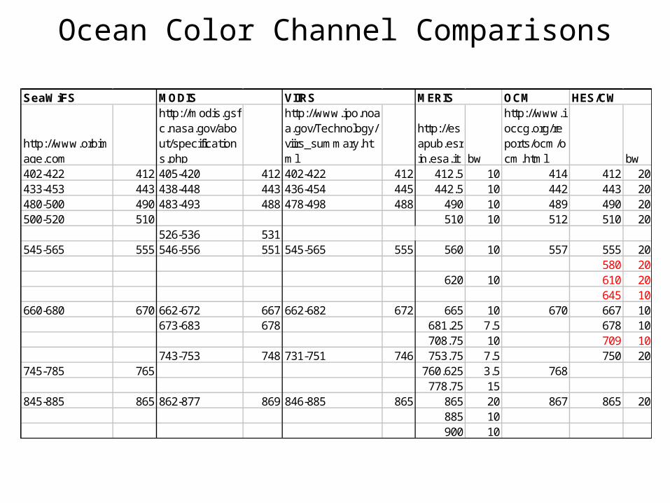
Ocean Color Channel Comparisons
OCM
http://www.orbimage.com
http://modis.gsfc.nasa.gov/about/specifications.php
http://www.ipo.noaa.gov/Technology/viirs_summary.html
http://esapub.esrin.esa.it bw
http://www.ioccg.org/reports/ocm/ocm.html bw
402-422 412 405-420 412 402-422 412 412.5 10 414 412 20433-453 443 438-448 443 436-454 445 442.5 10 442 443 20480-500 490 483-493 488 478-498 488 490 10 489 490 20500-520 510 510 10 512 510 20
526-536 531545-565 555 546-556 551 545-565 555 560 10 557 555 20
580 20620 10 610 20
645 10660-680 670 662-672 667 662-682 672 665 10 670 667 10
673-683 678 681.25 7.5 678 10708.75 10 709 10
743-753 748 731-751 746 753.75 7.5 750 20745-785 765 760.625 3.5 768
778.75 15845-885 865 862-877 869 846-885 865 865 20 867 865 20
885 10900 10
SeaWiFS MODIS VIIRS HES/CWMERIS
GOES-R Instruments
• Advanced Baseline Imager (ABI) – Monitors and tracks severe weather– Images clouds to support forecasts– Better resolution, faster coverage and more coverage simultaneously
• Hyperspectral Environmental Suite (HES)– Provides atmospheric moisture and temperature profiles to support forecasts and climate monitoring– Monitors coastal regions for ecosystem health, water quality, coastal erosion, harmful algal blooms– Better resolution, faster coverage, adds coastal water imagery
• Solar Imaging Suite (SIS) and Space Environmental In-Situ Suite (SEISS)– Images the sun and measures solar output to monitor solar storms (SIS)
• Better Imager (UV over X-Ray)
– Measures magnetic fields and charged particles (SEISS)• Better Heavy Ion detection, adds low energy electrons and protons
– Enables early warnings for satellite and power grid operations, telecom services, astronauts, and airlines
• Geostationary Lightning Mapper (GLM)– Detects lightning strikes as an indicator of severe storms– Previous capability only existed on polar satellites
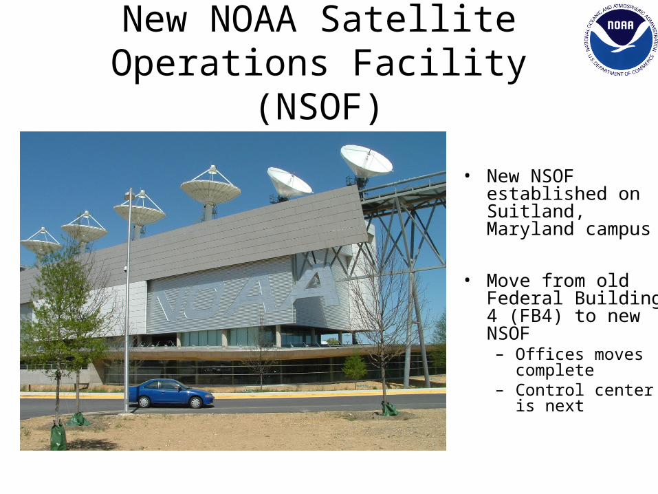
New NOAA Satellite Operations Facility (NSOF)
• New NSOF established on Suitland, Maryland campus
• Move from old Federal Building 4 (FB4) to new NSOF– Offices moves
complete– Control center is
next