Embed Size (px)
Citation preview

NTHMP Grant Semi-Annual Progress Report NOAA Grant Award Number: NA15NWS4670029 Period of performance (start date to end date of entire grant): September 1, 2015 – August 31, 2017 Award reporting period (date range): Sept. 1, 2015 – February 28, 2016 Primary award recipient (name, address, telephone, email): James T. Kirby Center for Applied Coastal Research University of Delaware Newark, DE 19716 USA 1-302-831-2438, [email protected] Subaward recipient(s): (name, address, telephone, email): Stephan Grilli Department of Ocean Engineering University of Rhode Island Narragansett, RI 02882 USA 1-401-874-6636, [email protected] Person submitting report: James T. Kirby Date of this report: May 5, 2016 Instructions: add rows to the table below as needed to complete reporting on all tasks awarded. Fill in all cells within the table. Make sure that task titles match the current Project Narrative for this grant. Task #
Task title Progress made during this reporting period
Challenges and successes % of total task completed
1 Tsunamigenic Landslide Modeling Benchmark Development, Validation Workshop and Workshop Documentation
Galveston, TX has been chosen as site of workshop, which will be help in December 2016 or January 2017, depending on facility and
Benchmark test cases are being developed in collaboration with collaborators at a number of national and international institutions
10%

participant availability. Potential benchmarks tests are being collected. These include analytical cases, laboratory measurements, and real event hindcasts.
2 Refinement and extension of potential SMF sources and source modeling techniques for tsunami activity in the North Atlantic
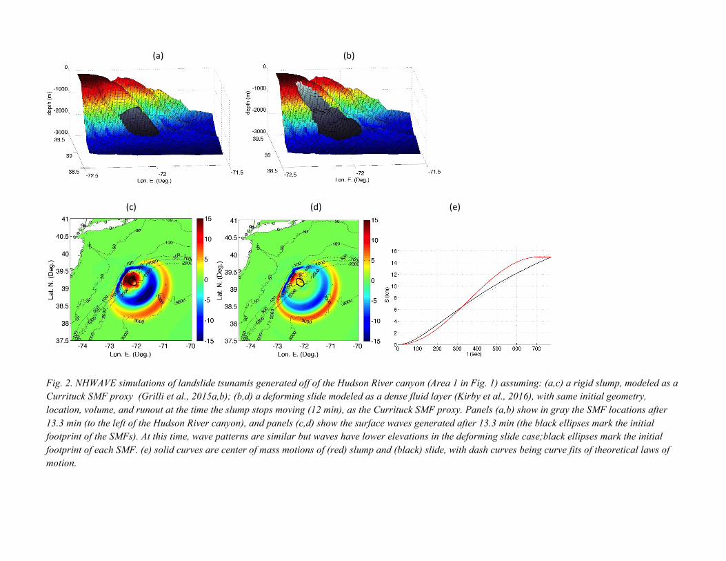
Work on West Bahama Banks potential landslides submitted for publication SMF tsunami sources used and parameterized s Currituck slide proxies north of the Carolinas are being revisited and modeled as deforming slides, rather than rigid slumps. The latter, while not being entirely realistic also led to overestimating tsunami generations. The Hudson River Canyon SMF and the Currituck slide have so far been remodeled assuming they behave as a dense fluid layer. As expected, tsunami generation is reduced (see, e.g., Figs. 1,2) Model parameters for the deforming slides are being selected based on simulating laboratory experiments and field case studies (e.g., Figs., 3,4).
Journal paper under review. Methodology for computing deformable landslides being used to refine East Coast source descriptions. NGDC tsunami DEM’s are now available for the southern portion of Florida, and delayed inundation mapping will be completed during the remainder of this project. Work on deformable slide modeling is strongly synergistic with work of Grilli and Kirby supported by NSF Engineering for Natural Hazards program, which covers ongoing model development and improvement, with technology immediately transferred to NTHMP project.
25%
3 Tsunami Hazard Assessment for Un-modeled East Coast Sites
Storm surge maps for US East Coast stated being collected from constituents. Analysis of correspondence between storm surge inundation lines and tsunami inundation lines for mapped areas underway.
A journal article has been prepared for submission but is still getting last minute revisions. Work on comparison of tsunami and storm surge inundation lines needs to be further coordinated with Gulf
25%

Work on effect of shelf geometry in controlling location of high tsunami hazard is being completed.
Coast effort.
During this reporting period, was any budget reprogramming required for this award? If so…
a. Date reprogramming approved by NWS Tsunami Program Office: b. Date approved by NOAA Grants Office:
c. Describe where funds were moved and why:
General comments from recipient about progress during this reporting period:
PROBLEMS ENCOUNTERED: Development of DEM’s for southern Florida delayed until recently. These are now available and draft map products will be completed during summer 2016.
ANTICIPATED OUTCOMES: Results for the additional mapping efforts described here will be presented in the form of technical reports for each NGDC DEM or similarly sized coastal region, and in the form of draft inundation maps for coastal communities within the DEM regions. Project results are displayed at the project website http://www.udel.edu/kirby/nthmp.html and will be displayed at the NTHMP website http://ws.weather.gov/nthmp/index.html as they are finalized. Draft maps and reports are presently available at an unlinked site http://www.udel.edu/kirby/nthmp_protect.html prior to their review by local state agencies.
Refinement of modeling techniques for simulating landslide (SMF) tsunami generation will lead to published papers and enhancements to the public domain model NHWAVE, and will play a central role in the landslide tsunami benchmark workshop in 2016/2017. An overview of ongoing work, in the context of refining sources for East Coast tsunami events, may be found at the end of this document.
PUBLICATIONS AND PRESENTATIONS REFERENCING FY14-15 WORK
Grilli, S.T., Grilli, A.R., Tehranirad, B. and J.T. Kirby 2015a, “Modeling tsunami sources and their propagation in the Atlantic Ocean for coastal tsunami hazard assessment and inundation mapping along the US East Coast”. In Proc. 2015 COPRI Solutions to Coastal Disasters Conf. (Boston, USA. September 9-11, 2015), ASCE, 12 pps., http://personal.egr.uri.edu/grilli/COPRI15 _sgrilli.pdf.
Grilli S.T., O'Reilly C., Harris J.C., Tajalli-Bakhsh T., Tehranirad B., Banihashemi S., Kirby J.T., Baxter C.D.P., Eggeling T., Ma G. and F. Shi, 2015b, “Modeling of SMF tsunami hazard along the upper US East Coast: Detailed impact around Ocean City, MD”. Natural Hazards, 76(2), 705-746, doi: 10.1007/s11069-014-1522-8.
Kirby, J. T., Shi, F., Nicolsky, D. and Misra, S., 2016. The 27 April 1975 Kitimat, British Columbia submarine landslide tsunami: A comparison of modeling approaches. Landslides, in press, doi:10.1007/s10346-016-0682-x.
Schnyder, J. S. D., Eberli, G. P., Kirby, J. T., Shi, F., Tehranirad, B., Mulder, T., Ducassou, E., Hebbeln, D. and Wintersteller, P., 2016, “Tsunamis caused by submarine slope failures along Western Great Bahama Bank”, submitted to Scientific Reports (Nature Publishing Group)
Shelby, M., Grilli, S. T. and Grilli, A. R., 2015, "Dynamic tide-tsunami interaction in the Hudson River estuary", Research Report No. CACR-15-10, Center for Applied Coastal Research, Dept. of Civil and Environmental Engineering, University of Delaware.
Shelby, M., Grilli, S. T. and Grilli, A. R., 2016a, “Tsunami hazard assessment in the Hudson River Estuary based on dynamic tsunami-tide simulations.” Pure and Applied Geophysics, 53 pps. (accepted with minor revisions).
Shelby, M., Grilli, S. T., Ma, G., Kirby, J. T. and Shi, F., 2016b, "Sensitivity of coastal tsunami hazard to the modeling of tsunami generation by Submarine Mass Failures of various rheology", submitted for 14th Estuarine and Coastal Modeling Conference, Kingston RI, June 15-17.
Tajalli Bakhsh, T. S., Grilli, S. T. and Grilli, A. R., 2015, "Dynamic tidal effects on tsunami coastal hazard in large estuaries: Case of the Chesapeake Bay/James River, USA", Research Report No. CACR-15-09, Center for Applied Coastal Research, Dept. of Civil and Environmental Engineering, University of Delaware.
Tehranirad B., Harris J.C., Grilli A.R., Grilli S.T., Abadie S., Kirby J.T. and F. Shi 2015a. Far-field tsunami hazard in the north Atlantic basin from large scale flank collapses of the Cumbre Vieja volcano, La Palma. Pure and Applied Geophysics, 172(12), 3,589-3,616 doi:10.1007/s00024-015-1135-5.
Tehranirad, B., 2015, “Effects of bathymetry on tsunami propagation on the US East Coast: Application of ray tracing to tsunamis”, presented at Young Coastal Scientists and Engineers Conference - North America, Newark, July.
Tehranirad, B., Kirby, J. T., Shi, F., Grilli, S. T. and Grilli, A. R., 2015, "Is continental shelf bathymetry the main control for tsunami inundation patterns on the US East Coast ?", presented at the Geological Society of America Meeting, Baltimore, October.
Tehranirad, B., Kirby, J. T., Callahan, J. A. and Shi, F., 2015a, "Tsunami inundation mapping for Atlantic City, NJ NGDC DEM", Research Report No. CACR-15-01, Center for Applied Coastal Research, Department of Civil and Environmental Engineering, University of Delaware. (DRAFT)
Tehranirad, B., Kirby, J. T., Callahan, J. A. and Shi, F., 2015b, "Tsunami inundation mapping for the northern half of the State of New Jersey", Research Report No. CACR-15-02, Center for Applied Coastal Research, Department of Civil and Environmental Engineering, University of Delaware. (DRAFT)

Tehranirad, B., Kirby, J. T., Callahan, J. A. and Shi, F., 2015c, "Tsunami inundation mapping for New York City", Research Report No. CACR-15-03, Center for Applied Coastal Research, Department of Civil and Environmental Engineering, University of Delaware. (DRAFT)
Tehranirad, B., Kirby, J. T., Callahan, J. A. and Shi, F., 2015d, "Tsunami inundation mapping for Montauk, NY NGDC DEM", Research Report No. CACR-15-04, Center for Applied Coastal Research, Department of Civil and Environmental Engineering, University of Delaware. (DRAFT)
Tehranirad, B., Kirby, J. T., Callahan, J. A. and Shi, F., 2015e, "Tsunami inundation mapping for Nantucket, MA NGDC DEM", Research Report No. CACR-15-05, Center for Applied Coastal Research, Department of Civil and Environmental Engineering, University of Delaware. (DRAFT)
Tehranirad, B., Kirby, J. T., Callahan, J. A. and Shi, F., 2015f, "Tsunami Inundation Mapping for Virginia Beach, VA NGDC DEM", Research Report No. CACR-15-11, Center for Applied Coastal Research, Department of Civil and Environmental Engineering, University of Delaware. (DRAFT)
Tehranirad, B., Kirby, J. T., Callahan, J. A. and Shi, F., 2015g, "Tsunami Inundation Mapping for Cape Hatteras, NC NGDC DEM", Research Report No. CACR-15-12, Center for Applied Coastal Research, Department of Civil and Environmental Engineering, University of Delaware. (DRAFT)
Tehranirad, B., Kirby, J. T., Callahan, J. A. and Shi, F., 2015h, "Tsunami Inundation Mapping for Myrtle Beach, SC NGDC DEM", Research Report No. CACR-15-13, Center for Applied Coastal Research, Department of Civil and Environmental Engineering, University of Delaware. (DRAFT)
Tehranirad, B., Kirby, J. T., Callahan, J. A. and Shi, F., 2015i, "Tsunami Inundation Mapping for Savannah, GA NGDC DEM", Research Report No. CACR-15-14, Center for Applied Coastal Research, Department of Civil and Environmental Engineering, University of Delaware. (DRAFT)
Viroulet S., A. Sauret and O. Kimmoun, 2014.Tsunami generated by a granular collapse down a rough inclined plane. Europhysics Lett., 105(34004) doi:10.1209/0295-5075/105/34004.

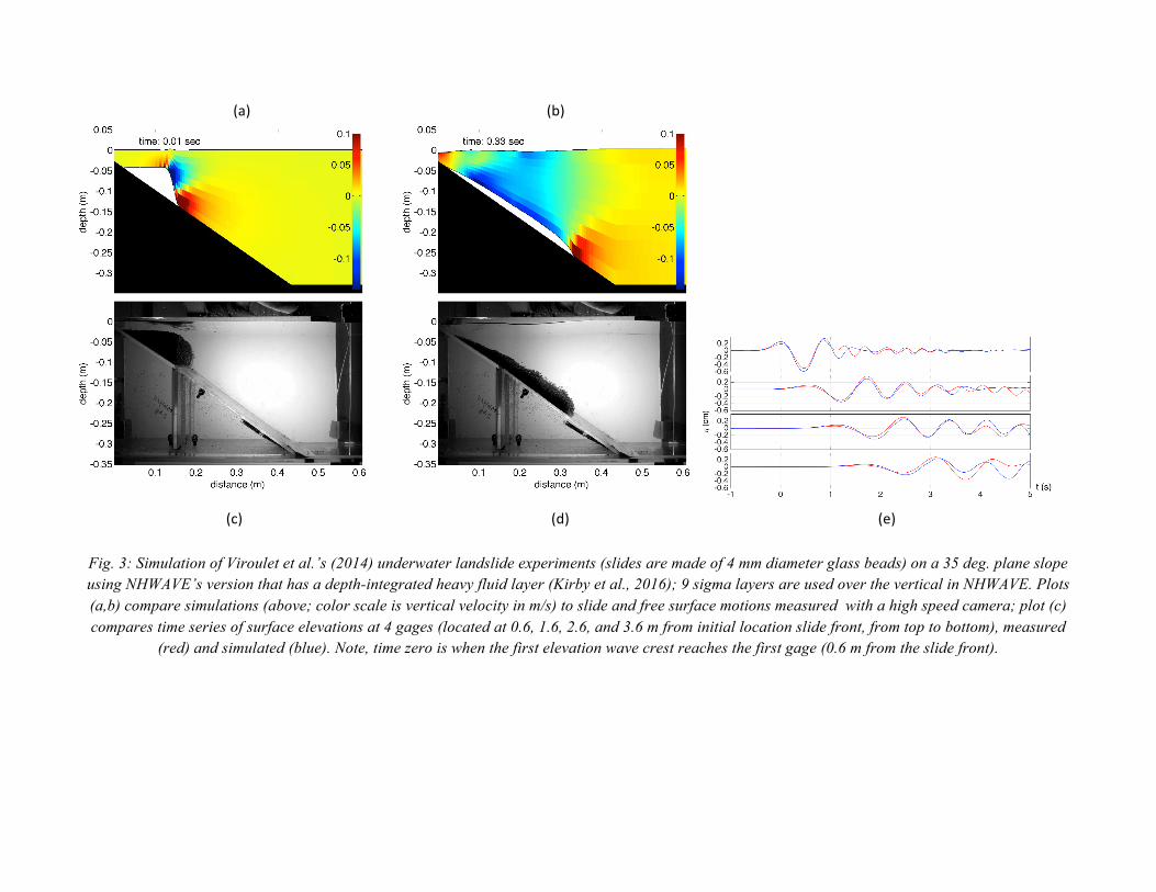
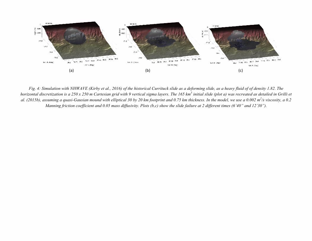
As SMF tsunami generation is reduced when the SMF is assumed to behave as a dense fluid rather than a rigid slump, it is important to use a calibrated/validated model in the tsunami source simulations (this also relates to Task 1 on Landslide tsunami model validation workshop). To this effect, a sensitivity analysis of tsunami generation to model parameters is being performed, by comparing results to laboratory experiments for granular flows (Viroulet et al., 2014; see Fig. 3) and by simulating the historical Currituck slide (Grilli et al., 2015b; see Fig. 4), when representing the SMF as a dense fluid layer (Kirby et al., 2016). Data available for the historical Currituck slide is used to guide the selection of model parameters.
In particular, it was found that slide acceleration and spreading, which are important for tsunami generation, are controlled in the model by the selection of the dense fluid viscosity, bottom friction and mass diffusion parameters. Both the laboratory experiments (Fig. 3) and the observed failure for the Currituck slide (Fig. 4) are used to find the best values for these parameters. Once this realistic set of model parameters is identified, the 4 SMF Currituck proxies will be fully simulated and results will be used to update inundation maps (e.g., Fig. 2).
Fig. 1: Location of historical Currituck slide complex and 4 areas where SMF-Currituck proxies are sited .
(a) (b)
(c) (d) (e)
Fig. 2. NHWAVE simulations of landslide tsunamis generated off of the Hudson River canyon (Area 1 in Fig. 1) assuming: (a,c) a rigid slump, modeled as a Currituck SMF proxy (Grilli et al., 2015a,b); (b,d) a deforming slide modeled as a dense fluid layer (Kirby et al., 2016), with same initial geometry, location, volume, and runout at the time the slump stops moving (12 min), as the Currituck SMF proxy. Panels (a,b) show in gray the SMF locations after 13.3 min (to the left of the Hudson River canyon), and panels (c,d) show the surface waves generated after 13.3 min (the black ellipses mark the initial footprint of the SMFs). At this time, wave patterns are similar but waves have lower elevations in the deforming slide case;black ellipses mark the initial footprint of each SMF. (e) solid curves are center of mass motions of (red) slump and (black) slide, with dash curves being curve fits of theoretical laws of motion.
(a) (b)
(c) (d) (e)
Fig. 3: Simulation of Viroulet et al.’s (2014) underwater landslide experiments (slides are made of 4 mm diameter glass beads) on a 35 deg. plane slope using NHWAVE’s version that has a depth-integrated heavy fluid layer (Kirby et al., 2016); 9 sigma layers are used over the vertical in NHWAVE. Plots (a,b) compare simulations (above; color scale is vertical velocity in m/s) to slide and free surface motions measured with a high speed camera; plot (c) compares time series of surface elevations at 4 gages (located at 0.6, 1.6, 2.6, and 3.6 m from initial location slide front, from top to bottom), measured
(red) and simulated (blue). Note, time zero is when the first elevation wave crest reaches the first gage (0.6 m from the slide front).
(a) (b) (c)
Fig. 4: Simulation with NHWAVE (Kirby et al., 2016) of the historical Currituck slide as a deforming slide, as a heavy fluid of of density 1.82. The horizontal discretization is a 250 x 250 m Cartesian grid with 9 vertical sigma layers. The 165 km3 initial slide (plot a) was recreated as detailed in Grilli et al. (2015b), assuming a quasi-Gausian mound with elliptical 30 by 20 km footprint and 0.75 km thickness. In the model, we use a 0.002 m2/s viscosity, a 0.2
Manning friction coefficient and 0.05 mass diffusivity. Plots (b,c) show the slide failure at 2 different times (6’40” and 12’30”).


![DO DISSOCIATING GAS HYDRATES PLAY A ROLE … · SUBMARINE SLOPE FAILURES? A CASE STUDY FROM THE ... several submarine landslides on the seaward slopes of the deformation ... [14]);](https://img.pdfslide.us/doc/110x75/5b77f3607f8b9aee298e13dc/do-dissociating-gas-hydrates-play-a-role-submarine-slope-failures-a-case-study.jpg)