Embed Size (px)
Citation preview

Canadian Coast Guard Auxiliary
(Central & Arctic)
Need Help W
ith POWER POINT?
YES?
1.Hold down the CTRLKey
and hit the A key at the same
time.
2.This shows the ARROW
3.Move the ARROW over the
word “Help” below, and click
the left button (or hit ENTER)
HELP
NO? Go ahead
Hit Space Bar or
Down Arrow
NEED HELP?

Canadian Coast Guard Auxiliary
(Central & Arctic)
SURVIVAL
NAVIGATION
This Version Compile
d
By Jim
Gram
With the Assistance of Don Lim
oges
January 2002
Canadian Coast Guard Auxiliary (Central and Arctic) Inc.
Click here for InstructorInform
ation

Canadian Coast Guard Auxiliary
(Central & Arctic)
TITLE PAGE

Canadian Coast Guard Auxiliary
(Central & Arctic)
NTHE EARTH
THE EARTH
MERIDIANS OF
LONGITUDE
PARALLELS OF
LATITUDE

Canadian Coast Guard Auxiliary
(Central & Arctic)
Latitude Numbers?
00°
30°SOUTH
30°NORTH
60°NORTH
90°NORTH
60°SOUTH
90°SOUTH
N
Canadian Coast Guard Auxiliary
(Central & Arctic)
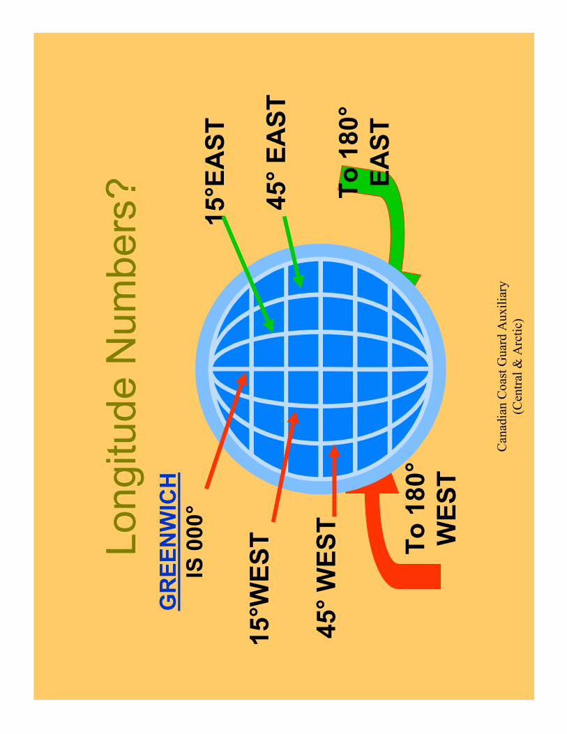
To 180°
EAST
To 180°
WEST
Longitude Numbers?
15°W
EST
45°WEST
15°EAST
45°EAST
GREENWICH
IS 000°

Canadian Coast Guard Auxiliary
(Central & Arctic)
A CHART IS A G
RID And M
AJOR
lines
(meridians)
of Longitude
With M
AJOR
lines
(parallels) of
Latitude

Canadian Coast Guard Auxiliary
(Central & Arctic)
TO LOCATE LATITUDE
080º05’
080º10’
40º15’
This line is
40º19.0’
This line is 40º15.6’
40º20’
Find the
Major
lines of
Latitude
Each
Minute is
divided

Canadian Coast Guard Auxiliary
(Central & Arctic)
TO LOCATE LONGITUDE
080°05’
080°10’
Each M
inute is split
into divisions
This line is
080º 11.2’
This line is
080º 07.6’
Find the MAJOR labeled lines of Longitude

Canadian Coast Guard Auxiliary
(Central & Arctic)
ON A
CHART
Find
Find
Latitude
Latitude
TO LOCATE A POSITION

Canadian Coast Guard Auxiliary
(Central & Arctic)
FIND
LATITUDE
45°38.4’N
45º30’
45º40’
080º20’
080º10’
45º38.4’N
Extend this line
as necessary

Canadian Coast Guard Auxiliary
(Central & Arctic)
ON A
CHART
Find
Find
Longitude
Longitude
TO LOCATE A POSITION

Canadian Coast Guard Auxiliary
(Central & Arctic)
45º30’
45º40’
080º20’
080º10’
080º13.0’
Extend this
line as
necessary
Find
Longitude
080°13.0’W
Canadian Coast Guard Auxiliary
(Central & Arctic)
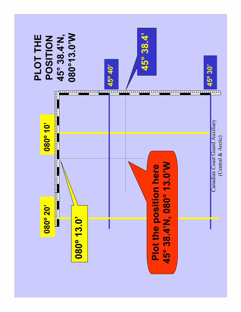
PLOT THE
POSITION
45°38.4’N,
080°13.0’W
45º30’
45º40’
080º20’
080º10’
080º13.0’
45°38.4’
Plot the position here
45°38.4’N, 080°13.0’W
Canadian Coast Guard Auxiliary
(Central & Arctic)
Measure Distance
Traveled

Canadian Coast Guard Auxiliary
(Central & Arctic)
Which Scale to Measure Distances?
Lines of Longitude
are different
distances apart
One M
inute = ???
Lines of Latitude
are always the
same distance
apart
One M
inute = 1 NM

Canadian Coast Guard Auxiliary
(Central & Arctic)
45º30’
080º20’
080º10’
3.2 NM
3.4NM
45º40’
Find
Distance

Canadian Coast Guard Auxiliary
(Central & Arctic)
60 D = ST
Distance (D) in Nautical Miles
Tim
e(T) in Minutes
Speed (S) in Knots
(KTS)
60 X D
S
60 X D
T
S X T
60
D =
T =
S =
Canadian Coast Guard Auxiliary
(Central & Arctic)
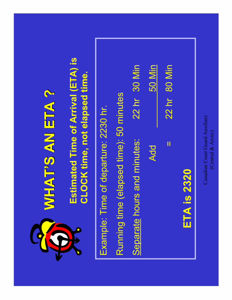
WHAT’S AN ETA ?
WHAT’S AN ETA ?
Estimated Tim
e of Arrival (ETA) is
CLOCK tim
e, not elapsed tim
e.
Example: Tim
e of departure: 2230 hr.
Running tim
e (elapsed tim
e): 50 m
inutes
Separate
hours and m
inutes:
22 hr
30 M
in
Add _______50 M
in
=22 hr
80 M
in
ETA is 2320
Canadian Coast Guard Auxiliary
(Central & Arctic)
BEARINGS

Canadian Coast Guard Auxiliary
(Central & Arctic)
THE COMPASS ROSE
THE COMPASS ROSE
N
090º
180º
270º
000º
The Outside scale gives
TRUE readings. USE
THIS FOR CHARTWORK
The Inner Scale
shows Compass
Variation
Canadian Coast Guard Auxiliary
(Central & Arctic)
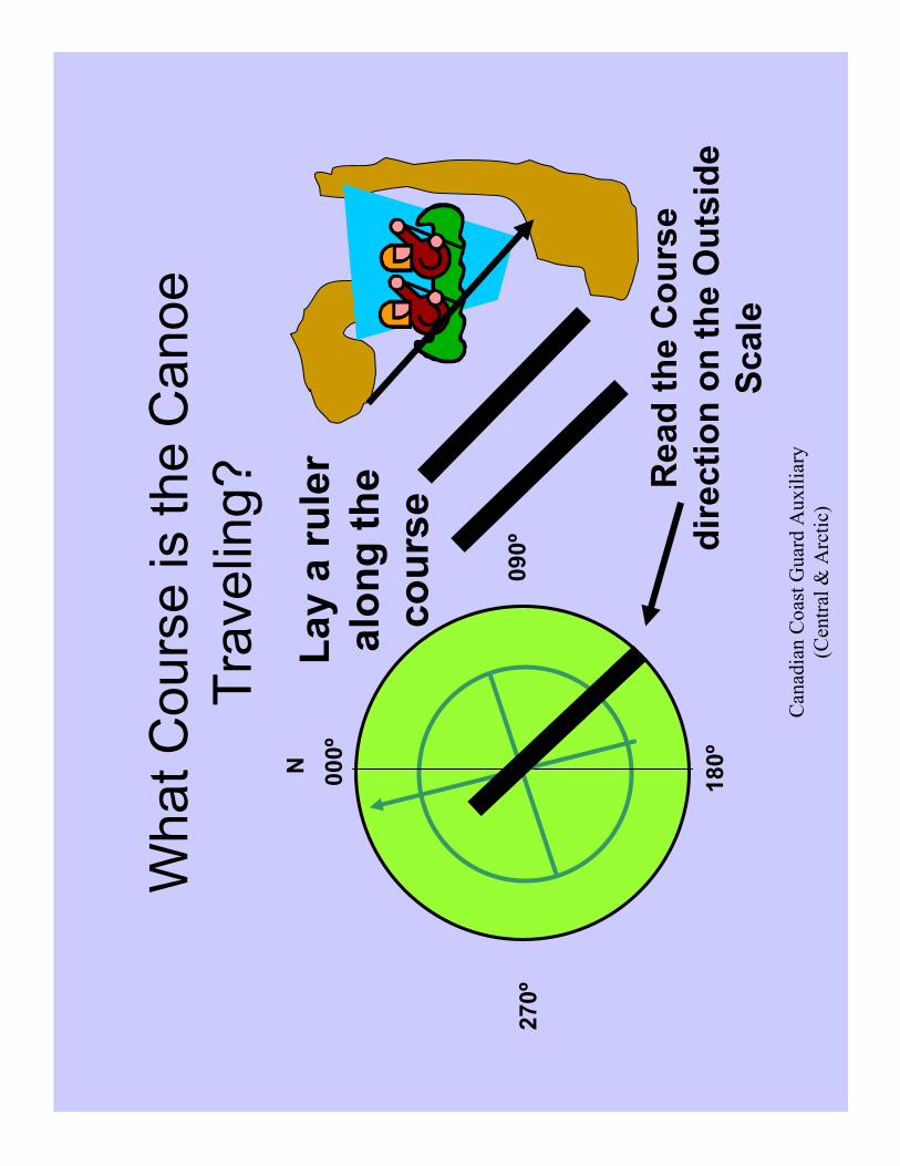
What Course is the Canoe
Traveling?
N
090º
180º
270º
000º
Lay a ruler
along the
course
Read the Course
direction on the Outside
Scale

Canadian Coast Guard Auxiliary
(Central & Arctic)
Finding a Bearing of 220°
Off (from) the Beacon
N
090º
180º
270º
000º
Use OUTSIDE SCALE.
Watch DIRECTION
THIS is 220º
This is a
BEARING
of 220º
FROM the
Beacon.

Canadian Coast Guard Auxiliary
(Central & Arctic)
END
Canadian Coast Guard Auxiliary
(Central & Arctic)
OPTIONAL

Canadian Coast Guard Auxiliary
(Central & Arctic)
HINTS FOR USING POWER POINT
For a Full List of commands, Go to
Slide Show / View Show / F1
•Move FORWARD
•Right or Down Arrow
•Page Down
•Space Bar
•N
•Move BACKWARD
•Left or Up Arrow
•Page Up
•Back Space
•P
•Show the ARROW:CTRL A
•To Hide it: CTRL H
•Show the PEN:CTRL P
•To Hide it: CTRL H
Change Pen Colour: Right Click, Pointer Options,Pen Colour
End the Presentation: ESC
JUMP DIRECTLYto a slide:
Slide N
umber and Return
Return to the First Slide: Home
OK? Then:
Hit: 2 and RETURN, or,
Click on
Start Slide Show: F5
Canadian Coast Guard Auxiliary
(Central & Arctic)
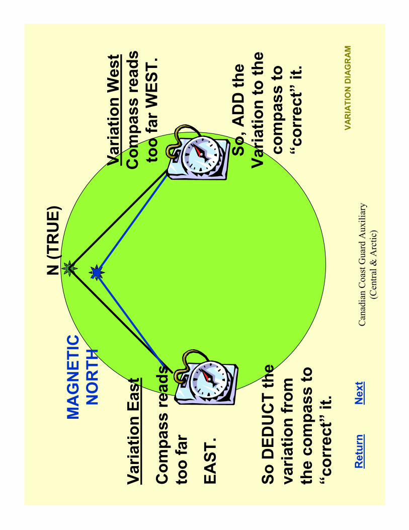
VARIATION DIAGRAM
N (TRUE)
MAGNETIC
NORTH
Variation W
est
Compass reads
too far WEST.
So, ADD the
Variation to the
compass to
“correct” it.
Variation East
Compass reads
too far
EAST.
So DEDUCT the
variation from
the compass to
“correct” it.
Return
Next

Canadian Coast Guard Auxiliary
(Central & Arctic)
(4(4’’ WW
))Variation is
increasing to the W
est
by 4’(four minutes)
each year.
4’x 15 Years = 60’= 1°
N
000°
180º
270º
180º
The Compass Rose and Variation
010 W 199
9 (4’W)
Look here along the arrow:
Example: 010
010ººW 1999 (4
W 1999 (4’’W)
W)
010
010°° W
1999
W 1999
In 1999
Variation was 010°WEST
Return

Canadian Coast Guard Auxiliary
(Central & Arctic)GREENWICH
U.K.
Is on the Thames River a
short distance east of
London England. It is
located on Longitude
000°.
Longitude is m
easured from the 000°M
eridian to 180°
to the W
est, and to 180°to the East.
The tim
e at Greenwich (Greenwich Mean Tim
e, or
Coordinated Universal Tim
e, or Z) is the “base”time
for most military, naval, coastal navigation, celestial
navigations tables and the like. (Except CCGA).
Canadian Coast Guard Auxiliary
(Central & Arctic)
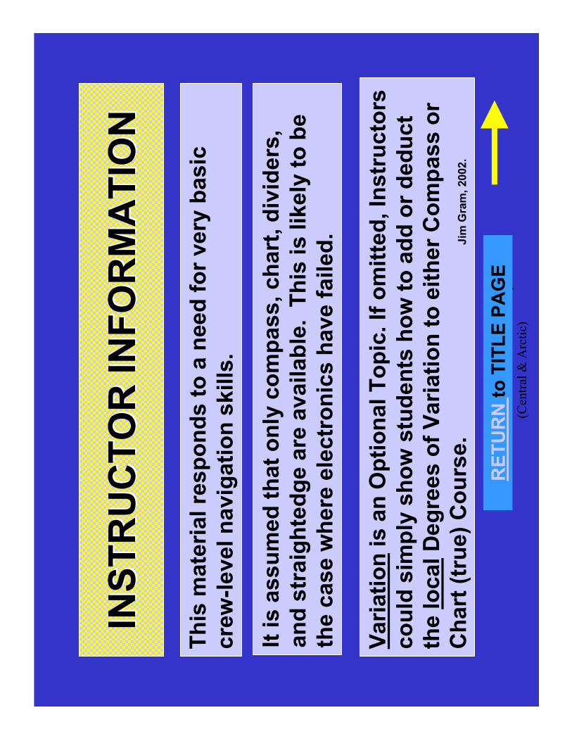
INSTRUCTOR INFORMATION
INSTRUCTOR INFORMATION
This m
aterial responds to a need for very basic
crew-level navigation skills.
It is assumed that only compass, chart, dividers,
and straightedge are available. This is likely to be
the case where electronics have failed.
Variationis an Optional Topic. If omitted, Instructors
could sim
ply show students how to add or deduct
the localDegrees of Variation to either Compass or
Chart (true) Course.
Jim
Gram, 2002.
RETURN to TITLE PAGE

Canadian Coast Guard Auxiliary
(Central & Arctic)
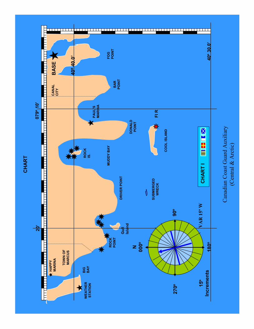
USING THE CHART
The following slide contains an over-sim
plified diagram-type
“chart”. This, or a sim
ilar chart, is easily reproduced so each
student can have a copy and perform
the skills as the
presentation unfolds. This “chart” can be useful to develop
basic principles and skills without some of the distractions ofa
real chart.
The slide containing the attached chart can be copied to your
word processing program for modification, copied to a new slide
and m
odified here, or printed directly for use in your instruction.
To print directly from the slide, be sure to use
“Landscape” orientation, and check “Scale to fit
paper”. The chart will then fill an 8 ½ x 11 page.
RETURNto TITLE PAGE
Canadian Coast Guard Auxiliary
(Central & Arctic)
BASE
BAR
POINT
ROCK
IS.
HAPPY
MARINA
BIG
BAY
ROCK
POINT
Gull
Island
FOG
POINT
WEATHER
STATION
TOWN OF
MARCUS
CANAL
CITY
PAUL’S
MARINA
40° °°°30.0’
079° °°°10’
20’
CHART I
40º 40.0’
SUBMERGED
WRECK
COOL ISLAND
Fl R
DONALD
POINT
DRIVER POINT
MUDDY BAY
N
000° °°°
90° °°°
180° °°°
270° °°° 15° °°°
Increments
VAR 15º W
CHART

Canadian Coast Guard Auxiliary
(Central & Arctic)
LINKS
BACK TO PREVIOUS PAGE ( Click UP ARROW )
RETURN to TITLE PAGE
RETURN TO INSTRUCTOR -INFORMATION
Back to Slide 1 hit HOME