Embed Size (px)
Citation preview

MAE' NO.: ASSESSMENT REPORT X PROSPECTUS CONFIDENTIAL X
115 F' 15 OPEN PILE
DOCUMENT NO: 032580 MINING DISTRICT: Mayo TYPEOP WORK: Geochemical
REPORT PILED UNDER: Walhala Explorations Co. Ltd
DATE PWORMED: 17-30 June, 1388 DATE FILED: 27 October, 1388
LOCATION: LAT. : 63'57'~ AREA: Red Mountain
LONG.: 136'45'~ VALUE $: 18 000.00 - -
CLAIM NAME 5 NO,: 110130 1-52(YA83!322-36, YA83703-44)
WORK DONE BY: G.S. Davidson
WORK DONE FOR: Walhala Exploration Ltd
DATETOMODSTANDING: I REMARKS: 115 llOl30
1 i
In 1388, contour soil smpling, silt sampling and prospecting were were followed up by 4 blast trenches. An arsenopyrite-stibnite- quartz vein exposed in trench #1 returned values in excess of 10 g/t
I I Au.

Indian and Northern Affaires indiennes + Affairs Canada et du Nord Canada
TRANSMITTAL FOR
-
L
- ~
:or action are: Name
NEW APPLICATION FOR PLACER LEASE TO PROSPECT I 1 Name
RENEWAL APPLICATION PLACER LEASE TO PROSPECT 1 rase I I
AFFIDAVIT OF EXPENDITURE ON PLACER LEASE lN ame I
SECURITY DEPOSIT
FINANCIAL ABILITY
ASSIGNMENT OF PLACER LEASE NO. rrom GROUPING APPLICATION Owner UNDER SEC. 52(2) PLACER MINING ACT.
PIaims
,Claim sheet no. [7 DIAMOND DRILL LOGS
I I
Claims laim sheet no. a QUARTZ ASSESSMENT REPORT I do 130 / - <a
lDate returned ,

Indian and Northern Affaires indiennes Affairs Canada et du Nord Canada
TRANSMllTAL
M.R. file no.
R.M.M.R. file no. \
I
Qd 'rom ) Mining Recorder at: W
To ) Regional Manager, Mineral Rights at Whitehorse, Y.T.
or action are: Name
NEW APPLICATION FOR PLACER LEASE TO PROSPECT I I - .Name ,Lease no. U RENEWAL APPLICATION PLACER LEASE TO PROSPECT I
- ,Name ,Lease no. U AFFIDAVIT OF EXPENDITURE ON PLACER LEASE I I
SECURITY DEPOSIT
FINANCIAL ABILITY
[7 ASSIGNMENT OF PLACER LEASE NO.
0 GROUPING APPLICATION Owner UNDER SEC. 52(2) PLACER MINING ACT.
,Claim sheet no. DIAMOND DRILL LOGS


This report has been exami::ed by the Geological Evaluation Unit under Section 53 (4) Yukon Quartz Mining Act and is allowed as representation work in the amount of $ / t i w . k . - ,?
b of h o n Territory.

ASSESSMENT REPC%IT
on the
HOBO 1-52 Mineral Claims YA89922 - YA89936, XU3709 - YA83744
NTS 115 P-15 &yo and D a m Mining Districts
Latitude 630 57' N, lhngitude 1360 45' W
For :
EY : G.S. DAV133SONt P. m L .
1988
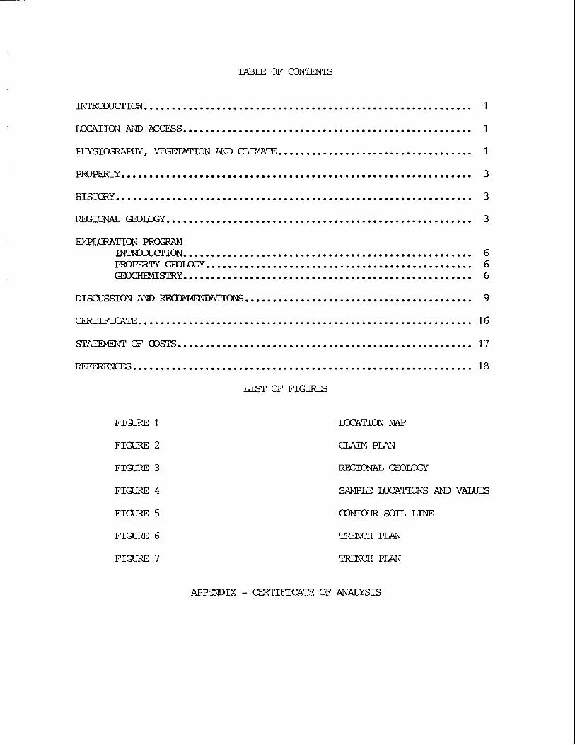
TABLE OF 03NTENTS
......................................... DISCUSSION IW IZMX)pIp.IENDATIOI.Js 9
STATEMENT OF 03SIIS ..................................................... 17
-CES ............................................................. 18
FIGURE 1
FIGURE 2
FIGUP* 3
FIGURE 4
FIGURE 5
FI- 6
FIGu'EIE 7
LIST OF FIGURES
LQCATION Y !
CLAD1 PLAN
REGIONAL, m m
SAMPLE ~ T I O N S AND VALUES
03NTOUR SOIL LINE
m C H PLAN
m C H PLAN
APPENDIX . CERTIFICATE OF ANALYSIS

This report describes posped ing and sampling work performed on the BED 1-52 claims fran June 17 - 30, 1988. The claims cover go16 bearing arsenopyritequartz veins occurring in cpssanous Ordovician quartzite cn the steep south facing side of Red mantain. The writer spent three days on the property and reviewed rock and s o i l sampling surveys mrducted by a threeman crew fran Walhalla Explorations Co. Ltd.
LQCATION AND ACCESS
The property is located 65 km northwest of Mayo, Yukon m the west side of Red Pbuntain on ITIS Map Sheet 1 15 P-15. Figure 1 s k s the property location.
The claims are accessible by helicopter £ran Mayo. Rcad access is possible on a rough f a r wheel drive road that l inks a placer operation on Gem Creek to the C l e a r Creek roacl, which handles off the Klondike Highway. Tne 80 km t r i p fran the highway to Gem Creek is reported to take up to 12 hours however upgrading of the l a t t e r part of this mad muld substantially reduce the travel time.
PHYSIOGRAPHY, IELETATIOK, CLIMATE
Red Ivbuntain a t 1800 m is a prceninent peak a t the south end of the Ogilvie ikxmtains. The claims cover w e s t and northwesterly t r a d i n g ridges exteding from the summit of Red muntain. Edge crests are rounded with limited outcrop a t higher elevations. H e r a t e to steep slopes des& from the ridge crests a t the headwaters of Gem, Sprague and HOBO Creeks. Precipitous slopes with abundarlt outcrop are limited. to the south face of Red bbuntain. Felsenmeer is carurn along ridge crests.
Alpine areas feature nloss a d grass average, while vegetation a t lower elevations consists of spruce forest and buck brush.
The exploration season las t s £ran June to late Septe~ber. Winters are long and cold while smrer temperatures average 120 C.


PFaPrnTY
The HOBO 1-52 claims are held by Walhzlla Explorations Co. Ltd. i n the Phyo ard Dawson mininq d i s t r i c t s . recorded on August 26, 1987. 1 lists the property data.
CLAM NXm
iied ?.buntain was or ig ina l ly
They w e r e sWced on August 18, 1987 and The claim plan is shorn in Figure 2 an6 Table
TABLE 1 CLAIM DATA
W T i r H x L A EXPL. 0. LTD.
MINIIG WIRY DISTRICT DATE
DAWSON 26 AUG. 1992
MAY0 26 AUG. 1991
DAWSOii 26 AUG. 1992
my0 26 AUG. 1991
staked as the Hbbnail claims i n 1923. Treadwell Yukon Consolidated trenched arsenopyrite-quartz veins i n the l a t e 1920's. The property was restaked by A. Abverson and J. Drapeau i n 1933, and again by C. Po l i i n Ju ly , 1947. Asarco a d Amax of Canada staked Red >buntdin i n 1977 and 1979 respectively. The recent workers prfozmed geochemical geological [email protected] surveys.
Placer gold bearing gravels have k e n m i n d on @-n Creek, Eobo m d Sprague Creeks.
The Red bbuntairi area is underlain !by sedinentary and mtasedimentary rocks of Protarozoic and Paleozoic aye intruded by Wies of g ran i te , syeni te , d i o r i t e and gabbro of ,Jurassic ancl/or Cretaceous age. The geology of the d i s t r i c t w a s published as %ip 1143 A by t he G.S.C. Figure 3 shows t ?e regional geology.
Yukon Group s ch i s t , phy l l i t e , quar tz i t e and limestone covers mch of the ara sou t l of +As p r o p r t y . Yukor; Group rocks are unconfonmbly overlain by Ordovician o r younger irkerkdded cherty quar tz i tes , black s l a t e , pebble conglmerate and limestone. Cretacems and Jurass ic in t rus ive bodies have fractured and s i l i c i f i e d the surrounding sdiments . Quartz veins occur in the metzsediments c lose t o g ran i te contacts. Some of the veins contain gold bearing arsenopyri te .


QUATERNARY
2 1 S u r f i c i a l depos i ts , und i v i ded 19 Stream depos i ts , a l l u v i u m
JURIASSIC AND/OR CRETACEOUS 14 COAST INTRUSIONS, g ran i t e , g r a n o d i o r i t e , q u a r t z monzonite 12 Gabbro, p e r i d o t i t e , s e r p e n t i n i t e , d i o r i t e
ORDOVICIAN OR LATER 9 Q u a r t z i t e , s l a te , sandstone, conglomerate 8 Limestone, s l a te , p h y l l i t e , q u a r t z i t e
ORDOVICIAN OR EARLIER 7 Va r i aco loured s l a t e 6 Q u a r t z i t e , s l a te , p h y l l i t e , l ime tone 4 YUKON GROUP, s c h i s t , q u a r t z i t e , p h y l l i t e , l imestone
- FIGURE 3
REGINAL GEOLOGY MTS 115 P-15
SYMBOLS 0 I500 3000 I Geolog ica l Contact I I ---
Bedding, s t r i k e and d i p 60 M E T E @

On June 17, 1988 a three-man f i e ld c r e w mobilized onto the HIE0 claims, locating camp at 4300 ' elevation beside Gem Creek. Trans North Air, based in Mayo provided a i r support.
The c r e w performed contour soil sampling, stream sediment sampling and prospecting. Figure 4 shcrws sample locations and values. A l s o , four b las t trenches were excavated an quartz veins.
One hudred and twenty soil samples were collected and a selective twenty s i x samples were analyzed for Au-Ag by Pmdar-Clegg laboratories. Figure 5 shows the contaUr soil results. Eleven sediment samples w e r e collected f m HOBO and Gan Creeks. Sampling involved washing two f u l l pm of silt and gravel down to a concentrate, which was then bagged fo r analysis.
W r t y eight d. samples were collected rn p o s p c t i n g traverses. Sixteen selective samples were sutrnitted for analysis fo r Au-Ag.
The writer collected a further nine rock samples from the blas t trenches. Figures 6 and 7 show the trench plans.
The property is underlain by Ordavician quartzite and s l a t e which is locally s i l i f i e d and witic. Gossanaus quartzite and i n t ~ ~ e d s l a t e outcrop across the south side of Red Pbuntain and along ridge crests. The metasediments are intruded by a lense of b io t i t e granite on the mrthwestern flank of Red l%untain.
Previous workers located four d io r i t e dykes on the southern ard mrthwestern end of the property (Kidlark, R.G.). They a lso mpped basic volcanic breccia and flaws on the eastern margin of the claim block.
SOIL - Contaur soil l ines w e r e run across a prominent gossan on the south face of Red Pbuntain. Werate to strongly anomalous gold values (up to 351 ppb) w e r e cbtained £ran 2+50E - 7+00E aid a t 9+50E.
- Samples OT 1-4 were collected f r m an old trench south of camp. The trench v m s excavated using a ground sluice a& dimensions are 50 m long, 1 m wide and .75 m deep. Gold values (see Figure 4 ) are strongly anmlous . Th2 trench cuts orange weathering quartzite and s l a t e containing minor ~;yr-ite.


SmII\lENT - Pan concentrate samples recorded high gold values m all creeks tested. A peak gold val~e of 5000 ppb was obtained on HOB3 Creek.
ROCK - Rock sanple values and descriptions are listed in Table 2. %my of the si~a-tples returned ancrnalous gold values. The strength of the gold value depends directly on the amount of arsenopyrite in the sample. The highest gold values ( >I 0,000 ppb) were £ran an arsenopyrite-stfinite-quartz vein which was exposed in and below Trench #I. The shaving consists of a 2-5 an wide bardi of mssive arsenopyrite and stibnite in quartz gangue. This is the original mineral occu~~ence investigated by Treadwell Yukon Cansolidated in the late 1920 Is. Tne sulphide bards were traced downslope for 30 m however the mineralizatim is very narrow.
Other quartz samples recorded gold values of less than 1000 ppb. 'Ihe vein widths vary fran 5-25 an and generally contain minor pyrite, sericite and arseropyrite. Several quartz veins containing quartzite fragments and manganese staining recorded silver values up to 12.9 ppn.
TRENCHING - Four quartz veins were blast-trenched on the proprty. Trench #I exposes a narrow arsenopyrite-stibnite-quartz vein. Figure 6 shows the trench plan.
Trenches 2 and 3, sham in Figure 7, expose a quartz-breccia zone. The vein contains fragments of quartzite in a mganese stained, pyrite quartz matrix.
DISCUSSION AND FGXDM?iJGJDATIONS
The sampling program has atlined consistently anmalous gold values m the HOED claims. 'lho types of mineralization are present:
1 ) gossanous quartzite mtaining minor pyrite and arsenopyrite assays 200 - 500 ppb Au;
2 ) narrow arsenopyrite-stibnite bearing quartz veins assay greater than 10,000 ppb Au.

$4 MPLE A u N U M B E ~
A 3 PPB PPH
63651 569 1.3
6 3 6 5 2 212 O.B
6 3 6 5 3 >lo,ooo 23 .7
6 3 6 54 71 1 0.6
6 3 6 5 6 > l0,Ood 750.0
F ; S ~ r z 7: TRENCH PLAN

The low and higher grade mineralization occurs near granite contacts. Detailed sampling, VLF-EN and nagnetmeter surveys should bc un3ertaL.n to try ad define gold k i n g areas. Once identified these targets should be cat trenched. Tne following program is gcpsed:
Grid developnent (picket gr id) C ~ e m i s t r y 750 samples Geology and supervision W-EM and mgnetmetex surveys Camp ard supplies Transportation Report and assessmerit
Total Costs

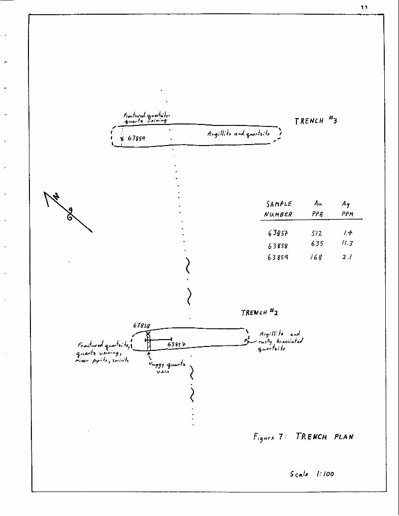
TABLE 2 RCXX SAMPLE VALUES AND DESCRIPTIONS
Description
40 an. chip Trench #I kac tured quartzite and orange-white 569 clay gouge zone
125 cm. chip Trench #1 Fractured quartzite, sane breccia, no 21 2 v is ib le sulphides
grab
grab
Trench #1 Pkssive arsenopyrite vein, 2 a n wide >10,000
Old p i t bellow Trench #I
Quartz vein, vuggy, f ine grained, 71 1 sericite, no visible sulphides
Same a s above Massive arsenopyrite-stibnite and > I 0,000 quartz vein, 4 an wide
30 m kellow Trench #I
klassive aresnopyri-te-stibnite i n 9,880 c p a r t z vein, 20 an wide
150 an. grab Trench #2 Brecciated quartzite, quartz veins, 51 2 minor arsenopyrite
Trench #2 kggy quartz vein, 10 a n wide, minor 635 arsenopyrite and s t ibni te
Trench #3
Trench #4
Fractured quartzite, narrow quartz veins
Fractured quartzite, lirnoni te in 7 5 fractures
f loa t Quartzite, arsenopyrite coating in 92 fractures
TABLE 2 RCX;?< SAMPLE VALUES AND DESCRIPTIONS
TABLE 2 ( 0 3 ' L Q r n )
Sample No. Sample Location . TY'P
Quartz vein, vuggy, no visible sulphides
Quartz breccia vein containing quartzite fragments, vuggy, limonite, Ph staining
Quartz-f eldspar-biotite qrani te , up to 2% disseminated pyrite an3 arser~~yrite
Quartz vein, sericite, no v is ib le sulphides
Actinolite slam, vuggy, Mn staining
Qualrtzite, highly oxidized and fractured, Pln ELnli l h n i t e staining
W r t z vein, no visible sulphides
Quartz vein, ininor pyrite anc3 swcicite

TABLE 2 ROCK S A l v Z P L Z VAWTES AND DFSCRIKTIONS
TABiE 2 ((X>bJTINUED)
Sample No. Description
float
Diorite, disseminated pyrite 12
W r t z vein, stibnite-arsenopyrite 2820 lenses
@uartz vein, limonite and sericite, minor write
Quartz vein, minor arseopyrite and pyrite
Quartzite, yellm; teathering, oxidized, cinibar
Quartzite, brecciated, narrow quartz veins
Quartz vein, vuggy, minor arsenopyrite

I, GRAHAl4 DAVIDSON, of the City of Whitehorse, in the Yukon Territory,
!Ibt I am a consulting geologist and that I supervised and participated in the work program described in this report.
That I am a graduate of the University of Western Ontario (H.E.Sc., Geology, 1981 ).
That I an registered as a Professional Geologist by the Association of Professional Engineers, Geologists ard Geophysicists of Alberta (#423O8) . Tnat I have been engaged in mineral exploration on a full and part t h basis for seven years, of which five have Seen spent in the Yukon, Northwest Territories and British Columbia.
at Whitehorse, Yukon this 13 day of October, 1988.

Yapping - Blow-ups Explosives Groceries H o t e l Travel Expenses, camp r en t a l s , too l s Remote Sensing Truck Rental
Helicopter June 17th - Move in and prepire exploration
4.9 hrs. 3,003.70 June 27t3-1 R e t u m frm Mayo 0.9 hrs. 551 -70 June 30th Yme Out 2.0 hrs. 1,226.00
Assays
Waqes Camp preparation and t r ave l
3 man days @ $250 .OO/day Personnel Mike Glynn 12 days a t $250 .OO/day lhve Sufady 1 4 days a t $250,00/day S i i i Ridgway 1 4 days at $25O.OO/day O f f ice 2 days a t $200.0O/day
Geologist 4 days a t $25O.OO/day Expenses - Truck, Gasoline
Report FYepration, Pr int ing, Typing
lbtal Costs:

Kidlark, R.G. 1980, 1979 Geological and Geochemical Assessrent Report on the Red ?h.Intain Broprty for Amax of Canada Ltd.
Geological Survey of Canada.


![Abstract arXiv:2006.08509v1 [cs.LG] 15 Jun 2020 · No training during search X X X No evaluation during search X X Channel pruning X X Mixed-precision quantization X X X joint model](https://img.pdfslide.us/doc/110x75/5f605d3fe5d64247e14180b7/abstract-arxiv200608509v1-cslg-15-jun-2020-no-training-during-search-x-x-x.jpg)


![:HSTCQE=V[[\X]: Strategic Environmental Assessment in](https://img.pdfslide.us/doc/110x75/5895a7ed1a28ab465c8b74ad/hstcqevx-strategic-environmental-assessment-in-.jpg)