Embed Size (px)
Citation preview

Nine Mile Creek Regional Trailmaster plan
December 19, 2013
i Three Rivers Park District
the mission of Three Rivers Park District is to promote environmental stewardship through recreation and
education in a natural resources-based park system.
Three Rivers Park District was established in 1957 after legislation was enacted in 1955 allowing for the activation of park districts whose primary duties are “acquisition, development and maintenance of large parks, wildlife sanctuaries, forest and other reservations, and means for public access to historic sites and to lakes, rivers and streams and to other natural phenomena” (Minnesota State Statutes, Chapter 398.07).
There are 9.3 million annual visits to more than 26,500 acres of park reserves, regional parks and special-use areas in Hennepin and five adjoining counties and 120 miles of regional trails. Current outdoor-recreation activities in regional parks and trails include camping, hiking, cross-country and downhill skiing, tubing, bicycling, in-line skating, horseback riding, nature interpretation, golfing, fishing and swimming. Three Rivers Park District also operates a natural resources management program, which administers the restoration and perpetuation of both native wildlife and plants in order to provide park and trail visitors opportunities for high-quality recreational experiences.
Board of Commissioners
Jennifer DeJournett, District 2Term Expires 12/31/14
• Brooklyn Park (all precincts except W1-0 & W1-R), Champlin, Dayton, Maple Grove, Osseo
Daniel Freeman, Vice Chair, District 3Term Expires 12/31/16
• Brooklyn Center, Brooklyn Park (only precincts W1-0 & W1-R) Crystal, Golden Valley, Hopkins (precinct 2), Robbinsdale, St. Anthony, St. Louis Park
Penny Steele, District 1Term Expires 12/31/16
• Corcoran, Greenfield, Hanover, Independence, Long Lake, Loretto, Maple Plain, Medicine Lake, Medina, Minnetrista, Minnetonka Beach, Mound, New Hope, Orono (precincts 1, 3 & 4), Plymouth, Rockford, Rogers, Spring Park, St. Bonifacius, Wayzata
John Gunyou, Chair, District 4Term Expires 12/31/14
• Deephaven, Edina, Excelsior, Greenwood, Hopkins (all precincts except 2), Minnetonka, Orono (precinct 2), Richfield (all precincts except 6 & 9), Shorewood, Tonka Bay, Woodland
John Gibbs, District 5Term Expires 12/31/16
• Bloomington, Chanhassen, Eden Prairie, Fort Snelling, Richfield (precincts 6 & 9)
Larry Blackstad, Hennepin County AppointeeTerm Expires 12/31/14
• Serves at large
Steven Antolak, Hennepin County AppointeeTerm Expires 12/31/16
• Serves at large
iiNine Mile Creek Regional Trail Master Plan, December 19, 2013
AcknowledgementsThree Rivers Park District (Park District) gratefully acknowledges the staff, community members and other project participants who contributed to content of the Nine Mile Creek Regional Trail Master Plan.
The Park District extends a special thank you to the individuals listed below who provided guidance, time, questions, and critical insight throughout the process.
Cris Gears, Superintendentand Secretary to the Board
Thomas K. McDowell, Associate SuperintendentDivision of Recreation, Education & Natural Resources
Margaret A. Dahlof, Associate SuperintendentDivision of Strategic Initiatives
Boe R. Carlson, Associate SuperintendentDivision of Park & Trail Operations
Jonathan Vlaming, Associate SuperintendentDivision of Planning, Design & Technology
Howard Koolick, Director of FinanceChief Financial Officer
Mark ThemigGeneral Manager of Regional Parks, Scott County
Leadership Staff
City Representatives Park District Project Staff
City of HopkinsJohn Bradford, City EngineerSteve Stadler, Public Works Director
City of MinnetonkaDarin Ellingson, Public Works Operations ManagerPerry Vetter, Assistant City Manager
City of EdinaAnn Kattreh, Parks and Recreation DirectorBill Neuendorf, Economic Development ManagerChad Miller, Assistant City EngineerJohn Keprios, Parks and Recreation Director (retired)Mark Nolan, Transportation PlannerRoss Bintner, Environmental EngineerSusan Faus, Parks and Recreation Assistant DirectorWayne Houle, Director of Engineering
City of RichfieldJeff Pearson, Transportation EngineerKristin Asher, City EngineerMike Eastling, Public Works Director
City of BloomingtonTom Bowlin, Civel Engineer EITJulie Farnham, PlannerRandy Quale, Parks and Recreation Division Manager
Agency Representatives
Metropolitan Airports CommissionAllen Dye, Airport Project Manager
Nine Mile Creek Watershed DistrictKevin Bigalke, District Administrator
Amy Gurski, Director of DesignAnn Rexine, PlannerEric Nelson, Senior Manager of Civil EngineeringHeather Kuikka, Administrative Specialist - PlanningKelly Grissman, Director of Planning

Three Rivers Park Districtiii
This page left intentionally blank
ivNine Mile Creek Regional Trail Master Plan, December 19, 2013
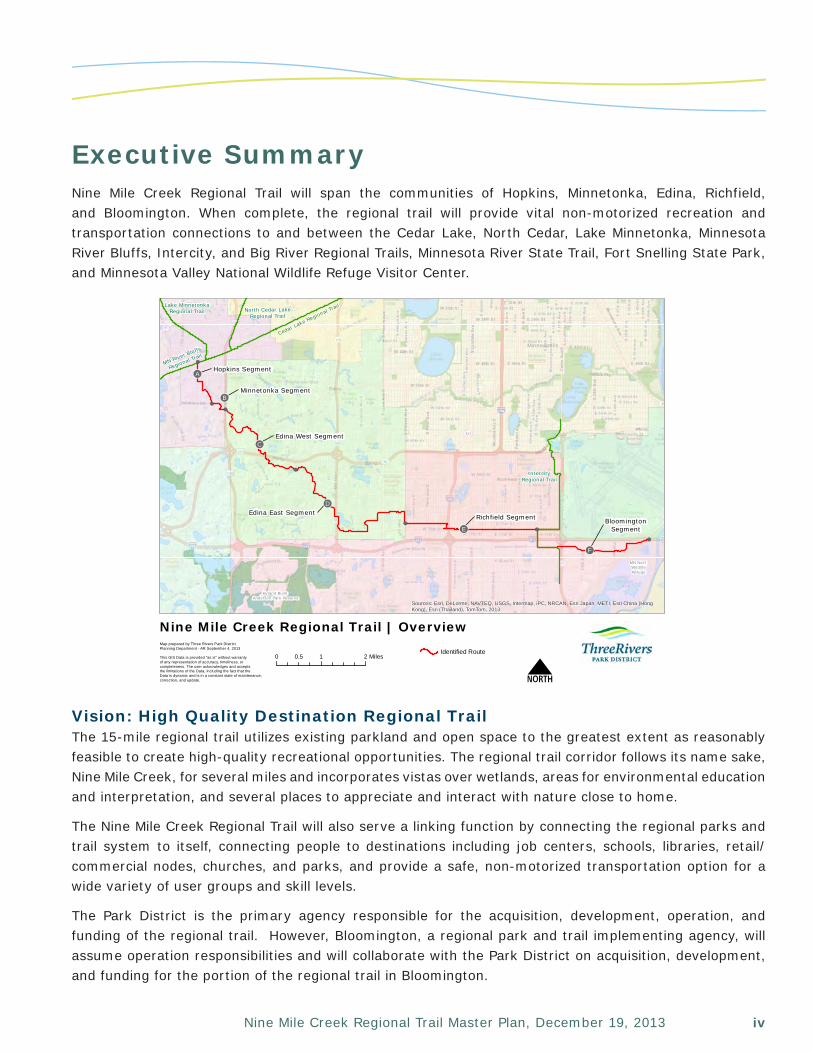
Executive SummaryNine Mile Creek Regional Trail will span the communities of Hopkins, Minnetonka, Edina, Richfield, and Bloomington. When complete, the regional trail will provide vital non-motorized recreation and transportation connections to and between the Cedar Lake, North Cedar, Lake Minnetonka, Minnesota River Bluffs, Intercity, and Big River Regional Trails, Minnesota River State Trail, Fort Snelling State Park, and Minnesota Valley National Wildlife Refuge Visitor Center.
Vision: High Quality Destination Regional TrailThe 15-mile regional trail utilizes existing parkland and open space to the greatest extent as reasonably feasible to create high-quality recreational opportunities. The regional trail corridor follows its name sake, Nine Mile Creek, for several miles and incorporates vistas over wetlands, areas for environmental education and interpretation, and several places to appreciate and interact with nature close to home.
The Nine Mile Creek Regional Trail will also serve a linking function by connecting the regional parks and trail system to itself, connecting people to destinations including job centers, schools, libraries, retail/commercial nodes, churches, and parks, and provide a safe, non-motorized transportation option for a wide variety of user groups and skill levels.
The Park District is the primary agency responsible for the acquisition, development, operation, and funding of the regional trail. However, Bloomington, a regional park and trail implementing agency, will assume operation responsibilities and will collaborate with the Park District on acquisition, development, and funding for the portion of the regional trail in Bloomington.
Minneapolis
!(
!(
!(
!(
!(
Cedar Lake Regional Trail
Hopkins Segment!!A
Minnetonka Segment
Edina West Segment
Edina East SegmentRichfield Segment
!!E
!!B
!!C
!!D
BloomingtonSegment
!!F
Hyland Bush Anderson Park Reserve
!(
!(
MN Nat'l WildlifeRefuge
MN River Bluffs
Regional Trail
Lake MinnetonkaRegional Trail North Cedar Lake
Regional Trail
IntercityRegional Trail
Sources: Esri, DeLorme, NAVTEQ, USGS, Intermap, iPC, NRCAN, Esri Japan, METI, Esri China (HongKong), Esri (Thailand), TomTom, 2013
0 1 20.5 Miles
Nine Mile Creek Regional Trail | Overview
NMap prepared by Three Rivers Park DistrictPlanning Department - AR September 4, 2013
This GIS Data is provided "as is" without warranty of any representation of accuracy, timeliness, or completeness. The user acknowledges and acceptsthe limitations of the Data, including the fact that the Data is dynamic and is in a constant state of maintenance,correction, and update.
Identified Route
Three Rivers Park Districtv
Planning and Public EngagementThe Park District conducted an extensive planning and public engagement process. As part of the process, the Park District worked off of and in conjunction with the success of many existing planning efforts including the First Tier Parks, Trails, and Greenway Master Plan – the originating source of the Nine Mile Creek Regional Trail vision, collaborated closely with stakeholders, and utilized a variety of public outreach and engagement techniques.
Regional Trail Use and VisitationThe regional trail will be open to the general public. Its intended uses include walking, jogging, in-line skating, bicycling, and other uses mandated by state law including, but not limited to, non-motorized electric personal assisted devices.
The predominant regional trail activity across the regional trail system is biking at 76 percent, followed by walking (15 percent), and running (six percent). The percentage breakdown by activity of Nine Mile Creek Regional Trail will generally mirror the regional trail system breakdown with the exception that a slightly greater percentage of walking/hiking and a lower percentage of biking are anticipated.
When fully constructed, the Nine Mile Creek Regional Trail is projected to generate 426,000 annual visits.
Preferred Regional Trail DesignIn accordance with its regional designation and associated anticipated use, the Nine Mile Creek Regional Trail will be designed as an off-road 10-foot-wide, non-motorized paved multi-use trail. A bituminous trail surface is preferred because it is cost-effective, less prone to erosion than aggregate surfaces, provides a desirable trail user experience, and is more appropriate given the urban setting and anticipated visitation. In consideration of the wetlands and floodplains associated with this regional trail, boardwalks and bridges are anticipated for significant stretches along the Nine Mile corridor Edina.
In addition, where right-of-way allows, final trail design will attempt to maximize the boulevard width to account for sign placement, snow storage, and possibly trees or other complementary enhancements.
It is anticipated that land acquisition in the form of trail easements will be required to accomplish a contiguous, continuous corridor that can accommodate the desired regional trail design.
The implementing agency(ies) and local city/agency will approve the final regional trail design prior to development.
Operations PlanThe regional trail will be subject to each agency’s adopted ordinances that define the rules and regulations for the safe and peaceful use of the trail and corresponding facilities; for the educational and recreational benefits and enjoyment of the public; for the protection and preservation of the property, facilities, and natural resources; and for the safety and general welfare of the public.
The trail operation plan includes public safety, natural and cultural resources, and maintenance components.
The Park District does not anticipate any additional needs for public safety or natural and cultural resources; however, an additional 1.0 FTE may be reallocated to assist with maintenance responsibilities associated with the Nine Mile Creek Regional Trail and adjoining Intercity Regional Trail.
Bloomington does not anticipate any additional staffing needs.
viNine Mile Creek Regional Trail Master Plan, December 19, 2013
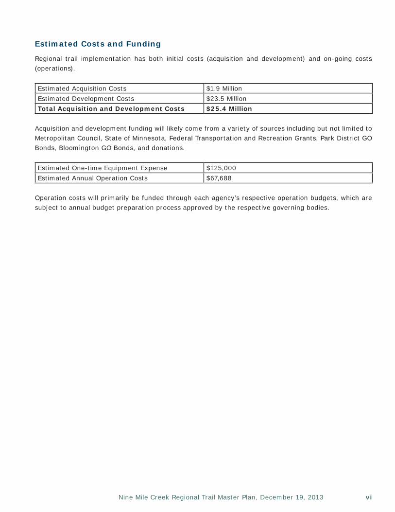
Estimated Costs and Funding
Regional trail implementation has both initial costs (acquisition and development) and on-going costs (operations).
Estimated Acquisition Costs $1.9 MillionEstimated Development Costs $23.5 MillionTotal Acquisition and Development Costs $25.4 Million
Acquisition and development funding will likely come from a variety of sources including but not limited to Metropolitan Council, State of Minnesota, Federal Transportation and Recreation Grants, Park District GO Bonds, Bloomington GO Bonds, and donations.
Estimated One-time Equipment Expense $125,000Estimated Annual Operation Costs $67,688
Operation costs will primarily be funded through each agency’s respective operation budgets, which are subject to annual budget preparation process approved by the respective governing bodies.

Three Rivers Park Districtvii
This page left intentionally blank
viiiNine Mile Creek Regional Trail Master Plan, December 19, 2013
Table of ContentsPage
Section I Planning Framework....................................................... 1Overview........................................................................................... 1
Metropolitan Regional Parks System.................................................. 2
Three Rivers Park District.................................................................. 3
Planning Guidelines........................................................................... 4
Section II Planning & Public Process.............................................. 5Planning History................................................................................ 5
Cities of Hopkins and Minnetonka..................................................... 7
City of Edina..................................................................................... 7
City of Richfield................................................................................. 12
City of Bloomington.......................................................................... 12
Final Master Plan Review & Formal Approval Process......................... 13
Section III Demand Forecast............................................................ 15Overview........................................................................................... 15
Recreational Use Trends..................................................................... 15
Existing Park District Regional Trail User Data.................................... 17
Trail Visitor Preferences...................................................................... 18
Projected Trail Use, Visitation, and Demographics.............................. 19
Trail Demographics............................................................................ 20
Section IV Trail Description & Background....................................... 23Overview........................................................................................... 23Hopkins Segment.............................................................................. 27Minnetonka Segment........................................................................ 29Edina Segment................................................................................. 31Richfield Segment............................................................................. 37Bloomington Segment..................................................................... 39
Three Rivers Park Districtix
Section VI Operations Plan.............................................................. 63Park District Operation Plan............................................................... 63
Bloomington Operation Plan.............................................................. 67
Section VII Estimated Costs & Funding Sources................................ 69Acquisition and Development............................................................. 69
Operation.......................................................................................... 69
Appendix A Resolutions of Support.................................................. 71
Appendix B Nine Mile Creek Trail Status and Implementation Plan... 79
Appendix C MLCCS Map.................................................................... 81
Appendix D Cost Estimate................................................................. 83
Section V Design and Implementation............................................ 41Typical Design................................................................................... 41Route Assessment............................................................................ 48Planned Nine Mile Creek Regional Trail Segments.............................. 49Implementation................................................................................ 60
1Nine Mile Creek Regional Trail Master Plan, December 19, 2013
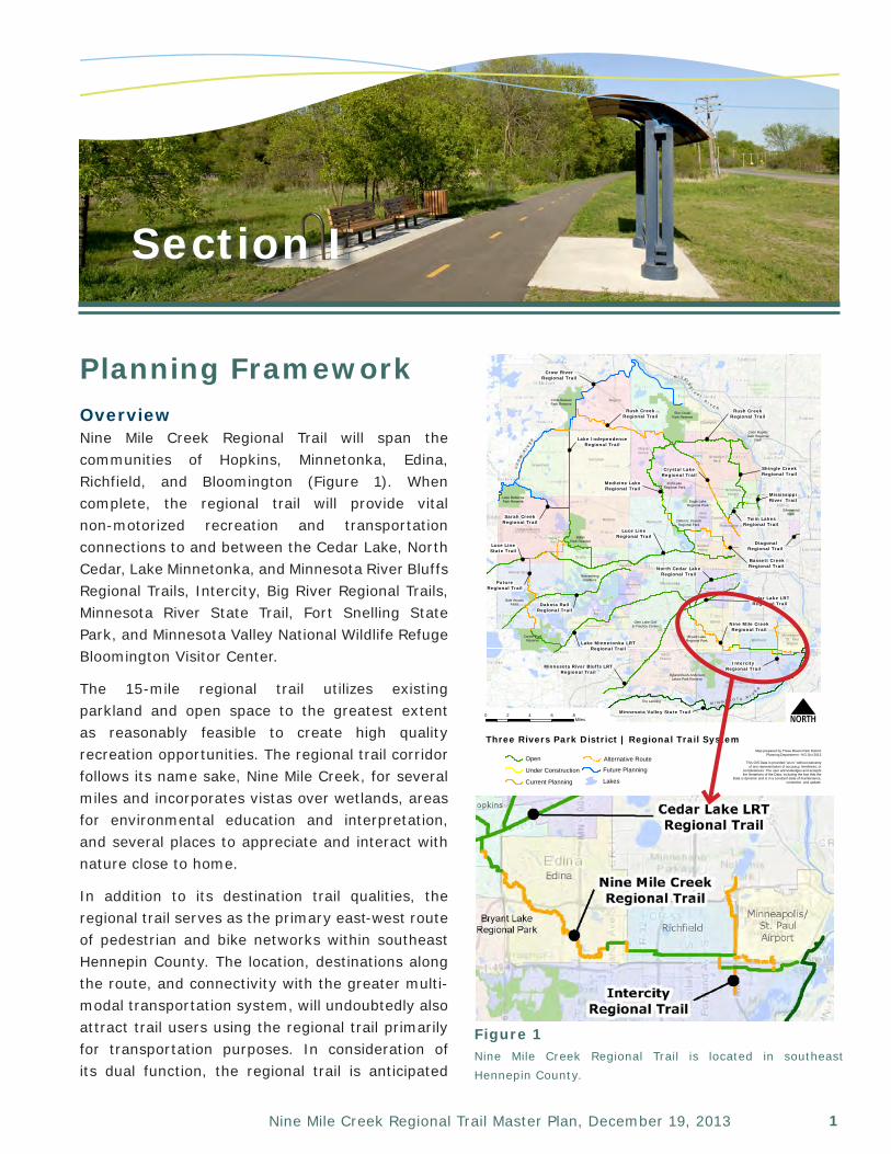
Planning FrameworkOverviewNine Mile Creek Regional Trail will span the communities of Hopkins, Minnetonka, Edina, Richfield, and Bloomington (Figure 1). When complete, the regional trail will provide vital non-motorized recreation and transportation connections to and between the Cedar Lake, North Cedar, Lake Minnetonka, and Minnesota River Bluffs Regional Trails, Intercity, Big River Regional Trails, Minnesota River State Trail, Fort Snelling State Park, and Minnesota Valley National Wildlife Refuge Bloomington Visitor Center.
The 15-mile regional trail utilizes existing parkland and open space to the greatest extent as reasonably feasible to create high quality recreation opportunities. The regional trail corridor follows its name sake, Nine Mile Creek, for several miles and incorporates vistas over wetlands, areas for environmental education and interpretation, and several places to appreciate and interact with nature close to home.
In addition to its destination trail qualities, the regional trail serves as the primary east-west route of pedestrian and bike networks within southeast Hennepin County. The location, destinations along the route, and connectivity with the greater multi-modal transportation system, will undoubtedly also attract trail users using the regional trail primarily for transportation purposes. In consideration of its dual function, the regional trail is anticipated
Section I
Figure 1Nine Mile Creek Regional Trail is located in southeast Hennepin County.
Crow-HassanPark Reserve
Lake RebeccaPark Reserve
BakerPark Reserve
Carver ParkReserve
NoerenbergGardens
Hyland-Bush-AndersonLakes Park Reserve
Bryant LakeRegional Park
Glen Lake Golf& Practice Center
Cleary LakeRegional Park
Murphy-HanrehanPark Reserve
SilverwoodPark
Coon RapidsDam Regional
Park
Elm CreekPark Reserve
Eagle LakeRegional Park
Clifton E. FrenchRegional Park
Fish LakeRegional Park
Lake Minnetonka LRTRegional Trail
Minnesota River Bluffs LRTRegional Trail
Cedar Lake LRTRegional Trail
North Cedar LakeRegional Trail
Dakota RailRegional Trail
Sarah CreekRegional Trail
Crow RiverRegional Trail
Lake IndependenceRegional Trail
Medicine LakeRegional Trail
Rush CreekRegional Trail
Crystal LakeRegional Trail
Shingle CreekRegional Trail
Luce LineRegional Trail
Bassett CreekRegional Trail
Twin LakesRegional Trail
DiagonalRegional Trail
GreenfieldCorcoran
MapleGrove
MedinaPlymouth
Rogers
Dayton
Champlin
BrooklynPark
Osseo
BrooklynCenter
NewHope Crystal
Robbinsdale
GoldenValley
MinnetonkaSt. Louis
Park
EdenPrairie
Edina
Hopkins
Bloomington
RichfieldMinneapolis/
St. PaulAirport
Minnetrista
Independence
Orono
Wayzata
Woodland
Deephaven
Greenwood
TonkaBay
Shorewood Nine Mile CreekRegional Trail
IntercityRegional Trail
Gale WoodsFarm
Luce LineState Trail
Minnesota Valley State Trail
FutureRegional Trail
Maple Plain
MississippiRiver Trail
The Landing
M I S S I SS
I
P P IR I V E R
M I N N E S O T A R I V
E
R
CR
OW
RI V
ER
Rush CreekRegional Trail
Sources: Esri, DeLorme, NAVTEQ, TomTom, Intermap, increment P Corp.,GEBCO, USGS, FAO, NPS, NRCAN, GeoBase, IGN, Kadaster NL, OrdnanceSurvey, Esri Japan, METI, Esri China (Hong Kong), swisstopo, and the GIS UserCommunity
0 2 4 6 8Miles N
Three Rivers Park District | Regional Trail System
Open
Under Construction
Current Planning
Alternative Route
Future Planning
Lakes
Map prepared by Three Rivers Park DistrictPlanning Department - KG Oct 2013
This GIS Data is provided "as is" without warrantyof any representation of accuracy, timeliness, or
completeness. The user acknowledges and acceptsthe limitations of the Data, including the fact that the
Data is dynamic and is in a constant state of maintenance,correction, and update.
Three Rivers Park District2
Section 1 | Planning Framework
to generate 426,000 annual visits, making it a critical component of Three Rivers Park District’s (Park District) Regional Park and Trail System.
This section of the Master Plan identifies how the Nine Mile Creek Regional Trail fits into the plans, policies, and goals of the agencies which provide oversight, funding, and/or operations and maintenance resources.
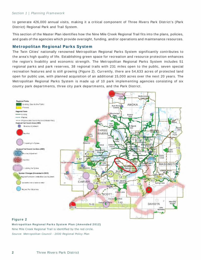
Metropolitan Regional Parks SystemThe Twin Cities’ nationally renowned Metropolitan Regional Parks System significantly contributes to the area’s high quality of life. Establishing green space for recreation and resource protection enhances the region’s livability and economic strength. The Metropolitan Regional Parks System includes 51 regional parks and park reserves, 38 regional trails with 231 miles open to the public, seven special recreation features and is still growing (Figure 2). Currently, there are 54,633 acres of protected land open for public use, with planned acquisition of an additional 15,000 acres over the next 20 years. The Metropolitan Regional Parks System is made up of 10 park implementing agencies consisting of six county park departments, three city park departments, and the Park District.
Figure 2Metropolitan Regional Parks System Plan (Amended 2012)
Nine Mile Creek Regional Trail is identified by the red circle.
Source: Metropolitan Council - 2030 Regional Policy Plan
3Nine Mile Creek Regional Trail Master Plan, December 19, 2013
Section 1 | Planning Framework
The Metropolitan Council is the regional planning agency that oversees and provides partial funding of the acquisition, development, and operation of regional parks and trail system. The Metropolitan Council and implementing agencies also develop regional park policies to protect the region’s water quality; promote best management practices; and help integrate the parks system with housing, transportation, and other regional priorities.
The Metropolitan Council provides guidance in the development of regional park and trail master plans. The Nine Mile Creek Regional Trail Master Plan reflects that guidance. Each regional park or trail must have a master plan approved by the Metropolitan Council prior to receiving Metropolitan Council funding. The master plan must address boundaries and acquisition, demand, development concept, implementation schedule, development and operational costs, and natural resources. Public input is encouraged throughout the master planning process. The Metropolitan Council’s planning requirements help ensure consistency between the implementing agencies’ and their own regional plans.
Three Rivers Park DistrictThe Park District is an independent, special park district charged with the responsibilities of acquisition, development, and maintenance of regional park reserves, parks, special recreation features, and trails for the benefit and use of the citizens of suburban Hennepin County, the seven-county Twin Cities metropolitan area, and the State of Minnesota. The Park District works cooperatively with local communities, counties, public agencies, Metropolitan Council, and State Legislature.
The Park District’s mission is to promote environmental stewardship through recreation and education in a natural resources-based park system. The Park District was established in 1957 by the Minnesota State Legislature when prominent members of the community promoted the benefits of parks in the outlying areas of Hennepin County. Since its conception, the Park District has grown
to serve over 9.3 million annual visitors through access to 26,500 acres of park reserves, regional parks, special recreation features, and 120 miles of regional trails. Many of these parklands and regional trails are located in second- and third-tier communities, where acquisition of parks and trails was historically more economically and politically feasible.
To better serve the residents within the first-tier communities surrounding Minneapolis and the population center of Hennepin County, the Park District is working on the expansion of the regional trail system, including Nine Mile Creek Regional Trail. Realization of this goal will bring regional recreational opportunities to nine first–tier communities, several of which are otherwise underserved by the Park District’s network of parks and trails.
BloomingtonBloomington is one of the premier parks and recreation systems in Minnesota with nearly a third of the city comprised of parks, open space, wetlands or lakes. As one of the 10 park implementing agencies of the Metropolitan Regional Parks System, Bloomington jointly operates the Hyland-Bush-Anderson Lakes Park Reserve and the planned Intercity Regional Trail with the Park District. This partnership will be enhanced as both agencies will also play a key role in designing, implementing, and operating the Nine Mile Creek Regional Trail segments in Bloomington. Bloomington also owns and operates local park and trail facilities and is home to the Minnesota Valley National Wildlife Refuge.
To better serve its residents, Bloomington adopted an Alternative Transportation Plan (ATP) in July 2008. The Bloomington Comprehensive Plan and Imagine Bloomington 2025 calls for the implementation of the ATP and, more specifically, the creation of bikeway and walkway networks linking to and between transit and various commercial and recreational destinations. The ATP’s primary goal is the development of a comprehensive system for inter- and intra-city travel. The purpose of the
Three Rivers Park District4
Section 1 | Planning Framework
plan is to enhance the quality of life in Bloomington through strategic investments in multi-modal transportation features that meet the needs of individuals and families living, working and recreating in Bloomington.
Bloomington recently underwent extensive planning for the South Loop District bound by, I-494 on the north, TH 77 on the west, and the Minnesota River on the south and east. The South Loop District Plan will guide future land use, transportation, urban design, and redevelopment of this important commercial and employment center. One objective of the plan is to establish a distinct mixed-use district that takes advantage of South Loop’s unique location adjacent to the 12th-busiest airport in the United States, the Mall of America, and a National Wildlife Refuge.
The route for Nine Mile Creek Regional Trail is identified in the ATP as an enhanced pedestrian way and in the South Loop District as a regional trail.
Regional Trail Planning GuidelinesRegional trail corridors, such as the Nine Mile Creek Regional Trail, are intended to provide recreational travel along linear pathways that transcend multiple jurisdictions and may or may not also serve a transportation component. In addition, regional trails follow criteria established by the Metropolitan Council and Park District:
• Regional trail corridors are carefully selected to follow natural or cultural linear features with scenic appeal and/or historical, architectural and developmental interest, connect people with places, help create a sense of place amongst the greater community, intersect with local trail, sidewalk, and bicycle networks, provide access to mass transit, and link components of the regional park system together.
• Regional trails may function as a destination or linking regional trail or both:
o Destination regional trails are developed as greenways or linear parks, and distinct in that the trail itself is a destination. This type
of regional trail typically is an independent facility and includes a wide corridor providing opportunities for improving wildlife habitat, protecting natural/cultural resources, and providing recreational opportunities.
o Linking regional trails serve a greater transportation function and act as the backbone to the regional trail system by connecting the regional park system to itself and the people it serves in a logical and efficient manner.
• For either regional trail type, adjacent land with significant natural or cultural resources may be acquired as part of the trail corridor.
Nine Mile Creek Regional Trail will serve as both a destination and linking function; however, its primary function is providing opportunities for high-quality recreational experiences and is, therefore, classified as a destination regional trail.
5Nine Mile Creek Regional Trail Master Plan, December 19, 2013
Section II
Planning & Public ProcessThe Park District conducted an extensive planning and public engagement process for Nine Mile Creek Regional Trail.
As part of the planning process, the Park District worked off the success of many existing planning efforts, collaborated closely with stakeholders, and utilized a variety of public outreach and engagement techniques.
Related Projects and PlanningA number of other recently completed and concurrent efforts that complement the Nine Mile Creek Regional Trail planning and implementation processes provided guidance or otherwise influenced the outcome of this master plan.
Planning Documents and StudiesWithin each of the plans listed below, the intent of the regional trail is apparent; however, the identified route may be slightly different than what is designated as part of this master plan in response to a detailed analysis and public engagement efforts of the master planning process.
• 2030 Comprehensive Plans – Cities of Hopkins, Minnetonka, Edina, Richfield, and Bloomington
• 1997 Hennepin County Bicycle Plan and Biannual Map Updates
• 2007 City of Edina Comprehensive Bicycle Plan
• 2006 City of Edina Recreation Needs Assessment
• 2008 City of Bloomington Alternative Transportation Plan
• 2012 City of Bloomington South Loop District Plan
Trail Construction Initiatives• 2012 - Nine Mile Creek Restoration and
Regional Trail Construction from 9th Avenue in Hopkins to TH 169 in Minnetonka
• 2012 – Gallagher Drive Reconstruction and Regional Trail Construction from Parklawn Avenue to France Avenue in Edina
• 2010-2012 – Metropolitan Council Environmental Services Sewer Extension and Regional Trail Construction from Xerxes Avenue to 12th Avenue in Richfield
• 2012 - 76th Street Reconstruction and Regional Trail Construction from 12th Avenue to Cedar Avenue in Richfield
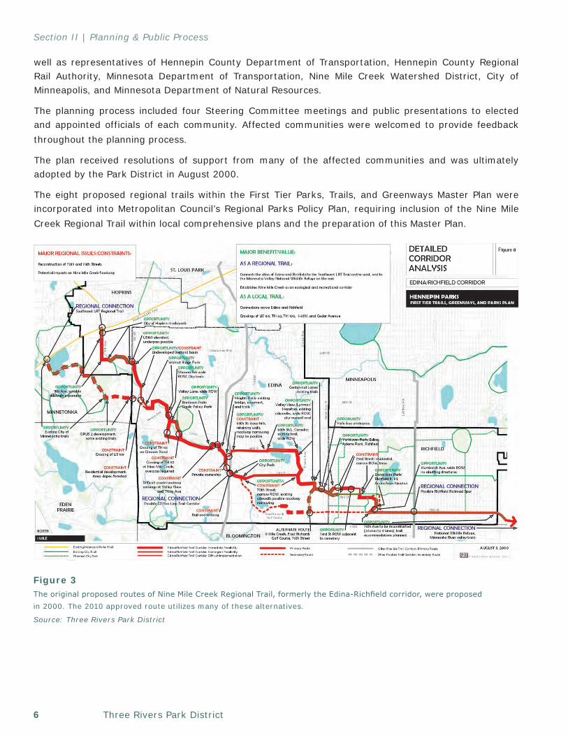
Planning History - 2000 First Tier Parks, Trails, and Greenways Master PlanNine Mile Creek Regional Trail was first envisioned and planned in 2000 as the Edina-Richfield corridor; part of a larger initiative to provide regional recreation opportunities in the first-tier communities of Minneapolis (Figure 3). The planning process for the First Tier Parks, Trails, and Greenways Master Plan utilized a Steering Committee comprised of representatives from the affected communities as
Three Rivers Park District6
Section II | Planning & Public Process
well as representatives of Hennepin County Department of Transportation, Hennepin County Regional Rail Authority, Minnesota Department of Transportation, Nine Mile Creek Watershed District, City of Minneapolis, and Minnesota Department of Natural Resources.
The planning process included four Steering Committee meetings and public presentations to elected and appointed officials of each community. Affected communities were welcomed to provide feedback throughout the planning process.
The plan received resolutions of support from many of the affected communities and was ultimately adopted by the Park District in August 2000.
The eight proposed regional trails within the First Tier Parks, Trails, and Greenways Master Plan were incorporated into Metropolitan Council’s Regional Parks Policy Plan, requiring inclusion of the Nine Mile Creek Regional Trail within local comprehensive plans and the preparation of this Master Plan.
Figure 3The original proposed routes of Nine Mile Creek Regional Trail, formerly the Edina-Richfield corridor, were proposed in 2000. The 2010 approved route utilizes many of these alternatives.
Source: Three Rivers Park District

7Nine Mile Creek Regional Trail Master Plan, December 19, 2013
Section II | Planning & Public Process
Cities of Hopkins and MinnetonkaThe First Tier Parks, Trails, and Greenways Master Plan included two potential Nine Mile Creek Regional Trail routes through Hopkins and Minnetonka. Upon additional evaluation and in combination with an opportunity to construct portions of the regional trail with a creek restoration project, Hopkins, Minnetonka, and the Park District elected to move forward with the originally preferred northern route predominantly located within Hopkins.
Hopkins, Nine Mile Creek Watershed District, and the Park District held several public meetings for the creek restoration initiative and associated trail proposal. With the assistance of the Park District, individual stakeholder meetings were held to solidify the route where significant private property impacts were anticipated. As a part of these meetings, information pertaining to the regional trail route, anticipated use, maintenance, operation, and funding responsibilities, and general regional trail background was available for public review and comment.
The public engagement process resulted in one minor route adjustment to relocate the proposed route from private property along Nine Mile Creek to the existing 7th Street and 9th Avenue right-of-ways in Hopkins.
Hopkins, Minnetonka, Nine Mile Creek Watershed District, and the Park District entered into a four-party agreement in February 2012 establishing the preferred regional trail route and formally
designating the planning, design, construction, and operation and maintenance responsibilities for Nine Mile Creek Regional Trail.
City of EdinaThe 2000 First Tier Parks, Trails, and Greenways Master Plan included several different routes through Edina. In an effort to identify one preferred route, the Park District and Edina collaborated in an extensive public engagement process from 2008 to 2010.
Fall 2008 - Winter 2008: Staff ReviewEdina and Park District staff reviewed previous Nine Mile Creek Regional Trail studies and compiled all proposed routes for additional review and consideration.
December 2008: Informal Open HouseEdina and Park District staff held an informal open house for the Bike Edina Task Force in December 2008. The open house provided an opportunity to share previous planning efforts with the Task Force and obtain Task Force feedback regarding the Task Force’s goals, priorities, and insight to the various routes. Task Force members were encouraged to place Post-it notes with their comments directly on the presentation boards.
No significant changes to the proposed routes were made as a result of this meeting.
Spring 2009: Open HousesEdina and the Park District hosted two open houses on Wednesday, February 11, 2009 and on
Throughout the route selection process, Edina and the Park District hosted several highly-attended open houses.
Three Rivers Park District8
Section II | Planning & Public Process
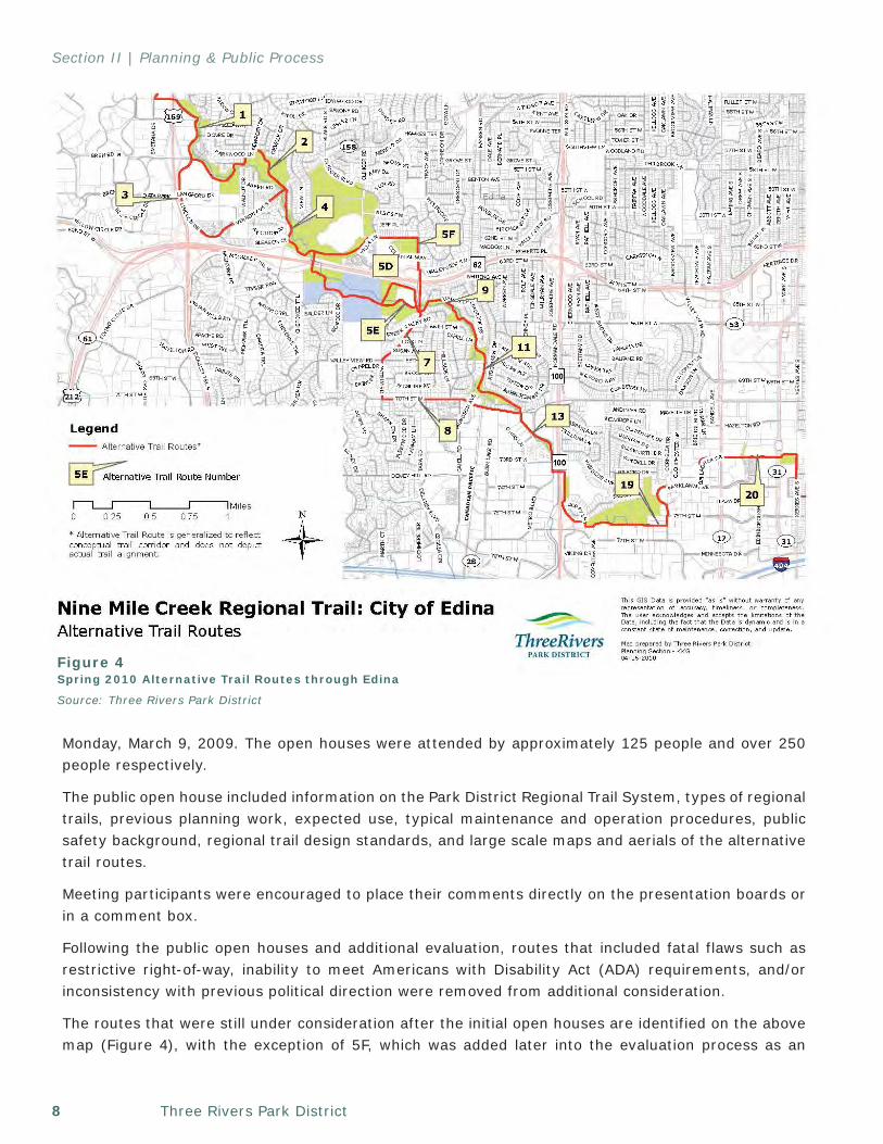
Figure 4Spring 2010 Alternative Trail Routes through Edina
Source: Three Rivers Park District
Monday, March 9, 2009. The open houses were attended by approximately 125 people and over 250 people respectively.
The public open house included information on the Park District Regional Trail System, types of regional trails, previous planning work, expected use, typical maintenance and operation procedures, public safety background, regional trail design standards, and large scale maps and aerials of the alternative trail routes.
Meeting participants were encouraged to place their comments directly on the presentation boards or in a comment box.
Following the public open houses and additional evaluation, routes that included fatal flaws such as restrictive right-of-way, inability to meet Americans with Disability Act (ADA) requirements, and/or inconsistency with previous political direction were removed from additional consideration.
The routes that were still under consideration after the initial open houses are identified on the above map (Figure 4), with the exception of 5F, which was added later into the evaluation process as an
9Nine Mile Creek Regional Trail Master Plan, December 19, 2013
Section II | Planning & Public Process
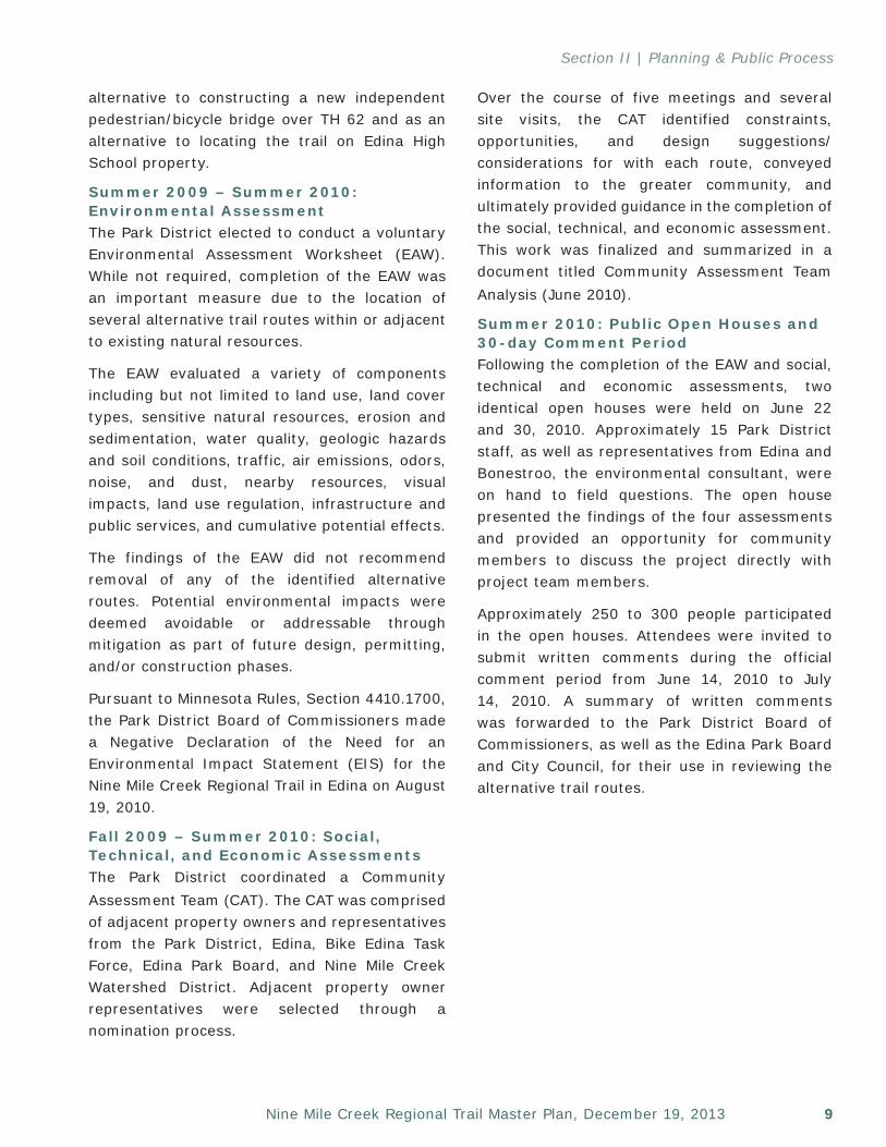
Over the course of five meetings and several site visits, the CAT identified constraints, opportunities, and design suggestions/considerations for with each route, conveyed information to the greater community, and ultimately provided guidance in the completion of the social, technical, and economic assessment. This work was finalized and summarized in a document titled Community Assessment Team Analysis (June 2010).
Summer 2010: Public Open Houses and 30-day Comment PeriodFollowing the completion of the EAW and social, technical and economic assessments, two identical open houses were held on June 22 and 30, 2010. Approximately 15 Park District staff, as well as representatives from Edina and Bonestroo, the environmental consultant, were on hand to field questions. The open house presented the findings of the four assessments and provided an opportunity for community members to discuss the project directly with project team members.
Approximately 250 to 300 people participated in the open houses. Attendees were invited to submit written comments during the official comment period from June 14, 2010 to July 14, 2010. A summary of written comments was forwarded to the Park District Board of Commissioners, as well as the Edina Park Board and City Council, for their use in reviewing the alternative trail routes.
alternative to constructing a new independent pedestrian/bicycle bridge over TH 62 and as an alternative to locating the trail on Edina High School property.
Summer 2009 – Summer 2010: Environmental AssessmentThe Park District elected to conduct a voluntary Environmental Assessment Worksheet (EAW). While not required, completion of the EAW was an important measure due to the location of several alternative trail routes within or adjacent to existing natural resources.
The EAW evaluated a variety of components including but not limited to land use, land cover types, sensitive natural resources, erosion and sedimentation, water quality, geologic hazards and soil conditions, traffic, air emissions, odors, noise, and dust, nearby resources, visual impacts, land use regulation, infrastructure and public services, and cumulative potential effects.
The findings of the EAW did not recommend removal of any of the identified alternative routes. Potential environmental impacts were deemed avoidable or addressable through mitigation as part of future design, permitting, and/or construction phases.
Pursuant to Minnesota Rules, Section 4410.1700, the Park District Board of Commissioners made a Negative Declaration of the Need for an Environmental Impact Statement (EIS) for the Nine Mile Creek Regional Trail in Edina on August 19, 2010.
Fall 2009 – Summer 2010: Social, Technical, and Economic AssessmentsThe Park District coordinated a Community Assessment Team (CAT). The CAT was comprised of adjacent property owners and representatives from the Park District, Edina, Bike Edina Task Force, Edina Park Board, and Nine Mile Creek Watershed District. Adjacent property owner representatives were selected through a nomination process.
Three Rivers Park District10
Section II | Planning & Public Process
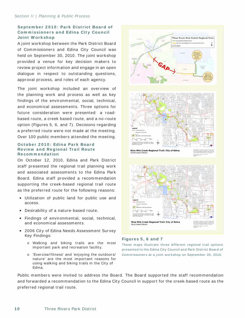
Figures 5, 6 and 7These maps illustrate three different regional trail options presented to the Edina City Council and Park District Board of Commissioners at a joint workshop on September 30, 2010.
September 2010: Park District Board of Commissioners and Edina City Council Joint Workshop A joint workshop between the Park District Board of Commissioners and Edina City Council was held on September 30, 2010. The joint workshop provided a venue for key decision makers to review project information and engage in an open dialogue in respect to outstanding questions, approval process, and roles of each agency.
The joint workshop included an overview of the planning work and process as well as key findings of the environmental, social, technical, and economical assessments. Three options for future consideration were presented: a road-based route, a creek based route, and a no-route option (Figures 5, 6, and 7). Decisions regarding a preferred route were not made at the meeting. Over 100 public members attended the meeting.
October 2010: Edina Park Board Review and Regional Trail Route RecommendationOn October 12, 2010, Edina and Park District staff presented the regional trail planning work and associated assessments to the Edina Park Board. Edina staff provided a recommendation supporting the creek-based regional trail route as the preferred route for the following reasons:
• Utilization of public land for public use and access.
• Desirability of a nature-based route.
• Findings of environmental, social, technical, and economical assessments.
• 2006 City of Edina Needs Assessment Survey Key Findings:
o Walking and biking trails are the most important park and recreation facility.
o ‘Exercise/fitness’ and ‘enjoying the outdoors/nature’ are the most important reasons for using walking and biking trails in the City of
Edina.
Public members were invited to address the Board. The Board supported the staff recommendation and forwarded a recommendation to the Edina City Council in support for the creek-based route as the preferred regional trail route.
11Nine Mile Creek Regional Trail Master Plan, December 19, 2013
Section II | Planning & Public Process
December 2010: City Council Review and Approve Regional Trail Route The Edina City Council held a public hearing on December 7, 2010, regarding the regional trail. The meeting was highly attended and included testimony of over 50 citizens. Edina and Park District staff representatives were available to answer questions.
The Edina City Council unanimously approved the creek-based Nine Mile Creek Regional Trail route as the preferred regional trail route with the following restrictions and conditions:
1. Keep the trail on the south side of Walnut Ridge Park.
2. That Three Rivers Park District makes all reasonable efforts in the engineering/design phase to minimize boardwalk noise and height.
3. That Three Rivers Park District offer to provide homeowners with principal residences adjacent to the proposed regional trail edge the option to have buffers where reasonable and at Three River’s expense. Buffer options are fencing or vegetative screening (trees, shrubs).
4. That Three Rivers Park District take reasonable steps to minimize the amount of boardwalks in the complex balancing act that also attempts to minimize the impact on the environment (wetlands, water quality, and vegetation).
5. Place a time limit deadline on the easements offered to Three Rivers Park District to complete the project within a reasonable time frame. A reasonable time limit should be negotiated with Three Rivers Park District and that language should be included in the easement agreement.
6. That the final design shall minimize property impacts and be subject to Council approval.
7. That a reasonable sound wall be constructed for Segment 19 that was satisfactory to the City.
March 2011: Park District Board of Commissioners Approve Regional Trail RouteOn March 17, 2011, the Park District Board of Commissioners approved the creek-based Nine Mile Creek Regional Trail route as the preferred regional trail route through Edina. The meeting was open to the public; however, no public members attended or provided comments.
The route through Edina approved by the Edina City Council and the Park District Board of Commissioners is the route shown in this master plan.
August 2012: Regional Trail Cooperative AgreementIn August 2012, the Park District and Edina entered into a regional trail cooperative agreement for the regional trail segment located between Fred Richards Golf Course and Edina’s eastern border. This agreement designates the planning, design, construction, and operations and maintenance responsibilities for this segment of the regional trail. It is anticipated that this agreement will be amended or a supplemental agreement will be established over the course of the next year to define these same responsibilities for the remaining trail segments.
Three Rivers Park District12
Section II | Planning & Public Process
City of RichfieldThe regional trail route through Richfield was solidified as part of a larger initiative to extend and upgrade a regional sewer interceptor. This initiative created a significant opportunity to coordinate sewer interceptor construction, 75th and 76th Streets reconstruction, and regional trail construction between Xerxes and 12th Avenues.
Regional trail project information was available for public review at several public meetings including, but not limited to, the Metropolitan Council Environmental Services Sewer Interceptor open house on January 15, 2009, and a Richfield Parkway open house on June 24, 2009.
Upon completion of the trail segment west of 12th Avenue, Richfield elected to carry the same right-of-way design east to Cedar Avenue in 2012.
Richfield and the Park District entered into two regional trail cooperative agreements; one for the trail segment west of 12th Avenue in February 2010, and one for the trail segment east of 12th Avenue in September 2012. The regional trail cooperative agreements formally designated the planning, design, construction, and operation and maintenance responsibilities for Nine Mile Creek Regional Trail.
City of BloomingtonThe Nine Mile Creek Regional Trail segment in the City of Bloomington is generally consistent with the City’s 2008 Alternative Transportation Plan (ATP) and 2012 South Loop District Plan. As part of the ATP and South Loop District planning processes, Bloomington conducted a variety of public participation opportunities including on-line surveys, open houses, stakeholder interviews, and public presentations. Due to the amount of existing planning efforts and public engagement opportunities for this area, no additional public open houses or meetings specific to the regional trail were held.
Implementation of this segment is contingent on the ability to secure required right-of-way and reconstructing existing sidewalk and trail facilities to regional trail standards. If it is not reasonably feasible to secure right-of-way or improve this trail segment as opportunities arise, an alternative route is proposed north of I-494. This route passes under TH 77 and through the Metropolitan Airport Commission property adjacent to the airport.
13Nine Mile Creek Regional Trail Master Plan, December 19, 2013
Section II | Planning & Public Process
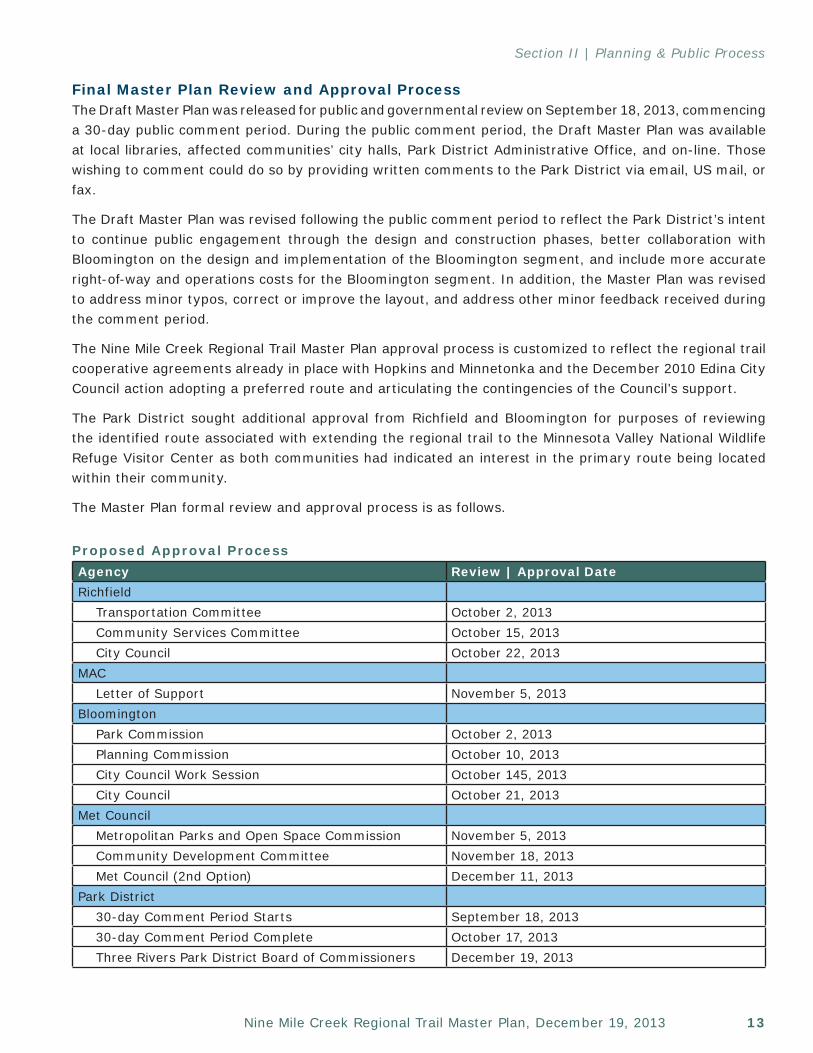
Final Master Plan Review and Approval ProcessThe Draft Master Plan was released for public and governmental review on September 18, 2013, commencing a 30-day public comment period. During the public comment period, the Draft Master Plan was available at local libraries, affected communities’ city halls, Park District Administrative Office, and on-line. Those wishing to comment could do so by providing written comments to the Park District via email, US mail, or fax.
The Draft Master Plan was revised following the public comment period to reflect the Park District’s intent to continue public engagement through the design and construction phases, better collaboration with Bloomington on the design and implementation of the Bloomington segment, and include more accurate right-of-way and operations costs for the Bloomington segment. In addition, the Master Plan was revised to address minor typos, correct or improve the layout, and address other minor feedback received during the comment period.
The Nine Mile Creek Regional Trail Master Plan approval process is customized to reflect the regional trail cooperative agreements already in place with Hopkins and Minnetonka and the December 2010 Edina City Council action adopting a preferred route and articulating the contingencies of the Council’s support.
The Park District sought additional approval from Richfield and Bloomington for purposes of reviewing the identified route associated with extending the regional trail to the Minnesota Valley National Wildlife Refuge Visitor Center as both communities had indicated an interest in the primary route being located within their community.
The Master Plan formal review and approval process is as follows.
Proposed Approval ProcessAgency Review | Approval DateRichfield
Transportation Committee October 2, 2013Community Services Committee October 15, 2013City Council October 22, 2013
MACLetter of Support November 5, 2013
BloomingtonPark Commission October 2, 2013Planning Commission October 10, 2013City Council Work Session October 145, 2013City Council October 21, 2013
Met CouncilMetropolitan Parks and Open Space Commission November 5, 2013Community Development Committee November 18, 2013Met Council (2nd Option) December 11, 2013
Park District30-day Comment Period Starts September 18, 201330-day Comment Period Complete October 17, 2013Three Rivers Park District Board of Commissioners December 19, 2013

Three Rivers Park District14
Section II | Planning & Public Process
Future Public EngagementThe Park District will continue to engage the public through the design and construction phases of Nine Mile Creek Regional Trail. While the public engagement process for these phases has not yet been defined, the intent is to engage the public early and often and to balance engagement efforts between those most affected by the trail with the greater community and trail users.
15Nine Mile Creek Regional Trail Master Plan, December 19, 2013
Section III
Demand ForecastOverviewNine Mile Creek Regional Trail is anticipated to become a significant regional trail destination due to its connectivity with existing and future regional trails as well as local parks, trails, schools, churches, retail nodes, commercial areas, and employment centers, its proximity to the undeveloped Nine Mile Creek corridor, and it’s role as the only east-west contiguous and continuous designated bike/walk corridor stretching across five communities in southeast Hennepin County. In addition, the communities in which the regional trail is located are fully developed. As such, Nine Mile Creek Regional Trail will serve a large population base – many of which do not currently have access to the regional trail system.
Recreational Use TrendsNational, state, regional, and Park District recreational use trend studies support continued expansion, improvement, and implementation of trails. Recreational studies also indicate that of the wide varieties of recreation activities, trails appear to be the common thread across most demographics groups.
National Trends National recreation trends compiled within the Outdoor Recreation Participation Report: Topline 2013 by the Outdoor Foundation indicate a clear increase in participation since 2006 in several regional trail activities for persons over 6 years old: biking (road/paved surface) 2 percent increase; day hiking 16 percent increase; running/jogging 35 percent increase; and trail running 32 percent increase. This same study found that running, jogging, and trail running is the second most popular adult activity with 14.9 percent of adults participating (30.8 million participants);
bicycling is the third most popular adult activity with 12 percent of adults participating (24.8 million participants); and hiking is the fourth most popular adult activity with 11.7 percent adults participating (24.2 million participants).
The Outdoor Foundation found that accessibility is a key factor to getting Americans outside. Not surprisingly, their study found that people with walking (56 percent participation) and biking (58 percent participation) routes close to their home get outside at significantly higher rates than those without (47 percent participation for walking and biking).
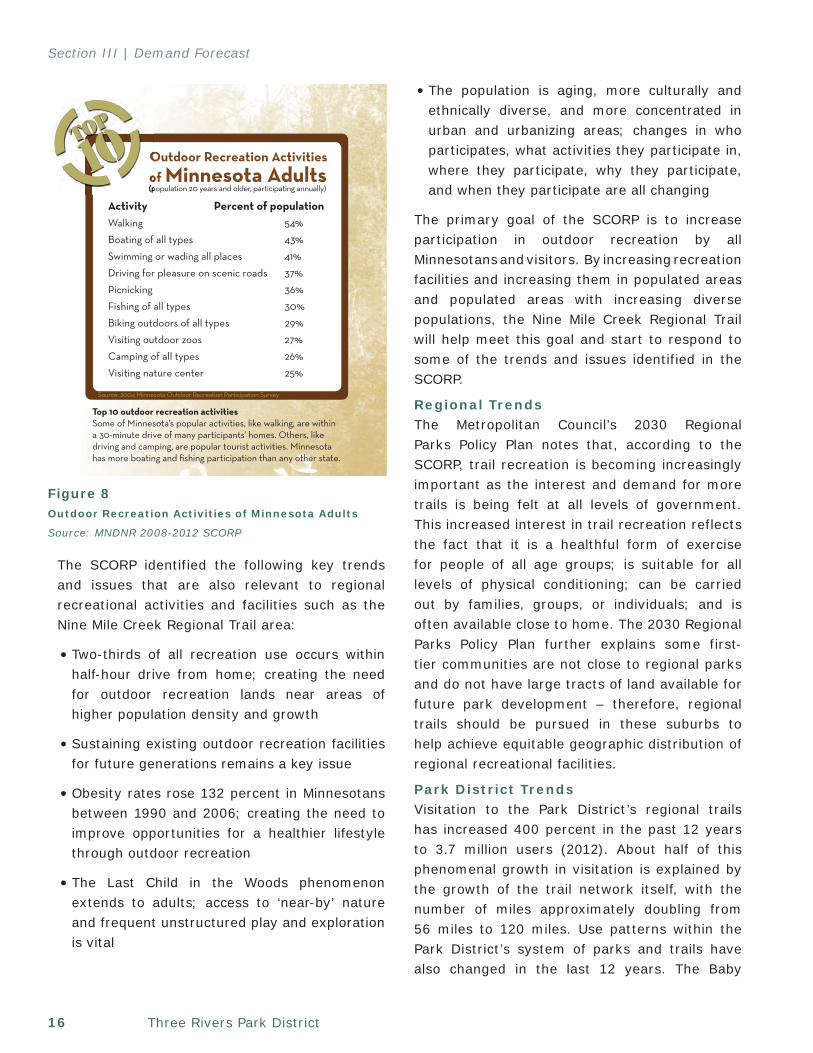
Statewide TrendsThe 2008-2012 State Comprehensive Outdoor Recreation Plan (SCORP), published by Minnesota DNR, denotes that of Minnesota adults, 54 percent participate in walking and 29 percent in biking as recreation activities (Figure 8).
Three Rivers Park District16
Section III | Demand Forecast
The SCORP identified the following key trends and issues that are also relevant to regional recreational activities and facilities such as the Nine Mile Creek Regional Trail area:
• Two-thirds of all recreation use occurs within half-hour drive from home; creating the need for outdoor recreation lands near areas of higher population density and growth
• Sustaining existing outdoor recreation facilities for future generations remains a key issue
• Obesity rates rose 132 percent in Minnesotans between 1990 and 2006; creating the need to improve opportunities for a healthier lifestyle through outdoor recreation
• The Last Child in the Woods phenomenon extends to adults; access to ‘near-by’ nature and frequent unstructured play and exploration is vital
• The population is aging, more culturally and ethnically diverse, and more concentrated in urban and urbanizing areas; changes in who participates, what activities they participate in, where they participate, why they participate, and when they participate are all changing
The primary goal of the SCORP is to increase participation in outdoor recreation by all Minnesotans and visitors. By increasing recreation facilities and increasing them in populated areas and populated areas with increasing diverse populations, the Nine Mile Creek Regional Trail will help meet this goal and start to respond to some of the trends and issues identified in the SCORP.
Regional TrendsThe Metropolitan Council’s 2030 Regional Parks Policy Plan notes that, according to the SCORP, trail recreation is becoming increasingly important as the interest and demand for more trails is being felt at all levels of government. This increased interest in trail recreation reflects the fact that it is a healthful form of exercise for people of all age groups; is suitable for all levels of physical conditioning; can be carried out by families, groups, or individuals; and is often available close to home. The 2030 Regional Parks Policy Plan further explains some first-tier communities are not close to regional parks and do not have large tracts of land available for future park development – therefore, regional trails should be pursued in these suburbs to help achieve equitable geographic distribution of regional recreational facilities.
Park District TrendsVisitation to the Park District’s regional trails has increased 400 percent in the past 12 years to 3.7 million users (2012). About half of this phenomenal growth in visitation is explained by the growth of the trail network itself, with the number of miles approximately doubling from 56 miles to 120 miles. Use patterns within the Park District’s system of parks and trails have also changed in the last 12 years. The Baby
3
SCORP Advisory GroupThis plan was developed with the assistance of an advisory group that in-cluded outdoor recreation and natural resource leaders from local, regional, state and federal government; non-governmental organizations; the recreation industry; and the University of Minnesota. Several of the advisory group’s members also served on the 2003-2008 SCORP advisory group. Staff mem-bers from various divisions and units of the Department of Natural Resources served as either members of the advisory group or as support staff for the SCORP planning effort.
Participants were selected to represent a broad spectrum of outdoor recreation perspectives and experience. Each advisory group member brought a unique viewpoint and experience to the discussion.
The purpose of the advisory group was:
proposed focus of SCORP: decreased outdoor recreation participation and related issues and implications.
The advisory group met several times from March 2007 to September 2007 to review the survey information developed since the last SCORP, discuss and evaluate previous SCORP priorities and recommend new or modified priori-ties, suggest specific recommendations for addressing the priorities and review and comment on drafts.
A list of the advisory group members is included in the appendix.
Top 10 outdoor recreation activitiesSome of Minnesota’s popular activities, like walking, are within a 30-minute drive of many participants’ homes. Others, like driving and camping, are popular tourist activities. Minnesota has more boating and fishing participation than any other state.
Introduction
10TOP
3
Figure 8Outdoor Recreation Activities of Minnesota Adults
Source: MNDNR 2008-2012 SCORP
17Nine Mile Creek Regional Trail Master Plan, December 19, 2013
Section III | Demand Forecast
Boomers who used to bring their kids to Park District parks are now empty-nesters, and they have flocked to the regional trails to get exercise and to get outdoors. Biking, as an alternative form of transportation, has gained traction over the past five years throughout the metro region and more users are now bike commuting. The Park District’s work with local communities and Hennepin County has resulted in a regional trail network that is better connected to the local “feeder” trail, sidewalk, and bike lane networks, making the system more accessible to a larger portion of the population.
In 2011, the Cedar Lake LRT Regional Trail surpassed 500,000 visits (followed closely by North Cedar Lake Regional Trail at 496,000 annual visits) - marking the first time in the Park District’s history that a regional trail received a half a million visits and making visitation comparable to French Regional Park. Of the 13 Park District regional trails open in 2011, eight received 300,000 or more visits. For comparison purposes, six of the 20 parks and reserves received 300,000 or more visits.
As of 2012, regional trail visits accounted for about 40 percent of all visits to the Park District’s facilities. Trail visitation is expected to continue to increase at a rate greater than the expected increase in population, and to increase at a rate faster than expected visitation increases to the Park District’s park units.
Demographic Trends
Aging Baby Boomer GenerationThe baby boomer generation is one of the Park District’s primary user groups. The U.S. Census Bureau considers a baby boomer to be someone born during the demographic birth boom between 1946 and 1964 following World War II. The recreational preferences and habits for this group are well established and demand for their preferred activities will continue to be strong. However, as this group ages, physical limitations will require some park and trail visitors to change
their recreational activities from higher intensity activities such as running, in-line skating, and biking to lower-impact recreational activities such as walking, nature observation, and educational opportunities. Many of these activities are accommodated by the regional trail system.
As this generation ages, trail use over time may initially decrease and then increase when the housing stock turns over to younger families with children.
Immigrant GroupsMetropolitan Council demographers have identified that about half of the total increase in population for the region from 1990 to 2000 was due to immigration of first-generation U.S. citizens and the births of their children. This trend was expected to continue through 2010, if not longer. Within the region, there are three prevalent immigrant groups: Hmong/Southeast Asian, Hispanic/Latino, and Somali/West Africans. To date, this influx of new immigrant groups are generally not participating in regional trail use at the same rates as non-immigrant populations. The Park District is committed to better understanding this phenomenon and will continue to study this further with the ultimate goal of attracting regional trail users which mirror the demographics of the region.
Existing Park District Regional Trail and User Data Regional trails are most heavily visited during the spring, summer, and fall seasons with summer receiving 40 percent of annual visits, spring and fall each receiving 25 percent of annual visits, and winter receiving 10 percent of annual visits. Winter has seen more seasonal growth, in part due to warmer winters, the increased use of trails for commuting, and the use of trails for year-round exercise regimens.
The percent of regional trail activities fluctuates slightly from year to year; however, the trend continues to indicate that biking is, and will remain, the predominant regional trail activity at 76 percent,
Three Rivers Park District18
Section III | Demand Forecast
followed by walking (15 percent), and running (six percent). In-line skating and mobility-device users make up the balance of trail users.
The vast majority of regional trail visitors use trails for recreation and exercise. However, 12 percent of all regional trail visits are now for commuting purposes, up from about 1 percent in 1998. Regional trails that are paved, with few stop conditions, limited interactions with vehicles, and with seamless connections to employment, retail, and commercial centers have a greater percent of regional trail visits attributed to commuting (19-28 percent) than regional trails without these three attributes. While these certainly are not the only factors in determining the desirability of a regional trail corridor for commuting purposes, they appear to play an important role.
The 2008 regional trail survey data indicates that regional trail users are predominantly white (96 percent), male (60 percent), highly educated (76 percent have a bachelor’s degree or higher), married/partnered (77 percent), middle-aged (41 percent are in the 45-59 age group), upper-middle class (43 percent have household incomes over $100,000).
The profile of regional trail visitors does not reflect the demographic mix of suburban Hennepin County. With the exception of premier “destination” trails such as the Dakota Rail Regional Trail, the majority of use comes from people living within three miles of the trail corridor. Consequently, the 2008 demographics are reflective of the communities through which they pass. Several regional trails within the more diverse first-tier communities (Richfield, Bloomington, Edina, New Hope, Crystal, Robbinsdale, Brooklyn Center) are planned for development in the next three years, and the overall trail visitor profile is expected to diversify once those trails are open for use.
Trail Visitor PreferencesBicycle and pedestrian studies from across the country, and over the last twenty-five years, have come to the same general conclusions regarding user preferences - regardless of user type. Trails with these characteristics will attract visitors from greater distances, will have greater annual use, and will produce more enjoyable experiences for trail users:
• Natural settings (scenic, leafy vegetation, limited evidence of the built environment, etc.)• A diversity of natural settings (woodlands, wetlands, prairies, etc.) • Visual and physical separation from vehicles• A continuous and contiguous route with limited stop conditions• A smooth surface (either paved or aggregate)• Connectivity with destinations and other bicycle/pedestrian facilities• Opportunities for loops• Trail amenities - drinking water, mileage markers, restrooms, and wayfinding
Some bicycle and pedestrian studies also indicate that participants are willing to spend more money and travel longer distances to utilize facilities that incorporate these preferences.
In recognition of user preferences, the Nine Mile Creek Regional Trail route was selected to provide linkages to regional recreation destinations; balance recreation and natural resources; minimize stop conditions, provide a safe, off-road, multi-modal transportation option, and ultimately, increase the desirability of the regional trail.
As such, it is reasonable to expect that a regional trail, such as Nine Mile Creek Regional Trail, which incorporates these preferences, will be used more and provide a more enjoyable experience than a regional trail which does not.
19Nine Mile Creek Regional Trail Master Plan, December 19, 2013
Section III | Demand Forecast
Projected Trail Use, Visitation, and DemographicsTrail UseThe percentage breakdown by activity of Nine Mile Creek Regional Trail will generally mirror Park District regional trail trends with the exception that a slightly greater percentage of walking/hiking and a lower percentage of biking are anticipated. This shift is anticipated due to segments of the regional trail playing a role within the greater sidewalk network, complimentary bike lanes facilities in Richfield, and the significant lack of pedestrian/bicycle facilities in other areas. In addition, the regional trail passes through several areas that currently have concentrations of pedestrians and senior citizens (senior citizen’s primary recreation activity is walking). For all of these reasons, it is reasonable to anticipate an increase in the percentage of walking and hiking relative to regional trails without these attributes.
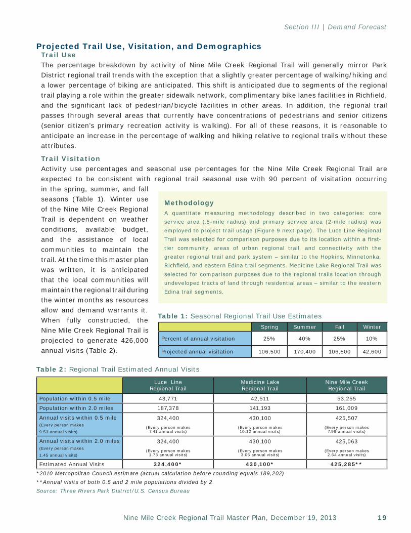
Trail Visitation Activity use percentages and seasonal use percentages for the Nine Mile Creek Regional Trail are expected to be consistent with regional trail seasonal use with 90 percent of visitation occurring in the spring, summer, and fall seasons (Table 1). Winter use of the Nine Mile Creek Regional Trail is dependent on weather conditions, available budget, and the assistance of local communities to maintain the trail. At the time this master plan was written, it is anticipated that the local communities will maintain the regional trail during the winter months as resources allow and demand warrants it. When fully constructed, the Nine Mile Creek Regional Trail is projected to generate 426,000 annual visits (Table 2).
Spring Summer Fall Winter
Percent of annual visitation 25% 40% 25% 10%
Projected annual visitation 106,500 170,400 106,500 42,600
Table 1: Seasonal Regional Trail Use Estimates
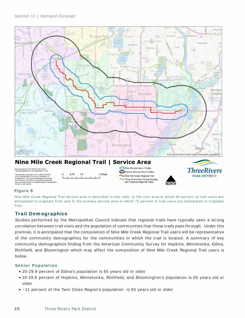
MethodologyA quantitate measuring methodology described in two categories: core service area (.5-mile radius) and primary service area (2-mile radius) was employed to project trail usage (Figure 9 next page). The Luce Line Regional Trail was selected for comparison purposes due to its location within a first-tier community, areas of urban regional trail, and connectivity with the greater regional trail and park system – similar to the Hopkins, Minnetonka, Richfield, and eastern Edina trail segments. Medicine Lake Regional Trail was selected for comparison purposes due to the regional trails location through undeveloped tracts of land through residential areas – similar to the western Edina trail segments.
Luce Line Regional Trail
Medicine Lake Regional Trail
Nine Mile Creek Regional Trail
Population within 0.5 mile 43,771 42,511 53,255
Population within 2.0 miles 187,378 141,193 161,009
Annual visits within 0.5 mile(Every person makes
9.53 annual visits)
324,400(Every person makes
7.41 annual visits)
430,100(Every person makes 10.12 annual visits)
425,507(Every person makes
7.99 annual visits)
Annual visits within 2.0 miles(Every person makes
1.45 annual visits)
324,400(Every person makes
1.73 annual visits)
430,100(Every person makes
3.05 annual visits)
425,063(Every person makes
2.64 annual visits)
Estimated Annual Visits 324,400* 430,100* 425,285***2010 Metropolitan Council estimate (actual calculation before rounding equals 189,202)**Annual visits of both 0.5 and 2 mile populations divided by 2Source: Three Rivers Park District/U.S. Census Bureau
Table 2: Regional Trail Estimated Annual Visits
Three Rivers Park District20
Section III | Demand Forecast
Trail DemographicsStudies performed by the Metropolitan Council indicate that regional trails have typically seen a strong correlation between trail visits and the population of communities that these trails pass through. Under this premise, it is anticipated that the composition of Nine Mile Creek Regional Trail users will be representative of the community demographics for the communities in which the trail is located. A summary of key community demographics finding from the American Community Survey for Hopkins, Minnetonka, Edina, Richfield, and Bloomington which may affect the composition of Nine Mile Creek Regional Trail users is below.
Senior Population• 20-29.9 percent of Edina’s population is 65 years old or older• 10-19.9 percent of Hopkins, Minnetonka, Richfield, and Bloomington’s population is 65 years old or
older• ~11 percent of the Twin Cities Region’s population is 65 years old or older
Figure 9Nine Mile Creek Regional Trail service area is described in two radii; 1) the core area in which 50 percent of trail users are anticipated to originate from and 2) the primary service area in which 75 percent of trail users are anticipated to originate from.
21Nine Mile Creek Regional Trail Master Plan, December 19, 2013
Section III | Demand Forecast
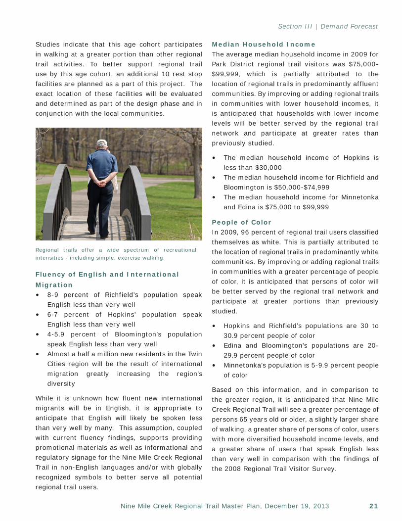
Studies indicate that this age cohort participates in walking at a greater portion than other regional trail activities. To better support regional trail use by this age cohort, an additional 10 rest stop facilities are planned as a part of this project. The exact location of these facilities will be evaluated and determined as part of the design phase and in conjunction with the local communities.
Fluency of English and International Migration • 8-9 percent of Richfield’s population speak
English less than very well• 6-7 percent of Hopkins’ population speak
English less than very well• 4-5.9 percent of Bloomington’s population
speak English less than very well• Almost a half a million new residents in the Twin
Cities region will be the result of international migration greatly increasing the region’s diversity
While it is unknown how fluent new international migrants will be in English, it is appropriate to anticipate that English will likely be spoken less than very well by many. This assumption, coupled with current fluency findings, supports providing promotional materials as well as informational and regulatory signage for the Nine Mile Creek Regional Trail in non-English languages and/or with globally recognized symbols to better serve all potential regional trail users.
Median Household IncomeThe average median household income in 2009 for Park District regional trail visitors was $75,000-$99,999, which is partially attributed to the location of regional trails in predominantly affluent communities. By improving or adding regional trails in communities with lower household incomes, it is anticipated that households with lower income levels will be better served by the regional trail network and participate at greater rates than previously studied.
• The median household income of Hopkins is less than $30,000
• The median household income for Richfield and Bloomington is $50,000-$74,999
• The median household income for Minnetonka and Edina is $75,000 to $99,999
People of ColorIn 2009, 96 percent of regional trail users classified themselves as white. This is partially attributed to the location of regional trails in predominantly white communities. By improving or adding regional trails in communities with a greater percentage of people of color, it is anticipated that persons of color will be better served by the regional trail network and participate at greater portions than previously studied.
• Hopkins and Richfield’s populations are 30 to 30.9 percent people of color
• Edina and Bloomington’s populations are 20-29.9 percent people of color
• Minnetonka’s population is 5-9.9 percent people of color
Based on this information, and in comparison to the greater region, it is anticipated that Nine Mile Creek Regional Trail will see a greater percentage of persons 65 years old or older, a slightly larger share of walking, a greater share of persons of color, users with more diversified household income levels, and a greater share of users that speak English less than very well in comparison with the findings of the 2008 Regional Trail Visitor Survey.
Regional trails offer a wide spectrum of recreational intensities - including simple, exercise walking.
Three Rivers Park District22
Section III | Demand Forecast
This page left intentionally blank
23Nine Mile Creek Regional Trail Master Plan, December 19, 2013
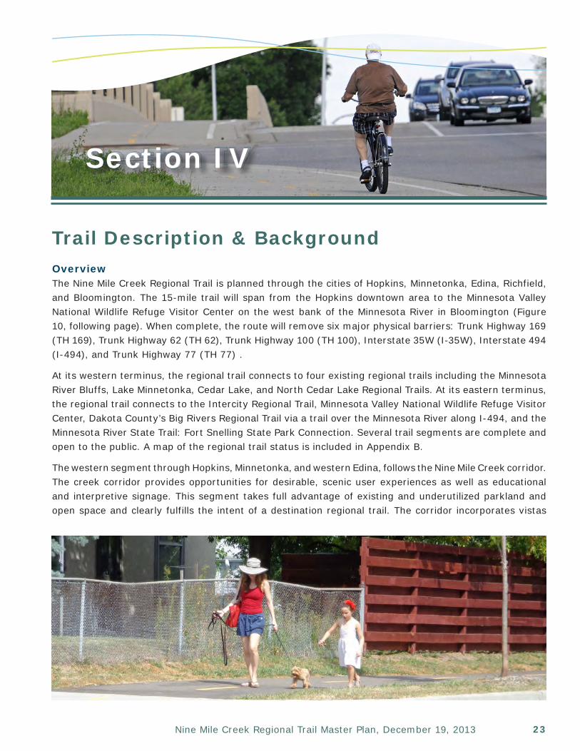
Section IV
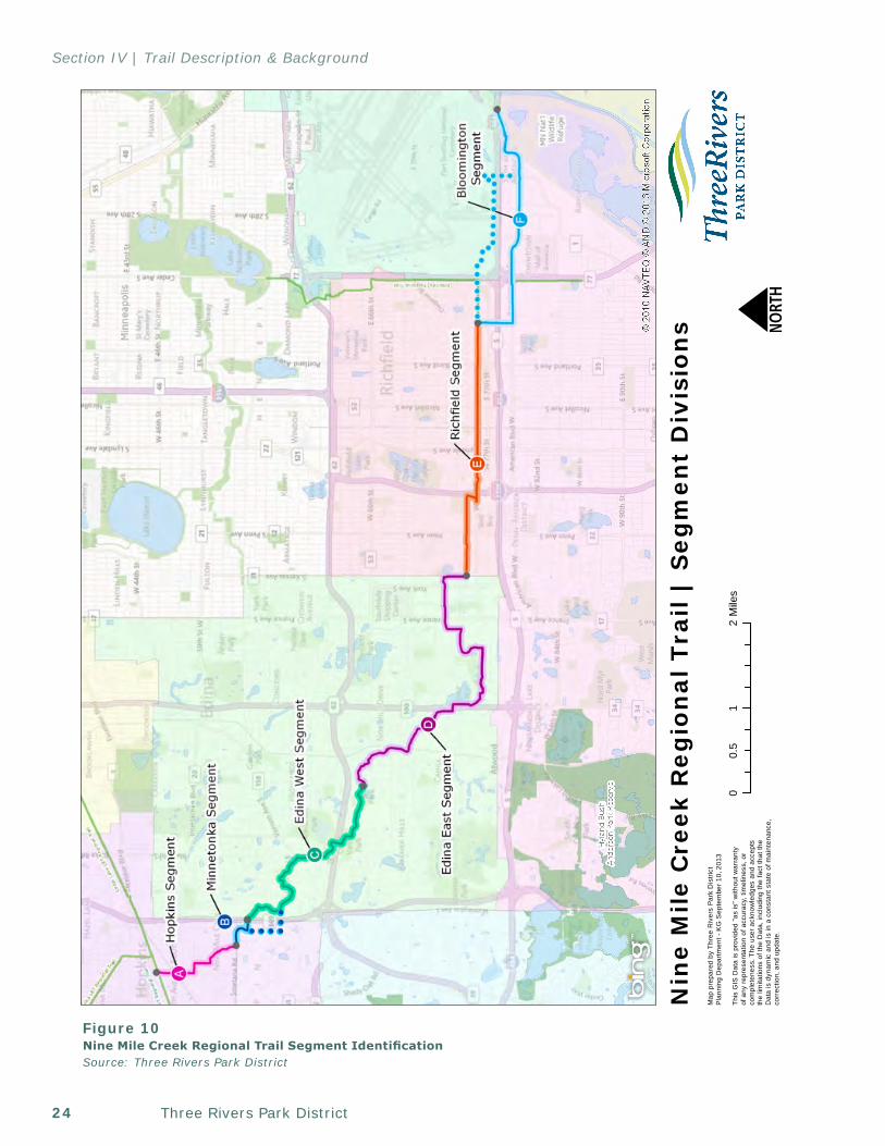
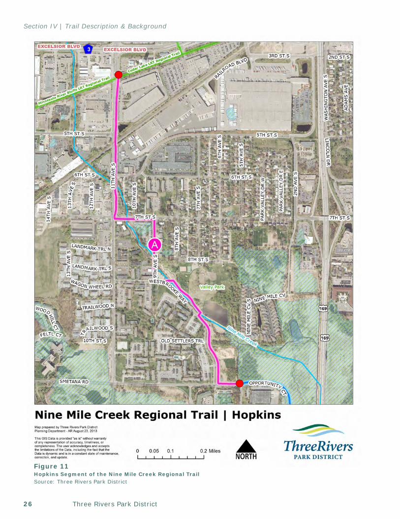
Trail Description & BackgroundOverviewThe Nine Mile Creek Regional Trail is planned through the cities of Hopkins, Minnetonka, Edina, Richfield, and Bloomington. The 15-mile trail will span from the Hopkins downtown area to the Minnesota Valley National Wildlife Refuge Visitor Center on the west bank of the Minnesota River in Bloomington (Figure 10, following page). When complete, the route will remove six major physical barriers: Trunk Highway 169 (TH 169), Trunk Highway 62 (TH 62), Trunk Highway 100 (TH 100), Interstate 35W (I-35W), Interstate 494 (I-494), and Trunk Highway 77 (TH 77) .
At its western terminus, the regional trail connects to four existing regional trails including the Minnesota River Bluffs, Lake Minnetonka, Cedar Lake, and North Cedar Lake Regional Trails. At its eastern terminus, the regional trail connects to the Intercity Regional Trail, Minnesota Valley National Wildlife Refuge Visitor Center, Dakota County’s Big Rivers Regional Trail via a trail over the Minnesota River along I-494, and the Minnesota River State Trail: Fort Snelling State Park Connection. Several trail segments are complete and open to the public. A map of the regional trail status is included in Appendix B.
The western segment through Hopkins, Minnetonka, and western Edina, follows the Nine Mile Creek corridor. The creek corridor provides opportunities for desirable, scenic user experiences as well as educational and interpretive signage. This segment takes full advantage of existing and underutilized parkland and open space and clearly fulfills the intent of a destination regional trail. The corridor incorporates vistas
Three Rivers Park District24
Section IV | Trail Description & Background
01
20.
5M
iles
Nin
e M
ile C
reek
Reg
ion
al T
rail
| S
egm
ent
Div
isio
ns N
Map
pre
pare
d by
Thr
ee R
iver
s P
ark
Dis
tric
tP
lann
ing
Dep
artm
ent -
KG
Sep
tem
ber
10, 2
013
This
GIS
Dat
a is
pro
vide
d "a
s is
" w
ithou
t war
rant
y of
any
repr
esen
tatio
n of
acc
urac
y, ti
mel
ines
s, o
r co
mpl
eten
ess.
The
use
r ack
now
ledg
es a
nd a
ccep
tsth
e lim
itatio
ns o
f the
Dat
a, in
clud
ing
the
fact
that
the
Dat
a is
dyn
amic
and
is in
a c
onst
ant s
tate
of m
a int
enan
ce,
corr
ectio
n, a
nd u
pdat
e.! ! ! !
!!
! ! ! !
!!
!!!!!!!!!!
!!!!!!!!
!!!!!
!!
!!
!!
!!
!
!
!!
!!
!!
!!
!! ! ! !
Figure 10Nine Mile Creek Regional Trail Segment IdentificationSource: Three Rivers Park District
25Nine Mile Creek Regional Trail Master Plan, December 19, 2013
Section IV | Trail Description & Background
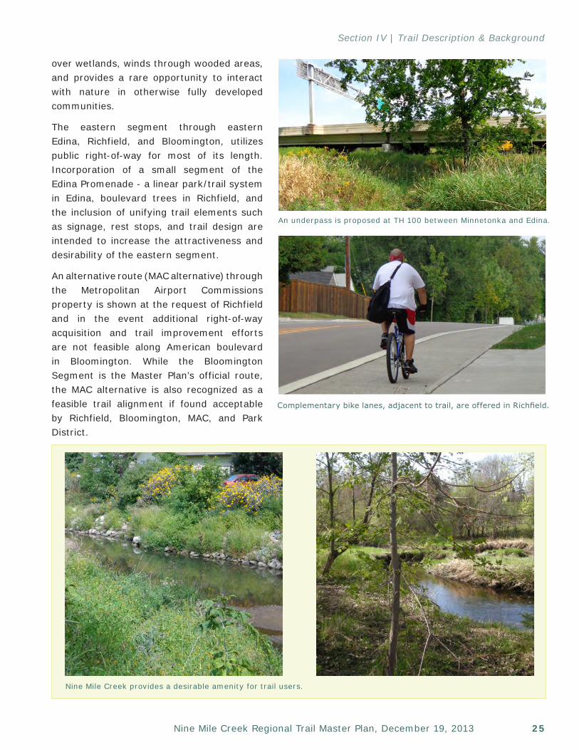
over wetlands, winds through wooded areas, and provides a rare opportunity to interact with nature in otherwise fully developed communities.
The eastern segment through eastern Edina, Richfield, and Bloomington, utilizes public right-of-way for most of its length. Incorporation of a small segment of the Edina Promenade - a linear park/trail system in Edina, boulevard trees in Richfield, and the inclusion of unifying trail elements such as signage, rest stops, and trail design are intended to increase the attractiveness and desirability of the eastern segment.
An alternative route (MAC alternative) through the Metropolitan Airport Commissions property is shown at the request of Richfield and in the event additional right-of-way acquisition and trail improvement efforts are not feasible along American boulevard in Bloomington. While the Bloomington Segment is the Master Plan’s official route, the MAC alternative is also recognized as a feasible trail alignment if found acceptable by Richfield, Bloomington, MAC, and Park District.
Nine Mile Creek provides a desirable amenity for trail users.
An underpass is proposed at TH 100 between Minnetonka and Edina.
Complementary bike lanes, adjacent to trail, are offered in Richfield.
Three Rivers Park District26
Section IV | Trail Description & Background
Figure 11Hopkins Segment of the Nine Mile Creek Regional TrailSource: Three Rivers Park District
27Nine Mile Creek Regional Trail Master Plan, December 19, 2013
Section IV | Trail Description & Background
Hopkins SegmentLocation and StatusThe 1.15-mile regional trail segment (Figure 11) originates at the Minnesota River Bluffs LRT Regional Trail and extends south along the east side of 11th Avenue to 7th Street. This segment is complete, but will require improvements to meet typical regional trail standards. Improvements are proposed to occur at a later date and preferably in association with future road improvements.
At 7th Street, the trail continues east along the southern right-of-way for two blocks to 9th Avenue. At 9th Avenue, the trail extends south and follows the western right-of-way south to Westbrooke Way. The segments along 7th Street and 9th Avenue are proposed for construction in 2016 as part of a Hopkins street reconstruction initiative.
At Westbrooke Way, the trail is located along of the western border of Valley Park and parallels Nine Mile Creek to Smetana Road. This trail segment was completed in 2012 through a collaborative project with Nine Mile Creek Watershed District and Hopkins to restore Nine Mile Creek and build the regional trail segment.
efforts included shoreline stabilization, addition of native vegetation, and reintroduction of meanders to the creek channel. To protect the quality and integrity of the natural resources, the trail is routed in a manner to avoid significant natural resources and minimize potentially negative impacts such as stormwater runoff. No rare, threatened, or species of special concern are located within one mile of the Hopkins trail segment.
Natural areas as classified by the Minnesota Land Cover Classification System associated with this segment include wetland and herbaceous land covers (Appendix C). The greater area is predominantly artificial surfaces (pavement, buildings, etc.) and cultural vegetation (mowed lawns, agriculture, etc.).
Acquisition NeedsAn easement along 11th Avenue is required to meet regional trail standards.
Portions of the Nine Mile Creek Regional Trail through Hopkins exist, such as this trail crossing of the creek.
Context and DestinationsThe Hopkins trail segment is primarily located adjacent to open space, industrial, and medium density residential land uses. Areas of interest include downtown Hopkins, future Southwest Light Rail Transit, the Minnesota River Bluffs, Lake Minnetonka, Cedar Lake, and North Cedar Lake Regional Trails, and Valley Park. Valley Park is one of Hopkins largest parks and includes a playground, basketball court, softball field, tennis courts, sand volleyball court, archery range, nature trails, ice skating rink, outdoor hockey rink, sledding hill, and picnic amenities. Bathrooms, water, and parking are located within the park and by the nature of their location, support the regional trail.
The Nine Mile Creek Regional Trail also connects to Metro Transit bus routes 12 and 568 in Hopkins.
Natural ResourcesVegetation within the 16-20’-wide regional trail corridor will generally be limited to a 3-5’ mowed turf strip on each side of the trail. The natural resource value of the corridor stems not from the corridor itself but from the adjacent landscape.
Nine Mile Creek and its associated floodplains, wetlands, and dedicated open space are the predominant natural resources associated with Nine Mile Creek Regional Trail in Hopkins. The Nine Mile Creek corridor was restored in 2012. Restoration
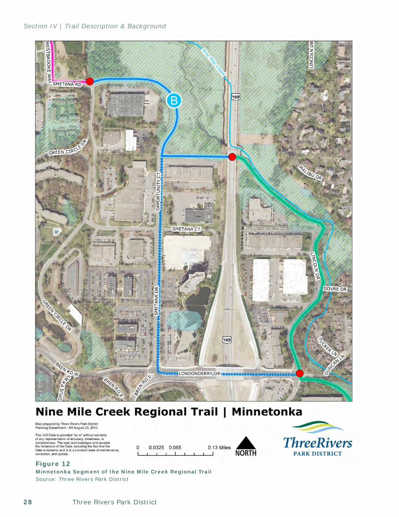
Three Rivers Park District28
Section IV | Trail Description & Background
Figure 12Minnetonka Segment of the Nine Mile Creek Regional TrailSource: Three Rivers Park District
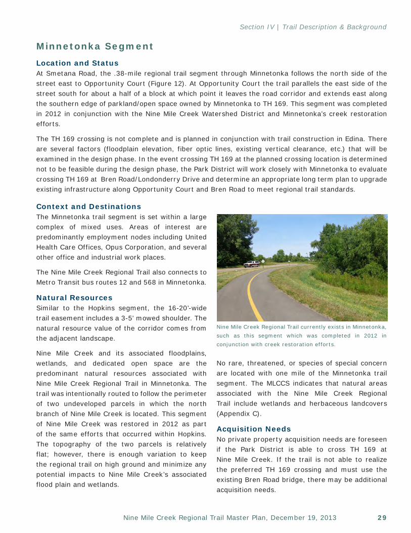
29Nine Mile Creek Regional Trail Master Plan, December 19, 2013
Section IV | Trail Description & Background
Minnetonka SegmentLocation and StatusAt Smetana Road, the .38-mile regional trail segment through Minnetonka follows the north side of the street east to Opportunity Court (Figure 12). At Opportunity Court the trail parallels the east side of the street south for about a half of a block at which point it leaves the road corridor and extends east along the southern edge of parkland/open space owned by Minnetonka to TH 169. This segment was completed in 2012 in conjunction with the Nine Mile Creek Watershed District and Minnetonka’s creek restoration efforts.
The TH 169 crossing is not complete and is planned in conjunction with trail construction in Edina. There are several factors (floodplain elevation, fiber optic lines, existing vertical clearance, etc.) that will be examined in the design phase. In the event crossing TH 169 at the planned crossing location is determined not to be feasible during the design phase, the Park District will work closely with Minnetonka to evaluate crossing TH 169 at Bren Road/Londonderry Drive and determine an appropriate long term plan to upgrade existing infrastructure along Opportunity Court and Bren Road to meet regional trail standards.
No rare, threatened, or species of special concern are located with one mile of the Minnetonka trail segment. The MLCCS indicates that natural areas associated with the Nine Mile Creek Regional Trail include wetlands and herbaceous landcovers (Appendix C).
Acquisition NeedsNo private property acquisition needs are foreseen if the Park District is able to cross TH 169 at Nine Mile Creek. If the trail is not able to realize the preferred TH 169 crossing and must use the existing Bren Road bridge, there may be additional acquisition needs.
Nine Mile Creek Regional Trail currently exists in Minnetonka, such as this segment which was completed in 2012 in conjunction with creek restoration efforts.
Context and DestinationsThe Minnetonka trail segment is set within a large complex of mixed uses. Areas of interest are predominantly employment nodes including United Health Care Offices, Opus Corporation, and several other office and industrial work places.
The Nine Mile Creek Regional Trail also connects to Metro Transit bus routes 12 and 568 in Minnetonka.
Natural ResourcesSimilar to the Hopkins segment, the 16-20’-wide trail easement includes a 3-5’ mowed shoulder. The natural resource value of the corridor comes from the adjacent landscape.
Nine Mile Creek and its associated floodplains, wetlands, and dedicated open space are the predominant natural resources associated with Nine Mile Creek Regional Trail in Minnetonka. The trail was intentionally routed to follow the perimeter of two undeveloped parcels in which the north branch of Nine Mile Creek is located. This segment of Nine Mile Creek was restored in 2012 as part of the same efforts that occurred within Hopkins. The topography of the two parcels is relatively flat; however, there is enough variation to keep the regional trail on high ground and minimize any potential impacts to Nine Mile Creek’s associated flood plain and wetlands.
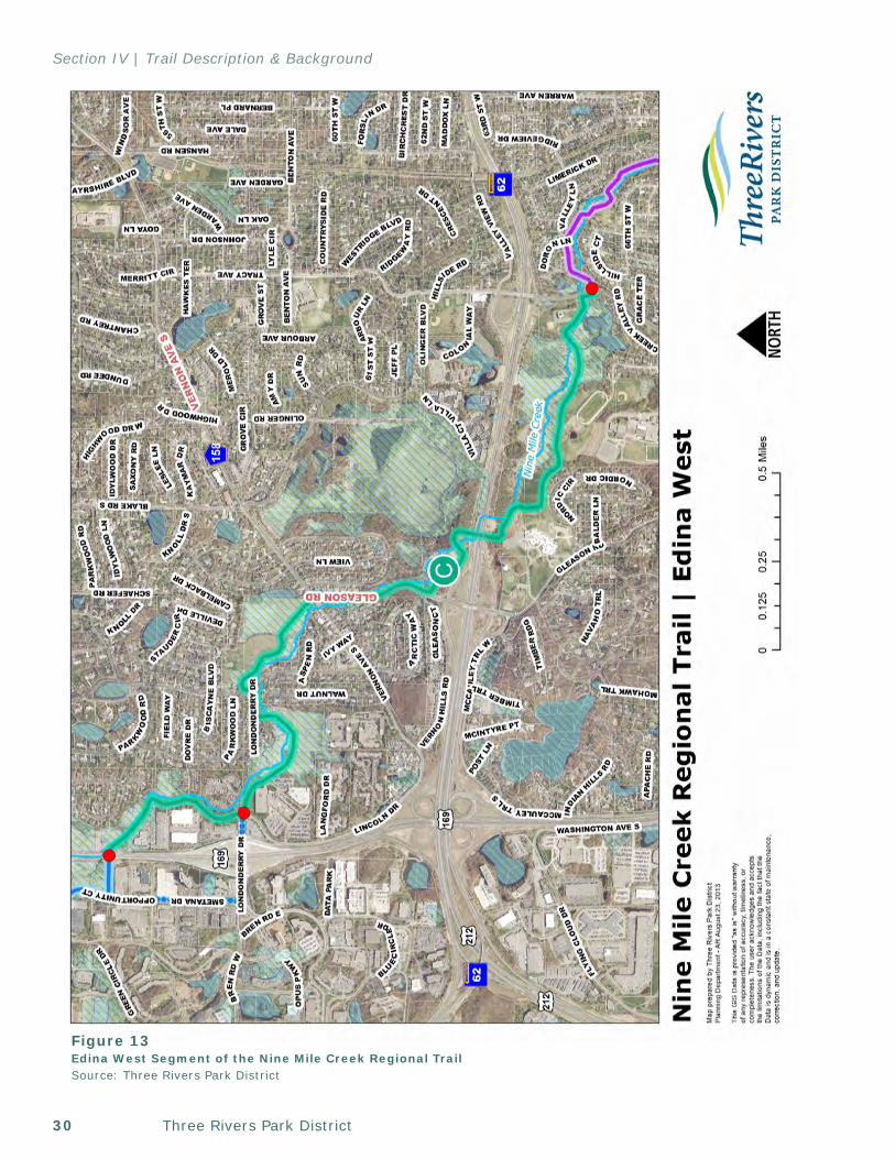
Three Rivers Park District30
Section IV | Trail Description & Background
Figure 13Edina West Segment of the Nine Mile Creek Regional TrailSource: Three Rivers Park District
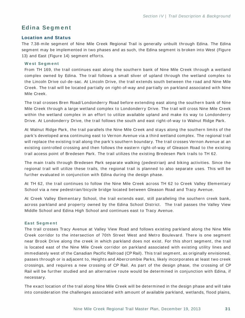
31Nine Mile Creek Regional Trail Master Plan, December 19, 2013
Section IV | Trail Description & Background
Edina SegmentLocation and StatusThe 7.38-mile segment of Nine Mile Creek Regional Trail is generally unbuilt through Edina. The Edina segment may be implemented in two phases and as such, the Edina segment is broken into West (Figure 13) and East (Figure 14) segment efforts.
West SegmentFrom TH 169, the trail continues east along the southern bank of Nine Mile Creek through a wetland complex owned by Edina. The trail follows a small sliver of upland through the wetland complex to the Lincoln Drive cul-de-sac. At Lincoln Drive, the trail extends south between the road and Nine Mile Creek. The trail will be located partially on right-of-way and partially on parkland associated with Nine Mile Creek.
The trail crosses Bren Road/Londonderry Road before extending east along the southern bank of Nine Mile Creek through a large wetland complex to Londonderry Drive. The trail will cross Nine Mile Creek within the wetland complex in an effort to utilize available upland and make its way to Londonderry Drive. At Londonderry Drive, the trail follows the south and east right-of-way to Walnut Ridge Park.
At Walnut Ridge Park, the trail parallels the Nine Mile Creek and stays along the southern limits of the park’s developed area continuing east to Vernon Avenue via a third wetland complex. The regional trail will replace the existing trail along the park’s southern boundary. The trail crosses Vernon Avenue at an existing controlled crossing and then follows the eastern right-of-way of Gleason Road to the existing trail access point of Bredesen Park. The trail utilizes the existing Bredesen Park trails to TH 62.
The main trails through Bredesen Park separate walking (pedestrian) and biking activities. Since the regional trail will utilize these trails, the regional trail is planned to also separate uses. This will be further evaluated in conjunction with Edina during the design phase.
At TH 62, the trail continues to follow the Nine Mile Creek across TH 62 to Creek Valley Elementary School via a new pedestrian/bicycle bridge located between Gleason Road and Tracy Avenue.
At Creek Valley Elementary School, the trail extends east, still paralleling the southern creek bank, across parkland and property owned by the Edina School District. The trail passes the Valley View Middle School and Edina High School and continues east to Tracy Avenue.
East SegmentThe trail crosses Tracy Avenue at Valley View Road and follows existing parkland along the Nine Mile Creek corridor to the intersection of 70th Street West and Metro Boulevard. There is one segment near Brook Drive along the creek in which parkland does not exist. For this short segment, the trail is located east of the Nine Mile Creek corridor on parkland associated with existing utility lines and immediately west of the Canadian Pacific Railroad (CP Rail). This trail segment, as originally envisioned, passes through or is adjacent to, Heights and Abercrombie Parks, likely incorporates at least two creek crossings, and requires a new crossing of CP Rail. As part of the design phase, the crossing of CP Rail will be further studied and an alternative route would be determined in conjunction with Edina, if necessary.
The exact location of the trail along Nine Mile Creek will be determined in the design phase and will take into consideration the challenges associated with amount of available parkland, wetlands, flood plains,
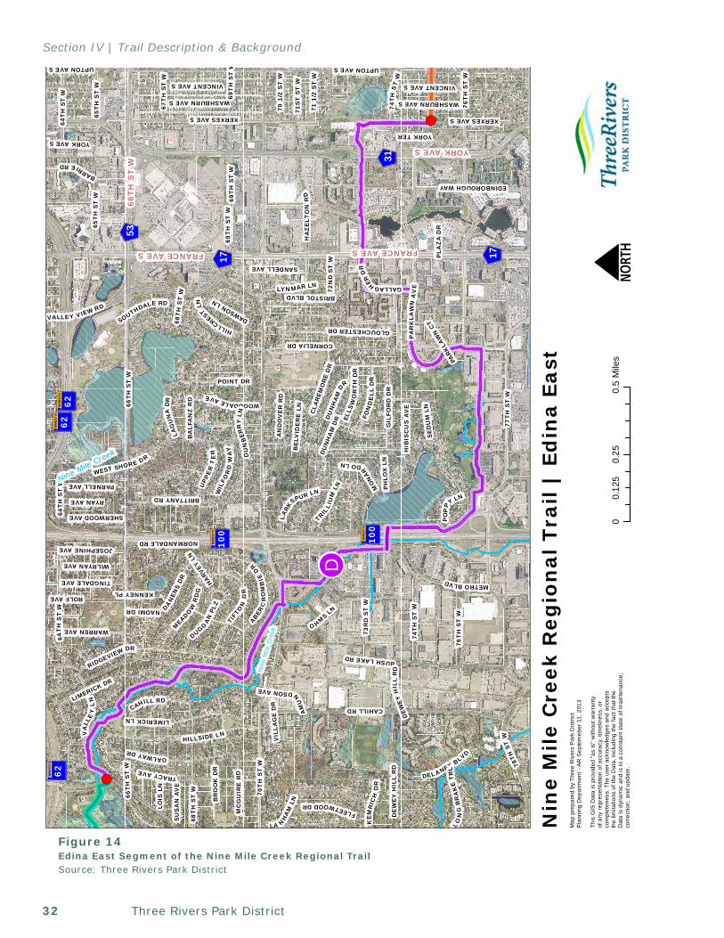
Three Rivers Park District32
Section IV | Trail Description & Background
!!D
! (
! (
Nin
eM
ileC
reek
?A@100
?A@62?A@62
?A@62
?A@100
GWX31
GWX17
GWX53
GWX17
66T
H S
T W
UPTON AVE S
CAHILL RD
77T
H S
T W
70T
H S
T W
WEST SHORE DR
64T
H S
T W
CORNELIA DR
METROBLVD
69T
H S
T W
78TH
STW
WOODDALEAVE
BR
OO
K D
R
65T
H S
T W
RIDGEVIEW DR
DU
NB
ERR
YLN
BUSHLAKERD
O HMSLN
68T
H S
T W
VALLEY VIEW RD
DAN
ENS
DR
XERXES AVE S
HIB
ISC
US
AV
E
LA NH
AM
LN
LIMERICKLN
HILLSIDE LN
HA
ZE
LTO
NR
D
VINCENT AVE S
VA
LLE
YL
N
74T
H S
T W
PA
RK
LAW
NA
VE
LIMERICK DR
BARRIERD
TIFT
ON
DR
SOUTHDALE RD
DELANEY BLVD
WARREN AVE
DE
WE
Y H
ILL
RD
76T
H S
T W
BRITTANY RD
GIL
FOR
D D
R
MEADO
WR
DG
GALWAYDR
POINT DR
NORMANDALE RD
RYAN AVE
EDINBOROUGH WAY
LYNMAR LN
WILRYAN AVE
ABERC
RO
MB
IED
R
UPP
ER
TE
R
MC
GU
IRE
RD
67T
H S
T W
FON
DE
LLD
R
TINGDALE AVE
TRACYAVE
PARNELL AVE
FLEETWOODDR
70 1
/2 S
T W
71 1
/2 S
T W
TRIL
LIU
MLN
JOSEPHINE AVE
71S
T S
T W
LARK
SPUR LN
DUGGA
NPL
ZW
ILFO
RD
WA
Y
LOIS
LN
AN
DO
VE
R R
D
SHERWOOD AVE
GALLAGHERDR
WASHBURN AVE S
ROLF AVE
SE
DU
M L
N
SU
SA
N A
VE
KE
MR
ICH
DR
ELLS
WO
RT
HD
R
YORK AVE S
DU
NH
AM
DR
HILLCRESTLN
NAOMI DR
DAWSON LN
LON
GB
RA
KE
TR
L
LAG
UN
AD
R
YORK TER
73R
D S
T W
CLA
REM
OR
E D
R
GLOUCHESTER DR
PLA
ZA
DR
BA
LFA
NZ
RD
BRISTOL BLVD 72N
D S
T W
BE
LVID
ER
E L
NA
MU
N
DSONAVE
PO
PPY
LN
MON
AR
DOLN
HARV
EY L
N
VIL
LAG
E D
R
SANDELL AVE
KENNEY PL
PH
LOX
LN
PARK
LAW
N C
T
WASHBURN AVE S
XERXES AVE S
DU
NH
AM
DR
66T
H S
T W
UPTON AVE S
69T
H S
T W
76T
H S
T W
69T
H S
T W
DEW
EYH
ILL
RD
64T
H S
T W
VINCENT AVE S
64T
HS
TW
65T
H S
T W
68T
H S
T W
CAHILL RD
74T
HS
TW
FRANCE AVE S
YORK AVE S
66T
H S
T W
FRANCE AVE S
00.
250.
50.
125
Mile
s
Nin
e M
ile C
reek
Reg
ion
al T
rail
| Ed
ina
East
NM
ap p
repa
red
by T
hree
Riv
ers
Par
k D
istr
ict
Pla
nnin
g D
epar
tmen
t - A
R S
epte
meb
er 1
1, 2
013
This
GIS
Dat
a is
pro
vide
d "a
s is
" w
ithou
t war
rant
y of
any
rep
rese
ntat
ion
of a
ccur
acy,
tim
elin
ess,
or
com
plet
enes
s. T
he u
ser a
ckno
wle
dges
and
acc
epts
the
limita
tions
of t
he D
ata,
incl
udin
g th
e fa
ct th
at th
e D
ata
is d
ynam
ic a
nd is
in a
con
stan
t sta
te o
f mai
nten
ance
,co
rrec
tion,
and
upd
ate.
Nine Mile Creek
Figure 14Edina East Segment of the Nine Mile Creek Regional TrailSource: Three Rivers Park District
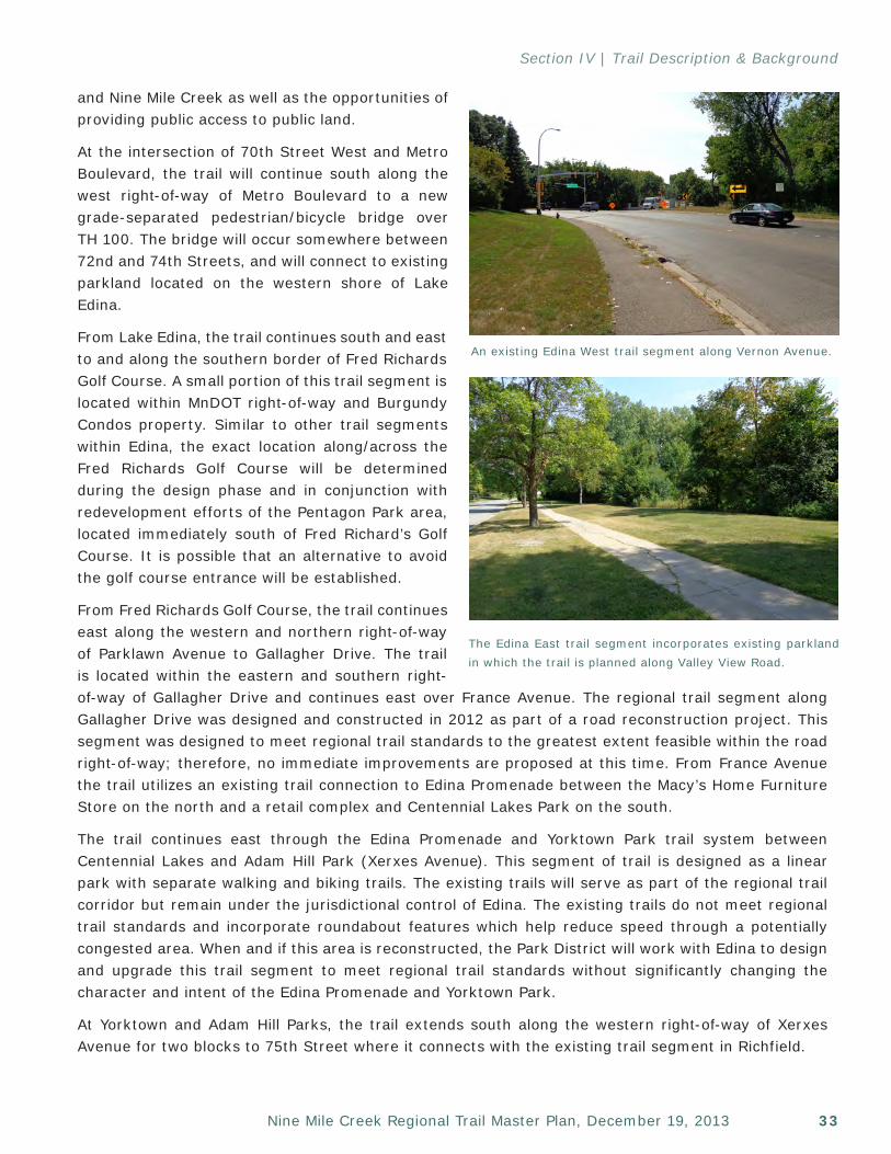
33Nine Mile Creek Regional Trail Master Plan, December 19, 2013
Section IV | Trail Description & Background
and Nine Mile Creek as well as the opportunities of providing public access to public land.
At the intersection of 70th Street West and Metro Boulevard, the trail will continue south along the west right-of-way of Metro Boulevard to a new grade-separated pedestrian/bicycle bridge over TH 100. The bridge will occur somewhere between 72nd and 74th Streets, and will connect to existing parkland located on the western shore of Lake Edina.
From Lake Edina, the trail continues south and east to and along the southern border of Fred Richards Golf Course. A small portion of this trail segment is located within MnDOT right-of-way and Burgundy Condos property. Similar to other trail segments within Edina, the exact location along/across the Fred Richards Golf Course will be determined during the design phase and in conjunction with redevelopment efforts of the Pentagon Park area, located immediately south of Fred Richard’s Golf Course. It is possible that an alternative to avoid the golf course entrance will be established.
From Fred Richards Golf Course, the trail continues east along the western and northern right-of-way of Parklawn Avenue to Gallagher Drive. The trail is located within the eastern and southern right-of-way of Gallagher Drive and continues east over France Avenue. The regional trail segment along Gallagher Drive was designed and constructed in 2012 as part of a road reconstruction project. This segment was designed to meet regional trail standards to the greatest extent feasible within the road right-of-way; therefore, no immediate improvements are proposed at this time. From France Avenue the trail utilizes an existing trail connection to Edina Promenade between the Macy’s Home Furniture Store on the north and a retail complex and Centennial Lakes Park on the south.
The trail continues east through the Edina Promenade and Yorktown Park trail system between Centennial Lakes and Adam Hill Park (Xerxes Avenue). This segment of trail is designed as a linear park with separate walking and biking trails. The existing trails will serve as part of the regional trail corridor but remain under the jurisdictional control of Edina. The existing trails do not meet regional trail standards and incorporate roundabout features which help reduce speed through a potentially congested area. When and if this area is reconstructed, the Park District will work with Edina to design and upgrade this trail segment to meet regional trail standards without significantly changing the character and intent of the Edina Promenade and Yorktown Park.
At Yorktown and Adam Hill Parks, the trail extends south along the western right-of-way of Xerxes Avenue for two blocks to 75th Street where it connects with the existing trail segment in Richfield.
An existing Edina West trail segment along Vernon Avenue.
The Edina East trail segment incorporates existing parkland in which the trail is planned along Valley View Road.
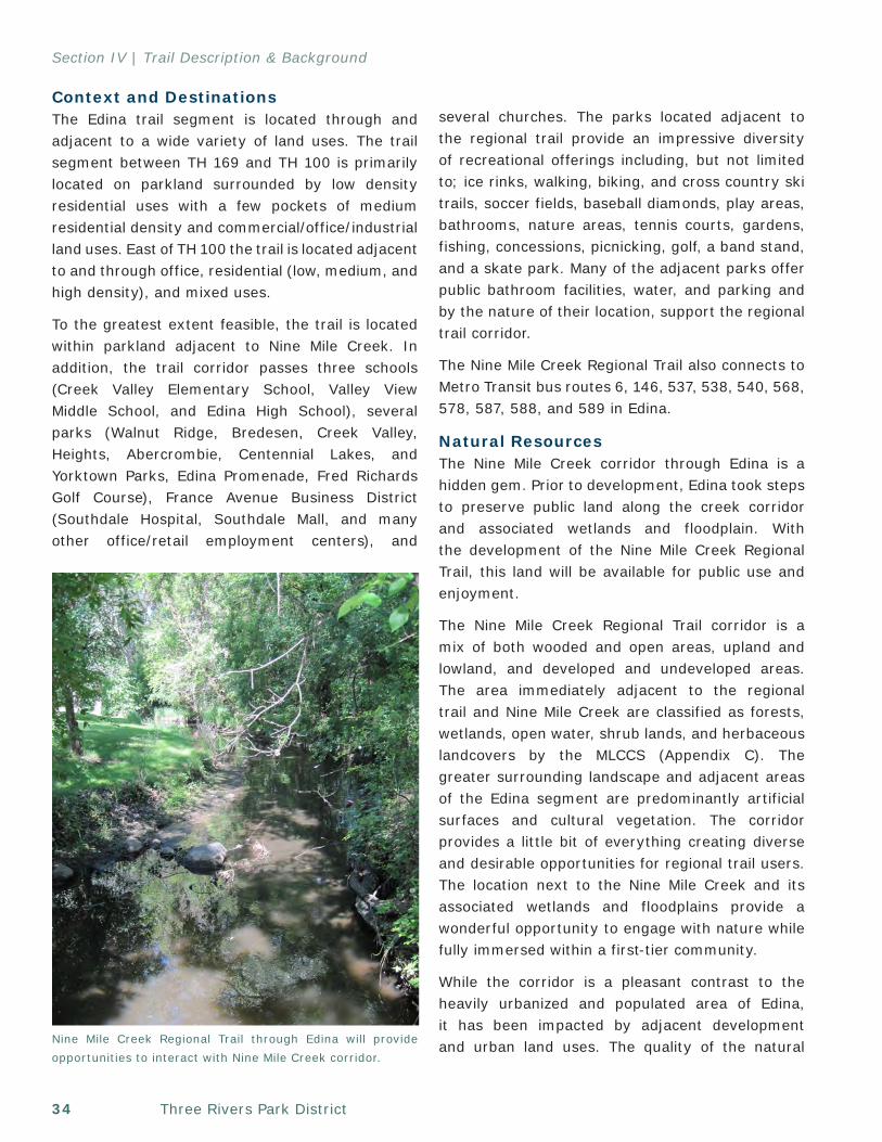
Three Rivers Park District34
Section IV | Trail Description & Background
Context and DestinationsThe Edina trail segment is located through and adjacent to a wide variety of land uses. The trail segment between TH 169 and TH 100 is primarily located on parkland surrounded by low density residential uses with a few pockets of medium residential density and commercial/office/industrial land uses. East of TH 100 the trail is located adjacent to and through office, residential (low, medium, and high density), and mixed uses.
To the greatest extent feasible, the trail is located within parkland adjacent to Nine Mile Creek. In addition, the trail corridor passes three schools (Creek Valley Elementary School, Valley View Middle School, and Edina High School), several parks (Walnut Ridge, Bredesen, Creek Valley, Heights, Abercrombie, Centennial Lakes, and Yorktown Parks, Edina Promenade, Fred Richards Golf Course), France Avenue Business District (Southdale Hospital, Southdale Mall, and many other office/retail employment centers), and
several churches. The parks located adjacent to the regional trail provide an impressive diversity of recreational offerings including, but not limited to; ice rinks, walking, biking, and cross country ski trails, soccer fields, baseball diamonds, play areas, bathrooms, nature areas, tennis courts, gardens, fishing, concessions, picnicking, golf, a band stand, and a skate park. Many of the adjacent parks offer public bathroom facilities, water, and parking and by the nature of their location, support the regional trail corridor.
The Nine Mile Creek Regional Trail also connects to Metro Transit bus routes 6, 146, 537, 538, 540, 568, 578, 587, 588, and 589 in Edina.
Natural ResourcesThe Nine Mile Creek corridor through Edina is a hidden gem. Prior to development, Edina took steps to preserve public land along the creek corridor and associated wetlands and floodplain. With the development of the Nine Mile Creek Regional Trail, this land will be available for public use and enjoyment.
The Nine Mile Creek Regional Trail corridor is a mix of both wooded and open areas, upland and lowland, and developed and undeveloped areas. The area immediately adjacent to the regional trail and Nine Mile Creek are classified as forests, wetlands, open water, shrub lands, and herbaceous landcovers by the MLCCS (Appendix C). The greater surrounding landscape and adjacent areas of the Edina segment are predominantly artificial surfaces and cultural vegetation. The corridor provides a little bit of everything creating diverse and desirable opportunities for regional trail users. The location next to the Nine Mile Creek and its associated wetlands and floodplains provide a wonderful opportunity to engage with nature while fully immersed within a first-tier community.
While the corridor is a pleasant contrast to the heavily urbanized and populated area of Edina, it has been impacted by adjacent development and urban land uses. The quality of the natural Nine Mile Creek Regional Trail through Edina will provide
opportunities to interact with Nine Mile Creek corridor.
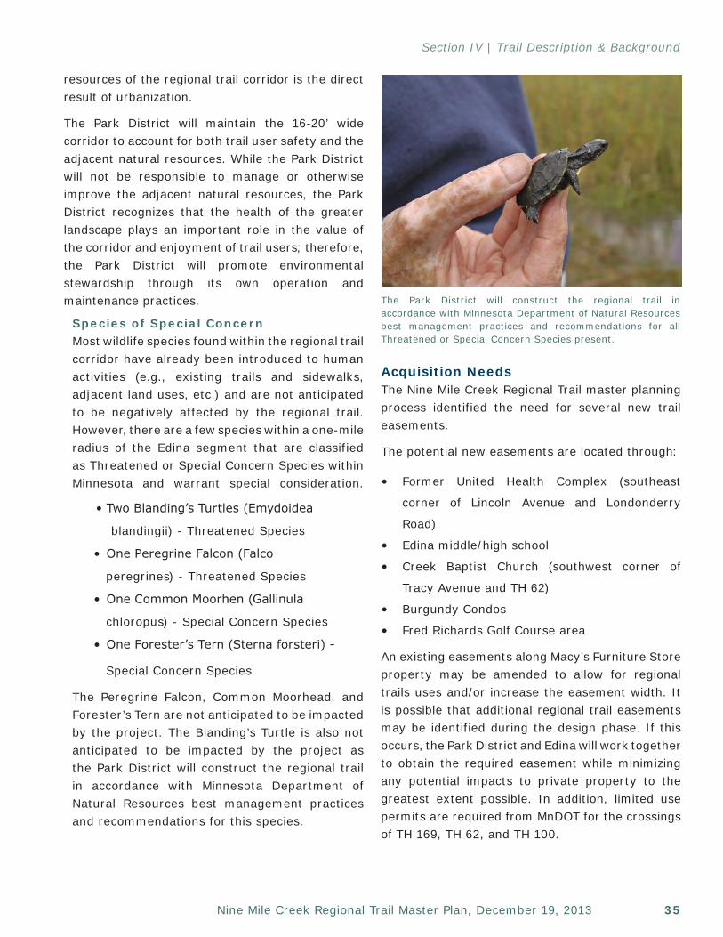
35Nine Mile Creek Regional Trail Master Plan, December 19, 2013
Section IV | Trail Description & Background
resources of the regional trail corridor is the direct result of urbanization.
The Park District will maintain the 16-20’ wide corridor to account for both trail user safety and the adjacent natural resources. While the Park District will not be responsible to manage or otherwise improve the adjacent natural resources, the Park District recognizes that the health of the greater landscape plays an important role in the value of the corridor and enjoyment of trail users; therefore, the Park District will promote environmental stewardship through its own operation and maintenance practices.
Species of Special ConcernMost wildlife species found within the regional trail corridor have already been introduced to human activities (e.g., existing trails and sidewalks, adjacent land uses, etc.) and are not anticipated to be negatively affected by the regional trail. However, there are a few species within a one-mile radius of the Edina segment that are classified as Threatened or Special Concern Species within Minnesota and warrant special consideration.
• Two Blanding’s Turtles (Emydoidea
blandingii) - Threatened Species
• One Peregrine Falcon (Falco
peregrines) - Threatened Species
• One Common Moorhen (Gallinula
chloropus) - Special Concern Species
• One Forester’s Tern (Sterna forsteri) -
Special Concern Species
The Peregrine Falcon, Common Moorhead, and Forester’s Tern are not anticipated to be impacted by the project. The Blanding’s Turtle is also not anticipated to be impacted by the project as the Park District will construct the regional trail in accordance with Minnesota Department of Natural Resources best management practices and recommendations for this species.
Acquisition NeedsThe Nine Mile Creek Regional Trail master planning process identified the need for several new trail easements.
The potential new easements are located through:
• Former United Health Complex (southeast
corner of Lincoln Avenue and Londonderry
Road)
• Edina middle/high school
• Creek Baptist Church (southwest corner of
Tracy Avenue and TH 62)
• Burgundy Condos
• Fred Richards Golf Course area
An existing easements along Macy’s Furniture Store property may be amended to allow for regional trails uses and/or increase the easement width. It is possible that additional regional trail easements may be identified during the design phase. If this occurs, the Park District and Edina will work together to obtain the required easement while minimizing any potential impacts to private property to the greatest extent possible. In addition, limited use permits are required from MnDOT for the crossings of TH 169, TH 62, and TH 100.
The Park District will construct the regional trail in accordance with Minnesota Department of Natural Resources best management practices and recommendations for all Threatened or Special Concern Species present.
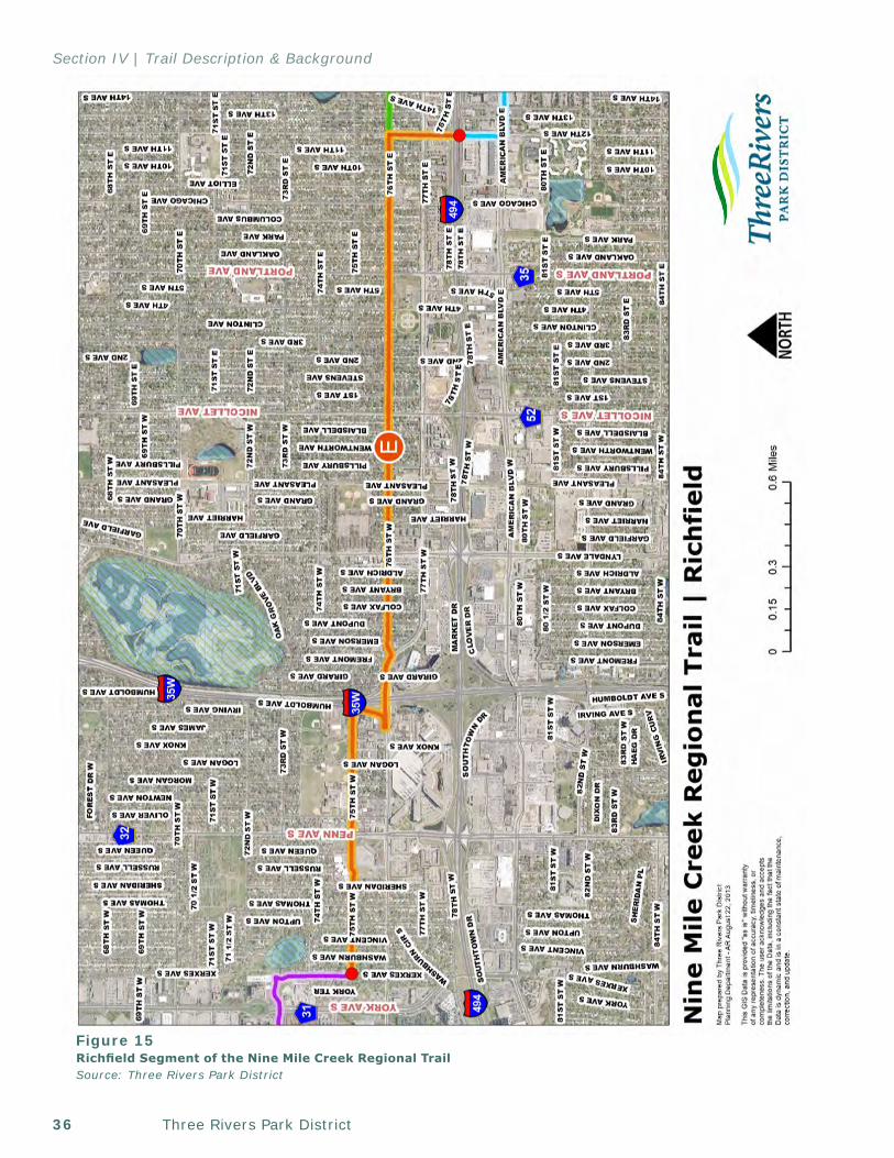
Three Rivers Park District36
Section IV | Trail Description & Background
Figure 15Richfield Segment of the Nine Mile Creek Regional TrailSource: Three Rivers Park District
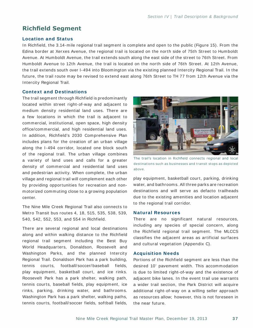
37Nine Mile Creek Regional Trail Master Plan, December 19, 2013
Section IV | Trail Description & Background
Richfield SegmentLocation and StatusIn Richfield, the 3.14-mile regional trail segment is complete and open to the public (Figure 15). From the Edina border at Xerxes Avenue, the regional trail is located on the north side of 75th Street to Humboldt Avenue. At Humboldt Avenue, the trail extends south along the east side of the street to 76th Street. From Humboldt Avenue to 12th Avenue, the trail is located on the north side of 76th Street. At 12th Avenue, the trail extends south over I-494 into Bloomington via the existing planned Intercity Regional Trail. In the future, the trail route may be revised to extend east along 76th Street to TH 77 from 12th Avenue via the Intercity Regional Trail.
Context and DestinationsThe trail segment through Richfield is predominantly located within street right-of-way and adjacent to medium density residential land uses. There are a few locations in which the trail is adjacent to commercial, institutional, open space, high density office/commercial, and high residential land uses. In addition, Richfield’s 2030 Comprehensive Plan includes plans for the creation of an urban village along the I-494 corridor, located one block south of the regional trail. The urban village combines a variety of land uses and calls for a greater density of commercial and residential land uses and pedestrian activity. When complete, the urban village and regional trail will complement each other by providing opportunities for recreation and non-motorized commuting close to a growing population center.
The Nine Mile Creek Regional Trail also connects to Metro Transit bus routes 4, 18, 515, 535, 538, 539, 540, 542, 552, 553, and 554 in Richfield.
There are several regional and local destinations along and within walking distance to the Richfield regional trail segment including the Best Buy World Headquarters, Donaldson, Roosevelt and Washington Parks, and the planned Intercity Regional Trail. Donaldson Park has a park building, tennis courts, football/soccer/baseball fields, play equipment, basketball court, and ice rinks. Roosevelt Park has a park shelter, walking path, tennis courts, baseball fields, play equipment, ice rinks, parking, drinking water, and bathrooms. Washington Park has a park shelter, walking paths, tennis courts, football/soccer fields, softball fields,
play equipment, basketball court, parking, drinking water, and bathrooms. All three parks are recreation destinations and will serve as defacto trailheads due to the existing amenities and location adjacent to the regional trail corridor.
Natural ResourcesThere are no significant natural resources, including any species of special concern, along the Richfield regional trail segment. The MLCCS classifies the adjacent areas as artificial surfaces and cultural vegetation (Appendix C).
Acquisition NeedsPortions of the Richfield segment are less than the desired 10’ pavement width. This accommodation is due to limited right-of-way and the existence of adjacent bike lanes. In the event trail use warrants a wider trail section, the Park District will acquire additional right-of-way on a willing seller approach as resources allow; however, this is not foreseen in the near future.
The trail’s location in Richfield connects regional and local destinations such as businesses and transit stops as depicted above.
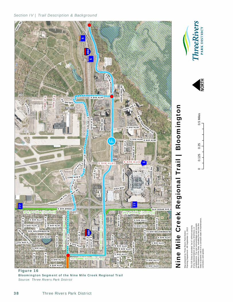
Three Rivers Park District38
Section IV | Trail Description & Background
MN
Nat
'l W
ildlif
eRe
fuge
[Intercity]RegionalTrail
!!F
[Intercity]RegionalTrail
Nin
e M
ile/[
Inte
rcity]
Reg
iona
l Tra
il
Nin
e M
ile/[
Inte
rcity]
Reg
iona
l Tra
il
Nine Mile/[Intercity] Regional Trail
! (
! (
! (
§̈ ¦494
§̈ ¦494
?A@5
?A@77
?A@5
?A@77
GWX1
12TH AVE S
AM
ER
ICA
NBL
VDE
34TH AVE S
13TH AVE S
75T
H S
T E
76T
H S
T E
84T
H S
T E
CEDAR AVE S
AIR
LIN
ELN
17TH AVE S
28TH AVE S
16TH AVE S
OLD CEDAR AVE S
11TH AVE S
10TH AVE S
LONGFELLOWAVE
BLOOMINGTON AVE
83R
D S
T E
30TH AVE S
OLDSHAKOPEE
RD
E
LIN
DA
U L
N
82N
D S
T E
80T
H S
T E
AIR
PO
RT
LN
78T
HS
TE
73R
D S
T E
74T
H S
T E
BLOOMINGTON AVE S
DIAGONALBLV
D
KIL
LEB
RE
WD
R
24TH
AVE S
22ND AVE S
72N
DS
TE
14TH AVE S
POST
RD
77T
HS
TE
81S
T S
T E
ME
TR
O D
R
15TH AVE S
33RD AVE S
AIRLINEDR
IKEA WAY
AP
PLE
TR
EE
SQ
MTC RD
15TH AVE S
78T
HS
TE
17TH AVE S
14TH AVE S
28TH AVE S
11TH AVE S
10TH AVE S
13TH AVE S
77T
H S
T E
80T
H S
T E
80T
H S
T E
78T
HS
TE
78T
HS
TE
75TH
ST
E
14TH AVE S
82N
D S
T E
16TH AVE S
74T
H S
T E
72N
D S
T E
16THAVES
14THAVES
73R
D S
T E
74TH
ST
E
24TH AVE S24TH AVE S
00.
250.
50.
125
Mile
sN
Map
pre
pare
d by
Thr
ee R
iver
s P
ark
Dis
tric
tP
lann
ing
Dep
artm
ent -
AR
Sep
tem
ber 1
1, 2
013
This
GIS
Dat
a is
pro
vide
d "a
s is
" w
ithou
t war
rant
y of
any
repr
esen
tatio
n of
acc
urac
y, ti
mel
ines
s, o
r co
mpl
eten
ess.
The
use
r ack
now
ledg
es a
nd a
ccep
tsth
e lim
itatio
ns o
f the
Dat
a, in
clud
ing
the
fact
that
the
Dat
a is
dyn
amic
and
is in
a c
onst
ant s
tate
of m
aint
enan
ce,
corr
ectio
n, a
nd u
pdat
e.
Nin
e M
ile C
reek
Reg
ion
al T
rail
| B
loo
min
gto
n
Figure 16Bloomington Segment of the Nine Mile Creek Regional TrailSource: Three Rivers Park District
39Nine Mile Creek Regional Trail Master Plan, December 19, 2013
Section IV | Trail Description & Background
Bloomington SegmentLocation and StatusThe Bloomington segment of the regional trail is 3.25 miles long and connects to Minnesota Valley National Wildlife Refuge Visitor Center (Figure 16). This segment utilizes existing sidewalk and trail facilities for much of its length.
The Bloomington segment of the regional trail is planned to utilize the Intercity Regional Trail from 76th Street south along 12th Avenue over I-494 via a new pedestrian/bicycle bridge to American Boulevard and then east to Old Cedar Avenue. At Old Cedar Avenue, the Intercity Regional Trail Corridor extends south to the 86th Street Bikeway and Nine Mile Creek Regional Trail continues east under TH 77 along American Boulevard to the existing trail crossing of the Minnesota River at I-494 adjacent to the Minnesota Valley National Wildlife Refuge Visitor Center. The American Boulevard segment of trail is designated as an enhanced pedestrian way by the Bloomington ATP. As an enhanced pedestrian way, Bloomington envisions this trail segment design to focus on enhancing pedestrian movement in a comfortable streestscape setting while accommodating bicyclists.
Full realization of the Bloomington segment is contingent on the ability to secure additional right-of-way, improve the TH 77 underpass crossing to better accommodate the trail, and improve the existing sidewalk/trail for almost the entire length of the segment.
Given the complexities of these factors, and Richfield’s support for an alternative route through the MAC property, an alternative route is also identified as part of this Master Plan.
MAC Alternative OptionThe MAC alternative option utilizes the existing segment of the Intercity Regional Trail segment along 76th Street from 12th Avenue to Cedar Avenue in Richfield. From Cedar Avenue, the alternative route crosses TH 77 by way of a future TH 77 underpass at 77th Street. This underpass will serve as a reliever to the I-494 corridor and is a high priority for Richfield. From the TH 77 underpass, the trail is located on the north side of 77th Street and extends east to 24th Avenue.
At 24th Avenue, the trail continues south and east along Airport Lane to 34th Avenue through right-of-way under jurisdictional control of MAC and MnDOT. Access to the Minneapolis-St. Paul Airport and Hiawatha LRT is feasible at 34th Avenue and access to Fort Snelling State Park is possible via Post Road. At 34th Avenue the trail will extend south under I-494 via a new diverging diamond interchange that is currently under construction to American Boulevard in Bloomington. From the 34th Avenue/American Boulevard intersection, the trail east along American Boulevard to Minnesota Valley National Wildlife Refuge Visitor Center.
This alternative will be further pursued if American Boulevard is determined to not be feasible. Implementation of this segment is also contingent on agreement between Richfield, MAC, Bloomington and the Park District, that the MAC Alternative Option is preferred over the Bloomington segment, and Richfield and MAC securing the necessary funding, approvals, and support to implement the TH 77 underpass, redevelop the immediate area, and extend the regional trail through MAC property.
Three Rivers Park District40
Section IV | Trail Description & Background
Context and DestinationsThe Bloomington segment is located adjacent to a mix of land uses related to the I-494 corridor and airport.
The Bloomington segment is located within the South Loop District. This area’s current land uses are a mix of office, industrial, and hospitality. Bloomington’s South Loop calls for this area to transition to a greater variety of uses, including high density residential at the east end of the segment. The Alternative MAC Option is adjacent to large parking lots, Metro Transit garage, warehouses, runways, and Fort Snelling Cemetery.
Key destinations along or near the corridor include the Minneapolis-St. Paul Airport, Hiawatha LRT (blue line), Mall of America, IKEA, and Minnesota Valley National Wildlife Refuge. The Minnesota Valley National Wildlife Refuge offers opportunities for hiking, cross-country skiing, hunting, and fishing and has an impressive visitor center with classrooms, interpretive displays, bookstore, and information kiosks.
The eastern trail terminus will provide connections to Dakota County’s Big Rivers Regional Trail, Minnesota State Trail: Fort Snelling State Park Connection, and an extensive trail system of the Minnesota Valley National Wildlife Refuge.
The Nine Mile Creek Regional Trail also connects to Metro Transit bus routes 5, 54, 440, 542, and 552 in Bloomington.
Natural ResourcesSignificant natural resources associated with this trail segment are not along the trail corridor, but rather at the regional trail’s terminus at the Minnesota Valley National Wildlife Refuge.
The Minnesota Valley National Wildlife Refuge comprises over 14,000 acres and spans 99 miles along the Minnesota River. In Bloomington, the Minnesota Valley National Wildlife Refuge is described by the US Fish and Wildlife Services “…as a green belt of large marsh areas bordered by office buildings, highways, residential areas, and
grain terminals.” Located directly on the Minnesota River, the refuge encompasses significant terrain, a wide variety of both upland and lowland plant communities, and a great diversity of wildlife.
The refuge is managed specifically for wildlife and is home to coyotes, bald eagles, trout, prothonotary warblers, and numerous waterfowl and migratory birds. The MLCCS classifies the adjacent areas as predominantly artificial surfaces and cultural vegetation (Appendix C). The eastern termini at the Minnesota Valley National Wildlife Refuge includes areas of forests, herbaceous landcover, wetland, and open water.
Species of Special ConcernThe Minnesota Department of Natural Resources has documented the following important species near the trail corridor Upland Sandpiper, Forster’s Tern, Blanding’s Turtle, Colonial Waterbird, and Bald Eagles. None of these species are anticipated to be negatively affected by the trail corridor.
Acquisition NeedsTrail easements would be required along 12th Avenue and American Boulevard as well as portions of 34th Avenue for the Alternative MAC Option.
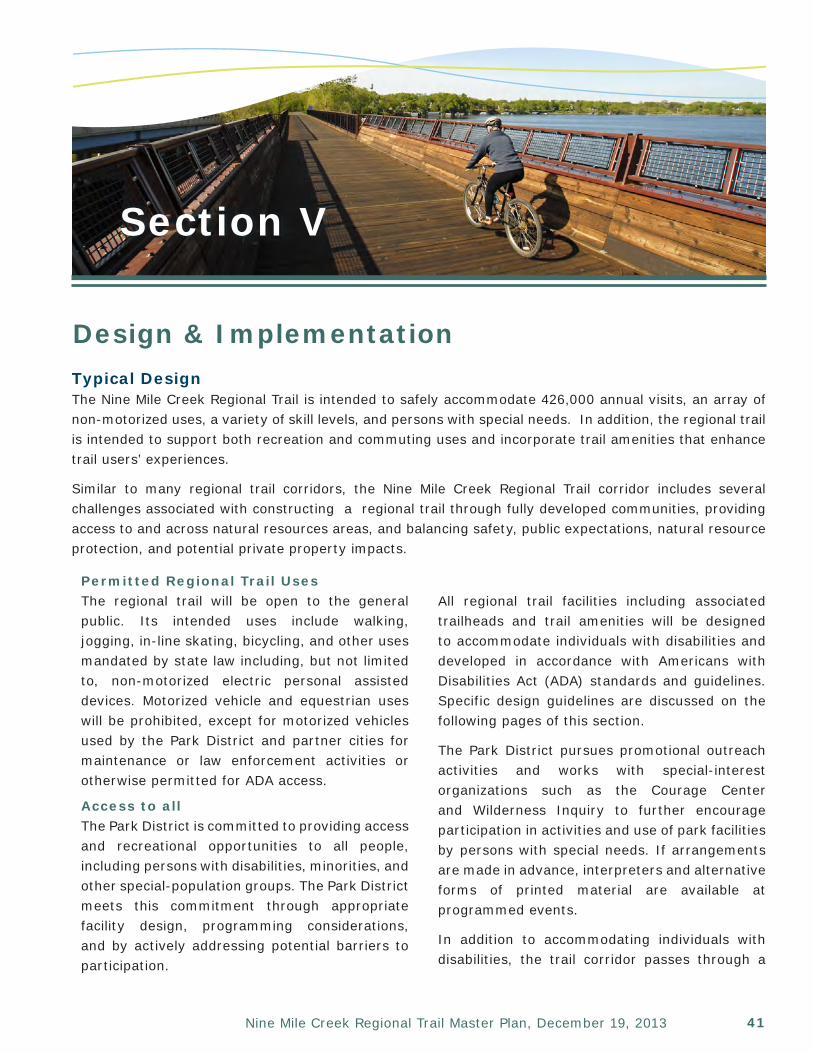
41Nine Mile Creek Regional Trail Master Plan, December 19, 2013
Section V
Design & ImplementationTypical Design The Nine Mile Creek Regional Trail is intended to safely accommodate 426,000 annual visits, an array of non-motorized uses, a variety of skill levels, and persons with special needs. In addition, the regional trail is intended to support both recreation and commuting uses and incorporate trail amenities that enhance trail users’ experiences.
Similar to many regional trail corridors, the Nine Mile Creek Regional Trail corridor includes several challenges associated with constructing a regional trail through fully developed communities, providing access to and across natural resources areas, and balancing safety, public expectations, natural resource protection, and potential private property impacts.
Permitted Regional Trail UsesThe regional trail will be open to the general public. Its intended uses include walking, jogging, in-line skating, bicycling, and other uses mandated by state law including, but not limited to, non-motorized electric personal assisted devices. Motorized vehicle and equestrian uses will be prohibited, except for motorized vehicles used by the Park District and partner cities for maintenance or law enforcement activities or otherwise permitted for ADA access.
Access to all The Park District is committed to providing access and recreational opportunities to all people, including persons with disabilities, minorities, and other special-population groups. The Park District meets this commitment through appropriate facility design, programming considerations, and by actively addressing potential barriers to participation.
All regional trail facilities including associated trailheads and trail amenities will be designed to accommodate individuals with disabilities and developed in accordance with Americans with Disabilities Act (ADA) standards and guidelines. Specific design guidelines are discussed on the following pages of this section.
The Park District pursues promotional outreach activities and works with special-interest organizations such as the Courage Center and Wilderness Inquiry to further encourage participation in activities and use of park facilities by persons with special needs. If arrangements are made in advance, interpreters and alternative forms of printed material are available at programmed events.
In addition to accommodating individuals with disabilities, the trail corridor passes through a
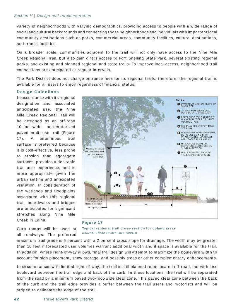
Three Rivers Park District42
Section V | Design and Implementation
variety of neighborhoods with varying demographics, providing access to people with a wide range of social and cultural backgrounds and connecting those neighborhoods and individuals with important local community destinations such as parks, commercial areas, community facilities, cultural destinations, and transit facilities.
On a broader scale, communities adjacent to the trail will not only have access to the Nine Mile Creek Regional Trail, but also gain direct access to Fort Snelling State Park, several existing regional parks, and existing and planned regional and state trails. To improve local access, neighborhood trail connections are anticipated at regular intervals.
The Park District does not charge entrance fees for its regional trails; therefore, the regional trail is available for all users to enjoy regardless of financial status.
Design GuidelinesIn accordance with its regional designation and associated anticipated use, the Nine Mile Creek Regional Trail will be designed as an off-road 10-foot-wide, non-motorized paved multi-use trail (Figure 17). A bituminous trail surface is preferred because it is cost-effective, less prone to erosion than aggregate surfaces, provides a desirable trail user experience, and is more appropriate given the urban setting and anticipated visitation. In consideration of the wetlands and floodplains associated with this regional trail, boardwalks and bridges are anticipated for significant stretches along Nine Mile Creek in Edina.
Curb ramps will be used at all roadways. The preferred maximum trail grade is 5 percent with a 2 percent cross slope for drainage. The width may be greater than 10 feet if forecasted user volumes warrant additional width and if space is available for the trail. In addition, where right-of-way allows, final trail design will attempt to maximize the boulevard width to account for sign placement, snow storage, and possibly trees or other complementary enhancements.
In circumstances with limited right-of-way, the trail is still planned to be located off-road, but with less boulevard between the trail edge and back of the curb. In these locations, the trail will be separated from the road by a minimum paved two-foot-wide clear zone. This paved clear zone between the back of the curb and the trail edge provides a buffer between the trail users and motorists and will be striped to delineate the edge of the trail.
Figure 17Typical regional trail cross-section for upland areasSource: Three Rivers Park District
43Nine Mile Creek Regional Trail Master Plan, December 19, 2013
Section V | Design and Implementation
In the event there are instances where the trail will not initially meet the preferred design, trail designers will evaluate a wide variety of design tools to determine the best fit for the unique situation. Unless the alternative trail design is an acceptable long range solution, it is anticipated that noncompliant trail segments would be improved as funding, right-of-way, or other opportunities present themselves.
A number of factors will be considered during the design phase, such as:
• Right-of-way width/acquisition needs• Topography and drainage impacts• Existing vegetation• Driveway/road crossings• Overhead and subsurface utilities• Proximity to adjacent buildings, homes,
businesses, and industrial facilities• Wetlands/floodplain locations, potential
impacts, and rules • Wildlife (species, nesting/breeding areas and
times, concentrations)• Existing infrastructure• Connectivity with other trail/sidewalk/bicycle
facilities • Safety• Cost• Obstructions• Trail user preferences/desired trail user
experience• Opportunities to coordinate with other
projects/agencies
In addition to the discussed design considerations, regional trail segments will be designed in accordance with all applicable federal, state, and local codes. More specifically, the following sources will be referred and adhered to when preparing the design and construction plans as appropriate:
•Guide for the Development of Bicycle Facilities, prepared by the American Association of State Highway and Transportation Officials (AASHTO), 1999
•Selecting Roadway Design Treatments to Accommodate Bicycles, Federal Highway Administration, January 1994
•MnDOT Bikeway Facility Design Manual, Minnesota Department of Transportation (MnDOT), March 2007
•State Aid Rule 8820.9995 Minimum Bicycle Path Standards, State Aid for Local Transportation
•Trail Planning, Design, and Development Guidelines, Minnesota Department of Natural Resources (MnDNR)
•Manual on Uniform Traffic Control Devices (MUTCD), MnDOT, May 2005
• Public Right-of-way Access Guidelines (PROWAG)
•Best Practices for Traffic Control at Regional Trail Crossings, A collaborative effort of Twin Cities road and trail managing agencies, July 2011
•Bicycle and Pedestrian Wayfinding, Metropolitan Council, October 2011
•Designing Sidewalks and Trails for Access, Part I and II: Best Practices Design Guide (FHWA); ADA Accessibility Guidelines for Outdoor Developed Areas (United States Access Board); and ADA and ABA Accessibility Guidelines for Buildings and Facilities (U.S. Access Board)
Throughout the design process of Nine Mile Creek Regional Trail, the implementing agency will work closely with the local community to design the trail in a manner that has the greatest public benefit and least amount of private property impacts. The implementing agency and local city/agency will approve the final regional trail design prior to development.
Additional Trail ElementsTrail identity, crossings, wayfinding, traffic signage and devices, rest stops, drainage, and trailheads are important elements of regional trails. Their proper design and placement add both aesthetic and functional value to the trail.
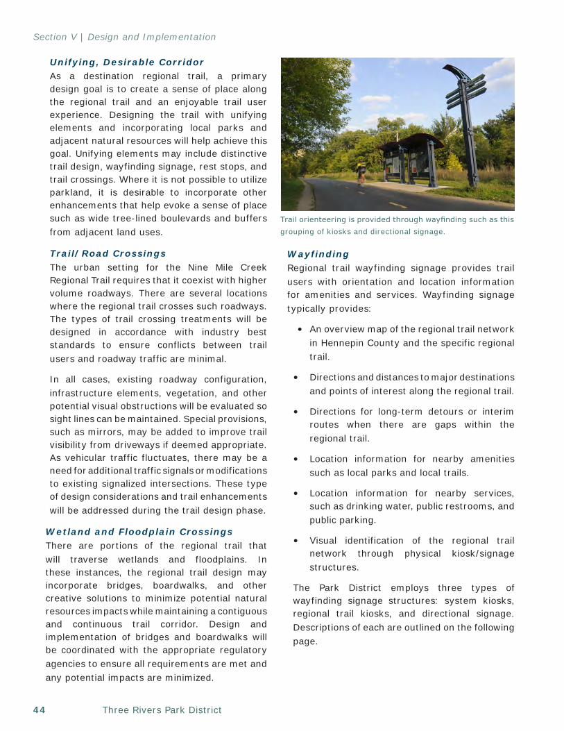
Three Rivers Park District44
Section V | Design and Implementation
Unifying, Desirable CorridorAs a destination regional trail, a primary design goal is to create a sense of place along the regional trail and an enjoyable trail user experience. Designing the trail with unifying elements and incorporating local parks and adjacent natural resources will help achieve this goal. Unifying elements may include distinctive trail design, wayfinding signage, rest stops, and trail crossings. Where it is not possible to utilize parkland, it is desirable to incorporate other enhancements that help evoke a sense of place such as wide tree-lined boulevards and buffers from adjacent land uses.
Trail/Road CrossingsThe urban setting for the Nine Mile Creek Regional Trail requires that it coexist with higher volume roadways. There are several locations where the regional trail crosses such roadways. The types of trail crossing treatments will be designed in accordance with industry best standards to ensure conflicts between trail users and roadway traffic are minimal.
In all cases, existing roadway configuration, infrastructure elements, vegetation, and other potential visual obstructions will be evaluated so sight lines can be maintained. Special provisions, such as mirrors, may be added to improve trail visibility from driveways if deemed appropriate. As vehicular traffic fluctuates, there may be a need for additional traffic signals or modifications to existing signalized intersections. These type of design considerations and trail enhancements will be addressed during the trail design phase.
Wetland and Floodplain CrossingsThere are portions of the regional trail that will traverse wetlands and floodplains. In these instances, the regional trail design may incorporate bridges, boardwalks, and other creative solutions to minimize potential natural resources impacts while maintaining a contiguous and continuous trail corridor. Design and implementation of bridges and boardwalks will be coordinated with the appropriate regulatory agencies to ensure all requirements are met and any potential impacts are minimized.
WayfindingRegional trail wayfinding signage provides trail users with orientation and location information for amenities and services. Wayfinding signage typically provides:
• An overview map of the regional trail network in Hennepin County and the specific regional trail.
• Directions and distances to major destinations and points of interest along the regional trail.
• Directions for long-term detours or interim routes when there are gaps within the regional trail.
• Location information for nearby amenities such as local parks and local trails.
• Location information for nearby services, such as drinking water, public restrooms, and public parking.
• Visual identification of the regional trail network through physical kiosk/signage structures.
The Park District employs three types of wayfinding signage structures: system kiosks, regional trail kiosks, and directional signage. Descriptions of each are outlined on the following page.
Trail orienteering is provided through wayfinding such as this grouping of kiosks and directional signage.
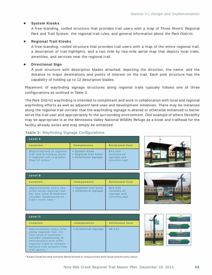
45Nine Mile Creek Regional Trail Master Plan, December 19, 2013
Section V | Design and Implementation
• System KiosksA free-standing, roofed structure that provides trail users with a map of Three Rivers’ Regional Park and Trail System, the regional trail rules, and general information about the Park District.
• Regional Trail KiosksA free-standing, roofed structure that provides trail users with a map of the entire regional trail, a description of trail highlights, and a two mile by two-mile aerial map that depicts local trails, amenities, and services near the regional trail.
• Directional SignA post structure with description blades attached, depicting the direction, the name, and the distance to major destinations and points of interest on the trail. Each post structure has the capability of holding up to 12 description blades.
Placement of wayfinding signage structures along regional trails typically follows one of three configurations as outlined in Table 3.
The Park District wayfinding is intended to compliment and work in collaboration with local and regional wayfinding efforts as well as adjacent land uses and development initiatives. There may be instances along the regional trail corridor that the wayfinding signage is altered or otherwise enhanced to better serve the trail user and appropriately fit the surrounding environment. One example of where flexibility may be appropriate is at the Minnesota Valley National Wildlife Refuge as a kiosk and trailhead for the facility already exists and may simply be enhanced.
Level A
Location Components Estimated Cost
Beginning/end of regional trail and at halfway point if regional trail is greater than 10 miles.*
• System kiosk• Regional trail kiosk• Directional signage
$43,054Includes all signage and concrete pad.
Level B
Location Components Estimated Cost
Approximately every two miles along regional trail. For new Level B locations, consider establishing on trail’s north side.*
• Regional trail kiosk• Directional signage
$26,626Includes all signage and concrete pad.
Level C
Location Components Estimated Cost
Approximately every mile along regional trail. For new Level C locations, consider establishing at intersections with other regional trails or compre-hensive trail systems (not trail spurs).*
• Directional signage $6,232
*Exact location and content determined in conjunction with local community input.
Table 3: Wayfinding Signage Configurations
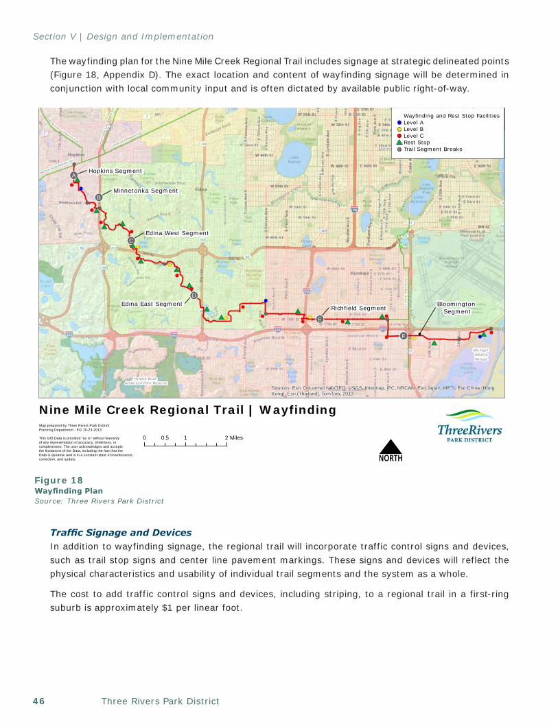
Three Rivers Park District46
Section V | Design and Implementation
The wayfinding plan for the Nine Mile Creek Regional Trail includes signage at strategic delineated points (Figure 18, Appendix D). The exact location and content of wayfinding signage will be determined in conjunction with local community input and is often dictated by available public right-of-way.
Traffic Signage and DevicesIn addition to wayfinding signage, the regional trail will incorporate traffic control signs and devices, such as trail stop signs and center line pavement markings. These signs and devices will reflect the physical characteristics and usability of individual trail segments and the system as a whole.
The cost to add traffic control signs and devices, including striping, to a regional trail in a first-ring suburb is approximately $1 per linear foot.
Minneapolis
!(
!(
!(
!(
!(
!(
Cedar Lake Regional Trail
LakeM
innetonka Regional Trail
[Inte
rcity]
Reg
ional
Trai
l
Hopkins Segment!!A
Minnetonka Segment
Edina West Segment
Edina East SegmentRichfield Segment
!!E
!!B
!!C
!!D
!!F
Hyland Bush Anderson Park Reserve
!(
!(
MN Nat'l WildlifeRefuge
MN River Bluffs Regional Tra
il
Bloomington Segment
!(
#*
!(
!(
!(!(
!(
!(
!(!(
!(
!(!(
!(
!(
!(
!(
!(
!(
!(
!(
!(#*
#*
#*
#*
#*
#*#*
#*
#*
#*#*
#*
#*
#*
!(
Nor
thCed
arLa
keReg
iona
l Tra
il
Sources: Esri, DeLorme, NAVTEQ, USGS, Intermap, iPC, NRCAN, Esri Japan, METI, Esri China (HongKong), Esri (Thailand), TomTom, 2013
0 1 20.5 Miles
Nine Mile Creek Regional Trail | Wayfinding
NMap prepared by Three Rivers Park DistrictPlanning Department - KG 10-23-2013
This GIS Data is provided "as is" without warranty of any representation of accuracy, timeliness, or completeness. The user acknowledges and acceptsthe limitations of the Data, including the fact that the Data is dynamic and is in a constant state of maintenance,correction, and update.
Wayfinding and Rest Stop FacilitiesLevel ALevel BLevel CRest StopTrail Segment Breaks
Figure 18Wayfinding PlanSource: Three Rivers Park District
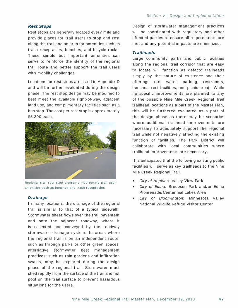
47Nine Mile Creek Regional Trail Master Plan, December 19, 2013
Section V | Design and Implementation
Rest StopsRest stops are generally located every mile and provide places for trail users to stop and rest along the trail and an area for amenities such as trash receptacles, benches, and bicycle racks. These simple but important amenities can serve to reinforce the identity of the regional trail route and better support the trail users with mobility challenges.
Locations for rest stops are listed in Appendix D and will be further evaluated during the design phase. The rest stop design may be modified to best meet the available right-of-way, adjacent land use, and complimentary facilities such as a bus stop. The cost per rest stop is approximately $5,300 each.
DrainageIn many locations, the drainage of the regional trail is similar to that of a typical sidewalk. Stormwater sheet flows over the trail pavement and onto the adjacent roadway, where it is collected and conveyed by the roadway stormwater drainage system. In areas where the regional trail is on an independent route, such as through parks or other green spaces, alternative stormwater best management practices, such as rain gardens and infiltration swales, may be explored during the design phase of the regional trail. Stormwater must shed rapidly from the surface of the trail and not pool on the trail surface to prevent hazardous situations for the users.
Regional trail rest stop elements incorporate trail user amenities such as benches and trash receptacles.
Design of stormwater management practices will be coordinated with regulatory and other affected parties to ensure all requirements are met and any potential impacts are minimized.
TrailheadsLarge community parks and public facilities along the regional trail corridor that are easy to locate will function as defacto trailheads simply by the nature of existence and their offerings (i.e. water, parking, restrooms, benches, rest facilities, and picnic area). While no specific improvements are planned to any of the possible Nine Mile Creek Regional Trail trailhead locations as a part of the Master Plan, this will be furthered evaluated as a part of the design phase as there may be scenarios where additional trailhead improvements are necessary to adequately support the regional trail while not negatively affecting the existing function of facilities. The Park District will collaborate with local communities where trailhead improvements are necessary.
It is anticipated that the following existing public facilities will serve as key trailheads to the Nine Mile Creek Regional Trail.
• City of Hopkins: Valley View Park• City of Edina: Bredesen Park and/or Edina
Promenade/Centennial Lakes Area • City of Bloomington: Minnesota Valley
National Wildlife Refuge Visitor Center
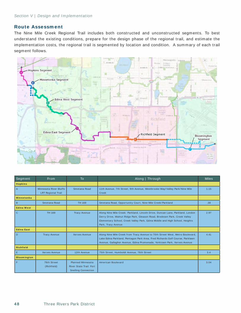
Three Rivers Park District48
Section V | Design and Implementation
0 1 20.5 Miles
Nine Mile Creek Regional Trail | Segment Divisions
NMap prepared by Three Rivers Park DistrictPlanning Department - KG September 10, 2013
This GIS Data is provided "as is" without warranty of any representation of accuracy, timeliness, or completeness. The user acknowledges and acceptsthe limitations of the Data, including the fact that the Data is dynamic and is in a constant state of maintenance,correction, and update.
!!!!
! !
!!
!!
! !
!!!!!!!! !!
!!!!!!!!
!
!!!!
! ! ! ! ! ! !! !!
! ! ! ! ! ! ! !
!
!!
!!
Route Assessment The Nine Mile Creek Regional Trail includes both constructed and unconstructed segments. To best understand the existing conditions, prepare for the design phase of the regional trail, and estimate the implementation costs, the regional trail is segmented by location and condition. A summary of each trail segment follows.
Segment From To Along | Through MilesHopkins
A Minnesota River Bluffs LRT Regional Trail
Smetana Road 11th Avenue, 7th Street, 9th Avenue, Westbrooke Way/Valley Park/Nine Mile Creek
1.15
Minnetonka
B Smetana Road TH 169 Smetana Road, Opportunity Court, Nine Mile Creek/Parkland .38
Edina West
C TH 169 Tracy Avenue Along Nine Mile Creek: Parkland, Lincoln Drive, Duncan Lane, Parkland, London Derry Drive, Walnut Ridge Park, Gleason Road, Bredesen Park, Creek Valley Elementary School, Creek Valley Park, Edina Middle and High School, Heights Park, Tracy Avenue
2.97
Edina East
D Tracy Avenue Xerxes Avenue Along Nine Mile Creek from Tracy Avenue to 70th Street West, Metro Boulevard, Lake Edina Parkland, Pentagon Park Area, Fred Richards Golf Course, Parklawn Avenue, Gallagher Avenue, Edina Promenade, Yorktown Park, Xerxes Avenue
4.41
Richfield
E Xerxes Avenue 12th Avenue 75th Street, Humboldt Avenue, 76th Street 3.4
Bloomington
F 76th Street(Richfield)
Planned Minnesota River State Trail: Fort Snelling Connection
American Boulevard 3.04
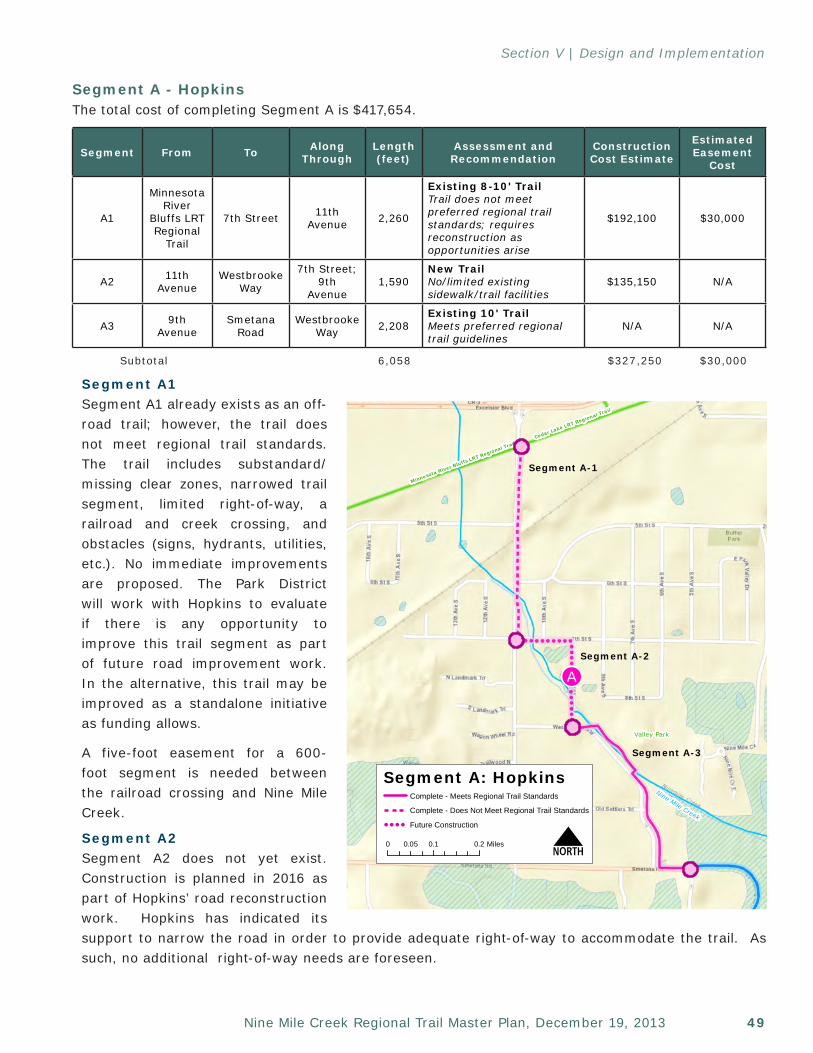
49Nine Mile Creek Regional Trail Master Plan, December 19, 2013
Section V | Design and Implementation
Segment A1Segment A1 already exists as an off-road trail; however, the trail does not meet regional trail standards. The trail includes substandard/missing clear zones, narrowed trail segment, limited right-of-way, a railroad and creek crossing, and obstacles (signs, hydrants, utilities, etc.). No immediate improvements are proposed. The Park District will work with Hopkins to evaluate if there is any opportunity to improve this trail segment as part of future road improvement work. In the alternative, this trail may be improved as a standalone initiative as funding allows.
A five-foot easement for a 600-foot segment is needed between the railroad crossing and Nine Mile Creek.
Segment A2Segment A2 does not yet exist. Construction is planned in 2016 as part of Hopkins’ road reconstruction work. Hopkins has indicated its support to narrow the road in order to provide adequate right-of-way to accommodate the trail. As such, no additional right-of-way needs are foreseen.
Segment A - HopkinsThe total cost of completing Segment A is $417,654.
Segment From To Along Through
Length (feet)
Assessment and Recommendation
Construction Cost Estimate
Estimated Easement
Cost
A1
Minnesota River
Bluffs LRT Regional
Trail
7th Street 11th Avenue 2,260
Existing 8-10' Trail Trail does not meet preferred regional trail standards; requires reconstruction as opportunities arise
$192,100 $30,000
A2 11thAvenue
Westbrooke Way
7th Street; 9th
Avenue1,590
New Trail No/limited existing sidewalk/trail facilities
$135,150 N/A
A3 9thAvenue
Smetana Road
Westbrooke Way 2,208
Existing 10' Trail Meets preferred regional trail guidelines
N/A N/A
Subtotal 6,058 $327,250 $30,000
!!A
Minnesota River Bluffs LRT Regional TrailCedar Lake LRT Regional Trail
Valley Park
Sources: Esri, DeLorme, NAVTEQ, USGS, Intermap, iPC, NRCAN, Esri Japan,METI, Esri China (Hong Kong), Esri (Thailand), TomTom, 2013
Map prepared by Three Rivers Park DistrictPlanning Department - AR August 23, 2013
This GIS Data is provided "as is" without warranty of any representation of accuracy, timeliness, or completeness. The user acknowledges and acceptsthe limitations of the Data, including the fact that the Data is dynamic and is in a constant state of maintenance,correction, and update.
Nine Mile Creek
Segment A-1
Segment A-2
Segment A-3
Segment A: Hopkins
0 0.1 0.20.05 Miles N
Complete - Meets Regional Trail Standards
Complete - Does Not Meet Regional Trail Standards
! ! ! ! Future Construction
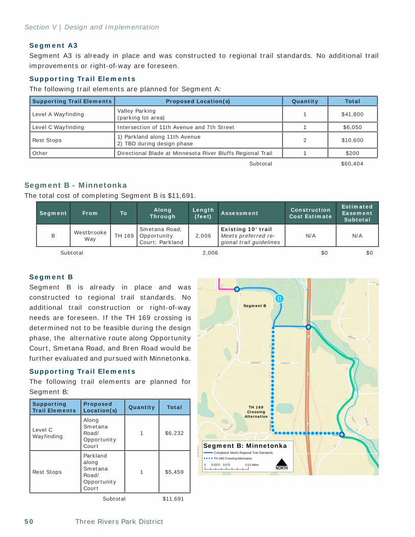
Three Rivers Park District50
Section V | Design and Implementation
Segment A3Segment A3 is already in place and was constructed to regional trail standards. No additional trail improvements or right-of-way are foreseen.
Supporting Trail ElementsThe following trail elements are planned for Segment A:
Segment B - MinnetonkaThe total cost of completing Segment B is $11,691.
Segment BSegment B is already in place and was constructed to regional trail standards. No additional trail construction or right-of-way needs are foreseen. If the TH 169 crossing is determined not to be feasible during the design phase, the alternative route along Opportunity Court, Smetana Road, and Bren Road would be further evaluated and pursued with Minnetonka.
Supporting Trail ElementsThe following trail elements are planned for Segment B:
Supporting Trail Elements Proposed Location(s) Quantity Total
Level A Wayfinding Valley Parking (parking lot area) 1 $41,800
Level C Wayfinding Intersection of 11th Avenue and 7th Street 1 $6,050
Rest Stops 1) Parkland along 11th Avenue 2) TBD during design phase 2 $10,600
Other Directional Blade at Minnesota River Bluffs Regional Trail 1 $200
Subtotal $60,404
!!
!!
!!
!!
!!
!!
!!
!!
!!
!!
!!
!!
!!
! ! ! ! ! ! ! ! ! ! ! ! ! ! ! !
!!B
!(
NineMile
Creek
Sources: Esri, DeLorme, NAVTEQ, USGS, Intermap, iPC, NRCAN, Esri Japan,METI, Esri China (Hong Kong), Esri (Thailand), TomTom, 2013
Nine Mile Creek Regional Trail | Minnetonka
NMap prepared by Three Rivers Park DistrictPlanning Department - AR August 23, 2013
This GIS Data is provided "as is" without warranty of any representation of accuracy, timeliness, or completeness. The user acknowledges and acceptsthe limitations of the Data, including the fact that the Data is dynamic and is in a constant state of maintenance,correction, and update.
Segment B: Minnetonka
N0 0.075 0.150.0375 Miles
Segment B
TH 169Crossing
Alternative
Completed: Meets Regional Trail Standards
! ! ! ! TH 169 Crossing Alternative
Segment From To Along Through
Length (feet) Assessment Construction
Cost Estimate
EstimatedEasement Subtotal
B Westbrooke Way TH 169
Smetana Road; Opportunity Court; Parkland
2,006Existing 10' trail Meets preferred re-gional trail guidelines
N/A N/A
Subtotal 2,006 $0 $0
Supporting Trail Elements
Proposed Location(s) Quantity Total
Level C Wayfinding
Along Smetana Road/Opportunity Court
1 $6,232
Rest Stops
Parkland along Smetana Road/Opportunity Court
1 $5,459
Subtotal $11,691
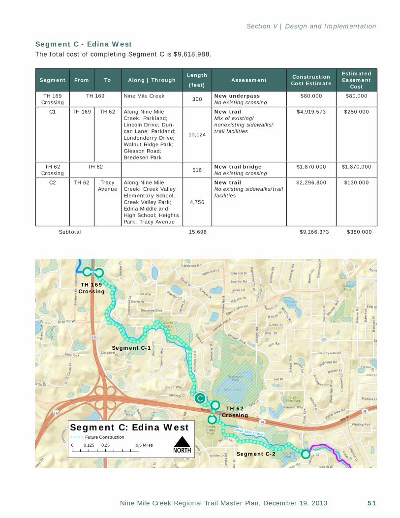
51Nine Mile Creek Regional Trail Master Plan, December 19, 2013
Section V | Design and Implementation
Segment From To Along Through
Length (feet) Assessment Construction
Cost Estimate
EstimatedEasement Subtotal
B Westbrooke Way TH 169
Smetana Road; Opportunity Court; Parkland
2,006Existing 10' trail Meets preferred re-gional trail guidelines
N/A N/A
Subtotal 2,006 $0 $0
Segment C - Edina WestThe total cost of completing Segment C is $9,618,988.
!(
!!C
Valley Park
Sources: Esri, DeLorme, NAVTEQ, USGS, Intermap, iPC, NRCAN, Esri Japan, METI, Esri China (HongKong), Esri (Thailand), TomTom, 2013
Nine Mile Creek Regional Trail | Edina West
NMap prepared by Three Rivers Park DistrictPlanning Department - AR August 23, 2013
This GIS Data is provided "as is" without warranty of any representation of accuracy, timeliness, or completeness. The user acknowledges and acceptsthe limitations of the Data, including the fact that the Data is dynamic and is in a constant state of maintenance,correction, and update.
Nine Mile CreekSegment C: Edina West
N0 0.25 0.50.125 Miles
TH 169Crossing
Segment C-1
TH 62Crossing
Segment C-2
!!
! ! ! ! Future Construction
! !
Segment From To Along | ThroughLength
(feet)Assessment Construction
Cost Estimate
Estimated Easement
Cost
TH 169 Crossing
TH 169 Nine Mile Creek 300 New underpass No existing crossing
$80,000 $80,000
C1 TH 169 TH 62 Along Nine Mile Creek: Parkland; Lincoln Drive; Dun-can Lane; Parkland; Londonderry Drive; Walnut Ridge Park; Gleason Road; Bredesen Park
10,124
New trail Mix of existing/nonexisting sidewalks/trail facilities
$4,919,573 $250,000
TH 62 Crossing
TH 62 516 New trail bridge No existing crossing
$1,870,000 $1,870,000
C2 TH 62 Tracy Avenue
Along Nine Mile Creek: Creek Valley Elementary School, Creek Valley Park; Edina Middle and High School; Heights Park; Tracy Avenue
4,756
New trail No existing sidewalks/trail facilities
$2,296,800 $130,000
Subtotal 15,696 $9,166,373 $380,000
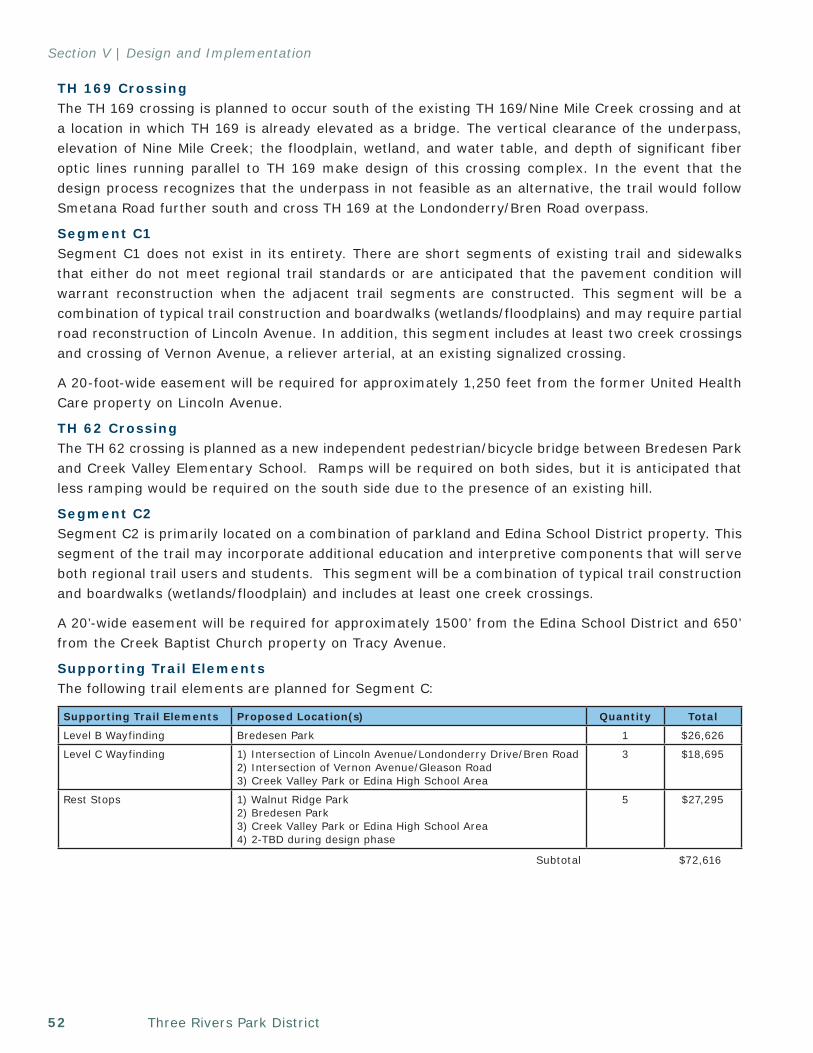
Three Rivers Park District52
Section V | Design and Implementation
TH 169 CrossingThe TH 169 crossing is planned to occur south of the existing TH 169/Nine Mile Creek crossing and at a location in which TH 169 is already elevated as a bridge. The vertical clearance of the underpass, elevation of Nine Mile Creek; the floodplain, wetland, and water table, and depth of significant fiber optic lines running parallel to TH 169 make design of this crossing complex. In the event that the design process recognizes that the underpass in not feasible as an alternative, the trail would follow Smetana Road further south and cross TH 169 at the Londonderry/Bren Road overpass.
Segment C1Segment C1 does not exist in its entirety. There are short segments of existing trail and sidewalks that either do not meet regional trail standards or are anticipated that the pavement condition will warrant reconstruction when the adjacent trail segments are constructed. This segment will be a combination of typical trail construction and boardwalks (wetlands/floodplains) and may require partial road reconstruction of Lincoln Avenue. In addition, this segment includes at least two creek crossings and crossing of Vernon Avenue, a reliever arterial, at an existing signalized crossing.
A 20-foot-wide easement will be required for approximately 1,250 feet from the former United Health Care property on Lincoln Avenue.
TH 62 CrossingThe TH 62 crossing is planned as a new independent pedestrian/bicycle bridge between Bredesen Park and Creek Valley Elementary School. Ramps will be required on both sides, but it is anticipated that less ramping would be required on the south side due to the presence of an existing hill.
Segment C2Segment C2 is primarily located on a combination of parkland and Edina School District property. This segment of the trail may incorporate additional education and interpretive components that will serve both regional trail users and students. This segment will be a combination of typical trail construction and boardwalks (wetlands/floodplain) and includes at least one creek crossings.
A 20’-wide easement will be required for approximately 1500’ from the Edina School District and 650’ from the Creek Baptist Church property on Tracy Avenue.
Supporting Trail ElementsThe following trail elements are planned for Segment C:
Supporting Trail Elements Proposed Location(s) Quantity Total
Level B Wayfinding Bredesen Park 1 $26,626
Level C Wayfinding 1) Intersection of Lincoln Avenue/Londonderry Drive/Bren Road 2) Intersection of Vernon Avenue/Gleason Road 3) Creek Valley Park or Edina High School Area
3 $18,695
Rest Stops 1) Walnut Ridge Park 2) Bredesen Park 3) Creek Valley Park or Edina High School Area 4) 2-TBD during design phase
5 $27,295
Subtotal $72,616
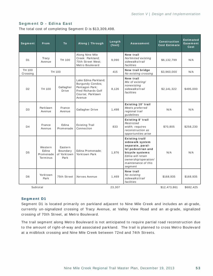
53Nine Mile Creek Regional Trail Master Plan, December 19, 2013
Section V | Design and Implementation
Segment D - Edina EastThe total cost of completing Segment D is $13,309,498.
Segment D1Segment D1 is located primarily on parkland adjacent to Nine Mile Creek and includes an at-grade, currently un-signalized crossing of Tracy Avenue, at Valley View Road and an at-grade, signalized crossing of 70th Street, at Metro Boulevard.
The trail segment along Metro Boulevard is not anticipated to require partial road reconstruction due to the amount of right-of-way and associated parkland. The trail is planned to cross Metro Boulevard at a midblock crossing and Nine Mile Creek between 72nd and 74th Streets.
Segment From To Along | Through Length (feet) Assessment Construction
Cost Estimate
EstimatedEasement
Cost
D1 Tracy Avenue TH 100
Along Nine Mile Creek: Parkland; 70th Street West; Metro Boulevard
9,090
New trail No/limited existing sidewalks/trail facilities
$6,132,799 N/A
TH 100 Crossing TH 100 415 New trail bridge
No existing crossing $3,960,000 N/A
D2 TH 100 Gallagher Drive
Lake Edina Parkland; Burgundy Condos; Pentagon Park; Fred Richards Golf Course; ParklawnAvenue
8,126
New trail Mix of existing/nonexisting sidewalks/trail facilities
$2,141,322 $495,000
D3 Parklawn Avenue
France Avenue Gallagher Drive 1,498
Existing 10’ trail Meets preferred regional trail guidelines
N/A N/A
D4 France Avenue
Edina Promenade
Existing Trail Connection 833
Existing 8’ trail Restricted width; requires reconstruction as opportunities arise
$70,805 $258,230
D5
Western Edina
Promenade Terminus
Eastern Boundary
of Yorktown Park
Edina Promenade; Yorktown Park 1,876
Existing trail/sidewalk system separate, paral-lel pedestrian and bicycle systems Edina will retain ownership/operation/maintenance of this segment
N/A N/A
D6 Yorktown Park 75th Street Xerxes Avenue 1,469
New trail No existing sidewalks/trail facilities
$168,935 $168,935
Subtotal 23,307 $12,473,861 $682,425
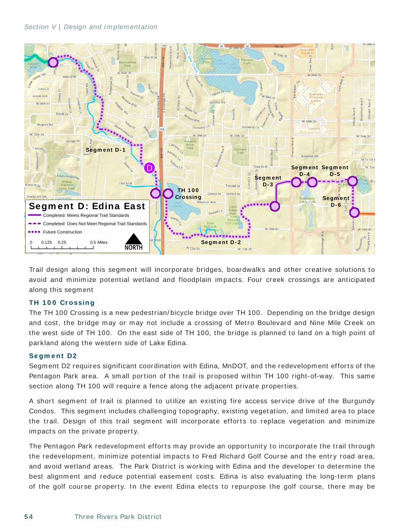
Three Rivers Park District54
Section V | Design and Implementation
Trail design along this segment will incorporate bridges, boardwalks and other creative solutions to avoid and minimize potential wetland and floodplain impacts. Four creek crossings are anticipated along this segment
TH 100 CrossingThe TH 100 Crossing is a new pedestrian/bicycle bridge over TH 100. Depending on the bridge design and cost, the bridge may or may not include a crossing of Metro Boulevard and Nine Mile Creek on the west side of TH 100. On the east side of TH 100, the bridge is planned to land on a high point of parkland along the western side of Lake Edina.
Segment D2Segment D2 requires significant coordination with Edina, MnDOT, and the redevelopment efforts of the Pentagon Park area. A small portion of the trail is proposed within TH 100 right-of-way. This same section along TH 100 will require a fence along the adjacent private properties.
A short segment of trail is planned to utilize an existing fire access service drive of the Burgundy Condos. This segment includes challenging topography, existing vegetation, and limited area to place the trail. Design of this trail segment will incorporate efforts to replace vegetation and minimize impacts on the private property.
The Pentagon Park redevelopment efforts may provide an opportunity to incorporate the trail through the redevelopment, minimize potential impacts to Fred Richard Golf Course and the entry road area, and avoid wetland areas. The Park District is working with Edina and the developer to determine the best alignment and reduce potential easement costs. Edina is also evaluating the long-term plans of the golf course property. In the event Edina elects to repurpose the golf course, there may be
!!D
Nine Mile Creek
Sources: Esri, DeLorme, NAVTEQ, USGS, Intermap, iPC, NRCAN, Esri Japan, METI, Esri China (HongKong), Esri (Thailand), TomTom, 2013
Nine Mile Creek Regional Trail | Edina East
NMap prepared by Three Rivers Park DistrictPlanning Department - AR August 23, 2013
This GIS Data is provided "as is" without warranty of any representation of accuracy, timeliness, or completeness. The user acknowledges and acceptsthe limitations of the Data, including the fact that the Data is dynamic and is in a constant state of maintenance,correction, and update.
NineM
ileCreek
Segment D: Edina East
N
TH 100Crossing
0 0.25 0.50.125 Miles
Segment D-1
Segment D-2
SegmentD-3
SegmentD-4
SegmentD-5
SegmentD-6
! !
Completed: Meets Regional Trail Standards
Completed: Does Not Meet Regional Trail Standards
! ! ! ! Future Construction
55Nine Mile Creek Regional Trail Master Plan, December 19, 2013
Section V | Design and Implementation
an opportunity to better align the regional trail through the golf course property and avoid the Fred Richard Golf Course entry road — eliminating the need for additional easement and reconfiguration of adjacent parking lots. A decision on the future of the Fred Richards Golf Course is anticipated by the end of 2013.
The trail segment along Parklawn Avenue will require partial road reconstruction and may eliminate or reduce any existing on-street parking. This segment includes crossing Gallagher Drive.
A new 20’ easement for 360 feet along the northern boundary of Burgundy Condos, 1,300 feet through Pentagon Park and 650 feet along Fred Richards Golf Course entry road may be needed depending on final route alignment.
Segment D3Segment D3 is already in place and was constructed to regional trail standards. No additional trail improvements or right-of-way are foreseen.
Segment D4 Segment D4 includes the at-grade crossing of France Avenue at an existing signal and the reconstruction of an existing 8-foot bituminous trail. Modifications to the existing trail easements are required.
Segment D5Segment D5 already exists as the Edina Promenade and Yorktown Park trail system. This trail segment will remain under Edina’s jurisdiction; as such, no improvements are proposed.
Segment D6Segment D6 is located within Xerxes Avenue right-of-way and will require partial road reconstruction and may eliminate or reduce any existing on-street parking.
Supporting Trail ElementsThe following trail elements are planned for Segment D:
Supporting Trail Elements Proposed Location(s) Quantity Total
Level A Wayfinding Edina Promenade/Yorktown Park/Adam Hill Park Area 1 $43,054
Level B Wayfinding 1) Intersection of Tracy Avenue and 65th Street 2) Fred Richards Golf Course 2 $53,251
Level C Wayfinding 1) Heights Park near existing creek crossing 2) Intersection of 70th Street and Metro Boulevard 3) France Avenue
3 $18,695
Rest Stops 1) Heights Park near existing creek crossing 2) Parkland north of 70th Street 3) Lake Edina Parkland/Fred Richards Golf Course 4) Parklawn Avenue/Fred Richards Golf Course 5) Three TBD during the Design Phase
7 $38,213
Subtotal $153,213
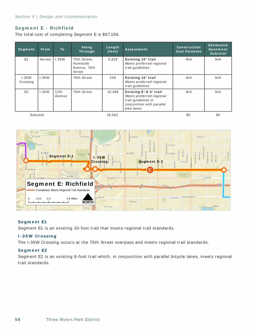
Three Rivers Park District56
Section V | Design and Implementation
Segment E - RichfieldThe total cost of completing Segment E is $67,156.
Segment E1Segment E1 is an existing 10-foot trail that meets regional trail standards.
I-35W CrossingThe I-35W Crossing occurs at the 76th Street overpass and meets regional trail standards.
Segment E2Segment E2 is an existing 8-foot trail which, in conjunction with parallel bicycle lanes, meets regional trail standards.
[In t
erci
ty]
Re g
iona
lTr a
il[I
nter
city
]R
egio
n alT
rail
Sources: Esri, DeLorme, NAVTEQ, USGS, Intermap, iPC, NRCAN, Esri Japan, METI, Esri China (HongKong), Esri (Thailand), TomTom, 2013
NMap prepared by Three Rivers Park DistrictPlanning Department - AR August 22, 2013
This GIS Data is provided "as is" without warranty of any representation of accuracy, timeliness, or completeness. The user acknowledges and acceptsthe limitations of the Data, including the fact that the Data is dynamic and is in a constant state of maintenance,correction, and update.
Nine Mile Creek Regional Trail | Richfield
!!E
Segment E: Richfield
N0 0.3 0.60.15 Miles
Segment E-1Segment E-2
I-35WCrossing
Completed: Meets Regional Trail Standards
Segment From To Along Through
Length (feet) Assessment Construction
Cost Estimate
EstimatedEasementSubtotal
E1 Xerxes I-35W 75th Street; Humboldt Avenue; 76th Street
5,818 Existing 10’ trail Meets preferred regional trail guidelines
N/A N/A
I-35W Crossing
I-35W 76th Street 246 Existing 10’ trail Meets preferred regional trail guidelines
N/A N/A
E2 I-35W 12th Avenue
76th Street 10,498 Existing 8’-8.5’ trail Meets preferred regional trail guidelines in conjunction with parallel bike lanes
N/A N/A
Subtotal 16,562 $0 $0
57Nine Mile Creek Regional Trail Master Plan, December 19, 2013
Section V | Design and Implementation
Supporting Trail ElementsThe following trail elements are planned for Segment E:
Segment F - BloomingtonThe total cost of completing Segment F is $1,907,984.
Segment From To AlongThrough
Length (feet) Assessment
Construction Cost
Estimate
Estimated Easement
Cost
F1 76th Street
Cedar Avenue
12th Avenue; American Boulevard
4,277
New Trail (share route with Intercity Regional Trail)Existing sidewalk, requires removal and reconstruction with bituminous trail
N/A – part of Intercity Regional Trail
TH 77 TH 77 American Boulevard 630
Existing 6-8’ SidewalkRestricted width; requires reconstruction as opportunities arise
$72,450 N/A
F2 Cedar Avenue
34th Avenue
American Boulevard 11,150
Existing ~8’ SidewalkRestricted width; reconstruct to meet desired 10’ width as opportunities arise
$537,795 $664,335
F3 34th Avenue
Planned Minnesota River State Trail Fort Snelling Connection
American Boulevard 4,845
Existing ~8’ SidewalkRestricted width; reconstruct to meet desired 10’ width as opportunities arise
$411,825 $117,600
Subtotal 16,079 $1,022,070 $781,935
Supporting Trail Elements Proposed Location(s) Quantity Total
Level B Wayfinding 1) Intersection of 77th/76th Street and 35W 1 $26,626
Level C Wayfinding
1) Intersection of Xerxes Avenue and 75th Street 2) Intersection of Humboldt and 76th Street 3) Around Nicollet Avenue on 76th Street 4) Intersection of 12th Avenue and 76th Street
4 $18,695
Rest Stops
1) Along 75th Street by Donaldson Park 2) Near Nicollet Avenue along 76th Street where adequate right-of-way exists 3) Near 12th Avenue along 76th Street where adequate right-of-way exists 4) 2-TBD during design phase
5 $21,836
Subtotal $67,157
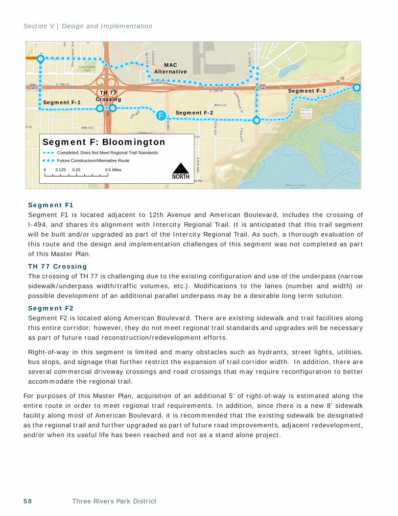
Three Rivers Park District58
Section V | Design and Implementation
Segment F1Segment F1 is located adjacent to 12th Avenue and American Boulevard, includes the crossing of I-494, and shares its alignment with Intercity Regional Trail. It is anticipated that this trail segment will be built and/or upgraded as part of the Intercity Regional Trail. As such, a thorough evaluation of this route and the design and implementation challenges of this segment was not completed as part of this Master Plan.
TH 77 CrossingThe crossing of TH 77 is challenging due to the existing configuration and use of the underpass (narrow sidewalk/underpass width/traffic volumes, etc.). Modifications to the lanes (number and width) or possible development of an additional parallel underpass may be a desirable long term solution.
Segment F2Segment F2 is located along American Boulevard. There are existing sidewalk and trail facilities along this entire corridor; however, they do not meet regional trail standards and upgrades will be necessary as part of future road reconstruction/redevelopment efforts.
Right-of-way in this segment is limited and many obstacles such as hydrants, street lights, utilities, bus stops, and signage that further restrict the expansion of trail corridor width. In addition, there are several commercial driveway crossings and road crossings that may require reconfiguration to better accommodate the regional trail.
For purposes of this Master Plan, acquisition of an additional 5’ of right-of-way is estimated along the entire route in order to meet regional trail requirements. In addition, since there is a new 8’ sidewalk facility along most of American Boulevard, it is recommended that the existing sidewalk be designated as the regional trail and further upgraded as part of future road improvements, adjacent redevelopment, and/or when its useful life has been reached and not as a stand alone project.
!!
!!
!!
!!!
!!
!!
! ! ! ! ! ! ! ! ! ! ! !!
! ! ! !! ! ! ! !
!!
! ! ! ! ! ! ! ! ! ! ! ! ! ! ! ! !!
!
!!
!
!!
!!
!!
!!
!!
MN Nat'l WildlifeRefuge!!F
[Int
erci
ty]
Regi
onal
Trai
l
Sources: Esri, DeLorme, NAVTEQ, USGS, Intermap, iPC, NRCAN, Esri Japan, METI, Esri China (HongKong), Esri (Thailand), TomTom, 2013
NMap prepared by Three Rivers Park DistrictPlanning Department - AR August 22, 2013
This GIS Data is provided "as is" without warranty of any representation of accuracy, timeliness, or completeness. The user acknowledges and acceptsthe limitations of the Data, including the fact that the Data is dynamic and is in a constant state of maintenance,correction, and update.
Nine Mile Creek Regional Trail | MAC/Bloomington Options
Segment F: Bloomington
N0 0.25 0.50.125 Miles
Segment F-1
Segment F-2
Segment F-3TH 77Crossing
MACAlternative
Completed: Does Not Meet Regional Trail Standards
! ! ! Future Construction/Alternative Route
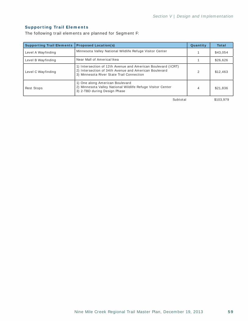
59Nine Mile Creek Regional Trail Master Plan, December 19, 2013
Section V | Design and Implementation
Supporting Trail ElementsThe following trail elements are planned for Segment F:
Supporting Trail Elements Proposed Location(s) Quantity Total
Level A Wayfinding Minnesota Valley National Wildlife Refuge Visitor Center 1 $43,054
Level B Wayfinding Near Mall of America/Ikea 1 $26,626
Level C Wayfinding1) Intersection of 12th Avenue and American Boulevard (ICRT)2) Intersection of 34th Avenue and American Boulevard3) Minnesota River State Trail Connection
2 $12,463
Rest Stops1) One along American Boulevard2) Minnesota Valley National Wildlife Refuge Visitor Center3) 2-TBD during Design Phase
4 $21,836
Subtotal $103,979
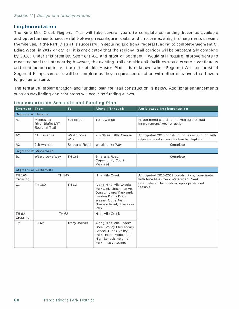
Three Rivers Park District60
Section V | Design and Implementation
Implementation The Nine Mile Creek Regional Trail will take several years to complete as funding becomes available and opportunities to secure right-of-way, reconfigure roads, and improve existing trail segments present themselves. If the Park District is successful in securing additional federal funding to complete Segment C: Edina West, in 2017 or earlier; it is anticipated that the regional trail corridor will be substantially complete by 2018. Under this premise, Segment A-1 and most of Segment F would still require improvements to meet regional trail standards; however, the existing trail and sidewalk facilities would create a continuous and contiguous route. At the date of this Master Plan it is unknown when Segment A-1 and most of Segment F improvements will be complete as they require coordination with other initiatives that have a longer time frame.
The tentative implementation and funding plan for trail construction is below. Additional enhancements such as wayfinding and rest stops will occur as funding allows.
Implementation Schedule and Funding Plan Segment From To Along | Through Anticipated Implementation
Segment A: Hopkins
A1 Minnesota River Bluffs LRT Regional Trail
7th Street 11th Avenue Recommend coordinating with future road improvement/reconstruction
A2 11th Avenue Westbrooke Way
7th Street; 9th Avenue Anticipated 2016 construction in conjunction with adjacent road reconstruction by Hopkins
A3 9th Avenue Smetana Road Westbrooke Way Complete
Segment B: Minnetonka
B1 Westbrooke Way TH 169 Smetana Road; Opportunity Court; Parkland
Complete
Segment C: Edina West
TH 169 Crossing
TH 169 Nine Mile Creek Anticipated 2015-2017 construction; coordinate with Nine Mile Creek Watershed Creek restoration efforts where appropriate and feasible
C1 TH 169 TH 62 Along Nine Mile Creek: Parkland; Lincoln Drive; Duncan Lane; Parkland; London Derry Drive; Walnut Ridge Park; Gleason Road; Bredesen Park
TH 62 Crossing
TH 62 Nine Mile Creek
C2 TH 62 Tracy Avenue Along Nine Mile Creek: Creek Valley Elementary School, Creek Valley Park; Edina Middle and High School; Heights Park; Tracy Avenue
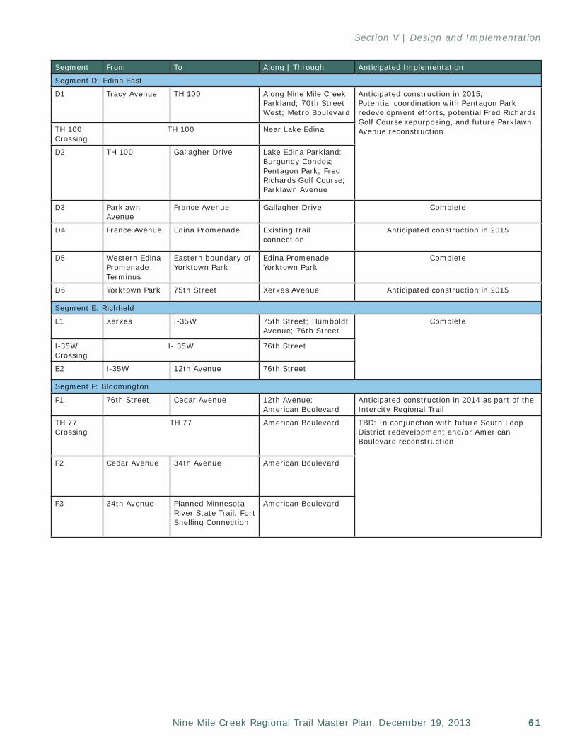
61Nine Mile Creek Regional Trail Master Plan, December 19, 2013
Section V | Design and Implementation
Segment From To Along | Through Anticipated Implementation
Segment D: Edina East
D1 Tracy Avenue TH 100 Along Nine Mile Creek: Parkland; 70th Street West; Metro Boulevard
Anticipated construction in 2015; Potential coordination with Pentagon Park redevelopment efforts, potential Fred Richards Golf Course repurposing, and future Parklawn Avenue reconstructionTH 100
CrossingTH 100 Near Lake Edina
D2 TH 100 Gallagher Drive Lake Edina Parkland; Burgundy Condos; Pentagon Park; Fred Richards Golf Course; Parklawn Avenue
D3 Parklawn Avenue
France Avenue Gallagher Drive Complete
D4 France Avenue Edina Promenade Existing trail connection
Anticipated construction in 2015
D5 Western Edina Promenade Terminus
Eastern boundary of Yorktown Park
Edina Promenade; Yorktown Park
Complete
D6 Yorktown Park 75th Street Xerxes Avenue Anticipated construction in 2015
Segment E: Richfield
E1 Xerxes I-35W 75th Street; Humboldt Avenue; 76th Street
Complete
I-35W Crossing
I- 35W 76th Street
E2 I-35W 12th Avenue 76th Street
Segment F: Bloomington
F1 76th Street Cedar Avenue 12th Avenue; American Boulevard
Anticipated construction in 2014 as part of the Intercity Regional Trail
TH 77 Crossing
TH 77 American Boulevard TBD: In conjunction with future South Loop District redevelopment and/or American Boulevard reconstruction
F2 Cedar Avenue 34th Avenue American Boulevard
F3 34th Avenue Planned Minnesota River State Trail: Fort Snelling Connection
American Boulevard

Three Rivers Park District62
Section V | Design and Implementation
This page left intentionally blank
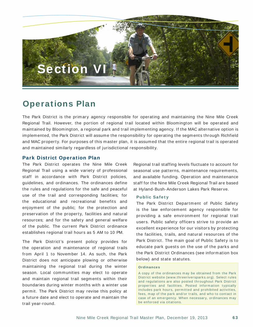
63Nine Mile Creek Regional Trail Master Plan, December 19, 2013
Section VI
Operations PlanThe Park District is the primary agency responsible for operating and maintaining the Nine Mile Creek Regional Trail. However, the portion of regional trail located within Bloomington will be operated and maintained by Bloomington, a regional park and trail implementing agency. If the MAC alternative option is implemented, the Park District will assume the responsibility for operating the segments through Richfield and MAC property. For purposes of this master plan, it is assumed that the entire regional trail is operated and maintained similarly regardless of jurisdictional responsibility.
Park District Operation PlanThe Park District operates the Nine Mile Creek Regional Trail using a wide variety of professional staff in accordance with Park District policies, guidelines, and ordinances. The ordinances define the rules and regulations for the safe and peaceful use of the trail and corresponding facilities; for the educational and recreational benefits and enjoyment of the public; for the protection and preservation of the property, facilities and natural resources; and for the safety and general welfare of the public. The current Park District ordinance establishes regional trail hours as 5 AM to 10 PM.
The Park District’s present policy provides for the operation and maintenance of regional trails from April 1 to November 14. As such, the Park District does not anticipate plowing or otherwise maintaining the regional trail during the winter season. Local communities may elect to operate and maintain regional trail segments within their boundaries during winter months with a winter use permit. The Park District may revise this policy at a future date and elect to operate and maintain the trail year-round.
Regional trail staffing levels fluctuate to account for seasonal use patterns, maintenance requirements, and available funding. Operation and maintenance staff for the Nine Mile Creek Regional Trail are based at Hyland-Bush-Anderson Lakes Park Reserve.
Public Safety The Park District Department of Public Safety is the law enforcement agency responsible for providing a safe environment for regional trail users. Public safety officers strive to provide an excellent experience for our visitors by protecting the facilities, trails, and natural resources of the Park District. The main goal of Public Safety is to educate park guests on the use of the parks and the Park District Ordinances (see information box below) and state statutes.
Ordinances
A copy of the ordinances may be obtained from the Park District website (www.threeriversparks.org). Select rules and regulations are also posted throughout Park District properties and facilities. Posted information typically includes park hours, permitted and prohibited activities, fees, map of the park and/or trails, and who to contact in case of an emergency. When necessary, ordinances may be enforced via citations.
Three Rivers Park District64
Section VI | Operations & Maintenance Plan
The Department of Public Safety is a full service POST-recognized law enforcement agency comprised of command staff, administrative staff, Park Police Officers, Park Service Officers, campground and large event security, and Equine Staff (see information box on following page).
The Public Safety Section is further supported by a volunteer Trail Patrol program and the statewide mutual aid program which facilitates sharing public safety resources in times of emergency or other unusual conditions. This program serves to facilitate the assistance received from surrounding police agencies.
Patrol PlanPublic Safety Officers and volunteers will patrol the Nine Mile Creek Regional Trail seven days a week during the primary use season. Patrol frequencies are adjusted as necessary to account for trail use, incident level, other concerns which may arise, and available funding. In addition to routine patrol, Park District Public Safety Officers may be dispatched through the Hennepin County Dispatch System to respond to incidents as they occur.
Public Safety StaffingDue to the creative deployment of existing Park Police and Park Service Officers, utilization of seasonal staff, the statewide mutual aid program, and a successful Trail Patrol volunteer program, no additional full-time Public Safety positions are anticipated to serve the Nine Mile Creek Regional Trail. As such, no additional staffing or operational costs are anticipated to provide public safety services along the regional trail.
Natural & Cultural ResourcesThe Park District’s Natural Resource Department is responsible for restoring and protecting natural resources such as native plant communities, wildlife diversity and water quality. The Natural Resources Department is comprised of Forestry, Wildlife, and Water Resources Management.
The Park District’s Cultural Resource Section is responsible for identification, evaluation, protection, restoration, and interpretation of cultural resources.
Resource Protection PlanThe Park District will operate and maintain the regional trail corridor to highlight and not negatively affect the adjacent natural and cultural resources.
The 16 to 20-foot-wide Nine Mile Creek Regional Trail corridor will be comprised primarily of public trailway easements and irrevocable permits. The property owners along the corridor retain long-term management responsibilities of the adjacent natural and cultural resources.
In recognition of the natural and culturally interesting areas that the regional trail passes through or adjacent to, the Park District will utilize best management practices to minimize any potential impacts on those resources, work with adjacent property owners on how to best protect and manage significant resources, and incorporate opportunities to enjoy and interpret the resources.
In the event the Park District acquires additional property along the regional trail that encompasses significant natural or cultural resources, the Park District will develop a stewardship plan specific to that resource in accordance with other Park District natural and cultural resource management plans.
Potential natural or cultural resource impacts as a result of trail design and construction are addressed in Section V: Design and Implementation.
Public Safety OfficersPark Police Officers are sworn, licensed police officers trained to respond to medical emergencies and accidents which may occur in or near regional parks and trails. All Park Police Officers are certified First Responders or Emergency Medical Technicians (EMTs).
Park Service Officers are uniformed, non-sworn officers who patrol parks and trails, provide limited Ordinance enforcement, and serve as a resource to guests.
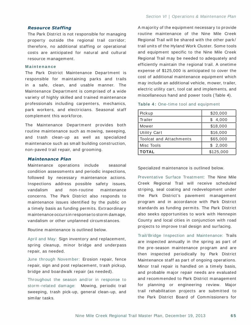
65Nine Mile Creek Regional Trail Master Plan, December 19, 2013
Section VI | Operations & Maintenance Plan
Resource StaffingThe Park District is not responsible for managing property outside the regional trail corridor; therefore, no additional staffing or operational costs are anticipated for natural and cultural resource management.
MaintenanceThe Park District Maintenance Department is responsible for maintaining parks and trails in a safe, clean, and usable manner. The Maintenance Department is comprised of a wide variety of highly skilled and trained maintenance professionals including carpenters, mechanics, park workers, and electricians. Seasonal staff complement this workforce.
The Maintenance Department provides both routine maintenance such as mowing, sweeping, and trash clean-up as well as specialized maintenance such as small building construction, non-paved trail repair, and grooming.
Maintenance PlanMaintenance operations include seasonal condition assessments and periodic inspections, followed by necessary maintenance actions. Inspections address possible safety issues, vandalism and non-routine maintenance concerns. The Park District also responds to maintenance issues identified by the public on a timely basis as funding permits. Extraordinary maintenance occurs in response to storm damage, vandalism or other unplanned circumstances.
Routine maintenance is outlined below.
April and May: Sign inventory and replacement, spring cleanup, minor bridge and underpass repair, as needed.
June through November: Erosion repair, fence repair, sign and post replacement, trash pickup, bridge and boardwalk repair (as needed).
Throughout the season and/or in response to storm-related damage: Mowing, periodic trail sweeping, trash pick-up, general clean-up, and similar tasks.
A majority of the equipment necessary to provide routine maintenance of the Nine Mile Creek Regional Trail will be shared with the other park/trail units of the Hyland Work Cluster. Some tools and equipment specific to the Nine Mile Creek Regional Trail may be needed to adequately and efficiently maintain the regional trail. A onetime expense of $125,000 is anticipated to cover the cost of additional maintenance equipment which may include an additional vehicle, mower, trailer, electric utility cart, tool cat and implements, and miscellaneous hand and power tools (Table 4).
Specialized maintenance is outlined below.
Preventative Surface Treatment: The Nine Mile Creek Regional Trail will receive scheduled striping, seal coating and redevelopment under the Park District’s pavement management program and in accordance with Park District standards as funding permits. The Park District also seeks opportunities to work with Hennepin County and local cities in conjunction with road projects to improve trail design and surfacing.
Trail/Bridge Inspection and Maintenance: Trails are inspected annually in the spring as part of the pre-season maintenance program and are then inspected periodically by Park District Maintenance staff as part of ongoing operations. Minor trail repair is handled on a timely basis, and probable major repair needs are evaluated and recommended to Park District management for planning or engineering review. Major trail rehabilitation projects are submitted to the Park District Board of Commissioners for
Table 4: One-time tool and equipment
Pickup $20,000Trailer $ 4,000Mower $18,000Utility Cart $16,000Toolcat and Attachments $65,000Misc Tools $ 2,000TOTAL $125,000
Three Rivers Park District66
Section VI | Operations & Maintenance Plan
funding as part of the annual operating budget, preservation and rehabilitation program, or capital improvement program.
The ownership and maintenance responsibilities associated with new grade-separated pedestrian bridges constructed as part of the Nine Mile Creek Regional Trail will be determined when the bridges move into the design development phase.
Bridges owned by MnDOT are the responsibility of MnDOT. The Park District only maintains the trail use of said bridges and underpasses. Maintenance includes sweeping, cleaning and painting as necessary.
Noxious Weed Management: The Park District mechanically or chemically removes noxious weeds within the defined trail corridor at the request of cities.
Edge/Trail Shoulder Vegetation Management: The Park District maintains vegetative clearances so as not to negatively affect trail use on any sections where trail shoulder vegetation exists.
Maintenance StaffingThe Nine Mile Creek Regional Trail primarily will be maintained by the Hyland Work Cluster, which currently provides maintenance services to one park reserve, one regional park, one special recreation feature, and other regional trail segments. The inclusion of the Nine Mile Creek Regional Trail and the planned Intercity Regional Trail will add approximately 15 miles of regional trail maintenance responsibilities to the Hyland Work Cluster. The Hyland Work Cluster is also anticipated to assume additional maintenance responsibilities for a new cross-country ski trail with snowmaking facility and downhill ski chalet at Hyland Lake Park Reserve.
Existing vacancies will be redirected to provide the expected trail maintenance needs.
Maintenance for the trail segments within Hopkins, Minnetonka, Edina, and Richfield is the Park District’s responsibility.
The estimated routine Nine Mile Creek Regional Trail maintenance costs including staffing for the trail segments through Hopkins, Minnetonka, Edina, and Richfield (12.3 miles excluding shared segment of Intercity Regional Trail in Richfield), is $29,000/year in 2013. Additional costs for trail surface preservation and rehabilitation (trail surface repairs, striping requirements, and pavement requirements) are an additional $36,000/year, assuming a 30-year pavement life. The combined annual maintenance operation estimated cost for both routine and trail surface preventative maintenance is $65,000/year. This equates to an estimated $.15/trail visit. Routine maintenance costs will primarily be funded through the Park District operational budget. Surface preventative maintenance will primarily be funded through the Park District Asset Management Program.
In the event that the development of rain gardens, best management practices, or other mitigation requirements require ongoing maintenance, additional seasonal staffing may be required to complete the work. If necessary, seasonal staffing budgets will be developed and evaluated during the design development phase.
General Operations ConsiderationsSustainabilityThe Park District’s 2012 Sustainability Plan guides the Park District’s efforts toward achieving established sustainability goals and targets by outlining broad strategies for organizational implementation.
The following goals provide broad guidance and intent to Park District sustainability efforts:
• Manage and operate District parklands and facilities in a manner that ensures ecologic, financial and social integrity of the park system in perpetuity.
• Reduce dependence on fossil fuels to minimize green house gas (GHG) emissions and reduce public expenditures.
67Nine Mile Creek Regional Trail Master Plan, December 19, 2013
Section VI | Operations & Maintenance Plan
• Reduce the amount of waste sent to the incinerator and landfill to minimize costs and GHG emissions.
• Preserve groundwater supplies in the Twin Cities metropolitan area to ensure that current and future water needs can be met.
• Reduce Park District environmental impacts to demonstrate (or model) organizational commitment to environmental stewardship.
• Provide opportunities for public education and involvement in Park District sustainability initiatives.
• Design parks and trails that maximize the ability of the public to use non-motorized transportation.
To move towards sustainability targets for GHG emissions, waste, and groundwater consumption reduction for the years 2015, 2025, and 2050, the Park District will focus on the following areas of implementation: facility systems, vehicles/equipment and fuel use, waste management, groundwater conservation, sustainable work practices, public education and advocacy and system planning and development.
The Park District strives to utilize appropriate sustainable best management practices and guidelines such as the Minnesota Sustainable Building Guidelines (B3 Project) and Leadership in Energy and Environmental Development (LEED) Rating System on construction projects.
Public AwarenessThe Park District’s Communications Department manages a centralized communications function that oversees public relations, marketing, media relations, the website, brand management, event planning and promotion. A number of effective marketing and outreach tools are used to promote the Park District, including a district-wide map, website, direct mail, press releases, centralized reservation system, feedback phone line, brochures, ads and on-site promotion.
The Park District collaborates with a wide array of community, business and government organizations to promote its facilities, programs and services, and to educate the public about its resources. The Park District also works with the Metropolitan Council and the State Office of Tourism to leverage shared opportunities for creating awareness and visibility and works with county agencies to provide information about scholarship programs available to individuals receiving economic assistance.
Bloomington Operation PlanAs a regional parks implementing agency, Bloomington will be responsible to provide existing levels of public safety, natural and cultural resources, and maintenance for the segment of the regional trail will within Bloomington.
Public SafetyBloomington Police Officers will provide public safety services and will monitor the trail as part of routine patrol through the area. Since Bloomington already provides this level of service along the planned regional trail corridor, no significant increase in public safety staffing or operations costs are anticipated.
Natural & Cultural ResourcesThe trail is planned in a completely developed area of Bloomington and improvements are proposed to occur as part of future redevelopment efforts. As such, no natural or cultural resources services, staffing, or operational costs are foreseen.
MaintenanceBloomington maintenance operations will be limited to seasonal condition assessments and periodic inspections, followed by necessary maintenance actions. Inspections will address possible safety issues, vandalism, and non-routine maintenance concerns. Bloomington will also respond to maintenance issues identified by the public, on a timely basis, as funding permits. Extraordinary maintenance occurs in response to storm damage, vandalism and other unplanned circumstances.
Three Rivers Park District68
Section VI | Operations & Maintenance Plan
The trail will receive scheduled striping, seal costing, and reconstruction under Bloomington’s Sidewalk and Trail Pavement Management Plan (PMP) in accordance with Bloomington standards as funding permits.
• Sign inventory and replacement, spring cleanup, trash pickup, erosion repair, fence repair, bituminous patching, and striping replacement will occur as needed.
• Mowing adjacent to trails will be maintained by Bloomington for segments adjacent to Bloomington property and by adjacent property owners for segments adjacent to private property.
Bloomington will provide snow removal maintenance with the goal of removal occurring within 48 hours of an event as resources allow. It is anticipated that snow removal will occur using a truck with a mounted plow.
Since Bloomington already maintains the existing sidewalk/trail infrastructure, additional maintenance costs are limited to preventative maintenance treatments (fog sealing) following the replacement of concrete sidewalks with a bituminous trail. The anticipated cost for fog sealing is $6,000/mile every 5 years. This equates to $2,688/year for 2.24 miles (excluding shared segment of Intercity Regional Trail).
69Nine Mile Creek Regional Trail Master Plan, December 19, 2013
Section VII
Estimated Costs & Funding SourcesRegional trail implementation has both initial costs (acquisition and development) and on-going costs (operations and maintenance). Trail development will occur as opportunities to coordinate with other agencies/projects occur, funding becomes available, and at the discretion of the Park District Board of Commissioners and Bloomington City Council.
The Park District and City of Bloomington are both regional park implementing agencies. Consequently, the Park District would assume all acquisition, construction, and operation responsibilities for the segments within Hopkins, Minnetonka, Edina, Richfield, and the MAC Alternative. The Park District and Bloomington will work corroboratively to acquire, construct, and operate the Bloomington segment.
Acquisition and DevelopmentAcquisition CostsThe completion of missing segments of the Nine Mile Creek Regional Trail and the reconstruction of existing segments that do not meet preferred regional trail standards will require the acquisition of trail easements.
The estimated easement and/or right-of-way acquisition cost is $1.9 million for the Nine Mile Creek Regional Trail.
See Appendix D, Detailed Cost Estimate for further information.
Development Costs Regional trail development includes the cost to prepare the site; reconfigure roadways as required; modify drainage patterns where necessary; pave the trail; construct bridges and
boardwalks, and install signage, striping, and landscaping. In total, the estimated development cost for the Nine Mile Creek Regional Trail is ~$23.5 million.
See Appendix D, Detailed Cost Estimate for further information.
Acquisition and Development FundingAcquisition and development funding will likely come from a variety of sources. A summary of potential funding sources follows.
• Federal Transportation Grants (MAP21) • Metropolitan Council/State of Minnesota
(Regional Parks Capital Improvement Program (CIP), Environment and Natural Resource Trust Fund Acquisition Account, and Parks and Trails Legacy Fund Acquisition Account)
• Federal Recreation Trail Grant Program• Park District General Obligation Bonds
Three Rivers Park District70
Section VII | Estimated Costs & Funding
• Bloomington General Obligation Bonds• Donations• Hennepin County Bikeway Grant Program
For a more detailed implementation and funding plan, see Section IV: Design and Implementation.
OperationThe estimates for future operating budget expenditures, as reflected in the master plan, represent anticipated additional costs incurred by the Park District and Bloomington as capital development is implemented.
Public Safety CostsDue to cost savings associated with providing trail-related public safety through a district-wide program and the opportunity to coordinate patrol with the existing Cedar Lake, Minnesota River Bluffs, Lake Minnetonka, North Cedar Lake, and Intercity Regional Trails, no additional Park District funds are needed to assume patrol of its portion of the Nine Mile Creek Regional Trail.
Bloomington is already patrolling the Nine Mile Creek Regional Trail corridor; therefore, no additional public safety costs are foreseen for its portion of the regional trail.
Natural Resources CostsDue to the limited Nine Mile Creek Regional Trail corridor width of 16-20 feet, no additional costs for natural resources management are anticipated from either agency.
Maintenance CostsPortions of the Nine Mile Creek Regional Trail within Hopkins, Minnetonka, Edina, and Richfield property are the Park District’s responsibility to maintain, and the portions within Bloomington are Bloomington’s responsibility to maintain.
The Park District estimates a onetime expense of $125,000 for maintenance equipment and tools for its portion of the regional trail. Bloomington does not anticipate any additional equipment or tool needs for its portion.
At the time the trail is fully implemented, the Park District’s maintenance costs are estimated to increase by $65,000/annually.
Bloomington anticipates an increase in annual preventative surface treatment maintenance costs for its portion of the regional trail in the amount of $2,688.
Operation FundingOperation costs for the Park District’s regional trail portion will be primarily funded through the Park District Operating Budget. The Operating Budget’s primary source of funds is property taxes with some revenue received from the State of Minnesota as part of the Operations and Maintenance Fund allocations from the Metropolitan Council. Additional costs associated with surface preventative maintenance will be funded from the Park District’s Asset Management Program, which includes revenues allocated to the Park District from the State of Minnesota as well as Park District general obligation bonds. All operation and maintenance costs are subject to the annual operating budget preparation process approved by the Park District Board of Commissioners.
Operation and maintenance costs for the Bloomington portion of the regional trail will be primarily funded through the Bloomington Public Works Budget and Police Budget. All operating, maintenance, and public safety costs are subject to the annual operating budget preparation process approved by the Bloomington City Council.
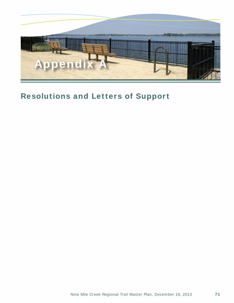
71Nine Mile Creek Regional Trail Master Plan, December 19, 2013
Appendix A
Resolutions and Letters of Support
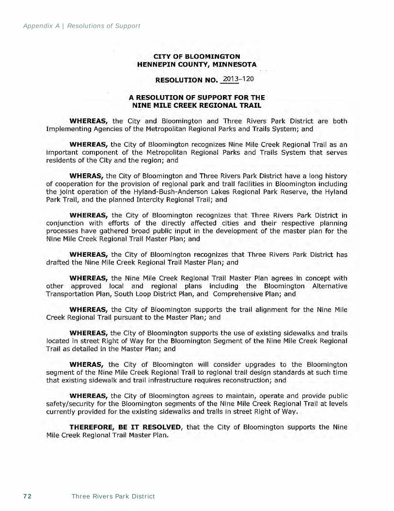
Three Rivers Park District72
Appendix A | Resolutions of Support
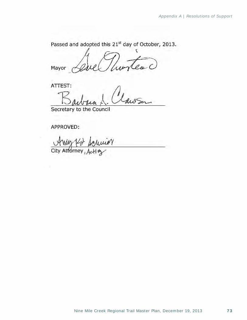
73Nine Mile Creek Regional Trail Master Plan, December 19, 2013
Appendix A | Resolutions of Support
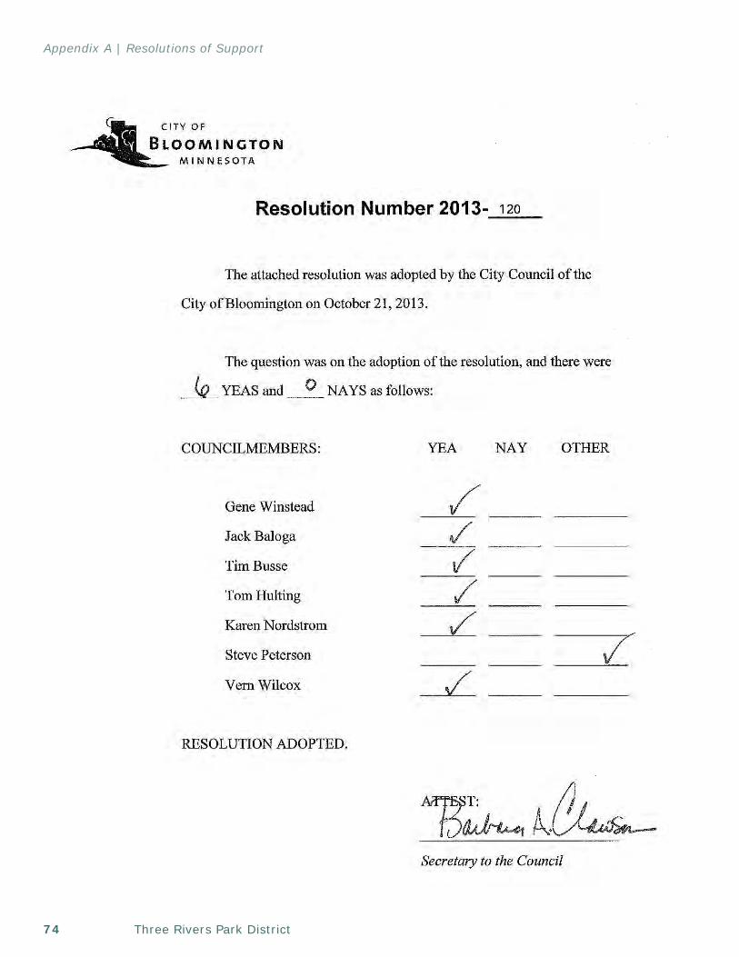
Three Rivers Park District74
Appendix A | Resolutions of Support
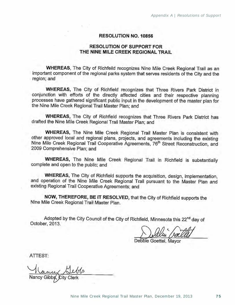
75Nine Mile Creek Regional Trail Master Plan, December 19, 2013
Appendix A | Resolutions of Support

Three Rivers Park District76
Appendix A | Resolutions of Support
This page left intentionally blank
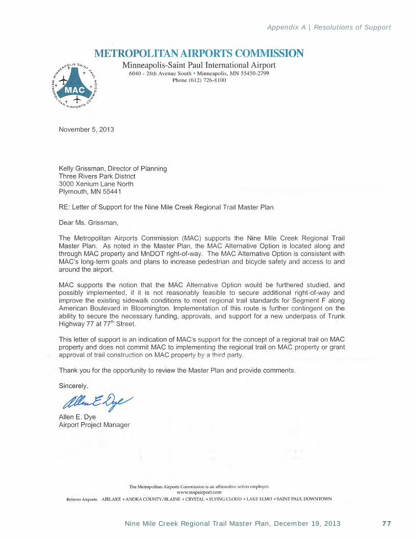
77Nine Mile Creek Regional Trail Master Plan, December 19, 2013
Appendix A | Resolutions of Support

Three Rivers Park District78
Appendix A | Resolutions of Support
This page left intentionally blank
79Nine Mile Creek Regional Trail Master Plan, December 19, 2013
Appendix B
Nine Mile Creek Trail Status and Implementation Plan
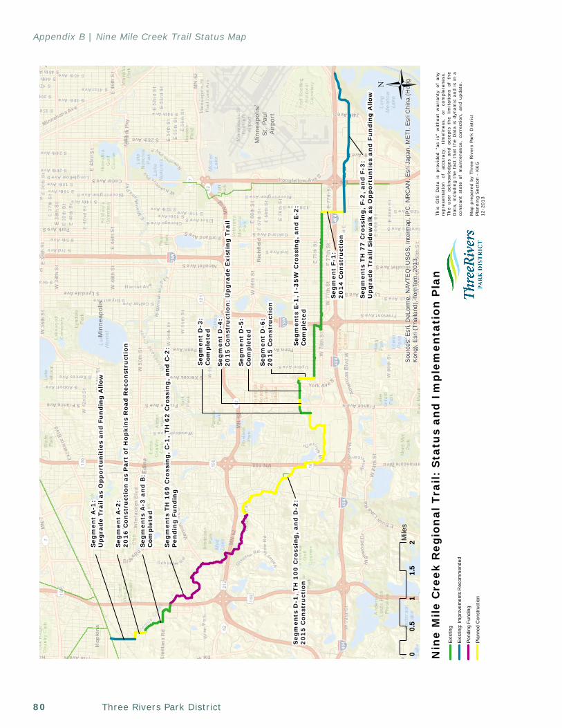
Three Rivers Park District80
Appendix B | Nine Mile Creek Trail Status Map
Blo
omin
gton
Min
neap
olis
/St
. Pa
ulAi
rpor
t
Min
neap
olis
Sou
rces
: Esr
i, D
eLor
me,
NAV
TEQ
, US
GS
, Int
erm
ap, i
PC
, NR
CA
N, E
sri J
apan
, ME
TI, E
sri C
hina
(Hon
gK
ong)
, Esr
i (Th
aila
nd),
Tom
Tom
, 201
3
Nin
e M
ile
Cre
ek R
egio
nal
Tra
il:
Sta
tus
and
Im
ple
men
tati
on
Pla
n
00.
51
1.5
2Mile
sÜ
This
GIS
Dat
a is
pro
vide
d "a
s is
" w
itho
ut w
arra
nty
of a
nyre
pres
enta
tion
of
ac
cura
cy,
tim
elin
ess,
or
co
mpl
eten
ess.
The
user
ack
now
ledg
es a
nd a
ccep
ts t
he l
imit
atio
ns o
f th
eD
ata,
inc
ludi
ng t
he f
act
that
the
Dat
a is
dyn
amic
and
is
in a
cons
tant
sta
te o
f m
aint
enan
ce,
corr
ectio
n, a
nd u
pdat
e.
Map
pre
pare
d by
Thr
ee R
iver
s Pa
rk D
istr
ict
Plan
ning
Sec
tion
- K
KG
12-2
013
Seg
men
t A
-1:
Up
gra
de
Tra
il a
s O
pp
ort
un
itie
s an
d F
un
din
g A
llo
w
Seg
men
ts T
H 7
7 C
ross
ing
, F-
2,
an
d F
-3:
Up
gra
de
Tra
il/
Sid
ewa
lk a
s O
pp
ort
un
ties
an
d F
un
din
g A
llow
Seg
men
ts E
-1,
I-3
5W
Cro
ssin
g,
and
E-2
:C
omp
lete
d
Seg
men
ts A
-3 a
nd
B:
Com
ple
ted
Seg
men
ts T
H 1
69
Cro
ssin
g,
C-1
, T
H 6
2 C
ross
ing
, an
d C
-2:
Pen
din
g F
un
din
g
Seg
men
ts D
-1,
TH
10
0 C
ross
ing
, an
d D
-2:
20
15
Co
nst
ruct
ion
Seg
men
t D
-6:
20
15
Co
nst
ruct
ion
Seg
men
t D
-3:
Com
ple
ted
Seg
men
t D
-5:
Com
ple
ted
Seg
men
t F-
1:
20
14
Co
nst
ruct
ion
Exis
ting
Exis
ting:
Impr
ovem
ents
Rec
omm
ende
d
Pend
ing
Fund
ing
Plan
ned
Con
stru
ctio
n
Seg
men
t A
-2:
20
16
Co
nst
ruct
ion
as
Par
t o
f H
op
kin
s R
oad
Rec
on
stru
ctio
n
Seg
men
t D
-4:
20
15
Co
nst
ruct
ion
: U
pg
rad
e E
xist
ing
Tra
il
81Nine Mile Creek Regional Trail Master Plan, December 19, 2013
Appendix C
MLCCS Map
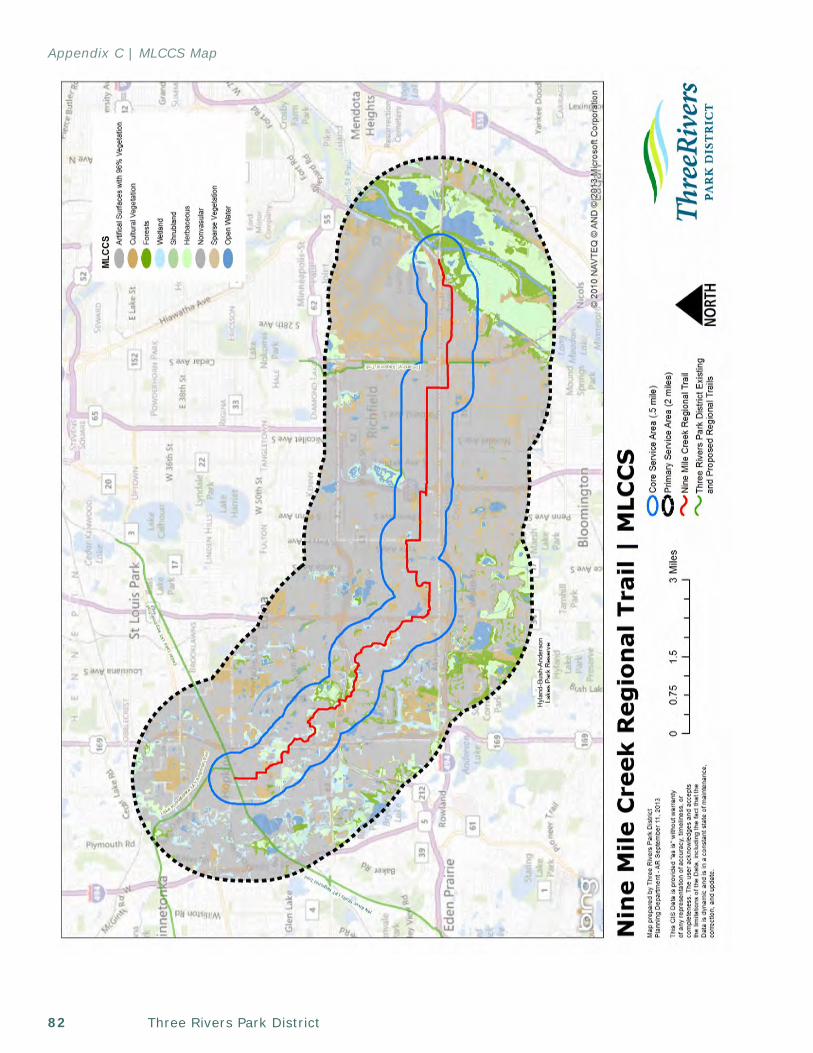
Three Rivers Park District82
Appendix C | MLCCS Map
83Nine Mile Creek Regional Trail Master Plan, December 19, 2013
Appendix D
Cost Estimate
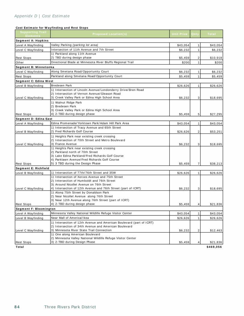
Three Rivers Park District84
Appenidx D | Cost Estimate
Cost Estimate for Wayfinding and Rest Stops Supporting Trail
Elements Proposed Location(s) Unit Price Qnty Total
Segment A: HopkinsLevel A Wayfinding Valley Parking (parking lot area) $43,054 1 $43,054Level C Wayfinding Intersection of 11th Avenue and 7th Street $6,232 1 $6,232
Rest Stops1) Parkland along 11th Avenue2) TBD during design phase $5,459 2 $10,918
Other Directional Blade at Minnesota River Bluffs Regional Trail $200 1 $200Segment B: MinnetonkaLevel C Wayfinding Along Smetana Road/Opportunity Court $6,232 1 $6,232Rest Stops Parkland along Smetana Road/Opportunity Court $5,459 1 $5,459Segment C: Edina WestLevel B Wayfinding Bredesen Park $26,626 1 $26,626
Level C Wayfinding
1) Intersection of Lincoln Avenue/Londonderry Drive/Bren Road2) Intersection of Vernon Avenue/Gleason Road3) Creek Valley Park or Edina High School Area $6,232 3 $18,695
Rest Stops
1) Walnut Ridge Park2) Bredesen Park3) Creek Valley Park or Edina High School Area4) 2-TBD during design phase $5,459 5 $27,295
Segment D: Edina EastLevel A Wayfinding Edina Promenade/Yorktown Park/Adam Hill Park Area $43,054 1 $43,054
Level B Wayfinding1) Intersection of Tracy Avenue and 65th Street2) Fred Richards Golf Course $26,626 2 $53,251
Level C Wayfinding
1) Heights Park near existing creek crossing2) Intersection of 70th Street and Metro Boulevard3) France Avenue $6,232 3 $18,695
Rest Stops
1) Heights Park near existing creek crossing2) Parkland north of 70th Street3) Lake Edina Parkland/Fred Richards Golf Course4) Parklawn Avenue/Fred Richards Golf Course5) 3 TBD during the Design Phase $5,459 7 $38,213
Segment E: RichfieldLevel B Wayfinding 1) Intersection of 77th/76th Street and 35W $26,626 1 $26,626
Level C Wayfinding
1) Intersection of Xerxes Avenue and 75th Street2) Intersection of Humboldt and 76th Street3) Around Nicollet Avenue on 76th Street4) Intersection of 12th Avenue and 76th Street (part of ICRT) $6,232 3 $18,695
Rest Stops
1) Along 75th Street by Donaldson Park2) Near Nicollet Avenue along 76th Street 3) Near 12th Avenue along 76th Street (part of ICRT)4) 2-TBD during design phase $5,459 4 $21,836
Segment F: BloomingtonLevel A Wayfinding Minnesota Valley National Wildlife Refuge Visitor Center $43,054 1 $43,054Level B Wayfinding Near Mall of America/Ikea $26,626 1 $26,626
Level C Wayfinding
1) Intersection of 12th Avenue and American Boulevard (part of ICRT)2) Intersection of 34th Avenue and American Boulevard3) Minnesota River State Trail Connection $6,232 2 $12,463
Rest Stops
1) One along American Boulevard2) Minnesota Valley National Wildlife Refuge Visitor Center3) 2-TBD during Design Phase $5,459 4 $21,836
Total $469,056
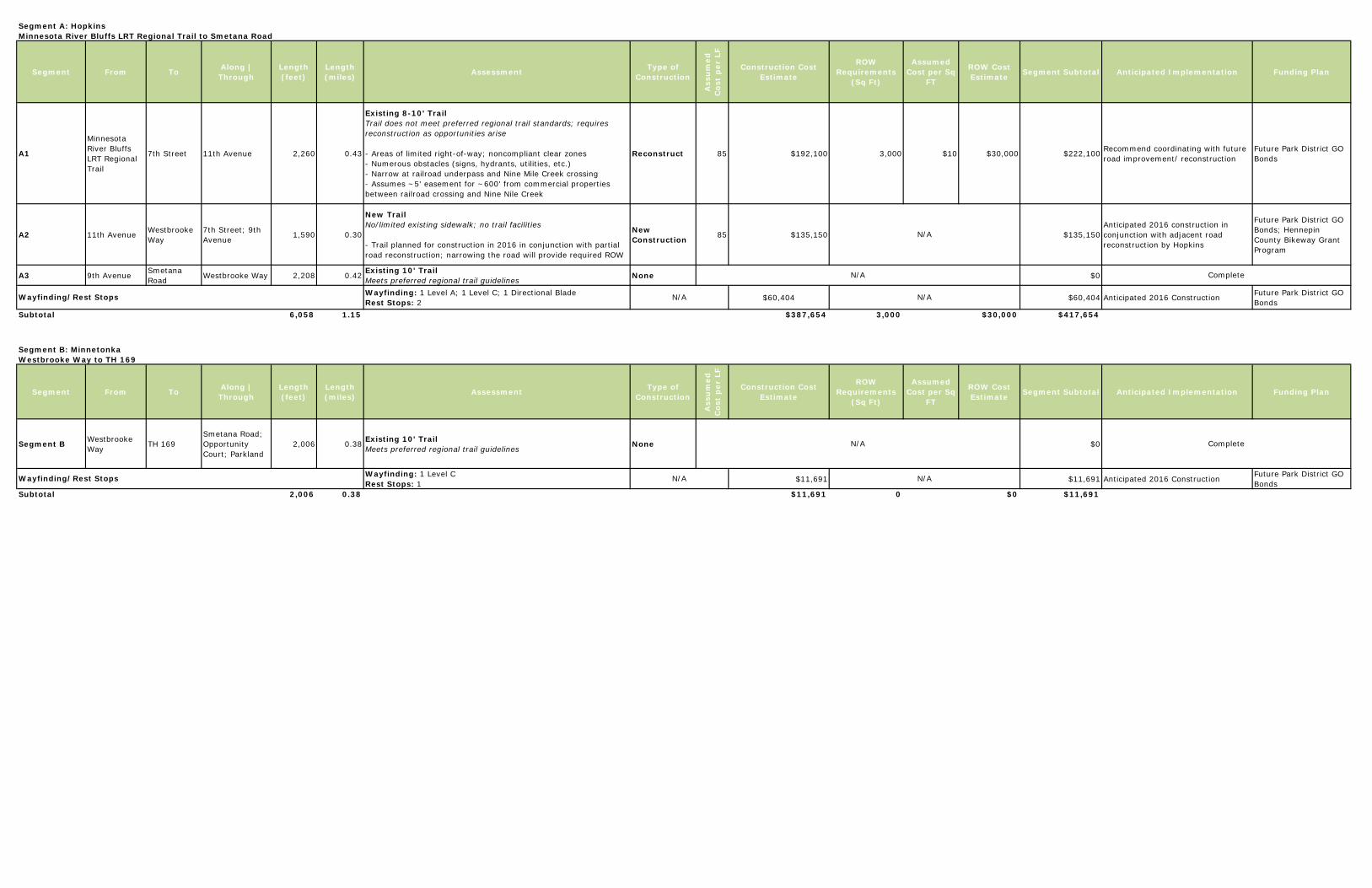
Segment A: HopkinsMinnesota River Bluffs LRT Regional Trail to Smetana Road
Segment From To Along | Through
Length (feet)
Length (miles) Assessment Type of
Construction
Ass
um
ed
Cos
t p
er L
F
Construction Cost Estimate
ROW Requirements
(Sq Ft)
Assumed Cost per Sq
FT
ROW Cost Estimate Segment Subtotal Anticipated Implementation Funding Plan
A1
Minnesota River Bluffs LRT Regional Trail
7th Street 11th Avenue 2,260 0.43
Existing 8-10' TrailTrail does not meet preferred regional trail standards; requires reconstruction as opportunities arise
- Areas of limited right-of-way; noncompliant clear zones- Numerous obstacles (signs, hydrants, utilities, etc.)- Narrow at railroad underpass and Nine Mile Creek crossing- Assumes ~5' easement for ~600' from commercial properties between railroad crossing and Nine Nile Creek
Reconstruct 85 $192,100 3,000 $10 $30,000 $222,100 Recommend coordinating with future road improvement/ reconstruction
Future Park District GO Bonds
A2 11th Avenue Westbrooke Way
7th Street; 9th Avenue 1,590 0.30
New TrailNo/limited existing sidewalk; no trail facilities
- Trail planned for construction in 2016 in conjunction with partial road reconstruction; narrowing the road will provide required ROW
New Construction 85 $135,150 $135,150
Anticipated 2016 construction in conjunction with adjacent road reconstruction by Hopkins
Future Park District GO Bonds; Hennepin County Bikeway Grant Program
A3 9th Avenue Smetana Road Westbrooke Way 2,208 0.42 Existing 10' Trail
Meets preferred regional trail guidelines None $0
Wayfinding: 1 Level A; 1 Level C; 1 Directional Blade Rest Stops: 2 $60,404 $60,404 Anticipated 2016 Construction Future Park District GO
BondsSubtotal 6,058 1.15 $387,654 3,000 $30,000 $417,654
Segment B: MinnetonkaWestbrooke Way to TH 169
Segment From To Along | Through
Length (feet)
Length (miles) Assessment Type of
Construction
Ass
um
ed
Cos
t p
er L
F
Construction Cost Estimate
ROW Requirements
(Sq Ft)
Assumed Cost per Sq
FT
ROW Cost Estimate Segment Subtotal Anticipated Implementation Funding Plan
Segment B Westbrooke Way TH 169
Smetana Road; Opportunity Court; Parkland
2,006 0.38 Existing 10' TrailMeets preferred regional trail guidelines None $0
Wayfinding: 1 Level C Rest Stops: 1 $11,691 $11,691 Anticipated 2016 Construction Future Park District GO
BondsSubtotal 2,006 0.38 $11,691 0 $0 $11,691
Complete
Complete
Wayfinding/Rest Stops
Wayfinding/Rest Stops
N/A
N/A
N/A
N/A
N/A
N/A
N/A
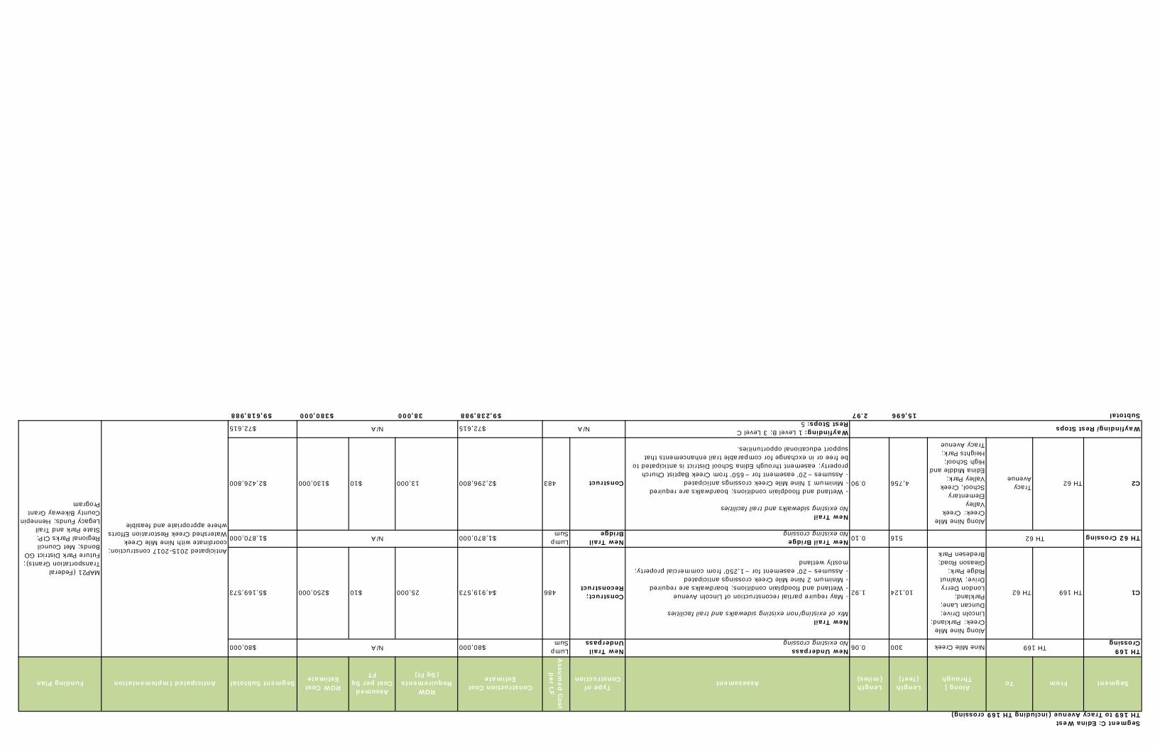
Segment C: Edina WestTH 169 to Tracy Avenue (including TH 169 crossing)
SegmentFromToAlong | Through
Length (feet)
Length (miles)AssessmentType of
Construction
Assu
med
Cost
per LF
Construction Cost Estimate
ROW Requirements
(Sq Ft)
Assumed Cost per Sq
FT
ROW Cost EstimateSegment Subtotal Anticipated ImplementationFunding Plan
TH 169 CrossingNine Mile Creek3000.06New Underpass
No existing crossingNew Trail Underpass
Lump Sum $80,000$80,000
C1TH 169TH 62
Along Nine Mile Creek: Parkland; Lincoln Drive; Duncan Lane; Parkland; London Derry Drive; Walnut Ridge Park; Gleason Road; Bredesen Park
10,1241.92
New Trail Mix of existing/non existing sidewalks and trail facilities
- May require partial reconstruction of Lincoln Avenue - Wetland and floodplain conditions; boardwalks are required- Minimum 2 Nine Mile Creek crossings anticipated- Assumes ~20' easement for ~1,250' from commercial property; mostly wetland
Construct; Reconstruct486$4,919,57325,000$10$250,000$5,169,573
TH 62 Crossing5160.10New Trail Bridge No existing crossing
New Trail Bridge
Lump Sum $1,870,000$1,870,000
C2TH 62Tracy Avenue
Along Nine Mile Creek: Creek Valley Elementary School, Creek Valley Park; Edina Middle and High School; Heights Park; Tracy Avenue
4,7560.90
New Trail No existing sidewalks and trail facilities
- Wetland and floodplain conditions; boardwalks are required- Minimum 1 Nine Mile Creek crossings anticipated - Assumes ~20' easement for ~650' from Creek Baptist Church property; easement through Edina School District is anticipated to be free or in exchange for comparable trail enhancements that support educational opportunities.
Construct483$2,296,80013,000$10$130,000$2,426,800
Wayfinding: 1 Level B; 3 Level C Rest Stops: 5$72,615$72,615
Subtotal15,6962.97$9,238,98838,000$380,000$9,618,988
N/A Wayfinding/Rest StopsN/A
TH 169N/A
TH 62N/A
Anticipated 2015-2017 construction; coordinate with Nine Mile Creek Watershed Creek Restoration Efforts where appropriate and feasible
MAP21 (Federal Transportation Grants); Future Park District GO Bonds; Met Council Regional Parks CIP; State Park and Trail Legacy Funds; Hennepin County Bikeway Grant Program
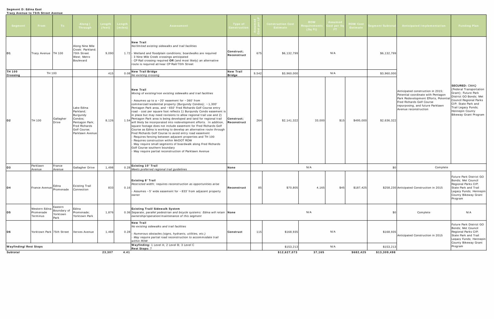
Segment D: Edina EastTracy Avenue to 75th Street Avenue
Segment From To Along | Through
Length (feet)
Length (miles) Assessment Type of
Construction
Ass
um
ed
Cos
t p
er L
F
Construction Cost Estimate
ROW Requirements
(Sq Ft)
Assumed Cost per Sq
FT
ROW Cost Estimate Segment Subtotal Anticipated Implementation Funding Plan
D1 Tracy Avenue TH 100
Along Nine Mile Creek: Parkland; 70th Street West; Metro Boulevard
9,090 1.72
New Trail No/limited existing sidewalks and trail facilities
- Wetland and floodplain conditions; boardwalks are required- 3 Nine Mile Creek crossings anticipated - CP Rail crossing required OR (and most likely) an alternative route is required at/near CP Rail/70th Street
Construct; Reconstruct 675 $6,132,799 $6,132,799
TH 100 Crossing 415 0.08 New Trail Bridge
No existing crossingNew Trail Bridge 9,542 $3,960,000 $3,960,000
D2 TH 100 Gallagher Drive
Lake Edina Parkland; Burgundy Condos; Pentagon Park; Fred Richards Golf Course; Parklawn Avenue
8,126 1.54
New Trail Mixing of existing/non existing sidewalks and trail facilities
- Assumes up to a ~20' easement for ~360' from commercial/residential property (Burgundy Condos); ~1,300' Pentagon Park area, and ~650' Fred Richards Golf Course entry road - cost per square foot reflects 1) Burgundy Condo easement is in place but may need revisions to allow regional trail use and 2) Pentagon Park area is being developed and land for regional trail will likely be incorporated into redevelopment efforts. In addition, square footage does not include easement for Fred Richards Golf Course as Edina is working to develop an alternative route through Fred Richards Golf Course to avoid entry road easement- Requires fencing between adjacent properties and TH 100- Requires construction within MnDOT ROW- May require small segments of boardwalk along Fred Richards Golf Course southern boundary- May require partial reconstruction of Parklawn Avenue
Construct; Reconstruct 264 $2,141,322 33,000 $15 $495,000 $2,636,322
D3 Parklawn Avenue
France Avenue Gallagher Drive 1,498 0.28 Existing 10' Trail
Meets preferred regional trail guidelines None $0
D4 France Avenue Edina Promenade
Existing Trail Connection 833 0.16
Existing 8' TrailRestricted width; requires reconstruction as opportunities arise
- Assumes ~5' wide easement for ~833' from adjacent property owner
Reconstruct 85 $70,805 4,165 $45 $187,425 $258,230 Anticipated Construction in 2015
Future Park District GO Bonds; Met Council Regional Parks CIP; State Park and Trail Legacy Funds; Hennepin County Bikeway Grant Program
D5Western Edina Promenade Terminus
Eastern Boundary of Yorktown Park
Edina Promenade; Yorktown Park
1,876 0.36Existing Trail/Sidewalk SystemSeparate, parallel pedestrian and bicycle systems: Edina will retain ownership/operation/maintenance of this segment
None $0 Complete N/A
D6 Yorktown Park 75th Street Xerxes Avenue 1,469 0.28
New Trail No existing sidewalks and trail facilities
- Numerous obstacles (signs, hydrants, utilities, etc.)- May require partial road reconstruction to accommodate trail within ROW
Construct 115 $168,935 $168,935
Wayfinding: 1 Level A; 2 Level B; 3 Level C Rest Stops: 7 $153,213 $153,213
Subtotal 23,307 4.41 $12,627,073 37,165 $682,425 $13,309,498
Wayfinding/Rest Stops
N/A
N/A
N/A
N/A
N/A
TH 100 N/A
Anticipated Construction in 2015
Future Park District GO Bonds; Met Council Regional Parks CIP; State Park and Trail Legacy Funds; Hennepin County Bikeway Grant Program
Anticipated construction in 2015; Potential coordinate with Pentagon Park Redevelopment Efforts, Potential Fred Richards Golf Course repurposing, and future Parklawn Avenue reconstruction
SECURED: CMAQ (Federal Transportation Grant); Future Park District GO Bonds; Met Council Regional Parks CIP; State Park and Trail Legacy Funds; Hennepin County Bikeway Grant Program
Complete
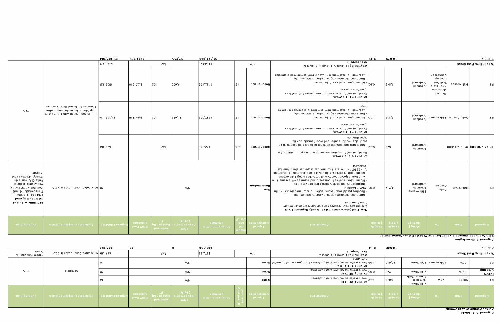
Segment E: RichfieldXerxes Avenue to 12th Avenue
SegmentFromToAlong | Through
Length (feet)
Length (miles)AssessmentType of
Construction
Assu
med
C
ost per LF
Construction Cost Estimate
ROW Requirements
(Sq Ft)
Assumed Cost per Sq
FT
ROW Cost EstimateSegment Subtotal Anticipated ImplementationFunding Plan
E1XerxesI-35W75th Street; Humboldt Avenue; 76th
5,8181.10Existing 10' TrailMeets preferred regional trail guidelines None$0
I-35W Crossing76th Street2460.05Existing 10' Trail
Meets preferred regional trail guidelines None$0
E2I-35W 12th Avenue76th Street10,4981.99Existing 8'-8.5' TrailMeets preferred regional trail guidelines in conjunction with parallel bike lanes
None$0
Wayfinding: 1 Level B; 3 Level C Rest Stops: 4 $67,156$67,156Anticipated Construction in 2014Future Park District
BondsSubtotal16,5623.14$67,1560$0$67,156
Segment F: Bloomington 12th Avenue to Minnesota Valley National Wildlife Refuge Visitor Center
SegmentFromToAlong | Through
Length (feet)
Length (miles)AssessmentType of
Construction
Assumed
Cost per LF
Construction Cost Estimate
ROW Requirements
(Sq Ft)
Assumed Cost per Sq
FT
ROW Cost EstimateSegment Subtotal Anticipated ImplementationFunding Plan
F1 76th Street Cedar Avenue
12th Avenue; American Boulevard
4,2770.81
New Trail (share route with Intercity Regional Trail)Existing sidewalk, requires removal and reconstruction with bituminous trail
- Numerous obstacles (signs, hydrants, utilities, etc.) - Requires partial road reconstruction to accommodate trail within ROW in Richfield- Includes new pedestrian/bicycle bridge over I-494- Bloomington requires 5' boulevard and assumes ~5' easement for ~450' from adjacent commercial properties along 12th Avenue- Bloomington requires a 6' boulevard and assumes ~5' easement for ~1840' from adjacent commercial properties along American Boulevard
New Construction$0Anticipated Construction in 2015
SECURED as Part of Intercity Regional Trail: STP (Federal Transportation Grant); Park District GO Bonds; Met Council Regional Parks CIP; Hennepin County Bikeway Grant Program
TH 77 CrossingAmerican Boulevard6300.12
Existing 6-8' SidewalkRestricted width; requires reconstruction as opportunities arise
- Underpass configuration does not allow for trail expansion on south side; would require road reconfiguration/partial reconstruction
Reconstruct115$72,450$72,450
F2Cedar Avenue 34th AvenueAmerican Boulevard6,3271.20
Existing ~8' SidewalkRestricted width; reconstruct to meet desired 10' width as opportunities arise
- Bloomington requires a 6' boulevard- Numerous obstacles (signs, hydrants, utilities, etc.)- Assumes ~5' easement from commercial properties for entire length
Reconstruct85$537,79531,635$21$664,335$1,202,130
F334th Avenue
Planned Minnesota River State Trail Fort Snelling Connection
American Boulevard4,8450.92
Existing ~8' SidewalkRestricted width; reconstruct to meet desired 10' width as opportunities arise
- Bloomington requires a 6' boulevard- Numerous obstacles (signs, hydrants, utilities, etc.)- Assumes ~5' easement for ~1,120' from commercial properties
Reconstruct85$411,8255,600$21$117,600$529,425
Wayfinding: 1 Level A, 1 Level B; 4 Level C Rest Stops: 4 $103,979$103,979
Subtotal16,0793.05$1,126,04937,235$781,935$1,907,984
N/A
N/A
N/A
Wayfinding/Rest Stops
Wayfinding/Rest Stops
N/A
I- 35WN/A
N/A
N/A
N/A
TH 77 CrossingN/A
TBD: In conjunction with future South Loop District Redevelopment and/or American Boulevard Reconstruction
TBD
CompleteN/A