Embed Size (px)
Citation preview

Maps & facts
www.oecd.org/swac | www.westafricagateway.org
We encourage the use of our maps! Please include the Club’s copyright, inform or contact us for specific requests: [email protected]
Phone +33 (0)1 45 24 89 87 Fax +33 (0)1 45 24 90 31 E-mail [email protected]
Postal address SWAC/OECD 2, rue André Pascal F–75775 Paris, Cedex 16
This map is without prejudice to the status of or sovereignty over any territory, to the delimitation of international frontiers and boundaries and to the name of any territory, city or area.
ClubSAHEL ANDWEST AFRICA
Secretariat
An Atlas of the Sahara-SahelGeography, Economics and Security
West African Studies
ClubSAHEL ANDWEST AFRICA
Secretariat
Extr
act
The country’s Human Development Index (HDI)
was the lowest in the world in 2014. Per capita GDP in 2013 was USD 778 (PPP), just over half that of Mali, and one-sixth that of Nigeria. The fertility rate was 7.6 children per woman of childbearing age in 2013, and the annual population growth rate was 3.9% (compared to 3% in Mali and Chad, and 1.9% in Algeria). 75% of the population live below the poverty line. The poverty rate is higher in rural areas where 82% of the population live. A fragile country, grappling with structural food and nutrition insecurity, Niger is caught in a tectonic of threats which are sharply increasing on its borders with Libya and Nigeria. Oil exploitation, which began in 2011, offers some hope in the economic sector.
Niger: iNterNal fragility aNd regioNal threats
n°19MArCH 2015
Sources: OECD (2014), “An Atlas of the Sahara-Sahel: Geography, Economics and Security”, West African Studies, OECD Publishing, Paris; AfDB, OECD, UNDP, UNECA (2014), African Economic Outlook.
LIBYA
NIGER
NIGERIA
CHAD
MALI
ALGERIA
Arlit
Kidal
BOKO HARAM
Agadez
Zinder
Agadem
DiffaMaradi
SokotoDosso
Niamey
KanoMaïduguri
N’Djamena
Abuja
Saharan zone: less than 200 mm of rainfall per year; approximately 600 000 km² and less than 0.5 millioninhabitants in its Nigerien part. Uranium mines and oil.
Ethnolinguistic groups
Sahel’s vulnerable zone: the inter-annual variation of the length of the rainy season exceeds 30%. Approximately 5 million rural inhabitants in its Nigerien part, predominantly agro-pastoralists.
Area regularly food and nutrition insecure
Area of conflict / instability
Regional diffusion of instability
Involuntary migration
TOUAREG
HAUSA
TU
BU
KANURI
Club DU SAHEL ET DEL'AFRIQUE DE L'OUEST
Secrétariat du
www.oecd.org/csao | www.portailouestafrique.org
Nous encourageons l’utilisation de nos cartes ! Veuillez nous informer et faire mention du
copyright du Club. Pour des demandes spécifiques, contacter : [email protected]
Tél +33 (0)1 45 24 89 87 Fax +33 (0)1 45 24 90 31 Courriel [email protected]
Adresse postale CSAO/OCDE 2, rue André Pascal F–75775 Paris, Cedex 16
Cette carte est sans préjudice du statut de tout territoire, de la souveraineté s’exerçant sur ce dernier, du tracé des frontières et limites internationales, et du nom de tout territoire, ville ou région.
Cartes& Faits
Un atlas du Sahara-SahelGéographie, économie et insécurité
Cahiers de l’Afrique de l’Ouest
Club DU SAHEL ET DEL'AFRIQUE DE L'OUEST
Secrétariat du
Extr
ait
n°19MArS 2015
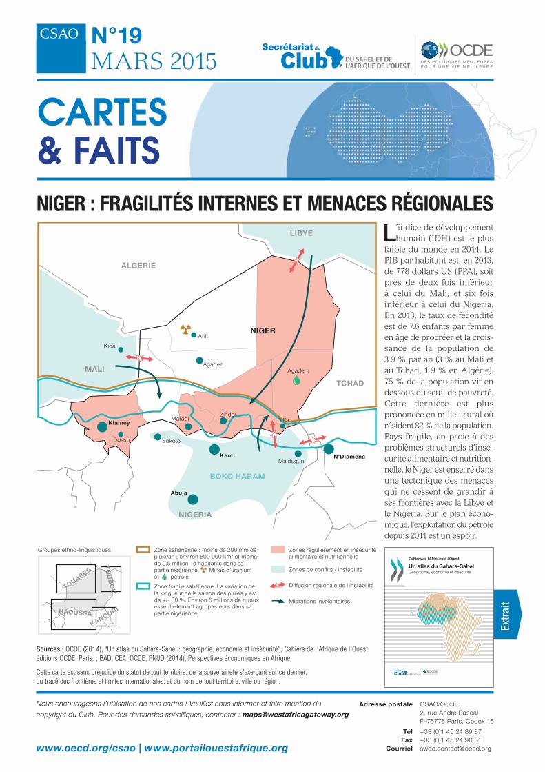
Niger : fragilités iNterNes et meNaces régioNales L’indice de développement
humain (IDH) est le plus faible du monde en 2014. Le PIB par habitant est, en 2013, de 778 dollars US (PPA), soit près de deux fois inférieur à celui du Mali, et six fois inférieur à celui du Nigeria. En 2013, le taux de fécondité est de 7.6 enfants par femme en âge de procréer et la crois-sance de la population de 3.9 % par an (3 % au Mali et au Tchad, 1.9 % en Algérie). 75 % de la population vit en dessous du seuil de pauvreté. Cette dernière est plus prononcée en milieu rural où résident 82 % de la population. Pays fragile, en proie à des problèmes structurels d’insé-curité alimentaire et nutrition-nelle, le Niger est enserré dans une tectonique des menaces qui ne cessent de grandir à ses frontières avec la Libye et le Nigeria. Sur le plan écono-mique, l’exploitation du pétrole depuis 2011 est un espoir.
Sources : OCDE (2014), “Un atlas du Sahara-Sahel : géographie, économie et insécurité”, Cahiers de l’Afrique de l’Ouest, éditions OCDE, Paris. ; BAD, CEA, OCDE, PNUD (2014), Perspectives économiques en Afrique.
LIBYE
NIGER
NIGERIA
TCHAD
MALI
ALGERIE
Arlit
Kidal
BOKO HARAM
Agadez
Zinder
Agadem
DiffaMaradi
SokotoDosso
Niamey
KanoMaïduguri
N’Djaména
Abuja
Zone saharienne : moins de 200 mm de pluie/an ; environ 600 000 km² et moins de 0.5 millions d’habitants dans sa partie nigérienne. Mines d’uranium et pétrole
Groupes ethno-linguistiques
Zone fragile sahélienne. La variation de la longueur de la saison des pluies y est de +/- 30 %. Environ 5 millions de ruraux essentiellement agropasteurs dans sa partie nigérienne.
Zones régulièrement en insécurité alimentaire et nutritionnelle
Zones de conflits / instabilité
Diffusion régionale de l’instabilité
Migrations involontaires
TOUAREG
HAOUSSA
TO
UB
OU
KANOURI