Embed Size (px)
Citation preview

Nick Logan
Nick Logan
Shire of Augusta - Margaret River
PO Box 61
Margaret River WA 6285
22/4/20
Dear Nick
Modified Feedlot Application and D
Please find attached the modified feedlot proposal for the above site.
the removal of clay which will result in an exp
expansion. Plans and documents are attached including most specifically the application
to DWER which comprehensively provides detailed information which is submitted with this
application adjustment as justification. There appeared to be no reason to replicate this information
in a separate report and so this application data is submitted as part of this planning application
adjustment. It should be noted that much of the technical information attached is produced by
DPIRD and this has been modified in consultation
To address the specific queries raised during the ad
With respect to maximum stocking of the feed lot a maximum of 1000 cattle would be within the
feed lot at any given time. Over the period of November to May the throughput of cattle will be
3000. The same of cattle through put is proposed as to what is currently occurring instead there will
be more cattle within the feed lot via this application.
Within the yards area as indicated on the application plans there will be a covered work area of
approximately 10 x 15 metres at approximately 3 metres high. This will effectively be constructed as
a very minor open sided verandah
protect from the elements whether that be the sun or rain. This is indicated on
a simple structure with posts and colour bond/zincalume roof.
With respect to vehicle movements the landowner advises that given the through put of cattle will
not be changing with respect to the new feed lot from the existing feedlot
similar. Traffic expected is described as follows:
• Bringing in of feed will be 60 tonnes of barley per week
Margaret River
and Dam - Lot 100 Treeton Road Cowaramup
Please find attached the modified feedlot proposal for the above site. This includes
lay which will result in an expanded dam. As such the proposal includes this dam
Plans and documents are attached including most specifically the application
to DWER which comprehensively provides detailed information which is submitted with this
n adjustment as justification. There appeared to be no reason to replicate this information
and so this application data is submitted as part of this planning application
It should be noted that much of the technical information attached is produced by
DPIRD and this has been modified in consultation with and with the blessing of DPIRD.
To address the specific queries raised during the advertising period we advise the following:
With respect to maximum stocking of the feed lot a maximum of 1000 cattle would be within the
feed lot at any given time. Over the period of November to May the throughput of cattle will be
le through put is proposed as to what is currently occurring instead there will
be more cattle within the feed lot via this application.
Within the yards area as indicated on the application plans there will be a covered work area of
metres at approximately 3 metres high. This will effectively be constructed as
a very minor open sided verandah/pergola area to provide cover for workers in the yards and to
protect from the elements whether that be the sun or rain. This is indicated on
a simple structure with posts and colour bond/zincalume roof.
With respect to vehicle movements the landowner advises that given the through put of cattle will
not be changing with respect to the new feed lot from the existing feedlot, traffic generation will be
similar. Traffic expected is described as follows:
Bringing in of feed will be 60 tonnes of barley per week – 1 truck per week.
This includes consideration of
ded dam. As such the proposal includes this dam
Plans and documents are attached including most specifically the application document
to DWER which comprehensively provides detailed information which is submitted with this
n adjustment as justification. There appeared to be no reason to replicate this information
and so this application data is submitted as part of this planning application
It should be noted that much of the technical information attached is produced by
DPIRD.
vertising period we advise the following:
With respect to maximum stocking of the feed lot a maximum of 1000 cattle would be within the
feed lot at any given time. Over the period of November to May the throughput of cattle will be
le through put is proposed as to what is currently occurring instead there will
Within the yards area as indicated on the application plans there will be a covered work area of
metres at approximately 3 metres high. This will effectively be constructed as
area to provide cover for workers in the yards and to
protect from the elements whether that be the sun or rain. This is indicated on the plans and will be
With respect to vehicle movements the landowner advises that given the through put of cattle will
, traffic generation will be
1 truck per week.

• Moving of feed from south to north from the existing shed will be via a new machine which
holds 7 tonnes and with typical movement of feed over the week there will be an average of 1 to 3
crossings of the road per day.
• With respect to removal of manure, during summer manure dries off quickly and breaks down
particularly with the onset of dung beetles. As such, the removal of manure is estimated at about 14
cubic metres per week and therefore 1 truck per week to be taken off site which is easy to distribute
or sell as it is in high demand.
• Stock deliveries will be estimated at approximately at 100 per cattle per week which will arrive
in lots of 40 to 50 and therefore 2 trucks per week will be delivered and 2 trucks per week (100
cattle) will be taken away.
• Other farm vehicles movements will be typical to existing activity.
• In summary, the movement of vehicles associated with the use is stated to be similar to
current activity:
1 truck per week for introduction of feed
1 to 3 crossings of the road per day moving of feed
1 truck per week removal of manure
2 trucks per week introduction of stock
2 trucks per week removal of stock
movement of normal farm vehicles
With respect to existing grazing practices on the farm land associated with the feed lot the
landowners are professional graziers and will be buying stock and rearing stock generally on their
farms with many to move through the feed lot. The landowners advise they have 1000 acres
(400ha) available inclusive of their own land and leased land. Feed troughs are installed in some
paddocks to provide effective delivery of feed to cattle in addition to the eating of grass and stubble.
Supporting stock with feed in summer is common practice in grazing when conditions demand and
this is why hay is cut.
The landowners advise they would generally carry around 850 younger cattle (around 200-250kg)
across their 1000 acres between May and December all fed on grass. In the summer/autumn period
when the feedlot is operating the landowners will also buy (when market forces suit) smaller
numbers of larger cattle (400kg) to be held and grazed in paddocks for short periods before entering
the feedlot. These sale yard bought larger summer cattle will clean up stubble in paddocks before
entering the feedlot and be supplemented with some feed if conditions demand. If the feed lot
application of 1000 capacity was approved then the keeping of stock in wider paddocks will decrease
from current activity.
Agriculture WA has adopted stocking guidelines however these generally refer to rural smallholdings
which could be expected to generally provide more conservative guidance than for broad acre
farming properties because rural smallholding farms are smaller and more constrained.
Notwithstanding this, a consideration of these stocking rate guidelines produced by Agriculture WA
has been utilised to assist in advising on this matter. The document is entitled “Stocking Rate
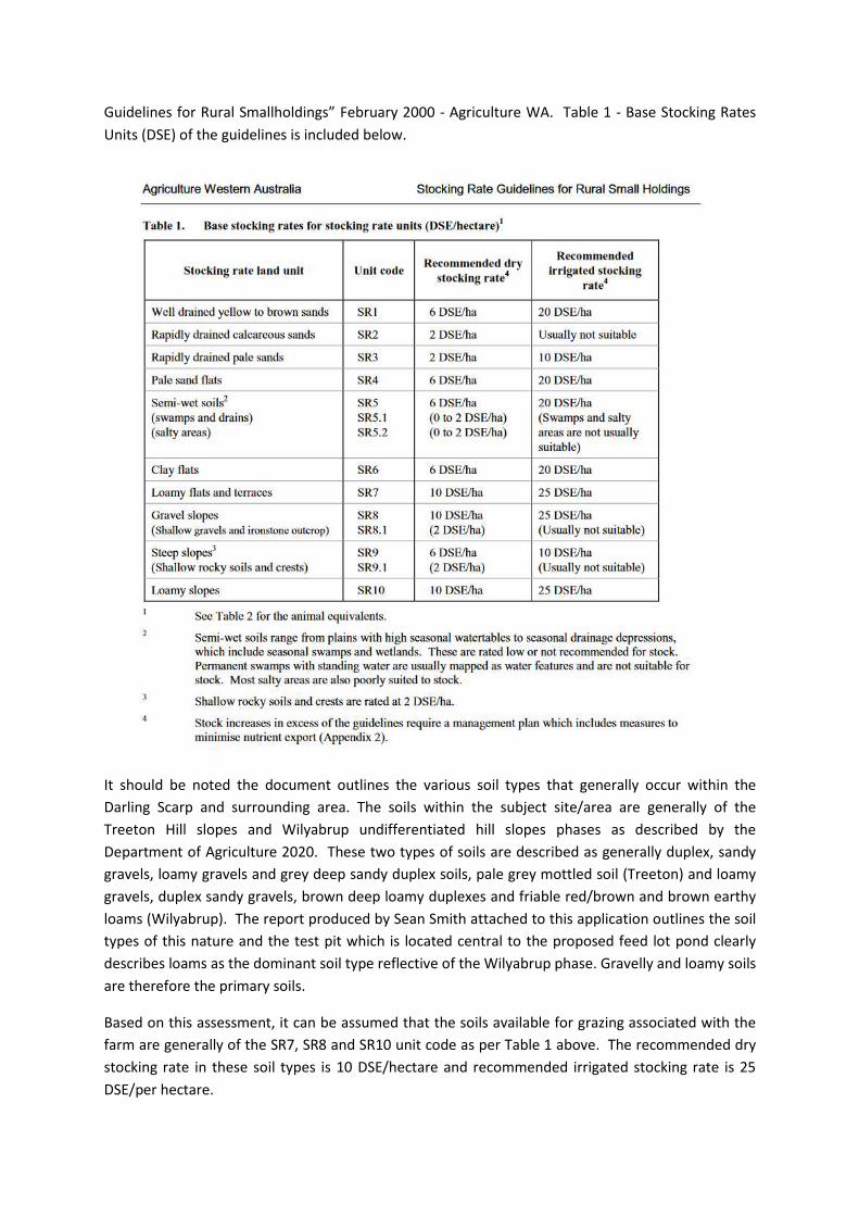
Guidelines for Rural Smallholdings” February 2000 - Agriculture WA. Table 1 - Base Stocking Rates
Units (DSE) of the guidelines is included below.
It should be noted the document outlines the various soil types that generally occur within the
Darling Scarp and surrounding area. The soils within the subject site/area are generally of the
Treeton Hill slopes and Wilyabrup undifferentiated hill slopes phases as described by the
Department of Agriculture 2020. These two types of soils are described as generally duplex, sandy
gravels, loamy gravels and grey deep sandy duplex soils, pale grey mottled soil (Treeton) and loamy
gravels, duplex sandy gravels, brown deep loamy duplexes and friable red/brown and brown earthy
loams (Wilyabrup). The report produced by Sean Smith attached to this application outlines the soil
types of this nature and the test pit which is located central to the proposed feed lot pond clearly
describes loams as the dominant soil type reflective of the Wilyabrup phase. Gravelly and loamy soils
are therefore the primary soils.
Based on this assessment, it can be assumed that the soils available for grazing associated with the
farm are generally of the SR7, SR8 and SR10 unit code as per Table 1 above. The recommended dry
stocking rate in these soil types is 10 DSE/hectare and recommended irrigated stocking rate is 25
DSE/per hectare.
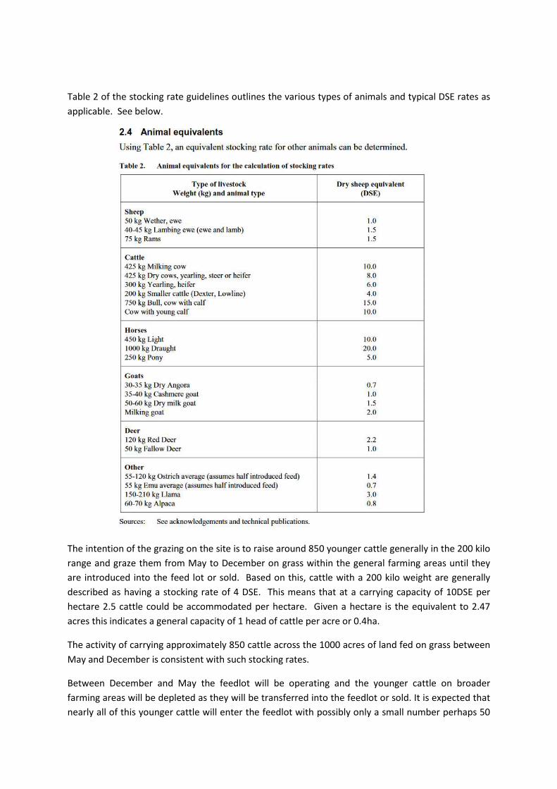
Table 2 of the stocking rate guidelines outlines the various types of animals and typical DSE rates as
applicable. See below.
The intention of the grazing on the site is to raise around 850 younger cattle generally in the 200 kilo
range and graze them from May to December on grass within the general farming areas until they
are introduced into the feed lot or sold. Based on this, cattle with a 200 kilo weight are generally
described as having a stocking rate of 4 DSE. This means that at a carrying capacity of 10DSE per
hectare 2.5 cattle could be accommodated per hectare. Given a hectare is the equivalent to 2.47
acres this indicates a general capacity of 1 head of cattle per acre or 0.4ha.
The activity of carrying approximately 850 cattle across the 1000 acres of land fed on grass between
May and December is consistent with such stocking rates.
Between December and May the feedlot will be operating and the younger cattle on broader
farming areas will be depleted as they will be transferred into the feedlot or sold. It is expected that
nearly all of this younger cattle will enter the feedlot with possibly only a small number perhaps 50

not making it. As such the bringing in of some smaller numbers of larger cattle, (400kg) bought from
the sale yards, will be able to be held in paddocks and clean up stubble for short periods (usually a
few weeks) again before entering the feedlot. Given the carrying of larger cattle would be in the
summer period, support of such cattle would be by way of cleaning up stubble feed in paddocks but
also supplementary feed troughs if conditions require. Given the reared herd will be depleted in
wider paddocks say to around 50 over summer and this would mean there would be adequate
capacity to hold some larger 400kg stock that would have been bought in when market forces were
beneficial. Such larger cattle have a DSE of 8 (as per table 1) which therefore with soils rating at
10DSE/ha could sustain 1.2 head per ha. With the younger cattle at around 50 and requiring around
50 acres or 20ha, there could be stocking area of up to 380ha available for the larger cattle over
summer which would easily accommodate these small number as they a bought. They would
naturally be moved to paddocks to eat available stubble.
The landowner advises the stocking rates in this fashion are generally consistent with farming
stocking rates over summer as also demonstrated typically on dairy farms. Moving stock around
paddocks to take up available feed and stubble and support with hay/feed is common practice.
This stocking capacity is undertaken efficiently and with innovative practices so that the best
outcomes can be achieved on the paddocks available before introducing stock into the feed lot. The
above information therefore indicates that the stocking of the paddocks will be equivalent to typical
stocking rate guidelines that are applicable to rural smallholdings. Given the properties concerned
are notable grazing properties which have been well established over decades it could be argued
that the carrying capacity could be even stronger. The landowner advises that with a larger feedlot
of 1000 capacity, numbers of stock grazing outside the feedlot will decrease from current practices.
The stocking of paddocks is not Animal Husbandry landuse and is therefore consistent with existing
farming activity and not part of the application.
With respect to water availability for the feed lot the owners advise that a 12 million litre annual
licence has been applied for to take water from the northern creek (clay dam area) near the
proposed feed lot. This is on the basis that clay is taken from the existing dam area that would result
in an excavation that would be 50 metres x 50 metres and approximately 4 metres in depth. The
clay will be used to line the feed lot area and pond. The proposal therefore includes expansion os
this dam to support the use. This is shown on the plans. The licence application is currently being
considered by the Department of Water and Environmental Regulation (Busselton branch). The
application plans indicate the resultant excavation of clay and therefore minor expansion to the
existing dam which is reflected in the water licence application.
The average daily drinking water requirement in summer ranges from 50 to 65 L/head/day
depending on feedlot climatic zone and cattle type. (Source: Feedlot Design and Construction
Davis/Watts – MLA.com.au). With a feedlot operation period of November to May and a cooler
climatic zone at Cowaramup, the lower end of this scale could be applied. At 50L/head/day over 212
days at full capacity at all times this would support 1132 head. Assuming a median rate of
57.5L/Head/Day still provides for 1000 head. Full capacity would unlikely be achieved for every day
of the period. This indicates the water license applied for is appropriate for the activity. The dam is
also spring fed and therefore the water rises on the property.

The landowner advises the previous grazing activities on the property have not required licences
from the Department and there are water sources available across the property which have been
exempt for general grazing purposes. It has been common for smaller soaks and dams to be exempt
from licenses to support stock for many years. DWER have indicated that water supplies at 1500kl
for domestic and 8000kl for grazing purposes generally do not require licensing. The existing sources
therefore support the activity. The application for a licence in the north of the site provides
justification for this application with respect to the water supply needed. The landowner has
advised that Location 1740 which is also grazed by them has recently received an 11,000 kilolitre
water licence which supports grazing activity. Further, because the creek is spring fed a license may
actually not be required. This will be determined shortly and within the consideration of this revised
proposal.
The application therefore includes the feedlot, taking of clay and resultant minor expansion of the
dam, the 10x15m weather cover structure, burial pit and other associated works.
Further assessment and reporting has also been prepared by Sean Smith including soil analysis and
test pit in the location of the sedimentation pond at the recommendation of DWER. The results are
favourable showing deep groundwater and good soil types and extra clay source. This information
demonstrates that site conditions are favourable and adequate and good quality clay is available to
line the feedlot and support the environmental management of the use.
DPIRD have calculated the “Separation Distances” that are all compliant and the location of the
feedlot is now cognisant of all known dwelling sites about the subject site.
We would be happy to respond to any queries or provide any additional information if necessary and
please do not hesitate to contact this office for this purpose.
Yours Faithfully
HALSALL & ASSOCIATES
Enc.
DWER application and supporting information
Revised Plans
Report by Landscape and Environmental Management

3m
7m
5m
5m
39m
30m
39m
39m
39m
39m
39m
39m
39m
45m
45m
22.15m
97m
97m
2m
2m
TREETON ROAD
DO
NA
LD
SO
N R
OA
D
1
1
4
1
2
0
1
2
5
1
3
0
1
1
0
1
0
8
1
0
8
1
0
6
1
0
4
1
1
0
1
0
6
1
0
4
1
0
2
1
0
0
1
1
2
1
1
2
1
1
2
1
1
6
1
1
8
1
0
0
Existingdwelling
site 490m
Approveddwelling
site 491m
Existingdwelling
site 690m
Existingdwelling
site 760m
Approveddwelling
site 504m
Pond
Yard
Setback fromroad boundary17
3m
1
0
2
100
100
1
3213
3213
4403
2110
Existing Cellardoor/winery
645m
Clay to be removed from current dam sides (S.W andE) to be used to line feedlot and pond area. Damexpansion to supply water to feedlot and grazing. Damsize expansion 85 x 50 x 5m.
Spillway to return water to creek.
0 100 200 300 400 500
50m
Native earth
Water Bank
Crest
DAM - CROSS SECTIONSCALE 1:500
5m
15m
1
0
2
This concept has been prepared for the purpose of meeting client specifications. The drawing does not
constitute an invitation, agreement or contract (or any part thereof) of any kind whatsoever.
Although care has been taken on the compilation of this document by Halsall & Associates, all parties associated
with the proposed property development disclaim any responsiblity for any errors or omissions. The right is
reserved to change the plan at any time.
Liability is expressly disclaimed by Halsall & Associates for any loss or damage which may be sustained by any
person acting on any visual impression gained from this drawing.
All areas and dimensions shown on this drawing are subject to final survey.
SUBJECT SITE
po box 534
margaret river wa 6285
m 0428569059
YARD
POND
CATTLE RACEWAY
BURIAL PIT
NEARBY DWELLING
FEED TROUGH
Scale:
Date:
Revision No:
Title:
4
1:5000@A3
SITE PLAN FEEDLOT -
LOT 355 TREETON RD,
COWARAMUP
28 APRIL 2020
EXISTING DAM
EXPANSION
COVERED AREA
DAM - Scale 1:2000

3m
7m
5m5m
39m30m 39m 39m 39m
39m 39m 39m 39m
45m45m
22.15m97m
97m
2m2m
1
0
8
15000
10000
0 20 40 60 80 100
3m
2.3m
3m
2.3m
COVERED AREA - SOUTH ELEVATIONSCALE 1:250
COVERED AREA - EAST ELEVATIONSCALE 1:250
Skillion roof (colorbond/zincalume)at 3° pitch
Native earthNative earthNGL
NGL
15m
10m
COVERED AREA
This concept has been prepared for the purpose of meeting client specifications. The drawing
does not constitute an invitation, agreement or contract (or any part thereof) of any kind
whatsoever.
Although care has been taken on the compilation of this document by Halsall & Associates, all
parties associated with the proposed property development disclaim any responsiblity for any
errors or omissions. The right is reserved to change the plan at any time.
Liability is expressly disclaimed by Halsall & Associates for any loss or damage which may be
sustained by any person acting on any visual impression gained from this drawing.
All areas and dimensions shown on this drawing are subject to final survey.
po box 534
margaret river wa 6285
m 0428569059
Scale:
Date:
Revision No:
Title:
2
1:700@A3
FEEDLOT INFRASTRUCTURE -
LOT 355 TREETON RD,
COWARAMUP
22 APRIL 2020
Feed trough
Cattle pen
Sedimentation pond
Feed lane
Cattle raceway
Burial pit
Yard
Pipe
Silt trap
Covered area

112
110
3° fall -water flow
108
Bund
Silt trap
CROSS SECTION - WEST TO EAST
SCALE 1:600
6m
30m 39m 39m 39m 39m 3m 22.15m 2m
213mOverall
Yard
Cattle pen Cattle pen Cattle pen Cattle pen
Sedimentation
pond
2.1m
No groundwater
evidenced at
31 March 2020 -
deeper than 5m.
0 20 40 60 80 100
This concept has been prepared for the purpose of meeting client specifications. The drawing does not constitute an invitation, agreement or contract
(or any part thereof) of any kind whatsoever.
Although care has been taken on the compilation of this document by Halsall & Associates, all parties associated with the proposed property
development disclaim any responsiblity for any errors or omissions. The right is reserved to change the plan at any time.
Liability is expressly disclaimed by Halsall & Associates for any loss or damage which may be sustained by any person acting on any visual impression
gained from this drawing.
All areas and dimensions shown on this drawing are subject to final survey.
Scale:
Date:
Revision No:
Title:
3
1:600@A3
FEEDLOT CROSS SECTION -
LOT 355 TREETON RD,
COWARAMUP
21 APRIL 2020
po box 534
margaret river wa 6285
m 0428569059


Department of Water and Environmental Regulation
Application form: works approval, licence, renewal, amendment, or registration (v12, April 2020) 2 IR-F09 v11.0
Completion Matrix
The matrix below explains what sections are required to be completed for different types of applications.
Application Form Section New Application/
Registration Renewal Amendment
Part 1: Application type ● ● ●
Part 2: Applicant details – sections 2.1 ● ● ●
Part 2: Applicant details – section 2.1 onwards ● ● Δ
Part 3: Premises details ● ● Δ
Part 4: Proposed activities ● ● ●
Part 5: Index of Biodiversity Surveys for Assessment If required. If required. If required.
Part 6: Other DWER approvals ● ● ●
Part 7: Other approvals and consultation ● ● ●
Part 8: Fit and competent operator ● ● Δ
Part 9: Emissions, discharges, and waste ● ● Δ
Part 10: Siting and location ● ● N/A
Part 11: Submission of any other relevant information ● ● If required.
Part 12: Proposed fee calculation ● ● ●
Part 13: Commercially sensitive or confidential information
● ● ●
Part 14: Submission of application ● ● ●
Part 15: Declaration and signature ● ● ●
Attachment 1A: Proof of occupier status ● ● N/A
Attachment 1B: ASIC company extract ● ● N/A
Attachment 1C: Authorisation to act as a representative of the occupier
If required. If required. If required.
Attachment 2: Premises map/s ● ● Δ
Attachment 3A: Proposed activities ● ● Δ
Attachment 3B: Map of area proposed to be cleared (only applicable if clearing is proposed)
● ● ●
Attachment 3C: Additional information for clearing assessment
If required. If required. If required.
Attachment 4: Biodiversity surveys (only applicable if biodiversity surveys included in application)
● ● ●
Attachment 5: Other approvals and consultation documentation
● ● Δ
Attachment 6A: Emissions and discharges If required. If required. If required.
Attachment 6B: Waste acceptance If required. If required. If required.
Attachment 7: Siting and location ● ● Δ
Attachment 8: Additional information submitted If required. If required. If required.
Attachment 9: Proposed fee calculation ● ● ●
Attachment 10: Request for exemption from publication If required. If required. If required.
Key:
● Must be submitted
Δ to the extent changed/required in relation to the amendment
N/A Not required with application, but may be requested subsequently depending on DWER records
“If required” Sections for applicants to determine.

Department of Water and Environmental Regulation
Application form: works approval, licence, renewal, amendment, or registration (v12, April 2020) 3 IR-F09 v11.0
Part 2: Applicant details
INSTRUCTIONS:
The applicant (the occupier of the premises) must be an individual(s), a company, body corporate, or public authority, but not a partnership, trust, or joint-venture name. Applications made by or on behalf of business names or unincorporated associations will not be accepted.
If applying as an individual, your full legal name must be inserted.
If applying as a company, body corporate, or public authority, the full legal entity name must be inserted.
Australian Company Number's (ACN) must be provided for all companies or body corporates.
DWER prefers to send all correspondence electronically via email. We request that you consent to receiving all correspondence relating to instruments and notices under Part V of the EP Act (“Part V documents”) electronically via email, by indicating your consent in Section 2.3.
Companies or body corporates making an application must nominate an authorised representative from within their organisation. Proof of authorisation will be required.
Details of a contact person must be provided for DWER enquiries in relation to your application. This contact person can be a consultant if authorised to represent the applicant. Written evidence of this authorisation must be provided.
Details of the occupier of the premises must be provided. One of the options must be selected and if you have been asked to specify, please provide details. For example, if ‘lease holder’ has been selected, please specify the type of lease (for example, pastoral lease, mining lease, or general lease) and provide a copy of the lease document(s). Note that contracts for sale of land will not be sufficient evidence of occupancy status.
2.1 Applicant name/s (full legal name/s):
[the proposed holder of the works approval, licence or registration]
GJ & J Watt
ACN (if applicable): N/A
2.2 Trading as (if applicable): Kachana Trust
2.3 Authorised representative details:
[the person authorised to receive correspondence and Part V documents on behalf of the applicant under the EP Act.
Where ‘yes’ is selected, all correspondence will be sent to you via email, to the email address provided in this section.
Where ‘no’ has been selected, Part V documents will be posted to you in hard copy to the postal / business address specified in section 2.4. Other general correspondence may still be sent to you via email.]
Name Lee Watt (son of Gavin Watt)
Position Manager
Telephone 0429110024
Email [email protected]
I consent to all written correspondence between myself (the applicant) and DWER, regarding the subject of this application, being exclusively via email, using the email address I have provided above.
Yes No
2.4 Registered business address for receipt of Part V documents under the EP Act:
[this must be a physical address to which a Part V document may be delivered.
355 Treeton Road, Cowaramup WA 6284
2.5 Postal address for all other correspondence:
[if different from section 2.4]
PO Box 54 Cowaramup WA 6284

Department of Water and Environmental Regulation
Application form: works approval, licence, renewal, amendment, or registration (v12, April 2020) 4 IR-F09 v11.0
Part 2: Applicant details
2.6 Contact person details for DWER enquiries relating to the application (if different from the authorised representative):
[for example, could be a consultant or a site based employee]
Name Marc Halsall
Position Managing Director
Organisation Halsall & Associates
Address Unit 1/23 Fearn Avenue MARGARET RIVER WA 6285
(PO Box 29 MARGARET RIVER WA 6285)
Telephone 0428 222 323 – Marc Halsall
Email [email protected]
2.7 Occupier status:
[Occupier is defined in section 3 of the EP Act and includes a person in occupation or control of the premises, or occupying a different part of the premises whether or not that person is the owner.]
Registered proprietor on certificate of title
Lease holder (please specify, including date of expiry of lease)
Public authority that has care, control or management of the land
Other (please specify – for example, joint venture operating entity, contract, or other legal document)
Attachments N/A Yes
2.8 Attachment 1A: Proof of occupier status
Copies of certificate of title, lease or other instruments evidencing proof of occupier status, including the expiry date or confirmation that there is no expiry date, have been provided and labelled as Attachment 1A.
2.9 Attachment 1B: ASIC company extract
A current company information extract purchased from the ASIC website(s) for all new applications/registrations has been provided and labelled as Attachment 1B.
2.10 Attachment 1C: Authorisation to act as representative of the occupier
A copy of the documentation authorising the applicant to act on the occupier’s behalf as their authorised agent/representative has been provided and labelled as Attachment 1C.

Department of Water and Environmental Regulation
Application form: works approval, licence, renewal, amendment, or registration (v12, April 2020) 5 IR-F09 v11.0
Part 3: Premises details
3.1 Premises legal description (whole or part to be specified):
[Include the land description (volume and folio number, lot or location number/s); Crown lease or reserve number; pastoral lease number; or mining tenement number (as appropriate), of all properties, as shown on title details registered with Landgate.]
Lot 100 on Deposited Plan 400608
Premises street address
[Include the suburb.] 355 Treeton Road, COWARAMUP
Premises name (if applicable): N/A
3.2 Local Government Authority area:
[City, Town or Shire] Shire of Augusta-Margaret River
3.3 GPS or map coordinates:
[GPS coordinates (latitude and longitude) must be provided where cadastre or mining tenements are not used as the premises boundary]
See Section 10: Maps in Attachment 3A
Attachments N/A Yes
3.4 Attachment 2: Premises map/s
An aerial photograph, map and site plan of the premises must be included as an attachment to this application form and labelled Attachment 2.
You must provide an aerial photograph of sufficient scale showing the prescribed premises.
You must also provide a map or maps of the prescribed premises, identifying:
layout of key infrastructure and buildings, clearly labelled;
the premises boundary;
emission and discharge points (with GPS coordinates where available);
sensitive receptors and land uses; and
all areas proposed to be cleared (if applicable).
Maps must contain a north arrow, clearly marking the area in which the activities are carried out. The map or maps must be of reasonable clarity and have a visible scale.

Department of Water and Environmental Regulation
Application form: works approval, licence, renewal, amendment, or registration (v12, April 2020) 6 IR-F09 v11.0
Part 4: Proposed activities
INSTRUCTIONS:
You must provide a description and the scope, size and scale of all prescribed activities of Schedule 1 to the EP Regulations including the maximum production or design capacity of each prescribed activity.
If applying for a works approval or licence amendment involving the construction of new infrastructure, you must provide information on infrastructure to be constructed and how long construction is expected to take. You must confirm if commissioning is to occur and how long it will take.
If applying for a works approval or licence amendment not involving the construction of new infrastructure, provide details of the proposed amendment.
You must identify all emission sources on the premises map/s.
You must also provide information on activities which directly relate to the prescribed premises category which have, or are likely to result in, an emission or discharge.
If clearing activities are proposed provide a description and details. If a relevant exemption under Schedule 6 of the EP Act or regulation 5 of the Environmental Protection (Clearing of Native Vegetation) Regulations 2004 (WA) (Clearing Regulations) may apply, provide details.
4.1 Description/overview:
This is an application for a works approval to construct a beef cattle feedlot with a capacity of 1000 head. The works approval details the construction of eight feedlot pens, cattle yards, feed lane, drains, silt trap and evaporation pond. Refer to Attachment 3A for additional information. Following the construction of the works associated with this application, a compliance report will be submitted and an application for a license will be lodged.
4.2 Estimated operating period of the project / premises (e.g. based on estimated infrastructure life):
30 years
4.3 Proposed date/s for commencement of works (if applicable):
As soon as a works approval is granted (preferably by MayJune 2020)
4.4 Proposed date/s for conclusion of works construction (if applicable):
[This date should coincide with the submission to DWER of an Environmental Compliance Report and/or a Critical Containment Infrastructure Reports as required]
Six months after works approval is granted (notionally September 2020)
4.5 Proposed date/s for commissioning of works (if applicable): N/A
4.6 Proposed date/s for commencement of operations under works approval (if applicable):
As soon as practicable.
4.7 Maximum production or design capacity for each category applied for (based on infrastructure operating 24 hours a day, 7 days a week):
[Refer to categories listed in 1.2. Units must be consistent with Schedule 1 of the EP Regulations]
Category 1 - 1000 head
Category 23 – 3000 tonnes
4.8 Estimated/actual throughput for each category applied for:
[Refer to categories listed in 1.2. Units must be consistent with Schedule 1 of the EP Regulations]
Category 1 - 3000 head yearly throughput with no more than 1000 head in the feedlot at any time
Category 23 – 1800 tonnes
4.9 Proposed activities:
You must provide details of proposed activities, identifying:
scope, size and scale, including details as to frequency and production or design capacity;
key infrastructure and equipment;
description of processes or operations (a process flow chart may be included as an attachment);
emission/discharge points;
locations of waste storage or disposal; and
activities occurring during construction, commissioning and operation (if applicable). Additional information relating to the proposed activities may be included in Attachment 3A (see 4.10 below).
See Attachment 3A
Attachments N/A Yes

Department of Water and Environmental Regulation
Application form: works approval, licence, renewal, amendment, or registration (v12, April 2020) 7 IR-F09 v11.0
Part 4: Proposed activities
4.10 Attachment 2: Premises map
Emission/discharge points are clearly labelled on the map/s required for Part 3.4 (Attachment 2).
4.11 Attachment 3A: Proposed activities
Additional information relating to the proposed activities has been included in Attachment 3A (if required).
Clearing activities
[4.12 to 4.18 are only required if the application includes clearing of native vegetation]
4.12 Proposed clearing area (hectares and/or number of individual trees to be removed):
No clearing is required given the area of feed lot is cleared land.
4.13 Details of any relevant exemptions:
[refer to DWER’s A guide to the exemptions and regulations for clearing native vegetation]
N/A
4.14 Proposed method of clearing: N/A
4.15 Period within which clearing is proposed to be undertaken:
[for example, May 2019 – June 2019]
N/A
4.16 Purpose of clearing:
N/A
Clearing activities – Attachments N/A Yes
4.17 Attachment 3B: Map of area proposed to be cleared
You must provide an aerial photograph or map of sufficient scale showing the proposed clearing area and prescribed premises boundary
OR
if you have the facilities, a suitable portable digital storage device of the area proposed to be cleared as an ESRI shapefile with the following properties:
Geometry type: Polygon Shape
Coordinate system: GDA 1994 (Geographic latitude/longitude)
Datum: GDA 1994 (Geocentric Datum of Australia 1994).
N/A
4.18 Attachment 3C: Additional information for clearing assessment
Additional information to assist in the assessment of the clearing proposal may be attached to this application (for example, reports on salinity, fauna or flora studies or other environmental reports conducted for the site).
N/A
Part 5: Index of Biodiversity Surveys for Assessments (IBSA)
INSTRUCTIONS:
Biodiversity surveys submitted to support this application must meet the requirements of the EPA’s Instructions for the preparation of data packages for the Index of Biodiversity Surveys for Assessments (IBSA).
If these requirements are not met, DWER will decline to deal with the application.
Attachments N/A Yes
5.1 Attachment 4:
Biodiversity surveys
All biodiversity surveys submitted with this application meet the requirements of the EPA’s Instructions for the preparation of data packages for the Index of Biodiversity Surveys for Assessments (IBSA).

Department of Water and Environmental Regulation
Application form: works approval, licence, renewal, amendment, or registration (v12, April 2020) 8 IR-F09 v11.0
Part 6: Other DWER approvals
INSTRUCTIONS:
If you have applied, or intend to apply, for other approvals within DWER that may be relevant to this application, you must provide relevant details.
If you have referred, or intend to refer, your proposal to the Environmental Protection Authority (EPA), you must provide details.
Pre-application scoping
6.1 Have you had any pre-application / pre-referral / scoping meetings with DWER regarding any planned applications?
No
Yes – provide details: [Gavin Watt has met informally with both Caron Goodbourne and Cathie Derrington]l Marc Halsall has also had detailed discussions with Caron Goodbourne and various emails exchanged.
Environmental Impact Assessment (Part IV of the EP Act)
6.2 Have you referred or do you intend to refer the proposal to the EPA?
Section 37B(1) of the EP Act defines a ‘significant proposal’ as “a proposal likely, if implemented, to have a significant effect on the environment”.
If DWER considers that the proposal in this application is likely to constitute a ‘significant proposal’, DWER is required under section 38(5) of the EP Act to refer the proposal to the EPA for assessment under Part IV, if such a referral has not already been made.
If a relevant Ministerial Statement already exists, please provide the MS number in the space provided.
Yes (referred) – reference (if known): [ ]
Yes – intend to refer (proposal is a ‘significant proposal’)
Yes – intend to refer (proposal will require a section 45C amendment to the current Ministerial Statement): MS [ ]
No – a valid Ministerial Statement applies: MS [ ]
No – not a ‘significant proposal’
Clearing of Native Vegetation (Part V, Division 2 of the EP Act and Country Area Water Supply Act 1947)
6.3 Have you applied or do you intend to apply for a native vegetation clearing permit?
In accordance with the Guidance Statement: Decision Making, where clearing of native vegetation is of an exempt kind under the Environmental Protection (Clearing of Native Vegetation) Regulations 2004 (WA), or is being assessed by a relevant authority which would lead to an exemption under Schedule 6 of the EP Act, the clearing will not be assessed by DWER or be subject to any additional controls by DWER.
If the proposed clearing action is to be assessed in accordance with, or under, an Environment Protection and Biodiversity Conservation Act 1999 (Cth) (EPBC Act) accredited process, such as the assessment bilateral agreement, Form Annex C7 – Assessment bilateral agreement must be completed and attached to your clearing permit application.
Yes – clearing application reference (if known): [ ]
No – this application includes clearing (please complete questions 4.11 to 4.17)
No – a valid permit applies: CPS [ ]
No – exemption applies (explain why): [ ]
No – permit not required
6.4 Have you applied or do you intend to apply for a Country Area Water Supply Act 1947 licence?
If a clearing exemption applies in a Country Area Water Supply Act 1947 (CAWS) controlled catchment, or if compensation has previously been paid to retain the subject vegetation, a Country Area Water Supply Act 1947 clearing licence is required.
If yes, contact the nearest DWER regional office for a Form 1 Application for licence.
Map of CAWS Act controlled catchments
Yes – application reference (if known): [ ]
No – a valid licence applies: [ ]
No – licence not required

Department of Water and Environmental Regulation
Application form: works approval, licence, renewal, amendment, or registration (v12, April 2020) 9 IR-F09 v11.0
Part 6: Other DWER approvals
Water Licences and Permits (Rights in Water and Irrigation Act 1914)
6.5 Have you applied, or do you intend to apply for:
1. a licence or amendment to a licence to take water (surface water or groundwater); or
2. a licence to construct wells (including bores and soaks); or
3. a permit or amendment to a permit to interfere with the bed and banks of a watercourse?
Yes –application reference (if known): [ ]
No – a valid licence / permit applies: [ ]
No – licence / permit not required
With respect to water availability for the feed lot the owners advise that a 12 million litre annual licence has been applied for to take water from the northern creek (clay dam area) near the proposed feed lot. This is on the basis that clay is taken from the existing dam area that would result in an excavation that would be 50 metres x 50 metres and approximately 4 metres in depth. The clay will be used to line the feed lot area and pond. This is shown on the plans. The licence application is currently being considered by the Department of Water and Environmental Regulation (Busselton branch). The application plans indicate the resultant excavation of clay and therefore minor expansion to the existing dam which is reflected in the water licence application.
The average daily drinking water requirement in summer ranges from 50 to 65 L/head/day depending on feedlot climatic zone and cattle type. (Source: Feedlot Design and Construction Davis/Watts – MLA.com.au). With a feedlot operation period of November to May and a cooler climatic zone at Cowaramup, the lower end of this scale could be applied. At 50L/head/day over 212 days this would support 1132 head. Assuming a median rate of 57.5L/Head/Day still provides for 1000head. This indicates the water license applied for is appropriate for the activity.
The landowner advises the previous grazing activities on the property have not required licences from the Department and there are water sources available across the property, which have been exempt for general grazing purposes. It has been common for smaller soaks and dams to be exempt from licenses to support stock for many years. 1500kl is commonly accepted for domestic purposes and 8000kl for grazing. The existing sources therefore support the activity. The application for a licence in the north of the site provides justification for this application with respect to the water supply needed. The landowner has advised that Location 1740 which is also grazed by them has recently received an 11,000 kilolitre water licence which supports grazing activity.
Part 7: Other approvals and consultation
INSTRUCTIONS:
Please provide copies of all relevant documentation indicated below, including any conditions, exclusions, or expiry dates.
Major Project means:
A State Development Project, where the lead agency is the Department of Jobs, Tourism, Science and Innovation (including projects to which a State Agreement applies); or
A Level 2 or 3 Major Resource Project, as defined in the Lead Agency Framework.
N/A No Yes
7.1 Is the proposal a Major Project?
7.2 Is the proposal subject to a State Agreement Act?
If yes, specify which Act:

Department of Water and Environmental Regulation
Application form: works approval, licence, renewal, amendment, or registration (v12, April 2020) 10 IR-F09 v11.0
Part 7: Other approvals and consultation
7.3 Has the proposal been allocated to a “Lead Agency”?
If yes, specify Lead Agency contact details:
7.4 Has the proposal been referred and/or assessed under the EPBC Act (Commonwealth)?
If yes, please specify referral, assessment and/or approval number:
7.5 Has the proposal obtained all relevant planning approvals?
If planning approval is necessary but has not been obtained, please provide details indicating why:
An application for planning approval to the Shire has been submitted, with a request to amend the original application. The Shire will be considering the adjusted location for the feed lot with the same information provided as is included within this document.
If planning approval is not necessary, please provide details indicating why:
7.6 For renewals or amendment applications, are the relevant planning approvals still valid (that is, not expired)?
7.7 Has the proposal obtained all other necessary statutory approvals (not including any other DWER approvals identified in Part 6)?
If no, please provide details of approvals already obtained, outstanding approvals, and expected dates for obtaining these outstanding approvals:
Planning approval applied for concurrently.
N/A No Yes
7.8 Has consultation been undertaken with parties considered to have a direct interest in the proposal (that is, interested parties or persons who are considered to be directly affected by the proposal)?
DWER will give consideration to submissions from interested parties or persons in accordance with the Guidance Statement: Decision Making.
Attachments N/A Yes
7.9 Attachment 5: Other approvals and consultation documentation
Details of other approvals specified in Part 7 of this application, including copies of relevant decisions and any consultation undertaken with direct interest stakeholders have been provided and labelled Attachment 5.
Part 8: Applicant history
Note:
Under this section, DWER will undertake an internal due diligence of the applicant’s fitness and competency based on DWER’s compliance records.
If you wish to provide additional information for DWER to consider in making this assessment, you may provide that information as a separate attachment (see Part 11).
N/A No Yes
8.1 If the applicant is an individual, has the applicant previously held, or do they currently hold, a licence or works approval under Part V of the EP Act?
8.2 If the applicant is a corporation, has any director of that corporation previously held, or do they currently hold, a licence or works approval under Part V of the EP Act?

Department of Water and Environmental Regulation
Application form: works approval, licence, renewal, amendment, or registration (v12, April 2020) 11 IR-F09 v11.0
Part 8: Applicant history
8.3 If yes to 8.1 or 8.2 above, specify the name of company and/or licence or works approval number:
8.4 If the applicant is an individual, has the applicant ever been convicted, or paid a penalty, for an offence under a provision of the EP Act, its subsidiary legislation, or similar environmental protection or health-related legislation in Western Australia or elsewhere in Australia?
8.5 If the applicant is a corporation, has any director of that corporation ever been convicted, or paid a penalty, for an offence under a provision of the EP Act, its subsidiary legislation, or similar environmental protection or health-related legislation in Western Australia or elsewhere in Australia?
8.6 If the applicant is a corporation, has any person concerned in the management of the corporation, as referred to in section 118 of the EP Act, ever been convicted of, or paid a penalty, for an offence under a provision of the EP Act, its subsidiary legislation, or similar environmental protection or health-related legislation in Western Australia or elsewhere in Australia?
8.7 If the applicant is a corporation, has any director of that corporation ever been a director of another corporation that has been convicted, or paid a penalty, for an offence under a provision of the EP Act, its subsidiary legislation, or similar environmental protection or health-related legislation in Western Australia or elsewhere in Australia?
8.8 With regards to the questions posed in 8.4 to 8.7 above, have any legal proceedings been commenced, whether convicted or not, against the applicant for an offence under a provision of the EP Act, its subsidiary legislation, or similar environmental protection or health-related legislation in Western Australia or elsewhere in Australia?
8.9 Has the applicant had a licence or other authority suspended or revoked due to a breach of conditions or an offence under the EP Act or similar environmental protection or health-related legislation in Western Australia or elsewhere in Australia?
8.10 If the applicant is a corporation, has any director of that corporation ever had a licence or other authority suspended or revoked due to a breach of conditions or an offence under the EP Act or similar environmental protection or health-related legislation in Western Australia or elsewhere in Australia?
8.11 If the applicant is a corporation, has any director of that corporation ever been a director of another corporation that has ever had a licence or other authorisation suspended or revoked due to a breach of conditions or an offence under the EP Act or similar environmental protection or health-related legislation in Western Australia or elsewhere in Australia?
8.12 If yes to any of 8.4 to 8.11 above, you must provide details of any charges, convictions, penalties paid for an offence, and/or licences or other authorisations suspended or revoked:

Department of Water and Environmental Regulation
Application form: works approval, licence, renewal, amendment, or registration (v12, April 2020) 12 IR-F09 v11.0
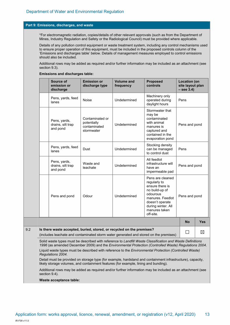
Part 9: Emissions, discharges, and waste
INSTRUCTIONS:
Please see Guidance Statement: Risk Assessments and provide all information relating to emission sources, pathways and receptors relevant to the application.
You must provide details on sources of emissions (for example, kiln stack, baghouses or discharge pipelines) including fugitive emissions (for example, noise, dust or odour), types of emissions (physical, chemical, or biological), and volumes, concentrations and durations of emissions.
The potential for emissions should be considered for all stages of the proposal (where relevant), including during construction, commissioning and operation of the premises.
No Yes
9.1 Are there potential emissions or discharges arising from the proposed activities?
If yes, identify all potential emissions and discharges arising from the proposed activities and complete the Emission Table below.
Gaseous and particulate emissions (e.g. emissions from stacks, chimneys or baghouses)
Dust (e.g. from equipment, unsealed roads and/or stockpiles)
Wastewater discharges (e.g. treated sewage, wash water, or process water discharged to lands or waters)
Waste and leachate (e.g. emissions through seepage, leaks and spills of waste from storage, process and handling areas)
Noise (e.g. from machinery operations and/or vehicle operations)
Odour (e.g. from wastes accepted at putrescible landfills)
Contaminated or potentially contaminated stormwater (e.g. stormwater with the potential to come into contact with chemicals or waste materials)
Electromagnetic radiation*
Other (please specify) [ ]
Department of Water and Environmental Regulation
Application form: works approval, licence, renewal, amendment, or registration (v12, April 2020) 13 IR-F09 v11.0
Part 9: Emissions, discharges, and waste
*For electromagnetic radiation, copies/details of other relevant approvals (such as from the Department of Mines, Industry Regulation and Safety or the Radiological Council) must be provided where applicable.
Details of any pollution control equipment or waste treatment system, including any control mechanisms used to ensure proper operation of this equipment, must be included in the proposed controls column of the ‘Emissions and discharges table’ below. Details of management measures employed to control emissions should also be included.
Additional rows may be added as required and/or further information may be included as an attachment (see section 9.3).
Emissions and discharges table:
Source of emission or discharge
Emission or discharge type
Volume and frequency
Proposed controls
Location (on site layout plan – see 3.4)
Pens, yards, feed lanes
Noise Undetermined Machinery only operated during daylight hours
Pens
Pens, yards, drains, silt trap and pond
Contaminated or potentially contaminated stormwater
Undetermined
Stormwater that may be contaminated with animal manures is captured and contained in the evaporation pond
Pens and pond
Pens, yards, feed lanes
Dust Undetermined Stocking density can be managed to control dust
Pens
Pens, yards, drains, silt trap and pond
Waste and leachate
Undetermined
All feedlot infrastructure will have an impermeable pad
Pens and pond
Pens and pond Odour Undetermined
Pens are cleaned regularly to ensure there is no build-up of odourous manures. Feedlot doesn’t operate during winter. All manures taken off-site.
Pens and pond
No Yes
9.2 Is there waste accepted, buried, stored, or recycled on the premises?
(includes leachate and contaminated storm water generated and stored on the premises)
Solid waste types must be described with reference to Landfill Waste Classification and Waste Definitions 1996 (as amended December 2009) and the Environmental Protection (Controlled Waste) Regulations 2004.
Liquid waste types must be described with reference to the Environmental Protection (Controlled Waste) Regulations 2004.
Detail must be provided on storage type (for example, hardstand and containment infrastructure), capacity, likely storage volumes, and containment features (for example, lining and bunding).
Additional rows may be added as required and/or further information may be included as an attachment (see section 9.4).
Waste acceptance table:

Department of Water and Environmental Regulation
Application form: works approval, licence, renewal, amendment, or registration (v12, April 2020) 14 IR-F09 v11.0
Part 9: Emissions, discharges, and waste
Waste type Quantity (e.g. tonnes, litres, cubic metres)
Storage infrastructure (including specifications)
Monitoring (if applicable)
Location (on site layout plan – see 3.4)
Wastewater
Surface area of 2151m
2 and a
depth of 2.1m = maximum volume of 4500m
3
(4.5ML)
Pond Daily Labelled as pond
Deceased animals
10 animals/year Burial pit Weekly Labelled as burial pit
Attachments N/A Yes
9.3 Attachment 6A: Emissions and discharges (if required)
If required, further information for Part 9.1 has been included as an attachment labelled Attachment 6A.
9.4 Attachment 6B: Waste acceptance (if required)
If required, further information for Part 9.2 has been included as an attachment labelled Attachment 6B.
Part 10: Siting and Location
10.1 What is the distance to the nearest sensitive land uses (that is, a residence or other land use which may be affected by an emission or discharge associated with the proposed activities):
645 metres to a public use area (Tassell Park Wines currently closed) and 490 metres to the nearest residence.
No Yes
10.2 Is the premises located within, or within close proximity to, any specified ecosystems, or any environmentally sensitive areas (ESAs) as declared under the Environmental Protection (Environmentally Sensitive) Notice 2005?
(See Guidance Statement: Environmental Siting)
If no, identify the distance in which there are no specified ecosystems and/or ESAs. If yes, provide details of the specified ecosystems and/or ESAs, and the distance to these:
The proposed location of the feedlot looks to be located within a RIWI surface water irrigation area and a proclaimed groundwater area.
10.3 If yes to 10.2, you must also provide further information including details on topography, geology, soil type, depth to groundwater and quality of groundwater at the premises.
For premises answering no to 10.2, additional information including topography, geology, soil type, groundwater depth, and water quality is recommended to be included if this information is available.

Department of Water and Environmental Regulation
Application form: works approval, licence, renewal, amendment, or registration (v12, April 2020) 15 IR-F09 v11.0
Part 10: Siting and Location
The revised location for the feed lot is located within the Wilyabrup Slopes (W) soils classification of the Wilyabrup Valleys Land System (Tille & Lantzke Agriculture 1990). A map indicating this is included below. These are described as slopes with gentle gradients generally 5 to 15% but ranging from 2 to 30% and containing gravelly soils (ie Forest Grove and Keenan soils).
Notwithstanding the intention is to clay line the feedlot and pond so that water does not escape into the water table and this is assisted by the fact the activity will not occur in winter, a depth to water table was checked at the location of the proposed pond. This was following discussion with Caron Goodbourne (DWER). A pit was dug to 5 metres in depth at the location of the pond and there was no groundwater evidenced in the pit. Given the feedlot is on a hill it is expected groundwater levels will be better the further west from the pit through the feedlot. A report and description of the pit, groundwater, checks and other information was prepared by Sean Smith of Landscape and Environmental Management. This is attached to support the proposal.
The contours of the new location are evident on the plan excerpt below.
As evident above the contours of the site range from approximately 114AHD in the NW corner to 108AHD in the North East corner of the feedlot. This is therefore a decrease of 6 metres over a distance of approximately 200mmetres representing a 3 degree slope. The intent is to undertake earthworks so the soil contoured with a consistent slope downhill from WSW to ENE as indicatively depicted above and thus the overland flow will be directed to the pond which will be cambered to the north so that any flow that might occur would be toward the north and the paddocks in that area. This was suggested as suitable by officers of DWER.
Also in the area of the feedlot and as indicated in the report by Sean Smith attached, there are other clay soils available which have been tested and this provides a further source to clay to line the feedlot and pond in addition to the clay available from the drainage area in the north (referred to elsewhere in this report).
Attachments N/A Yes

Department of Water and Environmental Regulation
Application form: works approval, licence, renewal, amendment, or registration (v12, April 2020) 16 IR-F09 v11.0
Part 10: Siting and Location
10.4 Attachment 7: Siting and location
You must provide details and a map describing the siting and location of the premises, including identification of distances to sensitive land uses and/or any specified ecosystems.
See attached and included in this report
Part 11: Submission of any other relevant information
Attachments No Yes
11.1 Attachment 8: Additional information submitted
Applicants seeking to submit further information may include information labelled Attachment 8. If submitting multiple additional attachments, label them 8A, 8B, etc.
Where supplementary documentation is submitted, please specify the name of documents below.
List title of supplementary document/s attached: Soil Assessment and Groundwater Report – by Landscape and Environmental Management
Part 12: Proposed fee calculation
INSTRUCTIONS:
To pay a fee via BPoint, or for information for paying via secure electronic funds transfer or cheque, consult DWER’s website at https://dwer.wa.gov.au/make-a-payment. If paying by credit card, select biller code “Industry Regulation”.
Fee calculators are available online to assist in completing this section.
Licence: www.der.wa.gov.au/LicenceFeeCalculator
Works approval: www.der.wa.gov.au/WorksApprovalFeeCalculator
Amendment:: www.der.wa.gov.au/AmendmentFeeCalculator
Different fee units apply for different fee components. Fee units may also have different amounts depending on the period in which the calculation is made.
Further information on fees can be found in the Fact Sheet: Industry Regulation fees, available from DWER’s website.
12.1 Only the relevant fee calculations are to be completed as follows:
[mark the box to indicate sections completed]
Section 12.3 for works approval applications
Section 12.4 for licence applications
Section 12.5 for registration applications
Section 12.6 for amendment applications
Section 12.7 for applications requiring clearing of native vegetation
12.2 All information and data used for the calculation of proposed fees has been provided in accordance with section 12.8.
12.3 Proposed works approval fee
Proposed works approval fee (see Schedule 3 of the EP Regulations)
Fees relate to the cost of the works, including all capital costs (inclusive of GST) associated with the construction and establishment of the works proposed under the works approval application. This includes, for example, costs associated with earth works, hard stands, drainage, plant hire, equipment, processing plant, relocation of equipment and labour hire.
Costs exclude:
- the cost of land;
- the cost of buildings to be used for purposes unrelated to the purposes in respect of which the premises are, or will become, prescribed premises; costs for buildings unrelated to the prescribed premises activity or activities; and
- consultancy fees relating to the works.
Fee component Proposed fee
Cost of works: $ 67,000 $ 1421 (requested waiver due to adjustment to application)

Department of Water and Environmental Regulation
Application form: works approval, licence, renewal, amendment, or registration (v12, April 2020) 17 IR-F09 v11.0
12.4 Proposed licence fee
Detailed licence fee calculations
Part 1 Premises component (see regulation 5D and Part 1 of Schedule 4 of the EP Regulations)
The production or design capacity should be the maximum capacity of the premises. For most categories the production or design capacity refers to an annual rate. The figure should be based on 24 hour operation for 365 days, unless there is another regulatory approval or technical reason that restricts operation.
The premises component fee applies to the category in Part 1, Schedule 4 incurring the higher or highest amount of fee units in accordance with regulation 5D(2) of the EP Regulations.
List all categories (insert additional rows as required). Use only the higher or highest amount of fee units to determine the Part 1 fee component.
Category Production or design capacity Fee units
Using the higher or highest amount of fee units, Part 1 component subtotal $
Part 2 Waste (see regulation 5D(1a)(b) and Part 2 of Schedule 4 of the EP Regulations)
If your premises includes one or more of the following categories specify any applicable Part 2 waste amounts. Do not include Part 3 waste components of these discharges in the below sections.
Categories: 5, 6, 7, 8, 9, 12, 14, 44, 46, 53, 54A, 70, 80, or 85B
Part 2 waste means waste consisting of –
(a) tailings; or
(b) bitterns; or
(c) water to allow mining of ore; or
(d) flyash; or
(e) waste water from a desalination plant.
If the premises does not fall into one of the categories listed above, or there are no applicable Part 2 waste amounts, the sub total for this section will be $0.
Insert additional rows as required. Sum all Part 2 waste fees to determine the sub total.
Discharge quantity (tonnes/year) Fee units
Part 2 component subtotal $
Part 3 Waste - Discharges to air, onto land, into waters (see Part 3 of Schedule 4 of the EP Regulations)
Choose the appropriate location of the discharge and enter the discharge amount(s) in the units specified in the EP Regulations. This should be the amount of waste expected to be discharged over the next 12 months, expressed in the units and averaging period applicable for that waste kind (for example, g/minute or kg/day). Amounts can be measured, calculated, or estimated and can be based on data acquired over the previous 12 months, but should be based on the maximum premises capacity and not the forecast operating hours.
Where there are discharges, all prescribed waste types must be considered in the fee calculation. If a specified waste type is not present in the discharge, this must be justified using an appropriate emission estimation technique (for example, sampling data, industry sector guidance notes, National Pollution Inventory guides and emission factors).

Department of Water and Environmental Regulation
Application form: works approval, licence, renewal, amendment, or registration (v12, April 2020) 18 IR-F09 v11.0
Discharges to air
Discharges to air Discharge rate (g/min)
Discharges to air Discharge rate (g/min)
Carbon monoxide Nickel
Oxides of nitrogen Vanadium
Sulphur oxides Zinc
Particulates (Total PM) Vinyl chloride
Volatile organic compounds Hydrogen sulphide
Inorganic fluoride Benzene
Pesticides Carbon oxysulphide
Aluminium Carbon disulphide
Arsenic Acrylates
Chromium Beryllium
Cobalt Cadmium
Copper Mercury
Lead TDI (toluene-2, 4-di-iso-cyanate)
Manganese MDI (diphenyl-methane di-iso-cyanate)
Molybdenum Other waste
Part 3 component subtotal $
Discharges onto land or into waters Discharge rate
1. Liquid waste that can potentially deprive receiving waters of oxygen (for each kilogram discharged per day) —
(a) biochemical oxygen demand (in the absence of chemical oxygen demand limit)
(b) chemical oxygen demand (in the absence of total organic carbon limit)
(c) total organic carbon
2. Bio-stimulants (for each kilogram discharged per day) —
(a) phosphorus
(b) total nitrogen
3. Liquid waste that physically alters the characteristics of naturally occurring waters —
(a) total suspended solids (for each kilogram discharged per day)
(b) surfactants (for each kilogram discharged per day)
(c) colour alteration (for each platinum cobalt unit of colour above the ambient colour of the waters in each megalitre discharged per day)
(d) temperature alteration (for each 1°C above the ambient temperature of the waters in each megalitre discharged per day) —
(i) in the sea south of the Tropic of Capricorn
(ii) in other waters

Department of Water and Environmental Regulation
Application form: works approval, licence, renewal, amendment, or registration (v12, April 2020) 19 IR-F09 v11.0
4. Waste that can potentially accumulate in the environment or living tissue (for each kilogram discharged per day) —
(a) aluminium
(b) arsenic
(c) cadmium
(d) chromium
(e) cobalt
(f) copper
(g) lead
(h) mercury
(i) molybdenum
(j) nickel
(k) vanadium
(l) zinc
(m) pesticides
(n) fish tainting wastes
(o) manganese
5. E. coli bacteria as indicator species (in each megalitre discharged per day) —
(a) 1,000 to 5,000 organisms per 100 ml
(b) 5,000 to 20,000 organisms per 100 ml
(c) more than 20,000 organisms per 100 ml
6. Other waste (per kilogram discharged per day) —
(a) oil and grease
(b) total dissolved solids
(c) fluoride
(d) iron
(e) total residual chlorine
(f) other
Part 3 component subtotal $
Summary – Proposed licence fee
Part 1 Component
Part 2 Component
Part 3 Component
Total proposed licence fees: $

Department of Water and Environmental Regulation
Application form: works approval, licence, renewal, amendment, or registration (v12, April 2020) 20 IR-F09 v11.0
12.5 Prescribed fee for registration
A fee of 24 units applies for an application for registration of premises, unless the occupier of the premises holds a licence in respect of the premises, in accordance with regulation 5B(2)(c) of the EP Regulations.
(Tick to acknowledge)
12.6 Works approval amendment or licence amendment fee
Proposed works approval amendment or licence amendment fee (see Schedule 4 Part 1 of the EP Regulations).
The fee prescribed for an application for an amendment to a works approval or licence is calculated in accordance with regulation 5BB(1)(a) of the EP Regulations:
for a single category of prescribed premises to which the works approval or licence relates, by using the fee unit number corresponding to the prescribed premises category and relevant production or design capacity threshold in Schedule 4 Part 1 of the EP Regulations.
for multiple categories of prescribed premises to which the works approval or licence relates, by using the highest fee unit number corresponding to the prescribed premises categories and production design or capacity threshold in Schedule 4 Part 1 of the EP Regulations.
The relevant fee unit under Schedule 4 Part 1 of the EP Regulations for calculating the application form amendment fee is to be determined by reference to the actual production or design capacity reported for the preceding year’s annual licence fee. If an annual licence fee has not previously been paid or is not applicable as is the case for works approvals, the fee unit for an application for amendment is to be determined by reference to the production or design capacity currently prescribed in the licence or works approval.
Fee Units Proposed fee
$
12.7 Prescribed fee for clearing permit
In accordance with the Guidance Statement: Decision Making, where an application for clearing of native vegetation is made as part of an application for a works approval or licence, DWER may elect to either jointly or separately determine the clearing component of the application. Where DWER separately determines the clearing component of an application, the application will be deemed to be an application for a clearing permit under section 51E of the EP Act and the CEO will waive the payment of the fee prescribed in the Clearing Regulations for an application for clearing permit.
Note: If a clearing permit application has been separately submitted and accepted by DWER, a refund for the clearing permit application will not be provided where DWER determines to address clearing requirements as part of a related works approval application.
(Tick to acknowledge)
12.8 Information and data used to calculate proposed fees
The detailed calculations of fee components, including all information and data used for the calculations are to be provided as attachments to this application, labelled as Attachment 9, with an appropriate suffix (for example 9A, 9B etc.). Please specify the relevant attachment number in the space/s provided below.
Proposed fee for works approval Attachment No
Details for cost of works Section 7 in Attachment 3A
Proposed fee for licence Attachment No
Part 1: Premises
Part 2: Waste types
Part 3: Discharges to air, onto land, into waters

Department of Water and Environmental Regulation
Application form: works approval, licence, renewal, amendment, or registration (v12, April 2020) 21 IR-F09 v11.0
Part 13: Commercially sensitive or confidential information
NOTE: Information submitted as part of this application will be made publicly available. If you wish to submit commercially sensitive or confidential information, please identify the information in Attachment 10, and include a written statement of reasons why you request each item of information be kept confidential.
Information submitted later in the application process may also be made publicly available at DWER’s discretion. For any commercially sensitive or confidential information, please follow the same process as described above.
DWER will take reasonable steps to protect genuinely confidential or commercially sensitive information. Please note in particular that all submitted information may be the subject of an application for release under the Freedom of Information Act 1992.
All information which you would propose to be exempt from public disclosure has been separately placed in Attachment 10 (located at the end of this form). Grounds for claiming exemption in accordance with Schedule 1 to the Freedom of Information Act 1992 must be specified.
Part 14: Submission of application
Check one of the boxes below to nominate how you will submit your application.
Files larger than 50MB cannot be received via email by DWER. Files larger than 50MB can be sent via File Transfer. Alternatively, email DWER to make other arrangements.
A full, signed, electronic copy of the application form including all attachments has been submitted via email to [email protected];
OR
A signed, electronic copy of the application form has been submitted via email to [email protected] and attachments have been submitted via File Transfer, or electronically by other means as arranged with DWER;
OR
A full, signed hard copy has been sent to:
APPLICATION SUBMISSIONS Department of Water and Environmental Regulation Locked Bag 10 Joondalup DC WA 6919

Department of Water and Environmental Regulation
Application form: works approval, licence, renewal, amendment, or registration (v12, April 2020) 22 IR-F09 v11.0
Part 15: Declaration and signature
General
I/We confirm and acknowledge that:
the information contained in this application is true and correct and I/we acknowledge that knowingly providing information which is false or misleading in a material particular constitutes an offence under section 112 of the Environmental Protection Act 1986 (WA) and may incur a penalty of up to $50,000;
I/We have legal authority to sign on behalf of the applicant (where authorisation provided);
I/We have not altered the requirements and instructions set out in this application form;
I/We have provided a valid email address in Part 2.3 for receipt of correspondence electronically via email from DWER in relation to this application;
I/We acknowledge that successful delivery to my/our server constitutes receipt of correspondence sent electronically via email from DWER in relation to this application; and
I/We have provided a valid postal and/or business address in Part 2.4 for the service of all Part V documents.
Publication
I/We confirm and acknowledge:
this application (including all attachments apart from the sections identified in Attachment 10) is a public document and may be published;
biodiversity surveys provided in accordance with Part 5 will be published and used, for the purposes of the IBSA project, in accordance with your declaration made in the Metadata and Licensing Statement;
all necessary consents for the publication of information have been obtained from third parties;
information considered exempt from public disclosure has been placed in Attachment 10 with reasons as to why the information should be exempt in accordance with the grounds specified in Schedule 1 to the Freedom of Information Act 1992 (WA);
subsequent information provided in relation to this application will be a public document and may be published unless written notice has been given to DWER by the applicant, at the time the information is provided, claiming that the information is considered exempt from public disclosure; and
the decision to not publish information will be at the discretion of the CEO of DWER and will be made consistently with the provisions of the Freedom of Information Act 1992 (WA).
Signature Date
Name
Position
Signature Date
Name
Position
NOTE: This form may be signed: if the applicant is an individual, by the individual; if the applicant is a corporation, by:
the common seal being affixed in accordance with the Corporations Act 2001; or two directors; or a director and a company secretary; or if a proprietary company has a sole director who is also the sole company secretary, by that director; and
by a person with legal authority to sign on behalf of the applicant.

Department of Water and Environmental Regulation
Application form: works approval, licence, renewal, amendment, or registration (v12, April 2020) 23 IR-F09 v11.0
ATTACHMENT 10 – Confidential or commercially sensitive information
Request for exemption from publication
Information which you consider should not be published, on the grounds of a relevant exemption found in Schedule 1 to the Freedom of Information Act 1992 (WA), must be specified in this Attachment.
NOT FOR PUBLICATION IF GROUNDS FOR EXEMPTION ARE DETERMINED
Section [x]:
Ground for claiming exemption:
Section [x]:
Ground for claiming exemption:
___________________________________
Full Name and Signature

Department of Water and Environmental Regulation
Application form: works approval, licence, renewal, amendment, or registration (v12, April 2020) 24 IR-F09 v11.0
ATTACHMENT 1A: Certificate of title

Department of Water and Environmental Regulation
Application form: works approval, licence, renewal, amendment, or registration (v12, April 2020) 25 IR-F09 v11.0
ATTACHMENT 2A: See Attachment 7
ATTACHMENT 3A:
Works approval application for Watt Feedlot This works approval application is for the construction of a cattle feedlot with a maximum capacity of 1000 head at any time at 355 Treeton Road, Cowaramup. This property is owned by GJ & J Watt, who have an existing feedlot immediately south of Treeton Road trading as Kachana Beef. The existing feedlot is operational but will be decommissioned should a works approval be granted as a result of this application. This document details the Watt’s intention to establish a new feedlot facility north of Treeton Road that will be constructed as per current industry standards. This document was originally prepared by DPIRD but has been amended by H&A to suit the adjusted proposal and to include additional information. The investment in a new facility north of Treeton Road will provide a greater separation distance to sensitive receptors in the region, and allow for a superior design and functionality that will improve environmental performance.
After great consideration, this proposal to construct a feedlot with a capacity of 1000 head will achieve the required separation distance to all closest receptors (as per the s-factor equation provided in the National Guidelines). Cattle are to be fed for approximately 60 days and then transported off-site for slaughter. At an average weight of 450 kg per animal (coming in around 400 kg and exiting around 500 kg), 1000 head equates to 810 SCU. Estimated annual throughput will be around 3000 head. At a stocking density of 14 m2/head (or 17 m2/SCU) the proposed feedlot will have a pen area of 14,040m2 and a total footprint of 21,970m2. The controlled drainage area will include 8 pens, a set of cattle yards, feed lane, drain, silt trap and an evaporation pond. To ensure the hardstand that underlays the feedlot infrastructure (pens, yards, drains, silt trap and pond) is adequately impermeable, clay soils will be imported to the site from the main drainage area in the north. Permeability testing of the imported soils from this location has been conducted and are attached showing adequacy. Quality will be confirmed prior to commencement of construction to give confidence that the hardstands will be adequate, with independent certification of the permeability to occur post-construction. In addition to clay from this location, further testing has occurred for clay from other parts of the site (west) and this has been the subject of the report by Sean Smith attached to this document. This reports there is further clay available to supplement existing clay identified in the dam/drainage line in the north. The attached report demonstrates this additional clay source and suitability such that there is a large volume of clay available to support the proposed feedlot.
With respect to maximum stocking of the feed lot a maximum of 1000 cattle would be within the feed lot at any given time. Over the period of November to May the throughput of cattle will be 3000. The same cattle throughput is proposed as to what is currently occurring instead there will be more cattle within the feed lot via this application.
In addition a test pit at the location of the clay lined pond also is reported in the attached document by Sean Smith and this shows the depth to water table was at least 5metres at this location.
Given the relatively high rainfall of the region, the feedlot will not operate during the wettest months of the year (July, August, September and October). By all accounts this is a responsible decision given the animal welfare issues associated with feeding cattle in winter, but most significantly the potential for increased odour generation from feedlots during periods of high rainfall. The feedlot intends to operate from November to May. The wastewater system of the proposed feedlot has been specially engineered to take into consideration the reduced operating time of the feedlot. At the completion of feeding in May, the feedlot will be thoroughly cleaned with all manure scraped from the pad. Although the feedlot won’t be operational in June, the rain that falls onto the feedlot in June will act to further flush the pad, with this potentially contaminated runoff to be collected within the evaporation pond. During the months of July, August, September and October, stormwater from the feedlot will be diverted away from the evaporation pond and released into the surrounding environment. As documented previously this will be over paddocks to the north.

Department of Water and Environmental Regulation
Application form: works approval, licence, renewal, amendment, or registration (v12, April 2020) 26 IR-F09 v11.0
An Application for Planning Approval for the construction of the feedlot facility has been submitted to the Shire of Augusta-Margaret River and modified to accord with this application and will be progressed in parallel with this works approval application. This Application for Planning Approval will be for the approval of a cattle feedlot with a maximum capacity of 1000 head only. An application for a water licence has been submitted separately to this application.
The application also includes associated infrastructure and the removal of clay from the existing northern dam that will supply water to the feedlot as an increased dam size will result. With respect to water availability for the feed lot the owners advise that a 12 million litre licence has been applied for to take water from the northern creek near the proposed feed lot. This is on the basis that clay is taken from the existing dam area that would result in an excavation that would be 50 metres x 50 metres and approximately 4 metres in depth. The clay will be used to line the feed lot area and pond. The licence application is currently being considered by the Department of Water and Environmental Regulation (Busselton branch). The application plans indicate the resultant excavation of clay and therefore minor expansion to the existing dam which is reflected in the water licence application. The landowner advises the previous grazing activities on the property have not required licences from the Department and there are water sources available across the property which have been exempt for general grazing purposes. The application for a licence in the north of the site however assists and provides justification for this application with respect to the water supply needed. The landowner advises there is adequate water supply available throughout the property area.
The landowner has advised that Location 1740 which is also grazed by them has recently received an 11,000 kilolitre water licence which supports grazing activity associated with the feed lot.
This is an application to seek approval to construct a feedlot as per the details within this document. Where possible, the design and operation of the feedlot is compliant with the National Beef Cattle Feedlot Environmental Code of Practice (2nd edition, MLA) and the National Guidelines for Beef Cattle Feedlots in Australia (3rd edition, MLA).
1. ENVIRONMENT
The Property: The property of the proposed feedlot is 500 acres, with the Watt’s leasing an additional 550 acres in the region. The proposed feedlot site is 355 Treeton Road, located 3 km from the edge of Cowaramup, within the Shire of Augusta-Margaret River.
The land is zoned as Priority Agriculture under the Shire of Augusta-Margaret River Local Planning Scheme No. 1. The surrounding land is zoned as Priority Agriculture with a public reserve located south and bushland protection areas located southwest of the prescribed premises boundary.
Site topography: The soil type at the proposed feedlot site is grey sandy clay over gravel. The location of the new feedlot is suited in terms of slope, with an existing 3-4% fall towards the location of the proposed wastewater pond (Attachment 7). Ground topography will be modified slightly as necessary to create an even slope to the pond although contours of the site are generally as required. A slight adjustment of soils from the NW to SE may be required. Existing and proposed topography is illustrated in the diagram excerpt below:

Department of Water and Environmental Regulation
Application form: works approval, licence, renewal, amendment, or registration (v12, April 2020) 27 IR-F09 v11.0
Climate data: A summary of rainfall and evaporation data are listed in the tables below.
Table 1: Climatic data for Witchcliffe.
Descriptor Value Source
Average annual rainfall 957 mm Bureau of Meteorology
1 in 20 year total winter* rainfall 1121 mm Department of Primary Industries and Regional Development
Average winter* evaporation** 255 mm Department of Primary Industries and Regional Development
Annual evaporation** 1069 mm/year
Department of Primary Industries and Regional Development
* winter is described as May, June, July, August, September, October.
** evaporation data is supplied for Margaret River
Prevailing winds: The prevailing winds at 9am for the site is a south-south-easterly, and a southerly for 3pm (Source: Bureau of Meteorology).

Department of Water and Environmental Regulation
Application form: works approval, licence, renewal, amendment, or registration (v12, April 2020) 28 IR-F09 v11.0

Department of Water and Environmental Regulation
Application form: works approval, licence, renewal, amendment, or registration (v12, April 2020) 29 IR-F09 v11.0

Department of Water and Environmental Regulation
Application form: works approval, licence, renewal, amendment, or registration (v12, April 2020) 30 IR-F09 v11.0
Surface water: The property is within the boundaries of the proclaimed Carbunup River catchment which drains to Geographe Bay on the Busselton Coast. The Carbunup River is located approximately 1.8km east of the prescribed premises. Run off from the property drains to tributies of the Carbunup River (Figure 2). The catchment watercourses experience medium to high flow in winter, when most rainfall occurs. Flows in summer reduce to a minimal base flow and/or cease to flow, subject to summer rainfall events.
The proposed feedlot location is not within a public water supply area (Figure 3). A dam and non-perennial watercourse is located approximately 220m NE of the proposed feedlot (Pond).
With the presence of an impermeable pad and with wastewater during the months of operation being directed to an evaporation pond, the integrity of nearby surface waters should not be affected by the location and operation of this feedlot. The capture of potentially contaminated runoff during the month of June (when the feedlot is non-operational) will also ensure that surface waters are protected.
Figure 1: Whicher plan area and surface water management areas (Department of Water, 2009a). The blue star indicates the proposed location of the feedlot.

Department of Water and Environmental Regulation
Application form: works approval, licence, renewal, amendment, or registration (v12, April 2020) 31 IR-F09 v11.0
Figure 2: Surface water resources including proclaimed areas and rivers (Department of Water, 2009a). The blue star indicates the proposed location of the feedlot.

Department of Water and Environmental Regulation
Application form: works approval, licence, renewal, amendment, or registration (v12, April 2020) 32 IR-F09 v11.0
Figure 3: Public water supply in the Whicher Area (Department of Water, 2009a). The blue star indicates the proposed location of the feedlot.

Department of Water and Environmental Regulation
Application form: works approval, licence, renewal, amendment, or registration (v12, April 2020) 33 IR-F09 v11.0
Ground water: The property is located in the proclaimed Busselton-Capel Groundwater Area within the boundary of the Cape to Cape North Groundwater Sub Area (Figure 4). It is expected that there is Superficial/Surficial shallow deposit overlaying granite basement rock and/or overlying weathered Leederville formation (unconfirmed). The water quality is generally fresh with some seasonal fluctuation. Groundwater is highest in winter when the feedlot will not be operating. The groundwater resource supports low level private domestic and commercial use by other surrounding landholders. By all accounts, the estimated depth to groundwater is 10-15m beneath the proposed feedlot pens. A test pit was dug at the location of the pond on the 31st March following discussion with the DWER officer (Caron Goodbourne). The pit was dug to a depth of 5m and no ground water was evidenced. A report documenting this is attached from Sean Smith of Environmental and Landscape Management Consultants.
The pond is to be located at an AHD of around 109m. The nearest watercourse/water body is 220m north east and this presents water at around 1 metre below the surface at an AHD of 100m which suggest the groundwater level in that location sits at 99m AHD which is 10metres below the ground level at the pond site. This investigation and information indicates that there is nothing to suggest that the groundwater level will rise to within 2 metres of the base of the pond. As stated, the feedlot will not be used in Winter which is obviously the worst time of the year for groundwater table and first flush in June will still be at a period when groundwater tables are not peaking. The location of the pond is at a point where land falls away 10metres to the dam in the northeast and as such drainage conditions under the pond location are favourable to indicate that perched water tables are unlikely.
The most easily accessed winter aerial photograph of the site at September 23rd 2010 (end of winter) shows no evidence of wet ground or even greening of paddock in the pond area that would suggest high water table. See below:
Pit location

Department of Water and Environmental Regulation
Application form: works approval, licence, renewal, amendment, or registration (v12, April 2020) 34 IR-F09 v11.0
Feed lot and pond location
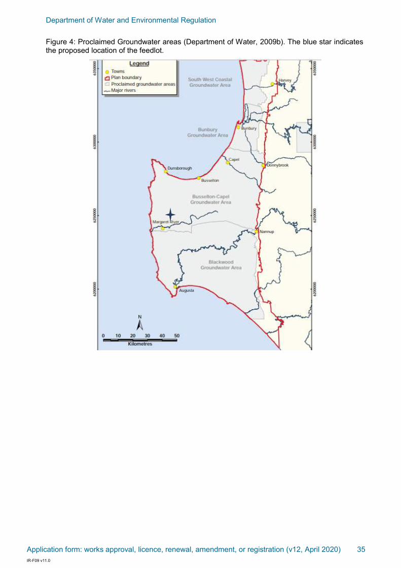
Department of Water and Environmental Regulation
Application form: works approval, licence, renewal, amendment, or registration (v12, April 2020) 35 IR-F09 v11.0
Figure 4: Proclaimed Groundwater areas (Department of Water, 2009b). The blue star indicates the proposed location of the feedlot.

Department of Water and Environmental Regulation
Application form: works approval, licence, renewal, amendment, or registration (v12, April 2020) 36 IR-F09 v11.0
Figure 5: Groundwater subareas for the Superficial and Leederville aquifers (Department of Water, 2009b). The blue star indicates the proposed location of the feedlot.

Department of Water and Environmental Regulation
Application form: works approval, licence, renewal, amendment, or registration (v12, April 2020) 37 IR-F09 v11.0
Figure 6: Groundwater Dependent Ecosystems (Department of Water, 2009b). The blue star indicates the proposed location of the feedlot.
Flora & fauna: The proposed feedlot location does not have any Groundwater Dependent Ecosystems present (Figure 6). There is also no native vegetation within the proposed premise boundary.
Access: Access to the proposed location is via Treeton Road, approximately 3.5 km from the Bussell Highway intersection. Given that there won’t be a net gain in cattle fed at the property (with more finished in the feedlot and less in the paddocks), there isn’t expected to be any impacts on traffic loads or road quality. The entry point to the site has excellent sight distances on a stretch of road that is straight for 1km (approx.). The entry to the site is at the crest of a hill providing improved vision in both directions and for vehicles crossing. Please refer to photographs below showing good vision from the access points.
Sight distances looking west from entry to site

Department of Water and Environmental Regulation
Application form: works approval, licence, renewal, amendment, or registration (v12, April 2020) 38 IR-F09 v11.0
Sight distances to east from entry to site
With respect to vehicle movements the landowner advises that given the through put of cattle will not be changing with respect to the new feed lot from the existing feedlot, traffic generation will be similar. Traffic expected is described as follows:
Bringing in of feed will be 60 tonnes of barley per week – 1 truck per week.
Moving of feed from south to north from the existing shed will be via a new machine which holds 7 tonnes and with typical movement of feed over the week there will be an average of 1 to 3 crossings of the road per day.
With respect to removal of manure, during summer manure dries off quickly and breaks down particularly with the onset of dung beetles. As such, the removal of manure is estimated by the landowner at about 14 cubic metres per week and therefore 1 truck per week to be taken off site which is easy to distribute or sell as it is in high demand.
Stock deliveries will be estimated at approximately at 100 cattle per week which will arrive in lots of around 50 and therefore 2 trucks per week will be delivered and 2 trucks per week (100 cattle) will be taken away.
Other farm vehicles movements will be typical to existing farm activity.
In summary, the movement of vehicles associated with the use is stated to be similar to current activity:
o 1 truck per week for introduction of feed
o 1 to 3 crossings of the road per day moving of feed
o 1 truck per week removal of manure
o 2 trucks per week introduction of stock
o 2 trucks per week removal of stock
o movement of normal farm vehicles
2. SEPARATION DISTANCES
The s-factor calculation (MLA, 2012) can be used to quantify the required separation distance between a feedlot and a sensitive receptor. In this instance, a single rural dwelling and a public use area are nearby to the feedlot, so minimum separation distances for both have been calculated by DPIRD. As follows:
Single rural dwelling – property to the north approximately 490m away from feedlot
D= √N x S
where N = feedlot capacity in SCU = 810 SCU
D = separation distance (m)
S = composite site factor = S1 X S2 X S3 X S4 X S5
S1 = design and management factor = 47 (<750mm rainfall, 17 m2/SCU)
S2 = receptor factor = 0.3 (single farm or rural dwelling)
S3 = terrain factor = 1.2 (katabatic drainage)

Department of Water and Environmental Regulation
Application form: works approval, licence, renewal, amendment, or registration (v12, April 2020) 39 IR-F09 v11.0
S4 = vegetation factor = 1.0 (crops only, no effective tree cover)
S5 = wind direction factor = 1.0 (normal)
S = S1 X S2 X S3 X S4 X S5 = 16.92
D = √810 x 16.92
= 481 m
Therefore the minimum separation distance of the feedlot of 810 SCU is 481m from the nearest single farm or rural dwelling that is 490m to the north.
Single rural dwelling – property to the south approximately 504m away from feedlot
D= √N x S
where N = feedlot capacity in SCU = 810 SCU
D = separation distance (m)
S = composite site factor = S1 X S2 X S3 X S4 X S5
S1 = design and management factor = 47 (<750mm rainfall, 17 m2/SCU)
S2 = receptor factor = 0.3 (single farm or rural dwelling)
S3 = terrain factor = 1.0 (katabatic drainage)
S4 = vegetation factor = 0.85 (a combination of crops and bush)
S5 = wind direction factor = 1.0 (normal)
S = S1 X S2 X S3 X S4 X S5 = 11.985
D = √810 x 11.985
= 341 m
Therefore the minimum separation distance of the feedlot of 810 SCU is 341m from the nearest single farm or rural dwelling that is 504m to the south.
Day use activity – property to the east approximately 645m away from feedlot
D= √N x S
where N = feedlot capacity in SCU = 810 SCU
D = separation distance (m)
S = composite site factor = S1 X S2 X S3 X S4 X S5
S1 = design and management factor = 47 (<750mm rainfall, 17 m2/SCU)
S2 = receptor factor = 0.05 (low use public area)
S3 = terrain factor = 1.2 (katabatic drainage)
S4 = vegetation factor = 1.0 (crops only, no effective tree cover)
S5 = wind direction factor = 1.0
S = S1 X S2 X S3 X S4 X S5 = 2.82
D = √810 x 2.82
= 81 m
Therefore the minimum separation distance of the feedlot of 810 SCU is 81m from the public use area (Tassell Park Wines). The actual distance to the nearest public use area (Tassell Park Wines) is 645m.
Separation Distance Assessments above provided by DPIRD
The residence at Tassell Park Wines is only used intermittently, as required to house seasonal workers. The cellar door facilities at Tassell Park are not operational, with Tassell Park wines now sold from a facility in the township of Cowaramup.
The prevailing winds of the area will assist in shifting any feedlot odours away from the nearby day use sensitive receptors. Tassell Park Wines and the residence located at Tassell Park

Department of Water and Environmental Regulation
Application form: works approval, licence, renewal, amendment, or registration (v12, April 2020) 40 IR-F09 v11.0
Wines are located in an easterly direction from the feedlot, whilst Brookwood Estate is located to the south-east. The prevailing winds for the site are south-south-easterly and southerly.
Additionally, the closest sensitive receptors in the north, north-west and north-east (all more than 490m away from this feedlot) meet the required minimum separation distance of 481m.
3. FEEDLOT DESIGN
Feed manufacturing facility: There will be no feed manufacturing facility at the new feedlot site. There will be a 4 metre wide feed lane running on the outside of both rows of pens to distribute feed into feed bunks. The feed lane at the silt trap will divert around the bottom of the pond and recommence at the silt trap at the other side of the feedlot facility (refer to Attachment 7). There will be a collection drain on the eastern end of the silt trap that will divert water from each of the feed lanes into the silt trap. Any rainfall that falls on the feed lane as it diverts around the bottom of the pond will be fresh water and drain into the natural environment.
An existing feed preparation area exists on the southern side of Treeton Road, alongside the existing feedlot. The feed produced within this facility is used onsite only. There are no plans to commercialise by selling manufactured feed offsite. The feed manufacturing facility only operates from late October (in preparation for feeding to commence in November) to May.
The maximum production from the feed manufacturing area is 1800 tonnes per year. This is based on the weight of the feedstuffs, so there will be some variation around this figure. The shed that houses the feed manufacturing equipment is closed on 3 sides and open on the fourth side.
A 24 inch roller mill is used onsite, which has a design capacity of 10 tonne/hour for barley and 5 tonne/hour for lupins. Fully enclosed grain augers are used to deliver the feed to the manufacturing facility. All augers used onsite are enclosed.
Feed consumption per animal whilst in the feedlot (notionally 60-70 days) is 600-700kg. This can vary depending on the dry matter content of the feed.
The supporting information for the feed manufacturing facility that was submitted as part of the previous works approval application is relevant and applicable to this updated works approval application.
Washdown of equipment and vehicles: There will be no washdown of equipment or machinery at the feed manufacturing facility or the feedlot facility.
Storage of fuels and chemicals: There are no fuels or chemicals stored at the feed manufacturing facility or the feedlot facility.
Cattle yards: A new set of cattle yards are to be constructed within close proximity of the feedlot. The footprint of these yards will be approximately 97 x 30m. A raceway will run between the two rows of pens, allowing for unobstructed movement of cattle between the yards and pens.
Within the yards area as indicated on the application plans there will be a central covered work area of approximately 10 x 15 metres at approximately 3 metres high. This will effectively be constructed as an open sided pergola area to provide cover for workers in the yards and to protect from the elements whether that be the sun or rain. This is indicated on the plans and will be a simple structure with posts and colour bond/zincalume roof.
Pen design: Stocking density within the pens will be 14 m2 per head (or 17 m2 per SCU). There are to be two rows of 4 pens. These eight pens will each have the dimensions of 39 x 45m, totally 1755 m2 which allows for a carrying capacity of 125 head/pen.
Feed bunks will be located along the fence line (upper slope) of each pen. Water troughs will be located along the internal fence line of each pen, approximately half way up the length of the pens.
For the sake of protecting the quality of the feed, covers made from corrugated iron will be

Department of Water and Environmental Regulation
Application form: works approval, licence, renewal, amendment, or registration (v12, April 2020) 41 IR-F09 v11.0
constructed over the feed bunks. These roofs will be 2m wide, totalling an area of 2 x 39m per pen. Rainfall from these roofs will be intercepted using gutters and piped away from the controlled drainage area and into the natural environment.
Infrastructure construction: The method provided in Appendix C (Clay lining of feedlot pens, pads and drainage system) of the National Guidelines will be used to ensure a permeability of at least 1x10⁻⁹ m/s is achieved within the pens, yards, feed lane, drains, silt trap and evaporation pond. Clay will be imported to achieve this permeability, with the suitability of the clays to be tested prior to transportation to the feedlot site. Two separate layers of 150mm of the clay soil will be formed and compacted to achieve a minimum depth of 300mm (after compaction).
The clay soils that are to be imported to form the impermeable pad under the feedlot infrastructure were tested by Construction Sciences on the 13 December 2019. All three samples were collected in the vicinity of the existing dam located approximately 220m NE of the proposed feedlot site. This is the dam that is shown as being 470m from the existing burial pit in the Section 10: Maps. The results of the 3 permeability tests are:
Sample 1: 4x10⁻⁹ m/s
Sample 2: 7x10⁻⁹ m/s
Sample 3: 6x10⁻⁹ m/s
A further backup supply of clay is also available onsite and this has likewise been tested and reported by Sean Smith (refer to attached report for details). This shows there is adequate volume and type of clay to construct and maintain the feedlot.
Drainage system:
The breakdown of the controlled drainage area of the feedlot facility is shown in Table 2.
Table 2: The dimensions of the key feedlot infrastructure, showing total area and total area contributing to the pond (total area minus the covered area).
Dimensions Area Area covered AREA contributing to pond
Pens (45 x 39m) x 8 14,040m2 (2 x 39m) x 8 = 624m2 13,416m2
Yards 30 x 97m 2,910m2 15 x 10m = 150m2 2,760m2
Feed lane (186 x 4m) x 2 1,488m2 Nil 1,488m2
Raceway/drain 156 x 7m 1,092m2 Nil 1,092m2
Silt trap 97 x 3m 291m2 Nil 291m2
Evaporation pond 97 x 22.15m 2,149m2 Nil 2,149m2
TOTAL 21,970m2 21,196m2
The controlled drainage area will be engineered so that the pens slope towards the central raceway, which will also serve as the main drain. The slope of the pens towards the main drain will be 3%, with an expected pen-to-pen drainage of no more than 2%. The central raceway/main drain will be lined with clay to achieve a permeability of 1x10⁻⁹ m/s. This main

Department of Water and Environmental Regulation
Application form: works approval, licence, renewal, amendment, or registration (v12, April 2020) 42 IR-F09 v11.0
drain will have a slope of 3% and will direct all wastewater to a concrete flume (500mm high, 1200mm long). This will allow water from the main drain to drop 500mm into the silt trap, which will also be clay lined to achieve a permeability of 1x10⁻⁹ m/s. The silt trap will be 500mm below the central drain. The silt trap will run the width of the feedlot, being 97m. The silt trap will be connected to the evaporation pond with four sloping 300mm pipes. These pipes will be 300mm above the base of the silt trap, sloping towards the base of the evaporation pond. Overland flow from the silt trap and pond will be directed over paddocks northward by camber and banks as required. This is to ensure water does not flow southward towards Treeton Road. This is shown on the plans.
De-stocking is to occur by the end of May. Before the end of May, the entire feedlot facility will be scraped clean of manure and any other waste materials. Run-off from the controlled drainage area during the month of June will be directed to the silt trap and evaporation pond. The rainfall received during the month of June will serve to flush any remaining waste products to the silt trap. The silt trap will then be cleaned at the end of June. During the months of July, August, September and October, all runoff from the feedlot is considered to be stormwater (free of nutrients) and will be diverted away from the evaporation pond northwards as explained above.
Once the feedlot is cleaned by the end of May, cattle will not be permitted access to the feedlot during the months of June, July, August, September and October. Likewise, no feedstuff will enter the feedlot and no manure or other waste products will enter or be stored at the feedlot during these months.
Pipes and plugs will be used to divert wastewater to the pond and stormwater to the paddock. During the months of November to June, the winter runoff pipes (one on each side of the silt trap) will be plugged so that all wastewater is directed to the evaporation pond. During the months of July to October, these plugs will be removed and the four wastewater pipes into the evaporation pond will be plugged. All pipes are to be 300mm wide and plugs will be made of fitted industrial polyvinyl chloride (PVC).
From the winter runoff pipes the fresh water will be taken by a grassed waterway to a level spill bank to distribute it evenly across the paddock. The spill bank will be at least 30m in length, 150mm high and run parallel to the contours, allowing for the water to spread evenly into the paddock.
Effluent evaporation pond: The controlled drainage area (totalling 19,047m2 when the diverted rainfall is considered) will terminate in an effluent evaporation pond. The pond base and walls will be lined with imported clay to provide a design permeability of at least 1 x 10⁻⁹ m/s. The surface area of the pond is required to be 2,149m2 (see Section 9: Appendix). This calculation has taken into consideration that the feedlot will only operate during three (May, June, October) of the winter months (May to October). Based on Bureau of Meteorology data, 37% of winter rainfall occurs during May, June and October, so this has been factored into the equation when winter rainfall is considered.
The pond will measure 97 x 22.15m at a depth of 2.1m with base raised up above ground level slightly at the eastern end. This depth includes a freeboard of 2m that will be maintained on the evaporation pond from the groundwater table. If this freeboard is ever compromised, the excess wastewater would be tankered offsite by a licensed waste transporter. This removes the need for a spillway.
Manure production, storage and utilization: Manure is a natural by-product from a cattle feedlot and is a valuable commodity in the farming system. It is estimated that the annual manure production of a 450kg animal is 1.10 tonnes/year of scraped manure (Department of Agriculture and Fisheries Qld). For a feedlot with a 1000 head capacity, this equates to 1100 tonnes of manure for the year. With drying and dung beatle activity the landowner expects a reduction of tonnage. This feedlot will not be operating for 12 months of the year so this figure is estimated to be 642 tonnes over 7 months however, based on the owners calculations that 14cubic metres of cow manure per week will be accumulated, over the 7

Department of Water and Environmental Regulation
Application form: works approval, licence, renewal, amendment, or registration (v12, April 2020) 43 IR-F09 v11.0
months season that is 392 cubic metres. This would therefore be a reduction from the 1.1 tonnes per animal calculated to 642 tonnes. If actual cow manure weight is larger than 14cubic metres per week, (due to drying and Dung Beetle activity not being so prolific), it will simply require slightly more regular removal. The volume of manure is estimated by the farmer at 14cubic metres per week based on experience.
Pens are to be cleaned approximately every 8 to 10 weeks as cattle exit the feedlot. Pen cleaning and under fence cleaning will be conducted using a three point linkage grader blade on the back of a tractor, with all care taken to protect the integrity of the pen surface. Because the pen surface is to be engineered when the clays are imported to the site, the pen surface will be flat which will minimise the chances of damaging the clay liner when pens are cleaned. Manure is scraped into windrows and removed with a loader. No water will be used for pen cleaning. All manure is to be transported off-site immediately after pen cleaning (within 12 hours). No manure is to be stockpiled within the controlled drainage area or on the property, and no manure is to be spread on the property.
Deceased animals: Dead animals will continue to be treated in the same manner as at present. Cattle in pens are checked daily, with deceased animals being transported to an onsite, existing burial pit once discovered (i.e. – daily). The burial pit is approximately 2m deep, lined with clay and located 20m W of the proposed feedlot site. Deceased animals will be immediately covered upon entry into the burial pit using at least 150mm of clay (no lime is added). Deceased animals will not be stockpiled within the feedlot. Currently approximately 6-8 animals are buried in the burial pit per year, with this number expected to increase to 10 animals per year in the proposed feedlot.
4. MAINTENANCE & RECORDING
A maintenance program will be implemented to maintain the effective working condition of all components of the feedlot. This will include:
Feedlot pens are scraped clean every 8 to 10 weeks as cattle are removed for sale, or as required. No water is used in the cleaning of feedlot pens.
Drains and the silt trap will be regularly cleaned to ensure manure build up doesn’t impede efficient drainage. The drains and silt trap will be cleaned using a front end loader.
The pond will be cleaned when the sludge reaches a depth of 50mm. The pond will be cleaned using a front end loader.
In the case that the 1.5m freeboard is compromised, excess liquid waste will be transported offsite by a licensed waste contractor. Freeboard markers will be installed in the pond to assist with the monitoring of water levels.
All manure and sludge removed from the pens, drain, silt trap and pond will be taken off-site (within 12 hours) after cleaning takes place.
A visual check of the pen surface, yards, drains, silt trap and evaporation pond will be made weekly. Repairs to this infrastructure will be made as required. Any repairs to the feedlot infrastructure will be detailed in an excel spreadsheet and dated.
Any odour complaints received will be correlated with weather conditions and the operations at the feedlot at the time. All of this information (details of the odour complaint, weather conditions, current operations) will be recorded in an excel spreadsheet and dated.
The applicant is planning on obtaining accreditation under the National Feedlot Accreditation Scheme should this works approval be approved and once the feedlot is operational.

Department of Water and Environmental Regulation
Application form: works approval, licence, renewal, amendment, or registration (v12, April 2020) 44 IR-F09 v11.0
5. RISK ASSESSMENT OF DISCHARGES & EMISSIONS
The following risk assessments have been conducted in line with the Guidance Statement: Risk Assessments (Department of Environment Regulations, February 2017) and as per the information provided in Table 3.
Table 3: Risk rating matrix (Department of Environment Regulations, February 2017).
Protection of groundwater: Any intensification of animals can result in groundwater contamination if the design and subsequent operation of a facility is below industry standards. A significant investment will be made in ensuring that feedlot infrastructure will be underlain with an impermeable layer that achieves at least the required 1x10⁻⁹ m/s permeability. All contaminated and potentially contaminated wastewater will be directed to an appropriately sized evaporation pond that will maintain a freeboard of 1.5 metres so the risk of contaminants exiting the feedlot and entering the groundwater is negligible. Furthermore the feedlot will be non-operational in the winter months when the groundwater is closest to the surface.
Risk: contamination of groundwater as a result of infiltration of contaminated stormwater or leachate emissions.
Likelihood: Possible
Consequence: Slight
RISK RATING: Low
Protection of surface water: The proposed feedlot facility is designed to be a closed loop system with the slope of the hardstand and the presence of catch drains to direct all wastewaters to the silt trap and evaporation pond. All contaminated stormwater and leachate emissions will be directed to the evaporation pond. If the freeboard on the evaporation pond is compromised, liquid waste will be transported offsite by a licensed waste contractor. The operations at the site, given the facility design, should not impact the Carbunup River.
Risk: contamination of surface water as a result of run-off of contaminated stormwater or leachate emissions.
Likelihood: Unlikely
Consequence: Slight
RISK RATING: Low
Department of Water and Environmental Regulation
Application form: works approval, licence, renewal, amendment, or registration (v12, April 2020) 45 IR-F09 v11.0
Dust: Although the s-factor equation doesn’t explicitly consider dust emissions, it is assumed that achieving the required separation distance in terms of odour will likely be enough to provide adequate protection from dust. Given the relatively high rainfall location and the fact that the feedlot will operate with a relatively high stocking density over, it is unlikely that dust will be a nuisance. Use of clay soil base will also minimise dust.
Risk: dust emissions from the facility impacting the amenity of nearby sensitive receptors.
Likelihood: Possible
Consequence: Low
RISK RATING: Low
Noise: The feedlot facility will be managed so as to minimise offsite noise impacts. In most instances, the only audible noise that will come from the facility is machinery and cattle noise. The feedlot will only operate between 6am and 6pm to reduce the chance of machinery noise impacting on neighbours.
Risk: noise emissions from the facility impacting the amenity of nearby sensitive receptors.
Likelihood: Possible
Consequence: Slight
RISK RATING: Low
Odour: The construction of a fit-for-purpose feedlot facility in accordance with the National Guidelines is the best protection that can be afforded. The following evidence is supplied to provide some confidence that odour from the proposed feedlot shouldn’t impact the amenity of nearby sensitive receptors:
The required separation distance to nearest sensitive receptors is achieved as per the s-factor equation in the National Guidelines.
Pens will be cleaned more regularly than the industry standard (13 weeks in the National Guidelines).
All manure and waste products are to be taken off-site within 24 hours of the facility being cleaned. No manure will be stockpiled or spread within the feedlot or the property at 355 Treeton Road, Cowaramup.
The engineered slope of the hardstand will help to prevent the pooling of stagnate wastewater.
The direction of the prevailing winds will influence the presence of odour at nearby day use sensitive receptors. The prevailing wind at 9am is a south-easterly, which will push the odour away from the closest public use area.
Risk: odour emissions from the facility impacting the amenity of nearby sensitive receptors.
Likelihood: Possible
Consequence: Low
RISK RATING: Low

Department of Water and Environmental Regulation
Application form: works approval, licence, renewal, amendment, or registration (v12, April 2020) 46 IR-F09 v11.0
6. DECOMMISSIONING OF EXISTING FEEDLOT
The existing feedlot on the southern side of Treeton Road will be decommissioned, with feed bunks and feedlot fencing removed and the area will be returned to cropping land. This will occur once construction of the new feedlot (north of Treeton Road and as detailed in this application) commences, and prior to accepting stock in the new feedlot. At no times will both feedlots operate at the same time.
7. COST OF WORKS
1. $50,000 – Earthworks by Vasse Transport and Earthmoving (hire of bulldozer, dump trucks, excavator and grader, labour).
2. $15,000 – Electricity connection.
3. $2,000 – Permeability testing of soils.
8. REFERENCES
Department of Primary Industries and Fisheries Qld, Feedlot Waste Management Series: Manure Production Data.
Department of Environment Regulation (February 2017), Guidance Statement: Risk Assessments.
Department of Water (2009a), Whicher Area surface water allocation plan, Water Resource Allocation and Planning Series, Report No 19.
Department of Water (2009b), SouthWest Groundwater Areas Allocation Plan, Water Resource Allocation and Planning Series, Report No 21.
MLA (2012), National Beef Cattle Feedlot Environmental Code of Practice, 2nd edition.
MLA (2012), National Guidelines for Beef Cattle Feedlots in Australia, 3rd edition.
Department of Water and Environmental Regulation
Application form: works approval, licence, renewal, amendment, or registration (v12, April 2020) 47 IR-F09 v11.0
9. APPENDIX
a. Catchment size (CS) (m²) 19,047m2 (this is the area of the feedlot minus the covered areas and minus the pond area)
b. Winter evaporation (WE) (m) 312mm
c. Run off co-efficient (RC) 25%
d. 1:20 winter rainfall (WR) (m) 1121mm
e. Average Annual Rainfall (mm) 957mm
f. Total annual evaporation (TE) (m) 1021mm
Calculating Run In (RI)
Run in = CS x WR x RC (m³)
= 19047 x 1.121(0.37) x 0.25
= 1975m³ (1.975ML)
Calculating insitu contribution (IC)
= WR – WE (m)
= 1.121(0.37) – 0.312
= 0.102
Calculating minimum surface area (m²)
= RI / (TE-IC)
= 1975 / (1.021-0.102)
= 2149 m²

Department of Water and Environmental Regulation
Application form: works approval, licence, renewal, amendment, or registration (v12, April 2020) 48 IR-F09 v11.0
10. MAPS
Map 1: Location of the feedlot in relation to the property boundary.


Department of Water and Environmental Regulation
Application form: works approval, licence, renewal, amendment, or registration (v12, April 2020) 50 IR-F09 v11.0
Map 3: Distance to the nearest sensitive receptors
Map 4 location

Department of Water and Environmental Regulation
Application form: works approval, licence, renewal, amendment, or registration (v12, April 2020) 51 IR-F09 v11.0
Map 4: The location of the permeability tests, taken from around the dam that is located approximately 230 NE of the proposed
feedlot site.

S J SMITH AND ASSOCIATES 27 Charles Hine Avenue
Environmental and Landscape Management
Margaret River WA 6285
Environmental Management Plans Wastewater /
soil assessment Bushland and Foreshore assessment /
plans Flora assessments Weed and pest
management plans Rehabilitation / Landscaping
plans Rehabilitation planting
Ph. 9758 7926
M. 0437 806 119
Email: [email protected]
ABN 59 590 150 452
20 April 2020
Mr Marc Halsall
Halsall and Associates
PO Box 29
Margaret River WA 6285
Dear Marc
RE: LOT 100 NO. 355 TREETON ROAD, COWARAMUP – SOIL ASSESSMENT FOR PLANNED SUMMER INTENSIVE FEED LOT
The proposed summer feed lot/intensive feeding paddock is located approximately central to Lot 100 No. 355 Treeton Road, Cowaramup.
The site is just over 3 kilometres from the Cowaramup town centre and is surrounded by other Priority Agriculture lots primarily used for grazing and several small vineyards. There are several nearby conservation lots.
The site was visited on 2 April 2020 to determine summer/autumn depth to watertable at the proposed location of the run-off retention dam. Samples were taken to determine soil texture for the soil horizons at this location. Three samples were taken from an additional clay pit site for analysis by the Construction Sciences laboratory in Bunbury to determine constant head permeability. The purpose of this report is to provide the results of the soil testing and a brief interpretation of the results.

Figure 1: Site location and context (source: Shire of Augusta-Margaret River Intramaps)
Figure 2: Town Planning Scheme zoning – Priority Agriculture (source: Shire of Augusta-Margaret River Intramaps)
The property is not within a Priority Drinking Water Source area. No Environmentally Sensitive Areas are shown on or near the area affected by the proposal.

Sampling has previously been undertaken from another clay pit site on the property to determine the suitability of native clay for lining the paddocks and run-off retention dam. The clay was tested by Construction Sciences on the 13 December 2019. All three samples were collected in the vicinity of the existing dam located approximately 230m WSW of the proposed feedlot site.
The results of these previous 3 permeability tests are:
• Sample 1: 4x10⁻⁹ m/s
• Sample 2: 7x10⁻⁹ m/s
• Sample 3: 6x10⁻⁹ m/s”
All three samples were suitable according to the method provided in Appendix C (Clay lining of feedlot pens, pads and drainage system) of the National Guidelines. The National Guidelines stipulate that clay used within the pens, yards, feed lane, drains, silt trap and evaporation pond will have a permeability of at least 1x10⁻⁹ m/s (see Appendix 1 of this report). Two separate layers of 150mm of the clay soil will be formed and compacted to achieve a minimum depth of 300mm (after compaction).
In order to address concerns that there may not be adequate clay available from the initial test site, additional testing has been undertaken. The soil testing was undertaken at the Construction Sciences Laboratory in Bunbury on 16 April 2020. All of the waypoints recorded on the site are shown in Figure 3 below.
Figure 3: Waypoints for the proposed run-off retention dam (WP162) and additional clay suitability
testing (WP163-165)

Table 1: Laboratory results for soil permeability
Sample identification Waypoint Permeability (m/s)
1 163 9 x 10⁻¹⁰
2 164 5 x 10⁻⁹
3 165 8 x 10⁻⁹
All of the results are within the requirements outlined in the National Guidelines and also the State Government’s Water Quality Protection Note (No. 27) Liners for containing pollutants, using engineered soils.
Figure 4: Pit to determine groundwater depth.

In order to determine the depth to groundwater, a pit was excavated to a depth of slightly less than 5 metres. No groundwater was found at this depth during the site visit on 2 April.
The testing was undertaken in early autumn after the break of the season and considerable recent rainfall; however it does not represent the winter groundwater maximum. Ongoing monitoring and additional drainage management will be required to manage heavy rainfall events.
Figure 5: Contours across site (source: Department of Agriculture)

Given the relatively high contour of the site, it is likely that groundwater is well below the ground surface throughout the year.
The soil horizons of the test pit (WP162) were recorded at the site and are as follows:
Table 2: Soil texture for test pit
Horizon Depth Description Texture Texture according to USDA texture triangle
1 0-20 Dark grey organic matter
5% organic matter, 10% light coloured clay/silt, 85% grey sand
Loamy sand
2 20-80 Grey gravel 25% light coloured clay, 25% silt, 50% grey/brown sand
Loam
3 80-180 White, red and yellow clay/gravel
40% light clay, 20% silt, 40% sand
Clay
4 180-475 White and yellow clay and grit
30% clay, 20% silt, 50% sand
Clay loam
The soil texture analysis identifies the presence of clay at depth. According to Wells (2001) the two deeper horizons are likely to have hydraulic conductivities to between 6 x 10⁻⁸ and 1 x 10⁻⁹ indicating that the in-situ clays may provide the necessary permeability in addition to the clay sources on site that will be used to construct the pens, infiltration pond etc.
Figure 6: Hydraulic conductivity, soil texture and wastewater disposal class according to Wells (2001).

Figure 7: Soil types across the site (source: Department of Agriculture)
The soils across the central portion of the overall site are classified as the Treeton Hillslopes (TRh) phase (see Figure 7 above). These soils occur on gentle hillslopes on colluvium and weathered mantle over sedimentary rocks. The soils are generally duplex sandy gravels, loamy gravels, grey deep sandy duplex soils, pale sandy earths and semi-wet soils (Department of Agriculture, 2020). Vegetation includes marri-jarrah forest and woodland. The Treeton Hillslopes phase is generally described as hillslopes with gradients generally ranging from 2-15% and gravelly duplex (Forest Grove) and pale grey mottled (Mungite) soils. The degradation risks for the site are generally considered to be minimal, with only 7% of the soil classification having a high risk of water erosion.
The soils on the western portion of the lot are classified as the Wilyabrup undifferentiated hillslopes phase (WLh) (Department of Agriculture, 2020). These soils occur on gentle to moderate valley slopes on colluvium and weathered mantle over granite. Soils consist of loamy gravels, duplex sandy gravels, brown deep loamy duplexes and friable red/brown and brown loamy earths. Typical vegetation includes marri-jarrah forest and woodland. Around 5 per cent of the soils in this classification have a very high risk of water erosion. Five per cent of the soils within this classification have a very high risk of phosphorous loss.
The soils on the southern portion of the lot adjacent Treeton Road are classified as the Treeton wet slope phase (TRw2) phase (Department of Agriculture, 2020). These soils occur on gentle slopes with high winter water tables and pale grey mottled (mungite) soils. The soils are generally semi-wet soil/grey deep sandy duplex and semi-wet soil/pale loamy earths. Typical vegetation includes marri-jarrah forest and woodland. The main limitation of

these soils is in terms of low microbial purification ability for on-site domestic wastewater disposal due to low permeability.
The Department of Agriculture provides a relative rating of land capability and some limitation is noted for the soils in the proposed feeding paddock. It should be noted that the limitation applies to issues arising from the heavy soil texture and slope. The feeding paddock/feedlot will be constructed to minimise soil infiltration and the heavy soil texture will assist with managing flows of any nutrient rich water.
Figure 8: Relative phosphorous export hazard for the site (source: Department of Agriculture)
Conclusion
The clay resources that are available on the site have been tested and found to be suitable to meet the requirements outlined by both the Federal and State Government guidelines relevant to feed lot construction.
The summer depth to groundwater, representing the peak of use for the feed lot, was found to exceed the requirements set out by the Department of Water for a free-board of 1.8m below the base of the proposed run-off retention pond.
The soils at the base of the proposed retention pond have heavier texture and will provide additional impedance to leakage below the pond.

References
Australian/New Zealand Standard AS1547:2012, On-site domestic wastewater management.
Bureau of Meteorology (2020), Climate Averages for specific sites. Publicly available data prepared by the Bureau of Meteorology, Commonwealth of Australia. http://www.bom.gov.au/climate/averages/tables/ca_wa_names.shtml
Department of Agriculture (2003), Land Profiler, Shires of Capel, Busselton and Augusta-Margaret River, Perth, Western Australia.
Department of Agriculture and Food (2020), Natural Resources, http://www.agric.wa.gov.au/
Department of Environmental Protection (DEP) (2002), West Australian Guidelines for the Direct Land Application of Biosolids and Biosolids Products. Perth, Western Australia.
Department of Health (2001), Code of Practice for the Design, Manufacture, Installation and Operation of Aerobic Treatment Units (ATU’s). November 2001. Department of Health, Perth.
Department of Health (2002), Movement of Nutrients from Onsite Wastewater Systems in Soils. Department of Health, Perth, Western Australia.
Department of Water (2005), Margaret River Catchment Area (Including Ten Mile Brook Catchment) Drinking Water Source Protection Plan.
Department of Water (2006b), WQPN 22, Water Quality Protection Note: Irrigation with Nutrient Rich Wastewater (July 2006). Department of Water, Perth, Western Australia.
Department of Water (2013), WQPN 27, Water Quality Protection Note: Liners for containing pollutants, using engineered soils. Department of Water, Perth, Western Australia.
Department of Water (2006d), WQPN 79, Water Quality Protection Note: Rural restaurants, cafes and taverns near sensitive water resources (May 2006). Department of Water, Perth, Western Australia.
Department of Water (2006e), WQPN 6, Water Quality Protection Note: Vegetation buffers to sensitive water resources (February 2006). Department of Water, Perth, Western Australia.
Department of Water (2009), WQPN 93, Water Quality Protection Note: Light industry near sensitive waters (September 2009). Department of Water, Perth, Western Australia.
Department of Water (2010), WQPN 70, Water Quality Protection Note: Wastewater Treatment and Disposal – domestic systems (June 2010). Department of Water, Perth, Western Australia.
Department of Water (2016), WQPN 25 Land use compatibility tables for public drinking water source areas.
Departments of Health, Planning and Water (2019), Government Sewerage Policy (September 2019)
Government of Western Australia (2005), Health (Treatment of Sewerage and Disposal of Effluent and Liquid Waste) Regulations 1974. October 2005.
Meat and Livestock Australia (2013), National Guildelines for Beef Cattle Feedlots in Australia.
Pen, L.J. (1997), A Systematic Overview of Environmental Values on the Wetlands, Rivers and Estuaries of the Busselton-Walpole Region, Water and Rivers Commission Report WRAP 7.
Tille, P. J. and Lantzke, N. C. (1990) Busselton – Margaret River – Augusta: Land Capability Study. Land Resources Series No. 5. Western Australian Department of Agriculture.
Tille, P. J. and Lantzke, N. C. (1990) Busselton – Margaret River – Augusta: Land

Capability Study. Land Resources Series No. 5. Western Australian Department of Agriculture.
Wells, M. (2001), Assessment of Land Capability for On-Site Septic Tank Effluent Disposal. Agriculture WA, Perth, Western Australia.

APPENDIX 1: APPENDIX C OF NATIONAL GUIDELINES FOR BEEF
CATTLE FEEDLOTS IN AUSTRALIA


![COMPANY PROFILE-SARA TEX SOURCING BDsaratexsourcing.com/Sara Profile.pdf · 6lqfh 6$5$ 7(; 6285&,1* %$1*/$'(6+ 75867(' 5($'< 0$'( *$50(17 (;3257,1* $1' 6285&,1* $*(17 k µ } o ] Ç](https://img.pdfslide.us/doc/110x75/5f850373d1359501d6699ee0/company-profile-sara-tex-sourcing-profilepdf-6lqfh-65-7-62851-16.jpg)