Embed Size (px)
Citation preview

NI 43-101 Technical Report San Carlos Property, Río Viejo, Norosí, and San Martín de Loba Municipalities, Bolivar, Colombia
Report Prepared for
8768820 Canada Inc.
118-750 boul. Marcel-Laurin
Montréal QC H4M 2M4 Canada
Effective Date: June 30th , 2015 Report Date: June 30th, 2015
Signed by QP: Giovanny Ortiz, FAusIMM
Report Prepared by
Energy OMR S.A.S.
Carrera 8 # 10-78 Local 2 Floridablanca, Santander, Colombia

Energy OMR SAS NI 43-101 Technical Report – San Carlos Property i
June 30, 2015
Table of Contents
List of Tables ..................................................................................................................... 3
List of Figures .................................................................................................................... 4
Appendices ........................................................................................................................ 6
1 Summary (Item 1) ......................................................................................................... 1
Property Description and Location ............................................................................................................... 1
Mineral Tenure ............................................................................................................................................. 1
Geology and Mineralization ......................................................................................................................... 1
Exploration ................................................................................................................................................... 3
Conclusions and Recommendations ........................................................................................................... 4
2 Introduction (Item 2) .................................................................................................... 5
2.1 Purpose of the Report and Terms of Reference................................................................................. 5
2.1.1 Units of Measure ..................................................................................................................... 5
2.1.2 Abbreviations .......................................................................................................................... 5
2.1.3 Common Units ........................................................................................................................ 6
2.1.4 Common Chemical Symbols ................................................................................................... 6
2.1.5 Common Acronyms ................................................................................................................ 6
2.2 Qualifications of the Consultant .......................................................................................................... 7
2.3 Personal Inspection of the Property ................................................................................................... 7
3 Reliance on Other Experts (Item 3) ............................................................................ 8
4 Property Description and Location (Item 4) ............................................................... 9
4.1 Property Description and Location ..................................................................................................... 9
4.2 Mineral Tenure .................................................................................................................................. 11
4.2.1 Mining Concession Contract No. 12033 ............................................................................... 13
4.2.2 Mining Concession Contract No. 14305 ............................................................................... 14
4.2.3 Mining Concession Contract No. JGF-09412 ....................................................................... 14
4.3 Rights and Obligations of the Mining Concession Contract ............................................................. 14
4.4 Environmental Liabilities and Permitting ........................................................................................... 17
4.4.1 Environmental Liabilities ....................................................................................................... 17
5 Accessibility, Climate, Local Resources, Infrastructure and Physiography (Item 5) ........................................................................................................................ 18
5.1.1 Accessibility ........................................................................................................................... 18
5.1.2 Local Resources and Infrastructure ...................................................................................... 19
5.1.3 Climate .................................................................................................................................. 19

Energy OMR SAS NI 43-101 Technical Report – San Carlos Property ii
June 30, 2015
5.1.4 Physiography and Vegetation ............................................................................................... 19
6 History (Item 6) ........................................................................................................... 21
6.1 Prior Ownership of the Property ....................................................................................................... 21
6.1.1 Mining Concession Contract No. 12033 ............................................................................... 21
6.1.2 Mining Concession Contract No. 14305 ............................................................................... 21
6.1.3 Mining Concession Contract No. JGF-09412 ....................................................................... 21
6.2 Previous Exploration Activities ......................................................................................................... 22
6.2.1 Exploration Works of Sociedad Kedahda SA – B2Gold Corporation (Joint Venture), 2007 ...................................................................................................................... 22
6.2.2 Exploration Works of Orofino Gold Corporation, 2011 ......................................................... 30
6.3 Historical Production ......................................................................................................................... 30
6.4 Historical Mineral Resource Estimates ............................................................................................. 31
7 Geological Setting and Mineralization (Item 7) ........................................................ 32
7.1 Regional Geology ............................................................................................................................. 32
7.1.1 Structural Geology ................................................................................................................ 34
7.2 Property Geology .............................................................................................................................. 36
7.2.1 Lithology ................................................................................................................................ 36
7.2.2 Structural Geology ................................................................................................................ 43
7.2.3 Mineralization ........................................................................................................................ 44
8 Deposit Type (Item 8) ................................................................................................. 58
8.1 Porphyry type deposit ....................................................................................................................... 58
8.2 Reduced Intrusion-related gold deposit ............................................................................................ 60
9 Exploration (Item 9) ................................................................................................... 63
9.1 Topographic Surveys ........................................................................................................................ 63
9.2 Geochemical Sampling ..................................................................................................................... 63
9.2.1 Soil Sampling ........................................................................................................................ 63
9.2.2 Stream Sampling................................................................................................................... 65
9.2.3 Rock Sampling ...................................................................................................................... 66
10 Drilling (Item 10) ......................................................................................................... 73
10.1 Drilling results ................................................................................................................................... 75
11 Sample Preparation, Analysis and Security (Item 11) ............................................ 78
12 Data Verification (Item 12) ......................................................................................... 79
12.1 Procedures........................................................................................................................................ 79
13 Mineral Processing and Metallurgical Testing ........................................................ 81
14 Mineral Resource Estimate (Item 14)........................................................................ 82

Energy OMR SAS NI 43-101 Technical Report – San Carlos Property iii
June 30, 2015
15 Mineral Reserve Estimates (Item 15) ........................................................................ 83
16 Mining Methods (Item 16) .......................................................................................... 84
17 Recovery Methods (Item 17) ..................................................................................... 85
18 Project Infrastructure (Item 18) ................................................................................. 86
19 Market Studies and Contracts (Item 19) ................................................................... 87
20 Environmental Studies, Permitting and Social or Community Impact (Item 20) ................................................................................................................................ 88
20.1 Not authorized mining ....................................................................................................................... 88
21 Capital and Operating Costs (Item 21) ..................................................................... 91
22 Economic Analysis (Item 22) .................................................................................... 92
23 Adjacent Properties (Item 23) ................................................................................... 93
24 Other Relevant Data and Information (Item 24) ....................................................... 95
25 Interpretation and Conclusions (Item 25) ................................................................ 96
26 Recommendations (Item 26) ..................................................................................... 98
26.1 Recommended work program .......................................................................................................... 98
26.1.1 Phase I. Detailed geological mapping and regional exploration .......................................... 98
26.1.2 Phase II. First-round drilling ................................................................................................. 99
26.2 Costs ............................................................................................................................................ 100
27 References (Item 27) ................................................................................................ 101
List of Tables
Table 4.1 Status of the Mining Concession Contracts Comprising the San Carlos Property .......................... 11
Table 6.1 Geochemical Samples collected by the Joint Venture ..................................................................... 25
Table 6.2 Summary of Drill Holes completed by the Joint Venture at San Carlos Hill ..................................... 28
Table 6.3 Drilling Results of the Joint Venture Campaign, 2007 ..................................................................... 30
Table 9.1 Summary of Geochemical Sampling on the Property ...................................................................... 63
Table 10.1 Exploration Drill Summary .............................................................................................................. 73
Table 12.1 List of independent samples and results – San Carlos project site visit, April 2015 ...................... 80
Table 26.1 Budget for Recommended Exploration Work on San Carlos Property ........................................ 100

Energy OMR SAS NI 43-101 Technical Report – San Carlos Property iv
June 30, 2015
List of Figures
Figure 4.1 Location of San Carlos Property. .................................................................................................... 10
Figure 4.2 Mining Concession Contracts Comprising the San Carlos Property. ............................................. 12
Figure 4.3 Location of the concessions of the Property respect the Forest Reserve (In Red Dash) (Law No. 2, 1959) ................................................................................................................................ 13
Figure 5.1 Google Earth Image Showing the Buena Seña town, San Carlos and Culo Alzao Hills. Image Looking to NNE. ....................................................................................................................... 18
Figure 6.1 Magnetic Anomalies of San Carlos Hill – Buena Seña – Culo Alzao. ............................................ 23
Figure 6.2 Soil Sampling Results of the Joint Venture Exploration Campaign ................................................ 26
Figure 6.3 Rock Sampling Results of the Joint Venture Exploration Campaign. ............................................. 27
Figure 6.4 Location of Drill Holes completed by the Joint Venture at San Carlos Hill. .................................... 29
Figure 7.1 Geology of the Serranía de San Lucas Region. ............................................................................. 33
Figure 7.2 Major Faults of the Serranía de San Lucas Region. ....................................................................... 34
Figure 7.3 Gneiss in Drill Hole SAC13DDH001, 550.50 m. ............................................................................. 36
Figure 7.4 Geology of the Property. ................................................................................................................. 38
Figure 7.5 Andesitic Tuff, Cut by Quartz-Monzonite-Diorite Porphyritic Micro-Dike. Drill Hole SAC13DDH002, 621.10 m. ................................................................................................................. 39
Figure 7.6 Core of Drill Hole SAC13DDH001: A) Quartz-Monzonitic-Dioritic Porphyry with Quartz Phenocrysts. 451.35 m Depth; B) Quartz Dioritic Porphyry with a Gneiss Xenolite, 617 m Depth. .................................................................................................................................................. 40
Figure 7.7 A) Rhyodacitic Porphyry with Quartz Crystals in Drill Hole SAC13DDH002, 686 m depth. B) Granitic Porphyry with UST Texture (unidirectional silicification texture), in Drill Hole SAC13DDH001 416 m Depth.............................................................................................................. 41
Figure 7.8 Hydrothermal Breccia with Crypto - crystalline Quartz in Drill Hole SAC13DDH001, 351 m Depth. .............................................................................................................................................. 42
Figure 7.9 Structural Scheme of the San Lucas Mountain Range ................................................................... 43
Figure 7.10 Geology and Alteration of San Carlos Hill – Buena Seña Area .................................................... 45
Figure 7.11 Schema of Typical Dense Veinlet Stockwork in Au-Rich Porphyry Deposit Showing Sequential Formation of Different Vein-Types. ................................................................................... 46
Figure 7.12 Left: Fine – Grain Sericite Replacing All the Rock, with a Vein Filled up with Larger Crystals of Sericite, San Carlos; Right: Image in Crossed Polars. ..................................................... 47
Figure 7.13 Left: Fine – Fine-Grained Kaolinite Alteration (kao) Enveloped and Crosscut by Late Sericite (ser). San Carlos Hill; Right: Image in Crossed Polars. ......................................................... 47
Figure 7.14 Sericitic Alteration (ser) Crosscut by Associations with Pyrite (opaque) and Chlorite (green). ................................................................................................................................................ 48
Figure 7.15 A) Granitic Porphyry with Strong K feldspar Alteration, A-Type Veins,A-Type Veins and UST (Unidirectional Solidification Texture) Texture, in Drill Hole SAC13DDH001, 416 m depth; B) Granodioritic Porphyry with Moderate K Feldspar Alteration, Secondary Biotite, Quartz – Molybdenum - Pyrite B - Type Veins Cutting Quartz - K Feldspar – Chalcopyrite - Pyrite AB - Type Vein in Drill Hole SAC13DDH001, 451.35 m Depth. ............................................... 49
Energy OMR SAS NI 43-101 Technical Report – San Carlos Property v
June 30, 2015
Figure 7.16 Vein Infilling with Quartz (qtz), K - Feldspar (KF), Chlorite (green) and Molybdenite (mb). San Carlos Hill, Core 1. ............................................................................................................ 49
Figure 7.17 Andesitic Tuff with Potassic – Calcic Alteration. ........................................................................... 50
Figure 7.18 Left: Image in Crossed Polars. Right: Image in Crossed Polars. Note That Amphibole is Found Into the Veinlets Cutting Across Pyrite. Note Higher Interference Colors in Amphibole............................................................................................................................................ 50
Figure 7.19 Andesitic Tuff with K Feldspar – Sodic Alteration Overprinting the Moderate Secondary Biotite Alteration in Drill Hole SAC13DDH001, 294 m Depth. ............................................................. 51
Figure 7.20 Schematic Vertical Section, Drill Hole SAC13DHH001. ............................................................... 52
Figure 7.21 Schematic vertical section, drill hole SAC13DHH002. .................................................................. 53
Figure 7.22 Interpreted Mineralized Structures at San Carlos Hill – Buena Seña. .......................................... 54
Figure 7.23 Interpreted Mineralized Structures at Culo Alzao ......................................................................... 55
Figure 7.24 Mineralization in El Azul. Milky Quartz – Pyrite – Chalcopyrite – Galena - Sphalerite. ............... 56
Figure 7.25 Interpreted Mineralized Structures at El Azul ............................................................................... 57
Figure 7.26 Inclined Access of the Luis Florez Tunnel in El Azul. ................................................................... 57
Figure 8.1 Anatomy of a telescoped porphyry Cu system showing spatial interrelationships of a centrally located porphyry Cu ± Au ± Mo deposit in a multiphase porphyry stock and its intermediate host rock. ........................................................................................................................ 60
Figure 8.2 Schematic paragenesis of evolving types and metal associations in typical cooling reduced intrusive-related gold systems. Time axis may also represent distance from the causative pluton. ................................................................................................................................. 61
Figure 9.1 Soil Anomalies of Gold .................................................................................................................... 64
Figure 9.2 Stream Sampling Results................................................................................................................ 65
Figure 9.3 Correlation Diagram for Rock Samples from San Carlos – Buena Seña – Culo Alzao .................. 66
Figure 9.4 Correlation Diagram for Rock Samples from El Azul. ..................................................................... 67
Figure 9.5 Rock Sampling Results of the Anglo American and Orofino Campaigns ....................................... 68
Figure 9.6 Artisanal Mines Location and Interpreted High Grade Structure (Vein) Trends in the Property ............................................................................................................................................... 69
Figure 9.7 Interpreted Vein Trends and Rock Sampling Results in San Carlos Hill – Buena Seña Area. .................................................................................................................................................... 70
Figure 9.8 Interpreted Veins and Rock Sampling Results in Culo Alzao Area. ............................................... 71
Figure 9.9 Interpreted Veins and Rock Sampling Results in El Azul Area....................................................... 72
Figure 10.1 Collars and Traces of Drill Holes Completed by Anglo American ................................................ 74
Figure 10.2 Strip Log of Geochemical Results of Au, Mo, Au and Ag. Drill Hole SAC13DDH001. ................ 76
Figure 10.3 Strip Log of Geochemical Results of Au, Mo, Au and Ag. Drill Hole SAC13DDH002. ................ 77
Figure 20.1 Artisanal Process Plant in El Azul. ................................................................................................ 89
Figure 20.2 Access Shaft of an Artisanal Mine in El Azul. ............................................................................... 90
Figure 23.1 Location of the Properties Adjacent to San Carlos Property ........................................................ 94

Energy OMR SAS NI 43-101 Technical Report – San Carlos Property vi
June 30, 2015
Appendices
Appendix A: Assay Certificates of Independent Samples
Appendix B: Certificate of Qualified Person

Energy OMR SAS NI 43-101 Technical Report – San Carlos Property 1
June 30, 2015
1 Summary (Item 1) This report was prepared as a National Instrument 43-101 (NI 43-101) Technical Report by
Energy OMR SAS (EOMR) for 8768820 Canada Inc.
Property Description and Location
The San Carlos Property (The Property) consists of three mining concession contracts
identified with the numbers 12033, 14305 and JGF-09412, totaling 3,234.2 hectares that
were granted by the Colombian Ministry of Mines. The concession contracts are located
within the Rio Viejo, Norosí and San Martín de Loba municipalities, Department of Bolivar,
Republic of Colombia; about 430 km North of the Colombian capital Bogota and 200 km
NW of Bucaramanga, capital of the Department of Santander.
The Property is located overlooking the Magdalena River valley, along the eastern margin
at the foot hill of the San Lucas Mountain Range (Serranía de San Lucas), the northern
portion of the Central Andes of Colombia. The elevation at The Property area ranges from
60 to 350 meters above sea level.
Mineral Tenure
On December 19th
2014, 8768820 Canada Inc. of Canada signed a sale-purchase contract
to acquire 100% of the Colombian company Los Mates SAS. The three concessions are
valid under regulations of the Colombian mining code Law 685 of 2001.
Los Mates owns 100% of the concessions 14305, 12033 and JGF-09412. However, as of
June 30th 2015, 20% of the rights over the concession JGF-09412 were purchased by Los
Mates from Jose Luis Avella Santos, and the transfer process is in course of approval and
registration in the Agencia Nacional de Minería.
The exploitation phase approval for the concession contracts 12033 and 14305 was issued
by the Agencia Nacional de Minería on December 2nd
2010 and April 15th 2011
respectively. The concession contract JGF-09412 entered in the construction and
assemblage phase since February 24th 2014. However, for purposes of the NI 43-101
Technical Report, further exploration work is required before a compliant resource estimate
can be made. The Property is not affected by environmental restrictions related to natural
parks or protected areas.
Geology and Mineralization
The Property is located in the San Lucas Mountain Range that is situated to the NE of the
main mountain range of the Colombian Central Andes. This mountain range contains a
heterogeneous lithological composition with a historical evolution since the Mesoproterozoic
to the Holocene with a generation of metamorphic, igneous and sedimentary rocks
including mineralization.

Energy OMR SAS NI 43-101 Technical Report – San Carlos Property 2
June 30, 2015
The rocks of the basement are the medium-high grade metamorphic rocks of the gneiss of
San Lucas, composed by banded quartz-feldspar gneisses with bands of biotite and
hornblende. Rift-related sedimentary sequences deposition caused by the extensional
tectonics is accompanied by incipient subaerial dacite-andesite explosive volcanism during
late Paleozoic to early Jurassic. The deposition of early middle Jurassic volcanoclastic
sequences of the Norean formation in the region is associated to the Jurassic magmatic
belt development through the Colombian Andes. The pre-existing volcanoclastic and other
rocks are intruded by the early Jurassic formation Norosí-San Martín Batholith. Middle to
late Jurassic magmatism is represented by the intrusion of minor hypabyssal intrusives
affecting mainly the volcanoclastic sequence.
Structurally, the area of the Property is part of the Eastern Zone of the Serranía that is
associated with the western part of the Magdalena valley graben and is characterized by a
marked N-S to NE – SW structural trend.
In the Property, the gneiss is observed covering most of the north zone of the area and in
isolated hills. In the area, the Norean volcanic unit is composed by extrusive rocks of flow
and pyroclastic rocks mixed and interbedded with epiclastic rocks and are observed in the
Area of San Carlos hill and Buena Seña and to the west in the concession 14305. In the
San Carlos Hill there are outcrops of andesitic hypabyssal rocks of porphyritic texture in
dikes and small bodies intruding the volcanic rocks and gneiss that were intercepted in the
drill holes. Locally are observed hydrothermal and magmatic breccias that include clasts of
porphyries. Alluvial deposits are found through the Property along drainages.
The artisanal mining includes surficial and underground workings through the Property,
where gold has been mined from surficial materials of in-situ vein deposits and locally from
alluvial concentrations. Most of the artisanal exploitation at the property is underground,
extracting sulphide-rich material from veins through tunnels and shafts of up to 80 meters
deep.
The available information allows to define three areas where there is concentrated artisanal
exploitation and the previous exploration activities including San Carlos hill – Buena Seña,
Culo Alzao and El Azul areas located in the concessions 12033 and JGF-09412.
The style of mineralization in the San Carlos Hill – Buena Seña is either disseminated or in
veins. The mineralization of gold in veins is of high grade and its full potential has not been
fully studied and it is necessary to expand the exploration program to further define the
mineral potential of these mineralized structures with the intent to fully comply with NI 43-
101 standards. The disseminated mineralization of gold found at this area is low grade and
no economic importance.
The zonation of the hydrothermal alteration of a porphyry type deposit is clear. The
alteration is more intense on the higher side of the hill where is observed intense sericitic –
supergene kaolinite, changing in the periphery of the hill to moderate illite – sericite, then to
illite – chlorite ± pyrite and finally to chlorite – epidote ± pyrite. Pervasive sericitic alteration
is affecting the volcano-sedimentary rocks. Intermediate argillic alteration is characterized

Energy OMR SAS NI 43-101 Technical Report – San Carlos Property 3
June 30, 2015
by kaolinite and kaolinite-smectite-chlorite-sericite associations affecting the andesitic tuffs
and the granite porphyry. The propylitic alteration is observed in the vocanoclastic host
rock including epidote-chlorite-pyryte-chalcopyrite-magnetite association. The potassic
alteration is observed in the drill holes SAC13DDH001 and SAC13DDH002, as pervasive K
feldspar in the porphyries and is normally overprinted by sericite, chlorite and sodico-calcic
alterations. Potassic – calcic alteration is observed with disseminated secondary biotite
and biotite inter-grown with epidote in the andesitic tuffs. The albitic alteration is affecting
the andesitic tuffs as potassic –calcic alteration in EB-type veinlets with pyrite-chalcopyrite
with halo of K feldspar-albite-calcite.
The veins in San Carlos Hill – Buena Seña have two main directions, N50°-60°E and N20°-
N45°E and are sub-vertical predominantly. The width of the veins varies from centimeters
up to locally 2 m thickness. Other vein sets with poor mineralization (fracture filling) have
N-S and E-W directions. To the SE of the San Carlos Hill, framed by two structures of
N30°E and N45°E trend, it is found a group of mineralized structures with directions varying
from N30°E to N55°E. The veins extension varies from few hundreds up to 1.2 kilometers.
The composition of the veins and veinlets is variable: pyrite, quartz-pyrite, iron oxides,
quartz-iron oxides, and sericite and illite alterations in the veins and host rocks.
In the area of Culo Alzao, located to the North of the San Carlos Hill, the high grade
mineralization hosted in the gneiss is observed in structures striking N10° W and N20°W,
and dipping from 80°SW to vertical with widths up to 0.5 m and formed by iron oxides –
pyrite – quartz.
The area of El Azul is located to the north of the Culo Alzao hill is characterized by the
mineralization in veins hosted in the gneiss, characterized by the association quartz
(chalcedonic) – pyrite – chalcopyrite – sphalerite – galena. Sericite - illite which is common
in the gneiss halos of few centimeters passing quickly to chlorite – epidote - pyrite moving
away from the veins. The strikes of the veins vary from N-S to N10°E and the dip from 80°
to 90°. The width of the veins varies from few centimeters up to 0.6 m. The horizontal
extension observed in the artisanal underground workings reach 800 m and up to 80 m in
vertical.
Exploration
In 2013, Los Mates signed an agreement with Anglo American allowing it to perform
exploration activities in the three concessions of the Property.
Ground work consisted of mapping of mineralized structures and artisanal underground
workings, soil and stream sediment sampling, and rock sampling of the artisanal adits and
of the outcrops at surface. Gold mineralization with values greater than 10 g/t Au was
found in the structures at San Carlos Hill – Buena Seña, Culo Alzao and El Azul where the
exploration was focused. The campaigns included 718 soil samples, 24 stream sediment
samples and 62 rock samples.
.

Energy OMR SAS NI 43-101 Technical Report – San Carlos Property 4
June 30, 2015
Conclusions and Recommendations
The results of explorations carried out in the Property and the multiple artisanal mining
through the property demonstrate the important potential of the property to host
considerable resources of gold and silver associated to the high grade structures (veins)
identified in the area.
The exploration achieved previously by Anglo American and the Sociedad Kedahda-
B2Gold was focused in the discovery of a possible substantial tonnage porphyry type gold –
copper deposit at the San Carlos Hill. The disseminated mineralization of gold were tested
with drill holes that resulted in contents of gold typically less than 0.3 g/t Au, that have not
been of economic interest nor do the contents fall within Los Mates planned exploration
focus.
The areas with more potential to host economic high gold grade mineralization in veins of
particular interest to Los Mates are: San Carlos Hill – Buena Seña, Culo Alzao and El Azul.
Further exploration is deemed necessary to evaluate the property’s potential in order to
align with NI 43-101 standard requirements.
For the purpose of evaluating the mineral potential of the San Carlos property, a two-phase
exploration program is recommended to assess the extent of the mineralization and the
continuity of the gold grade in the areas with more potential. The phase I consists of
detailed mapping and regional exploration with an estimated cost of US$0.58 Million, and a
phase II, first-round drilling consisting of 5,000 m of diamond drilling and other exploration
activities with an estimated cost of US$1.98 million. Total budged for phases I and II is
US$2.81 million including US$0.25 million for contingencies. The phase I is anticipated to
take 4 to 5 months to complete. The phase II may take 3 to 4 months using 2 drill rigs.
The execution of the exploration activities should be accomplished within the industry
standards and following the protocols and a comprehensive QA/QC program.
The results of the two phases will be used to define a drilling program required to collect the
data to perform a first inferred resources estimate. The density of drilling, holes depth,
holes aptitude and quantity of drill holes will depend of the size, the geometry and the
characteristics of the mineralization of gold.

Energy OMR SAS NI 43-101 Technical Report – San Carlos Property 5
June 30, 2015
2 Introduction (Item 2)
2.1 Purpose of the Report and Terms of Reference
This report was prepared as a National Instrument 43-101 Technical Report (NI 43-101) for
8768820 Canada Inc. by Energy OMR SAS. The objective of this report is to provide
8768820 Canada Inc. with an independent opinion on the technical aspects of the San
Carlos Property.
The information contained in this report, opinions and results related to geology, exploration
activities, mineralization and exploration potential are based on the author´s field
observations and evaluation of the technical information provided by 8768820 Canada Inc.
through its subsidiary in Colombia the “Compañía Minera Los Mates SAS” Company. The
author considers that the data provided is reliable according to the checks carried out.
8768820 Canada Inc. will use this report according to the contract with Energy OMR SAS
and relevant securities legislation. The contract permits 8768820 Canada Inc. to file this
report as a Technical Report with Canadian securities regulatory authorities pursuant to NI
43-101, Standards of Disclosure for Mineral Projects. Except for the purposes legislated
under provincial securities law, any other uses of this report by any third party is at that
party’s sole risk. The responsibility for this disclosure remains with 8768820 Canada Inc.
The user of this report has to make sure that this is the most recent Technical Report for
the Property as it is not valid if a new Technical Report has been issued.
2.1.1 Units of Measure
The metric system has been used throughout this report. Tonnes are metric of 1,000 kg, or
2,204.6 lb. All currency is in U.S. dollars (US$) unless otherwise stated.
2.1.2 Abbreviations
m .......................................................................................................................... meter(s)
t ............................................................................................................................ tonne
km......................................................................................................................... kilometer(s)
g/t ......................................................................................................................... grams/tonne
tpy ........................................................................................................................ tonnes per year
Ha ......................................................................................................................... Hectares
oz .......................................................................................................................... ounces
au ......................................................................................................................... gold
ag .......................................................................................................................... silver
cu .......................................................................................................................... copper
zn .......................................................................................................................... zinc
pb ......................................................................................................................... lead
N ........................................................................................................................... North
S ............................................................................................................................ South
E............................................................................................................................ East

Energy OMR SAS NI 43-101 Technical Report – San Carlos Property 6
June 30, 2015
W .......................................................................................................................... West
masl ...................................................................................................................... meters above
sea level
2.1.3 Common Units
Gram..................................................................................................................... g
Kilo (thousand) ..................................................................................................... k
Less than .............................................................................................................. <
More than ............................................................................................................ >
Million .................................................................................................................. M
Parts per billion .................................................................................................... ppb
Parts per million ................................................................................................... ppm
Percent ................................................................................................................. %
Square meter ....................................................................................................... m2
Tonne ................................................................................................................... t
2.1.4 Common Chemical Symbols
2.1.5 Common Acronyms
AA .................................................................................................................... atomic absorption
CIM .................................................................................................................. Canadian Institute of Mining,
Metallurgy and Petroleum
Engineers
ISO ................................................................................................................... International Standards
Organization
Copper ............................................................................................................... Cu
Cyanide .............................................................................................................. CN
Gold ................................................................................................................... Au
Hydrogen ........................................................................................................... H
Iron .................................................................................................................... Fe
Lead ................................................................................................................... Pb
Silver .................................................................................................................. Ag
Sodium ............................................................................................................... Na
Potassium .......................................................................................................... K
Sulphur .............................................................................................................. S
Zinc .................................................................................................................... Zn
Molybdenum ..................................................................................................... Mo
Platinum ............................................................................................................ Pt
Uranium ............................................................................................................. U
Argon ................................................................................................................. Ar
Tellurium ........................................................................................................... Te
Selenium ............................................................................................................ Se
Mercury ............................................................................................................. Hg

Energy OMR SAS NI 43-101 Technical Report – San Carlos Property 7
June 30, 2015
2.2 Qualifications of the Consultant
The professionals preparing this technical report are specialist in the fields of geology,
exploration, mineral resource estimation and have experience in providing resource
estimates to Colombian based projects listed on the Toronto Venture Stock Exchange.
None of the professionals or any associates employed in the preparation of this report have
any beneficial interest in 8768820 Canada Inc. The Consultants are not insiders,
associates, or affiliates of 8768820 Canada Inc. The Consultants are being paid a fee for
their work in accordance with normal professional consulting practice.
Giovanny Ortiz, by virtue of his education, experience and professional association, is
considered Qualified Person (QP) as defined in the NI 43-101 standard, for this report, and
is member in good standing of appropriate professional institution. The QP is responsible
for this report.
2.3 Personal Inspection of the Property
The author visited the San Carlos Property between the 14th and 17
th of April 2015. The
objective of the trip was to orientate him with site characteristics, including, geology and
mineralization. In May 4th, 2015 the author visited the core shack of Anglo American in
Bogotá where the core of previous drilling campaigns carried out in San Carlos was
checked.

Energy OMR SAS NI 43-101 Technical Report – San Carlos Property 8
June 30, 2015
3 Reliance on Other Experts (Item 3) The Consultant’s opinions contained in this document are based on the available data
provided to the Consultants by 8768820 Canada Inc. during the advance of the research.
Energy OMR has carried out due care in examining the investigations of other professionals
and companies in the project areas and considers that the assumptions and interpretations
are correct and reasonable and has no reason to expect that any material fact have been
withheld. The sources of information are referenced in Section 27.
According to the criteria of The Consultants, the information from previous investigations
was considered appropriated to be included in this report.

Energy OMR SAS NI 43-101 Technical Report – San Carlos Property 9
June 30, 2015
4 Property Description and Location (Item 4)
4.1 Property Description and Location
The Property is geographically located in the northern part of the Colombian Central
Cordillera of the Andes Mountains, between the Magdalena and Cauca rivers, and it is
situated to the eastern side of the of San Lucas Mountain Range (Serranía de San Lucas,
“Serranía”); whithin the Río Viejo, Norosí and San Martín de Loba municipalities at the
southern part of the Bolivar department. The area is centered at around 8°35’ N latitude
and 74°06’ W longitude.
The closer principal cities to the project are Bucaramanga (200 km southeast), Valledupar
city (230 km northeast), Medellín (300 km southwest) and Bogotá (430 km south), Figure
4.1.
Norosí and Rio Viejo towns are the main supply points to the area where many artisanal
underground workings are settled in Buena Seña – San Carlos Hill, Culo Alzao, El Azul, la
Nigua and some isolated locations through the Property.

Energy OMR SAS NI 43-101 Technical Report – San Carlos Property 10
June 30, 2015
Figure 4.1 Location of San Carlos Property.

Energy OMR SAS NI 43-101 Technical Report – San Carlos Property 11
June 30, 2015
4.2 Mineral Tenure
Based in the information provided by the personnel of the “Compañía Minera Los Mates”
(Los Mates Company), the author prepared the mineral tenure status of the Property
presented in this section. The author trusts in the accuracy of the information provided by
the professionals of Los Mates, which has been verified with third party sources.
8768820 Canada Inc. is the unique shareholder of the Los Mates Company in Colombia.
On December 2014, through a private document, 8768820 Canada Inc. acquired 100% of
the shares of the Colombian company and its assets. The Los Mates Company is a
Simplified Joint Stock Company (S.A.S. under the Colombian law) based in Medellín,
Colombia, registered in the Commercial Chamber of Medellín and identified with the
tributary identification number (NIT) 900366112-2.
The San Carlos Property comprises three Mining Concession Contracts (Concessions)
totaling 3,234.18 hectares, identified with the numbers JGF-09412, 14305 and 12033
(Figure 4.2). The three concessions are valid under regulations of the Colombian mining
code Law 685 of 2001. Los Mates owns 100% of the concessions 14305, 12033 and JGF-
09412. However, 20% of the rights over the concession JGF-09412 were purchased by
Los Mates from Jose Luis Avella Santos, and the transfer process is in course of approval
and registration in the National Agency of Mining (ANM, Agencia Nacional de Minería). The
Table 4.1 presents the status of the concessions to date.
Table 4.1 Status of the Mining Concession Contracts Comprising the San Carlos Property
Contract Number
Size hectares
Registered Title Holder
Phase Expiry date
Minerals Municipali
ties
12033 500 Los Mates Exploitation Dec. 10
th,
2038 Precious metals
Rio Viejo – Norosí
14305 800 Los Mates Exploitation Apr. 14
th,
2038 Precious metals
Rio Viejo – Norosí
JGF-09412 1,934.18 Los Mates (*) Construction
and Assemblage
Feb. 23th
, 2041
Au, Pt, Cu, Ag,
concentrates and other minerals
Rio Viejo – San Martín
de Loba
(*) 20% of the rights over the concession JGF-09412 were purchased by Los Mates from Jose Luis
Avella Santos. The transfer process is in course of approval and registration in the ANM.

Energy OMR SAS NI 43-101 Technical Report – San Carlos Property 12
June 30, 2015
Figure 4.2 Mining Concession Contracts Comprising the San Carlos Property.

Energy OMR SAS NI 43-101 Technical Report – San Carlos Property 13
June 30, 2015
To the knowledge of the author there are not additional royalties or encumbrances
associated to the concessions comprising the San Carlos Property different to those
presented in this report.
The concessions are not affected by the area of Forest Reserve (Law No. 2, 1959) as is
shown in Figure 4.3.
Source: Tunjano, 2014
Figure 4.3 Location of the concessions of the Property respect the Forest Reserve (In Red Dash) (Law No. 2, 1959)
4.2.1 Mining Concession Contract No. 12033
Although the concession is in exploitation phase, to date there are not exploitation activities
carried out by the titleholder. This concession has an approved program of works and
investment (PTI), approved by Resolution No. 0078 of August 24, 2004, issued by the
competent mining authority, Secretaría de Minas y Energía del Departamento de Bolivar.
This permit enables the owners to perform exploitation activities that consist of a very small
mining operation. The titleholder is in negotiation process with a mining operator to exploit
the concession.
On May 6th 2005, the Corporación Autónoma Regional Del Sur de Bolivar (CSB), the
competent environmental corporation, approved the environmental license through
Resolution No. 575 for the exploitation activities in the concession. On May 3rd
2013, the
CSB approved a water permit for the mining activities in the concession, through Resolution
No. 154. Los Mates has initiated the cession process of the environmental license and the
water permit from the previous titleholder.
The area does not overlay any area with environmental restrictions.
The inherent obligations of the concession related to the presentation of reports and mining
royalties are up-to-date. The mining and environmental policy is in process of expedition.
km
0 9
N
Forest Reserve
San Carlos Property

Energy OMR SAS NI 43-101 Technical Report – San Carlos Property 14
June 30, 2015
4.2.2 Mining Concession Contract No. 14305
Although the concession is in exploitation phase, to date there are not exploitation activities
carried out by the titleholder. This title has an approved program of works and investment
(PTI), approved by Resolution No. 0077 of August 27, 2004, issued by the competent
mining authority. This permit enables the owners to perform exploitation activities that
consist of a very small mining operation. The titleholder is in negotiation process with a
mining operator to exploit the concession contract.
On August 27th 2005, the CSB approved the environmental license (Resolution No. 576) for
the exploitation activities in the concession. Los Mates has initiated the cession process of
the environmental license from the previous titleholder.
The area does not overlay any area with environmental restrictions.
The inherent obligations of the concession related to the presentation of reports and mining
royalties are up-to-date. The mining and environmental policy is in process of expedition.
4.2.3 Mining Concession Contract No. JGF-09412
The concession is in the phase of construction and assembly (Construcción y Montaje).
The titleholder is awaiting the answer from the ANM about the 2-year extension of the
exploration phase solicited by Los Mates on March 18th 2011. If it is not approved, the
titleholder should present the PTO and Environmental Impact Assessment of an
exploitation project in the concession to continue with the phases of construction and
assembly and exploitation.
The inherent obligation of the concession related to the presentation of reports is up-to-
date. The mining and environmental policy and the surface tax obligations are in process to
be accomplished.
The area does not overlay any area with environmental restrictions.
4.3 Rights and Obligations of the Mining Concession Contract
In Colombia, the non-renewable underground natural resources and the sub soil belong to
the state (except in limited situations); consequentially, the exploration and exploitation of
them can only be carried out with the corresponding authorization of the mining authority
and where does not exist environmental restriction.
The mining authorities in Colombia are as follows:
Ministry of Mines and Energy (Ministerio de Minas y Energia, MME): The highest
mining authority in the country;
National Agency of Mining (Agencia Nacional de Minería, ANM): The MME had
delegated the administration of mineral resources to the ANM and some
Department Mining Delegations. The ANM is responsible for all mining contracts

Energy OMR SAS NI 43-101 Technical Report – San Carlos Property 15
June 30, 2015
except where responsibility for the administration has been delegated to the
Departmental Mining Delegations;
Departmental Mining Delegations (Gobernaciones Delegadas): They were created
to administer the mining titles in the Departments with important mining activity
such as Antioquia, Caldas, Bolívar, Boyacá, Norte Santander, César and Guajira;
Mining Energy Planning Unit (Unidad de Planeación Minero Energética, UPME):
This unit is attached to the MME and have the mission to plan the mining and
energy development of the country, support the formulation of the public policy and
coordinate the sectorial information with the interested parties, maintaining the
System of Colombian Mining Information (Sistema de Información Minera
Colombiano, SIMCO - www.simco.gov.co ).
According to the Colombian Mining Law 685 of 2001 (Mining Code), the rights of mining
exploration and exploitation are consolidated in a unique title eligible to acquire mining
rights, the Mining Concession Contract (Concession).
The concession is valid for 30 years and can be extended for another 30 years, after a re-
negotiation process to agree additional economical obligations to the royalties. If the area
overlaps a Natural Park, the concession cannot be extended.
The concession areas are delimited on a map with reference to a starting point (punto
arcifinio) and distances and bearings joining the vertices, or map coordinates.
Obligations of the Mining Concession Contract
- Surface tax (Canon Superficial): It has to be paid annually in advance during the
exploration and construction phases of the concession after the registry of the
contract in the National Mining Registry. The tax depends on the area of the
concession as follows:
a) 1 minimum Colombian daily wage per hectare (about US$10), for
concessions of less than 2,000 has;
b) 2 minimum Colombian daily wage per hectare (about US$20), for
concessions areas between 2,000 has to 5,000 has; and
c) 3 minimum Colombian daily wage per hectare (about US$30), for
concessions areas between 5,000 has to 10,000 has.
- Royalties (Regalías): For gold and silver, 4% of gross value at the mine entrance
for gold and silver (Law 141 of 1994, modified by Law 756 of 2002). For the
purposes of royalties the gold and silver price is 80% of the average of the London
afternoon fix price for the previous month.
- Mining-Environmental Policy (Póliza Minero Ambiental): Is a compliance policy
issued by an assurance company, created to guarantee the fulfillment of the mining

Energy OMR SAS NI 43-101 Technical Report – San Carlos Property 16
June 30, 2015
and environmental obligations inherent to the concession. The policy should be
valid until the termination of the concession.
- Mining Basic Format (Formato Básico Minero, FBM): The six-monthly and annual
formats have to be filled out with technical information of the activities carried out in
the concessions.
- Program of works and projects (Programa de Trabajos y Obras, PTO): Before the
expiration of the exploration stage, the titleholder should present to the mining
authority the PTO that will describe the exploitation activities to be carried out in the
period contract.
- Payment of Inspections: The titleholder should pay to the ANM for the control and
auditing of the obligations of the concession.
- Environmental License: Contains all the permits that control the environmental
aspects of the exploitation activity in each stage. These permits are issued by the
competent authority. For projects with less than 2M tpy of total removed rock, the
environmental regional corporations attached to the Environmental Ministry are the
competent authority. For projects exceeding 2M tpy of total removed rock, the
Ministry of the Environment is the competent authority.
The Mining Concession Contract has three phases:
1. Exploration Phase:
Starts once the contract is registered in the National Mining Registry;
Valid for 3 years plus up to 4 extensions of 2 years each, for a maximum of 11
years;
Annual surface tax;
Requires an annual Environmental Mining Insurance Policy for 5% of the value of
the planned exploration expenditure for the year; and
Present a mine plan (PTO) and an Environmental Impact Study (Estudio de
Impacto Ambiental or EIA) for the next phase.
2. Construction Phase:
Valid for 3 years plus a 1 year extension;
Annual surface tax payments continue as in Exploration Phase;
Requires an annual Environmental Mining Insurance Policy for 5% of the value of
the planned investment as defined in the PTO for the year; and
Environmental License issued on approval of Environmental Impact Study.

Energy OMR SAS NI 43-101 Technical Report – San Carlos Property 17
June 30, 2015
3. Exploitation Phase:
Valid for 30 years minus the time taken in the exploration and construction phases,
and is renewable for 30 years;
Annual Environmental Mining Insurance Policy required. Insured value is the 10%
of the product of the volume of the annual production multiplied by the mineral
value established by the government.
No annual surface tax; and
Pay royalty based on regulations at time of granting the contract.
4.4 Environmental Liabilities and Permitting
4.4.1 Environmental Liabilities
The potential environmental liabilities at the Property are associated with the exploitation
activities of the non-authorized artisanal miners. To date, the impacts of these activities to
the environment have not been evaluated. Environmental studies may need to be updated
in the future.
In the three titles of the Property, exist ongoing artisanal mineral production being more
intensive in the areas of Buena Seña – San Carlos Hill, Culo Alzao and El Azul, where the
exploitation and mineral process are being performed without technical criteria. A
discussion about the artisanal mining operations on the Property is provided in the Section
20 of this report.

Energy OMR SAS NI 43-101 Technical Report – San Carlos Property 18
June 30, 2015
5 Accessibility, Climate, Local Resources, Infrastructure and Physiography (Item 5)
5.1.1 Accessibility
To access to the Property, starting from the most common entry point in Colombia, Bogotá,
can be accomplished using the following route (See Figure 4.1):
- Bogota – Bucaramanga. 40 flight minutes utilizing a commercial flight, or by a
national road taking approximately an 8 hours’ journey (410 km)
- Bucaramanga – La Mata. By road, 3.5 hours’ journey, (205 km), using the main
national road Bucaramanga – Santa Marta.
- La Mata – La Gloria. By road, requires 20 minutes, 20 km of paved narrow road;
- La Gloria – Río Viejo. Crossing the Magdalena river, 20 minutes by ferry or boat;
- Río Viejo – Buena Seña. By road, 1 hour’ journey, 36 km of unpaved road in
regular shape (in periods of high rainfall could take more travel time).
A total travel time of around 6-7 hours from Bogotá is required to access to the Property
area.
Unpaved roads connect Buena Seña with Culo Alzao, El Azul, and to the northern part
of the Property, Figure 5.1.
Source: Google Earth
Figure 5.1 Google Earth Image Showing the Buena Seña town, San Carlos and Culo Alzao Hills. Image Looking to NNE.

Energy OMR SAS NI 43-101 Technical Report – San Carlos Property 19
June 30, 2015
5.1.2 Local Resources and Infrastructure
The area of the Property does not have availability of a good infrastructure of electrical
power, safe drinking water, and sewage systems. Buena Seña town counts with a small
collective aqueduct without treatment. Although electrical power lines exist providing
energy to the different locations, there are recurrent electrical power outages. The service
of cell phone is precarious and the internet service is only obtained using a satellite service.
There is a medical attention center in Buena Seña offering basic attention. The presence of
the institutions of the state is not good and there is absence of some basic services and
some state institutions such as the police. In Buena Seña there are various elementary
schools but not secondary schools, they are located at Norosí and Rio Viejo.
Unpaved roads in regular shape connect the different locations of the Property and their
condition is deteriorated during high rainfall periods.
The towns of Norosí and Rio Viejo are the sites that provide most of the materials and
services needed in the area of the Property. Rio Viejo with 6,000 inhabitants counts with all
the basic services including: Hotel lodging, restaurants, fixed-line and cellular telephone
communication, police station, connection with the regional electrical power grid, the port on
the Magdalena River (The Magdalena River have a good navigability), the basic hospital of
La Candelaría, aqueduct and a good presence of the institutions of the state..
The supplies that are not obtained in Rio Viejo can be found at the Aguachica town (70,000
inhabitants), that is a 50 travel minutes from Rio Viejo, crossing the Magdalena River and
then by road.
The main economic activities of the population of the Property and surrounding are mining,
agriculture (manioc, corn, and African palm), livestock (cattle and pig) and fishing.
5.1.3 Climate
The Property area is located within the lower part of the basin of the Magdalena River, the
climate is tropical and thus the climate is warm and humid during most of the year. The
average daytime temperature ranges between 28 - 32 degrees Celsius. The average
precipitation is 2.000 mm per year, with two rainy seasons, March-May and September-
December.
5.1.4 Physiography and Vegetation
The Property is located in an undulated topography reaching up to 350 m elevation, Figure
5.1. The elevation ranges between 60 and 350 meter above sea level, being San Carlos
and Culo Alzao hills the highest topographic features of the Property with 350 m and 250 m
elevation respectively. The elevations in the valleys vary between 60 – 100 m, with
undulations.
Geomorphological units include structural, denudation and pluvial morphogenetic settings
represented by hills, plains, plateaus, valleys, fans and terraces.

Energy OMR SAS NI 43-101 Technical Report – San Carlos Property 20
June 30, 2015
The vegetation is typically moderate to high-growth tropical rainforest. Most of the original
forest cover has been cleared for agriculture and grazing, particularly at lower elevations.
The artisanal mining has stripped the vegetation around the operations.

Energy OMR SAS NI 43-101 Technical Report – San Carlos Property 21
June 30, 2015
6 History (Item 6)
6.1 Prior Ownership of the Property
6.1.1 Mining Concession Contract No. 12033
The mining title was created as an Exploration and Exploitation License under the Law
2655 of 1988, and was initially granted in 1990 (Resolution No. 5-10 of December 20th,
1990) by the Ministry of Mines and Energy to Mr. Bernardo Urrego Castañeda. By
Resolution No. 082 of September 12th of 2002, the National Agency of Mining authorized
the transfer of 100% of the rights over the License to the heirs of Mr. Urrego: Claudia
Milena Urrego, Martha Cecilia Urrego, María Consuelo Ortiz, Liliana Urrego, Alexandra
Urrego and Beatriz Amparo Urrego.
In 2005, the titleholders requested to the ANM the change of modality of the License to
Mining Concession Contract, according to the Law 685 of 2001. The contract was signed
and registered in the National Mining Registry on December 2nd
of 2010.
By the Resolution of the ANM with No. 293 of March 4th of 2011, the transfer of 100% of the
rights over the License to Los Mates was approved.
6.1.2 Mining Concession Contract No. 14305
The mining title was created as an Exploration and Exploitation License under the Law
2655 of 1988, and was initially granted in 1990 (Resolution No. 4972 of December 7th,
1990) by the Ministry of Mines and Energy to Mr. Bernardo Urrego Castañeda. By
Resolution No. 082 of September 12th of 2002, the National Agency of Mining authorized
the transfer of 100% of the rights over the License to the heirs of Mr. Urrego: Claudia
Milena Urrego, Martha Cecilia Urrego, María Consuelo Ortiz, Liliana Urrego, Alexandra
Urrego and Beatriz Amparo Urrego.
In 2005, the titleholders requested to the ANM the change of modality of the License to
Mining Concession Contract, according to the Law 685 of 2001. The contract was signed
and registered in the National Mining Registry on April 15nd
of 2011.
By the Resolution of the ANM with No. 0005 of February 10th of 2012, the transfer of 100%
of the rights over the License to Los Mates was approved.
6.1.3 Mining Concession Contract No. JGF-09412
The mining title was created as a Mining Concession Contract under the Law 685 of 2001.
The Concession Contract was signed by Jose Luis Avella Santos and the Department of
Bolivar (Delegated by the Ministry of Mines and Energy) on December 10th of 2010 and was
registered in the National Mining Registry on February 24th of 2011.
By the Resolution of the ANM with No. 0358 of April 8th of 2011, the transfer of 80% of the
rights over concession to Los Mates was approved.

Energy OMR SAS NI 43-101 Technical Report – San Carlos Property 22
June 30, 2015
In 2014, José Luis Avella requested to the ANM, the approval of the transfer of his 20% of
the rights over the concession in favor of Los Mates. The approval is in process of
evaluation and approval by the ANM.
6.2 Previous Exploration Activities
Previous titleholders of the Property have signed agreements with mining companies that
have had interest in the mineral potential of the Property. In 2007 the Joint Venture
between Sociedad Kedahda SA and B2Gold Corporation signed an agreement with the
titleholders of the Property and performed exploration activities in the area of San Carlos
Hill – Culo Alzao that included geological recognition, rock and soil geochemical sampling,
drilling and ground magnetism. The results of the exploration campaigns accomplished by
the Joint Venture are presented below in this section.
In 2011 the company Orofino Gold Corporation through an agreement, explored the
Property performing geochemical sampling of rocks from surface and tunnels in the areas
of San Carlos Hill and Culo Alzao. The results of the exploration campaigns accomplished
by Orofino Gold are presented below in this section.
In previous years different authors have developed studies in the region including the area
of the Property. Some of the studies conducted in the area include:
- In the seventies, Bogotá and Aluja, during the development of explorations for
uranium, collected information and produced the first geological map of the San
Lucas Mountain Range.
- Minercol (1993) collected samples of sediment and soils from the promissory areas
of the San Lucas Mountain Range.
- Clavijo (1996) make a litho-stratigraphic and structural characterization of the
region, and carried out geochemical prospection, detecting anomalies of associated
elements with gold mineralization in the San Lucas Mountain Range.
- Hildebrando Leal-Mejía, 2011, visited the area of San Carlos – Buena Seña and
other surrounding areas and performed geological investigations and collected
samples for petrographic mineralogical analysis, U-Pb and K-Ar datations and
analysis of radiogenic isotopes of Pb and S stables.
6.2.1 Exploration Works of Sociedad Kedahda SA – B2Gold Corporation (Joint Venture), 2007
Geophysics
In 2007, the Joint Venture carried out a ground magnetic survey covering the area of the
San Carlos Hill over 590 has. The raw data is not available and the analysis of the results
achieved by the Joint Venture is presented below.
“Various filters and transformations of the total magnetic field were applied in order to clean
original data and enhance the signal/noise ratio. Other transformations were also applied to
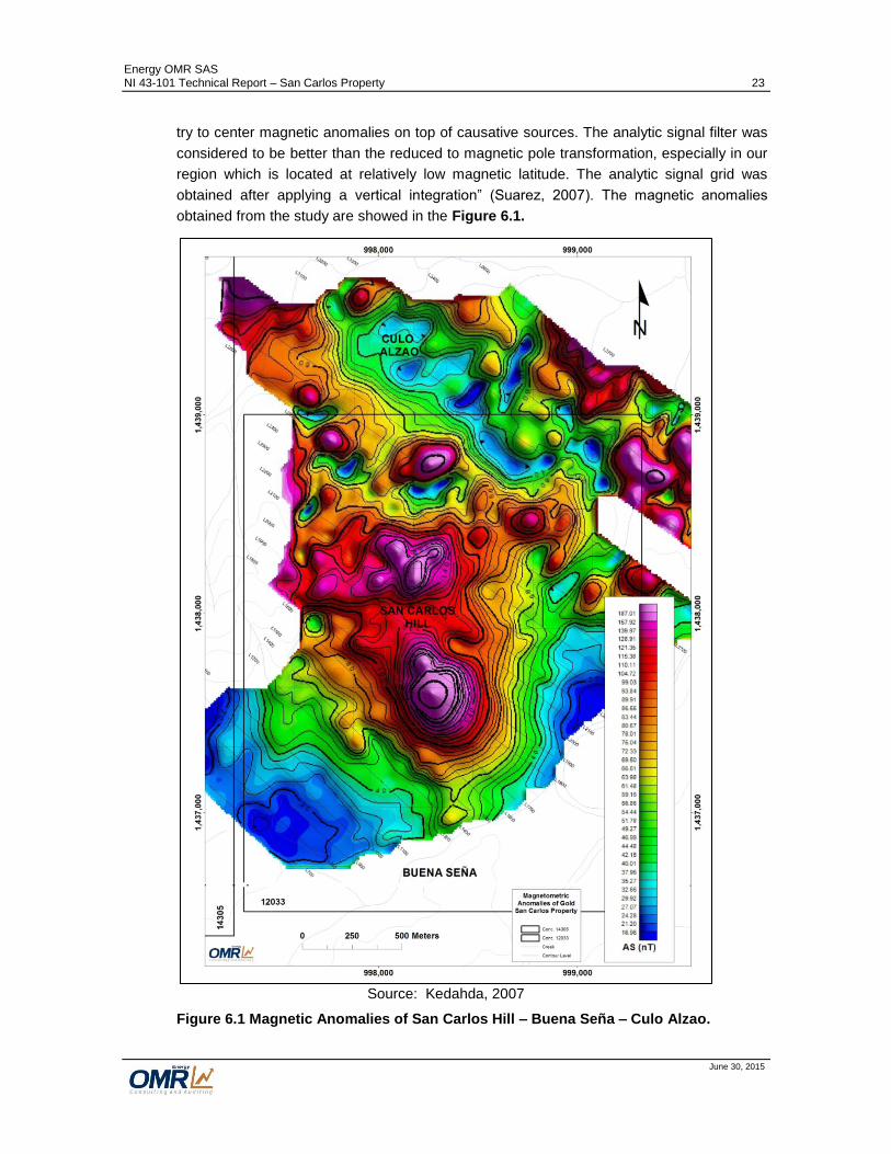
Energy OMR SAS NI 43-101 Technical Report – San Carlos Property 23
June 30, 2015
try to center magnetic anomalies on top of causative sources. The analytic signal filter was
considered to be better than the reduced to magnetic pole transformation, especially in our
region which is located at relatively low magnetic latitude. The analytic signal grid was
obtained after applying a vertical integration” (Suarez, 2007). The magnetic anomalies
obtained from the study are showed in the Figure 6.1.
Source: Kedahda, 2007
Figure 6.1 Magnetic Anomalies of San Carlos Hill – Buena Seña – Culo Alzao.

Energy OMR SAS NI 43-101 Technical Report – San Carlos Property 24
June 30, 2015
The result of this study shows various sectors with magnetometric anomalies. There are 2
types of magnetometric anomalies, the first related to the lithological composition of the
rocks, such as andesitic lavas outcropping in the NW part; the orthogneiss and andesitic
dikes that crop in the northern part, in the field found that these rocks have magnetic
susceptibility associated with primary lithological composition, these rocks generally show
no significant alteration or mineralization, (Suarez, 2007).
The second type of anomaly is found in the crests tops of mountains, where exits a
rhyolitic-rhyodacitic sequence, we know that these rocks have no within their lithological
composition elements presenting magnetic susceptibility, so it is associated with a
mineralizing event (Suarez, 2007)
Given the distribution of the two anomalous peaks in this sector, a central corridor is
created between these, with lower values, where it is believed may have happened later
replacement of magnetite by sulphides in a second mineralizing event. (Suarez, 2007) .
Guillermo Rodríguez (2007), a Colombian senior Geophysicist, interpreted the following
from the results of the magnetic study:
A prominent N-S structure in the southeast portion of the map.
An E-W structure splitting the magnetic anomaly spatially relates to the San Lucas
Hill.
Evidence for three well defined magnetic domains: A domain with low magnetic
activity in the South and East side of the map which surrounds the magnetic
anomaly related to the San Carlos Hill. This domain is related to volcano-
sedimentary rocks with low magnetization.
In the northern section of the map the magnetic field also shows low magnetic
activity with the exception of local highs observed that relate to shallow sources
(according to the 2nd Vertical derivative map) that are interpreted as intercalations
of volcanic rocks with the predominant metamorphic rocks that are known to be in
the northern side of the area.
The third domain, located in the center of the map, relates to the area with higher
magnetic intensity and it is spatially correlated with the topographically higher areas
of the map. This is the area where most of the work was completed by the Joint
Venture and also where the most interesting geochemical anomalies are located.
Geologically, this domain correlates with the volcanic and volcano-sedimentary
rocks with a higher content of magnetite.
The E-W structure mentioned previously is interpreted as a relative low that splits in
two the magnetic anomaly observed in this domain. The decrease in magnetization
producing this low is interpreted as a more intense hydrothermal alteration in this
particular area that destroyed the magnetite.
The E-W structure mentioned previously is interpreted as a relative low that splits in two the
magnetic anomaly observed in this domain. The decrease in magnetization producing this

Energy OMR SAS NI 43-101 Technical Report – San Carlos Property 25
June 30, 2015
low is interpreted as a more intense hydrothermal alteration in this particular area that
destroyed the magnetite.
Geochemical Sampling
The Joint Venture carried out soil and rock sampling in San Carlos Hill – Buena Seña –
Culo Alzao area. Table 6.1 presents the quantity of samples collected.
Table 6.1 Geochemical Samples collected by the Joint Venture
1. Soil Sampling
A systematic soil sampling included 80 samples. An Auger was used to obtain samples at
a depth of 2.5 m, all these samples were taken on horizon B. The thick layer of soil that
exceeded the limit of auger was taken as limiting in many cases. Sampling was done in the
peaks of San Carlos Hill, with the intention of determining the extent and content of Au in
soils. As a result, the anomaly of gold shown in Figure 6.2 resulted in an average of 0.73
g/t Au (Suarez, 2007).
No. of Samples
Soil Stream Sediments Rocks
(Surface – Tunnels)
80 ------- 190

Energy OMR SAS NI 43-101 Technical Report – San Carlos Property 26
June 30, 2015
Source: B2Gold, 2007
Figure 6.2 Soil Sampling Results of the Joint Venture Exploration Campaign
2. Rock Sampling
From August 2006 to June 2007, a first systematic campaign was achieved by the Joint
Venture. During this campaign were taken 190 rock samples, mainly on structures like
veins, veinlets, zones of stockworks, oxidized zones and in areas of dissemination of
sulphides.
The results were variable, and the sampling on veins resulted in erratic values of gold of up
to 11 g/t Au. In zones with veinlets density and dissemination of sulphides, the values were
typically less than 0.5 g/t Au, Figure 6.3.
N
Au in Soils
(ppm)
San Carlos HIll

Energy OMR SAS NI 43-101 Technical Report – San Carlos Property 27
June 30, 2015
Source: B2Gold, 2007
Figure 6.3 Rock Sampling Results of the Joint Venture Exploration Campaign.
3. Drilling
The Joint Venture during a diamond drilling campaign in 2007 completed 993.9 m, 6 drill
holes (HQ core size). The recoveries in sectors were hit hard by high fracturing governing
a common pattern in all holes (Suarez, 2007). Table 6.2 presents the summary of the
location and aptitude of the drill holes.
The drilling campaign on 2007 was focused on the porphyry type mineralization (Au-Cu) at
San Carlos Hill.
The information of these 6 drill holes were known through the reports of the Joint Venture,
and include logs and assays spreadsheets. None of data to validate is available. Figure
6.4 presents the location and traces of these drill holes.
Au in Rocks
(ppm)
N
San Carlos HIll

Energy OMR SAS NI 43-101 Technical Report – San Carlos Property 28
June 30, 2015
Table 6.2 Summary of Drill Holes completed by the Joint Venture at San Carlos Hill
Hole No. East (m) North (m) Elevation
(m) Azimuth
(°) Dip (°)
Depth (m)
SC-DDH-09 998,476.581 1,437,886.50 256 128 -50 169.35
SC-DDH-10 998,090.716 1,437,986.45 335 128 -60 174.95
SC-DDH-11 998,191.558 1,437,907.18 380 128 -70 189.65
SC-DDH-12 998,265.986 1,438,079.10 340 128 -60 168.30
SC-DDH-13 997,926.669 1,437,986.84 300 128 -60 201.65
SC-DDH-14 997,926.986 1,438,119.88 290 128 -60 90.00
Total meters drilled 993.90
Note: Bogota Zone Coordinates System

Energy OMR SAS NI 43-101 Technical Report – San Carlos Property 29
June 30, 2015
Figure 6.4 Location of Drill Holes completed by the Joint Venture at San Carlos Hill.
The Table 6.3 shows the general results of the drilling campaign of the Joint Venture.
Although exists alteration of the rocks and there is mineralization in veinlets, stockworks

Energy OMR SAS NI 43-101 Technical Report – San Carlos Property 30
June 30, 2015
and dissemination, the gold grades obtained from the drill holes performed were not
positive.
Table 6.3 Drilling Results of the Joint Venture Campaign, 2007
Hole No. Zone Comments / Results
SC-DDH-09 Breccia Zone Without interesting values. 17 ppb Au average
SC-DDH-10 West of the San Carlos Hill
10m @ 0.71g Au\t 24m @ 0.16g Au\t
SC-DDH-11 San Carlos Hill 48m @ 0.33g Au\t 20m @ 0.31g Au\t
SC-DDH-12 San Carlos Hill 42m @ 0.233g Au\t
SC-DDH-13 West of San Carlos Hill 30m @ 0.237g Au\t
SC-DDH-14 West of San Carlos Hill Without interesting values. 41 ppb Au average
6.2.2 Exploration Works of Orofino Gold Corporation, 2011
James, M. (2011) reported rock sampling works along creek focused in the areas of San
Carlos Hill, Culo Alzao and Buena Seña. There were sampled 33 sites, including surface
and artisanal underground workings.
“In Title 12033 we have been locating, describing and sampling veins and mineralized
outcrops. We have visited all active and some abandoned mines. Other abandoned mines
are inundated or too dangerous to enter. There are a few areas with abandoned works that
have not been studied but 90% of the areas with known Au resources have been visited”
(James, 2011).
James (2011) reported approximately 22 active artisanal mines at Buena Seña – San
Carlos Hill – Culo Alzao. Tenors from 1.5 to 37 g/t Au were obtained from around 12 -15
veins with mining history, while in the 7 principal veins which include Mina Loca, Mina
Agua, Mina Ancha, Mina San Carlos, Mina Arete Templado, Mina Buena Seña, Mina
Comité and Mina Culo Alzado, the values tend to fall in the 10 - 40 g/t Au class. There are
stockwork systems, high sulphidation veins and mineralized wall rock that make up
potentially high volumes of material for a large scale underground vein or elongate open pit
mine in Title 12033 (James, 2011).
6.3 Historical Production
Artisanal gold mining has been performed for over 200 years all around the district of San
Lucas that is considered as one of the more prolific gold mining districts of Colombia with
up to 9 t of gold produced per year, reaching the 35% of the Colombian production of gold
(Pernett, 2011). According to the Colombian Mining Information System

Energy OMR SAS NI 43-101 Technical Report – San Carlos Property 31
June 30, 2015
(www.simco.gov.co) the reported production of gold between 2003 and 2013 was 24,000
Au Oz for the Municipalities of Rio Viejo and Norosí, and 18,100 Au Oz for the Municipality
of San Martin de Loba between 2001 and 2013 with not continuous records.
Leal-Mejía (2011) mentions that the veins at San Carlos Hill - Buena Seña have been
exploited for more than 30 years by artisanal miners, producing about 1,300,000 oz of Au.
Additional to the vein deposits, some alluvial deposits have been exploited in the Property,
and not historical data of the production is available.
6.4 Historical Mineral Resource Estimates
No 43-101 compliant mineral resource estimates has been carried out on the Property.

Energy OMR SAS NI 43-101 Technical Report – San Carlos Property 32
June 30, 2015
7 Geological Setting and Mineralization (Item 7)
7.1 Regional Geology
San Carlos project is located in the San Lucas Mountain Range (Serranía de San Lucas -
Serranía) that is situated to the NE of the main mountain range of the Colombian Central
Cordillera of the Andes Mountains. This mountain range contains a heterogeneous
lithological composition with a historical evolution since the Mesoproterozoic to the
Holocene with a generation of metamorphic, igneous and sedimentary rocks including
mineralization (Figure 7.1).
The Precambrian medium to high grade metamorphic rocks of the gneiss of San Lucas are
composed by banded quartz-feldspar gneisses with bands of biotite and hornblende.
Outcrops of this unit are found to the north and the western border of the San Lucas
mountain range, defining an N-S belt of 160 km long by 20 km width (Cediel and Caceres,
2000; Gomez et al., 2007). Low-grade metamorphic rocks of the Pinillos and La Virgen
units of the early Paleozoic crop out to the west in a N-S band, comprising black granitic
schists (Figure 7.1). This unit is correlated with the metamorphic basement of the
Colombian Central Cordillera of the Andes Mountains (i.e. Cajamarca and Valdivia groups)
and the Quetame Group of the Colombian Eastern Cordillera, respectively (Clavijo et al.,
2008).
Rift-related sedimentary sequences deposition caused by the extensional tectonics
associated with the late Paleozoic to middle Cretaceous Bolivar Aulacogen is accompanied
by incipient subaerial dacite-andesite explosive volcanism during late Paleozoic to early
Jurassic (Bogotá and Aluja, 1981; Clavijo et al., 2008). Outcrops of these rocks are found
in small areas to the N and SE borders of the mountain range (Cediel and Caceres, 2000;
Gómez et al., 2007).
The deposition of early middle Jurassic volcanoclastic sequences of the Norean formation
(Clavijo, 1996) in the region is associated to the Jurassic magmatic belt development
through the Colombian Andes. This unit forms a N-S band covering the entire eastern
border of the mountain range (Leal-Mejía, 2011). Intercalation of volcanic rocks and
sedimentary deposits form a thick sequence (aprox. 4000 m) as a product of a period of
explosive volcanism (Clavijo et al., 2008).
The pre-existing volcanoclastic and other rocks are intruded by the early Jurassic formation
Norosí-San Martín Batholith. Outcrops of this unit are found along a N-S trending belt
parallel to the volcanoclastic deposits to the west (Leal-Mejía, 2011).
Middle to late Jurassic magmatism is represented by the intrusion of the Segovia Batholith
to the west of the Serranía and other minor hypabyssal intrusives affecting mainly the
volcanoclastic sequence (Clavijo et al., 2008).
Relicts of late Jurassic sedimentation, following the Jurassic magmatism crops out in small
lenses along the eastern border of the Serranía (i.e. Arenal Formation, Clavijo, 1996).

Energy OMR SAS NI 43-101 Technical Report – San Carlos Property 33
June 30, 2015
Pliocene to present sedimentary deposits partially cover the flanks of the Serrania,
associated with the sedimentary basins of the Magdalena and Cauca Rivers (Cediel and
Caceres, 2000; Gómez et al., 2007).
Source: Leal-Mejía, 2011
Figure 7.1 Geology of the Serranía de San Lucas Region.

Energy OMR SAS NI 43-101 Technical Report – San Carlos Property 34
June 30, 2015
7.1.1 Structural Geology
The isolated block of the Serranía exhibits a complex tectonic, delimited to the west by the
Palestina fault, to the north by the Espiritu Santo-Murrucucu fault, to the east by the
Morales fault and to the south by the Cimitarra fault (Clavijo et al., 2008). Figure 7.2.
Source: AGS-Nativa, 2013
Figure 7.2 Major Faults of the Serranía de San Lucas Region.
Bogotá and Aluja (1981) divide the Serranía in three areas differentiated by the style of
deformation:
1- Eastern Zone; to the east of the Serranía towards the Magdalena valley. Characterized
by a marked N-S to NE-SW structural trend. This zone is associated to the western
part of the Magdalena valley graben.
2- Central Zone; comprising the Eastern flank of the mountain range. This zone is limited
in both eastern and western sides by N-S to NE-SW faults. To the west faults are
related to the Palestina Fault System, which mark the contact between the Jurassic
intrusive rocks of the Norosí - San Martin Batholith and the Mesoproterozoic and early

Energy OMR SAS NI 43-101 Technical Report – San Carlos Property 35
June 30, 2015
Paleozoic metamorphic rocks to the west. Two major conjugated fault systems
following N50 - 60°E and N20 - 30°W directions are the most important and a third N-S
direction subordinated system would be associated with the tectonic reactivations.
3- Western Zone; comprising the Western flank of the mountain range. This zone is
characterized by a N-S trend associated with the Palestina Fault System, with a
secondary conjugated fault system following N45°E and N40°W directions. These
structures affect mainly the N-S belts of Mesoproterozoic and Paleozoic metamorphic
rocks. The movements of the N-S structures of the Palestina Fault system are
considered to be responsible for reactivation of the N50-60°E structures of the Central
Zone.
Tectonic Evolution
Clavijo et al. (2008) presents a summary of the geological history and tectonic evolution of
the Serranía region, the northern middle Magdalena valley and the north-western border of
the Eastern Cordillera.
He defines eight different tectono-stratigraphic events for this broad region from the Meso-
Proterozoic to present times.
Two early metamorphic events affected the region and are well-recorded by high- and low-
grade metamorphic rocks of Meso- to Neo-Proterozoic and early Paleozoic ages associated
to the Orinoco and Quetame orogenies, respectively.
The development of extensional tectonic regime during the late Paleozoic to the early
Cretaceous associated with the Bolivar Aulacogen are well-recorded by extensive
magmatic and associated volcanic-sedimentary rocks covering most of the Serranía area
(e.g. Norosí - San Martin Batholith and Norean Formation), which are related to four
different tectono-stratigraphic events from late Triassic to late Cretaceous, (Clavijo et al.
2008).
A tectonic inversion event during the Eocene - Oligocene associated with the collision of the
Farallones Plate with South-America, is regarded as responsible for the uplift of the
Serranía and also for the inversion of pre-existing normal faults and structures in this
compressive tectonic regime.
The final Miocene to present tectono-stratigraphic event is regarded as responsible for the
complete inversion of Jurassic and Cretaceous sedimentary basins as a response to
generalized regional deformation and uplifting during the Northern Andean Orogeny.

Energy OMR SAS NI 43-101 Technical Report – San Carlos Property 36
June 30, 2015
7.2 Property Geology
7.2.1 Lithology
Gneiss
The distribution of the Mezoproterozoic Gneiss occurs covering most of the north zone of
the area study and in isolated hills that stand in your own flat relief to the south zone of the
Property, Figure 7.4. The gneiss consists of thin continuous and undeformed strips up to 5
cm thick, composed by quartz, feldspar, plagioclase, biotite, amphibole and iron oxides.
The banding is defined by white bands composed of quartz and plagioclase sodium and
dark bands composed of amphibole (hornblende), mica (biotite) and iron oxides. Figure 7.3
shows core of gneiss in San Carlos hill.
Source: Anglomerican, 2013
Figure 7.3 Gneiss in Drill Hole SAC13DDH001, 550.50 m.
To the North of San Carlos Hill, the preferred banding is N10-20°W / 67°NE, where
outcrops a quartz feldspar-biotite gneiss with white bands composed by quartz and feldspar
inter-grown by granoblastic texture, and dark bands with granoblastic texture to
lepidoblastic texture, formed by mafic minerals, biotite and amphibole that print the banded
texture.
The Norean volcanic complex
This unit is widely distributed throughout the study area and generates morphologies of hills
moderate to high slope, and aligned in direction NE. The volcanic complex brings together
a variety of extrusive rocks of flow and pyroclastic rocks mixed and interbedded with
epiclastic rocks. It is composed of lapilli tuffs and crystal ash; crystal-lithic ash, lava and

Energy OMR SAS NI 43-101 Technical Report – San Carlos Property 37
June 30, 2015
lapilli tuffs, that interspersed with agglomerates and epiclastic rocks, sandstones and
tuffaceous siltstones. Usually appear pseudo-stratified in medium to thin levels, in
continuous parallel flat geometry, with moderate to strong inclination, affected by tectonism.
The following is the description of each level that composes the Norean Volcanic Complex
in the Property:
Pyroclastic and epiclastic rocks
These rocks outcrop through the property as tuffs, lavas and pseudo stratified volcanic
sediments. The arrangement of the layers has the appearance of a sedimentary sequence.
Rock fragments of glass, small crystals of quartz, plagioclase and tuffaceous rocks are
observed.
Andesitic - dacitic volcanic breccia
These rocks crop out on the West of the Property where appears with a brecciated texture,
with a cryptocrystalline vitreous matrix, with xenoliths of sedimentary and volcanic rocks. In
the breccias are observed lithics of dacitic lava of up to 4 cm with angular crystals of
rhyolite and andesite, and anhedral crystals of amphibole replaced by epidote chaotically
arranged across the rock and embedded in a matrix of microcrystalline quartz and fine
grained plagioclase.
Dacitic and rhyolitic pyroclastic rocks
These rocks appear in Buena Seña Town where crystal tuffs are observed, apparently
overlying unconformable on epiclastic rocks although the relationship could be interpreted
like an inter-stratification due to the low angle of the contact surface and the flow or
stratification planes.

Energy OMR SAS NI 43-101 Technical Report – San Carlos Property 38
June 30, 2015
Source: Modified from Anglo American, 2013
Figure 7.4 Geology of the Property.

Energy OMR SAS NI 43-101 Technical Report – San Carlos Property 39
June 30, 2015
Andesitic Lavas and Tuffs
The basal part of the known volcanic sequence is formed by lava and lithic tuffs of andesitic
composition of dark green to grey color, locally magnetic, hard and compact. The
mineralization is apparently not favorable in this unit. The alteration is weak chlorite and the
veining intensity is much lower than in the rhyolitic levels. This unit is observed at depth in
the drill holes completed in San Carlos Hill, Figure 7.5.
Source: Anglo American, 2013
Figure 7.5 Andesitic Tuff, Cut by Quartz-Monzonite-Diorite Porphyritic Micro-Dike. Drill Hole SAC13DDH002, 621.10 m.
Rhyodacitic and Riolitic
This unit is common in the south part of the Property and is formed by tuffs of fine to coarse
ash and lithic tuffs lapilli type with lithics of 1 to 4 mm diameter, locally with flow structures
and gas cavities. This level present a good intensity of veinlets and stringers associated
with low grade mineralization of gold, with Quartz-sericite and argillic alteration associated.
Andesitic Lavas
These lavas are the cover of the low grade mineralization of gold and are characterized by
siliceous and less siliceous and magnetic lavas. Some lavas have scarse lithics of less
than 2 mm diameter and some levels of volcanic agglomerates with siliceous matrix.
Mineralization is not observed in these lavas.
Rhyodacitic Crystal Tuffs
Outcropping to the South of the San Carlos hill, this unit is composed by ash tuffs, with
lithics of 1-2 mm diameter, locally volcanic glass, ortosa crystals and biotite. Typically with
violet matrix. These rocks are not hydrothermally altered and without mineralization
associated.
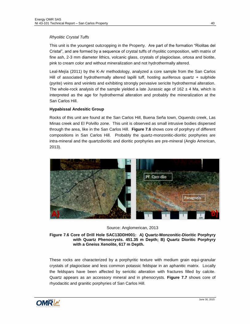
Energy OMR SAS NI 43-101 Technical Report – San Carlos Property 40
June 30, 2015
Rhyolitic Crystal Tuffs
This unit is the youngest outcropping in the Property. Are part of the formation “Riolitas del
Cristal”, and are formed by a sequence of crystal tuffs of rhyolitic composition, with matrix of
fine ash, 2-3 mm diameter lithics, volcanic glass, crystals of plagioclase, ortosa and biotite,
pink to cream color and without mineralization and not hydrothermally altered.
Leal-Mejía (2011) by the K-Ar methodology, analyzed a core sample from the San Carlos
Hill of associated hydrothermally altered lapilli tuff, hosting auriferous quartz + sulphide
(pyrite) veins and veinlets and exhibiting strongly pervasive sericite hydrothermal alteration.
The whole-rock analysis of the sample yielded a late Jurassic age of 162 ± 4 Ma, which is
interpreted as the age for hydrothermal alteration and probably the mineralization at the
San Carlos Hill.
Hypabissal Andesitic Group
Rocks of this unit are found at the San Carlos Hill, Buena Seña town, Oquendo creek, Las
Minas creek and El Polvillo zone. This unit is observed as small intrusive bodies dispersed
through the area, like in the San Carlos Hill. Figure 7.6 shows core of porphyry of different
compositions in San Carlos Hill. Probably the quartz-monzonitic-dioritic porphyries are
intra-mineral and the quartzdioritic and dioritic porphyries are pre-mineral (Anglo American,
2013).
Source: Anglomerican, 2013
Figure 7.6 Core of Drill Hole SAC13DDH001: A) Quartz-Monzonitic-Dioritic Porphyry with Quartz Phenocrysts. 451.35 m Depth; B) Quartz Dioritic Porphyry with a Gneiss Xenolite, 617 m Depth.
These rocks are characterized by a porphyritic texture with medium grain equi-granular
crystals of plagioclase and less common potassic feldspar in an aphanitic matrix. Locally
the feldspars have been affected by sericitic alteration with fractures filled by calcite.
Quartz appears as an accessory mineral and in phenocrysts. Figure 7.7 shows core of
rhyodacitic and granitic porphyries of San Carlos Hill.

Energy OMR SAS NI 43-101 Technical Report – San Carlos Property 41
June 30, 2015
Source: Anglomerican, 2013
Figure 7.7 A) Rhyodacitic Porphyry with Quartz Crystals in Drill Hole SAC13DDH002, 686 m depth. B) Granitic Porphyry with UST Texture (unidirectional silicification texture), in Drill Hole SAC13DDH001 416 m Depth.
These hypabyssal rocks show intrusive contacts with the volcanics of the Norean formation.
The presence of porphyritic andesitic and dacitic dikes and silos are observed and evidence
the sub-volcanic events cutting the tuffs and epiclastic stratification.
Dating of these rocks show ages between 158 ± 12Ma y 144.4 ± Ma, of the late Jurassic.
Dacitic to Andesitic Hypabissal Rocks
Characterized by a porphyritic texture and an aphanitic matrix with phenocrysts of
plagioclase and locally rounded quartz of intermediate grey color of dacitic to andesitic
composition. Outcrops of these rocks are not found in the Property, but some drill holes
have intercepted these rocks in San Carlos Hill.
Andesitic Dikes
Compact rocks of dark green color with aphanitic texture and magnetic response.
Alteration and mineralization is absent. The dikes are observed cutting the ortho-gneiss
and the volcanic sequence and apparently was emplaced after the mineralization event.
Hydrothermal Breccias
Possibly of Jurassic age, the breccias consist of quartz matrix and angular to sub-angular
fragments of granodioritic and granitic intramineral porphyries. It also includes magmatic
breccias with matrix of granodioritic porphyry and subangular clasts of sub-angular granitic
and granodioritic porphyries. (Anglo American, 2013). Figure 7.8 shows core of
hydrothermal breccia of San Carlos Hill.

Energy OMR SAS NI 43-101 Technical Report – San Carlos Property 42
June 30, 2015
Source: Anglomerican, 2013
Figure 7.8 Hydrothermal Breccia with Crypto - crystalline Quartz in Drill Hole SAC13DDH001, 351 m Depth.
Quaternary Deposits
Alluvial deposits of channel are observed through the Property along the creeks and rivers
and are formed by sand, gravel and blocks in the mountainous areas and sand and silt in
the plane areas. Some colluvial type deposits are observed at San Carlos Hill composed
by angular fragments of tuffs.

Energy OMR SAS NI 43-101 Technical Report – San Carlos Property 43
June 30, 2015
7.2.2 Structural Geology
Structurally, the San Carlos Property is part of the Eastern zone of the Serranía de San
Lucas characterized by a marked N-S to NE-SW structural trend. The following main
trends control the mineralization in San Carlos Property:
- The N40°E trend, parallel to the main trace of the Espiritu Santo - Murrucucú and
the Cimitarra fault systems (Figure 7.9), controlling the mineralization in veins in
San Carlos hill;
- N-S and N10°W structures controlling mineralization in El Azul and Mina Culo
Alzao.
Source: Mera-Carvajal, 2013
Figure 7.9 Structural Scheme of the San Lucas Mountain Range
San Carlos Property
Cimitarra Fault
Bucaramanga – Santa Marta
Fault
Palestina Fault
Espiritu Santo-Murrucucú Fault
Morales Fault
km 0
N
20

Energy OMR SAS NI 43-101 Technical Report – San Carlos Property 44
June 30, 2015
Suarez, 2007 describes other structures in San Carlos as follows:
- N50W faults, sinistral type, have generated staggered displacements of the
volcanic sequence in San Carlos (Figure 7.10);
- N40E fault, controlling Veta Ancha vein, younger than the previous N50°W as it has
not been displaced,
- N55E fault, observed to the E-SE flank of the San Carlos Hill;
- E-W fault, controlling the Piloto creek to the north of the San Carlos Hill.
7.2.3 Mineralization
Based on the available exploration information, the following three areas have the best
mineral potential of the Property and will be described separately in this section.
- San Carlos Hill – Buena Seña
- Culo Alzao
- El Azul
Other areas like La Nigua and other isolated areas through the Property have artisanal
mining but the exploration information is poor, and is required additional works, Figure 7.4.
San Carlos Hill – Buena Seña
The style of mineralization in the San Carlos Hill is either disseminated or as veins. The
disseminated mineralization of gold found at San Carlos Hill is low grade and has not
economic importance. The mineralization of gold in veins is of high grade and has not been
studied appropriately and it is necessary carry out a complete exploration program to define
the mineral potential of the veins.
Anglo American, 2014, defined an area of 2 km by 1.4 km of mineralization/hydrothermal
alteration contained in the gneiss and in the Norean complex. Into the veins is commonly
observed the leached zone of brecciated rock with fragments of tuffs, veins and veinlets of
milky and hyaline quartz, limonitic cement/matrix with jarosite – hematite – goethite – gold -
silver, and in some structures there is preservation of base metals (Cu-Mo-Pb-Zn). The
host rocks are andesitic, latitic and dacitic tuffs with halos of sericite – illite alteration close
to the structures and quickly passing to illite - chlorite ± pyrite affecting only some meters on
both sides of the veins. Figure 7.10 presents the geology and hydrothermal alteration of
the San Carlos Hill – Buena Seña area.

Energy OMR SAS NI 43-101 Technical Report – San Carlos Property 45
June 30, 2015
Source: Modified from Anglo American, 2013
Figure 7.10 Geology and Alteration of San Carlos Hill – Buena Seña Area

Energy OMR SAS NI 43-101 Technical Report – San Carlos Property 46
June 30, 2015
The zonation of the hydrothermal alteration is clear. The alteration is more intense on the
higher side of the hill where is observed intense sericitic – supergene kaolinite, changing in
the periphery of the hill to moderate illite – sericite, then to illite – chlorite ± pyrite and finally
to chlorite – epidote ± pyrite. On the higher side of San Carlos Hill is observed a 30 m by
80 m strip of strong sub-parallel veining type AB and B with secondary biotite and K
feldspar halo including disseminated pyrite (up to 1%) and hematite and goethite, (Anglo
American, 2014). Figure 7.11 shows the veining schema of anAu-rich porphyry, (Sillitoe,
2000).
Source: Sillitoe, 2000
Figure 7.11 Schema of Typical Dense Veinlet Stockwork in Au-Rich Porphyry Deposit Showing Sequential Formation of Different Vein-Types.
Hydrothermal Alteration
Sericitic Alteration: Pervasive sericitic alteration is common affecting the volcano-
sedimentary sequence rocks. In the veins, sericite is observed with quartz and ± Pyrite,
(Figure 7.12). Quartz D-type veining with suture of pyrite - chalcopyrite ± Molybdenum and

Energy OMR SAS NI 43-101 Technical Report – San Carlos Property 47
June 30, 2015
sericitic halo is observed in the andesitic tuffs and less common in the intra-mineral
porphyries.
Source: Leal-M
Source: Leal - Mejía, 2011
Figure 7.12 Left: Fine – Grain Sericite Replacing All the Rock, with a Vein Filled up with Larger Crystals of Sericite, San Carlos; Right: Image in Crossed Polars.
Intermediate Argillic Alteration: Kaolinite is common in many parts of the hill and is found
as white soft aggregates composed by small crystals (cryptocrystalline range) , inter-grown
with fine-grained quartz, and replaced by associations of quartz - sericite (Leal-Mejía,
2011), Figure 7.13. In the first meters of drill hole SAC13DHH002 is observed kaolinite -
smectite ± chlorite ± sericite in the andesitic tuffs and in the granitic porphyry with pyrite
contents of up to 3%, being apparently the lower part of a lithocap, (Anglo American, 2014).
Source: Leal-Me
Source: Leal - Mejía, 2011
Figure 7.13 Left: Fine – Fine-Grained Kaolinite Alteration (kao) Enveloped and Crosscut by Late Sericite (ser). San Carlos Hill; Right: Image in Crossed Polars.

Energy OMR SAS NI 43-101 Technical Report – San Carlos Property 48
June 30, 2015
Propylitic Alteration: This alteration is common in the volcanoclastic host rock including
Epidote + Chlorite + Calcite + Pyrite ± Chalcopyrite ± Magnetite. Sulphides are common
with up to 2% content of predominantly pyrite. In the borders of the intra-mineral porphyries
is observed Epidote – Chlorite – Pyrite overprinting the potassic alteration, Anglo American,
2014. Chloritic alteration is observed filling veins or overprinting most of the alteration
minerals, including K - feldspar and biotite, sodic-calcic, and sericite alterations, associated
with sulphide mineralization of pyrite and sphalerite (Leal-Mejía, 2011), see Figure 7.14.
Source: Leal-Mejía, 2011
Figure 7.14 Sericitic Alteration (ser) Crosscut by Associations with Pyrite (opaque) and Chlorite (green).
Potassic Alteration: It is observed in the drill hole SAC13DDH001 as pervasive K feldspar
in the granitic, granodioritic and rhyodacitic porphyries including A - type veining of
cryptocrystalline quartz sinuous and discontinuous. The B - type veins are composed by
quartz – molybdenum – chalcopyrite – pyrite associated to the porphyries and
volcanoclastic host rocks. Figure 7.15 presents the potassic alteration affecting the
porphyries in San Carlos Hill.
Potassic alteration is normally overprinted mainly by sericite, chlorite and sodico - calcic
alterations. Leal-Mejia observed secondary feldspar replacing early primary magmatic K-
feldspar crystals, biotite alterations occurring as small relicts into chlorite and potassic
alteration enriched in magnetite crystals, sometimes replaced by pyrite. In quartz veins K-
feldspar is observed with pyrite and minor amounts of molybdenite and chalcopyrite. Figure
7.16.

Energy OMR SAS NI 43-101 Technical Report – San Carlos Property 49
June 30, 2015
Secundary biotite, K feldspar, retrograde chlorite and magnetite veinlets of magnetite are
observed in the quartz - dioritic, quartz - monzonitic and monzodioritic porphyries.
Source: Anglo American, 2014
Figure 7.15 A) Granitic Porphyry with Strong K feldspar Alteration, A-Type Veins,A-Type Veins and UST (Unidirectional Solidification Texture) Texture, in Drill Hole SAC13DDH001, 416 m depth; B) Granodioritic Porphyry with Moderate K Feldspar Alteration, Secondary Biotite, Quartz – Molybdenum - Pyrite B - Type Veins Cutting Quartz - K Feldspar – Chalcopyrite - Pyrite AB - Type Vein in Drill Hole SAC13DDH001, 451.35 m Depth.
Source: Anglo American, 2014
Figure 7.16 Vein Infilling with Quartz (qtz), K - Feldspar (KF), Chlorite (green) and Molybdenite (mb). San Carlos Hill, Core 1.

Energy OMR SAS NI 43-101 Technical Report – San Carlos Property 50
June 30, 2015
Potassic -Calcic Alteration: At 268 m depth in drill hole SAC13DDH_001 are observed the
andesitic tuffs with moderate to strong alteration with disseminated secondary biotite, with
veinlets of secondary biotite inter - grown with epidote, AB - type veinlets of quartz with
suture of molybdenum ± chalcopyryte and halo of K feldspar – epidote – chalcopyrite
toward the borders of the K feldspar – biotite alteration, Figure 7.17, (Anglo American,
2014).
Source: Anglo American, 2014
Figure 7.17 Andesitic Tuff with Potassic – Calcic Alteration.
Leal-Mejia (2011) calls sodic-calcic alteration in San Carlos the presence of albitic
plagioclase in association with secondary fibrous pale greenish amphibole. This alteration
is observed filling veins, sometimes in association with epidote and pyrite, although pyrite is
formed early. Uralitic amphibole may constitute the vein infilling and the selvages and in
other cases may replace intensively the rock. (Leal-Mejía 2011), Figure 7.18.
Source: Lea
l-Mejía, 2011
Figure 7.18 Left: Image in Crossed Polars. Right: Image in Crossed Polars. Note That Amphibole is Found Into the Veinlets Cutting Across Pyrite. Note Higher Interference Colors in Amphibole.

Energy OMR SAS NI 43-101 Technical Report – San Carlos Property 51
June 30, 2015
Albitic alteration. This alteration is observed in the andesitic tuffs in drill holes
SAC13DDH001 and SAC13DDH002 where the association of moderate potassic – calcic
alteration in EB - type veinlets with pyrite – chalcopyrite with halo of K feldspar – albite ±
calcite is overprinting the moderate secondary biotite alteration in the andesitic tuffs. This
alteration is commonly observed in the borders of the K feldspar alteration, Figure 7.19,
(Anglo American, 2014).
Source: Anglo American, 2014
Figure 7.19 Andesitic Tuff with K Feldspar – Sodic Alteration Overprinting the Moderate Secondary Biotite Alteration in Drill Hole SAC13DDH001, 294 m Depth.
The Figures 7.20 and 7.21 show the vertical sections and the interpretation of the drill
holes SAC13DHH001 and SAC13DHH002, (Anglo American, 2014).

Energy OMR SAS NI 43-101 Technical Report – San Carlos Property 52
June 30, 2015
Source: Anglo American, 2014
Figure 7.20 Schematic Vertical Section, Drill Hole SAC13DHH001.
Source: Anglo American, 2014

Energy OMR SAS NI 43-101 Technical Report – San Carlos Property 53
June 30, 2015
Figure 7.21 Schematic vertical section, drill hole SAC13DHH002.
Systems of Veins
The veins have two main directions, N50° - 60°E and N20° - N45°E and are sub-vertical
predominantly. The width of the veins varies from centimeters up to locally 2 m thickness.
Other vein sets with poor mineralization (fracture filling) have N - S and E - W directions
(Leal-Mejía, 2011).
To the SE of the San Carlos Hill, framed by two structures of N30°E and N45°E trend, a
group of mineralized structures (Veins) with directions varying from N30°E to N55°E is
found. Figure 7.22.
The vein “Veta Ancha” is located in the eastern side of the San Carlos Hill, with a
discontinuous horizontal extension of close to 1,200 m (Suarez, 2007), N37°E strike and
variable dipping and up to 72°NW in the northern part and changing to 75°SE to the south.
The width is varying from 0.4 to 1.7 m and is characterized infilling of iron oxides – breccia
clasts. In the Aguas Claras area, the vein is characterized by quartz-pyrite and grey color
in the fresh rock, (Camacho, 2011).
Other sub-parallel veins to the Veta Ancha structure are found to the South and SE of the
San Carlos Hill. These structures have variable directions between N25°E to N55°E, and
dipping typically to the SE from 70° to 90° and widths varying between 0.10 to 1 m. Figure
7.22 shows the interpreted mineralized structures in the area of San Carlos Hill - Buena
Seña.
Veinlet systems of NW, NE and E-W strikes are frequently irregular, discontinuous, with
ramifications and without systematic distribution in the vulcanoclastic rocks. The main
concentration of these veining systems is located on the higher side of San Carlos hill and
around forming small bodies. The veins and veinlets width vary from few millimeters to
some centimeters, accompanied by micro - breccias and poor dissemination.
The composition of the veins and veinlets is variable: pyrite, quartz-pyrite, iron oxides,
quartz-iron oxides, and sericite and illite alterations in the veins and host rocks.
To the NNE of the San Carlos Hill and at the border of the concession No. 12033, is the
area of Las Palmeras, where a vertical vein with direction N17°E is being exploited in
different tunnels with a length of 350 m and 0.3 m thickness, characterized by iron oxides
and quartz (Suarez, 2011). In the mine La Palmera, is being exploited a vertical NS vein.
Outside of the concession No. 12033, in the area of Los Mangos, where appears a
structure, there are some veins of direction N16°E and 80°SE dipping, with 130 m
extension and width of 0.6 m, with infilling of iron oxides – pyrite – quartz – clays
(Camacho, 2011).

Energy OMR SAS NI 43-101 Technical Report – San Carlos Property 54
June 30, 2015
Figure 7.22 Interpreted Mineralized Structures at San Carlos Hill – Buena Seña.

Energy OMR SAS NI 43-101 Technical Report – San Carlos Property 55
June 30, 2015
Culo Alzao
Culo Alzao is located to the border of the concession No. 12033 to the NNW of the San
Carlos Hill. The veins are extended to the area of the concession where some artisanal
works exist, Figure 7.23.
One of the mineralized structures is N10°W strike and vertical dipping, with an extension of
140 m and width varying from 0.3 to 0.5 m according to the exploitation works; this structure
is characterized by brecciation and formed by iron oxides – pyrite - quartz.
Another vein is N20°W strike and 80°SW dipping, with 240 m extension and average width
of 1 m, characterized by brecciation and clays – pyrite infilling.
To the west of Culo Alzao into the concession No. 14305 the mine El Cachaco is found
where is being exploited a vein N48°E strike, 85°SE dipping and 0.15 m width, that is
characterized by iron oxides and sericitic alteration in the vein and in a small halo in the
volcanic host rock.
Figure 7.23 Interpreted Mineralized Structures at Culo Alzao

Energy OMR SAS NI 43-101 Technical Report – San Carlos Property 56
June 30, 2015
El Azul
The mineralization of high grade gold veins in El Azul is hosted by gneisses and is
characterized by the association quartz (chalcedonic) – pyrite – chalcopyrite – sphalerite -
galena (Figure 7.24). The hydrothermal alteration of illite - sericite is present in halos of
few centimeters and passing quickly to chlorite - epidote ± pyrite moving away from the
veins. The veins have a longitudinal mineral zonation from the periphery with quartz, then
quartz - pyrite, then quartz – pyrite - chalcopyrite and in the inner part of the veins with
quartz – galena - sphalerite (mamatite) – chalcopyrite - pyrite. Locally some veins contain
calcite and rhodochrosite (Mera-Carvajal, 2013).
Source: Mera-Carvajal, 2013
Figure 7.24 Mineralization in El Azul. Milky Quartz – Pyrite – Chalcopyrite – Galena - Sphalerite.
At least 5 veins have been identified in El Azul (Figure 7.25). The strikes of the veins vary
from N - S to N10E and the dip from 80 to 90°. The horizontal extension observed in the
artisanal workings reach 800 m. Some veins crop out at surface and the exploited depth
observed in the artisanal workings reach 80 m depth. The miners enter to the exploitation
faces through vertical and inclined shafts. The Figure 7.26 shows the inclined shaft in El
Azul.

Energy OMR SAS NI 43-101 Technical Report – San Carlos Property 57
June 30, 2015
Figure 7.25 Interpreted Mineralized Structures at El Azul
.
Figure 7.26 Inclined Access of the Luis Florez Tunnel in El Azul.

Energy OMR SAS NI 43-101 Technical Report – San Carlos Property 58
June 30, 2015
8 Deposit Type (Item 8) The gold deposits of the Property of San Carlos are hosted in basement of gneisses of the
Serranía de San Lucas, in the Jurassic volcanoclastic sequences associated to the
intrusives of the Norean Formation (Norosi - San Martín Batholith) and in the hypabyssal
rocks observed in the drill core of the San Carlos Hill.
In the Property were identified two types of deposits. In San Carlos Hill the mineralization is
associated to a porphyry type deposit in veins and disseminated. Some high gold grade
veins can be associated to reduced intrusion-related gold deposit type in mesothermal
veins that are being exploited thorough the area in San Carlos hill, and to the north in Culo
Alzao and El Azul.
It is necessary more information of the mineralization in the veins to better understand the
genesis of the deposits. Some authors define the mineralized structures exploited in El
Azul and Culo Alzao as intermediate sulphidation ephithermal veins.
8.1 Porphyry type deposit
Porphyry type deposits are widely known as the most important source of copper,
molybdenum and gold. Porphyry systems can contain large volumes of hydrothermally
altered rock centered on porphyry Cu stocks that may also contain skarn, carbonate-
replacement, sediment-hosted, and high and intermediate-sulphidation ephitermal base and
precious metal mineralization (Sillitoe, 2010).
Porphyry Cu Systems are generated mainly in magmatic arc (including back-arc)
environments subjected to a spectrum of regional-scale stress regimes, apparently ranging
from moderately extensional through oblique slip to contractional (Tosdal and Richards,
2001).
The faults and interception of them play an important role in the formation of porphyry
systems and definition of the geometry of clusters or structurally controlled alignments of
them. This systems are associated to underlying composite plutons, at paleo - depths of 5
to 15 km, which represent the supply chamber magmas and fluids that formed the vertically
elongate (>3 km) stocks or dike swarms and associated mineralization. Individual systems
have life spans of approximately 100,000 to several million years, whereas deposit clusters
or alignments as well as entire belts may remain active for 10 million years or longer
(Sillitoe, 2010).
Alteration and mineralization can occupy many cubic kilometers of rock, and are zoned
outward from the stocks or dike swarms, which typically comprise several generations of
intermediate to felsic porphyry intrusions. Porphyry Cu ± Au ± Mo are centered on the
intrusions, whereas carbonate wall rocks commonly host proximal Cu - Au skarns, less
common Zn - Pb and/or Au skarns, and beyond the skarn front, carbonate - replacement
Cu and/or Zn – Pb - Ag ± Au deposits, and/or sediment-hosted (distal - disseminated) Au
deposits. High-sulphidation epithermal deposits may occur in lithocaps above porphyry Cu

Energy OMR SAS NI 43-101 Technical Report – San Carlos Property 59
June 30, 2015
deposits, where massive sulphide lodes tend to develop in deeper feeder structures and Au
± Ag - rich, disseminated deposits within the uppermost 500 m or so. Less commonly,
intermediate - sulphidation epithermal mineralization, chiefly veins, may develop on the
peripheries of the lithocaps. The alteration-mineralization in the porphyry Cu deposits is
zoned upward from barren, early sodic - calcic through potentially ore - grade potassic,
chlorite-sericite, and sericitic, to advanced argillic, the last of these constituting the
lithocaps, wich may attain > 1 km in thickness if unaffected by significant erosion. Low
sulphidation - state chalcopyrite ± bornite assemblages are characteristic of potassic zones,
whereas higher sulphidation - state sulphides are generated progressively upward in
concert with temperature decline and the concomitant greater degrees of hydrolytic
alteration, culminating in pyrite ± enargite ± covellite in the shallow parts of the lithocaps.
The porphyry Cu mineralization occurs in distinctive sequence of quartz - bearing veinlets
as well as in disseminated form in the altered rock between them. Magmatic - hydrothermal
breccias may form during porphyry intrusion, with some of them containing high - grade
mineralization because of their intrinsic permeability. In contrast, most phreatomagmatic
breccias, constituting maar - diatreme systems, are poorly mineralized at both the porphyry
Cu and lithocap levels, mainly because many of them formed late in the evolution of the
system (Sillitoe, 2010). Figure 8.1 presents the characteristics and spatial relations of a
porphyry system.

Energy OMR SAS NI 43-101 Technical Report – San Carlos Property 60
June 30, 2015
Source: Sillitoe, 2010
Figure 8.1 Anatomy of a telescoped porphyry Cu system showing spatial interrelationships of a centrally located porphyry Cu ± Au ± Mo deposit in a multiphase porphyry stock and its intermediate host rock.
8.2 Reduced Intrusion-related gold deposit
Lang et al. (2000) introduced the term “intrusion-related gold systems” in order to group
different mineralization styles, metal assemblages and spatial associations relative to a
causative intrusion. In 2007, Hart introduced the prefix “reduced” in order to highlight the
moderate low primary oxidation states (reduced/ilmenite - series; Ishihara, 1981) that
characterize host or associated intrusions and differentiate them from oxidized intrusion -

Energy OMR SAS NI 43-101 Technical Report – San Carlos Property 61
June 30, 2015
related gold deposits (e.g. porphyry - type gold deposits) within the broad intrusion-related
deposits clan (Thompson and Newberry, 2000; Robert et al., 2007)
The tonnages and grades of this type of deposits are variable. Mineralization is normally
controlled by vein density and is restricted to the veins with weak or not existing
dissemination in the host rock containing gold grades from less than 1 g/t Au to 50 g/t Au or
more in the individual veins. Tonnages can vary from dozens to up to hundreds million
tonnes.
Several geological settings have been considered for the formation of this type of systems
(e.g. back arc, foreland fold belts, collisional, post collisional, and magmatic arc settings;
Thompson et al., 1999; Godfarb et al., 2000). Studies of the Tintina Gold Province
(Cretaceous) suggest that the formation of this systems is related to specific plutonic suites
emplaced during a plutonic episode that spans 15 to 20 million years during/following
subduction, collision and obduction of outboard terranes, and the thickening of the ancient
continental margin (Leal-Mejia, 2011).
The mineralogy and zonation is determined by the conditions of temperature during the
mineral deposition and the nature of the host rocks. The mineral assemblages are variable
depending on the time and distance from the pluton. Ore stages are summarized by Hart
(2007) in Figure 8.2.
Source: Hart, 2007
Figure 8.2 Schematic paragenesis of evolving types and metal associations in typical cooling reduced intrusive-related gold systems. Time axis may also represent distance from the causative pluton.
Peripheral to the intrusion, sulphide - rich arsenopyrite and antimony - bearing veins are
observed. The mineralization in the host rock contains arsenopyrite with pyrrhotite. Ag –
Pb - Zn bearing quartz veins are observed in the late stages of the hydrothermal evolution,
usually outside of the hornfels aureole. Epizonal deposits show ore mineralogy
characterized by pyrite, arsenian pyrite and arsenopyrite (Leal-Mejia, 2011). Associated
with veins, hydrothermal alteration is characterized by K feldspar replacement of

Energy OMR SAS NI 43-101 Technical Report – San Carlos Property 62
June 30, 2015
plagioclase or carbonate replacement of mafic minerals like hornblende (Maloof et al.,
2001). A more extensive, pervasive sericite ± pyrite ± carbonate alteration assemblage
overprints proximal potassic/carbonate alteration and in some cases is used as acriteria for
Au - rich vein identification. Hydrothermal chlorite is more distal but not pervasive (Leal-
Mejia, 2011).
Veins to the North of San Carlos Hill and Culo Alzao
According to the geological setting, mineralogy and alteration, is suggested that some of
the mineralization in veins found to the North of San Carlos Hill in Culo alzao, El Azul and
locally in the San Carlos Hill could be associated to the evolution of the Norosí Batholith.
The mineralization characteristics observed in these veins (structure - filling) include an
ample range of temperatures and different hydrothermal phases. The existence of pyrite,
base metals, sericite and locally low temperature silica and clays observed in the high gold
grade veins reflect the complex cooling history of the intrusive event during Jurassic.
The mineralogy observed in veins in El Azul include quartz, pyrite, chalcopyrite, galena,
sphalerite and chalcopyrite suggesting that the vein type hydrothermal mineralization were
formed at moderate to high depths classifying as a mesothermal intrusive related deposit.
The alteration in the gneiss includes alteration halos of centimeters around veins of illite -
sericite, and chlorite. The gneiss is commonly fresh and locally with weak chloritic –
epidote ± pyrite alteration (Mera - Carvajal, 2013).
The vertical extension of the veins is more than 200 m accordingly to the elevation
difference between exploitation workings in the Property and to the north and south in the
district exceeding 400 m depth. The individual artisanal exploitation depths do not exceed
80 m. By analogy with comparable deposits, this characteristic is observed in mesothermal
deposits. In Colombia, the Segovia-Remedios and Antioquía Batholith districts contain
pluton related gold deposits, located to the south and west of San Lucas where the San
Carlos Property is located (See Sillitoe, 2008).

Energy OMR SAS NI 43-101 Technical Report – San Carlos Property 63
June 30, 2015
9 Exploration (Item 9) Exploration works on the Property include geochemical sampling of rocks from surface and
artisanal tunnels, soils and stream sediments, surface geology studies and diamond drilling.
In 2013, Los Mates signed an agreement with Anglo American to perform exploration
activities in the 3 Concessions of the Property.
This section contains a summary and results of the works carried out by Anglo American
complemented with the results of the exploration campaigns performed previously by the
Joint Venture, Orofino, Los Mates and other authors.
9.1 Topographic Surveys
The topography base map used in this report is the public information available from the
National Agustín Codazzi Geographical Institute (IGAC, Instituto Geográfico Agustín
Codazzi), which is in 1:25000 scale. No other surveys have been carried out in the
Property.
9.2 Geochemical Sampling
Rock, soil and stream sediments sampling campaigns cover the three concessions of the
Property. The summary of the campaign carried out by Anglo American is showed in the
Table 9.1.
Table 9.1 Summary of Geochemical Sampling on the Property
9.2.1 Soil Sampling
Anglo American Colombia performed geochemical sampling works from November 2012 to
December 2012, and a second sampling campaign from April 2013 to June 2013.
A systematic soil sampling consisted of 718 soil samples. In the concession No. 12033, a
total of 162 soil samples were taken in lines separated 200 m and samples every 100
meters along the lines. In the concession numbers 14305 and JGF-09412 were collected
149 and 407 soil samples respectively along lines separated 200 m and taking samples
every 200 m along the lines, usually sampling the B horizon of the soil (Mera & Carvajal,
2013). The map observed in Figure 9.1 contains the interpreted anomalies of gold in soils.
Company
No. of Samples
Soils Stream Sediments Rocks
(Surface – Tunnels)
Anglo American (2013) 718 24 62
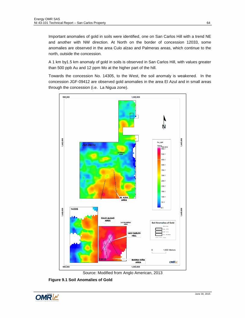
Energy OMR SAS NI 43-101 Technical Report – San Carlos Property 64
June 30, 2015
Important anomalies of gold in soils were identified, one on San Carlos Hill with a trend NE
and another with NW direction. At North on the border of concession 12033, some
anomalies are observed in the area Culo alzao and Palmeras areas, which continue to the
north, outside the concession.
A 1 km by1.5 km anomaly of gold in soils is observed in San Carlos Hill, with values greater
than 500 ppb Au and 12 ppm Mo at the higher part of the hill.
Towards the concession No. 14305, to the West, the soil anomaly is weakened. In the
concession JGF-09412 are observed gold anomalies in the area El Azul and in small areas
through the concession (i.e. La Nigua zone).
Source: Modified from Anglo American, 2013
Figure 9.1 Soil Anomalies of Gold

Energy OMR SAS NI 43-101 Technical Report – San Carlos Property 65
June 30, 2015
9.2.2 Stream Sampling
A campaign of Anglo American includes 34 active stream sediment samples (24 inside the
concessions). The stream sediment sampling results correspond to the areas with soil
anomalies of gold and the artisanal workings, Figure 9.2. Some isolated anomalies of gold
observed in the concessions JGF-09412 and 14305 will require additional exploration
investigations to define their source.
Source: Anglo American, 2013
Figure 9.2 Stream Sampling Results

Energy OMR SAS NI 43-101 Technical Report – San Carlos Property 66
June 30, 2015
9.2.3 Rock Sampling
Anglo American collected 77 chip channel rock samples conducted in mineralized
structures and disseminated mineralization at surface. The sampling included 52 samples
in the concession 12033, 2 samples in the concession 14305, and 8 samples in the
concession JGF-09412.
The results show positive correlations of Au with Te, Ag, Cu, Pb, Zn, Hg y Sb; and of Cu
with Zn, Ag, As, Hg, Pb, Au, Mo y Se; which is concordant with the mineralization, Figures
9.3 and 9.4 show the correlation diagrams constructed with the results of the rock samples
from San Carlos Hill - Buena Seña - Culo Alzao area and El Azul (Mera & Carvajal, 2013).
Source: Anglo American, 2013
Figure 9.3 Correlation Diagram for Rock Samples from San Carlos – Buena Seña – Culo Alzao

Energy OMR SAS NI 43-101 Technical Report – San Carlos Property 67
June 30, 2015
Source: Anglo American, 2013
Figure 9.4 Correlation Diagram for Rock Samples from El Azul.
The map in the Figure 9.5 presents the Au results of the rock samples collected by Anglo
American and Orofino from outcrops and artisanal underground workings. It is observed
the good potential of the areas of San Carlos Hill – Buena Seña - Culo Alzao, and El Azul.
Some isolated mineralized structures were sampled to the NW of El Azul and resulted with
high Au grades (5.75 and 1.61 g/t Au).

Energy OMR SAS NI 43-101 Technical Report – San Carlos Property 68
June 30, 2015
Source: Modified from Anglo American, 2013
Figure 9.5 Rock Sampling Results of the Anglo American and Orofino Campaigns
The location of the artisanal tunnel entrances and the interpretation of the trends of the
mineralized structures based in the investigations performed by Anglo American and

Energy OMR SAS NI 43-101 Technical Report – San Carlos Property 69
June 30, 2015
Orofino, is presented in the Figure 9.6. The areas with more potential for high Au grade
structures are: San Carlos Hill – Buena Seña, Culo Alzao and El Azul area. Other isolated
areas like La Nigua, La Azul, could require more exploration activities to define its potential.
The diverse exploration campaigns of the different companies have been used to locate the
mine entrances of the artisanal underground workings.
Figure 9.6 Artisanal Mines Location and Interpreted High Grade Structure (Vein) Trends in the Property

Energy OMR SAS NI 43-101 Technical Report – San Carlos Property 70
June 30, 2015
San Carlos Hill – Buena Seña Area
The Figure 9.7 presents the results of the rock samples collected in San Carlos hill –
Buena Seña and the interpreted vein trends.
Figure 9.7 Interpreted Vein Trends and Rock Sampling Results in San Carlos Hill – Buena Seña Area.
James, M. (2011) reported sample results from the exploited vein in the San Carlos mine
with 14.86 g/t Au, 14.57 g/t Au and 16.98 g/t Au.
In Mina de Agua mine, one sample collected from the NE vein contains 34.37 g/t Au and
159.0 g/t Ag. Other samples taken in the same vein contains 0.40 g/t Au y 0.5 g/t Ag;
2.918 g/t Au and 23.1 g/t Ag; 0.22 g/t Au y 0.6 g/t Ag and 7.217 g/t

Energy OMR SAS NI 43-101 Technical Report – San Carlos Property 71
June 30, 2015
In Mina Loca mine, samples from a vein with N40°E/75°N, resulted with 11.060 g/t Au
and 18.4 g/t Ag, 0.098 g/t Au and 2.2 g/t Ag and 0.918 g/t Au and 2.6 g/t Ag.
In Mina Loca Baja mine, samples of a vein with N45°E/80°S contain 5.66 g/t Au and 16.8
g/t Ag, 22.93 g/t Au and 1,031.8 g/t Ag, 24.11 g/t Au and 193.3 g/t Ag. The sample of the
mineralized halo in the host rock resulted in 1.55 g/t Au and 29.6 g/t Ag.
In the Aguas Claras mine, located to the NE of the Mina de Agua mine, a sample from a
vein of 25 cm width resulted in 1.038 g/t Au and 3.1 g/t Ag.
Culo Alzao Area
The Figure 9.8 presents the interpreted vein trends and the results of the rock samples
collected at surface to the south of the Culo Alzao area that resulted with low Au grades
with values of Au <0.5 g/t Au. A sample with 1.19 g/t Au was taken from a vein striking
NNW that is correlated with the vein exploited in Los Santos mine, were there are reported
exploited areas with grades greater than 10 g/t Au.
Figure 9.8 Interpreted Veins and Rock Sampling Results in Culo Alzao Area.

Energy OMR SAS NI 43-101 Technical Report – San Carlos Property 72
June 30, 2015
El Azul Area
The Figure 9.9 presents the rock sampling results and the interpreted vein trends in the
area of El Azul.
Figure 9.9 Interpreted Veins and Rock Sampling Results in El Azul Area.
The number of samples is limited and only some veins have been sampled in a not
systematic way. Samples from veins in La Estrella mine and La Estrella-El Azul mine
resulted with values of 2.54 g/t Au and 28.03 g/t Au. An isolated sample taken in a vein to
the SE of the Piña mine contains 3.36 g/t Au.

Energy OMR SAS NI 43-101 Technical Report – San Carlos Property 73
June 30, 2015
10 Drilling (Item 10) From September to November 2013, Anglo American completed two diamond drill holes,
totaling 1,519.5 meters, Table 10.1. The drill holes were collared at the San Carlos Hill in
areas with intensive hydrothermal alteration.
Table 10.1 Exploration Drill Summary
HOLE # EAST (m)
NORTH (m) ELEVATION
(m) AZIMUTH
(°) DIP (°) DEPTH (m)
SAC13DDH001 998,112 1,438,252 272 135 60 768,9
SAC13DDH002 997,971 1,437,954 314 130 60 750,6
Total m drilled 1,519.5
The preferred orientation of drill holes were SE with azimuths between 128° to 135°, and
roughly perpendicular to the strike of the trend of the mineralization. The drill holes were
not planned to appropriately test the high grade structures and were designed to test the
intensive hydrothermal alteration and the textures of a typical porphyry type deposit (Au-Cu)
observed at the higher part of the San Carlos Hill to the north of the area of more intensive
artisanal exploitation activities. Figure 10.1 presents the collars and traces of the two drill
holes.

Energy OMR SAS NI 43-101 Technical Report – San Carlos Property 74
June 30, 2015
Figure 10.1 Collars and Traces of Drill Holes Completed by Anglo American

Energy OMR SAS NI 43-101 Technical Report – San Carlos Property 75
June 30, 2015
The core recovery was not reported, but according to the visual check of the core boxes,
appears to have good average of recovery. All drill holes were started as HQ (63.5 mm
diameter) size core and reduced to NQ (47.6 mm diameter) sized core at about 500 m
depth.
Downhole orientation surveys were conducted using Reflex Multi Shot. A nominal 2.0 m
sample interval was used without considering geological or mineralization changes to
define sample length. Half of whole core was sampled with an electrical saw. The whole
drill hole length were sampled.
Drill core was placed in labelled boxes, fitted with lids and transported to the site logging
facility by pick-up. Core was logged, photographed, and then split using a diamond saw.
Half of the core was stored on site, and the other half was sent to the Acme Lab. The drill
hole collars were marked with cement and metal markers.
The drill collar location was established with a portable GPS and a compass was used to
establish a line along the planned drill azimuth. The drilling and sampling procedures
observed were of high standard and appeared to be diligently implemented.
10.1 Drilling results
Anglo American projected the drill holes to test at depth the porphyry type mineralization of
low grade observed at Surface. The evidences observed at surface, the geochemical
sampling results and magnetic anomaly supported the hypothesis of the possible existence
of high grade porphyry Au ± Cu ± Mo associated to a potassic alteration center.
The drill hole No. SAC13DDH001 was collared to test the soil anomaly higher than 500 ppb
Au and 8 ppm Mo, and the projection to depth of the B and AB veinlets with relicts of
potassic hydrothermal alteration observed at the higher part of the San Carlos Hill. The drill
hole No. SAC13DDH002 was located in an area of strong sericitic hydrothermal alteration
that coincides with the soil anomaly higher than 500 ppb Au and a high magnetic response
(Anglo American, 2014), Figure 10.1.
Drill Hole No. SAC13DDH001
The best results of the drill hole correspond to punctual values of no more than 2 m length
due to the low mineralization characteristic of this system. There are some intercepts of Cu
of 6 m with values of 535 ppm Cu and 504 ppm Cu at 236 and 262 m depth respectively,
and 8 m intercepts with 598 ppm Cu and 10 m with 658 ppm Cu. For Mo, there are
intercepts of 6 m with 101 ppm Mo, 96 ppm Mo and 92 ppm Mo at 154 m, 420 m and 454 m
respectively. The best value of Au is encountered at 470 m with 4 m at 909 ppb Au, with
other intercepts that vary from 4 to 12 m with 157 ppb Au and 184 ppb Au at 92 and 236 m
depth respectively. Locally there are some good values of Silver in intercepts of 2 m
resulting in 3,012 ppb Ag, 31,621 ppb Ag, 4,498 ppb Ag and 5,240 ppb Ag found at 94 m,
526 m, 608 m and 702 m respectively (Anglo American, 2014). Figure 10.2 shows the strip
log with the results of this drill hole.

Energy OMR SAS NI 43-101 Technical Report – San Carlos Property 76
June 30, 2015
Source: Anglo American, 2014
Figure 10.2 Strip Log of Geochemical Results of Au, Mo, Au and Ag. Drill Hole SAC13DDH001.
Drill Hole No. SAC13DDH002
The results of this drill hole have similar behavior to drill hole SAC13DDH001 with values of
Cu varying between 507 ppm Cu and 599 ppm Cu at 234m, 284m, 330m, 382m, 410m,
480m, 550m, 584m, y 678m. The Mo presents an anomalous interval of 10 m with 184 ppm
Mo at 286 m depth and other intervals of 4 m with Mo varying between 117 ppm Mo and
142ppm Mo. The values of gold are low with an intercept of 145 ppb Au in the first 10 m
and locally 135 ppb Au in a 2 m intercept. The maximum value of Ag was 2 m with 1,834
ppb Ag at 40 m depth, Figure 10.3 shows the strip log with the results of this drill hole.

Energy OMR SAS NI 43-101 Technical Report – San Carlos Property 77
June 30, 2015
Source: Anglo American, 2014
Figure 10.3 Strip Log of Geochemical Results of Au, Mo, Au and Ag. Drill Hole SAC13DDH002.

Energy OMR SAS NI 43-101 Technical Report – San Carlos Property 78
June 30, 2015
11 Sample Preparation, Analysis and Security (Item 11) The sample preparation and analytical procedures used for the Joint Venture Sociedad
Kedahda SA & B2Gold Corporation samples were not provided and are not known.
The Anglo American rock and core samples were prepared and analyzed by Acme
Analytical Laboratories, all samples were shipped to ACME Labs in Medellin, an ISO 9001
certified laboratory where sample preparation was performed and then sent for analysis to
Acme Analytical Laboratories, an ISO certified facility in Vancouver, B.C. Anglo American,
(2014).
The sample preparation procedures were as follows: Crush 70% 10 mesh and pulverize
250 g and Pulverize to 85% passing 200 mesh.
ACME Labs in Vancouver analyzed samples for gold and 52 elements by 1:1:1 Aqua Regia
digestion Ultratrace and ICP-MS (Induced Coupled Plasma – Mass Spectrometry)
Instrumentation Method, 52 elements (detection limits 0.2ppb to 100 ppm): prepared
sample is digested with a modified aqua regia solution of equal parts concentrated HCl,
HNO3 and Deionized H2O for one hour in a heating block of hot water bath. Sample is
made up to volume with dilute HCl.
Some pulp samples of drill core (146 samples of 759 samples) were analyzed by Actlabs in
Medellin for gold by Fire Assay (30 g sample) with AA (Atomic Absorption) finish (detection
limits 5 to 5000 ppb).
EOMR was not able to locate a QA/QC protocol report or a quality external audit relating to
the Anglo American samples, required in case of a resource estimation study.
There is evidence on spreadsheets of a regular frequency of insertion of blanks, coarse
duplicates and pulp duplicates and standards on the flow of sampling but control samples
and reference material standard are not identified in order to evaluate the QC program.
However it is known the good practices of this company on its works.
Disposition of rejects and pulps is unknown, but It is suggested try to locate pulps of the
core samples and send them for reanalysis in case of economic intervals, with standard
reference material (SRM) samples inserted for analytical control.
Orofino Gold Corp campaign of rock sampling did not report procedure of sampling or
QA/QC program, but lab certificates were included. Samples were analyzed by inspectorate
Laboratory, in Nevada (USA), for gold by Fire Assay (30g sample) with AA finish (detection
limits 0.005 ppm to 10 ppm), over limit gold values were repeated with Gravimetric finish,
also for Silver by Aqua Regia Trace levels and AA finish and over limit with fire Assay with
Gravimetric Finish.

Energy OMR SAS NI 43-101 Technical Report – San Carlos Property 79
June 30, 2015
12 Data Verification (Item 12) The author verified the data visiting from 6
th to 7
th of March the office of Los Mates in
Medellín, where a coordination of the site visit and the review of the available information
was carried out. From April 14th to 17
th the author visited the Property and went over the
area examining the outcrops along roads and trials, confirming geological setting, visiting
many artisanal tunnels and process plants and taking samples from typical mineralized
rocks. The areas visited included the San Carlos Hill, Buena Seña, Culo Alzao, and El
Azul.
In May 4th, the author visited the core shack of Anglo American in Bogotá, where the core of
the two drill holes completed in the San Carlos hill was examined.
12.1 Procedures
Five independent chip channel rock samples were collected from different areas of the
Property:
San Carlos Hill:
- 2 samples were taken from the la Cruzada-El Burro tunnel, one from a high grade
structure and other from the disseminated mineralization
- 1 sample from the La Puente tunnel
Culo Alzao:
- 1 sample from the high grade vein in Mina Oscar;
- 1 sample from the high grade vein in the Garavito 1 tunnel
The samples were bagged, tagged and sealed in plastic bags and remained in possession
of the author for the trip from the Property to Bucaramanga. The author sent the samples
to ALS labs in Medellín. The samples that weighted from 4 to 7 kilograms were prepared
(crushed, split, pulverized, dried), and then shipped to the ALS lab in Lima for analysis.
The chemical analysis consisted multiple element ICP analysis (35 element aqua regia ICP-
AES; code: ME-ICP41), and Fire Assay of gold (Au 30 g FA-AA, code: Au-AA23). The
samples containing more than 10 g/t Au, were analyzed by Au 30 g Fire Assay –
gravimetric finish (Code:Au-GRA21) and Ore grade Ag – four acid / AAS (Code: Ag-AA62).
Two control samples were included. Table 12.1 presents the results of the independent
samples. The assay certificates and results for the samples can be found in Appendix A.

Energy OMR SAS NI 43-101 Technical Report – San Carlos Property 80
June 30, 2015
Table 12.1 List of independent samples and results – San Carlos project site visit, April 2015
Location Tunnel Name Sample type Sample ID Au
(ppm) Ag
(ppm) Cu (%)
San Carlos Hill La Cruzada-El Burro Chip channel GO-SC0001 52.3 316 0.02
San Carlos Hill La Cruzada-El Burro Chip channel GO-SC0002 0.03 0.2 0.001
San Carlos Hill La Puente tunnel Chip channel GO-SC0004 1.72 3.8 0.01
Culo Alzao Mina Oscar Chip channel GO-SC0006 1.13 10.9 0.01
Culo Alzao Garavito 1 Chip channel GO-SC0007 2.05 14.4 0.02
For the drill data, assay interval data were confirmed using the drill logs excel
spreadsheets, and the assay values were validated using the laboratory certificates. A
check was also done comparing the lithological logging to the core photos.
No errors were found in the database for these holes. The author did not review the data
handling procedures, as that information was not available.
Some additional checks were run of the database to determine non – assayed / logged
intervals, sample overlaps, missing collar information, and incorrect total hole depths. A
small number of errors were referred to Los Mates for correction prior to the issue of the
final database.
Original drill logs, survey worksheets and other original data were not located in order to
verify the data contained in the excel spreadsheets. By the other side, assay certificates
were available and used to verify the data. Results below detection were entered in the
database as half of the limit value.

Energy OMR SAS NI 43-101 Technical Report – San Carlos Property 81
June 30, 2015
13 Mineral Processing and Metallurgical Testing To date, no mineral processing and metallurgical studies have been carried out on San
Carlos Property mineralization.

Energy OMR SAS NI 43-101 Technical Report – San Carlos Property 82
June 30, 2015
14 Mineral Resource Estimate (Item 14) To date, no NI 43 -101 compliant mineral resource estimates has been completed on the
San Carlos Property.

Energy OMR SAS NI 43-101 Technical Report – San Carlos Property 83
June 30, 2015
15 Mineral Reserve Estimates (Item 15) To date, no NI 43 -101 compliant mineral reserve estimates has been completed on the
San Carlos Property.

Energy OMR SAS NI 43-101 Technical Report – San Carlos Property 84
June 30, 2015
16 Mining Methods (Item 16) To date, no studies of mining methods have been carried out on the San Carlos Property.

Energy OMR SAS NI 43-101 Technical Report – San Carlos Property 85
June 30, 2015
17 Recovery Methods (Item 17) To date, no studies of recovery methods have been carried out on the San Carlos Property,
as no processing or metallurgical investigations have been completed on the Property
mineral.
Energy OMR SAS NI 43-101 Technical Report – San Carlos Property 86
June 30, 2015
18 Project Infrastructure (Item 18) To date, studies of required infrastructure for a potential mine project have not been carried
out for the San Carlos Property. Exploitation permits for the concession contracts 12033
and 14305 were issued in accordance with Colombian mining laws for small scale mining
operations. Further work needs to be done to meet the higher NI 43-101 standards.

Energy OMR SAS NI 43-101 Technical Report – San Carlos Property 87
June 30, 2015
19 Market Studies and Contracts (Item 19) To date, there are not market studies or contracts associated to the mineralization within
the San Carlos Property completed by 8768820 Canada Inc.

Energy OMR SAS NI 43-101 Technical Report – San Carlos Property 88
June 30, 2015
20 Environmental Studies, Permitting and Social or Community Impact (Item 20) In 2005, the previous titleholder of the concession contracts associated to the Property,
developed environmental studies and obtained environmental License for two small mining
operations in the concession contracts 14305 and 12033.
For the Concession Contract No. 14305, the Corporación Autónoma Regional del Sur de
Bolivar (CSB) approved the environmental management plan and granted the
environmental license through Resolution 576 of May 6, 2005.
For the Concession Contract No. 12033, The CSB approved the environmental
management plan and granted the environmental license through Resolution 575 of May 6,
2005.
These licenses are in process to be transferred to Los Mates from the previous titleholder.
Additional environmental base line and environmental impact assessments for a modern
exploitation project of medium/large scale have not been performed on the San Carlos
Property.
At present, community impact is minimal as there is not exploration or exploitation activities
in process, and the labor force in the Property are conducting the artisanal exploitations. A
community relations program is necessary to manage the community impacts and related
factors.
For the recommended exploration work is necessary to obtain or extend the coverage of
permits for water use, management of dangerous residues, discharges and sewage. The
company should inform to the CSB, the exploration activities to be executed that should
fulfill the Mining and Environmental Guides for exploration (Guías Minero Ambientales de
Exploración) produced by the Ministry of Mines and the Ministry of Environment. The
regional environmental Corporation, CSB, is the competent corporation to oversee the
exploration activities in the Property.
Although is not an issue now, at some point in the future, 8768820 Canada Inc. may require
the relocation of some houses and people if a large/medium scale mine operations is
defined.
20.1 Not authorized mining
In the areas of San Carlos Hill - Buena Seña, Culo Alzao and El Azul, there are many not
authorized mining. These activities are being carried out by locals using artisanal methods
of exploitation and processing (Use of mercury) without environmental, technical and safety
controls, Figures 20.1 and 20.2.

Energy OMR SAS NI 43-101 Technical Report – San Carlos Property 89
June 30, 2015
Figure 20.1 Artisanal Process Plant in El Azul.
These activities are generating environmental impacts that have not been evaluated. The
future environmental base line studies should address this problematic and formulate an
action plan to mitigate the impacts.
The management of Los Mates has initiated the approaching to the Ministry of Mines of
Colombia to start exploring the awarding of subcontracts of mining formalization with the
artisanal miners. These subcontracts allow the titleholder to transfer the obligations and
responsibilities of the mining activities to the small miners but not include the transfer of
rights over the mining title that is fully conserved by the company. The small miners should
accomplish the technical, environmental and safety obligations in their operations and will
be directly audited by the Colombian National Agency of Mining (Agencia Nacional de
Minería).

Energy OMR SAS NI 43-101 Technical Report – San Carlos Property 90
June 30, 2015
Figure 20.2 Access Shaft of an Artisanal Mine in El Azul.

Energy OMR SAS NI 43-101 Technical Report – San Carlos Property 91
June 30, 2015
21 Capital and Operating Costs (Item 21) To date, no capital and operating costs have been evaluated for a mining project in the San
Carlos Property.

Energy OMR SAS NI 43-101 Technical Report – San Carlos Property 92
June 30, 2015
22 Economic Analysis (Item 22) To date, no economic analysis has been completed for a mining operation in the San
Carlos Property.

Energy OMR SAS NI 43-101 Technical Report – San Carlos Property 93
June 30, 2015
23 Adjacent Properties (Item 23) The Figure 23.1 outlines the San Carlos Property and the adjacent mining titles. The areas
without polygons correspond to concession contract applications that are in process of
granting in the National Agency of Mining.
To the knowledge of the author and of the Los Mates management, there are no publicity
reported occurrences of significant gold mineralization within the nearest adjacent
properties to the San Carlos Property. To the knowledge of the author of the Los Mates
management no exploration drilling or substantial works have been carried out within the
adjacent properties.
In the vicinity of the Property there are artisanal mines in different places around the
Property, and some of them have been mentioned in this report. There are some
mineralized structures that, according to the existing artisanal workings, clearly continue
outside of the Property as happens in the areas of Culo Alzao and Las Palmeras.
If meaningful mineralization must be disclosed on adjacent properties, not necessarily
indicates the existence of mineralization at the San Carlos Property. The mineralization
reported in this document is particular within the concessions of the San Carlos Property.

Energy OMR SAS NI 43-101 Technical Report – San Carlos Property 94
June 30, 2015
Source: Colombian National Agency of Mining, 2015
Figure 23.1 Location of the Properties Adjacent to San Carlos Property

Energy OMR SAS NI 43-101 Technical Report – San Carlos Property 95
June 30, 2015
24 Other Relevant Data and Information (Item 24) The San Carlos project is located in a region where the presence of insurgency groups like
ELN (Ejercito de Liberación Nacional) and FARC (Fuerzas Armadas Revolucionarias de
Colombia) have been affecting negatively the security the region of San Lucas. In the last 5
years there has been no appearance of these insurgency groups in the property due to the
continuous patrolling of the Colombian army.
Since the last decade, the government of Colombia has made important efforts to improve
the security in the region and the country, improving training and equipment of the army
and increasing the presence of the forces of the state in the region and thorough the
country.
Colombian president, Juan Manuel Santos, 2010 – present, initiated in August 27, 2010,
the peaceful negotiations with the Revolutionary Armed Forces of Colombia (FARC) and
lately have started approaches with the National Liberation Army (ELN). His reelection in
2014 was considered a support of the population to his efforts to conclude the peace
agreements and finalize the longstanding civil war. For now, the peaceful negotiations
continue and there is not a defined date to finish them.
Around the country, the Colombian army continues its pressure and military operations
against guerrillas.
Although the presence of the insurgent groups is not the regular situation in the area of the
project, the company has to implement, as a precautionary measure, a comprehensive
security program to reduce security risk and pro-actively assure the safety of people
working in the exploration campaigns. In the recent past, AngloGold Ashanti, B2Gold and
Anglo American have demonstrated that the implementation of a comprehensive security
program in a close coordination with the Colombian army is the way to manage the safety
in the Property.

Energy OMR SAS NI 43-101 Technical Report – San Carlos Property 96
June 30, 2015
25 Interpretation and Conclusions (Item 25) The concessions 14305 and 12033 are in the exploitation phase with environmental, water
and minor permits approved for small exploitation operations that included a
resource/reserve estimate issued according to the Colombian mining law. However, NI 43-
101 standards are higher, therefore using NI rules; further work needs to be done to meet
the higher Ni 43-101 standards.
On February 24th 2014, the concession contract JGF-09412 entered in the construction and
assemblage phase for a small scale exploitation operation.
The San Carlos Property is located within the historically important and present-day
artisanal mining district of the Serranía de San Lucas. In the San Carlos Hill, the
mineralization is related to high-level hypabyssal Au (Cu) porphyry bodies. The
disseminated mineralization of low grade of gold is observed in outcrops and drill holes
completed by Anglo American in 2013, where is clear the hydrothermal alteration zonation
characteristic of a porphyry type deposit. High gold grade veins in Culo Alzao and El Azul
and in some veins in San Carlos Hill can be associated to intrusion-related mesothermal
gold veins. These gold veins have been exploited for decades and their mining potential
has not been studied appropriately.
Although the exploration information has been generated by recognized companies and
authors of the industry, there is not complete documentation of all exploration workings
carried out previously that can be used in future mineral resource estimation. This
introduces some grade of uncertainty in the interpretations included in this report.
The exploration carried out previously by Anglo American and Joint Venture Sociedad
Kedahda-B2Gold were focused in the discovery of a possible substantial tonnage porphyry
type gold – copper deposit at the San Carlos Hill and not in the definition of the high gold
grade veins potential.
Based on the available information, the areas with more potential to host economic high
gold grade mineralization in veins in the Property are: San Carlos Hill – Buena Seña, Culo
Alzao and El Azul. The main structural controls of the veins in San Carlos Hill have two
main directions, N50°-60°E and N20°-N45°E and dipping mostly from 70° to 90° to SE. The
width of the veins varies from decimeters to locally 2 m thickness. In Culo Alzao, the
control varies from NS to N20°W and dipping from 70 to 90°. In El Azul, the trends are
varying from NS to N20°E. In these two locations, the width of the veins varies from 0.15 to
1 m thickness.
Based on the location of the artisanal underground workings the mineralized structures can
be traced discontinuously from few hundreds of meters to close to 1.2 km. According to the
artisanal miners, the veins at San Carlos Hill have been worked to depths of up to 80 m,
and the elevation differences between workings are close to 200 m. In Culo Alzao, the
workings reach 30-40 m depth. In El Azul, the depth of the workings goes up to 50 m. In

Energy OMR SAS NI 43-101 Technical Report – San Carlos Property 97
June 30, 2015
the district of Serranía de San Lucas there are reports of vertical continuities of the veins of
500 m (Smith - Gorham, 2012).
The mineralization in veins and veinlet systems at San Carlos Hill – Buena Seña is
characterized predominantly by quartz – pyrite and minor chalcopyrite–galena-sphalerite,
and associated low gold grade mineralization in the altered host rocks. In Culo Alzao and
El Azul the mineralization is distinguished by quartz (Calcedony in El Azul)–pyrite–galena–
sphalerite–chalcopyrite. In El Azul, the alteration in the host rock (gneiss) extends few
centimeters close to the veins. In Culo Alzao, the alteration in the host rock is typically
sericitic in halos of meters in the gneiss. The gold grades in the veins are variable, with
values varying from 0.2 – 0.7 g/t Au in bodies with intense veining and in veins from less
than 1 g/t Au up to 100 g/t Au in veins at the San Carlos Hill – Buena Seña area. In Culo
Alzao and El Azul the sampling has resulted in values of up to 30 – 40 g/t Au.
The characteristics of the veins that have been exploited for years thorough the Property,
and the results of the previous exploration campaigns show an excellent potential to host
significant high gold-silver grade mineralization in the San Carlos Property and warrants a
systematic exploration effort.
The disseminated mineralization of gold in the San Carlos Hill has been tested at surface
and in drill holes and the results showed contents of gold typically less than 0.3 g/t Au.
Although the results are not positive, there is some potential for porphyry mineralization in
other areas of the property.
There is not information about the QA/QC program and procedures used during the
geochemical sampling campaigns carried out before the date of this document. The author
recommends generating procedures and the design of a comprehensive QA/QC program
for all the future exploration activities to collect new data and to define the potential of the
veins through the Property.
The geological mapping and geochemical programs undertaken to date at the property are
not sufficient to begin drilling, further such programs are required to prepare property for
compliant drilling procedures.
The future exploration program requires the definition of a community relations strategy to
improve the interaction of the company with the population settled in the prospective areas.
The existence of not authorized artisanal exploitations in the Property is an issue that needs
to be addressed properly with social programs.
As a precautionary measure, the implementation of a comprehensive security program will
reduce security risk further and pro-actively assure the safety of people working on the
property.

Energy OMR SAS NI 43-101 Technical Report – San Carlos Property 98
June 30, 2015
26 Recommendations (Item 26)
26.1 Recommended work program
The explorations carried out in the Property and the multiple artisanal mining through the
Property demonstrate the important potential of the Property to host considerable resources
of gold and silver associated to the high grade structures (veins) identified in the area.
An additional amount of exploration activities will be needed to characterize appropriately
the mineralization in the areas of San Carlos hill-Buena Seña, Culo Alzao and El Azul, due
to the extension of the mineralized structures and the intrinsic high variability that typify the
mineralization. Prior to the initiation of the exploration activities it is necessary to define the
protocols for all the exploration activities and a comprehensive QA/QC program.
Before definition of new drill targets, a considerable exploration campaign will be required to
define the targets and the priorities based on a detailed geological mapping of the
mineralized structures and regional exploration. As such, a two phase program is
recommended in order to obtain the required information to advance in the definition of the
potential for gold of the Property.
Phase I. Detailed geological mapping and regional exploration.
Phase II. First-round Drilling.
The phase I is anticipated to take 4 to 5 months to complete. The phase 2 may take 3 to 4
months using 2 drill rigs. A total estimated budget of US$2.8 million composed by
US$0.58 million for the Phase I, US$1.98 million for Phase II and US$0.25 million for
contingencies (Table 26.1).
The results of the two phases will be used to define a drilling program required to collect the
data to perform the first inferred resources estimate. The density of drilling, holes depth,
holes aptitude and quantity of drilling will depend of the size of the mineral deposit, the
geometry and the characteristics of the mineralization.
26.1.1 Phase I. Detailed geological mapping and regional exploration
In order to obtain information to make exploration decisions and about what to prioritize for
future works, it is necessary to collect high-quality geological information of the already
defined target areas and from the rest of the Property.
The first tasks to be performed are the standardization of all exploration activities producing
applicable procedures, and the design of a proper QA/QC program to guarantee the quality
and adequate credibility in the data for geological interpretations and decision taking.
These tasks have to accomplish the best practices of the industry including a suitable
documentation.
The following are the objectives of the phase I:

Energy OMR SAS NI 43-101 Technical Report – San Carlos Property 99
June 30, 2015
- Characterize the high gold grade mineralization in structures.
- Locate with precision the mineralized structures and define their horizontal
continuity at surface.
- Sample the structures at surface, in underground workings and in trenches.
- Define the areas with the best mineral potential and establish exploration priorities
of drill-ready structures.
- Determine other exploration targets in the Property.
- Design a drilling program to test the down dip extension of the mineralized
structures.
The activities included in the phase I, include:
- Surveying of the outcrops and underground workings where samples are collected.
- Detailed geological mapping and sampling of outcrops and existing underground
workings, including description and collection of geological data.
- Construction of trenches and rock sampling to test the horizontal continuity of the
mineralized structures and definition of the traces of them.
- Develop close grid soil sampling to verify anomalies previously defined in other
exploration campaigns.
- The regional exploration includes geological recognition, mapping and geochemical
sampling (active sediments, soils, rocks) and application of geophysical methods of
exploration. These investigations should be based in a previous orientation study.
This work will provide favorable, but not yet drill-ready.
The Table 26.1 presents the estimated costs of the activities of the Phase I of the
recommended exploration program.
26.1.2 Phase II. First-round drilling
Based on the results of the phase I, drill targets should be defined to test the down dip
extension of the mineralization observed at surface and within underground workings. The
location of the drill holes, their direction and inclination will be defined in places with the
best mineral potential defined in the Phase I as drill-ready structures.
The main objective is to test the prolongation of the gold mineralization to depth, targeting
the interception of the mineralized structures, group of structures or lodes, at relative
shallow depths below or between the locations where the structures were sampled at
surface and within underground workings. One of the results of the drilling is the correlation
between the results from drill hole intercepts and the samples from mine and exploration
workings.

Energy OMR SAS NI 43-101 Technical Report – San Carlos Property 100
June 30, 2015
As this is not a drill program to define resources, the drill spacing cannot be established and
depends on the location of the mining and exploration workings. 5,000 m of drilling are
considered adequate to test the mineralization in the Property in the first round.
It is recommended that the company contemplates the execution of preliminary
metallurgical testing to have information of the potential metallurgical recovery of gold.
The Table 26.1 presents the estimated costs of the activities of the Phase II of the
recommended exploration program.
26.2 Costs
The Table 26.1 presents the estimated budget for the recommended works
Table 26.1 Budget for Recommended Exploration Work on San Carlos Property
Item Cost US$ 000's
Phase I
Personnel (Geologists, Auxiliary) 350
Camp, supplies, services 85
Laboratory analysis 55
Access permitting 10
Security – Social 20
Transportation 15
Administrative Costs 25
Materials 15
Sub-Total Phase I 575
Phase II
Personnel (Geologists, Auxiliary) 350
Camp, supplies, services 235
Drilling (5,000 m) 770
Trenches and other exploration activities 45
Laboratory analysis 410
Access permitting 35
Security – Social 20
Environmental studies 20
Transportation 20
Metallurgy 25
Administrative costs 50
Sub-Total Phase II 1,980
Sub-Total Phases I and II 2,555
Contingency (10%) 256
Total US$000’s 2,811
Energy OMR SAS NI 43-101 Technical Report – San Carlos Property 101
June 30, 2015
27 References (Item 27) Anglo American Colombia Exploration S.A. (2014). San Carlos, Drilling Report,
Concession Contract No. 12033, pp. 4-24.
Arango, L.F. (2014). Review of Background of the Mining Title No. 14305, pp. 1-5.
Arango, L.F. (2014). Review of Background of the Mining Title No. JGF-09412, pp. 1-4.
Arango, L.F. (2014). Review of Background of the Mining Title No. 12033, pp. 1-6.
Bogotá, J. and Aluja, J. (1981). Geology of the Serranía de San Lucas, Geología
Norandina, pp. 49-56.
Camacho G., J.A. (2011). Diagnostic of Mining Potential of Licences 12033, 14305 and
JGF-09412, South of Bolivar, San Carlos Project, pp. 14-22, 28-31.
Clavijo, J. (1996). Geology Map of Colombia, Topographic Plate No. 75 – Aguachica,
Explanatory Report: Ingeominas, pp. 1-48.
Galvis V., J. and De La Espriella, R. (1990). Precious Metals Manifestations in the Area of
the Morales-El Banco Project in the Northeast Region of the Serranía de San Lucas,
Department of Bolivar, pp. 6-16.
Gobernación de Bolivar (2010). Censo Minero – Sur de Bolivar,
JAMES, M. and Pernett, A. (2011). Geological Progress Report on Mina Azul and Culo
Alzao Areas in the Senderos de Oro Project in Southern Bolivar, Colombia, pp. 1-16.
James, M. (2011). Geologic Progress Report on Au Potential in Permit 12033, Southern
Bolivar Department, Colombia: Orofino Gold, pp. 1-14.
Leal-Mejía, H. (1994). Phanerozoic Gold Metallogeny in the Colombian Andes: A
Tectnono-Magmatic Approach, p. 313 - 329.
LACC Minerals Colombia (2014). Report on The Gold Concessions (JGF-09412 / 14305 /
12033) of Los Mates SAS, pp. 1 – 26.
Mera, M. and Carvajal, D. (2013). Geologícal Mapping of Hydrothermal Alteration Scale
1:10000 and Geochemical Sampling San Carlos – Mina Azul Prospects, Department of
Bolivar: Anglo American Colombia Exploration S.A., pp. 5-31.
O’Dowd, P. (2011). NI43-101 Technical Report The Mejía Concession, Department of
Bolivar, Colombia, pp. 18-19.
Ordoñez C., O., Abad P., A.M. and Tabares, L.F. (2005). Geological and Structural
Cartography of the neighboring of the La Gloria mine, municipality of Barranco de Loba,
Bolivar: Grifos S.A., pp. 1-22.
Rodriguez R., I. (2014). South of Bolivar Project, Due Diligence: Yacimientos de Los Andes
Ltda, pp. 4-38.

Energy OMR SAS NI 43-101 Technical Report – San Carlos Property 102
June 30, 2015
Smith, D. and Gorham, J. (2012). Technical Report on The Snow Mine Property,
Department of Bolivar, Colombia., pp. 33 - 37.
Sociedad Kedahda S.A. (2005). Executive Report, Geology and Geochemistry of San
Lucas Project, pp 1-16.
Suarez, B. (2007). Final Report of Avasca – San Carlos – Buena Seña Project : Joint
Venture Sociedad Kedahda SA & B2Gold Corporation, pp. 1-17.
Energy OMR SAS NI 43-101 Technical Report – San Carlos Property 103
June 30, 2015
Appendices

Energy OMR SAS NI 43-101 Technical Report – San Carlos Property 104
June 30, 2015
Appendix A: Assay Certificates of Independent Samples

Energy OMR SAS NI 43-101 Technical Report – San Carlos Property 105
June 30, 2015

Energy OMR SAS NI 43-101 Technical Report – San Carlos Property 106
June 30, 2015

Energy OMR SAS NI 43-101 Technical Report – San Carlos Property 107
June 30, 2015

Energy OMR SAS NI 43-101 Technical Report – San Carlos Property 108
June 30, 2015

Energy OMR SAS NI 43-101 Technical Report – San Carlos Property 109
June 30, 2015

Energy OMR SAS NI 43-101 Technical Report – San Carlos Property 110
June 30, 2015

Energy OMR SAS NI 43-101 Technical Report – San Carlos Property 111
June 30, 2015

Energy OMR SAS NI 43-101 Technical Report – San Carlos Property 112
June 30, 2015

Energy OMR SAS NI 43-101 Technical Report – San Carlos Property 113
June 30, 2015
Appendix B: Certificate of Qualified Person

Energy OMR SAS NI 43-101 Technical Report – San Carlos Property 114
June 30, 2015
CERTIFICATE OF QUALIFIED PERSON
I, Giovanny Jesús Ortiz Ramos, of Carrera 8 # 10-78 Local 2, Floridablanca, Santander, Colombia,
hereby certify that:
o I am currently employed as Chief Operating Officer by Energy OMR SAS, Carrera 8 # 10-78
Local 2, Floridablanca, Santander, Colombia.
o This certificate applies to the Technical Report titled “NI 43-101 Technical Report San Carlos
Property, Río Viejo, Norosí, and San Martín de Loba Municipalities, Bolivar, Colombia” with
an effective date of June 20, 2015 (the “Technical Report”)
o I am a Professional Geoscientist with the following academic qualifications:
B.Sc. (Geology) Universidad Industrial de Santander, Bucaramanga,
Colombia (1994)
Specialization (Management) Universidad Autónoma de Bucaramanga, Bucaramanga,
Colombia (1994)
I am a registered Geologist with the Colombian Council of Geology, Bogotá, Colombia and a
fellow in good standing of the Australasian Institute of Mining and Metallurgy (AusIMM
304612)
I am familiar with the NI 43-101 and certify that by reason of education, affiliation with a
professional association and past relevant work experience, I fulfill the requirements to be a
“Qualified Person” as defined in NI43-101. My work experience includes 18 years in Andean
deposits as exploration geologist, project manager and VP Exploration, and working in
different terrains.
I am jointly responsible for Sections 1 to 27 of this Technical Report
I made a personal inspection of the San Carlos Property on April 14-17, for 4 days.
I have no previous involvement with San Carlos Property.
I am independent of the issuer applying all of the tests in section 1.5 of NI 43-101.
I have read NI 43-101 and this report has been prepared in compliance with this instrument
and form.
Dated this 30th Day of June, 2015
“signed” _______________________________ Giovanny Jesús Ortiz Ramos, FAusIMM