Embed Size (px)
Citation preview

NI 43-101 Technical Report Dajin Resources (US) Corp. Alkali Lake Project, Esmeralda County, Nevada Vancouver, BC, Canada Brian T. Brewer, CPG, QP 12 December, 2015
NI 43-101 Technical Report Alkali Lake Project, Esmeralda County, Nevada
Prepared For: Dajin Resources (US) Corp.
450-789 West Pender Street Vancouver, BC, Canada V6C 1H2
Location: Sections 3,4,7,8,9,10,16,17,18, 19 and 20, Township 21 South, Range 41 East, Mount Diablo Meridian, Esmeralda County, Nevada.
This report was prepared by the following Qualified Person:
Brian T. Brewer, CPG, QP Salmon, Idaho, USA
Effective Date: 12 December, 2015

NI 43-101 Technical Report Dajin Resources (US) Corp. Alkali Lake Project, Esmeralda County, Nevada Vancouver, BC, Canada Brian T. Brewer, CPG, QP 12 December, 2015
2
IMPORTANT NOTICE
This report was prepared as a National Instrument 43-101 Technical Report, in accordance with Form 43-101F1, for Dajin Resources (US) Corp. (Dajin), by Brian T. Brewer, CPG, QP. The quality of information, conclusions, and estimates contained herein is consistent with: i) information available at the time of preparation, ii) data supplied by outside sources, and iii) the assumptions, conditions, and qualifications set forth in this report. This report is intended for use by Dajin and is approved for filing as a Technical Report with Canadian Securities Regulators. Except for the purposes legislated under provincial securities law, any use of this report by any third party is at that party’s sole risk.

NI 43-101 Technical Report Dajin Resources (US) Corp. Alkali Lake Project, Esmeralda County, Nevada Vancouver, BC, Canada Brian T. Brewer, CPG, QP 12 December, 2015
3
Certificate of Qualified Person
I, Brian T. Brewer, am a professional geologist and am currently working as a consulting geologist residing in Salmon, Idaho.
This certificate applies to the technical report titled “NI-43-101 Technical Report, Alkali Lake Project, Esmeralda County, Nevada”, dated 12 December 2015.
I am a certified professional geologist with the American Institute of Professional Geologists, registry number 11508. I graduated with Bachelor of Science degree in Geology from the University of Idaho, Moscow, Idaho in 1993.
I have approximately 22 years of geologic experience focused in base and precious metals exploration.
I have reviewed the available data and been on the ground at the Alkali Like Project site, as well as having previous geologic knowledge of the area.
As a result of my experience and qualifications, I am a Qualified Person as defined in National Instrument 43-101 Standards of Disclosure of Mineral Projects (NI 43-101).
I have read National Instrument 43-101 and this report has been prepared in compliance with that instrument.
As of the date of this certificate, to the best of my knowledge and information, this report contains all scientific and technical information that is required to be disclosed to make the technical report not misleading.
Signed and Sealed
Brian T. Brewer, CPG, QP.
Dated: 12 December 2015

4
NI 43-101 Technical Report Alkali Lake Project, Esmeralda County, Nevada Brian T. Brewer, CPG, QP
Table of Contents 1.0 Summary .................................................................................
Dajin Resources (US) Corp. Vancouver, BC, Canada
12 December, 2015
.........................7
1.1 Introduction ....................................................................... …………………7
1.2 Property Location and History ........................................... …………………7
1.3 Geology and Mineralization ............................................... …………………7
1.4 Exploration ........................................................................ …………………8
1.5 Drilling ............................................................................... …………………8
1.6 Sample Preparation, Analysis and Security ...................... …………………8
1.7 Data Verification ................................................................ …………………8
1.8 Mineral Processing and Metallurgical Testing ................... …………………8
1.9 Mineral Resource Estimate ............................................... …………………8
1.10 Conclusions and Recommendations ................................. …………………9
2.0 Introduction ....................................................................................... …………………9
2.1 Purpose and Terms of Reference ..................................... …………………10
2.2 Sources of Information ...................................................... …………………10
2.3 Qualified Persons .............................................................. …………………10
2.4 Effective Date ................................................................... …………………10
2.5 Field Involvement of Qualified Persons ............................. …………………10
2.6 Contributors ...................................................................... …………………10
2.7 Units of Measure .............................................................. …………………10
2.7.1 Common Units ...................................................... …………………10
2.7.2 Metric Conversion Factors ..................................... …………………11
2.7.3 Abbreviations ………………………………………… ……………….11
3.0 Reliance on Other Experts .............................................................. ………………...12
4.0 Property Description and Location ........................................... ………………...12
4.1 Location ........................................................................... …………………12
4.2 Located Mineral Claims ..................................................... …………………15
4.3 Property Agreements and Royalties ................................. …………………23
4.4 Environmental Liability ...................................................... …………………23
4.5 Operational Permits and Jurisdictions ............................... …………………23
4.6 Requirements to Maintain the Claims in Good Standing …………………23
4.7 Significant Risk Factors ..................................................... …………………23
5.0 Accessibility, Climate, Local Resources, Infrastructure and Physiography .... 23
5.1 Accessibility .............................................................................................. 23
5.2 Climate and Physiography ........................................................................ 24
5.3 Local Resources and Infrastructure ........................................................... 25
6.0 History ......................................................................................................... 25
6.1 History of Clayton Valley (Spanjers, 2015)................................................ 25
7.0 Geological Setting and Mineralization ............................................................ 27

5
NI 43-101 Technical Report Dajin Resources (US) Corp. Alkali Lake Project, Esmeralda County, Nevada Vancouver, BC, Canada Brian T. Brewer, CPG, QP 12 December, 2015
7. 1 Regional Geology ............................................................................. …… 27 7.2 Property Geology .................................................................................................... 27
7. 3 Mineralization............................................................................................ 27
7.4 Alteration .................................................................................................. 28
8.0 Deposit Type ............................................................................................................... 28
9.0 Exploration .................................................................................................... 28 9.1 Surface Sampling ......................................................................................... 28
9..2 Geophysical Surveys. .................................................................................... 29
10.0 Drilling …………………………………………………………………………….. 34
11.0 Sample Preparation, Analysis and Security .................................................... 34
12.0 Data Verification ........................................................................................ 34
13.0 Adjacent Properties ...................................................................................... 34
14.0 Other Relevant Data and Information .................................................................... 34
15.0 Interpretation and Conclusions ........................................................................ 34
16.0 Recommendations .................................................................................... 35
17.0 References ......................................................................................................... 35
18.0 Date and Signature Page ................................................................................. 36
6
NI 43-101 Technical Report Dajin Resources (US) Corp. Alkali Lake Project, Esmeralda County, Nevada Vancouver, BC, Canada Brian T. Brewer, CPG, QP 12 December, 2015
LIST OF FIGURES
Figure 1: Alkali Lake Property Location Map ............................................................ 13 Figure 2: Alkali Lake Property Location on USGS Orthophoto ..................................... 14 Figure 3: Alkali lake Property Location ..................................................................... 15 Figure 4: Dajin’s Alkali Lake Claim Blocks… ..................................................... …. 22 Figure 5: Alkali Lake Area Looking North………….…………………………………………….25 Figure 6: Regional Geology Map of Stewart and Carlson (1978) ……………………………. 27 Figure 7: Gravity Station Plots and Basin Model Overlain on Geology….…………………… 30 Figure 8: Interpreted Structures and Basin Model Over Geology………………………………31 Figure 9: Basin Model and Drainage Courses Over 1:500,000 Geology………………………32 Figure 10: Overview of Alkali Lake Gravity Model…………………………………………………33
LIST OF TABLES
Table 1: List of Active (registered) Alkali Lake PropertyClaims ......................... 16, 17 &18 Table 2: List of Pending Alkali Lake Property Claims ................................ 19, 20 & 21 Table 3: Auger Samples ......................................................................................... 29 Table 4: Grab Samples ............................................................................................ 29

NI 43-101 Technical Report Dajin Resources (US) Corp. Alkali Lake Project, Esmeralda County, Nevada Vancouver, BC, Canada Brian T. Brewer, CPG, QP 12 December, 2015
7
1.0 SUMMARY
1.1 Introduction
The Alkali Lake Project is a grass roots stage lithium property consisting of one hundred seven (107) unpatented placer claims covering approximately 2,760 acres. These claims were staked and are currently held in good standing by Dajin Resources (US) Corporation, a wholly owned subsidiary of Dajin Resources Corporation.
Dajin Resources Corp. is a publically traded lithium exploration company listed on the TSX Venture Exchange under the symbol DJI (TSXV:DJI). Dajin’s corporate office is located at 450-789 West Pender Street, Vancouver, British Colombia, Canada.
Brian T. Brewer, C.P.G., was retained to prepare a technical report on the early-stage exploration activities on the Alkali Lake Property. The purpose of this report is to provide the reader with a comprehensive review of the past exploration activities conducted on the Alkali Lake Project and the viability of this property as a Property of Merit for continued exploration efforts. This report is not intended to define any economic conclusions upon which to make a development decision for the project. This report is intended to comply with the requirements of National Instrument 43-101 (NI 43-101).
1.2 Property Location and History
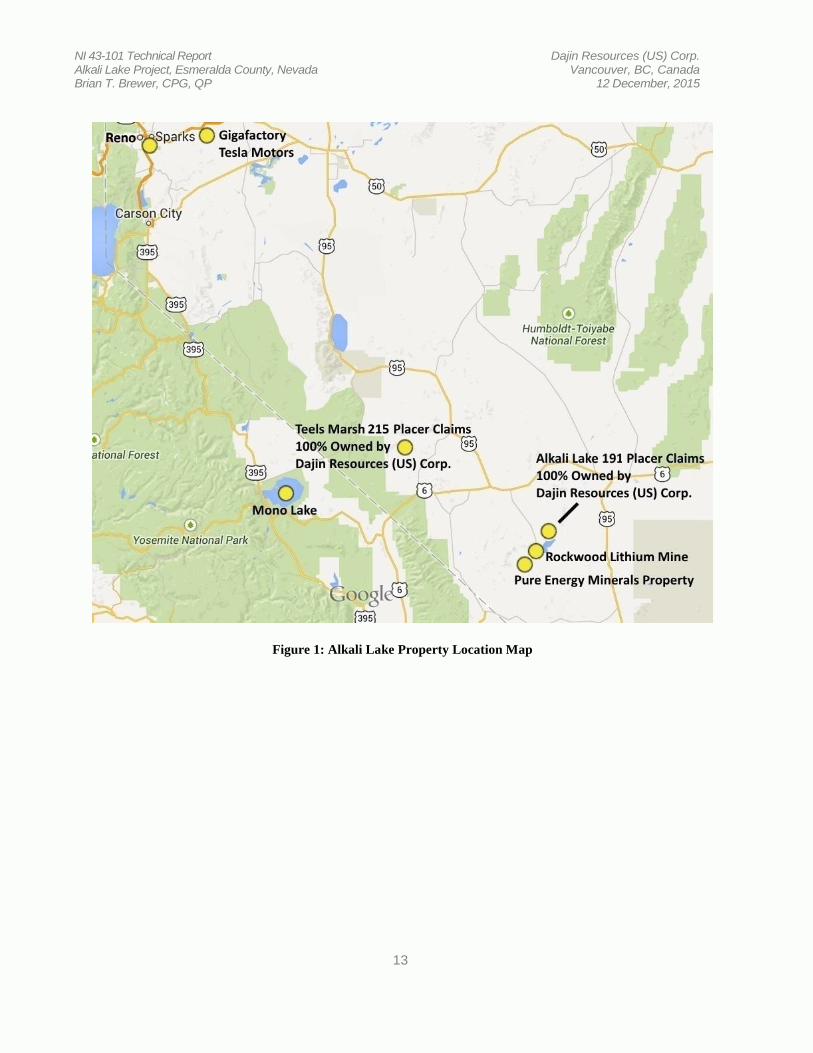
The Property is located in northeastern Esmeralda County approximately halfway between Las Vegas and Reno, Nevada and is situated in Sections 1, 3, 4, 7, 8, 9, 10, 11, 12, 13, 14, 16, 17, 18, 19 and 20 Township 41 South, Range 42 East and Sections 6, 7, and 18 Township 1 South, Range 42 East, Mount Diablo Meridian. USGS 7.5 minute quadrangles covering the Property include; Paymaster Canyon, Klondike, Paymaster Ridge and Alkali. The Property is approximately 15 miles southwest of Tonopah, Nevada and approximately 10 miles northeast of Rockwood Lithium Corporation’s Clayton Valley operation where lithium brines are processed in evaporation ponds producing a variety of lithium products. The property is best accessed by traveling south of Tonopah on US Highway 95 5.3 miles from the Nye / Esmeralda County line to a well maintained gravel road. This road is unmarked, but intersects US Highway 95 where the overhead power lines cross the highway, then tuning south on this gravel road and following the power line for 11.1 miles to another unmarked dirt road. Follow this road northwest for 2.4 miles to the eastern edge of Alkali Lake. 1.3 Geology and Mineralization The entire surface area of the Property is mapped as Quaternary playa and lake bed deposits and alluvium. The developing model which is most applicable to the Alkali Lake Property is a continental lithium brine which is the most important and the primary source of lithium of the three main types of lithium deposits (Kesler et al., 2012).

NI 43-101 Technical Report Dajin Resources (US) Corp. Alkali Lake Project, Esmeralda County, Nevada Vancouver, BC, Canada Brian T. Brewer, CPG, QP 12 December, 2015
8
1.4 Exploration
Very minimal exploration activity has been completed on the Alkali Lake Property to the author’s knowledge. This activity includes the recent completion of a gravity survey, collection of three (3) surface grab samples and a minimal sampling program utilizing a hand-auger to a maximum depth of seven (7) feet.
1.5 Drilling
To the author’s knowledge, no drilling has been conducted on the Alkali Lake Property.
1.6 Sample Preparation, Analysis and Security
No samples were collected by the author on this property. All known samples collected on this property were collected by a California Registered Professional Geologist in February 2015. His report, dated 03 July 2015, states that “Samples were collected in a 7” by 12.5” Hubco Sentry II bag made with spun-bonded polypropylene fabric, then zip-tied for security. All samples were transported to the home of the project geologist, where they were stored in a dry and secure location. The samples were then personally transported to Reno to the ALS Minerals facility for analysis prep.”
1.7 Data Verification
Although the author has not taken steps to verify the few samples collected, I am of the opinion that the work was completed utilizing acceptable industry standards. However, the accuracy of the historical data has not been verified and therefore should not be relied upon.
The geophysical data collected does not lend itself to the same data verification standards as sample collection, drilling and mapping, etc. Again, however, the author is of the opinion that all geophysical data collected was done so utilizing acceptable industry standards and techniques. The geophysical data compilation and interpretation was completed by a world -renowned reputable geophysical consulting firm.
1.8 Mineral Processing and Metallurgical Testing
No lithium bearing brines or fluids have been encountered or sampled on the Property to date to the author’s knowledge. Therefore, no process testing has been conducted. It is presumed that if lithium bearing brines occur on the Property that they could be treated in a similar manner as the techniques currently employed at the Rockwood Lithium Mine approximately 10 miles to the southwest.
Also, it is reported that considerable advances have recently been made in lithium processing. Including “Tenova Bateman Technologies (TBT) and POSCO (NYSE: PKX) have developed proven, innovative and sustainable lithium extraction technologies that outperform conventional processes. The innovative processes use selective mineral extraction technology to target lithium-bearing salts held within the brine and are reported to have significant advantages over conventional technology (source: Pure Energy Minerals Ltd.).
1.9 Mineral Resource Estimate

NI 43-101 Technical Report Dajin Resources (US) Corp. Alkali Lake Project, Esmeralda County, Nevada Vancouver, BC, Canada Brian T. Brewer, CPG, QP 12 December, 2015
9
The Alkali Lake Property is an early phase exploration property and a NI 43-101 compliant mineral resource has yet to be defined. 1.10 Conclusions and Recommendations The Alkali Lake Property is situated near proven lithium deposits and operating lithium producing projects. The geological concepts and targets for the Property are based on acceptable models and conclusions. While the Property is an early-stage exploration project and no lithium-bearing brines have been encountered as of this date, limited recent surface sampling has proven that the property contains measurable amounts of lithium. Also, the completed geophysical survey and associated interpretation indicate the presence of two deep-seated basins on the Property. Other basins in the area contain economic amounts of lithium-bearing brines that are currently being exploited. It is feasible that the Alkali Lake Property may be host to additional similar resources. Based on the conceptual model for this Property, the author thinks that the following additional exploration work is justified.
1. Complete additional gravity surveys near the edge of the indicated basins to add data in areas where “sparse” data exists for more complete interpretation.
2. A controlled source audio magneto-telluric (CSAMT) survey should be considered as an option for detailing the interpreted structures.
3. Conduct a bio-geochemical sampling program over the two claim blocks in order to identify areas of anomalous lithium geochemistry.
4. Initiate the permitting process for exploratory drilling. 5. Design and drill two (2) reverse-circulation drill holes in the center of the indicated basins to
verify the existence of the basins and attempt to encounter lithium-bearing brines. 6. Design and drill at least one (1) reverse-circulation drill hole in order to add density
constraints for interpretation of future gravity surveys and potential adjustment of current gravity data.
2.0 INTRODUCTION
This report was prepared by Brian T. Brewer, C.P.G., Q.P., at the request of Dajin Resources (US) Corporation for the purpose of providing a comprehensive overview of the historical exploration activities conducted on the Alkali Lake Property. This report is intended to comply with the standards dictated by National Instrument 43-101 with respect to the ALKL claim group located in Esmeralda County, Nevada.
This report is not intended to define any economic conclusions upon which to make a development decision for the project.
Brian T. Brewer understands that Dajin will use this report for reporting purposes.
Brian T. Brewer is a consulting geologist with approximately twenty two (22) years experience at all levels of mineral exploration and development for several commodities on three (3)

NI 43-101 Technical Report Dajin Resources (US) Corp. Alkali Lake Project, Esmeralda County, Nevada Vancouver, BC, Canada Brian T. Brewer, CPG, QP 12 December, 2015
10
continents. He is a Certified Professional Geologist through AIPG and a Fellow member of SEG. He provides his services through Brewer Exploration Incorporated in Salmon, Idaho.
2.1 Purpose and Terms of Reference
This report is prepared using the industry accepted Canadian Institute of Mining, Metallurgy and Petroleum (CIM) “Best Practices and Reporting Guidelines” for disclosing mineral exploration information, the Canadian Securities Administrators revised regulations in NI 43-101 (Standards of Disclosure for Mineral Projects) and Companion Policy 43-101CP and CIM Definition Standards for Mineral Resources and Mineral Reserves (December 11, 2005). Brian T. Brewer is not an associate or an affiliate of Dajin and his fee for this Technical Report is not dependent in whole or part on any prior or future engagement or understanding resulting from the conclusions of this report. The fee is in accordance with standard industry fees for work of this nature.
2.2 Sources of Information
The information for this report has been compiled by the author from historical reports and documents. The author, after reviewing these reports and documents, has no reason to believe that the information and data on which this report is based has been modified or misinterpreted so as to mislead a prudent reader. Nor does he know of any existing information, that has been deliberately omitted, which would refute any of the conclusions presented in this report.
2.3 Qualified Persons
The qualified person responsible for this report is Brian T. Brewer who is a consulting geologist contracted by Dajin Resources (US) Corp.
2.4 Effective Date
The effective date of this Technical Report is 12 December, 2015 2.5
2.5 Field Involvement of Qualified Person
Brian T. Brewer, C.P.G., Q.P. conducted a field review of the Alkali Lake Property and verified the accuracy of the field data collected.
2.6 Contributors to this Report
There were no other contributors to this report. 2.7 Units of Measure
2.7.1 Table of Common Units
Above mean sea level amsl Cubic Foot feet3
Cubic inch in3 Cubic yard yd3 Day d Degree °

NI 43-101 Technical Report Dajin Resources (US) Corp. Alkali Lake Project, Esmeralda County, Nevada Vancouver, BC, Canada Brian T. Brewer, CPG, QP 12 December, 2015
11
Degrees Fahrenheit °F Gallon gal Gallons per minute gpm Grams per tonne g/t Equal to or greater than ≥ Hectare ha Hour h Inch ” Kilo (thousand) k Equal to or less than ≤ Micrometer (micron) um Milligram mg Ounces per tonne oz/t Parts per billion ppb Parts per million ppm Percent %
Pounds lb Short ton (2,000lb) st Short ton (US) t Specific gravity SG Square foot feet2 Square inch in2 Yard yd Year (US) yr
2.7.2 Metric Conversion Factors (divided by)
Short tons to tonnes 1.10231 Pounds to tonnes 2204.62 Ounces (Troy) to tonnes 32150 Ounces (Troy) to kilograms 32.150 Ounces (Troy) to grams 0.03215 Ounces (Troy)/short ton to grams/tonne 0.02917
Acres to hectares 2.47105 Miles to kilometers 0.62137
Feet to meters 3.28084
2.7.3 Abbreviations
American Society for Testing and Materials ASTM Absolute Relative Difference ARD Atomic Absorption Spectrometry AAS Bureau of Land Management BLM Canadian Institute of Mining and Metallurgy CIM
Diamond Drill DD Global Positioning System GPS
Internal Rate of Return IRR Metallic Screen Fire Assay MSFA
National Instrument 43-101 NI 43-101 Nearest Neighbor NN

NI 43-101 Technical Report Dajin Resources (US) Corp. Alkali Lake Project, Esmeralda County, Nevada Vancouver, BC, Canada Brian T. Brewer, CPG, QP 12 December, 2015
12
Net Smelter Royalty NSR
Net Present Value NPV Probability Assigned Constrained Kriging PACK
Reverse Circulation RC/RCV Rock Quality Designation RQD Selective Mining Unit SMU
Universal Transverse Mercator UTM
3.0 RELIANCE ON OTHER EXPERTS
The author of the report has taken reasonable care that both the historical and current information used in this report is accurate and suitable for inclusion and has relied upon the work of other consultants. The sources of information included in this report are referenced in Section 17.
The author used his experience to determine if the information from previous reports was suitable for inclusion in this technical report and adjusted information that required amending. This report includes technical information, which required subsequent calculations to derive subtotals, totals and weighted averages. Such calculations inherently involve a degree of rounding and consequently introduce a margin of error. Where these occur, the author does not consider them to be material. 4.0 PROPERTY DESCRIPTION AND LOCATION 4.1 Location The Property is located in northeastern Esmeralda County approximately halfway between Las Vegas and Reno, Nevada and is situated in Sections 1, 3, 4, 7, 8, 9, 10, 11, 12, 13, 14, 16, 17, 18, 19 and 20 Township 41 South, Range 42 East and Sections 6, 7, and 18 Township 1 South, Range 42 East, Mount Diablo Meridian. USGS 7.5 minute quadrangles covering the Property include; Paymaster Canyon, Klondike, Paymaster Ridge and Alkali. The Property is approximately 15 miles southwest of Tonopah, Nevada and approximately 10 miles northeast of Rockwood Lithium Corporation’s Clayton Valley operation where lithium brines are processed in evaporation ponds producing a variety of lithium products. The property is best accessed by traveling south of Tonopah on US Highway 95 5.3 miles from the Nye / Esmeralda County line to a well maintained gravel road. This road is unmarked, but intersects US Highway 95 where the overhead power lines cross the highway, then tuning south on this gravel road and following the power line for 11.1 miles to another unmarked dirt road. Follow this road northwest for 2.4 miles to the eastern edge of Alkali Lake.
NI 43-101 Technical Report Dajin Resources (US) Corp. Alkali Lake Project, Esmeralda County, Nevada Vancouver, BC, Canada Brian T. Brewer, CPG, QP 12 December, 2015
13
Figure 1: Alkali Lake Property Location Map

NI 43-101 Technical Report Dajin Resources (US) Corp. Alkali Lake Project, Esmeralda County, Nevada Vancouver, BC, Canada Brian T. Brewer, CPG, QP 12 December, 2015
14
Figure 2: Alkali Lake Property Location on USGS Orthophoto

NI 43-101 Technical Report Dajin Resources (US) Corp. Alkali Lake Project, Esmeralda County, Nevada Vancouver, BC, Canada Brian T. Brewer, CPG, QP 12 December, 2015
15
Figure 3: Alkali Lake Property Location
4.2 Located Mineral Claims
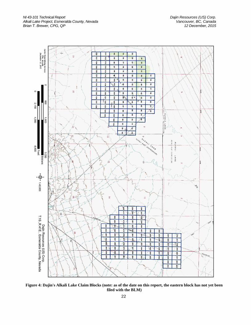
The Alkali Lake Property is comprised of 107 ALKL lithium placer claims. The claims are contained in one (1) contiguous claim block. All claims are located on unencumbered public land managed by the Federal Bureau of Land Management (BLM). As public lands, there is free right of access and both surface and mineral rights are held and managed by the Federal government.
Dajin recently completed a second claim block consisting of an additional 84 contiguous claims. These claims are referred to as the “eastern block” and are located approximately 2 miles east of the initial claim group. While these claims have been properly staked, they have yet to be filed with the BLM. According to the Federal Land Policy and Management Act of 1976 (FLMPA 43 (U.S.C. §1744)), Dajin has 90 days in which to file on these claims from the day that they were perfected (staked) on the ground. If Dajin complies with this regulation than the newly staked 84 claims will be valid. Otherwise, the claims will be null and void and the ground will revert back to a status open for available staking from another entitity.
During the property visit, the author checked several claim locations and discovery monuments and confirmed the presence of claim staking in the field. Recent claim staking was conducted by Carlin Trend Mining Services of Elko, Nevada, a reputable mining service contractor. The author conducted a review of the BLM database and confirmed that all claims that are subject to this report are active and held in good standing with the exception of the newly staked claims as mentioned above. There are no known environmental liabilities for the Dajin mining claims for this property. Also, there are no known significant factors or risks that may affect access, title or the right or ability to perform work on the Dajin claim area.

NI 43-101 Technical Report Dajin Resources (US) Corp. Alkali Lake Project, Esmeralda County, Nevada Vancouver, BC, Canada Brian T. Brewer, CPG, QP 12 December, 2015
16
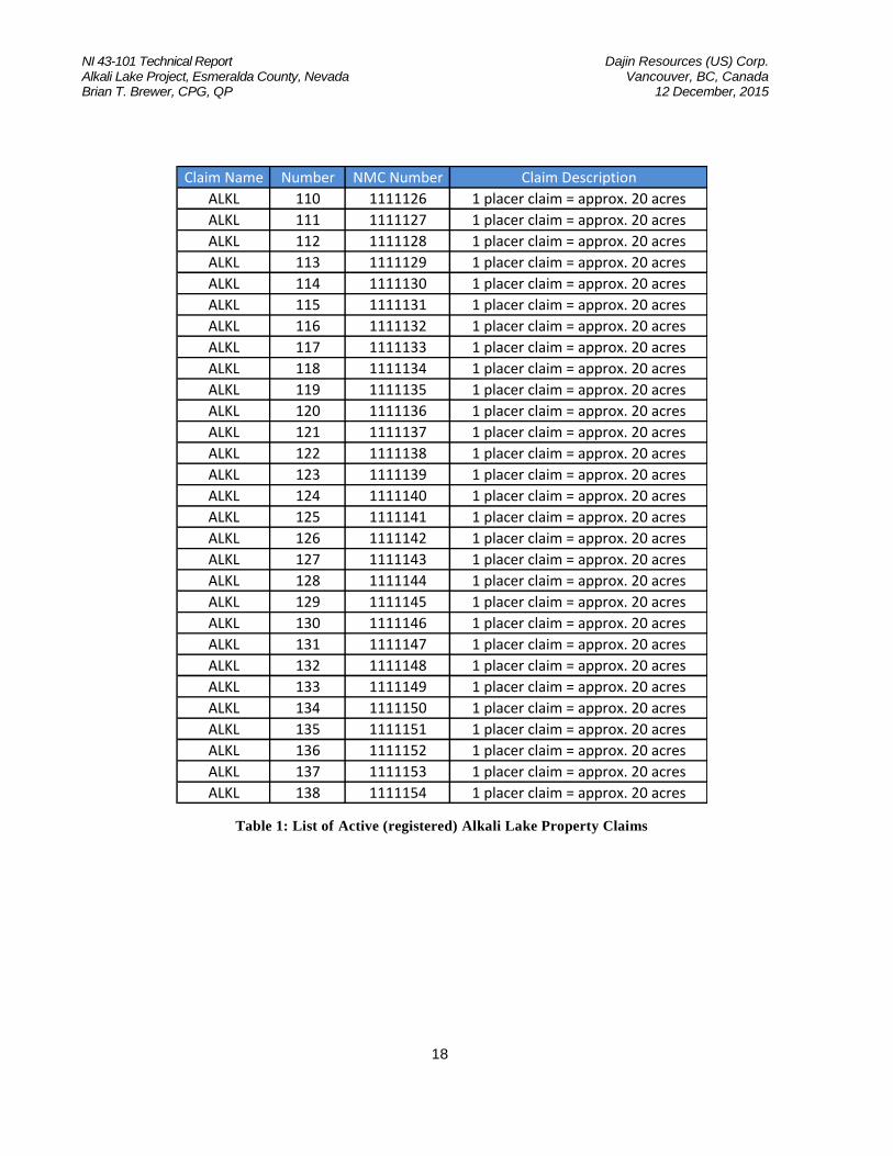
Claim Name Number NMC Number Claim Description
ALKL 14 1111030 1 placer claim = approx. 20 acres
ALKL 15 1111031 1 placer claim = approx. 20 acres
ALKL 16 1111032 1 placer claim = approx. 20 acres
ALKL 17 1111033 1 placer claim = approx. 20 acres
ALKL 18 1111034 1 placer claim = approx. 20 acres
ALKL 19 1111035 1 placer claim = approx. 20 acres
ALKL 20 1111036 1 placer claim = approx. 20 acres
ALKL 21 1111037 1 placer claim = approx. 20 acres
ALKL 22 1111038 1 placer claim = approx. 20 acres
ALKL 34 1111050 1 placer claim = approx. 20 acres
ALKL 35 1111051 1 placer claim = approx. 20 acres
ALKL 36 1111052 1 placer claim = approx. 20 acres
ALKL 37 1111053 1 placer claim = approx. 20 acres
ALKL 38 1111054 1 placer claim = approx. 20 acres
ALKL 39 1111055 1 placer claim = approx. 20 acres
ALKL 40 1111056 1 placer claim = approx. 20 acres
ALKL 41 1111057 1 placer claim = approx. 20 acres
ALKL 42 1111058 1 placer claim = approx. 20 acres
ALKL 43 1111059 1 placer claim = approx. 20 acres
ALKL 44 1111060 1 placer claim = approx. 20 acres
ALKL 45 1111061 1 placer claim = approx. 20 acres
ALKL 46 1111062 1 placer claim = approx. 20 acres
ALKL 47 1111063 1 placer claim = approx. 20 acres
ALKL 48 1111064 1 placer claim = approx. 20 acres
ALKL 49 1111065 1 placer claim = approx. 20 acres
ALKL 55 1111071 1 placer claim = approx. 20 acres
ALKL 56 1111072 1 placer claim = approx. 20 acres
ALKL 57 1111073 1 placer claim = approx. 20 acres
ALKL 58 1111074 1 placer claim = approx. 20 acres
ALKL 59 1111075 1 placer claim = approx. 20 acres
ALKL 60 1111076 1 placer claim = approx. 20 acres
ALKL 61 1111077 1 placer claim = approx. 20 acres
ALKL 62 1111078 1 placer claim = approx. 20 acres
ALKL 63 1111079 1 placer claim = approx. 20 acres
ALKL 64 1111080 1 placer claim = approx. 20 acres
ALKL 65 1111081 1 placer claim = approx. 20 acres
ALKL 66 1111082 1 placer claim = approx. 20 acres
ALKL 67 1111083 1 placer claim = approx. 20 acres
ALKL 68 1111084 1 placer claim = approx. 20 acres

NI 43-101 Technical Report Dajin Resources (US) Corp. Alkali Lake Project, Esmeralda County, Nevada Vancouver, BC, Canada Brian T. Brewer, CPG, QP 12 December, 2015
17
Claim Name Number NMC Number Claim Description
ALKL 69 1111085 1 placer claim = approx. 20 acres
ALKL 70 1111086 1 placer claim = approx. 20 acres
ALKL 71 1111087 1 placer claim = approx. 20 acres
ALKL 72 1111088 1 placer claim = approx. 20 acres
ALKL 73 1111089 1 placer claim = approx. 20 acres
ALKL 75 1111091 1 placer claim = approx. 20 acres
ALKL 76 1111092 1 placer claim = approx. 20 acres
ALKL 77 1111093 1 placer claim = approx. 20 acres
ALKL 78 1111094 1 placer claim = approx. 20 acres
ALKL 79 1111095 1 placer claim = approx. 20 acres
ALKL 80 1111096 1 placer claim = approx. 20 acres
ALKL 81 1111097 1 placer claim = approx. 20 acres
ALKL 82 1111098 1 placer claim = approx. 20 acres
ALKL 83 1111099 1 placer claim = approx. 20 acres
ALKL 84 1111100 1 placer claim = approx. 20 acres
ALKL 85 1111101 1 placer claim = approx. 20 acres
ALKL 86 1111102 1 placer claim = approx. 20 acres
ALKL 87 1111103 1 placer claim = approx. 20 acres
ALKL 88 1111104 1 placer claim = approx. 20 acres
ALKL 89 1111105 1 placer claim = approx. 20 acres
ALKL 90 1111106 1 placer claim = approx. 20 acres
ALKL 91 1111107 1 placer claim = approx. 20 acres
ALKL 92 1111108 1 placer claim = approx. 20 acres
ALKL 93 1111109 1 placer claim = approx. 20 acres
ALKL 94 1111110 1 placer claim = approx. 20 acres
ALKL 95 1111111 1 placer claim = approx. 20 acres
ALKL 96 1111112 1 placer claim = approx. 20 acres
ALKL 97 1111113 1 placer claim = approx. 20 acres
ALKL 98 1111114 1 placer claim = approx. 20 acres
ALKL 99 1111115 1 placer claim = approx. 20 acres
ALKL 100 1111116 1 placer claim = approx. 20 acres
ALKL 101 1111117 1 placer claim = approx. 20 acres
ALKL 102 1111118 1 placer claim = approx. 20 acres
ALKL 103 1111119 1 placer claim = approx. 20 acres
ALKL 104 1111120 1 placer claim = approx. 20 acres
ALKL 105 1111121 1 placer claim = approx. 20 acres
ALKL 106 1111122 1 placer claim = approx. 20 acres
ALKL 107 1111123 1 placer claim = approx. 20 acres
ALKL 108 1111124 1 placer claim = approx. 20 acres
ALKL 109 1111125 1 placer claim = approx. 20 acres
NI 43-101 Technical Report Dajin Resources (US) Corp. Alkali Lake Project, Esmeralda County, Nevada Vancouver, BC, Canada Brian T. Brewer, CPG, QP 12 December, 2015
18
Claim Name Number NMC Number Claim Description
ALKL 110 1111126 1 placer claim = approx. 20 acres
ALKL 111 1111127 1 placer claim = approx. 20 acres
ALKL 112 1111128 1 placer claim = approx. 20 acres
ALKL 113 1111129 1 placer claim = approx. 20 acres
ALKL 114 1111130 1 placer claim = approx. 20 acres
ALKL 115 1111131 1 placer claim = approx. 20 acres
ALKL 116 1111132 1 placer claim = approx. 20 acres
ALKL 117 1111133 1 placer claim = approx. 20 acres
ALKL 118 1111134 1 placer claim = approx. 20 acres
ALKL 119 1111135 1 placer claim = approx. 20 acres
ALKL 120 1111136 1 placer claim = approx. 20 acres
ALKL 121 1111137 1 placer claim = approx. 20 acres
ALKL 122 1111138 1 placer claim = approx. 20 acres
ALKL 123 1111139 1 placer claim = approx. 20 acres
ALKL 124 1111140 1 placer claim = approx. 20 acres
ALKL 125 1111141 1 placer claim = approx. 20 acres
ALKL 126 1111142 1 placer claim = approx. 20 acres
ALKL 127 1111143 1 placer claim = approx. 20 acres
ALKL 128 1111144 1 placer claim = approx. 20 acres
ALKL 129 1111145 1 placer claim = approx. 20 acres
ALKL 130 1111146 1 placer claim = approx. 20 acres
ALKL 131 1111147 1 placer claim = approx. 20 acres
ALKL 132 1111148 1 placer claim = approx. 20 acres
ALKL 133 1111149 1 placer claim = approx. 20 acres
ALKL 134 1111150 1 placer claim = approx. 20 acres
ALKL 135 1111151 1 placer claim = approx. 20 acres
ALKL 136 1111152 1 placer claim = approx. 20 acres
ALKL 137 1111153 1 placer claim = approx. 20 acres
ALKL 138 1111154 1 placer claim = approx. 20 acres
Table 1: List of Active (registered) Alkali Lake Property Claims

NI 43-101 Technical Report Dajin Resources (US) Corp. Alkali Lake Project, Esmeralda County, Nevada Vancouver, BC, Canada Brian T. Brewer, CPG, QP 12 December, 2015
19
Claim Name Number Claim Description
ALKL 216 placer, staked pending filing and issuance of NMC #
ALKL 217 placer, staked pending filing and issuance of NMC #
ALKL 218 placer, staked pending filing and issuance of NMC #
ALKL 219 placer, staked pending filing and issuance of NMC #
ALKL 220 placer, staked pending filing and issuance of NMC #
ALKL 221 placer, staked pending filing and issuance of NMC #
ALKL 222 placer, staked pending filing and issuance of NMC #
ALKL 223 placer, staked pending filing and issuance of NMC #
ALKL 224 placer, staked pending filing and issuance of NMC #
ALKL 225 placer, staked pending filing and issuance of NMC #
ALKL 226 placer, staked pending filing and issuance of NMC #
ALKL 227 placer, staked pending filing and issuance of NMC #
ALKL 228 placer, staked pending filing and issuance of NMC #
ALKL 229 placer, staked pending filing and issuance of NMC #
ALKL 230 placer, staked pending filing and issuance of NMC #
ALKL 231 placer, staked pending filing and issuance of NMC #
ALKL 232 placer, staked pending filing and issuance of NMC #
ALKL 233 placer, staked pending filing and issuance of NMC #
ALKL 234 placer, staked pending filing and issuance of NMC #
ALKL 235 placer, staked pending filing and issuance of NMC #
ALKL 236 placer, staked pending filing and issuance of NMC #
ALKL 237 placer, staked pending filing and issuance of NMC #
ALKL 238 placer, staked pending filing and issuance of NMC #
ALKL 239 placer, staked pending filing and issuance of NMC #
ALKL 240 placer, staked pending filing and issuance of NMC #
ALKL 241 placer, staked pending filing and issuance of NMC #
ALKL 242 placer, staked pending filing and issuance of NMC #
ALKL 243 placer, staked pending filing and issuance of NMC #
ALKL 244 placer, staked pending filing and issuance of NMC #
ALKL 245 placer, staked pending filing and issuance of NMC #
ALKL 246 placer, staked pending filing and issuance of NMC #
ALKL 247 placer, staked pending filing and issuance of NMC #
ALKL 248 placer, staked pending filing and issuance of NMC #
ALKL 249 placer, staked pending filing and issuance of NMC #
ALKL 250 placer, staked pending filing and issuance of NMC #
ALKL 251 placer, staked pending filing and issuance of NMC #
ALKL 252 placer, staked pending filing and issuance of NMC #
ALKL 253 placer, staked pending filing and issuance of NMC #
ALKL 254 placer, staked pending filing and issuance of NMC #

NI 43-101 Technical Report Dajin Resources (US) Corp. Alkali Lake Project, Esmeralda County, Nevada Vancouver, BC, Canada Brian T. Brewer, CPG, QP 12 December, 2015
20
Claim Name Number Claim Description
ALKL 255 placer, staked pending filing and issuance of NMC #
ALKL 256 placer, staked pending filing and issuance of NMC #
ALKL 257 placer, staked pending filing and issuance of NMC #
ALKL 258 placer, staked pending filing and issuance of NMC #
ALKL 259 placer, staked pending filing and issuance of NMC #
ALKL 260 placer, staked pending filing and issuance of NMC #
ALKL 261 placer, staked pending filing and issuance of NMC #
ALKL 262 placer, staked pending filing and issuance of NMC #
ALKL 263 placer, staked pending filing and issuance of NMC #
ALKL 264 placer, staked pending filing and issuance of NMC #
ALKL 265 placer, staked pending filing and issuance of NMC #
ALKL 266 placer, staked pending filing and issuance of NMC #
ALKL 267 placer, staked pending filing and issuance of NMC #
ALKL 268 placer, staked pending filing and issuance of NMC #
ALKL 269 placer, staked pending filing and issuance of NMC #
ALKL 270 placer, staked pending filing and issuance of NMC #
ALKL 271 placer, staked pending filing and issuance of NMC #
ALKL 272 placer, staked pending filing and issuance of NMC #
ALKL 273 placer, staked pending filing and issuance of NMC #
ALKL 274 placer, staked pending filing and issuance of NMC #
ALKL 275 placer, staked pending filing and issuance of NMC #
ALKL 276 placer, staked pending filing and issuance of NMC #
ALKL 277 placer, staked pending filing and issuance of NMC #
ALKL 278 placer, staked pending filing and issuance of NMC #
ALKL 279 placer, staked pending filing and issuance of NMC #
ALKL 280 placer, staked pending filing and issuance of NMC #
ALKL 281 placer, staked pending filing and issuance of NMC #
ALKL 282 placer, staked pending filing and issuance of NMC #
ALKL 283 placer, staked pending filing and issuance of NMC #
ALKL 284 placer, staked pending filing and issuance of NMC #
ALKL 285 placer, staked pending filing and issuance of NMC #
ALKL 286 placer, staked pending filing and issuance of NMC #
ALKL 287 placer, staked pending filing and issuance of NMC #
ALKL 288 placer, staked pending filing and issuance of NMC #
ALKL 289 placer, staked pending filing and issuance of NMC #
ALKL 290 placer, staked pending filing and issuance of NMC #
ALKL 291 placer, staked pending filing and issuance of NMC #
ALKL 292 placer, staked pending filing and issuance of NMC #
ALKL 293 placer, staked pending filing and issuance of NMC #

NI 43-101 Technical Report Dajin Resources (US) Corp. Alkali Lake Project, Esmeralda County, Nevada Vancouver, BC, Canada Brian T. Brewer, CPG, QP 12 December, 2015
21
Claim Name Number Claim Description
ALKL 294 placer, staked pending filing and issuance of NMC #
ALKL 295 placer, staked pending filing and issuance of NMC #
ALKL 296 placer, staked pending filing and issuance of NMC #
ALKL 297 placer, staked pending filing and issuance of NMC #
ALKL 298 placer, staked pending filing and issuance of NMC #
ALKL 299 placer, staked pending filing and issuance of NMC #
Table 2: List of Pending Alkali Lake Property Claims
NI 43-101 Technical Report Dajin Resources (US) Corp. Alkali Lake Project, Esmeralda County, Nevada Vancouver, BC, Canada Brian T. Brewer, CPG, QP 12 December, 2015
22
Figure 4: Dajin's Alkali Lake Claim Blocks (note: as of the date on this report, the eastern block has not yet been
filed with the BLM)

NI 43-101 Technical Report Dajin Resources (US) Corp. Alkali Lake Project, Esmeralda County, Nevada Vancouver, BC, Canada Brian T. Brewer, CPG, QP 12 December, 2015
23
4.3 Property Agreements and Royalties The author understands that Dajin Resources (US) Corp. owns 100% of the Alkali Lake Property without encumbrances.
4.4 Environmental Liability
The environmental liability has not been researched or investigated in detail. However, the author is not aware of any recognizable environmental liabilities associated with the Property at this time.
4.5 Operational Permits and Jurisdictions
There are no current operational permits associated with the Property. Before initiation of a drilling program, Dajin will be required to obtain a Permit after furnishing the BLM a Notice of Intent (NOI). This Permit will allow for total ground disturbance of up to 5 acres and will require a reclamation bond to be in place. This bond will be returned once the area disturbed is reclaimed. A Plan of Operation (POO) is required to be filed with the local BLM office if the amount of disturbance planned is over 5 acres. The Property falls under the jurisdiction of the United States Bureau of Land Management (BLM). The author would expect relative ease in permitting future exploration activities based on the location, type of terrain and apparent lack of wildlife and vegetation resources on the property.
4.6 Requirements to Maintain the Claims in Good Standing
To maintain mining claims in good standing, a claim holder must make annual maintenance fee payments to the BLM in lieu of annual assessment work. This annual claim maintenance fee is currently $155.00 per claim per year and is payable to the State BLM office on or before 01 September.
4.7 Significant Risk Factors
The author is not aware of any significant factors or risks that may affect access, title, or the right or ability to perform work on this property.
5.0 ACCESS, CLIMATE, RESOURCES, INFRASTRUCTURE AND PHYSIOGRAPHY
5.1 Accessibility The Property is located in northeastern Esmeralda County approximately halfway between Las Vegas and Reno, Nevada and is situated in Sections 1, 3, 4, 7, 8, 9, 10, 11, 12, 13, 14, 16, 17, 18, 19 and 20 Township 41 South, Range 42 East and Sections 6, 7, and 18 Township 1 South, Range 42 East, Mount Diablo Meridian. USGS 7.5 minute quadrangles covering the Property include; Paymaster Canyon, Klondike, Paymaster Ridge and Alkali. The Property is approximately 15 miles southwest of Tonopah, Nevada and approximately 10 miles northeast of Rockwood Lithium Corporation’s Clayton Valley operation where lithium brines are processed in evaporation ponds producing a variety of lithium products. The property is best accessed by traveling south of Tonopah on US Highway 95 5.3 miles from the

NI 43-101 Technical Report Dajin Resources (US) Corp. Alkali Lake Project, Esmeralda County, Nevada Vancouver, BC, Canada Brian T. Brewer, CPG, QP 12 December, 2015
24
Nye / Esmeralda County line to a well maintained gravel road. This road is unmarked, but intersects US Highway 95 where the overhead power lines cross the highway, then tuning south on this gravel road and following the power line for 11.1 miles to another unmarked dirt road. Follow this road northwest for 2.4 miles to the eastern edge of Alkali Lake.
5.2 Climate and Physiography
The Alkali Lake Property has a generally arid to semi-arid climate, characterized by hot dry summers and cold winters. Precipitation is scattered throughout the year, with slightly more precipitation in late winter/early spring. During the winter months, high-pressure conditions predominate resulting in west-to-east trending winds and precipitation patterns. During the summer months, low-pressure conditions predominate, resulting in southwest-to-northeast trending precipitation patterns. Winter storm events tend to last longer and produce more precipitation than the summer events, which tend to produce widely scattered showers of short duration; drought is common and can last for more than 100 days.
The average potential evaporation rate for Esmeralda County exceeds the average annual precipitation, and on an annual basis as much as 95% of the total annual precipitation is lost through evaporation and transpiration (less than 10% recharges to groundwater). Localized dust storms are common in the area, and typically form later in the day after pronounced solar heating of the ground surface (all general climate information sourced from Esmeralda County Water Resource Plan; www.accessesmeralda.com).
Vegetation coverage across the property area is generally very sparse, with many areas on the flat playa floor and the sand dune area having effectively no vegetation cover at all. Aside from the very lowest part of the playa floor, the vegetation consists of a mixture of low scrub and grasses forming high desert, prairie or shrub-steppe vegetation populations.

NI 43-101 Technical Report Dajin Resources (US) Corp. Alkali Lake Project, Esmeralda County, Nevada Vancouver, BC, Canada Brian T. Brewer, CPG, QP 12 December, 2015
25
Figure 5: Alkali Lake Area Looking North, 10 December 2015
5.3 Local Resources and Infrastructure The Property lies approximately nineteen (19) road miles from Tonopah which has a population of around 2500 and is the county seat for Nye County. Tonopah acts as the governmental and supply center for the region and has ample infrastructure including; groceries, hardware, banking, motels, restaurants and emergency services to support exploration and mining activities. 6.0 HISTORY Reportedly, (Evans, 2015) there are at least two (2) steel drill casings on the property of unknown origin, date and purpose. One of these casings is 10 inches in diameter and the other is 12 inches in diameter. It is presumed that these may have been drilled by Foote Mineral Company in the 1960s or 1970s. To the author’s knowledge, there is no other history of lithium exploration on the Property prior to Dajin’s efforts. 6.1History of Clayton Valley (Spanjers, 2015) The Alkali Lake Property is located approximately ten (10) miles northeast of Rockwood Lithium Corp’s Clayton Valley operation. The following descriptions and narratives for this section were copied from the Inferred Resource Estimate for Lithium, Clayton Valley South Project, Technical

NI 43-101 Technical Report Dajin Resources (US) Corp. Alkali Lake Project, Esmeralda County, Nevada Vancouver, BC, Canada Brian T. Brewer, CPG, QP 12 December, 2015
26
Report for NI 43-101, Prepared on Behalf of Pure Energy Minerals LTD (Spanjers, 2015).
Clayton Valley is the location of the only operating lithium mine in North America. Albemarle Corporation is the present owner of the brine processing evaporation pond and plant complex, known as the Silver Peak Operations, which has been in existence since 1967. Previous owners include Newmont (Foote Mineral Company), Chemetall-Foote Corporation and Rockwood Holdings, Inc. Albemarle Corporation purchased Rockwood Holdings, Inc. in 2014 for US$6.2 Billion, which included the Salar de Atacama brine operation in Chile, a lithium chemical processing plant in North Carolina and the Silver Peak operations in Nevada. Production data from the Silver Peak operations is proprietary and unpublished. However, the 2014 Rockwood Holdings Inc. Annual Report cites production in 2013 at 870 metric tons Li. Previous production was reported by Price, Lechler, Lear and Giles (2000) at 25,600 metric tons Li through 1991. Garrett (2004) reported 5,700 metric tons Li2CO3, (1,072 metric tons Li) in 1997. The Li concentration in the production brines averaged 400 ppm initially, dropped to 300 ppm in 1970 and 160 ppm in 2001 (Garrett, 2004). The historical lithium brine resource in Clayton Valley has been estimated at 0.7 Mt Li (Kunasz, 1975), 0.65 Mt Li (Price et al., 2000) and 0.4 Mt Li (Yaksic and Tilton, 2009). These resource estimates cannot be confirmed and are not necessarily indicative of the mineralization on the property that is the subject of this technical report. Rodinia Lithium, Inc., under its wholly owned Wyoming subsidiary Donnybrook Platinum Resources, Inc. and GeoXplor Corp., acquired 1,012 lode and placer claims (total of 72,340 acres), on Bureau of Land Management (BLM) land in Clayton Valley. The claims surrounded, and were adjacent to, the existing Silver Peak lithium operations to the north, east and south. The preponderance of the claims covered the south valley and included the current Pure Energy interest. In 2009, Rodinia completed 3.6 km seismic survey on the north side of Clayton Valley to define the depth to basement and location of the Paymaster Fault, a north-south structure thought to control lithium brine movement. Rodinia followed with a gravity survey by Hasbrouck Geophysics Inc. and completed a 274-point gravity survey and subsequent report on the Rodinia claims. The results defined a 1.0-1.7 km (0.6-1 mile) deep structural trough oriented northeast-southwest across the southern valley. The trough extends through the length of the Pure Energy claims. Rodinia completed 9 Dual Wall Reverse Circulation (DWRC) boreholes during 2010 around the perimeter of the existing Albemarle operation (Table 6). Of significance to this report are 2 drill holes, SPD-8 and SPD-9, located near the southeast portion of the Albemarle patented claims (northeast portion of the Pure Energy claims). These holes penetrated zones of anomalous Li content. In 2010 Rodinia completed several segments of an Exploration Plan of Operation, a document required for further exploration and land disturbance beyond the initial five acre BLM permit. Cultural and environmental surveys were completed by independent contractors on acreage proposed for an extensive drilling program in the south portion of Clayton Valley. Rodinia eventually dropped all claims in order to concentrate resources on its Salar de Diablillos lithium project in the Puna of Argentina.

NI 43-101 Technical Report Dajin Resources (US) Corp. Alkali Lake Project, Esmeralda County, Nevada Vancouver, BC, Canada Brian T. Brewer, CPG, QP 12 December, 2015
27
7.0 GEOLOGICAL SETTING AND MINERALIZATION
7.1 Regional Geology
The Alkali Lake Property lies within the Basin and Range Province in southern Nevada. The basement rock of the region consists of late Neoproterozoic to Ordovician carbonate and clastic rocks that were deposited along the ancient western passive margin of North America. During late Paleozoic and Mesozoic orogenies, the region was shortened and subjected to lowgrade metamorphism (Oldow et al., 1989; Oldow et al., 2009) and granitoids were emplaced at ca. 155 and 85 Ma. Extension commenced at ca. 16 Ma and has continued to the present, with changes in structural style as documented in the Silver Peak-Lone Mountain Extensional Complex (Oldow et al., 2009; Burris, 2013). Multiple wetting and drying periods during the Pleistocene resulted in the formation of lacustrine deposits and salt beds in the area. Tertiary age volcanic rocks are interspersed around the Property.
Figure 6: Regional Geology Map of Stewart and Carlson (1978)
7.2 Property Geology The Property is mapped entirely as Quaternary age playa and lake bed deposits and alluvium.
7.3 Mineralization The term “mineralization” is not wholly applicable to this Property.
NI 43-101 Technical Report Dajin Resources (US) Corp. Alkali Lake Project, Esmeralda County, Nevada Vancouver, BC, Canada Brian T. Brewer, CPG, QP 12 December, 2015
28
7.4 Alteration
The term “alteration” is not wholly applicable to this Property. 8.0 DEPOSIT TYPE The developing model which is most applicable to the Alkali Lake Property is a continental lithium brine which is the most important and the primary source of lithium of the three main types of lithium deposits (Kesler et al., 2012). Bradley, et al. (2013) noted that “all producing lithium brine deposits share a number of first-order characteristics: (1) arid climate; (2) closed basin containing a playa or salar; (3) tectonically driven subsidence; (4) associated igneous or geothermal activity; (5) suitable lithium source-rocks; (6) one or more adequate aquifers; and (7) sufficient time to concentrate a brine.” The Li atom does not readily form evaporite minerals, remains in solution and concentrates to high levels, reaching 4,000 ppm at Salar de Atacama. Large deposits are mined in the Salar de Atacama, Chile (SQM and Albemarle), Salar de Hombre Muerto, Argentina (FMC) and Clayton Valley, Nevada (Albemarle), the only North American producer. Lithium brine deposit models have been discussed by Houston et al. (2011), Bradley et al. (2013) and more extensively by Munk et al. (in press). Houston et al. (2011) classified the salars in the Altiplano-Puna region of the Central Andes, South America in terms of two end members, “immature clastic” or “mature halite,” primarily using (1) the relative amount of clastic versus evaporate sediment; (2) climatic and tectonic influences, as related to altitude and latitude; and (3) basic hydrology, which controls the influx of fresh water. The immature classification refers to basins that generally occur at higher (wetter) elevations in the north and east of the region, contain alternating clastic and evaporite sedimentary sequences dominated by gypsum, have recycled salts, and a general low abundance of halite. Mature refers to salars in arid to hyperarid climates, which occur in the lower elevations of the region, reach halite saturation, and have intercalated clay and silt and/or volcanic deposits. An important point made by Houston et al. (2011) is the relative significance of aquifer permeability which is controlled by the geological and geochemical composition of the aquifers. For example, immature salars may contain large volumes of easily extractable lithium -rich brines simply because they are comprised of a mixture of clastic and evaporite aquifer materials that have higher porosity and permeability. The Clayton Valley salar has characteristics more like an immature salar. 9.0 EXPLORATION
9.1 Surface Sampling
The author has not collected any samples from this Property.
Western Geoscience, Inc. of Mina, Nevada conducted a limited sampling program in February 2015. According to the subsequent report from Western Geoscience, a total of nine (9) sites were selected for sampling with a hand-operated auger. Each site was prepared utilizing a metal bar to start each hole. Then a 3-foot long by 8-inch diameter motorized auger was used. Due to the hardness of the ground, this auger bit was only able to penetrate “a foot or so”. At this point, a 3.5-inch diameter by 8-foot long bit was used to deepen the hole. Again, because of the hardness of the ground, this

NI 43-101 Technical Report Dajin Resources (US) Corp. Alkali Lake Project, Esmeralda County, Nevada Vancouver, BC, Canada Brian T. Brewer, CPG, QP 12 December, 2015
29
proved to be ineffective. Attempts were made to soften the ground by applying purified water. However, the water had difficulties penetrating the ground and a metal bar was used past the point of dampness. Of the nine (9) sites identified for auger sampling, only five (5) were sampled before the decision was made to terminate the effort. The deepest hole reached a maximum depth of seven (7) feet. Of the five (5) holes drilled, three (3) samples were taken from hole NW-136, two (2) taken from hole NW-117 and two (2) taken from hole NW-130. One (1) sample was taken from each of the holes NW-71 and NW-84. The table below shows the location of the holes, sample numbers and their respective Li values.
HOLE ID UTM NAD 27
MAX. DEPTH SAMPLE ID Li (ppm) EASTING NORTHING
NW-71 0466477 4190576 3 NW71A 75.6
NW-84 0465065 4190196 2 NW84A 92
NW-117 0464460 4189385 5.4 NW117A 86.4
NW117B 94.7
NW-130 0464052 4188974 5 NW130A 86.7
NW130B 93.5
NW-136 0465359 4188970 7
NW136A 90.3
NW136B 73.2
NW136C 75 Table 3: Auger Samples
In conjunction with the above samples, Western Geoscience, collected five (5) grab samples from three (3) different locations. These samples are detailed below.
SAMPLE ID UTM NAD 27
Li (ppm) EASTING NORTHING
ALK1 0467748 4190423 382
ALK2 0466913 4190133 303
ALK3
0465842 4189469
91.7
ALK3A 112.5
ALK3B 102 Table 4: Grab Samples
All of the above samples were analyzed by ALS Minerals Laboratory of Reno, Nevada utilizing a 51 element ICP-MS and ICP-AES by agua regia methodology (ME-MS41). Samples were received at the ALS facility on 06 March 2015 and the final assay certificate (RE15032560) was issued on 21 March 2015.
9.2 Geophysical Surveys A gravity survey was completed over the Property from June 18 – 21, 2015 with the objective of procuring a model of the basin fill as an aid to lithium exploration. Results of the survey were integrated with an earlier airborne magnetic survey completed by the USGS. A total of 566 gravity stations were completed. The stations were acquired on a 250 meter by 500 meter grid and along surrounding public roads and cross-county profiles at station spacing of approximately one kilometer. In addition to the surveyed stations, public domain USGS stations were merged into the database to provide regional coverage around the property scale survey. The airborne magnetic

NI 43-101 Technical Report Dajin Resources (US) Corp. Alkali Lake Project, Esmeralda County, Nevada Vancouver, BC, Canada Brian T. Brewer, CPG, QP 12 December, 2015
30
survey was conducted in 1977 as part of the National Uranium Resource Evaluation (NURE) uranium assessment program. The gravity field data was collected by Magee Geophysical Services LLC of Reno, Nevada and Wright Geophysics Inc. of Elko, Nevada conducted the data compilation, interpretation and generation of the 3D gravity and airborne magnetic models.
Figure 7: Gravity Station Plots and Basin Model Overlain on Geology
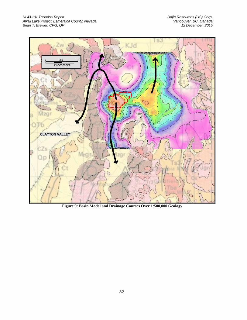
Interpretation of the geophysical data suggests the Property area is underlain by two basins. The first is a circular basin directly beneath Alkali Lake at an estimated depth of 4,000 feet. The second basin is approximately 1.8 miles east of the first basin, is north-south elongated, is overlain by the pending eastern block of claims staked by Dajin and has an estimated depth of 3,000 to 4,000 feet. The two basins are separated by a northwest – southeast trending saddle or bedrock ridge. Strong structural controls are indicated for the western basin and the more gently sloping sides of the eastern basin suggest less structural controls. Four “saddles” are identified along branches of the basin. These branches exit the basin in three directions with one saddle connecting the two basin bottoms. An intrusion is interpreted bounding the basin to the north with very shallow basin cover; it appears to be an outlier to the strongly magnetic General Thomas Hills intrusion further north. Several of the branches along the margin of the basin provide possible avenues for fluid flow into and out of the basin. The northwest corner of the basin connects to drainages running down Paymaster Canyon into the northeast end of Clayton Valley. However, a saddle (Saddle 1) in the northwestern area of the survey in the basin bottom effectively closes this avenue. Saddles 2 and 4 also limit deep fluid flow into and out of the basin. To the extent these barriers prevent fluid flow, the basin is closed. However; deep, highly permeable structures within the bedrock could serve as conduits for fluid movement, which the basin model does not detect.

NI 43-101 Technical Report Dajin Resources (US) Corp. Alkali Lake Project, Esmeralda County, Nevada Vancouver, BC, Canada Brian T. Brewer, CPG, QP 12 December, 2015
31
Figure 8: Interpreted Structures and Basin Model Overlain on Geology
NI 43-101 Technical Report Dajin Resources (US) Corp. Alkali Lake Project, Esmeralda County, Nevada Vancouver, BC, Canada Brian T. Brewer, CPG, QP 12 December, 2015
32
Figure 9: Basin Model and Drainage Courses Over 1:500,000 Geology

NI 43-101 Technical Report Dajin Resources (US) Corp. Alkali Lake Project, Esmeralda County, Nevada Vancouver, BC, Canada Brian T. Brewer, CPG, QP 12 December, 2015
33
Figure 10: Overview of Alkali Lake Gravity Model

NI 43-101 Technical Report Dajin Resources (US) Corp. Alkali Lake Project, Esmeralda County, Nevada Vancouver, BC, Canada Brian T. Brewer, CPG, QP 12 December, 2015
34
10.0 Drilling To the author’s knowledge, no recent drilling has been completed on the Property. 11.0 SAMPLE PREPARATION, ANALYSIS AND SECURITY The author has not collected any sample on this property. For the fourteen (14) surface samples discussed previously, Western Geoscience, Inc reports that “Samples were collected ina 7” by 12.5” Hubco Sentry II bag made with spun-bonded polypropylene fabric, then zip-tied for security. All samples were transported to the home of the project geologist, where they were stored in a dry and secured location. The samples were then personally transported to Reno to the ALS Minerals facility for analysis prep.” 12.0 DATA VERIFICATION The author has verified the assay results for the fourteen (14) samples discussed by reviewing the certified digital assay data sheet from ALS Minerals. Geophysical surveys do not lend themselves to data verification in the same manner as geological mapping and sampling. However, the author has reviewed the complete geophysical report written by Wright Geophysics Inc. associated with this report and has found the report to comply with, or exceed, expected industry standards. Dajin’s claim status has been verified by the author utilizing the BLM’s digital database (LR2000). 13.0 ADJACENT PROPERTIES
There are no known activities on adjacent properties by other mining concerns that would influence exploration or mining activities on the Alkali Lake Property. 14.0 OTHER RELEVANT DATA AND INFORMATION As of the date of this report, the author is not aware of any other relevant data or information concerning the Property. 15.0 INTERPRETATION AND CONCLUSIONS The Alkali Lake Property is situated near proven lithium deposits and operating lithium producing projects. The geological concepts and targets for the Property are based on acceptable models and conclusions. While the Property is an early-stage exploration project and no lithium-bearing brines have been encountered as of this date, limited recent surface sampling has proven that the property contains measurable amounts of lithium. Also, the completed geophysical survey and associated

NI 43-101 Technical Report Dajin Resources (US) Corp. Alkali Lake Project, Esmeralda County, Nevada Vancouver, BC, Canada Brian T. Brewer, CPG, QP 12 December, 2015
35
interpretation indicate the presence of two deep-seated basins on the Property. Other basins in the area contain economic amounts of lithium-bearing brines that are currently being exploited. It is feasible that the Alkali Lake Property may be host to additional similar resources. The author is not aware of any foreseeable extraordinary difficulties that should arise or hamper additional exploration activities on this property. The author is of the opinion that the Alkali Lake Property warrants additional exploration activities to further test the conceptual model for lithium-bearing brines.
16.0 RECOMMENDATIONS Based on the conceptual model for this Property, the author thinks that the following additional exploration work is justified.
1. Complete additional gravity surveys near the edge of the indicated basins to add data in areas where “sparse” data exists for more complete interpretation.
2. A controlled source audio magneto-telluric (CSAMT) survey should be considered as an option for detailing the interpreted structures.
3. Conduct a bio-geochemical sampling program over the two claim blocks in order to identify areas of anomalous lithium geochemistry.
4. Initiate the permitting process for exploratory drilling. 5. Design and drill two (2) reverse-circulation drill holes in the center of the indicated basins to
verify the existence of the basins and attempt to encounter lithium-bearing brines. 6. Design and drill at least one (1) reverse-circulation drill hole in order to add density
constraints for interpretation of future gravity surveys and potential adjustment of current gravity data.
An exploration budget of $750,000 USD is suggested for the above activities.
Any surface disturbance, including drilling, will require the proper permitting from the BLM. It is anticipated that such permits would be readily obtainable as described in section 4.5 17.0 REFERENCES Evan, Thomas, L., 2015, Report on Sediment Auger Sampling at Alkali Flat, Esmeralda, County, Nevada: unpublished consulting report for Dajin Resource Corporation Feyerabend, William, 2012, Technical Report Update on the AF Lithium Claim Group, Esmeralda County, Nevada, U.S.: unpublished consulting report for Pure Energy Minerals Limited Wright, James, L., 2015, Alkali Property Gravity and Airborne Magnetic Surveys Basin Model and GIS Compilation: unpublished consulting report for Dajin Resources Corporation Spanjers, Raymond, P., 2015, Inferred Resource Estimate for Lithium, Clayton Valley South Project, Clayton Valley, Esmeralda County, Nevada, USA: unpublished consulting report for Pure Energy Minerals LTD.

NI 43-101 Technical Report Dajin Resources (US) Corp. Alkali Lake Project, Esmeralda County, Nevada Vancouver, BC, Canada Brian T. Brewer, CPG, QP 12 December, 2015
36
18.0 DATE AND SIGNATURE PAGE
The undersigned prepared this Technical Report, titled “NI 43-101 Technical Report, Alkali lake Project, Esmeralda County, Nevada” 12 December 2015, in support of the public disclosure for public listing. The format and content of this report are intended to confirm to the National Instrument 43-101 (NI 43-101) of the Canadian Securities Administrators.
Signed and sealed
Brian T. Brewer, CPG, QP 12 December 2015