Embed Size (px)
Citation preview

NHDOT MicroStation Level Mapping
03-Apr-13
# Level Name Level Desc. MX Label Color* Cell Name Linestyle Comments
ali AlignmentDrawing:
Weight Char Size**
1129 Survey trave Survey traverse string 5 0
1126 Survey sta Survey stations 5 0
1189 Survey major sta Survey stations 5 0
1127 Survey cp Survey curve points 5 0
1128 Survey cd Survey curve data 5 0
3138 Survey Bearing Survey Bearing 5 0
1125 Survey alignment Survey alignment 5 0
3111 Secondary sta Secondary stations 5 0
3188 Secondary major sta Secondary stations 5 0
3112 Secondary cp Secondary curve points 5 0
3113 Secondary cd Secondary curve data 5 0
3114 Secondary Bearing Secondary Bearing 5 0
3110 Secondary alignment Secondary alignment 5 0
3116 Ramp sta Ramp stations 5 0
3187 Ramp major sta Ramp stations 5 0
3117 Ramp cp Ramp curve points 5 0
3118 Ramp cd Ramp curve data 5 0
3119 Ramp Bearing Ramp Bearing 5 0
3115 Ramp alignment Ramp alignment 5 0
3151 Railroad sta Railroad stations 5 0
3186 Railroad major sta Railroad stations 5 0
3152 Railroad cp Railroad curve points 5 0
3153 Railroad cd Railroad curve data 5 0
3154 Railroad Bearing Railroad Bearing 5 0
3150 Railroad alignment Railroad alignment 5 0
3131 Preliminary sta Preliminary stations 5 0
3185 Preliminary major sta Preliminary stations 5 0
Page 1 of 57
* Color numbers are the same for MX & MicroStation, color representations do not necessarily match the MX colors
** Character heights shown are for metric 1:500 / Imperial 50-scale plan drawings and 1:100 / 10-scale cross-section drawings
NHDOT MicroStation Level Mapping - 03-Apr-13

# Level Name Level Desc. MX Label Color* Cell Name Linestyle Comments
ali AlignmentDrawing:
Weight Char Size**
3132 Preliminary cp Preliminary curve points 5 0
3133 Preliminary cd Preliminary curve data 5 0
3135 Preliminary Bearing Preliminary Bearing 5 0
3130 Preliminary alignment Preliminary alignment 5 0
1161 North Arrow North Arrow 5 0
3156 Miscellaneous sta Miscellaneous stations 5 0
3184 Miscellaneous major sta Miscellaneous stations 5 0
3157 Miscellaneous cp Miscellaneous curve points 5 0
3158 Miscellaneous cd Miscellaneous curve data 5 0
3159 Miscellaneous Bearing Miscellaneous Bearing 5 0
3155 Miscellaneous alignment Miscellaneous alignment 5 0
3106 Mainline sta Mainline stations 5 0
3183 Mainline major sta Mainline 500 foot stations 5 0
3107 Mainline cp Mainline curve points 5 0
3108 Mainline cd Mainline curve data 5 0
3109 Mainline Bearing Mainline Bearing 5 0
3105 Mainline alignment Mainline alignment 5 0
1171 Legacy sta Legacy stations 65 0
1182 Legacy major sta Legacy stations 65 0
3172 Legacy cp Legacy curve points 5 0
1173 Legacy cd Legacy curve data 65 0
1174 Legacy Bearing Legacy Bearing 65 0
1170 Legacy alignment Legacy alignment 65 0
3103 Geometry Geometry 5 0
3141 Driveway sta Driveway stations 5 0
3181 Driveway major sta Driveway stations 5 0
3142 Driveway cp Driveway curve points 5 0
3143 Driveway cd Driveway curve data 5 0
3145 Driveway Bearing Driveway Bearing 5 0
3140 Driveway alignment Driveway alignment 5 0
3121 Detour sta Detour stations 5 0
Page 2 of 57
* Color numbers are the same for MX & MicroStation, color representations do not necessarily match the MX colors
** Character heights shown are for metric 1:500 / Imperial 50-scale plan drawings and 1:100 / 10-scale cross-section drawings
NHDOT MicroStation Level Mapping - 03-Apr-13

# Level Name Level Desc. MX Label Color* Cell Name Linestyle Comments
ali AlignmentDrawing:
Weight Char Size**
3180 Detour major sta Detour stations 5 0
3122 Detour cp Detour curve points 5 0
3123 Detour cd Detour curve data 5 0
3124 Detour Bearing Detour Bearing 5 0
3137 Detour Baseline Label Detour Baseline Label 183 0
3120 Detour alignment Detour alignment 5 0
0163 Construction Construction Elements 252 5
3136 Const Baseline Label Const Baseline Label 183 0
3134 Const Base Line Text Const Base Line Text 5 0
3144 Alignment Equation Alignment Equation leader 5 0
Page 3 of 57
* Color numbers are the same for MX & MicroStation, color representations do not necessarily match the MX colors
** Character heights shown are for metric 1:500 / Imperial 50-scale plan drawings and 1:100 / 10-scale cross-section drawings
NHDOT MicroStation Level Mapping - 03-Apr-13

# Level Name Level Desc. MX Label Color* Cell Name Linestyle Comments
bor BoringsDrawing:
Weight Char Size**
34704 Test Pits Test Pits 4 0
34705 Test Pit Labels Test Pit Labels 4 0
24741 ScaleBars Bar Scale 20 4 0
24745 Prelim Stamp Prelim Plan Stamp 2 0
34706 Pavement Cores Pavement Cores 3 0
34707 Pavement Core Labels Pavement Core Label n Leader 3 0
14740 North Arrow North Arrow 5 0
34712 Misc Labels Misc Labels 7 0
54743 Match Lines Match Lines 81 0
44744 Match Line Text Match Line Text 81 0
34708 Hand Augers Hand Augers 5 0
34709 Hand Auger Labels Hand Auger Label n Leader 5 0
34710 GWT Wells Groundwater Observation Well 6 0
34711 GWT Well Labels Observation Well Label n Leader 6 0
34713 Coordinate Labels Coordinate Labels 15 0
04763 Construction Construction Elements 252 5
24742 Clip Boundary Clip Boundary 81 1
34701 Borings Borings 2 0
34700 Boring Legend Legend for Subsurface Exploration Plans 15 0
34703 Boring Labels Boring Label n Leader 2 0
14730 Border:MR 11x17 2 0
Page 4 of 57
* Color numbers are the same for MX & MicroStation, color representations do not necessarily match the MX colors
** Character heights shown are for metric 1:500 / Imperial 50-scale plan drawings and 1:100 / 10-scale cross-section drawings
NHDOT MicroStation Level Mapping - 03-Apr-13

# Level Name Level Desc. MX Label Color* Cell Name Linestyle Comments
brc Bridge Cut SheetsDrawing:
Weight Char Size**
15060 Utilities Utilities 2 0
15003 Text Text and Notes 67 0
35020 Temp:Works Temporary Works 52 SheetPile
35021 Temp:Bridge Temporary Bridge 52 0
35040 Superstructure Superstructure 2 0
35041 Substructure Ftgs&Abut&Wings 2 0
35037 StoneandFill Stone and Fill 2 0
35044 Scuppers Scuppers&Downspouts 122 0
35016 Road:Rail Road and Approach Rail 2 0
15058 Rebar:5 Reinforcing Steel 5 120 0
15057 Rebar:4 Reinforcing Steel 4 189 0
35055 Rebar:3 Reinforcing Steel 3 81 0
35054 Rebar:2 Reinforcing Steel 2 68 0
35053 Rebar:1 Reinforcing Steel 1 54 0
35038 Piles Piles 2 0
15061 North Arrow North Arrow 5 0
35046 K Frame K Frame 81 0
15045 Hopper Hopper 2 0
15008 Hatch Hatch 1&2 (45D&135D) 2 0
35051 Girder Girder 2 0
35015 Gen:Rail Bridge Rail 9 0
15007 Fill:2 Fill 2 (30&50&70%) 12 0
15006 Fill:1 Fill 1 (30&50&70%) 12 0
35043 Exp Jt Expansion Jt&CurbPlates 9 0
15012 Exist:Utilities Existing Utilities 36 0
15014 Exist:StoneFill Existing Stone Fill 36 0
15013 Exist:Other Existing Misc Details 36 0
15011 Exist:Girder Existing Girder System 36 0
15017 Exist:Exp Jt Existing Expansion Joint 2 0
15009 Exist:Deck Existing Br Deck(deck&curb&sw) 36 0
15010 Exist:Abut Exist Substr(ftg&abut&wing&pier) 36 0
Page 5 of 57
* Color numbers are the same for MX & MicroStation, color representations do not necessarily match the MX colors
** Character heights shown are for metric 1:500 / Imperial 50-scale plan drawings and 1:100 / 10-scale cross-section drawings
NHDOT MicroStation Level Mapping - 03-Apr-13

# Level Name Level Desc. MX Label Color* Cell Name Linestyle Comments
brc Bridge Cut SheetsDrawing:
Weight Char Size**
35036 ExcavPayLimit Excavation Pay Limit 2 1
15056 Dimensions Dimensions 56 0
35052 Diaphragm DiaphragmsKFrameUtilitySupports 2 0
35002 Detail Titles Detail Titles 67 0
35039 Deck Panels Deck Panels 85 0
35042 Deck Deck&Curb&Sidewalk 122 0
15063 Construction Construction elements 200 0
15033 CLBrgandConst Chrd CL Brg&ConstrChord&WorkLine 5 4
15032 CL Girders CL Girders 5 4
35050 Bridge Shoe Bridge Shoe 2 0
15005 Borings Boring (from M&R) 2 0
15001 Border Border 4 0
15048 Barrier Jersey Barrier 2 0
35049 ApproachSlab Approach Slab 2 0
Page 6 of 57
* Color numbers are the same for MX & MicroStation, color representations do not necessarily match the MX colors
** Character heights shown are for metric 1:500 / Imperial 50-scale plan drawings and 1:100 / 10-scale cross-section drawings
NHDOT MicroStation Level Mapping - 03-Apr-13
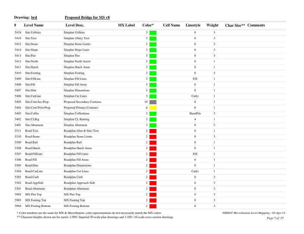
# Level Name Level Desc. MX Label Color* Cell Name Linestyle Comments
brd Proposed Bridge for MS v8Drawing:
Weight Char Size**
35418 Site:Utilities Siteplan Utilities 3 0
35416 Site:Text Siteplan (Only) Text 3 0
35415 Site:Stone Siteplan Stone Limits 3 0
35414 Site:Slope Siteplan Slope Lines 3 0
35413 Site:Pier Siteplan Pier 3 0
15412 Site:North Siteplan North Arrow 3 0
15411 Site:Hatch Siteplan Hatch Areas 3 0
35410 Site:Footing Siteplan Footing 3 0
15409 Site:FillLine Siteplan Fill Lines 3 Fill
15408 Site:Fill Siteplan Fill Areas 3 0
15407 Site:Dim Siteplan Dimensions 3 0
15406 Site:CutLine Siteplan Cut Lines 3 CutLt
15405 Site:Cont:Sec:Prop Proposed Secondary Contours 10 0
15404 Site:Cont:Prim:Prop Proposed Primary Contours 6 0
35403 Site:Coffer Siteplan Cofferdams 3 SheetPile
15402 Site:CLBrg Siteplan CL Bearing 3 4
35401 Site:Abutment Siteplan Abutment 3 0
15311 Road:Text Roadplan (Gen & Site) Text 2 0
35310 Road:Stone Roadplan Stone Limits 2 0
15309 Road:Rail Roadplan Rail 2 0
15308 Road:Hatch Roadplan Hatch Areas 2 0
15307 Road:FillLine Roadplan Fill Lines 2 Fill
15306 Road:Fill Roadplan Fill Areas 2 0
15305 Road:Dim Roadplan Dimensions 2 0
15304 Road:CutLine Roadplan Cut Lines 2 CutLt
35303 Road:Curb Roadplan Curb 2 0
35302 Road:AppSlab Roadplan Approach Slab 2 0
35301 Road:Abutment Roadplan Abutment 2 0
35905 MX Pier Top MX Pier Top 2 0
35903 MX Footing Top MX Footing Top 2 0
35904 MX Footing Bottom MX Footing Bottom 2 0
Page 7 of 57
* Color numbers are the same for MX & MicroStation, color representations do not necessarily match the MX colors
** Character heights shown are for metric 1:500 / Imperial 50-scale plan drawings and 1:100 / 10-scale cross-section drawings
NHDOT MicroStation Level Mapping - 03-Apr-13

# Level Name Level Desc. MX Label Color* Cell Name Linestyle Comments
brd Proposed Bridge for MS v8Drawing:
Weight Char Size**
35901 MX Abutment Top MX Abutment Top 2 0
35902 MX Abutment Bottom MX Abutment Bottom 2 0
35216 Gen:Utilities Genplan Utilities 9 0
15215 Gen:Text Genplan (Only) Text 9 0
35214 Gen:Slope Genplan Slope Lines 9 0
35213 Gen:Rail Genplan Rail 9 0
35212 Gen:Pier Genplan Pier 9 0
15211 Gen:North Genplan North Arrow 9 0
15210 Gen:Hatch Genplan Hatch Areas 9 0
15209 Gen:Fill Genplan Fill Areas 9 0
35208 Gen:ExpJt Genplan Expansion Joint 9 0
15207 Gen:Dim Genplan Dimensions 9 0
35206 Gen:Deck Genplan Deck 9 0
35205 Gen:Curb Genplan Curb 9 0
15204 Gen:ConstChord Genplan Construction Chord 9 4
15203 Gen:CLBrg Genplan CL Bearing 9 4
35202 Gen:Align Genplan Alignment 9 0
35201 Gen:Abutment Genplan Abutment 9 0
15500 Existing:Bridge Existing Bridge 8 0
15105 Detour:Text Detour (Only) Text 6 0
15104 Detour:Slope Detour Slope Lines 6 0
15103 Detour:Dim Detour Dimensions 6 0
15102 Detour:Coffer Detour Cofferdams 6 SheetPile
15101 Detour:Bridge Detour Bridge 6 0
15100 Detour Detour 6 0
15463 Construction Construction Elements 200 0
15417 Borings Boring Layout 2 0
Page 8 of 57
* Color numbers are the same for MX & MicroStation, color representations do not necessarily match the MX colors
** Character heights shown are for metric 1:500 / Imperial 50-scale plan drawings and 1:100 / 10-scale cross-section drawings
NHDOT MicroStation Level Mapping - 03-Apr-13

# Level Name Level Desc. MX Label Color* Cell Name Linestyle Comments
ctr ContoursDrawing:
Weight Char Size**
1350 Intermediate Intermediate 13 3
1348 Index Label Index Label 13 0
2349 Index Index 13 0
0363 Construction Construction Elements 252 5
Page 9 of 57
* Color numbers are the same for MX & MicroStation, color representations do not necessarily match the MX colors
** Character heights shown are for metric 1:500 / Imperial 50-scale plan drawings and 1:100 / 10-scale cross-section drawings
NHDOT MicroStation Level Mapping - 03-Apr-13

# Level Name Level Desc. MX Label Color* Cell Name Linestyle Comments
det DetourDrawing:
Weight Char Size**
33705 WetSum Wetland Impact Summary Chart 105 0
03704 Wetland Legend Wetland Legend 105 0
33703 WetImpLbl Wetland Impact Labels 105 0
33700 WetClsCode Wetland Classification Codes 105 0
33702 Wet Imp Permanent Wetland Impact 105 0
33656 Water und Underground Water 105 Water-Prop
33647 Water shutoff Water Shutoff 105 0
33646 Water gate Water Gate 105 0
33642 W manhole Water Manhole 105 0
33658 Vent Pipe Vent Pipe 105 0
33602 Utility pole note Utility pole note 105 0
33521 Underdrain Underdrain 105 UnderDrain-Prop
33621 Transmission line tower Transmission line tower 105 0
33417 Trail Trail 105 0
03489 Traffic sig Traffic Signal 105 0
33478 Traffic note Traffic Notes 105 0
33406 Traffic Barrels Traffic Barrels 105 TrafBarls
33724 Thru Right Arrow Thru Right Arrow 105 0
33723 Thru Left Arrow Thru Left Arrow 105 0
33720 Thru Arrow Thru Arrow 105 0
33654 Telephone und Underground Telephone 105 Tele-Prop
33641 Tele manhole Telephone Manhole 105 0
33620 Tel pole Telephone Pole 105 0
33752 Taper note Taper Notes 105 0
03503 Strobe Strobe 105 0
33706 Stream Stream 105 Ditch
33450 Stone Wall Stone Wall 105 StoneWall-Prop
43519 Stone Lining Stone Lining Outline 105 0
33619 Span Wire Pole Span Wire Pole 105 0
33425 Sound Wall Posts Sound Wall Posts 105 0
63424 Sound Wall Sound Wall 105 0
Page 10 of 57
* Color numbers are the same for MX & MicroStation, color representations do not necessarily match the MX colors
** Character heights shown are for metric 1:500 / Imperial 50-scale plan drawings and 1:100 / 10-scale cross-section drawings
NHDOT MicroStation Level Mapping - 03-Apr-13

# Level Name Level Desc. MX Label Color* Cell Name Linestyle Comments
det DetourDrawing:
Weight Char Size**
33530 Sluiceway Sluiceway 105 0
33459 Slope Label Slope Line Label 105 0
03502 Signal head Signal head 105 0
33486 Signal conduit Signal conduit 105 ConduitS-Prop
33570 Sign single Single post sign 105 0
33576 Sign Removal Sign Removal Notes 105 0
33569 Sign double Double post sign 105 0
33468 Sig notes Signal Ref Number 105 0
33414 Sidewalk Sidewalk 105 0
33708 ShoreRt Shoreline Right 105 StreamRt
33707 ShoreLt Shoreline Left 105 StreamLt
33447 Shoreline Rt Shoreline Rt 105 StreamRt
33446 Shoreline Lt Shoreline Lt 105 StreamLt
33653 Sewer und Underground Sewer 105 Sewer-Prop
33786 School Symbol School Symbol 105 0
33640 S manhole Sewer Manhole 105 0
33434 ROW Slope ROW Slope 105 Fill
13574 Route Sign Route Sign 105 0
13573 Road Sign Road Sign 105 0
33722 Right Arrow Right Arrow 105 0
33429 Ret wall rt Ret wall rt 105 RetWallRt
33428 Ret wall lt Ret wall lt 105 RetWallLt
33572 Reloc Sign Text Relocated Sign Text 105 0
33528 RCP end section Proposed 60 inch RCP End Section 105 0
33628 Railroad Switch Railroad Switchstand 105 0
33627 Railroad Signal Railroad Signal 105 0
33566 Railroad Sign Railroad Sign 105 0
33422 Railroad Railroad 105 Railroad
33440 Radius Tick Radius Tick 105 0
33616 Pullbox Pullbox 105 0
43701 PropWetlnd Proposed Wetland 105 Wetland
Page 11 of 57
* Color numbers are the same for MX & MicroStation, color representations do not necessarily match the MX colors
** Character heights shown are for metric 1:500 / Imperial 50-scale plan drawings and 1:100 / 10-scale cross-section drawings
NHDOT MicroStation Level Mapping - 03-Apr-13

# Level Name Level Desc. MX Label Color* Cell Name Linestyle Comments
det DetourDrawing:
Weight Char Size**
03500 Preemption Preemption OPTICOM 105 0
33618 Power pole Power Pole 105 0
33609 Pole Pole 105 0
33560 Pipe Flow Arrow Pipe Flow Arrow 105 Arrow
03499 Ped signal Pedestrian signal 105 0
03501 Ped sig pole Pedestrian signal pole 105 0
33419 Ped Rail Pedestrian Guardrail 105 PedRail
53733 Pavement Stripe Pavement Stripe 6 Inch Paintline 105 0
33467 Pavement Removal Notes Pavement Removal Notes 105 0
63442 Pavement Removal Pavement Removal 105 0
33758 Pavement Radius Note Pavement Radius Note 105 0
33750 Pavement Marking Labels Pavement Marking Labels 105 0
33749 Pavement Marking Dimensio Pavement Marking Dimensions 105 0
33738 Pavement Layout Dimension Pavement Layout Dimensions 105 0
33432 Painted Island Painted Island 105 0
33657 Overhead Utility Overhead Utility 105 Electric-OH
33568 Overhead Text Overhead sign structure text 105 0
33567 Overhead Overhead sign structure 105 0
33427 Other fence Other fence 105 Fence-Nobarb
33726 ONLY ONLY 105 0
03577 New signs New signs 105 0
33571 New Sign Text New Sign Text 105 0
43712 Mitigation Hatch Mitigation Area 105 0
33477 Misc note Misc Notes 105 0
03487 Meter Pedestal Meter Pedestal 105 0
33527 Metal end section Proposed 15 inch Metal End Section 105 0
33465 Matchline Quantity Matchline Text 105 0
33488 Mast pole Mast Arm Pole 105 0
33537 Manhole Drainage Manhole 105 0
33484 Magnetic det Magnetic Detector sleeve 105 MagDet
33725 LTR Arrow LTR Arrow 105 0
Page 12 of 57
* Color numbers are the same for MX & MicroStation, color representations do not necessarily match the MX colors
** Character heights shown are for metric 1:500 / Imperial 50-scale plan drawings and 1:100 / 10-scale cross-section drawings
NHDOT MicroStation Level Mapping - 03-Apr-13

# Level Name Level Desc. MX Label Color* Cell Name Linestyle Comments
det DetourDrawing:
Weight Char Size**
33491 Loop Detector Loop Detector 105 0
33630 Lighting notes Lighting Notes 105 0
33613 Light power Power Pole with Light 105 0
33614 Light pole Light Pole 105 0
33612 Light joint Joint Pole with Light 105 0
33649 Light Conduit und Underground Light Conduit 105 Light-Prop
33721 Left Arrow Left Arrow 105 0
33482 Lane markings Lane markings 105 0
03479 Junction box Junction box 105 0
33611 Joint power Joint Pole 105 0
33418 Jersey Barrier Permanent Jersey Barrier 105 JerseyBarrier
33604 ITS Intelligent Transportation Systems 105 ITS-Prop
33510 High point Drainage high point 105 0
33526 Header Header 105 0
33785 Handicap Symbol Handicap Symbol 105 0
33481 Handhole Handhole 105 0
33610 Guy pole Guy or Stub Pole 105 0
33404 Guardrail Notes Guardrail Note 105 0
33415 Guardrail EAGRT 25F Approach Left 105 BmGrLt
33441 Gate Gate 105 0
33652 Gas und Underground Gas 105 Gas-Prop
33645 Gas shutoff Gas shutoff 105 0
33639 G manhole Gas manhole 105 0
33644 Fire hydrant Fire Hydrant 105 0
33651 Fire Alarm und Underground Fire Alarm 105 Fire-Prop
33437 Fill slope Fill slope 105 Fill
33606 Fiber Optics Fiber Optics 105 FiberOptic-Prop
33476 Fence note Fence Notes 105 0
33650 Electric und Underground Electric 105 Electric-Prop
33411 Edge of trav Edge of Traveled Way 105 0
33410 Edge of pave Edge of Pavement 105 0
Page 13 of 57
* Color numbers are the same for MX & MicroStation, color representations do not necessarily match the MX colors
** Character heights shown are for metric 1:500 / Imperial 50-scale plan drawings and 1:100 / 10-scale cross-section drawings
NHDOT MicroStation Level Mapping - 03-Apr-13

# Level Name Level Desc. MX Label Color* Cell Name Linestyle Comments
det DetourDrawing:
Weight Char Size**
33409 Edge of Lane Edge of Lane 105 0
33439 Earthworks General Earthworks General 105 0
33638 E manhole Electric Manhole 105 0
33727 Dual Left Arrow Dual Left Arrow 105 0
33536 Drop inlet Drop inlet 105 0
33416 Driveway Driveway 105 0
33755 Drive note Drive note 105 0
33754 Drive Dimensions Drive Dimensions 105 0
33520 Drain pipe 300mm 105 PipeP12
33548 Drain note Drainage notes 105 0
33532 Ditch line Ditch line 105 Ditch
33474 Demo note Const Demolition Notes Constr 105 0
33473 Demo note Demolition Notes ROW 105 0
33436 Cut Slope rt Cut Slope Right 105 CutRt
33435 Cut Slope lt Cut Slope Left 105 CutLt
33431 Curbed Island Curbed Island 105 0
33430 Curb Top Curb Top Left 105 PCurbLt
33736 Curb Mark Number Curb Mark Number 105 0
33412 Curb Bottom Curb Bottom 105 0
03480 Ctrlr cab Controller Cabinet 105 0
33433 Construction Slope Construction Slope 105 Fill
03578 Construction Construction Elements 105 5
03575 Const signs Const signs G20 105 0
43464 Const Plan Limits End Approach Leader Line 105 ArEndSld
33469 Const notes Construction Notes 105 0
33438 Clearing Line Clearing Line 105 0
33458 Clearing Label Clearing Line Label 105 0
33471 Clearing Areas Clearing Area Symbol 105 0
33534 Catch Basin Catch Basin 105 0
33655 Cable TV und Underground Cable TV 105 CATV
63443 Building Removal Building Removal 105 0
Page 14 of 57
* Color numbers are the same for MX & MicroStation, color representations do not necessarily match the MX colors
** Character heights shown are for metric 1:500 / Imperial 50-scale plan drawings and 1:100 / 10-scale cross-section drawings
NHDOT MicroStation Level Mapping - 03-Apr-13

# Level Name Level Desc. MX Label Color* Cell Name Linestyle Comments
det DetourDrawing:
Weight Char Size**
03444 Bridge Removal Bridge Removal 0 0
33413 Bridge rail Bridge approach rail 105 0
33472 Bridge notes Bridge Notes 105 0
33405 Boulder Boulder 105 0
33420 Bike Rail Bike Rail 105 0
33426 Barbed wire fence Barbed Wire Fence short 105 Fence-Barbed(short)
Page 15 of 57
* Color numbers are the same for MX & MicroStation, color representations do not necessarily match the MX colors
** Character heights shown are for metric 1:500 / Imperial 50-scale plan drawings and 1:100 / 10-scale cross-section drawings
NHDOT MicroStation Level Mapping - 03-Apr-13
# Level Name Level Desc. MX Label Color* Cell Name Linestyle Comments
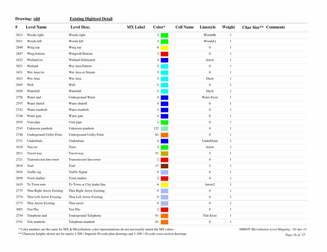
edd Existing Digitized DetailDrawing:
Weight Char Size**
13012 Woods right Woods right 3 WoodsRt
13011 Woods left Woods left 3 WoodsLt
12848 Wing top Wing top 6 0
12847 Wing bottom Wingwall Bottom 2 0
11632 Wetland txt Wetland Delineated 4 Arrow
13021 Wetland Wet Area Pattern 5 0
11631 Wet Area txt Wet Area or Stream 5 0
13023 Wet Area Wet Area 5 Ditch
12945 Well Well 5 0
13020 Waterfall Waterfall 5 Ditch
12756 Water und Underground Water 4 Water-Exist
12747 Water shutof Water shutoff 4 0
12742 Water manhole Water manhole 4 0
12746 Water gate Water gate 4 0
12935 Vent pipe Vent pipe 3 0
12743 Unknown manhole Unknown manhole 122 0
12748 Underground Utility Point Underground Utility Point 81 0
12731 Underdrain Underdrain 4 UnderDrain
11610 Tree txt Trees 3 Arrow
12811 Travel way Travel way 51 5
12721 Transmission line tower Transmission line tower 2 0
12818 Trail Trail 17 5
12916 Traffic sig Traffic Signal 9 0
12858 Town marker Town marker 2 0
11619 To Town note To Town or City leader line 6 Arrow2
12775 Thru Right Arrow Existing Thru Right Arrow Existing 9 0
12774 Thru Left Arrow Existing Thru Left Arrow Existing 9 0
12773 Thru Arrow Existing Thru arrow 9 0
13003 Test Pits Test Pits 2 0
12754 Telephone und Underground Telephone 81 Tele-Exist
12741 Tele manhole Telephone manhole 81 0
Page 16 of 57
* Color numbers are the same for MX & MicroStation, color representations do not necessarily match the MX colors
** Character heights shown are for metric 1:500 / Imperial 50-scale plan drawings and 1:100 / 10-scale cross-section drawings
NHDOT MicroStation Level Mapping - 03-Apr-13

# Level Name Level Desc. MX Label Color* Cell Name Linestyle Comments
edd Existing Digitized DetailDrawing:
Weight Char Size**
12720 Tel pole Telephone pole 81 0
12952 Tank Fill Storage Tank Fill Cap 6 0
13022 Swamp symbol Swamp symbol 5 0
13008 Stump Stump 3 0
11620 Structure txt Structures leader line 96 Arrow
12910 Street Light Conduit Street Light Conduit 2 Light-Exist
13016 Stream Stream 5 Ditch
12953 Storage Tank Storage Tank 6 0
12832 Stone wall Stone wall 96 StoneWall-Exist
12934 Stockpile Stockpile 161 0
13028 Steps Steps 2 0
12856 State marker State marker 2 0
12803 Spot Survey Elev Elevation Point Survey 2 0
12959 Splice Vault Splice Vault 6 0
12831 Sound Wall Sound Wall 40 0
12944 Sluiceway Sluiceway 5 5
03024 Sill point Sill point 2 0
12909 Signal conduit Signal conduit 9 ConduitS
12955 Sign Var Speed Limit Sign Var Speed Limit 9 0
11615 Sign txt Signs 9 Arrow
12915 Sign single Sign single 9 0
12956 Sign FOD Sign FOD 9 0
12914 Sign double Sign double 9 0
12815 Sidewalk Sidewalk 9 5
13018 Shore right Shore right 5 StreamRt
13017 Shore left Shore left 5 StreamLt
12753 Sewer und Underground Sewer 3 Sewer-Exist
12740 Sewer manhole Sewer manhole 3 0
12933 Septic Tank Septic Tank 3 0
12838 Scupper Scupper 4 0
12932 Sat dish Satellite dish 122 0
Page 17 of 57
* Color numbers are the same for MX & MicroStation, color representations do not necessarily match the MX colors
** Character heights shown are for metric 1:500 / Imperial 50-scale plan drawings and 1:100 / 10-scale cross-section drawings
NHDOT MicroStation Level Mapping - 03-Apr-13

# Level Name Level Desc. MX Label Color* Cell Name Linestyle Comments
edd Existing Digitized DetailDrawing:
Weight Char Size**
12728 RR switch Railroad switchstand 150 0
12727 RR Signal Railroad signal 150 0
12726 RR sign Railroad sign 150 0
13042 Rock outcrop Rock outcrop Right 173 RockRt
21611 Road Names Road Names 6 0
12961 Road n Weather Info Sys Road n Weather Info Sys 6 0
02801 Road Center Road Center 6 0
21618 River Names River Names 6 0
13041 Riprap Riprap 173 5
12772 Right Arrow Existing Right arrow 9 0
12834 Ridge line Ridge line 96 5
12830 Ret wall top Ret wall top 6 0
12829 Ret wall rt Ret wall rt 96 RetWallRt
12828 Ret wall lt Ret wall lt 96 RetWallLt
12943 Ramp Ramp 5 0
12725 Railroad Railroad 150 Railroad
12908 Pullbox Pullbox 9 0
12722 Public tele Public telephone 81 0
12854 Proj marker Proj marker 2 0
21604 Prelim Stamp Prelim Plan Stamp 2 0
12718 Power pole Power Pole 2 0
12713 Power light Power light pole 2 0
12930 Post Post 15 0
12929 Pool Pool 5 0
11616 Pole txt Poles 161 Arrow
12717 Pole Pole 2 0
12760 Planprep Planprep 0 0
01603 Plan Prep Stamp Plan Prep Stamp 2 0
11630 Pipe txt Pipes 4 Arrow
12846 Pier top Pier top 6 0
01608 Photo Photo Location 2 0
Page 18 of 57
* Color numbers are the same for MX & MicroStation, color representations do not necessarily match the MX colors
** Character heights shown are for metric 1:500 / Imperial 50-scale plan drawings and 1:100 / 10-scale cross-section drawings
NHDOT MicroStation Level Mapping - 03-Apr-13
# Level Name Level Desc. MX Label Color* Cell Name Linestyle Comments
edd Existing Digitized DetailDrawing:
Weight Char Size**
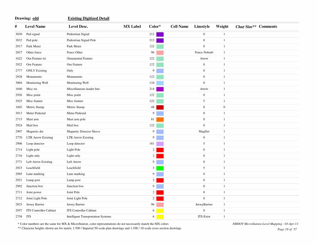
13030 Ped signal Pedestrian Signal 212 0
13032 Ped pole Pedestrian Signal Pole 212 0
12917 Park Meter Park Meter 122 0
12827 Other fence Fence Other 96 Fence-Nobarb
11622 Orn Feature txt Ornamental Feature 122 Arrow
12922 Orn Feature Orn Feature 122 0
12777 ONLY Existing Only 9 0
12928 Monuments Monuments 122 0
13004 Monitoring Well Monitoring Well 110 0
11640 Misc txt Miscellaneous leader line 214 Arrow
12926 Misc point Misc point 122 0
12925 Misc feature Misc feature 122 5
01602 Metric Stamp Metric Stamp 48 0
13013 Meter Pedestal Meter Pedestal 9 0
12715 Mast arm Mast arm pole 81 0
12924 Mail box Mail box 122 0
12907 Magnetic det Magnetic Detector Sleeve 9 MagDet
12770 LTR Arrow Existing LTR Arrow Existing 9 0
12906 Loop detector Loop detector 181 5
12714 Light pole Light Pole 2 0
12716 Light only Light only 2 0
12771 Left Arrow Existing Left Arrow 9 0
12923 Leachfield Leachfield 3 5
12905 Lane marking Lane marking 9 0
12921 Lamp post Lamp post 2 0
12902 Junction box Junction box 9 0
12711 Joint power Joint Pole 2 0
12712 Joint Light Pole Joint Light Pole 2 0
12825 Jersey Barrier Jersey Barrier 96 JerseyBarrier
12957 ITS Controller Cabinet ITS Controller Cabinet 6 0
12758 ITS Intelligent Transportation Systems 6 ITS-Exist
Page 19 of 57
* Color numbers are the same for MX & MicroStation, color representations do not necessarily match the MX colors
** Character heights shown are for metric 1:500 / Imperial 50-scale plan drawings and 1:100 / 10-scale cross-section drawings
NHDOT MicroStation Level Mapping - 03-Apr-13

# Level Name Level Desc. MX Label Color* Cell Name Linestyle Comments
edd Existing Digitized DetailDrawing:
Weight Char Size**
12853 Iron pin Iron pin 2 0
13015 High water High water 5 5
13006 Hedge Hedge 3 Hedge
22732 Header Header Top 4 0
12904 Handhole Handhole 9 0
12709 Guy wire anc Guy wire anchor 2 0
12710 Guy pole Guy pole 2 0
11621 Guardrail txt Guardrail 96 Arrow
12820 Guardrail Cable Guardrail Right 96 CblGrRt
12920 Ground light Ground light 2 0
13052 Gravestone Gravestone 15 0
11605 General txt General leader line 3 Arrow
12919 Gate post Gate post 96 0
12936 Gate Gate 96 0
12752 Gas und Underground Gas 6 Gas-Exist
12745 Gas shutoff Gas shutoff 6 0
12951 Gas Pumps Gas Pumps 6 0
12949 Gas pump Gas pump 6 0
12739 Gas manhole Gas manhole 6 0
12954 Fuel Tank Fuel Tank 6 0
13026 Foundation Foundation 2 5
12845 Footing Top Footing Top 6 0
12844 Footing Bottom Footing Bottom 2 0
12729 Flushing Basin Flushing Basin 4 0
11613 Flow arrow River Flow Arrow 5 0
12918 Flag pole Flag pole 122 0
12744 Fire hydrant Fire hydrant 4 0
12751 Fire Alarm und Underground Fire Alarm 81 Fire-Exist
21641 Field Check txt Field Check 19 Arrow
12757 Fiber Optics und Underground Fiber Optics 6 FiberOptic-Exist
11627 Fence txt Fence 96 Arrow
Page 20 of 57
* Color numbers are the same for MX & MicroStation, color representations do not necessarily match the MX colors
** Character heights shown are for metric 1:500 / Imperial 50-scale plan drawings and 1:100 / 10-scale cross-section drawings
NHDOT MicroStation Level Mapping - 03-Apr-13

# Level Name Level Desc. MX Label Color* Cell Name Linestyle Comments
edd Existing Digitized DetailDrawing:
Weight Char Size**
12843 Exp joint Expansion joint 2 5
12733 End section Existing End Section 4 0
12750 Electric und Underground Electric 2 Electric-Exist
12738 Electric manhole Electric manhole 2 0
12810 Edge of pave Edge of Pavement 100 5
12809 Edge of Gravel Road Edge of Gravel Road 10 5
12960 Dynamic Message Sign Dynamic Message Sign 6 0
12778 Dual Left Arrow Existing Dual Left Arrow 9 0
12736 Drop inlet Drop inlet 4 0
11617 Driveway txt Driveway leader line 81 Arrow
12817 Driveway Driveway 81 5
12849 Drill hole Drill hole 2 0
12737 Drainage manhole Drainage manhole 4 0
12730 Drain pipe 1650mm 4 PipeE48
12816 Ditch line Ditch line 5 0
00 Default 0 0
13010 Decid Tree Decid Tree 3 0
12942 Dam bottom Dam bottom 5 0
12941 Dam Dam 6 0
12814 Curb Top Curb Top 100 5
12813 Curb Right Curb Right 100 CurbRt
12812 Curb Left Curb Left 100 CurbLt
12903 Ctrlr cab Controller cabinet 9 1
02763 Construction Construction Elements 252 5
13009 Conif Tree Conif Tree 3 0
12950 Concrete Pad Concrete Pad 122 0
13051 Cemetery Cemetery 15 5
12735 CB sump CB/DI Sump text 4 0
12734 Catch Basin Catch Basin 4 0
12958 Camera Pole Camera Pole 6 0
12755 Cable TV und Underground Cable TV 81 CATV
Page 21 of 57
* Color numbers are the same for MX & MicroStation, color representations do not necessarily match the MX colors
** Character heights shown are for metric 1:500 / Imperial 50-scale plan drawings and 1:100 / 10-scale cross-section drawings
NHDOT MicroStation Level Mapping - 03-Apr-13

# Level Name Level Desc. MX Label Color* Cell Name Linestyle Comments
edd Existing Digitized DetailDrawing:
Weight Char Size**
13005 Bush Bush 3 0
11625 Building txt Building leader line 2 Arrow
13025 Building sill Building sill 2 0
13027 Building Building 2 0
12842 Bridge deck Bridge deck 2 0
12931 Br Misc point Bridge Misc point 122 0
12851 Bound other Bound other 2 0
12852 Bound Bound 2 0
13040 Boulder Boulder 173 0
13002 Boring Boring 2 0
12913 Billboard Billboard 9 0
12940 Berm Berm 17 Berm
12850 Bench mark Bench mark 2 0
12826 Barbed fence Barbed Wire short 96 Fence-Barbed(short)
13050 Ath field Ath field 3 0
12701 Arch bottom Arch bottom 2 0
12749 Aerial Electric Aerial Electric 2 Electric-OH
12841 Abut top Abut top 6 0
12840 Abut bottom Abutment Bottom 2 0
Page 22 of 57
* Color numbers are the same for MX & MicroStation, color representations do not necessarily match the MX colors
** Character heights shown are for metric 1:500 / Imperial 50-scale plan drawings and 1:100 / 10-scale cross-section drawings
NHDOT MicroStation Level Mapping - 03-Apr-13

# Level Name Level Desc. MX Label Color* Cell Name Linestyle Comments
edu Existing digitized utilitiesDrawing:
Weight Char Size**
12156 Water und Water und 4 Water-Exist
12147 Water shutof Water shutof 4 0
12742 Water manhole Water manhole 4 0
12146 Water gate Water gate 4 0
12142 W manhole W manhole 4 0
12108 Utility Text Utility Text 2 0
12107 Utility Note Utility Note 252 0
12743 Unknown manhole Unknown manhole 122 0
12748 Underground Utility Point Underground Utility Point 81 0
12131 Underdrain Underdrain 4 UnderDrain
12721 Transmission line tower Transmission line tower 2 0
12121 Transmission Transmission line tower 2 Electric-OH
12106 Traffic Text Traffic Text 6 0
12916 Traffic sig Traffic Signal 9 0
11114 Thru Right Arrow Existing Thru Right Arrow Existing 9 0
11110 Thru Arrow Existing Thru arrow 9 0
12154 Telephone und Telephone und 81 Tele-Exist
12741 Tele manhole Telephone manhole 81 0
12120 Tel pole Tel pole 81 0
12141 T manhole T manhole 81 0
12910 SWZ SWZ 122 0
12959 Splice Vault Splice Vault 6 0
12119 Span wire Span Wire Pole 2 0
12909 Signal conduit Signal conduit 9 0
12955 Sign Var Speed Limit Sign Var Speed Limit 9 0
12915 Sign single Sign single 9 0
12956 Sign FOD Sign FOD 9 0
12914 Sign double Sign double 9 0
12153 Sewer und Sewer und 3 Sewer-Exist
12740 Sewer manhole Sewer manhole 3 0
12140 S manhole S manhole 3 0
Page 23 of 57
* Color numbers are the same for MX & MicroStation, color representations do not necessarily match the MX colors
** Character heights shown are for metric 1:500 / Imperial 50-scale plan drawings and 1:100 / 10-scale cross-section drawings
NHDOT MicroStation Level Mapping - 03-Apr-13

# Level Name Level Desc. MX Label Color* Cell Name Linestyle Comments
edu Existing digitized utilitiesDrawing:
Weight Char Size**
12128 RR switch RR switch 150 0
12127 RR Signal RR Signal 150 0
12126 RR sign RR sign 150 0
11112 Right Arrow Existing Right arrow 9 0
12125 Railroad Railroad 150 Railroad
12908 Pullbox Pullbox 9 0
12122 Public tele Public tele 81 0
12118 Power pole Power pole 2 0
12113 Power light Power light 2 0
12117 Pole Pole 2 0
13030 Ped signal Pedestrian Signal 212 0
13032 Ped pole Pedestrian Signal Pole 212 0
12917 Park Meter Park Meter 122 0
11116 ONLY Existing Only 9 0
13013 Meter post Meter Post 9 0
12115 Mast arm Mast arm 81 0
02159 Magnetic det Magnetic det 9 0
11115 LTR Arrow Existing LTR Arrow Existing 9 0
31125 LTR Arrow LTR Arrow 212 0
02906 Loop Detector Loop Detector 181 0
12114 Light pole Light pole 2 0
11111 Left Arrow Existing Left Arrow 9 0
02905 Lane marking Lane marking 9 0
02902 Junction box Junction box 9 0
12111 Joint power Joint power 2 0
12112 Joint light Joint light 2 0
12957 ITS Controller Cabinet ITS Controller Cabinet 6 0
12758 ITS Intelligent Transportation Systems 6 ITS-Exist
22132 Header Header 4 0
12109 Guy wire anc Guy wire anc 2 0
12110 Guy pole Guy pole 2 0
Page 24 of 57
* Color numbers are the same for MX & MicroStation, color representations do not necessarily match the MX colors
** Character heights shown are for metric 1:500 / Imperial 50-scale plan drawings and 1:100 / 10-scale cross-section drawings
NHDOT MicroStation Level Mapping - 03-Apr-13

# Level Name Level Desc. MX Label Color* Cell Name Linestyle Comments
edu Existing digitized utilitiesDrawing:
Weight Char Size**
12152 Gas und Gas und 6 Gas-Exist
12145 Gas shutoff Gas shutoff 6 0
12739 Gas manhole Gas manhole 6 0
12139 G manhole G manhole 6 0
12144 Fire hydrant Fire hydrant 4 0
12151 Fire Alarm Underground Fire Alarm 81 Fire-Exist
12133 End section Existing End Section 4 0
12150 Electric und Electric und 2 Electric-Exist
12738 Electric manhole Electric manhole 2 0
12138 E manhole E manhole 2 0
11117 Dual Left Arrow Existing Dual Left Arrow 9 0
12136 Drop inlet Drop inlet 4 0
12737 Drainage manhole Drainage manhole 4 0
12130 Drain pipe Existing Drainage 4 PipeE48
00 Default 0 0
12137 D manhole D manhole 4 0
02903 Ctrlr cab Ctrlr cab 9 0
02163 Construction Construction Elements 252 5
12135 CB sump Catch basin Drop inlet sump 4 0
12134 Catch basin Catch basin 4 0
12911 Camera Pole Camera Pole 6 0
12155 Cable Underground Cable TV 81 0
12149 Aerial util Aerial util 2 Electric-OH
Page 25 of 57
* Color numbers are the same for MX & MicroStation, color representations do not necessarily match the MX colors
** Character heights shown are for metric 1:500 / Imperial 50-scale plan drawings and 1:100 / 10-scale cross-section drawings
NHDOT MicroStation Level Mapping - 03-Apr-13

# Level Name Level Desc. MX Label Color* Cell Name Linestyle Comments
env EnvironmentDrawing:
Weight Char Size**
0611 Wetland Legend Wetland Legend 110 0
2621 Wetland Labels Wetland Delineated Labels 110 0
2620 Wetland Wetland Delineated 4 Wetland
2647 Waterfront Buffer 50 ft Waterfront Buffer 110 WB50
2645 Vernal Pool Vernal Pool 110 VP
2634 TOBOHW TOBOHW 110 TOBOHW
2633 TOB Top Of Bank 110 TOB
2632 TBZ Tidal Buffer Zone 110 TBZ
0622 Swamp Symbol Swamp Symbol 5 0
2644 Special Aquatic Site Special Aquatic Site 110 SAS
2604 Shore Land Reference Line Shore Land Reference Line 110 REF
2650 Protected Shore Land 250 ft Protected Shore Land 110 PS250
2642 Prime Wetland Prime Wetland 110 PWET
0605 Potential Historic Label Potential Historic Structure label 2 0
2631 OHW Ordinary High Water 110 OHW
2636 OHT Ordinary High Tide 110 OHT
2648 Natural Woodland Buffer 150 ft Natural Woodland Buffer 110 NWB150
2635 MHT Mean High Tide 110 MHT
2640 LCIP Easement LCIP Conservation Easement 3 1
2628 Invasive Species Invasive Species Type II 42 0
2630 HOTL Highest Observable Tidal Line 110 HOTL
2602 Historic Property Historic Property bndy 2 0
0603 Historic Label Historic Structure label 2 0
2601 Historic District Historic District bndy 2 0
2614 Floodway Floodway Label 214 FW
2618 Floodplain Label Floodplain Label 214 0
2617 Floodplain 500 year Floodplain 500 year 214 FP500
2616 Floodplain 100 year Floodplain 100 year 214 FP100
0663 Construction Construction Elements 252 5
Page 26 of 57
* Color numbers are the same for MX & MicroStation, color representations do not necessarily match the MX colors
** Character heights shown are for metric 1:500 / Imperial 50-scale plan drawings and 1:100 / 10-scale cross-section drawings
NHDOT MicroStation Level Mapping - 03-Apr-13

# Level Name Level Desc. MX Label Color* Cell Name Linestyle Comments
erl Existing Right-of-Way LinesDrawing:
Weight Char Size**
12507 ZProperty line ZProperty Line 15 ZPropLine
12543 Town line Town line 2 TownLine
12541 State line State line 2 StateLine
12506 Property line Property line 15 PropLine
12540 National Forest National Forest 2 NtnlForest
12511 Ex RRROW Ex RRROW 94 RRROW
12515 Ex ROW Ex ROW 94 ROW
12514 Ex MUT ROW Ex MUTROW 82 RRROW
12510 Ex LAROW Ex LAROW 2 ROW
12512 Ex Ease Easement Line Existing 82 5
12509 Ex CAROW Ex CAROW 3 ROW
12542 County line County line 2 County
02563 Construction Construction Elements 252 5
Page 27 of 57
* Color numbers are the same for MX & MicroStation, color representations do not necessarily match the MX colors
** Character heights shown are for metric 1:500 / Imperial 50-scale plan drawings and 1:100 / 10-scale cross-section drawings
NHDOT MicroStation Level Mapping - 03-Apr-13

# Level Name Level Desc. MX Label Color* Cell Name Linestyle Comments
ert Existing Right-of-Way TextDrawing:
Weight Char Size**
14501 Tax Map Number Tax Map text 216 0
14520 ROW Label ROW Label 94 0
14527 ROW Flag ROW Flag 94 0
14504 Property Owner Property Owner 94 0
14503 Parcel number Parcel Number 94 0
14510 Easement Label Easement Label 82 0
04563 Construction Construction Elements 252 5
14545 Civil Names Civil Boundary Names 15 0
14502 Abstract Note Abstract Note cell 216 0
Page 28 of 57
* Color numbers are the same for MX & MicroStation, color representations do not necessarily match the MX colors
** Character heights shown are for metric 1:500 / Imperial 50-scale plan drawings and 1:100 / 10-scale cross-section drawings
NHDOT MicroStation Level Mapping - 03-Apr-13

# Level Name Level Desc. MX Label Color* Cell Name Linestyle Comments
exd Existing Detail v8Drawing:
Weight Char Size**
13012 Woods right Woods right 3 WoodsRt
13011 Woods left Woods left 3 WoodsLt
12848 Wing top Wing top 6 0
12847 Wing bottom Wingwall Bottom 2 0
13021 Wetland Wet Area Pattern 5 0
13023 Wet Area Wet Area 5 Ditch
12945 Well Well 5 0
13020 Waterfall Waterfall 5 Ditch
12756 Water und Underground Water 4 Water-Exist
12747 Water shutof Water shutoff 4 0
12742 Water manhole Water manhole 4 0
12746 Water gate Water gate 4 0
12935 Vent pipe Vent pipe 3 0
12743 Unknown manhole Unknown manhole 122 0
12748 Underground Utility Point Underground Utility Point 81 0
12731 Underdrain Underdrain 4 UnderDrain
12811 Travel way Travel way 51 5
12721 Transmission line tower Transmission line tower 2 0
12818 Trail Trail 17 5
12916 Traffic sig Traffic Signal 9 0
12858 Town marker Town marker 2 0
12775 Thru Right Arrow Existing Thru Right Arrow Existing 9 0
12774 Thru Left Arrow Existing Thru Left Arrow Existing 9 0
12773 Thru Arrow Existing Thru arrow 9 0
13003 Test Pits Test Pits 2 0
12754 Telephone und Underground Telephone 81 Tele-Exist
12741 Tele manhole Telephone manhole 81 0
12720 Tel pole Telephone pole 81 0
12952 Tank Fill Storage Tank Fill Cap 6 0
13022 Swamp symbol Swamp symbol 5 0
13008 Stump Stump 3 0
Page 29 of 57
* Color numbers are the same for MX & MicroStation, color representations do not necessarily match the MX colors
** Character heights shown are for metric 1:500 / Imperial 50-scale plan drawings and 1:100 / 10-scale cross-section drawings
NHDOT MicroStation Level Mapping - 03-Apr-13

# Level Name Level Desc. MX Label Color* Cell Name Linestyle Comments
exd Existing Detail v8Drawing:
Weight Char Size**
12910 Street Light Conduit Street Light Conduit 2 Light-Exist
13016 Stream Stream 5 Ditch
12953 Storage Tank Storage Tank 6 0
12832 Stone wall Stone wall 96 StoneWall-Exist
12934 Stockpile Stockpile 161 0
13028 Steps Steps 2 0
12856 State marker State marker 2 0
12803 Spot Survey Elev Elevation Point Survey 2 0
12959 Splice Vault Splice Vault 6 0
12831 Sound Wall Sound Wall 40 0
12944 Sluiceway Sluiceway 5 5
03024 Sill point Sill point 2 0
12909 Signal conduit Signal conduit 9 ConduitS
12955 Sign Var Speed Limit Sign Var Speed Limit 9 0
12915 Sign single Sign single 9 0
12956 Sign FOD Sign FOD 9 0
12914 Sign double Sign double 9 0
12815 Sidewalk Sidewalk 9 5
13018 Shore right Shore right 5 StreamRt
13017 Shore left Shore left 5 StreamLt
12753 Sewer und Underground Sewer 3 Sewer-Exist
12740 Sewer manhole Sewer manhole 3 0
12933 Septic Tank Septic Tank 3 0
12838 Scupper Scupper 4 0
12932 Sat dish Satellite dish 122 0
12728 RR switch Railroad switchstand 150 0
12727 RR Signal Railroad signal 150 0
12726 RR sign Railroad sign 150 0
13042 Rock outcrop Rock outcrop Right 173 RockRt
12961 Road n Weather Info Sys Road n Weather Info Sys 6 0
02801 Road Center Road Center 6 0
Page 30 of 57
* Color numbers are the same for MX & MicroStation, color representations do not necessarily match the MX colors
** Character heights shown are for metric 1:500 / Imperial 50-scale plan drawings and 1:100 / 10-scale cross-section drawings
NHDOT MicroStation Level Mapping - 03-Apr-13

# Level Name Level Desc. MX Label Color* Cell Name Linestyle Comments
exd Existing Detail v8Drawing:
Weight Char Size**
13041 Riprap Riprap 173 5
12772 Right Arrow Existing Right arrow 9 0
12834 Ridge line Ridge line 96 5
12830 Ret wall top Ret wall top 6 0
12829 Ret wall rt Ret wall rt 96 RetWallRt
12828 Ret wall lt Ret wall lt 96 RetWallLt
12943 Ramp Ramp 5 0
12725 Railroad Railroad 150 Railroad
12908 Pullbox Pullbox 9 0
12722 Public tele Public telephone 81 0
12854 Proj marker Proj marker 2 0
12718 Power pole Power Pole 2 0
12713 Power light Power light pole 2 0
12930 Post Post 15 0
12929 Pool Pool 5 0
12717 Pole Pole 2 0
12760 Planprep Planprep 0 0
12846 Pier top Pier top 6 0
13030 Ped signal Pedestrian Signal 212 0
13032 Ped pole Pedestrian Signal Pole 212 0
12917 Park Meter Park Meter 122 0
12827 Other fence Fence Other 96 Fence-Nobarb
12922 Orn Feature Orn Feature 122 0
12777 ONLY Existing Only 9 0
12928 Monuments Monuments 122 0
13004 Monitoring Well Monitoring Well 110 0
12926 Misc point Misc point 122 0
12925 Misc feature Misc feature 122 5
13013 Meter Pedestal Meter Pedestal 9 0
12715 Mast arm Mast arm pole 81 0
12924 Mail box Mail box 122 0
Page 31 of 57
* Color numbers are the same for MX & MicroStation, color representations do not necessarily match the MX colors
** Character heights shown are for metric 1:500 / Imperial 50-scale plan drawings and 1:100 / 10-scale cross-section drawings
NHDOT MicroStation Level Mapping - 03-Apr-13

# Level Name Level Desc. MX Label Color* Cell Name Linestyle Comments
exd Existing Detail v8Drawing:
Weight Char Size**
12907 Magnetic det Magnetic Detector Sleeve 9 MagDet
12770 LTR Arrow Existing LTR Arrow Existing 9 0
12906 Loop detector Loop detector 181 5
12714 Light pole Light Pole 2 0
12716 Light only Light only 2 0
12771 Left Arrow Existing Left Arrow 9 0
12923 Leachfield Leachfield 3 5
12905 Lane marking Lane marking 9 0
12921 Lamp post Lamp post 2 0
12902 Junction box Junction box 9 0
12711 Joint power Joint Pole 2 0
12712 Joint Light Pole Joint Light Pole 2 0
12825 Jersey Barrier Jersey Barrier 96 JerseyBarrier
12957 ITS Controller Cabinet ITS Controller Cabinet 6 0
12758 ITS Intelligent Transportation Systems 6 ITS-Exist
12853 Iron pin Iron pin 2 0
13015 High water High water 5 5
13006 Hedge Hedge 3 Hedge
22732 Header Header Top 4 0
12904 Handhole Handhole 9 0
12709 Guy wire anc Guy wire anchor 2 0
12710 Guy pole Guy pole 2 0
12820 Guardrail Cable Guardrail Right 96 CblGrRt
12920 Ground light Ground light 2 0
13052 Gravestone Gravestone 15 0
12919 Gate post Gate post 96 0
12936 Gate Gate 96 0
12752 Gas und Underground Gas 6 Gas-Exist
12745 Gas shutoff Gas shutoff 6 0
12951 Gas Pumps Gas Pumps 6 0
12949 Gas pump Gas pump 6 0
Page 32 of 57
* Color numbers are the same for MX & MicroStation, color representations do not necessarily match the MX colors
** Character heights shown are for metric 1:500 / Imperial 50-scale plan drawings and 1:100 / 10-scale cross-section drawings
NHDOT MicroStation Level Mapping - 03-Apr-13

# Level Name Level Desc. MX Label Color* Cell Name Linestyle Comments
exd Existing Detail v8Drawing:
Weight Char Size**
12739 Gas manhole Gas manhole 6 0
12954 Fuel Tank Fuel Tank 6 0
13026 Foundation Foundation 2 5
12845 Footing Top Footing Top 6 0
12844 Footing Bottom Footing Bottom 2 0
12729 Flushing Basin Flushing Basin 4 0
12918 Flag pole Flag pole 122 0
12744 Fire hydrant Fire hydrant 4 0
12751 Fire Alarm und Underground Fire Alarm 81 Fire-Exist
12757 Fiber Optics und Underground Fiber Optics 6 FiberOptic-Exist
12843 Exp joint Expansion joint 2 5
12733 End section Existing End Section 4 0
12750 Electric und Underground Electric 2 Electric-Exist
12738 Electric manhole Electric manhole 2 0
12810 Edge of pave Edge of Pavement 100 5
12809 Edge of Gravel Road Edge of Gravel Road 10 5
12960 Dynamic Message Sign Dynamic Message Sign 6 0
12778 Dual Left Arrow Existing Dual Left Arrow 9 0
12736 Drop inlet Drop inlet 4 0
12817 Driveway Driveway 81 5
12849 Drill hole Drill hole 2 0
12737 Drainage manhole Drainage manhole 4 0
12730 Drain pipe 1650mm 4 PipeE48
12816 Ditch line Ditch line 5 0
00 Default 0 0
13010 Decid Tree Decid Tree 3 0
12942 Dam bottom Dam bottom 5 0
12941 Dam Dam 6 0
12814 Curb Top Curb Top 100 5
12813 Curb Right Curb Right 100 CurbRt
12812 Curb Left Curb Left 100 CurbLt
Page 33 of 57
* Color numbers are the same for MX & MicroStation, color representations do not necessarily match the MX colors
** Character heights shown are for metric 1:500 / Imperial 50-scale plan drawings and 1:100 / 10-scale cross-section drawings
NHDOT MicroStation Level Mapping - 03-Apr-13

# Level Name Level Desc. MX Label Color* Cell Name Linestyle Comments
exd Existing Detail v8Drawing:
Weight Char Size**
12903 Ctrlr cab Controller cabinet 9 1
02763 Construction Construction Elements 252 5
13009 Conif Tree Conif Tree 3 0
12950 Concrete Pad Concrete Pad 122 0
13051 Cemetery Cemetery 15 5
12735 CB sump CB/DI Sump text 4 0
12734 Catch Basin Catch Basin 4 0
12958 Camera Pole Camera Pole 6 0
12755 Cable TV und Underground Cable TV 81 CATV
13005 Bush Bush 3 0
13025 Building sill Building sill 2 0
13027 Building Building 2 0
12842 Bridge deck Bridge deck 2 0
12931 Br Misc point Bridge Misc point 122 0
12851 Bound other Bound other 2 0
12852 Bound Bound 2 0
13040 Boulder Boulder 173 0
13002 Boring Boring 2 0
12913 Billboard Billboard 9 0
12940 Berm Berm 17 Berm
12850 Bench mark Bench mark 2 0
12826 Barbed fence Barbed Wire short 96 Fence-Barbed(short)
13050 Ath field Ath field 3 0
12701 Arch bottom Arch bottom 2 0
12749 Aerial Electric Aerial Electric 2 Electric-OH
12841 Abut top Abut top 6 0
12840 Abut bottom Abutment Bottom 2 0
Page 34 of 57
* Color numbers are the same for MX & MicroStation, color representations do not necessarily match the MX colors
** Character heights shown are for metric 1:500 / Imperial 50-scale plan drawings and 1:100 / 10-scale cross-section drawings
NHDOT MicroStation Level Mapping - 03-Apr-13
# Level Name Level Desc. MX Label Color* Cell Name Linestyle Comments
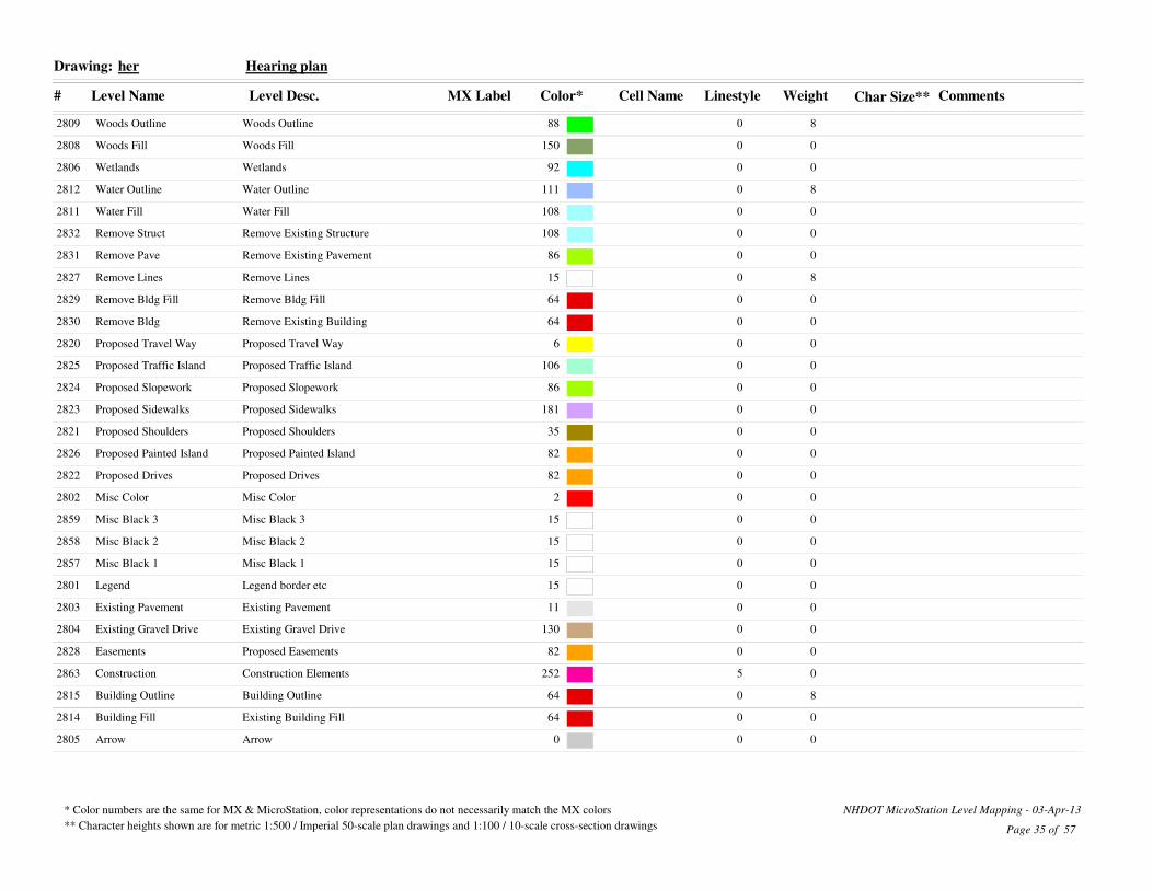
her Hearing planDrawing:
Weight Char Size**
82809 Woods Outline Woods Outline 88 0
02808 Woods Fill Woods Fill 150 0
02806 Wetlands Wetlands 92 0
82812 Water Outline Water Outline 111 0
02811 Water Fill Water Fill 108 0
02832 Remove Struct Remove Existing Structure 108 0
02831 Remove Pave Remove Existing Pavement 86 0
82827 Remove Lines Remove Lines 15 0
02829 Remove Bldg Fill Remove Bldg Fill 64 0
02830 Remove Bldg Remove Existing Building 64 0
02820 Proposed Travel Way Proposed Travel Way 6 0
02825 Proposed Traffic Island Proposed Traffic Island 106 0
02824 Proposed Slopework Proposed Slopework 86 0
02823 Proposed Sidewalks Proposed Sidewalks 181 0
02821 Proposed Shoulders Proposed Shoulders 35 0
02826 Proposed Painted Island Proposed Painted Island 82 0
02822 Proposed Drives Proposed Drives 82 0
02802 Misc Color Misc Color 2 0
02859 Misc Black 3 Misc Black 3 15 0
02858 Misc Black 2 Misc Black 2 15 0
02857 Misc Black 1 Misc Black 1 15 0
02801 Legend Legend border etc 15 0
02803 Existing Pavement Existing Pavement 11 0
02804 Existing Gravel Drive Existing Gravel Drive 130 0
02828 Easements Proposed Easements 82 0
02863 Construction Construction Elements 252 5
82815 Building Outline Building Outline 64 0
02814 Building Fill Existing Building Fill 64 0
02805 Arrow Arrow 0 0
Page 35 of 57
* Color numbers are the same for MX & MicroStation, color representations do not necessarily match the MX colors
** Character heights shown are for metric 1:500 / Imperial 50-scale plan drawings and 1:100 / 10-scale cross-section drawings
NHDOT MicroStation Level Mapping - 03-Apr-13

# Level Name Level Desc. MX Label Color* Cell Name Linestyle Comments
lnd LandscapingDrawing:
Weight Char Size**
14192 Shrubs Sweeet Fern 67 0
74172 Planting Bed Planting Bed 2 0
14178 Perennials Ground Cover Varities 6 0
14138 Deciduous Thundercloud Plum 40 0
04163 Construction Construction Elements 252 5
14118 Conifers Douglas Fir 40 0
Page 36 of 57
* Color numbers are the same for MX & MicroStation, color representations do not necessarily match the MX colors
** Character heights shown are for metric 1:500 / Imperial 50-scale plan drawings and 1:100 / 10-scale cross-section drawings
NHDOT MicroStation Level Mapping - 03-Apr-13

# Level Name Level Desc. MX Label Color* Cell Name Linestyle Comments
loc Project Location MapDrawing:
Weight Char Size**
01332 Text-Water River/Lake Names 15 0
21331 Text-Towns Town Names 0 0
01330 Text-Streets Street Names 0 0
01319 Streams Streams 108 0
01340 Signs Sign Shields 0 0
11347 Sign US Rte Wide US Route Sign Wide 4 0
11346 Sign US Rte US Route Sign 4 0
11345 Sign State Rte State Route Sign 4 0
11344 Sign Interstate Wide Interstate Route Wide 4 0
11343 Sign Interstate Interstate Route Sign 4 0
21324 Roads-US Roads-US 216 0
31323 Roads-Turnpike Roads-Turnpike 51 0
21325 Roads-State Roads-State 3 0
01327 Roads-Private Roads-Private 7 0
21326 Roads-Local Roads-Local 63 0
31322 Roads-Interstate Roads-Interstate 2 0
11317 RiversLakes Rivers and Lakes 5 0
01314 Rail-Inactive Railroads-Inactive 134 Railroad
01313 Rail-Active Railroads-Active 150 Railroad
01310 Parks State Parks 40 5
01350 North Arrow 0 0
11309 Forests National/State Forests 40 1
01318 Fills-Water Fills for Rivers and Lakes 11 0
01306 Contours Contours 161 0
01363 Construction Construction Elements 252 5
11303 Boundary-Town Boundary-Town 2 TownLine
31301 Boundary-State Boundary-State 2 7
21302 Boundary-County Boundary-County 2 County
31341 Border FS Location Map Outline 3 0
Page 37 of 57
* Color numbers are the same for MX & MicroStation, color representations do not necessarily match the MX colors
** Character heights shown are for metric 1:500 / Imperial 50-scale plan drawings and 1:100 / 10-scale cross-section drawings
NHDOT MicroStation Level Mapping - 03-Apr-13

# Level Name Level Desc. MX Label Color* Cell Name Linestyle Comments
pcn Proposed ContoursDrawing:
Weight Char Size**
24350 Intermediate Intermediate 111 3
24348 Index Label Index Label 111 0
34349 Index Index 111 0
04363 Construction Construction Elements 252 5
Page 38 of 57
* Color numbers are the same for MX & MicroStation, color representations do not necessarily match the MX colors
** Character heights shown are for metric 1:500 / Imperial 50-scale plan drawings and 1:100 / 10-scale cross-section drawings
NHDOT MicroStation Level Mapping - 03-Apr-13

# Level Name Level Desc. MX Label Color* Cell Name Linestyle Comments
pdr Prop. DrainageDrawing:
Weight Char Size**
3521 Underdrain Underdrain 13 UnderDrain-Prop
3545 Stream Stream 94 Ditch
1519 Stone Lining Stone Lining Pattern 4 0
3530 Sluiceway Sluiceway 13 0
3528 RCP end section Proposed RCP End Section 4 0
3560 Pipe Flow Arrow Pipe Flow Arrow 4 Arrow
3527 Metal end section Proposed Metal End Section 4 0
3537 Manhole Drainage Manhole 4 0
3510 High point Drainage high point 4 0
3526 Header Header 4 0
3515 Flushing Basin Flushing Basin 4 0
3549 Erosion Control note Erosion Control note 4 0
3536 Drop inlet Drop inlet 4 0
3520 Drain pipe Proposed Drainage 13 PipeP48
3548 Drain note Drainage notes 4 0
3532 Ditch line Ditch line 4 Ditch
0563 Construction Construction Elements 252 5
3534 Catch Basin Catch Basin 4 0
Page 39 of 57
* Color numbers are the same for MX & MicroStation, color representations do not necessarily match the MX colors
** Character heights shown are for metric 1:500 / Imperial 50-scale plan drawings and 1:100 / 10-scale cross-section drawings
NHDOT MicroStation Level Mapping - 03-Apr-13

# Level Name Level Desc. MX Label Color* Cell Name Linestyle Comments
pgr Prop. guard-railDrawing:
Weight Char Size**
3819 Ped Rail Pedestrian rail 15 PedRail
3818 Jersey Barrier Jersey barrier 15 JerseyBarrier
3804 Guardrail Notes Guardrail Note 15 0
3815 Guardrail Guardrail 15 BmGrLt
0863 Construction Construction 252 5
3813 Bridge rail Bridge approach rail 15 0
3840 Boulder Boulder 15 0
3820 Bike Rail Bike Rail 15 0
Page 40 of 57
* Color numbers are the same for MX & MicroStation, color representations do not necessarily match the MX colors
** Character heights shown are for metric 1:500 / Imperial 50-scale plan drawings and 1:100 / 10-scale cross-section drawings
NHDOT MicroStation Level Mapping - 03-Apr-13

# Level Name Level Desc. MX Label Color* Cell Name Linestyle Comments
ply Prop. layoutDrawing:
Weight Char Size**
3917 Trail Trail 7 0
3945 Stream Stream 94 Ditch
3950 Stone Wall Stone Wall 96 StoneWall-Prop
3932 Sound Wall Posts Sound Wall Posts 40 0
6931 Sound Wall Sound Wall 40 0
3959 Slope Label Slope Line 53 0
3914 Sidewalk Sidewalk 9 0
3947 Shoreline Rt Shoreline Rt 94 StreamRt
3946 Shoreline Lt Shoreline Lt 94 StreamLt
3934 ROW Slope ROW Slope 181 Fill
3929 Ret wall rt Ret wall rt 15 RetWallRt
3928 Ret wall lt Ret wall lt 15 RetWallLt
3922 Railroad Railroad 170 Railroad
3915 Radius Tick Radius Tick 81 0
6942 Pavement Removal Pavement Removal 15 0
3940 Painted Island Painted Island 212 0
3927 Other fence Other fence short 15 Fence-Nobarb(short)
3941 Gate Gate 15 0
3937 Fill slope Fill slope 53 Fill
3911 Edge of trav Edge of Traveled Way 15 0
3910 Edge of pave Edge of Pavement 6 0
3909 Edge of Lane Edge of Lane 6 0
3939 Earthworks General Earthworks General 53 0
3916 Driveway Driveway 81 0
3936 Cut Slope rt Cut Slope Right 53 CutRt
3935 Cut Slope lt Cut Slope Left 53 CutLt
3920 Curbed Island Curbed Island 154 0
3913 Curb Top Curb Top Right 15 PCurbRt
3912 Curb Bottom Curb Bottom 15 0
3933 Construction Slope Construction Slope 82 Fill
0963 Construction Construction Elements 252 5
Page 41 of 57
* Color numbers are the same for MX & MicroStation, color representations do not necessarily match the MX colors
** Character heights shown are for metric 1:500 / Imperial 50-scale plan drawings and 1:100 / 10-scale cross-section drawings
NHDOT MicroStation Level Mapping - 03-Apr-13

# Level Name Level Desc. MX Label Color* Cell Name Linestyle Comments
ply Prop. layoutDrawing:
Weight Char Size**
3938 Clearing Line Clearing Line 3 0
3958 Clearing Label Clearing Line Label 3 0
6943 Building Removal Building Removal 15 0
0944 Bridge Removal Bridge Removal 0 0
3926 Barbed wire fence Barbed Wire Fence short 15 Fence-Barbed(short)
Page 42 of 57
* Color numbers are the same for MX & MicroStation, color representations do not necessarily match the MX colors
** Character heights shown are for metric 1:500 / Imperial 50-scale plan drawings and 1:100 / 10-scale cross-section drawings
NHDOT MicroStation Level Mapping - 03-Apr-13

# Level Name Level Desc. MX Label Color* Cell Name Linestyle Comments
pnt Prop. notesDrawing:
Weight Char Size**
31015 Pavement Removal Notes Pavement Removal Notes 183 0
31056 Misc note Misc Notes 2 0
41005 Matchline Quantity Matchline 252 QML
31055 Fence note Fence Notes 15 0
31053 Demo note Const Demolition Notes Constr 2 0
31052 Demo note Demolition Notes ROW 2 0
01063 Construction Construction Elements 252 5
31030 Const Plan Limits Const Plan Limits 183 0
31031 Const notes Construction Notes 183 Arrow
31038 Clearing Areas Clearing Areas 3 0
31050 Bridge notes Bridge Notes 2 0
Page 43 of 57
* Color numbers are the same for MX & MicroStation, color representations do not necessarily match the MX colors
** Character heights shown are for metric 1:500 / Imperial 50-scale plan drawings and 1:100 / 10-scale cross-section drawings
NHDOT MicroStation Level Mapping - 03-Apr-13

# Level Name Level Desc. MX Label Color* Cell Name Linestyle Comments
pro Profiles (Roll Plan)Drawing:
Weight Char Size**
01261 Unknown Labels Unknown Labels 7 0
01260 Unidentified Elements Unidentified Elements 7 0
31253 Superelevation Zero Plane Left 4 0
31203 Subgrade Subgrade Text 4 0
31224 Stations Stations 4 0
21239 Rock line Rock line 173 Ledge
31244 Proposed Elevations Proposed Elevations 82 0
31238 Project Title Road Name and Number 4 0
31249 Profiles:Scales Profiles:Scales 4 0
31204 Profile Notes Profile text 4 ArBegSld
31240 Misc Text Misc Text 15 0
11246 Minor grid Minor grid 12 0
01215 Metric Stamp Metric Stamp 0 0
21245 Major grid Major grid 2 0
31207 Low Point Low Point 15 0
11210 High Water High water 5 0
31247 Grid text Grid Text 50 0
31222 Grade Text Grade Text 15 0
21206 Geometry Data Geometry data lines 79 0
01262 Extra Labels Extra Labels 7 0
21201 Existing Ground Existing Ground 3 0
11243 Existing Elevations Existing Elevations 2 0
31241 Equations Equations 15 0
41202 Design Design 4 0
31220 Datum Datum Text 15 0
31223 Curve data Curve data 15 0
31221 Ctrl Points PI Symbol 82 0
01263 Construction Construction Elements 252 5
11236 Border:CS:Wet Cut Sheet Text - Wetlands Impacts 2 0
11235 Border:CS:ROW Cut Sheet Text - ROW Plans 2 0
11234 Border:CS:Misc:Bur Cut Sheet Text 2 0
Page 44 of 57
* Color numbers are the same for MX & MicroStation, color representations do not necessarily match the MX colors
** Character heights shown are for metric 1:500 / Imperial 50-scale plan drawings and 1:100 / 10-scale cross-section drawings
NHDOT MicroStation Level Mapping - 03-Apr-13

# Level Name Level Desc. MX Label Color* Cell Name Linestyle Comments
pro Profiles (Roll Plan)Drawing:
Weight Char Size**
11230 Border:CS:Hwy Cut Sheet Label - Bureau of Highway De 4 0
11233 Border:CS:Const:Text Cut Sheet Text 2 0
11229 Border:CS:BoTraffic Cut Sheet Label - Bureau of Traffic 4 0
11228 Border:CS:BoROW Cut Sheet Label - Bureau of ROW 4 0
11227 Border:CS:BoEnv Cut Sheet Label - Bureau of Environment 4 0
11226 Border:CS:BoBridge Cut Sheet Label - Bureau of Bridge 4 0
01225 Border Cut Sheet Border 0 0
Page 45 of 57
* Color numbers are the same for MX & MicroStation, color representations do not necessarily match the MX colors
** Character heights shown are for metric 1:500 / Imperial 50-scale plan drawings and 1:100 / 10-scale cross-section drawings
NHDOT MicroStation Level Mapping - 03-Apr-13

# Level Name Level Desc. MX Label Color* Cell Name Linestyle Comments
prw Proposed Right-of-WayDrawing:
Weight Char Size**
32636 Temp Easement Labels Temp Easement Labels 81 0
32621 Takes Outline Takes Outline 81 0
12622 Takes Hatch Take Hatching 81 0
32619 T Outline Temp Ease Outline 81 0
32617 T Erosion Erosion Easement 11 0
32615 T Drive Drive Easement 11 0
32616 T Detour Detour Easement 11 0
32611 RRROW Railroad ROW Line 94 RRROW
32603 ROW Summary ROW Cut Sheet Summary 3 0
32641 Row Notes ROW Notes-Misc. 94 0
32640 Row limits Row limits 94 0
32642 Row Drive Line Drive Line-ROW 94 5
32608 ROW ROW Line 94 ROW
32629 P Water Water Easement 81 0
32630 P Utility Utility Easement 81 0
32625 P Slope Slope Easement 81 0
32628 P Sewer Sewer Easement 81 0
32627 P Ret Wall Retaining Wall Easement 81 0
32632 P Outline Perm Ease OutLine 81 0
32626 P Grail Guard Rail Easement 81 0
32631 P Channel Channel Easement 81 0
32610 LAROW LAROW Line 2 ROW
32653 Iron pin Iron Pin 15 0
12654 Flags Station and Offset Flagging 15 0
32635 Easement Labels Easement Labels 81 0
32614 Drive limit Drive Easement Limit 81 1
32624 Drainage Easement Fill Perm Drainage Easement Fill 81 0
02663 Construction Construction Elements 252 5
32618 Const Easement Fill Temp Const Easement Fill 11 0
32609 CAROW CAROW Line 3 ROW
32650 Bound Text Bound Text 15 0
Page 46 of 57
* Color numbers are the same for MX & MicroStation, color representations do not necessarily match the MX colors
** Character heights shown are for metric 1:500 / Imperial 50-scale plan drawings and 1:100 / 10-scale cross-section drawings
NHDOT MicroStation Level Mapping - 03-Apr-13

# Level Name Level Desc. MX Label Color* Cell Name Linestyle Comments
prw Proposed Right-of-WayDrawing:
Weight Char Size**
32651 Bound Flagging Bound Text 15 0
32652 Bound NH Bound 15 0
Page 47 of 57
* Color numbers are the same for MX & MicroStation, color representations do not necessarily match the MX colors
** Character heights shown are for metric 1:500 / Imperial 50-scale plan drawings and 1:100 / 10-scale cross-section drawings
NHDOT MicroStation Level Mapping - 03-Apr-13

# Level Name Level Desc. MX Label Color* Cell Name Linestyle Comments
psg Prop. signalizationDrawing:
Weight Char Size**
01416 Traffic sig Traffic Signal 212 0
31410 Traffic note Traffic Notes 212 0
31425 SWZ SWZ 122 0
01434 Strobe Strobe 212 0
01433 Signal head Signal head 212 0
31409 Signal conduit Signal conduit 9 ConduitS-Prop
31515 Sign single Single post sign 212 0
31540 Sign Removal Sign Removal Notes 212 0
31514 Sign double Double post sign 212 0
31423 Sig notes Signal Reference Number 212 0
11521 Route Sign Route Sign 15 0
11520 Road Sign Road Sign 15 0
31517 Reloc Sign Text Relocated Sign Text 212 Arrow
31505 Railroad Sign Railroad Sign 170 0
01408 Pullbox Pullbox 212 0
01431 Preemption Preemption OPTICOM 212 0
01430 Ped signal Pedestrian signal 212 0
01432 Ped sig pole Pedestrian signal pole 212 0
31511 Overhead Text Overhead sign structure text 212 0
31510 Overhead Overhead sign structure 212 0
01550 New signs New signs 212 0
31516 New Sign Text New Sign Text 212 Arrow
01413 Meter Pedestal Meter Pedestal 212 0
31415 Mast pole Mast pole 212 0
31407 Magnetic det Magnetic Detector sleeve 212 MagDet
31419 Loop Detector Loop Detector 212 0
31405 Lane markings Lane markings 212 0
01402 Junction box Junction box 212 0
31449 ITS Splice Vault ITS Splice Vault 6 0
31448 ITS Sign Vari Speed Limit ITS Sign Vari Speed Limit 9 0
31447 ITS Sign FO Delineator ITS Sign FO Delineator 9 0
Page 48 of 57
* Color numbers are the same for MX & MicroStation, color representations do not necessarily match the MX colors
** Character heights shown are for metric 1:500 / Imperial 50-scale plan drawings and 1:100 / 10-scale cross-section drawings
NHDOT MicroStation Level Mapping - 03-Apr-13

# Level Name Level Desc. MX Label Color* Cell Name Linestyle Comments
psg Prop. signalizationDrawing:
Weight Char Size**
31446 ITS Road n Weather Info Sys ITS Road n Weather Info Sys 6 0
31445 ITS notes ITS notes 6 0
31444 ITS Dynamic Mess Sign ITS Dynamic Mess Sign 6 0
31443 ITS Controller Cabint ITS Controller Cabint 6 0
31442 ITS Camera Pole ITS Camera Pole 6 0
31441 ITS ITS 6 ITS-Prop
01404 Handhole Handhole 212 0
21440 Fiber Optics Fiber Optics 6 FiberOptic-Prop
01403 Ctrlr cab Controller Cabinet 212 0
01463 Construction Construction Elements 252 5
01563 Construction Construction Elements 252 5
01530 Const signs Const signs G20 212 0
Page 49 of 57
* Color numbers are the same for MX & MicroStation, color representations do not necessarily match the MX colors
** Character heights shown are for metric 1:500 / Imperial 50-scale plan drawings and 1:100 / 10-scale cross-section drawings
NHDOT MicroStation Level Mapping - 03-Apr-13

# Level Name Level Desc. MX Label Color* Cell Name Linestyle Comments
put Prop. utilitiesDrawing:
Weight Char Size**
32256 Water und Underground Water 4 Water-Prop
32247 Water shutoff Water Shutoff 4 0
32246 Water gate Water Gate 4 0
32242 W manhole Water Manhole 4 0
32258 Vent Pipe Vent Pipe 3 0
32261 Utility pole note Prop Utility pole note 2 0
32221 Transmission line tower Transmission line tower 2 0
32254 Telephone und Underground Telephone 81 Tele-Prop
32241 Tele manhole Telephone Manhole 81 0
32220 Tel pole Telephone Pole 81 0
32219 Span Wire Pole Span Wire Pole 2 0
32253 Sewer und Underground Sewer 3 Sewer-Prop
32240 S manhole Sewer Manhole 3 0
32228 Railroad Switch Railroad Switchstand 170 0
32227 Railroad Signal Railroad Signal 170 0
32216 Pullbox Pullbox 212 0
32218 Power pole Power Pole 2 0
32209 Pole Pole 2 0
32257 Overhead Utility Overhead Utility 2 Electric-OH
32215 Mast pole Mast Arm Pole 212 0
32230 Lighting notes Lighting Notes 105 0
32213 Light power Power Pole with Light 2 0
32214 Light pole Light Pole 2 0
32212 Light joint Joint Pole with Light 2 0
32249 Light Conduit und Underground Light Conduit 2 Light-Prop
32211 Joint power Joint Pole 2 0
32204 ITS Intelligent Transportation Systems 6 ITS-Prop
32217 Handhole Handhole 212 0
32210 Guy pole Guy or Stub Pole 2 0
32252 Gas und Underground Gas 6 Gas-Prop
32245 Gas shutoff Gas shutoff 6 0
Page 50 of 57
* Color numbers are the same for MX & MicroStation, color representations do not necessarily match the MX colors
** Character heights shown are for metric 1:500 / Imperial 50-scale plan drawings and 1:100 / 10-scale cross-section drawings
NHDOT MicroStation Level Mapping - 03-Apr-13

# Level Name Level Desc. MX Label Color* Cell Name Linestyle Comments
put Prop. utilitiesDrawing:
Weight Char Size**
32239 G manhole Gas manhole 6 0
32244 Fire hydrant Fire Hydrant 4 0
32251 Fire Alarm und Underground Fire Alarm 81 Fire-Prop
32206 Fiber Optics Fiber Optics 6 FiberOptic-Prop
32250 Electric und Underground Electric 2 Electric-Prop
32238 E manhole Electric Manhole 2 0
02263 Construction Construction Elements 252 5
32255 Cable TV und Underground Cable TV 81 CATV
Page 51 of 57
* Color numbers are the same for MX & MicroStation, color representations do not necessarily match the MX colors
** Character heights shown are for metric 1:500 / Imperial 50-scale plan drawings and 1:100 / 10-scale cross-section drawings
NHDOT MicroStation Level Mapping - 03-Apr-13
# Level Name Level Desc. MX Label Color* Cell Name Linestyle Comments
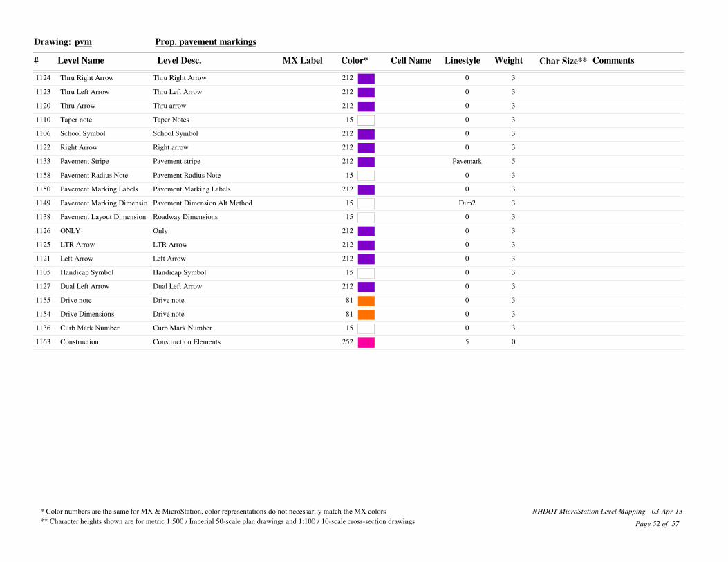
pvm Prop. pavement markingsDrawing:
Weight Char Size**
31124 Thru Right Arrow Thru Right Arrow 212 0
31123 Thru Left Arrow Thru Left Arrow 212 0
31120 Thru Arrow Thru arrow 212 0
31110 Taper note Taper Notes 15 0
31106 School Symbol School Symbol 212 0
31122 Right Arrow Right arrow 212 0
51133 Pavement Stripe Pavement stripe 212 Pavemark
31158 Pavement Radius Note Pavement Radius Note 15 0
31150 Pavement Marking Labels Pavement Marking Labels 212 0
31149 Pavement Marking Dimensio Pavement Dimension Alt Method 15 Dim2
31138 Pavement Layout Dimension Roadway Dimensions 15 0
31126 ONLY Only 212 0
31125 LTR Arrow LTR Arrow 212 0
31121 Left Arrow Left Arrow 212 0
31105 Handicap Symbol Handicap Symbol 15 0
31127 Dual Left Arrow Dual Left Arrow 212 0
31155 Drive note Drive note 81 0
31154 Drive Dimensions Drive note 81 0
31136 Curb Mark Number Curb Mark Number 15 0
01163 Construction Construction Elements 252 5
Page 52 of 57
* Color numbers are the same for MX & MicroStation, color representations do not necessarily match the MX colors
** Character heights shown are for metric 1:500 / Imperial 50-scale plan drawings and 1:100 / 10-scale cross-section drawings
NHDOT MicroStation Level Mapping - 03-Apr-13

# Level Name Level Desc. MX Label Color* Cell Name Linestyle Comments
pwt Prop. wetDrawing:
Weight Char Size**
32326 WetSum Wetland Impact Summary Chart 4 0
02325 Wetland Legend Wetland Legend 110 0
32324 WetImpLbl Wetland Impact Labels 110 0
32305 WetClsCode Wetland Classification Codes 4 0
32323 Wet Imp Permanent Non Wet Impact 110 0
32345 Stream Stream 94 Ditch
32347 ShoreRt Shoreline Right 94 StreamRt
32346 ShoreLt Shoreline Left 94 StreamLt
12310 Shore Impact Wetlands Juris Shore Impact Wetlands Jurisdiction 12 0
12311 Shore Impact REF to 50 Shore Impact REF to 50 6 0
32314 Shore Impact Label Shore Impact Label 110 0
12312 Shore Impact 50 to 150 Shore Impact 50 to 150 2 0
12313 Shore Impact 150 to 250 Shore Impact 150 to 250 3 0
42320 PropWetlnd Proposed Wetland 4 Wetland
42321 Mitigation Hatch Mitigation Area 4 0
32340 Erosion Control Erosion Control Items 3 0
Page 53 of 57
* Color numbers are the same for MX & MicroStation, color representations do not necessarily match the MX colors
** Character heights shown are for metric 1:500 / Imperial 50-scale plan drawings and 1:100 / 10-scale cross-section drawings
NHDOT MicroStation Level Mapping - 03-Apr-13

# Level Name Level Desc. MX Label Color* Cell Name Linestyle Comments
txt Existing textDrawing:
Weight Char Size**
11632 Wetland txt Wetland Delineated 4 Arrow
11631 Wet Area txt Wet Area or Stream 5 0
11610 Tree txt Trees 3 Arrow
11619 To Town note To Town or City leader line 6 Arrow2
11620 Structure txt Structures leader line 96 Arrow
11615 Sign txt Signs 9 Arrow
21611 Road Names Road Names 6 0
21618 River Names River Names 6 0
21604 Prelim Stamp Prelim Plan Stamp 2 0
01603 PP Stamp Plan Prep Stamp 2 0
11616 Pole txt Poles 161 Arrow
11630 Pipe txt Pipes 4 Arrow
01608 Photo Photo Location 2 0
11622 Orn Feature txt Ornamental Feature 122 Arrow
11640 Misc txt Miscellaneous leader line 214 Arrow
01602 Metric Stamp Metric Stamp 48 0
11621 Guardrail txt Guardrail 96 Arrow
11605 General txt General leader line 3 Arrow
11613 Flow arrow River Flow Arrow 5 0
21641 Field Check txt Field Check 19 Arrow
11627 Fence txt Fence 96 Arrow
11617 Driveway txt Driveway leader line 81 Arrow
01663 Construction Construction Elements 252 5
11625 Building txt Building leader line 2 Arrow
Page 54 of 57
* Color numbers are the same for MX & MicroStation, color representations do not necessarily match the MX colors
** Character heights shown are for metric 1:500 / Imperial 50-scale plan drawings and 1:100 / 10-scale cross-section drawings
NHDOT MicroStation Level Mapping - 03-Apr-13

# Level Name Level Desc. MX Label Color* Cell Name Linestyle Comments
xsu Cross-section DetailsDrawing:
Weight Char Size**
22416 Xsect Misc Exist Muck Muck 25 0
22406 Xsect Misc Exist Ledge Ledge 173 Ledge
02454 XS Title Text Xsect Title Box Text 3 0
02453 XS Title M Xsect Title Box Metric 3 0
02452 XS Title I Xsect Title Box Imperial 81 0
02451 XS Title Box XS Title Box 2 0
12450 XS Inner Bdr Xsect Inner Border 2 0
22461 Utility pole note Utility pole note 2 0
22413 Unknown Labels Unknown Labels 7 0
02442 Title Block Title Block 2 0
42409 Temporary Temporary 52 0
42441 Superelevation Superelevation 2 0
22403 Subgrade Subgrade Sidewalk 4 0
02479 Structural Fill Structural Fill Area 31 0
02473 Stonefill Stonefill Area 32 0
42414 Station Text Station Text 38 0
42427 Slope Tick Slope Tick 2 0
42471 Skew Drive Skew Drive Ahead Left 6 0
42428 Sill Sill 2 0
22469 Shrubs Shrub Right 3 0
42422 Sand Sand Area 81 0
42467 ROW ROW Proposed Right 94 ROW
02478 Rock Structure Excavation Rock Structure Excavation Area 82 0
02472 Rock Excavation Rock Excavation Area 78 0
42405 QML Notes Quantity Matchline Text 252 Arrow
42404 QML Quantity Matchline 252 QML
42432 Prop Tree Proposed Tree 3 0
42434 Prop Drainage Proposed Drainage 13 XPipP15
42415 Prop Detail Proposed Detail 15 0
22448 Project Title Project Title 7 0
42408 Other Other 52 0
Page 55 of 57
* Color numbers are the same for MX & MicroStation, color representations do not necessarily match the MX colors
** Character heights shown are for metric 1:500 / Imperial 50-scale plan drawings and 1:100 / 10-scale cross-section drawings
NHDOT MicroStation Level Mapping - 03-Apr-13

# Level Name Level Desc. MX Label Color* Cell Name Linestyle Comments
xsu Cross-section DetailsDrawing:
Weight Char Size**
42438 Notes Notes 2 0
32465 NJ Barrier NJ Barrier 9 0
02462 MX Controls MX Controls 72 0
02480 Muck Excavation Muck Excavation Area 25 0
42420 Misc Section M Misc Section M 65 0
42419 Misc Section L Misc Section L 197 0
42418 Misc Section K Misc Section K 34 0
42417 Misc Section J Misc Section J 110 0
12446 Minor Grid Minor Grid 12 0
22445 Major Grid Major Grid 2 0
22447 Grid Text Grid Text 50 0
42421 Gravel Gravel Area 183 0
02475 Granular Backfill Granular Backfill Area 120 0
02444 General General 84 3
42425 Fill Fill Area 34 0
22411 Feature Labels Feature Labels 95 0
22412 Extra Labels Extra Labels 7 0
22401 Existing Ground Existing Ground 3 0
22430 Exist Tree Existing Tree 3 0
22433 Ex Drainage Existing Drainage 4 XPipE48
22407 Environment Environment 110 0
02476 Drive Fill Drive Fill Area 19 0
02477 Drive Excavation Drive Excavation Area 210 0
42440 Dimensions Xsect Dimensions ft 5-scale 2 0
02443 Details Detail Features 84 0
22410 Detail Detail 81 0
42402 Design Design 4 0
42426 Cut Cut Area 2 0
42435 Curb Bituminous Curb A 5in Right 15 0
42423 CRGravel Crushed Gravel Area 9 0
42425 Cr Stone Fine Cr Stone Fine 109 0
Page 56 of 57
* Color numbers are the same for MX & MicroStation, color representations do not necessarily match the MX colors
** Character heights shown are for metric 1:500 / Imperial 50-scale plan drawings and 1:100 / 10-scale cross-section drawings
NHDOT MicroStation Level Mapping - 03-Apr-13

# Level Name Level Desc. MX Label Color* Cell Name Linestyle Comments
xsu Cross-section DetailsDrawing:
Weight Char Size**
42424 Cr Stone Coarse Cr Stone Coarse 59 0
02463 Construction Construction Elements 252 5
02474 Common Structure Excavati Common Structure Excavation Area 197 0
32456 Border:XS Border:XS 2 0
Page 57 of 57
* Color numbers are the same for MX & MicroStation, color representations do not necessarily match the MX colors
** Character heights shown are for metric 1:500 / Imperial 50-scale plan drawings and 1:100 / 10-scale cross-section drawings
NHDOT MicroStation Level Mapping - 03-Apr-13