Embed Size (px)
Citation preview

May 5, 2010NewsCoast Survey responds to oil spillPresident Obama told the country on Sunday that we are facing “a massive and potentially unprecedented environmental disaster” from BP’s ongoing Deepwater Horizon oil spill.
Coast Survey is assisting in the response in order to ensure safe and ecologically protective transit of shipping vessels and others. The Lower Mississippi River ports export over 50 million metric tons of corn, soybeans and wheat each year, more than 55% of all U.S. grains inspected for shipment. Grain market participants and midwestern farmers, who need efficient port operations to export product, are following the situation closely, as are all segments of the economy that rely on timely import arrivals. Coast Survey’s work in ensuring efficient maritime transportation during this critical time is key to a healthy U.S. economy.
Marine Chart Division updating charts dailyTo support the continuation of safe and efficient maritime commerce, NOAA is producing nautical chart products that display the spill zone forecast based on current spill projections. The charts depict the 48 hour forecast for oil location, juxtaposed against the standard safety fairways that lead to the port approaches.
Mariners can access NOAA Electronic Navigational Charts (NOAA ENC®) US3GC04M and US3GC05M, and the NOAA Raster Navigational Chart (NOAA RNC®) and Print on Demand Chart 11360. The raster and electronic charts are available from Coast Survey’s chart downloader website. Print-On-Demand charts are available from NOAA’s Print-on-Demand agents.
Coast Survey is also coordinating with the United Kingdom Hydrographic Office, to provide the spill forecast data for UK charting systems used by foreign vessels coming into U.S. ports.
Nautical charts display spill projections
Cartographers Sean Legeer (left) and Leland Snyder have been working 7 days a week to update ENCs and RNCs.
Special Deepwater Horizon Edition
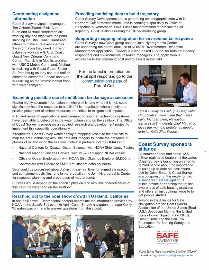
Coordinating navigation informationCoast Survey navigation managers Tim Osborn, Patrick Fink, Alan Bunn and Michael Henderson are working day and night with the ports, shipping industry, Coast Guard and others to make sure everyone has the information they need. Tim is in Lafayette working with U.S. Coast Guard New Orleans Command Center; Patrick is in Mobile, working with USCG Mobile Command; Michael is assisting with Coast Guard Sector St. Petersburg as they set up a unified command center for Florida; and Alan is assisting on the environmental front with water sampling.
Providing modeling data to build trajectoryCoast Survey Development Lab is generating oceanographic data with its Northern Gulf of Mexico model, and is sending output daily to Office of Response & Restoration. OR&R uses the information to forecast the oil trajectory. CSDL is also assisting the OR&R modeling group.
Supporting mapping integration for environmental responseCoast Survey’s nowCoast group and the Joint Hydrographic Center are supporting the operational use of NOAA’s Environmental Response Management Application. ERMA® is a web-based GIS tool for both emergency responders and environmental resource managers. The application is accessible to the command post and to assets in the field.
Examining possible use of multibeam for damage assessmentHaving highly accurate information on where oil is, and where it is not, could significantly help the response to a spill of this magnitude, where timely and precise placement of limited resources are critical to mitigate spill impacts.In limited research applications, multibeam echo sounder technology systems have been able to detect oil in the water column and on the seafloor. The Office of Coast Survey is proposing an applied research and development project to implement this capability operationally. If requested, Coast Survey would deploy a mapping vessel to the spill site to map the area, extracting acoustic data and imagery to locate the presence of plumes of oil and oil on the seafloor. Potential partners include OMAO and:• National Centers for Coastal Ocean Science, with NOAA Ship Nancy Foster;• National Marine Fisheries Service, with ME-70 equipped NOAA vessel;• Office of Ocean Exploration, with NOAA Ship Okeanos Explorer EM302; or• Contractors with EM302 or EM710 multibeam echo sounders.Data could be processed aboard ship in near-real time for immediate reaction and containment activities, and in more detail at the Joint Hydrographic Center for response planning and preparation of map products. Success would depend on the specific physical and acoustic characteristics of this oil in the water and on the seafloor.
Reaching out to the boat show crowd in Oakland, CaliforniaIn non-spill news... Recreational boaters appreciate the information provided by NOAA at the Strictly Sail event in April. Coast Survey navigaton manager Gerry Wheaton was on hand to answer questions from the crowd.
Coast Survey has set up a Deepwater Coordination Committee that meets daily. Pictured here, Navigation Services acting deputy chief Matt Kroll gives the morning update, as deputy director Katie Ries listens.
Coast Survey sponsors alliance As summer nears and some 12.5 million registered boaters hit the water, Coast Survey is launching an effort to remind people about the importance of using up-to-date nautical charts. Led by Dave Enabnit, Coast Survey is a co-sponsor of the newly formed Alliance for Safe Navigation, a public-private partnership that raises awareness of safe boating practices and offers an instructional website to get people started.Joining in the Alliance for Safe Navigation are the Boat Owners Association of the United States (Boat U.S.), Jeppesen Marine, the United States Power Squadrons (USPS), OceanGrafix and the Sea Tow Foundation for Boating Safety and Education.
Coast Survey News is published by NOAA Office of Coast Survey, [email protected], editor.
For the latest information on the oil spill response, go to the
communications page of Port of Call.