Embed Size (px)
Citation preview
April 2016
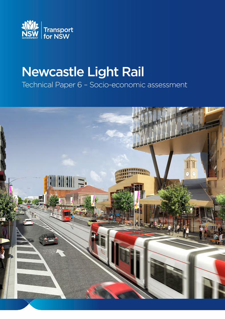
Newcastle Light RailTechnical Paper 6 – Socio-economic assessment
GHD | Report for Transport for NSW - Newcastle Light Rail, 22/17478
This report has been prepared by GHD for Transport for NSW and may only be used and relied on by Transport for NSW for the purpose agreed between GHD and the Transport for NSW as set out in section 1.3 of this report.
GHD otherwise disclaims responsibility to any person other than Transport for NSW arising in connection with this report. GHD also excludes implied warranties and conditions, to the extent legally permissible.
The services undertaken by GHD in connection with preparing this report were limited to those specifically detailed in the report and are subject to the scope limitations set out in the report.
The opinions, conclusions and any recommendations in this report are based on conditions encountered and information reviewed at the date of preparation of the report. GHD has no responsibility or obligation to update this report to account for events or changes occurring subsequent to the date that the report was prepared.
The opinions, conclusions and any recommendations in this report are based on assumptions made by GHD described in this report (refer to section 1.4 of this report). GHD disclaims liability arising from any of the assumptions being incorrect.
Whilst every care has been taken to prepare the maps for this report, GHD and LPI makes no representations or warranties about its accuracy, reliability, completeness or suitability for any particular purpose and cannot accept liability and responsibility of any kind (whether in contract, tort or otherwise) for any expenses, losses, damages and/or costs (including indirect or consequential damage) which are or may be incurred by any party as a result of the map being inaccurate, incomplete or unsuitable in any way and for any reason. © 2016.
GHD | Report for Transport for NSW - Newcastle Light Rail, 22/17478
Table of contents
Abbreviations ............................................................................................................................................. i
Executive summary .................................................................................................................................. ii
1. Introduction..................................................................................................................................... 1
1.1 Background to the proposal ................................................................................................. 1
1.2 The proposal ........................................................................................................................ 1
1.3 Purpose and scope of the assessment ................................................................................ 3
1.4 Study area ............................................................................................................................ 4
1.5 Structure of this report ......................................................................................................... 4
2. Socio-economic profile ................................................................................................................... 7
2.1 Overview .............................................................................................................................. 7
2.2 Demographic summary ........................................................................................................ 7
2.3 Social infrastructure ............................................................................................................. 7
2.4 Economy .............................................................................................................................. 8
2.5 Travel patterns ..................................................................................................................... 9
3. Policy and planning context ......................................................................................................... 11
3.1 State Government .............................................................................................................. 11
3.2 Newcastle City Council ...................................................................................................... 12
4. Consultation outcomes and community values............................................................................ 14
4.1 Consultation prior to REF preparation ............................................................................... 14
4.2 Issues raised ...................................................................................................................... 14
5. Socio-economic assessment and mitigation ................................................................................ 16
5.1 Overview ............................................................................................................................ 16
5.2 Socio-economic impacts .................................................................................................... 16
6. Mitigation measures ..................................................................................................................... 30
7. Conclusion.................................................................................................................................... 34
8. References ................................................................................................................................... 35
Table index
Table 5-1 Impact significance ratings ................................................................................................ 16
Table 5-2 Social infrastructure at key impact points on the proposal route ....................................... 23
Table 5-4 Summary of local socio-economic impacts........................................................................ 26
Table 6-1 Social impact mitigation measures .................................................................................... 31
Table A-1 Index of relative socio-economic disadvantage for suburbs .............................................. 40
GHD | Report for Transport for NSW - Newcastle Light Rail, 22/17478
Figure index
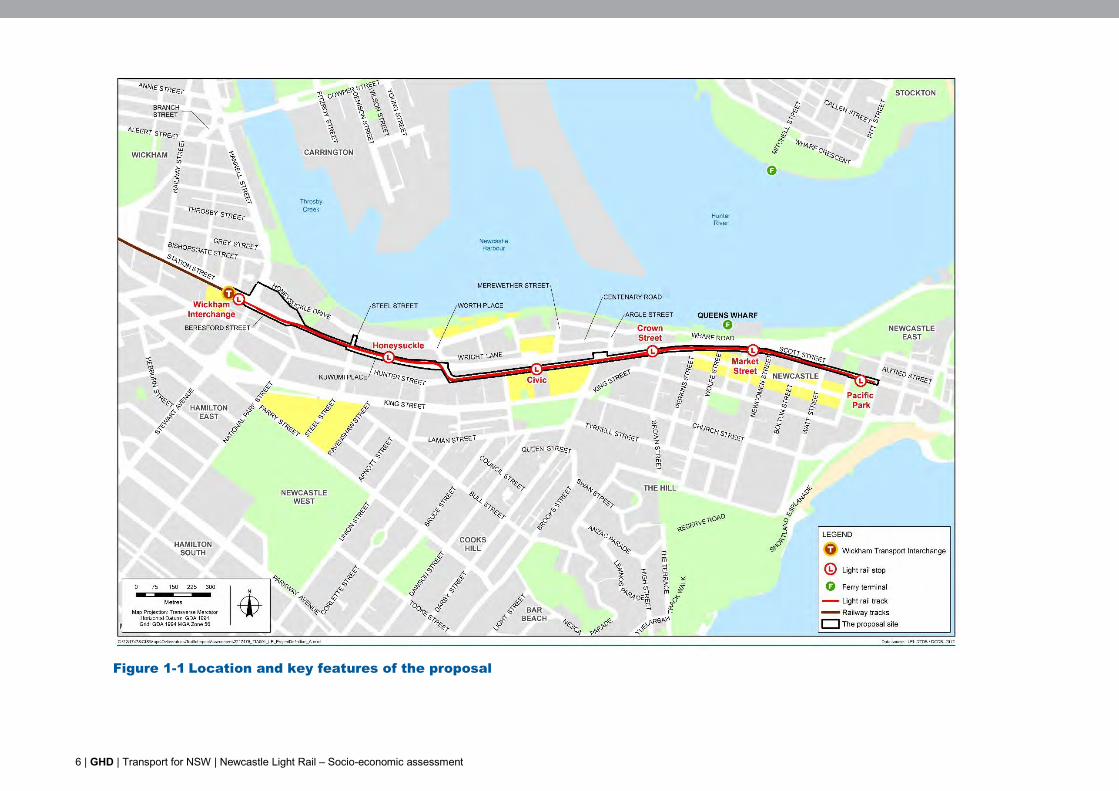
Figure 1-1 Location and key features of the proposal ........................................................................... 6
Figure 5-1 Kuwumi Place – new heavy rail pedestrian and cycle crossing of the former rail corridor ............................................................................................................................... 18
Figure A-1 Household composition in the local and regional area ...................................................... 38
Figure A-2 Incidents of non-domestic assault 2010 to 2011 ............................................................... 40
Figure A-3 Incidents of non-domestic assault 2012 to 2013 ............................................................... 41
Figure A-4 Incidents of non-domestic assault 2014 to 2015 ............................................................... 41
Figure A-5 Newcastle LGA employment and economic output by industry ........................................ 43
Figure A-6 Vacant Hunter Street frontage adorned with public mural ................................................. 44
Figure A-7 Purpose of travel to Newcastle city centre ........................................................................ 45
Figure A-8 Mode of work travel to Newcastle centre ........................................................................... 46
Appendices
Appendix A – Socio-economic profile
Appendix B – Demographic indicators
Appendix C – Social Infrastructure in or adjacent to the study area
GHD | Transport for NSW | Newcastle Light Rail – Socio-economic assessment | i
Abbreviations
Abbreviation Definition ABS Australian Bureau of Statistics BOSCAR Bureau of Crime Statistics and Research CBD central business district CEMP construction environmental management plan EP&A Act Environmental Planning and Assessment Act 1979 GHD GHD Pty Ltd LGA local government area NUTTP Newcastle Urban Transformation and Transport Program PB Parsons Brinckerhoff REF Review of Environmental Factors TfNSW Transport for NSW
ii | GHD | Transport for NSW | Newcastle Light Rail – Socio-economic assessment
Executive summary
This socio-economic assessment has been undertaken for Transport for NSW (TfNSW) for the proposed Newcastle Light Rail project (the proposal) and forms part of the Review of Environmental Factors (REF) for the proposal.
The proposal is a key infrastructure element in the Newcastle Urban Renewal Strategy (Department of Planning and Infrastructure, 2012) and the Newcastle Urban Transformation and Transport Program (NUTTP). The proposal would support urban redevelopment of public, residential and commercial lands by providing an efficient and accessible form of transport for Newcastle city centre. The truncation of the heavy rail at Wickham and development of the new transport interchange at Stewart Avenue is an important precursor. This has already resulted in improved connectivity in the city with six new pedestrian and cycle crossings across the redundant heavy rail corridor improving access to the foreshore.
This assessment has identified socio-economic benefits and impacts during construction and operation of the proposal and proposes mitigation measures to reduce and ameliorate identified impacts.
Construction impacts
The key construction impacts relate to access and amenity impacts, which have the potential to impact residents, businesses and other service providers along the route. These construction impacts may also affect other road users and pedestrians. Construction impacts identified include:
Congestion and uncertainty for city road users.
Reduced parking impacting accessibility and convenience for business operators, patrons and less mobile customers.
Changes to movement patterns for bus users and vehicles and temporary closure of recently opened heavy rail corridor crossings.
Visual, noise and vibration amenity impacts for nearby residents and businesses.
Alterations (variously potentially beneficial and adverse) to volumes of passing trade for businesses.
Opportunities for local employment and upskilling.
Operation impacts
Operation of the proposal would deliver the benefits of improved connectivity and permeability of the city and increased quality and diversity of transport services. This would contribute to an overall enhanced amenity for the city centre and facilitate successful urban renewal.
Operational impacts identified include:
Improved permeability and walkability of the city centre as a result of new signalised road crossings, potential for integration with other active travel infrastructure, and improved public transport access. This would lead to a more vibrant and desirable character for residents, workers, recreational visitors and tourists, and is also expected to deliver benefits to businesses along the route and more broadly in Newcastle city centre.
Improved connectivity for Newcastle East.
Minor negative impacts for businesses and less mobile customers due to loss or altered parking and loading zones along the route.

GHD | Transport for NSW | Newcastle Light Rail – Socio-economic assessment | iii
Public transport benefits with light rail generally considered a preferred mode of transport over buses, providing greater reliability and more comfortable travel.
Changes to local amenity as a result of changes in a type of noises in the area (i.e. new noise sources such as light rail approach bells and air conditioners).
Mitigation measures are proposed to avoid or reduce these and other potentially adverse impacts, and to enhance positive social outcomes from the project.
GHD | Transport for NSW | Newcastle Light Rail – Socio-economic assessment | 1
1. Introduction
1.1 Background to the proposal
The NSW Government is revitalising the Newcastle city centre. The revitalisation will reinforce the city’s role as a 21st century regional centre, unlock the potential of the city centre as a place that can meet the needs of the current and future community, and boost economic activity across the Hunter Region.
The Newcastle Urban Transformation and Transport Program (NUTTP) has been established to deliver the NSW Government’s $510 million commitment to revitalise the city. The program aims to bring people back to the city centre by strengthening connections between the city and the waterfront, creating employment opportunities, providing more public space and amenity, and delivering better transport. The NUTTP comprises:
1. Urban redevelopment/renewal projects being led by Urban Growth
2. The transport program being led by Transport for NSW (TfNSW)
The transport program seeks to revitalise Newcastle by improving pedestrian and vehicle connectivity within the city centre and by promoting public transport usage and accessibility. TfNSW is now proposing to progress development of the Newcastle Light Rail project. The construction and operation of the Newcastle Light Rail project is referred to as ‘the proposal’ in this document.
GHD Pty Ltd (GHD) was commissioned by TfNSW to undertake an assessment of the potential environmental impacts of the proposal and prepare a review of environmental factors (REF) in accordance with the provisions of Part 5 of the Environmental Planning and Assessment Act 1979 (the EP&A Act).
1.2 The proposal
1.2.1 Location
The proposal site (the area that would be generally affected by construction works) is located in the Newcastle city centre and extends in an east–west direction within the former rail corridor and road reserves. It is bounded to the west by the Wickham Transport Interchange near Stewart Avenue. From the Wickham Transport Interchange the proposal site extends east along Beresford Street and enters the former rail corridor near the existing Wickham Station buildings. The proposal site is located within the former rail corridor from this point until near Worth Place, where it enters the road corridor and travels along Hunter Street and Scott Street to the eastern boundary of Pacific Park.
The proposal site also includes the proposed location for the two electrical substations in the former rail corridor to the west of Argyle Street.
The location of the proposal is shown in Figure 1-1.
2 | GHD | Transport for NSW | Newcastle Light Rail – Socio-economic assessment
1.2.2 Overview of key features
The proposal involves the construction and operation of a light rail system in the Newcastle city centre, and associated changes to the road and bus network. This would include:
Light rail infrastructure
About 2.7 kilometres of light rail track, consisting of about 2.5 kilometres of dual track and 180 metres of single track.
Six light rail stops and associated infrastructure (such as platforms, shelters and lighting):
– Wickham Interchange
– Honeysuckle
– Civic
– Crown Street
– Market Street
– Pacific Park
A light rail stabling and maintenance facility at the location of the existing Wickham Station.
Terminus facilities near the Pacific Park stop.
Ancillary infrastructure, including two new substations, power supply, wiring and utilities.
Former rail corridor works
Remove the existing Wickham Station buildings, platforms and pedestrian bridge.
Remove the pedestrian bridge over the former rail corridor to the west of Market Street.
Transport network works
Bus network
Remove seven existing bus stops along Hunter and Scott streets and provide four new stops in Watt Street, Wharf Road (two stops) and Centenary Road.
Road network and intersection changes
Changes to the road configuration along the light rail corridor to accommodate the light rail infrastructure on Beresford, Hunter and Scott streets.
Changes to the following intersections along the light rail corridor:
– Stewart Avenue/Beresford Street
– Steel Street at the former rail corridor
– Hunter Street/Worth Place
– Pacific Street/Scott Street
New signalised road crossings to provide access to light rail stops:
– At Hunter Street near Crown Street
– At Scott Street near Market Street
New signalised road crossings of the former rail corridor at:
– Steel Street
– Worth Place
Changes to the road configuration outside the light rail corridor at the following locations:
GHD | Transport for NSW | Newcastle Light Rail – Socio-economic assessment | 3
– Honeysuckle Drive and Stewart Avenue/Hannell Street
– King Street from Union Street to Darby Street
– King Street intersection northbound on Darby Street
– Darby Street intersection southbound on Darby Street
Operation of the proposal
Mix of segregated, separated and mixed running.
Light rail services would commence at 5am and finish at 1am.
Between the core hours of 7am and 7pm, services would operate every 10 minutes on weekdays and every 15 minutes on weekends.
Less frequent services would be provided in the early morning, evening and night periods.
Five light rail vehicles would operate with capacity for a minimum of 100 passengers per vehicle.
1.3 Purpose and scope of the assessment
1.3.1 Purpose of the assessment
This socio-economic assessment has been prepared as an input to the REF. It considers the potential socio-economic benefits, impacts and risks of the proposal. It identifies mitigation measures to avoid or mitigate adverse impacts, and enhance opportunities for improved social outcomes.
This socio-economic assessment considers the potential impacts directly related to the construction and operation of the proposal, including the potential for impacts to businesses. It does not include a quantitative assessment of the broad direct or indirect economic impacts of the proposal, or the potential socio-economic impacts of the consequent and likely consecutive progression of urban renewal activities.
1.3.2 Methodology
The socio-economic assessment has mainly involved desktop analysis, drawing on the extensive data and information available as a result of the planning and consultation completed to date for the Newcastle Urban Renewal Strategy. The socio-economic assessment has involved the following tasks:
Site visit to review existing land uses and local conditions.
Development and analysis of a community profile from information sourced through a desktop review of various publicly available sources, including:
– Australian Bureau of Statistics (ABS) Census 2011 data
– NSW Bureau of Crime Statistics and Research (BOSCAR)
– Bureau of Transport Statistics data
– Information available from the Council of the City of Newcastle (Council)
Social research to identify and consider local issues and community values.
Review of other specialist reports prepared for the REF, including assessments of the potential impacts of the proposal on local parking and traffic, visual amenity and noise and planning reports.
4 | GHD | Transport for NSW | Newcastle Light Rail – Socio-economic assessment
Analysis of the outcomes of previous community consultation undertaken by UrbanGrowth NSW and TfNSW as part of the NUTTP (including the results of the ‘Design Newcastle’ and ‘Design Newcastle 2’ consultation).
Review of media discussion of social issues relevant to the proposal.
Identification of the potential socio-economic impacts and benefits that would result from the proposal.
1.4 Study area
The proposal is located within the City of Newcastle local government area (LGA), which is about 160 kilometres north of Sydney, within the Lower Hunter region. Newcastle is the largest regional city in NSW, and is the major centre for the Lower Hunter region. The city supports a range of regional services focused around transport, education and health.
The socio-economic assessment considers the potential direct impacts of the proposal on the socio-economic environment of the local area surrounding the proposal site, and the potential indirect impacts on the broader urban area/region. Most of the potential impacts would occur in the local area, relating to the users of land in the immediate vicinity of the proposal site. Additionally, users of road transport and visitors to the centre of Newcastle may also be impacted by the proposal.
The assessment focuses on the potential direct local impacts of the proposal, the focus of which is the Newcastle city centre. The Newcastle city centre includes the city’s central business district (CBD), local beaches, cultural precincts (including the Newcastle Art Gallery and Museum), residential areas, the Newcastle Harbour foreshore and several public parks which provide a place for many outdoor events and festivals. The Honeysuckle area also provides recreational activities such as walking and cycling paths.
The assessment of indirect regional impacts considers Greater Newcastle, which includes the Newcastle, Maitland and Lake Macquarie LGAs.
1.5 Structure of this report
This report consists of the following sections:
Section 1 – Introduction: provides an overview of the project and the scope of the socio-economic assessment
Section 2 – Socio-economic profile: describes the socio-economic character of the study area by use of demographic information, descriptions of existing social infrastructure the nature of the economy and travel patterns in Newcastle
Section 3 – Policy and planning context: describes relevant local and state government policies plans and strategies and key city centre developments
Section 4 – Consultation outcomes and community values: summarises key relevant outcomes of consultation undertaken in planning for light rail and Newcastle urban renewal
Section 5 – Socio-economic assessment and mitigation: discusses the likely socio-economic benefits, impacts and risks generated by the projects, concluding with a summary of socio-economic impacts and recommended mitigation measures
GHD | Transport for NSW | Newcastle Light Rail – Socio-economic assessment | 5
Section 5 – Mitigation measures: outlines the recommended socio-economic mitigation measures to avoid negative impacts and enhance positive social outcomes. This section includes only those measures recommended by this report, and are additional to those of other specialist reports
Section 7 – Conclusion: presents a summary of the key findings and recommendations of the impact assessment
6 | GHD | Transport for NSW | Newcastle Light Rail – Socio-economic assessment
Figure 1-1 Location and key features of the proposal
GHD | Transport for NSW | Newcastle Light Rail – Socio-economic assessment | 7
2. Socio-economic profile
2.1 Overview
This section provides a summary of key points from the community profile that are described further in Appendix A. The profile as a whole provides an overview of residents living in the Newcastle city centre. The profile builds a picture of the community that would potentially be affected by the proposal and provides demographic indicators that can be used to predict different impacts and responses to impacts. Data on the Newcastle city centre, Newcastle LGA and Greater Newcastle region is provided for comparison and to identify those in the wider area that may be directly and indirectly affected by the proposal.
Data reviewed to prepare the profile is provided in Appendix B.
2.2 Demographic summary
Key socio-economic features of the study area are summarised below:
The study area had a population of about 4,000 people in 2011.
Demographic:
– Newcastle city centre has a significantly different demographic compared with other areas of Newcastle and the region, with a much higher incidence of lone person households, couples without children, and group households.
– This demonstrates a younger overall population with many students and empty nesters also showing a preference to live in the city centre.
– The average age is 35 years with around 31 per cent of the population aged 50 years and over and low numbers of people requiring assistance.
Small households:
– Households are mainly lone households and couples without children and living in apartments and semi-detached dwellings.
– Almost 60 per cent of households are renting, suggesting a high turnover of residents.
2.3 Social infrastructure
Newcastle is an important location for both local and regional social infrastructure, providing a variety of services and facilities. Community facilities, service providers and community organisations within the vicinity of the proposal site are described in Appendix C.
Within the vicinity of the proposal site there are several local/regional offices of various State government departments, such as Aboriginal Affairs, the Office of Environment and Heritage, and the Department of Planning and Environment, located on Honeysuckle Drive (to the north of the heavy rail corridor). Hunter Street is the location of NSW Health and numerous employment, medical and allied health services and community organisations, with some also located in Scott Street. Federal government social services (Centrelink and Medicare) are located in King Street.
Public spaces around the Newcastle foreshore provide a location for a number of large events. The annual New Year’s Eve celebration is the largest of these, though other events, such as gatherings on Anzac Day, also use this area. These events require additional transport planning as the crowds exceed regular transport capacity.
8 | GHD | Transport for NSW | Newcastle Light Rail – Socio-economic assessment
2.4 Economy
The Newcastle LGA plays a central role in the Hunter Region as the ‘regional capital’, with a diverse economy. It also:
Is the centre for critical infrastructure, including the port.
Provides services to the region including health, higher education, financial services, professional services and government services.
Is the headquarters of a number of major organisations.
Has a high concentration of manufacturing/engineering businesses that are servicing national and international markets.
Has a significant knowledge industries sector.
2.4.1 Businesses along the proposal site
The key centres of employment and business in Newcastle are located in the city centre, with secondary centres at Lambton (in the vicinity of the John Hunter Hospital), Adamstown/Kotara (a key retail area), and in Callaghan (based around the Newcastle University main campus).
Within the Newcastle city centre, Hunter Street is the traditional retail main street, hosting a diversity of retail and commercial properties and social and government services, with the Civic precinct at its centre. Retail activity is centred on the Hunter Street Mall, which leads into public recreation areas near the beach. The area along Honeysuckle is a relatively new commercial precinct.
As of the end of 2014, about 280 non-residential properties were identified adjacent to the proposal site. About 77 per cent of these are commercial businesses, with 13 per cent not for profit or government social services, and about 10 per cent vacant commercial space.
‘Renew Newcastle’ is an initiative backed by supporters from the local, State and Federal Governments, and the local business community. It is spearheading a campaign to reinvigorate vacant commercial space in the city centre and provide opportunities for start-ups and social enterprise. Whilst many properties remain vacant, initiatives proposed by the Newcastle Urban Renewal Strategy (Department of Planning and Infrastructure, 2012), as well as the development of the new Newcastle law court complex, the Newcastle University city campus, and proposed multi-storey residential apartment buildings, are likely to provide a catalyst for further development and urban renewal. These developments are described below.
2.4.2 Major city centre developments
Major developments proposed for, or occurring in, the city centre are summarised below.
Newcastle East End/Hunter Street Mall redevelopment
The redevelopment of landholdings around the Hunter Street Mall and the revitalisation of the mall are priority projects for the Newcastle Urban Renewal Strategy (Department of Planning and Infrastructure, 2012) and the NUTTP.
UrbanGrowth NSW and the GPT Group have lodged a revised concept plan for the Newcastle City East End project with Council. The development application is on public exhibition until 15 December 2015. The proposed development covers a 1.66 hectare site located between Perkins, Hunter, Newcomen and King Streets.
GHD | Transport for NSW | Newcastle Light Rail – Socio-economic assessment | 9
The proposed development would involve:
A mix of residential and retail/commercial uses designed to activate the city centre.
565 apartments.
4,900 square metres of retail space.
2,700 square metres of commercial space.
Improved connectivity through the relocation and extension of lanes and streets.
University of Newcastle city campus (NeW Space)
The University of Newcastle is developing a city centre education precinct called NeW Space on a 7,017 m3 site at the corner of Hunter and Auckland streets. The development will involve building a 10 storey building including lecture theatres, teaching and learning spaces, office and retail spaces. It will also involve refurbishing the adjacent University House and connecting it to the new building. More than 3,500 students and 400 staff are expected to occupy the campus from the beginning of the 2017 academic year, with student numbers expected to increase to 4,500.
Planning approval was granted by the Minister for Planning and Environment for the overall development in February 2015. Minor early works (mine rectification) commenced in April 2014. Construction started in early 2015 and is scheduled for completion in late 2016.
Newcastle Courthouse
The new Newcastle Courthouse is currently being constructed at the corner of Hunter and Burwood streets. The development involves the construction of a seven storey, 12,000 m2 building, which includes 10 courtrooms and two tribunal rooms. It will host sittings of the Supreme, District, and Local Courts. Construction is expected to be completed in late 2015/early 2016.
18 Honeysuckle Drive, Newcastle
Doma Honeysuckle Pty Ltd is redeveloping a site at 18 Honeysuckle Drive. The development involves a 10 storey mixed use commercial and residential development. Planning approval was granted by the Minister for Planning and Environment in August 2015, with construction commencing in mid-2015.
2.5 Travel patterns
Household travel surveys indicate that regular work commuting accounts for just 15 per cent of all trips in the Newcastle LGA. A greater proportion (close to 24 per cent) of trips are made for social or recreation purposes, followed by serving others (as a driver for other passengers), shopping and education/childcare (NSW Bureau of Transport Statistics 2014).These findings are reinforced by feedback from the Design Newcastle consultation (Urban Growth NSW 2014) during 2014, which indicated:
80 per cent think Newcastle is a good destination for families and children.
76 per cent infrequently visit Newcastle (once a month or less).
70 per cent indicated they mostly visit cafes, restaurants or markets.
69 per cent spend less than three hours in the city on a visit.
38 per cent of train use is for journeys to work.
8.3 per cent of trips in the Newcastle LGA are for education or childcare.
Of all travel in Newcastle LGA, an estimated 15 per cent of trips are made by walking, with around three per cent by other modes (including cycling, taxi and ferry).

10 | GHD | Transport for NSW | Newcastle Light Rail – Socio-economic assessment
Newcastle’s role as a regional recreation and service centre is facilitated by train and bus services. Regional travellers from Lake Macquarie, the Central Coast and Maitland often visit the city to enjoy the night time economy, dining, the beach and other entertainment and to access professional and government services. Newcastle is also the centre of the Hunter tourism industry.
GHD | Transport for NSW | Newcastle Light Rail – Socio-economic assessment | 11
3. Policy and planning context
3.1 State Government
3.1.1 Overview of project need
The Lower Hunter region is experiencing sustained population and economic growth, which in turn will drive growth in the Newcastle city centre and surrounding localities. The strategic planning that has been undertaken for Newcastle indicates that the city centre will have an additional 10,000 jobs and 6,000 homes by 2036. As a result, the NSW Government plans to transform and revitalise Newcastle's city centre over the next 25 years to accommodate these changes (Department of Planning and Infrastructure, 2012). This revitalisation aims to improve the economic performance of the city centre, consistent with Newcastle’s place as NSW’s second largest city, Australia’s seventh largest city, and the capital of the Hunter Region.
The key issues and requirements for undertaking urban renewal in the Newcastle city centre have been considered by a number of planning studies and reports undertaken by the NSW Government and Council.
In December 2012 the NSW Government released the Newcastle Urban Renewal Strategy (Department of Planning and Infrastructure, 2012). The key issues identified by the strategy include:
Newcastle lacks a centre that is capable of generating critical mass, catering for the higher order functions expected of a regional city.
Physical barriers, including geographical constraints (mainly the existing heavy rail line), have caused the city centre to become elongated and poorly connected, especially to the waterfront.
The physical and perceived barrier created by the rail line impedes investment and growth, and prevents the centre from functioning in a cohesive manner.
Current transport access options are not conducive to servicing a vibrant, high-density city centre - currently only 13 per cent of peak hour trips to and from the Newcastle city centre are undertaken by public transport.
The Newcastle Urban Renewal Strategy (Department of Planning and Infrastructure, 2012) detailed the priorities for renewing Newcastle’s city centre. These priorities, which were reviewed and updated in 2014, include implementing the light rail system as one of the key transport related initiatives.
In July 2013 the NSW Government announced that train services along the Newcastle Branch Line would cease between Wickham and Newcastle stations and a new light rail link would be provided between Wickham and the Newcastle city centre.
The Hunter Regional Transport Plan (TfNSW, 2014) was released in April 2014. Removing the heavy rail line between Wickham and Newcastle stations, developing a new transport interchange at Wickham, and a light rail system in the city centre are key actions presented by this plan.
The Draft Plan for Growing Hunter City (NSW Government, 2015) was released in November 2015. The draft plan states that the proposal ‘…will link the Wickham Transport Interchange with Pacific Park, activating Hunter and Scott Streets to support the broader vision for revitalising Newcastle City Centre.’
Further information on the need for the proposal, including a summary of relevant strategy planning, is provided in chapter 5 of the REF.
12 | GHD | Transport for NSW | Newcastle Light Rail – Socio-economic assessment
3.2 Newcastle City Council
3.2.1 Community Strategic Plan – Newcastle 2030
The Newcastle Community Strategic Plan, Newcastle 2030, is a working document that expresses the shared community vision for the city and a ten year strategic plan. The aim of this plan is for a better, more resilient Newcastle that builds on strengths and sets a positive future direction. The plan addresses social, environmental, economic and civic issues and goals in an inclusive framework.
Newcastle 2030 outlines:
The community's shared vision for a smart, liveable and sustainable city.
Seven strategic directions for Newcastle.
23 objectives to be achieved over the next 10 years.
Strategies and partnerships to fulfil these objectives.
The vision and strategic plan were developed through an extensive collaborative engagement process based on social justice principles to invite as many people as possible to be part of the ongoing conversation.
3.2.2 Hunter Street Revitalisation – Final Strategic Framework 2010
Council adopted an integrated planning approach to revitalise Hunter Street, recognising that building a sound understanding of the economic, social, environmental and governance factors in play along Hunter Street and in the city centre is fundamental to achieving enduring revitalisation outcomes.
The Strategic Framework was prepared to articulate a whole of community inspired vision from a broad community consultation process. Consultation involved: 600 intercept surveys; 1,700 responses to two community surveys; workshops with stakeholder, business and property groups; and a community workshop with 110 participants. Through this process, four themes were identified for the revitalisation of Hunter Street:
Enterprise
Integrated transport
People and place
Greenways
The Strategic Framework identifies priority actions for each of these themes to achieve tangible outcomes. One of these priority actions was to ‘explore dedicated bus/light rail corridor options along Hunter Street’.
3.2.3 Draft Local Planning Strategy
The Draft Local Planning Strategy was prepared by Council in 2015 as a comprehensive land use strategy that will guide the future growth and development of the City of Newcastle.
The aim of the strategy is to implement the land use directions from Newcastle 2030 Community Strategic Plan. The strategy also reflects the outcomes of Council’s other core strategies as they relate to land use.
GHD | Transport for NSW | Newcastle Light Rail – Socio-economic assessment | 13
3.2.4 Draft Economic Development Strategy
The Draft Economic Development Strategy was prepared by Council in 2015 to provide a roadmap for the Newcastle economy and identify actions to encourage the growth of new businesses and new jobs. The plan looks out to the next 10 years and is linked to the longer term directions outlined in Newcastle 2030.
The strategy is linked to Newcastle’s role as NSW’s largest regional city, located at the centre of a major economic region, and identifies the actions to be taken by Council and its partners to support growth in Newcastle’s economy and revitalisation of the city centre.
The strategy recognises the key strengths of Newcastle and maps a pathway to a prosperous future as a smart and innovative city.
14 | GHD | Transport for NSW | Newcastle Light Rail – Socio-economic assessment
4. Consultation outcomes and
community values
4.1 Consultation prior to REF preparation
Consultation during development of the proposal has been undertaken by UrbanGrowth NSW as part of the NUTTP. This consultation included provision of information about the overall program, Design Newcastle, development of the Wickham Transport Interchange, and the proposal. Consultation has been undertaken with the local community, including community organisations, businesses and focus groups in Newcastle and Maitland. A summary of the main consultation activities undertaken is provided below. The key issues raised that are relevant to the proposal are summarised in section 4.2.
4.1.1 Design Newcastle consultation
In June and July 2014, UrbanGrowth NSW ran a two month community engagement program, referred to as Design Newcastle, to help shape the revitalisation of the Newcastle city centre1. Over 950 stakeholders participated in the initiative, including individuals, community groups, Council and representatives from NSW Government agencies. Engagement activities involved two all-day summits held with community members, small group meetings, telephone survey and online discussions, forums and polls.
Relevant key findings from this consultation include:
54 per cent of participants indicated they are likely or very likely to use light rail
77 per cent of participants indicated that reconnecting the Hunter River foreshore to the city centre is one of the most important needs
A second phase of Design Newcastle was undertaken between 10 August and 18 September 2015. This included:
Future leaders’ forum.
Business and industry breakfast.
Revitalising Newcastle community forum.
Pop-up consultation hubs at local events.
A short online survey, online discussion forums, online submissions and social media interaction.
4.2 Issues raised
Feedback from these consultations revealed community and stakeholder values and interests in regards to the proposal. These are summarised in the following sections.
1 UrbanGrowth NSW 2014, Design Newcastle - Engagement to support the Newcastle Urban Renewal and Transport Program. August 2014. (prepared by AECOM)
GHD | Transport for NSW | Newcastle Light Rail – Socio-economic assessment | 15
4.2.1 Light rail route
Feedback regarding the route included:
Diverse perspectives in support and objection to the proposed route and how it was selected.
Capacity of the light rail to service the region.
Potential future light rail extension plans and implications for successful connectivity.
Increased potential for congestion.
Relationship between light rail and buses in relation to congestion in the city centre.
Loss of parking.
Capacity of Scott Street and Worth Place to accommodate light rail.
Pedestrian safety.
4.2.2 General community concerns
General feedback included:
Safety and access - passenger interchange between heavy and light rail, provision of universal access and the relative safety of light rail (versus heavy rail and buses).
Benefits - potentially attract more pedestrians and cyclists due to the decrease in parking and improved access for pedestrians to the city centre, potentially more convenient and regular service for users and convenient for those travelling with large baggage.
Economic and financial concerns – potential for costs of light rail to be greater than those of existing bus and rail, the cost of the proposal and availability of funds to complete the project, that the project generate local economic benefit.
Capacity to accommodate key events that attract tourism or large rounds to the city centre such as New Year celebrations, concerts or music festivals.
Visual amenity and social infrastructure - adaptive reuse needed for remnant building to avoid poor visual amenity and anti-social use.
4.2.3 Local business
Feedback from local businesses in regard to light rail included:
Benefits of the potential activity that light rail would generate for local businesses by increasing patronage and accessibility to all parts of the city centre. Suggestions on how to enhance this included making:
– Light rail visible from shop fronts.
– Honeysuckle area activated by light rail.
– Increased pedestrian connections between light rail, city centre and various retail and business.
Construction concerns including:
– Loss of pedestrians, which may result in financial strain for some businesses, potentially extending into operation.
– High congestion may discourage people from community events in the city centre and therefore impact local business.
16 | GHD | Transport for NSW | Newcastle Light Rail – Socio-economic assessment
5. Socio-economic assessment and
mitigation
5.1 Overview
Evaluation of the predicted impacts of the proposal is considered separately in regard to local and regional impacts. Impacts are discussed under various categories for both construction and operational phases. For each impact, the assessment considers the:
Nature of the potential change.
Stakeholders affected by the change (and how this may be different between stakeholders).
Scale of the change (i.e. how large an area or great a number of people are affected).
Duration of change.
Mitigation measures in response to the impact.
The level of impact (a significance rating).
The significance of impacts, both positive and negative, has been assessed using the following scale. Potential local impacts are discussed in section 5.2 and summarised in section 5.2.9. Potential regional impacts are considered in section 6.
Table 5-1 Impact significance ratings
Impact rating Description Major A significant change from baseline conditions, fundamentally altering the
social conditions in the community and affecting a large or moderate number of people in the long term (more than 10 years). This category also includes more localised impacts such as land acquisition and other impacts that require compensation.
Moderate Noticeable and substantial change from the social baseline. The impacts may be temporary or long term, affecting large numbers of people, but respond to mitigation measures.
Minor A small but measurable change from baseline social conditions. Changes are expected to be temporary and/or only affect a small number of people. Can be mitigated and would not cause substantial impact.
5.2 Socio-economic impacts
5.2.1 Access and connectivity
This section is based on the findings of the traffic, transport and access assessment (Technical Paper 1) that has been prepared for the proposal.
Construction
Light rail construction would result in temporary changes to connectivity and access for residents and organisations in the construction area. It may also affect other areas of the city where additional traffic may impact on a range of users, including residents, visitors, businesses and other organisations and their clients. These impacts relate to:
Extended travel times due to congestion and uncertainty.
GHD | Transport for NSW | Newcastle Light Rail – Socio-economic assessment | 17
Altered access and amenity for pedestrians, cyclists and bus users.
Loss of parking and loading zones.
Delays and congestion in the city centre would occur and would vary as the construction zones move along the proposal route. Construction traffic planning would minimise these delays as much as possible and optimise traffic flow within the city. The extended travel times would result in longer travel times for workers, students, service users and visitors travelling by bus or car to the Newcastle city centre. These traffic impacts would be temporary or short term in nature and with appropriate management are considered to be a minor negative impact.
Reduced customer access to services and shops in construction areas would result as parking is removed. This would be most important for less mobile customers. This loss of parking would move with the construction zones. This is most relevant for customers accessing service providers and retail outlets along Hunter Street, and for deliveries to these businesses and organisations (due to loss of loading zones).
Movement patterns for pedestrians, cyclists and bus users would also be altered during the construction phase. Bus stops would be offset from construction zones where required and pedestrian/rail crossings would be relocated if required in Hunter and Scott Street. This would potentially impact on amenity for cyclists and pedestrians. Comprehensive notification and signage would reduce inconvenience and enhance navigability for active travellers.
Operation
The proposal would support the renewal of the Newcastle urban area and have a positive impact on access and connectivity during operation both within and to/from the city centre. This would likely support population and consequent economic growth within the city centre.
The proposal would provide a viable alternative to cars for short trips within the Newcastle city centre and is considered a catalyst for renewal of the city. Socio-economic impacts of the operation of the proposal relate to:
Benefits of increased permeability and connectivity within the city centre.
Benefits of provision of additional transport alternatives.
Reduced accessibility for businesses/services due to loss or relocation of parking and loading zones.
Benefits of improved access for Newcastle East.
The proposal would provide an effective and desirable distributor role, linking the new transport interchange at Wickham with important destinations across the city. The six stops would deliver customers directly to key locations within the city, including at Wickham and Honeysuckle in the West End; further east to the Civic precinct with its cultural, justice and educational services along Hunter Street; on to the East End, close to the Hunter Street mall and Queens Wharf; and further to Pacific Park with access to Newcastle Beach.
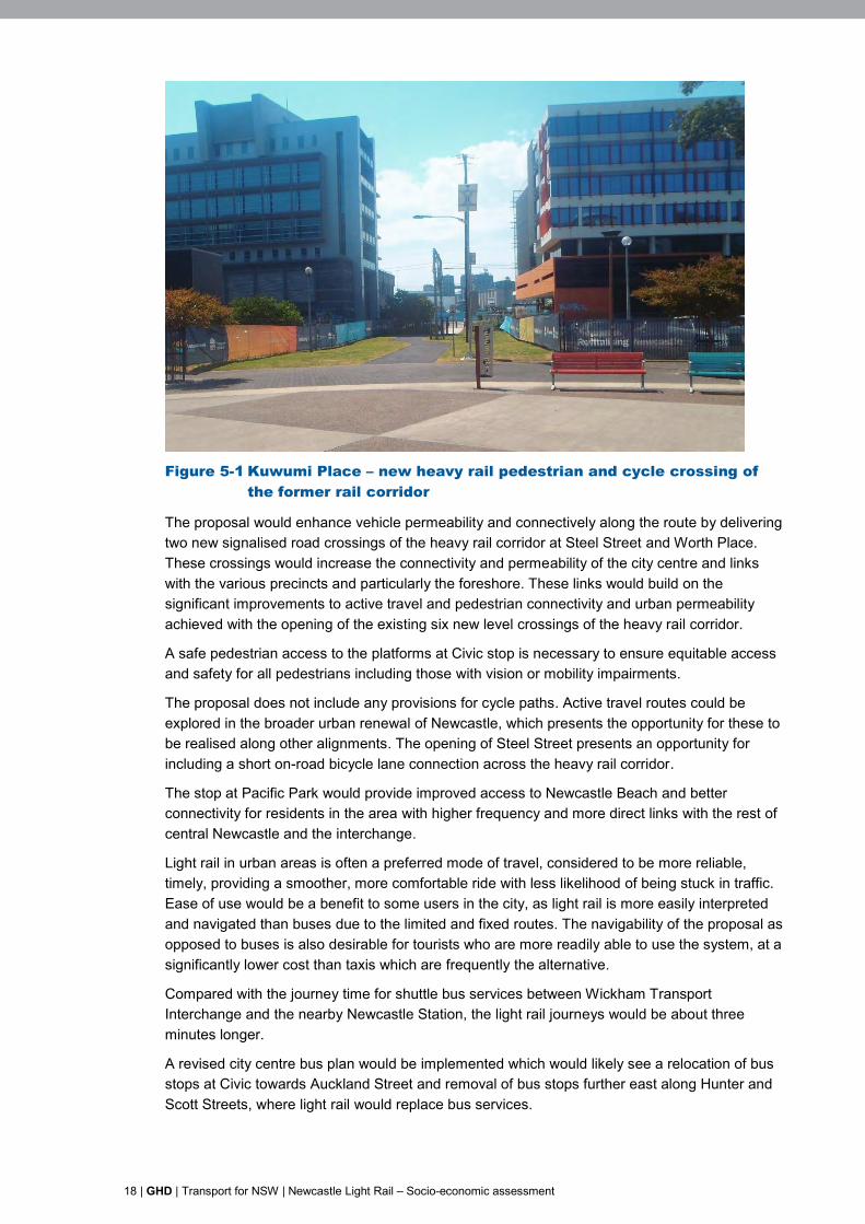
The proposal includes the addition of a number of supporting signalised and pedestrian crossings in connection with the stops. Pedestrian crossings have recently been constructed across the heavy rail corridor at Steel Street, Kuwumi Place, Worth Place, Argyle Street, Perkins Street and Wolfe Street (see Figure 5-1). These would continue to be used following construction of the proposal.
18 | GHD | Transport for NSW | Newcastle Light Rail – Socio-economic assessment
of Figure 5-1 Kuwumi Place – new heavy rail pedestrian and cycle crossing
the former rail corridor
The proposal would enhance vehicle permeability and connectively along the route by delivering two new signalised road crossings of the heavy rail corridor at Steel Street and Worth Place. These crossings would increase the connectivity and permeability of the city centre and links with the various precincts and particularly the foreshore. These links would build on the significant improvements to active travel and pedestrian connectivity and urban permeability achieved with the opening of the existing six new level crossings of the heavy rail corridor.
A safe pedestrian access to the platforms at Civic stop is necessary to ensure equitable access and safety for all pedestrians including those with vision or mobility impairments.
The proposal does not include any provisions for cycle paths. Active travel routes could be explored in the broader urban renewal of Newcastle, which presents the opportunity for these to be realised along other alignments. The opening of Steel Street presents an opportunity for including a short on-road bicycle lane connection across the heavy rail corridor.
The stop at Pacific Park would provide improved access to Newcastle Beach and better connectivity for residents in the area with higher frequency and more direct links with the rest of central Newcastle and the interchange.
Light rail in urban areas is often a preferred mode of travel, considered to be more reliable, timely, providing a smoother, more comfortable ride with less likelihood of being stuck in traffic. Ease of use would be a benefit to some users in the city, as light rail is more easily interpreted and navigated than buses due to the limited and fixed routes. The navigability of the proposal as opposed to buses is also desirable for tourists who are more readily able to use the system, at a significantly lower cost than taxis which are frequently the alternative.
Compared with the journey time for shuttle bus services between Wickham Transport Interchange and the nearby Newcastle Station, the light rail journeys would be about three minutes longer.
A revised city centre bus plan would be implemented which would likely see a relocation of bus stops at Civic towards Auckland Street and removal of bus stops further east along Hunter and Scott Streets, where light rail would replace bus services.
GHD | Transport for NSW | Newcastle Light Rail – Socio-economic assessment | 19
Permanent change to access would occur in Beresford Street, which would change to a one way street in the westerly direction. This change is considered a minor impact for businesses and residents in the street as it would require a relatively minor behavioural change. Access to all residences and businesses would be maintained.
Traffic redistribution would also occur as a result of proposal operation, with traffic likely to divert from Hunter Street to King Street between Union Street and Darby Street. The potential impacts to businesses associated with impacts to on-street parking and loading zones are considered in section 5.2.3.
Affordability is a key consideration, and at the forefront of community concerns in regard to the proposal. In order not to disadvantage users of the previous rail line, fare pricing should consider previous travel costs, as cost increases could discourage business, recreational or service seeking travellers from using the service and potentially seeking alternate destinations or travel modes.
5.2.2 Amenity and aesthetics
Construction
Construction has the potential to negatively impact the amenity and attractiveness of the area as construction passes. Changes in noise, vibration, dust generation, accessibility, appearance and presence of operating plant and equipment all have the potential to impact on local amenity.
Some areas would be more sensitive to construction activities, including:
Beresford Street – longer duration construction of the light rail maintenance and stabling facility, demolition of the former Wickham Station and demolition of the pedestrian bridge. This area is adjacent to two large residential apartment buildings.
Scott Street between Telford and Pacific Streets – high density of residential buildings and high quality existing views and streetscapes.
Visual impacts would be experienced along most of the proposal route in Hunter and Scott streets, and also at the former Wickham Station. However, these impacts would be short term, and would be mitigated by standard design and construction approaches. Impacts would largely be consistent with the existing context of rail and road corridors.
Generally, construction noise and vibration along the proposal route on Hunter and Scott streets is likely to be comparable to that generated by typical road works, and in the heavy rail corridor similar to track maintenance activities previously undertaken during track possessions. Noise and vibration impacts would be managed to acceptable levels with standard construction mitigation measures.
Dust and exhaust emissions from plant and construction equipment would occur during construction, however impacts are likely to be minor. As for noise and vibration, air quality impacts would be managed to acceptable levels with standard construction mitigation measures.
Newcastle has a strong creative, innovative and engaging culture and aspirations to develop these, as evidenced in the Newcastle 2030 Vision and Strategic Plan. Approaches to mitigate the aesthetic impacts of construction works would consider the input of the community and Council. This would include creating opportunities for engagement and expression through artistic treatment of hoardings or other such measures which can deliver social and aesthetic benefit during construction.
20 | GHD | Transport for NSW | Newcastle Light Rail – Socio-economic assessment
Operation
The changes to bus routes and stops and replacement with light rail vehicles may enhance the visual amenity of the city, and support the increasing activation of Newcastle city centre.
The introduction of catenary systems and supporting infrastructure has the potential to impact on visual amenity, however Technical Report 6 – Urban Landscape and Visual Assessment has found these and other operational impacts to be minor. The report also finds that positive visual and landscape impacts are overall low to moderate, whilst the visual and landscape benefits are greater for residential properties along the route.
In general, night time average and maximum noise levels generated by operation of the light rail are anticipated to generally be lower than the existing noise environment due to road vehicle traffic. However there may be potential exceedances of noise criteria in several locations. Potential noise during operation includes:
Wheel squeal where the route makes significant turns.
Passengers congregating at, and moving to and from new light rail stops and public announcement systems.
Noise from light rail vehicle operation (particularly roof mounted air conditioners and sounding of approach bells).
Further assessment during detailed design would enable incorporation of design features to avoid or limit these exceedances.
A change in the nature of noise generated from light rail (e.g. from heavy rail train horns and vehicle traffic, to less familiar light rail bells and operational noise) may result in a perception, due to increased sensitivity, of increased noise.
5.2.3 Business performance
Impacts to businesses would vary in relation to their location along the proposal site, the stage of works, the type of impact, the severity of the impact and the current level of robustness of the business. However, the key consideration is how these changes would alter the performance of the business, most notably turnover and profit.
The sources of potential business impacts are considered below by stage of works to provide a framework for management. The impacts are primarily indirect, with changes to vehicle and pedestrian traffic, parking, noise and general amenity the direct impacts.
The impacts discussed in this section are not limited to businesses, but are also relevant to other organisations such as not for profit and government services. These are also discussed separately in section 5.2.4.
Construction
The key potential impacts on businesses along the proposal site during construction relate to the following:
Access
Changes to access for businesses would result from reduced availability of on-street parking for customers and deliveries. This impact would be more pronounced when the construction zone is immediately adjacent to properties and the most accessible car parking spaces are no longer available. In some instances, these periods of direct exposure to the construction zone would be of a longer duration if construction activities are more complex, for example, for businesses in Beresford Street opposite the light rail maintenance and stabling facility, at light rail stops, and at the Worth Place intersection.

GHD | Transport for NSW | Newcastle Light Rail – Socio-economic assessment | 21
The loss of parking immediately adjacent to businesses would be a temporary inconvenience for most customers and staff. However this loss of adjacent parking would have more impact on customers and staff with limited mobility such as older people, or people with a disability. Access restrictions also have the potential to temporarily increase the time and effort required to undertake business delivery and servicing tasks, thereby potentially increasing costs.
Changes to passing trade
Parking impacts and changes to pedestrian and vehicle traffic as a result of proposal construction has the potential to impact on businesses reliant on passing trade and accessible parking. These impacts would vary as the construction zone moves along the route and, depending on the type of businesses; these impacts could be positive or negative. The proximity of the construction workforce brings the opportunity for increased customer patronage, especially for food and beverage businesses.
Key elements of the construction zones that would influence these impacts are:
Bus stop locations – temporary relocation of bus stops may have a negative impact for businesses in proximity to bus stops which draw patronage from bus passengers (such as take away food shops or newsagents). There is also the potential for these relocations to deliver temporary positive impacts to other similar businesses at and on the path to the relocated bus stops.
Altered pedestrian crossing points – businesses at pedestrian crossing points at either end of construction zones may benefit from increased exposure, whilst those fronting the construction zone may experience less passing trade. For example, take away food shops may experience an increase in demand from construction workers in the area, or may experience reduced demand if the business is less visible.
The changes to passing trade for these businesses would be temporary impacts experienced during the construction period.
A survey of businesses along the alignment would be undertaken prior to construction commencing to gather information on the potential impacts of construction activities on their operations. The survey would seek detailed information from each business, for example, type of business, operating hours, customer behaviours, location of parking and loading areas.
This information would allow the development of specific management measures to ensure that where practicable, the impacts on each business during construction are managed. These management measures would be detailed in a business and organisation management plan (see section 5.2.4).
Amenity
Reduction in aesthetics and amenity during the construction phase, as discussed in section 5.2.2, could potentially discourage customers and clients from visiting the area. This is more likely for businesses relying on pleasant environments for services such as dining, personal services and potentially health services.
Together, the above impacts have the potential to impact on business performance and in some instances could undermine business viability. Some businesses which already face challenges with profitability may be at risk of closure as a result of the additional stresses caused during proposal construction. Conversely, some businesses, such as food and convenience shops may temporarily benefit from improved locations and passing trade. This would be temporary as the construction zones progress along the proposal route.
22 | GHD | Transport for NSW | Newcastle Light Rail – Socio-economic assessment
The survey of businesses would provide more detail on which businesses are likely to be at risk as a result of construction activities. The outcomes of the survey would inform the business and organisation management plan, which would assist businesses to adapt to changed conditions as a result of the proposal.
In addition, a construction communication management plan would be prepared as part of the construction environmental management plan (CEMP) and would include a detailed list of the measures that would be implemented during construction to communicate with and respond to the community and businesses.
Operation
Operation of the proposal would result in altered pedestrian and traffic movement. Light rail stops are likely to replace bus stops as key passenger distribution points. Operation of the proposal, coupled with the increased connectivity afforded by additional heavy rail crossing points, is expected to increase the vibrancy and walkability of the city centre. This may lead to a gradual mode shift for city trips from use of cars to walking and even cycling.
As noted in the traffic, transport and access assessment report, the proposal would result in a reduction in the availability of on-street parking and loading zones.
During operation the main impacts to businesses are likely to be:
Implications for customer parking and business servicing (such as deliveries).
Enhanced business from passing trade due to this increased attraction to and walkability of the city.
It is expected that businesses along the alignment would indirectly benefit in the long term from the enhanced walkability of the city centre as a result of the proposal. The proposal would contribute to the revitalisation of the city centre, which over time is expected to become a more vibrant and attractive area for residents, workers and visitors. Businesses such as retail stores, cafes and restaurants are likely to benefit from increased numbers of people spending time in the city centre.
5.2.4 Social infrastructure
Construction
Access issues discussed in sections 5.2.1 and 5.2.3, and potential amenity issues discussed in section 5.2.2, are particularly relevant for social service providers. Social service providers often serve the most vulnerable in communities, and those with potentially less ability to adapt to changes in their environments and circumstances.
There are 36 social service providers (both public and not for profit) along the proposal route, including personal counselling, employment, health and education services providers2. During construction, these services and their customers/clients may be potentially affected due to access or amenity impacts.
2 GHD field survey, November 2014
GHD | Transport for NSW | Newcastle Light Rail – Socio-economic assessment | 23
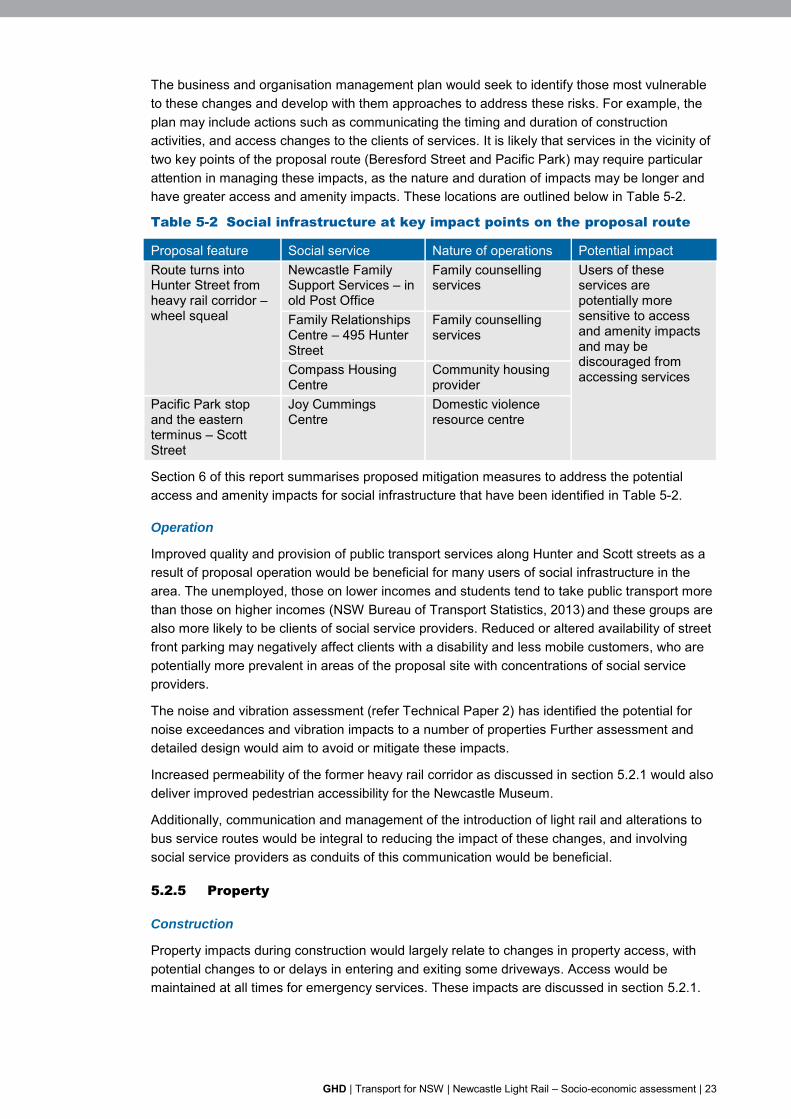
The business and organisation management plan would seek to identify those most vulnerable to these changes and develop with them approaches to address these risks. For example, the plan may include actions such as communicating the timing and duration of construction activities, and access changes to the clients of services. It is likely that services in the vicinity of two key points of the proposal route (Beresford Street and Pacific Park) may require particular attention in managing these impacts, as the nature and duration of impacts may be longer and have greater access and amenity impacts. These locations are outlined below in Table 5-2.
Table 5-2 Social infrastructure at key impact points on the proposal route
Proposal feature Social service Nature of operations Potential impact Route turns into Hunter Street from heavy rail corridor – wheel squeal
Newcastle Family Support Services – in old Post Office
Family counselling services
Users of these services are potentially more sensitive to access and amenity impacts and may be discouraged from accessing services
Family Relationships Centre – 495 Hunter Street
Family counselling services
Compass Housing Centre
Community housing provider
Pacific Park stop and the eastern terminus – Scott Street
Joy Cummings Centre
Domestic violence resource centre
Section 6 of this report summarises proposed mitigation measures to address the potential access and amenity impacts for social infrastructure that have been identified in Table 5-2.
Operation
Improved quality and provision of public transport services along Hunter and Scott streets as a result of proposal operation would be beneficial for many users of social infrastructure in the area. The unemployed, those on lower incomes and students tend to take public transport more than those on higher incomes (NSW Bureau of Transport Statistics, 2013) and these groups are also more likely to be clients of social service providers. Reduced or altered availability of street front parking may negatively affect clients with a disability and less mobile customers, who are potentially more prevalent in areas of the proposal site with concentrations of social service providers.
The noise and vibration assessment (refer Technical Paper 2) has identified the potential for noise exceedances and vibration impacts to a number of properties Further assessment and detailed design would aim to avoid or mitigate these impacts.
Increased permeability of the former heavy rail corridor as discussed in section 5.2.1 would also deliver improved pedestrian accessibility for the Newcastle Museum.
Additionally, communication and management of the introduction of light rail and alterations to bus service routes would be integral to reducing the impact of these changes, and involving social service providers as conduits of this communication would be beneficial.
5.2.5 Property
Construction
Property impacts during construction would largely relate to changes in property access, with potential changes to or delays in entering and exiting some driveways. Access would be maintained at all times for emergency services. These impacts are discussed in section 5.2.1.
24 | GHD | Transport for NSW | Newcastle Light Rail – Socio-economic assessment
Operation
The proposal would require some small areas of land acquisition in several locations. These properties are all government or commercially owned and are listed in chapter 14 of the REF. Acquisition of properties would require negotiation with the property owners. These properties are currently underutilised. The reinvigoration of the Wickham area through the development of the interchange and subsequent urban activation may present other land owners with a unique opportunity to benefit from increased activity and desirable proximity as a transport orientated development.
5.2.6 Land values
Operation
While experience in light rail projects globally have shown resultant increases in land value along the route, this has largely been linked to savings in time and cost for commuting over intermediate distances3. It is unlikely that the proposal would drive route-wide land value changes based on proximity to a light rail network. However retail land values have also been found to rise in the vicinity of light rail stops4. Of note for Newcastle is the high level of vacancy and relatively high incidence of retail shop frontages on Hunter Street being used for commercial (non-retail) uses (Hill PDA 2012). It is unlikely that the proposal alone would noticeably affect demand for these spaces and consequently, affect land values in the short term. Any such change would be a benefit for land owners, and more broadly for growth in the city, though may result in increased costs for tenants and potential displacement.
Appreciating land values and the reciprocal increasing demand for land (e.g. for housing, commercial and other uses) are a desired outcome of the Newcastle Urban Renewal Strategy. However these would be related to the urban renewal which the proposal facilitates, rather than AS part of the proposal itself.
5.2.7 Employment and economy
Construction
Construction of the proposal would generate a number of construction related positions that are likely to be filled both locally and regionally in the Lower Hunter and Sydney. TfNSW is committed to creating local opportunities for employment and upskilling the workforce as an element of their sustainability strategy. It is intended that this requirement would be part of the selection process for a future construction contractor.
Infrastructure investment would also generate multiplier effects in the regional and broader economy creating opportunities in other industries involved in the development and execution of the proposal.
Tourism in Newcastle is a significant contributor locally and regionally (with visitation from the Lower Hunter, and as a component of tourism in the Lower Hunter) and also drawing from further afield. Construction over an extended period (anticipated in the order of 20 months) could potentially negatively impact on tourism in the region during the construction period.
3 CBD and South East Light Rail Economic Assessment. Hill PDA 2014. 4 Ibid.
GHD | Transport for NSW | Newcastle Light Rail – Socio-economic assessment | 25
Operation
A more walkable city centre with a more easily navigable transport system would benefit tourism and recreational visitors to the city. Light rail would contribute to the feel and image of a contemporary and vibrant city. Light rail is also more desirable for tourists who are able to better understand the light rail network and for whom it is a more cost effective option than taxis.
5.2.8 Community safety
There is existing passive surveillance and urban street activity within the proposal site throughout Hunter and Scott streets, due to existing bus and pedestrian traffic. Increased passenger activity at the Pacific Park stop would increase street activity during operation, bringing a positive community benefit. Existing passive surveillance is limited adjacent to the park area, thus night time security at the terminus should be further considered. Additionally, current access to the Wickham Transport Interchange from Hunter Street through Cooper Street presents a potential safety concern being a narrow street with poor surveillance, especially at night.
5.2.9 Summary of impacts
Local impacts described in the preceding sections are summarised in Table 5-3. Mitigation measures to address these identified impacts are described in section 6, including who would be responsible for their implementation.
26 | GHD | Transport for NSW | Newcastle Light Rail – Socio-economic assessment
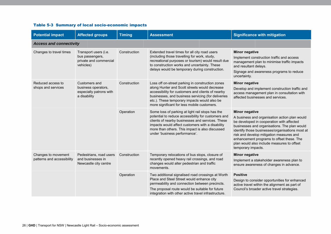
Table 5-3 Summary of local socio-economic impacts
Potential impact Affected groups Timing Assessment Significance with mitigation
Access and connectivity
Changes to travel times
Transport users (i.e. bus passengers, private and commercial vehicles)
Construction Extended travel times for all city road users (including those travelling for work, study, recreational purposes or tourism) would result due to construction works and uncertainty. These delays would be temporary during construction.
Minor negative Implement construction traffic and access management plan to minimise traffic impacts and resultant delays. Signage and awareness programs to reduce uncertainty.
Reduced access to shops and services
Customers and business operators, especially patrons with a disability
Construction Loss off on-street parking in construction zones along Hunter and Scott streets would decrease accessibility for customers and clients of nearby businesses, and business servicing (for deliveries etc.). These temporary impacts would also be more significant for less mobile customers.
Minor negative Develop and implement construction traffic and access management plan in consultation with affected businesses and services.
Operation Some loss of parking at light rail stops has the potential to reduce accessibility for customers and clients of nearby businesses and services. These impacts would affect customers with a disability more than others. This impact is also discussed under ‘business performance’.
Minor negative A business and organisation action plan would be developed in cooperation with affected businesses and organisations. The plan would identify those businesses/organisations most at risk and develop mitigation measures and enhancement programs to offset these. The plan would also include measures to offset temporary impacts.
Changes to movement patterns and accessibility
Pedestrians, road users and businesses in Newcastle city centre
Construction Temporary relocations of bus stops, closure of recently opened heavy rail crossings, and road changes would alter pedestrian and traffic movements.
Minor negative Implement a stakeholder awareness plan to ensure awareness of changes in advance.
Operation Two additional signalised road crossings at Worth Place and Steel Street would enhance city permeability and connection between precincts. The proposal route would be suitable for future integration with other active travel infrastructure.
Positive Design to consider opportunities for enhanced active travel within the alignment as part of Council’s broader active travel strategies.
GHD | Transport for NSW | Newcastle Light Rail – Socio-economic assessment | 27
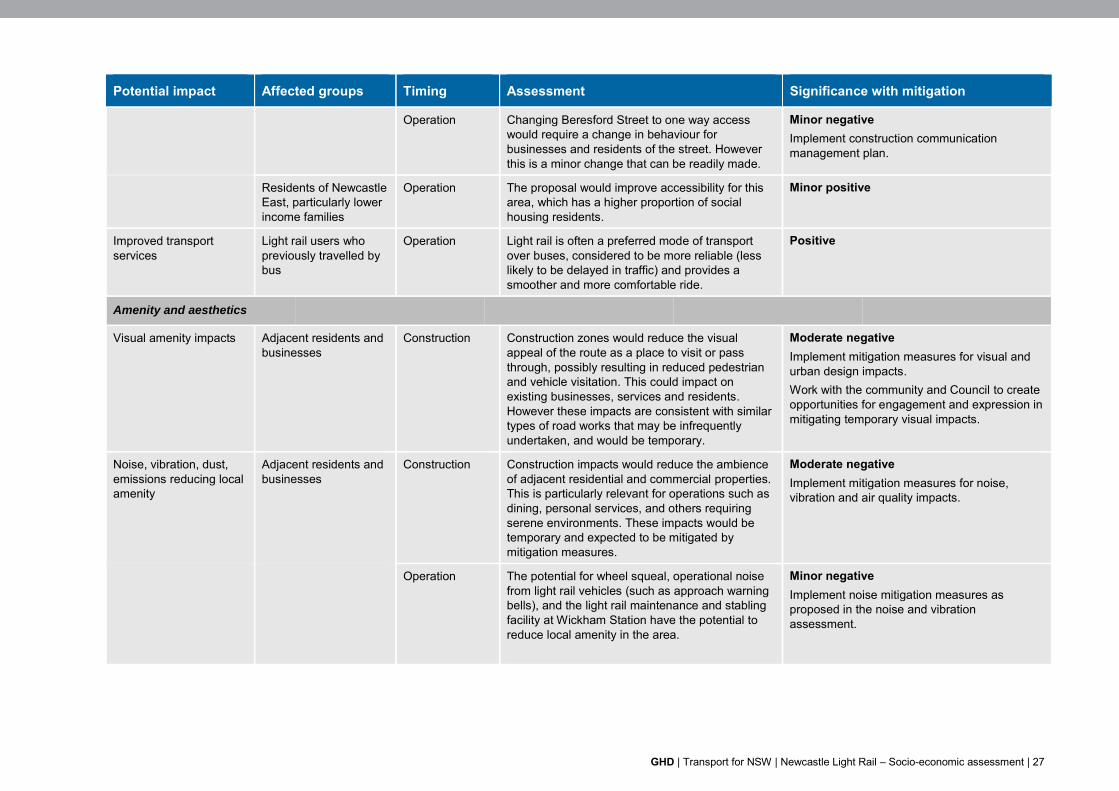
Potential impact Affected groups Timing Assessment Significance with mitigation
Operation Changing Beresford Street to one way access would require a change in behaviour for businesses and residents of the street. However this is a minor change that can be readily made.
Minor negative Implement construction communication management plan.
Residents of Newcastle East, particularly lower income families
Operation The proposal would improve accessibility for this area, which has a higher proportion of social housing residents.
Minor positive
Improved transport services
Light rail users who previously travelled by bus
Operation Light rail is often a preferred mode of transport over buses, considered to be more reliable (less likely to be delayed in traffic) and provides a smoother and more comfortable ride.
Positive
Amenity and aesthetics
Visual amenity impacts Adjacent residents and businesses
Construction Construction zones would reduce the visual appeal of the route as a place to visit or pass through, possibly resulting in reduced pedestrian and vehicle visitation. This could impact on existing businesses, services and residents. However these impacts are consistent with similar types of road works that may be infrequently undertaken, and would be temporary.
Moderate negative Implement mitigation measures for visual and urban design impacts. Work with the community and Council to create opportunities for engagement and expression in mitigating temporary visual impacts.
Noise, vibration, dust, emissions reducing local amenity
Adjacent residents and businesses
Construction Construction impacts would reduce the ambience of adjacent residential and commercial properties. This is particularly relevant for operations such as dining, personal services, and others requiring serene environments. These impacts would be temporary and expected to be mitigated by mitigation measures.
Moderate negative Implement mitigation measures for noise, vibration and air quality impacts.
Operation The potential for wheel squeal, operational noise from light rail vehicles (such as approach warning bells), and the light rail maintenance and stabling facility at Wickham Station have the potential to reduce local amenity in the area.
Minor negative Implement noise mitigation measures as proposed in the noise and vibration assessment.
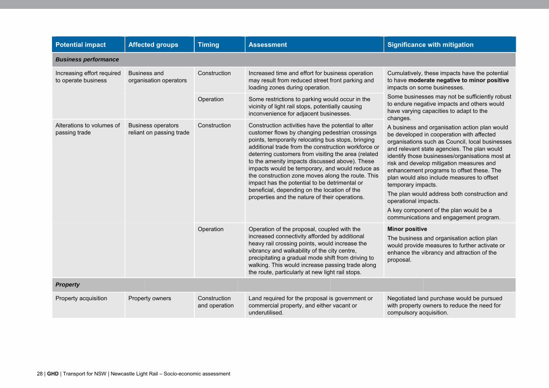
28 | GHD | Transport for NSW | Newcastle Light Rail – Socio-economic assessment
Potential impact Affected groups Timing Assessment Significance with mitigation
Business performance
Increasing effort required to operate business
Business and organisation operators
Construction Increased time and effort for business operation may result from reduced street front parking and loading zones during operation.
Cumulatively, these impacts have the potential to have moderate negative to minor positive impacts on some businesses. Some businesses may not be sufficiently robust to endure negative impacts and others would have varying capacities to adapt to the changes. A business and organisation action plan would be developed in cooperation with affected organisations such as Council, local businesses and relevant state agencies. The plan would identify those businesses/organisations most at risk and develop mitigation measures and enhancement programs to offset these. The plan would also include measures to offset temporary impacts. The plan would address both construction and operational impacts. A key component of the plan would be a communications and engagement program.
Operation Some restrictions to parking would occur in the vicinity of light rail stops, potentially causing inconvenience for adjacent businesses.
Alterations to volumes of passing trade
Business operators reliant on passing trade
Construction Construction activities have the potential to alter customer flows by changing pedestrian crossings points, temporarily relocating bus stops, bringing additional trade from the construction workforce or deterring customers from visiting the area (related to the amenity impacts discussed above). These impacts would be temporary, and would reduce as the construction zone moves along the route. This impact has the potential to be detrimental or beneficial, depending on the location of the properties and the nature of their operations.
Operation Operation of the proposal, coupled with the increased connectivity afforded by additional heavy rail crossing points, would increase the vibrancy and walkability of the city centre, precipitating a gradual mode shift from driving to walking. This would increase passing trade along the route, particularly at new light rail stops.
Minor positive The business and organisation action plan would provide measures to further activate or enhance the vibrancy and attraction of the proposal.
Property
Property acquisition Property owners
Construction and operation
Land required for the proposal is government or commercial property, and either vacant or underutilised.
Negotiated land purchase would be pursued with property owners to reduce the need for compulsory acquisition.
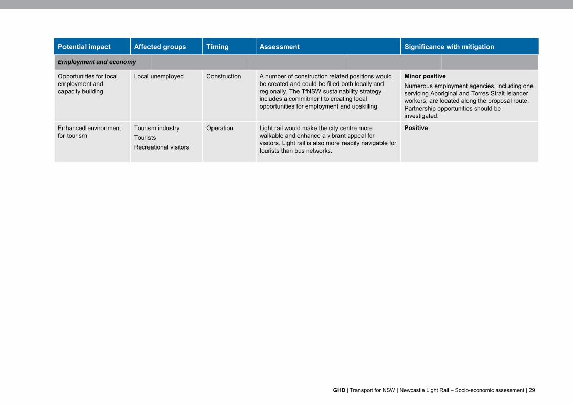
GHD | Transport for NSW | Newcastle Light Rail – Socio-economic assessment | 29
Potential impact Affected groups Timing Assessment Significance with mitigation
Employment and economy
Opportunities for local employment and capacity building
Local unemployed
Construction A number of construction related positions would be created and could be filled both locally and regionally. The TfNSW sustainability strategy includes a commitment to creating local opportunities for employment and upskilling.
Minor positive Numerous employment agencies, including one servicing Aboriginal and Torres Strait Islander workers, are located along the proposal route. Partnership opportunities should be investigated.
Enhanced environment for tourism
Tourism industry Tourists Recreational visitors
Operation Light rail would make the city centre more walkable and enhance a vibrant appeal for visitors. Light rail is also more readily navigable for tourists than bus networks.
Positive
30 | GHD | Transport for NSW | Newcastle Light Rail – Socio-economic assessment
6. Mitigation measures
Measures to mitigate social impacts, additional to those already proposed in other specialist reports (such as those related to traffic, transport and access, and noise and vibration), are listed in Table 6-1. The table identifies the potential impact and the affected stakeholder groups, the timing of the recommended measure, recommended mitigation measures, and the lead agency responsible for implementing the measure. The measures proposed recognise that successful implementation would rely on engagement/partnership with other agencies and stakeholders, particularly Council.
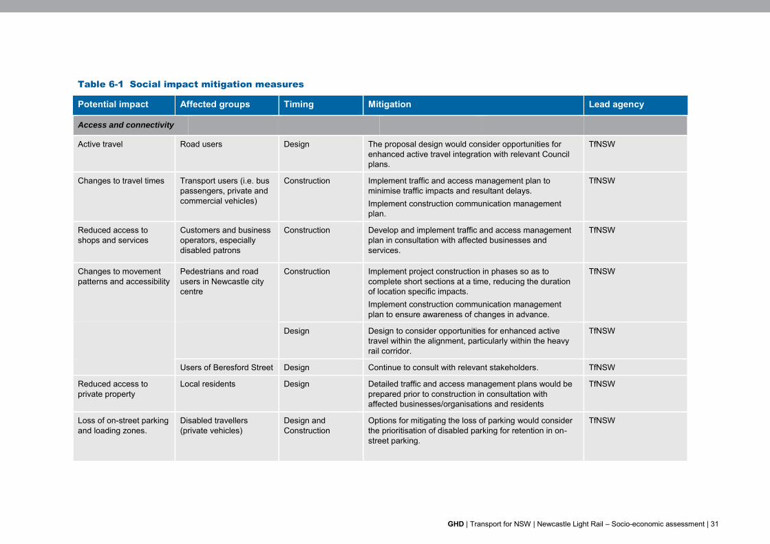
GHD | Transport for NSW | Newcastle Light Rail – Socio-economic assessment | 31
Table 6-1 Social impact mitigation measures
Potential impact Affected groups Timing Mitigation Lead agency
Access and connectivity
Active travel Road users Design The proposal design would consider opportunities for enhanced active travel integration with relevant Council plans.
TfNSW
Changes to travel times
Transport users (i.e. bus passengers, private and commercial vehicles)
Construction Implement traffic and access management plan to minimise traffic impacts and resultant delays. Implement construction communication management plan.
TfNSW
Reduced access to shops and services
Customers and business operators, especially disabled patrons
Construction Develop and implement traffic and access management plan in consultation with affected businesses and services.
TfNSW
Changes to movement patterns and accessibility
Pedestrians and road users in Newcastle city centre
Construction Implement project construction in phases so as to complete short sections at a time, reducing the duration of location specific impacts. Implement construction communication management plan to ensure awareness of changes in advance.
TfNSW
Design Design to consider opportunities for enhanced active travel within the alignment, particularly within the heavy rail corridor.
TfNSW
Users of Beresford Street Design Continue to consult with relevant stakeholders. TfNSW
Reduced access to private property
Local residents Design Detailed traffic and access management plans would be prepared prior to construction in consultation with affected businesses/organisations and residents
TfNSW
Loss of on-street parking and loading zones.
Disabled travellers (private vehicles)
Design and Construction
Options for mitigating the loss of parking would consider the prioritisation of disabled parking for retention in on-street parking.
TfNSW
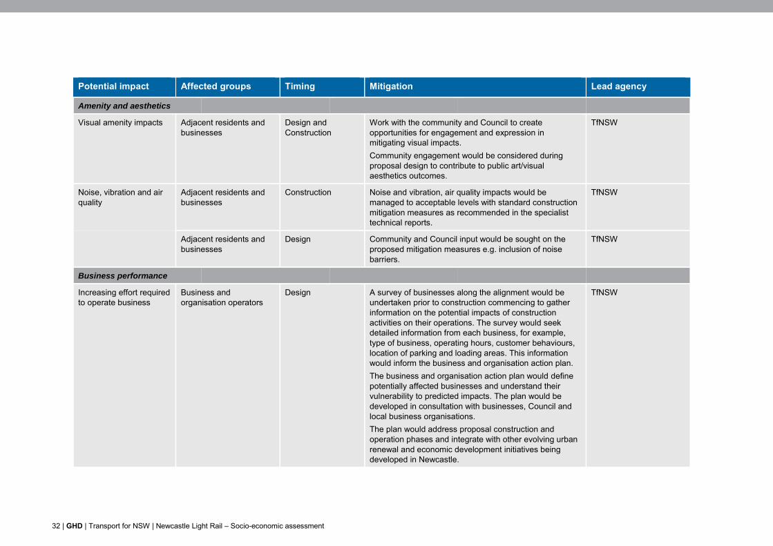
32 | GHD | Transport for NSW | Newcastle Light Rail – Socio-economic assessment
Potential impact Affected groups Timing Mitigation Lead agency
Amenity and aesthetics
Visual amenity impacts Adjacent residents and businesses
Design and Construction
Work with the community and Council to create opportunities for engagement and expression in mitigating visual impacts. Community engagement would be considered during proposal design to contribute to public art/visual aesthetics outcomes.
TfNSW
Noise, vibration and air quality
Adjacent residents and businesses
Construction Noise and vibration, air quality impacts would be managed to acceptable levels with standard construction mitigation measures as recommended in the specialist technical reports.
TfNSW
Adjacent residents and businesses
Design Community and Council input would be sought on the proposed mitigation measures e.g. inclusion of noise barriers.
TfNSW
Business performance
Increasing effort required to operate business
Business and organisation operators
Design A survey of businesses along the alignment would be undertaken prior to construction commencing to gather information on the potential impacts of construction activities on their operations. The survey would seek detailed information from each business, for example, type of business, operating hours, customer behaviours, location of parking and loading areas. This information would inform the business and organisation action plan. The business and organisation action plan would define potentially affected businesses and understand their vulnerability to predicted impacts. The plan would be developed in consultation with businesses, Council and local business organisations. The plan would address proposal construction and operation phases and integrate with other evolving urban renewal and economic development initiatives being developed in Newcastle.
TfNSW
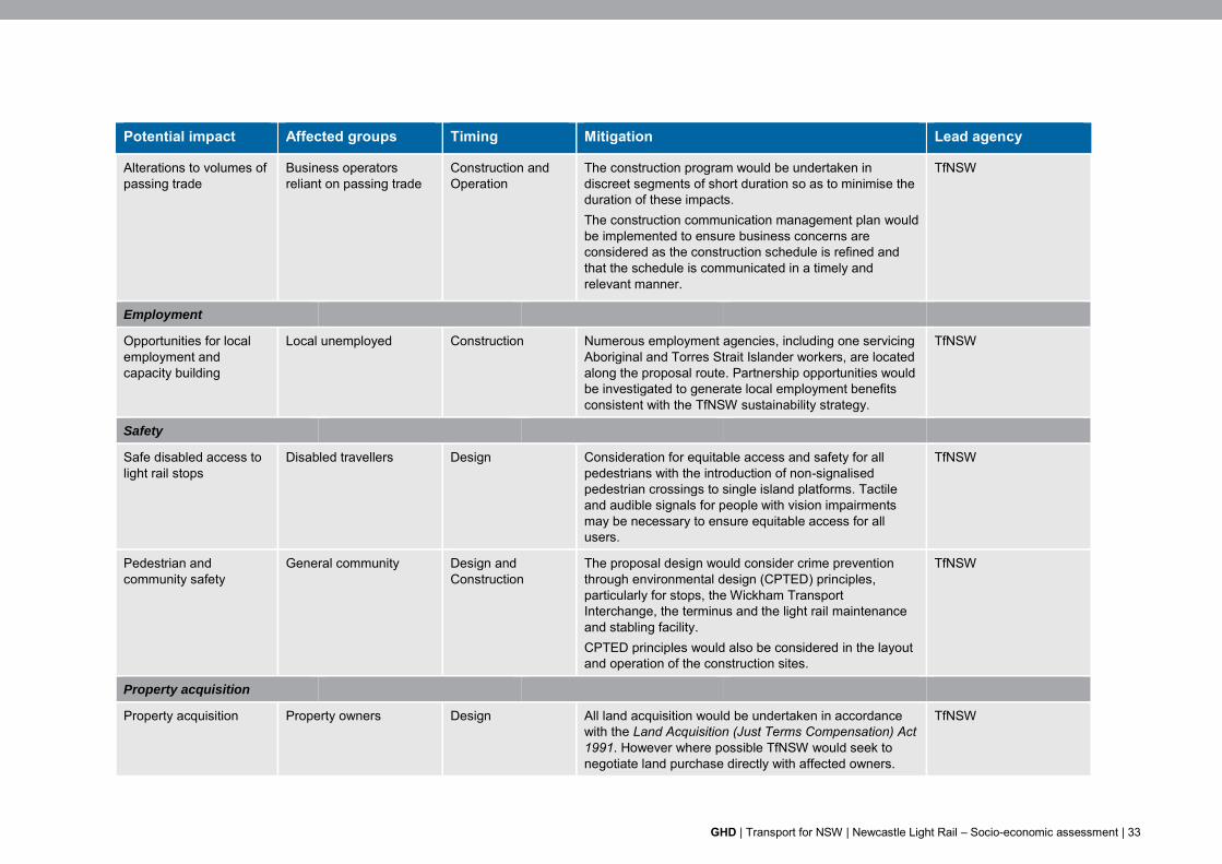
GHD | Transport for NSW | Newcastle Light Rail – Socio-economic assessment | 33
Potential impact Affected groups Timing Mitigation Lead agency
Alterations to volumes of passing trade
Business operators reliant on passing trade
Construction and Operation
The construction program would be undertaken in discreet segments of short duration so as to minimise the duration of these impacts. The construction communication management plan would be implemented to ensure business concerns are considered as the construction schedule is refined and that the schedule is communicated in a timely and relevant manner.
TfNSW
Employment
Opportunities for local employment and capacity building
Local unemployed
Construction Numerous employment agencies, including one servicing Aboriginal and Torres Strait Islander workers, are located along the proposal route. Partnership opportunities would be investigated to generate local employment benefits consistent with the TfNSW sustainability strategy.
TfNSW
Safety
Safe disabled access to light rail stops
Disabled travellers
Design Consideration for equitable access and safety for all pedestrians with the introduction of non-signalised pedestrian crossings to single island platforms. Tactile and audible signals for people with vision impairments may be necessary to ensure equitable access for all users.
TfNSW
Pedestrian and community safety
General community
Design and Construction
The proposal design would consider crime prevention through environmental design (CPTED) principles, particularly for stops, the Wickham Transport Interchange, the terminus and the light rail maintenance and stabling facility. CPTED principles would also be considered in the layout and operation of the construction sites.
TfNSW
Property acquisition
Property acquisition Property owners Design All land acquisition would be undertaken in accordance with the Land Acquisition (Just Terms Compensation) Act 1991. However where possible TfNSW would seek to negotiate land purchase directly with affected owners.
TfNSW
34 | GHD | Transport for NSW | Newcastle Light Rail – Socio-economic assessment
7. Conclusion
The proposal is a key infrastructure element in the Newcastle Urban Renewal Strategy (Department of Planning and Infrastructure, 2012) and the NUTTP. The proposal would facilitate urban redevelopment of public, residential and commercial lands by providing an efficient and accessible form of transport for Newcastle city centre. The truncation of the heavy rail at Wickham and development of the new transport interchange at Stewart Avenue is an important precursor. This has already resulted in improved connectivity in the city with six new pedestrian and cycle crossings across the heavy rail corridor improving access to the foreshore.
This assessment has identified socio-economic benefits and impacts during construction and operation of the proposal and proposes mitigation measures to reduce identified impacts.
The key construction impacts relate to access and amenity, which have the potential to impact residents, businesses and other service providers along the route. These construction impacts may also affect road users and pedestrians.
Operation of the proposal would deliver the benefits of improved connectivity and permeability of the city and increased quality and diversity of transport services. This would contribute to an overall enhanced amenity for the city centre and facilitate successful urban renewal.
Key impacts are summarised as:
Extended travel times due to traffic congestion and uncertainty associated with construction works for all road users in the vicinity.
Reduced access to shops and services for customers and operators due to loss of parking during construction and operation.
A combination of access changes, traffic delays, and amenity impacts (noise, vibration, dust, emissions, visual) could have negative impacts on the community and some businesses.
Mitigation measures are proposed to avoid or reduce these and other potentially adverse impacts.
GHD | Transport for NSW | Newcastle Light Rail – Socio-economic assessment | 35
8. References
Australian Bureau of Statistics (ABS) 2011, Census of Population and Housing
Hill PDA 2012. Newcastle Urban Renewal Study - Economic Assessment 2012. Prepared by for NSW Department of Planning & Infrastructure March 2012
Hill PDA 2014, CBD and South East Light Rail Economic Assessment
Newcastle City Council, Newcastle employment by industry, viewed 23 March 2015, http://www.economicprofile.com.au/newcastle/economy/employment
Newcastle City Council 2013, June, Newcastle Destination Management Plan - Growing Newcastle visitor economy
Newcastle City Council 2014, Draft Local Planning Strategy
Newcastle City Council 2014, Draft Newcastle Economic Development Strategy
Newcastle City Council 2015, Affordable Housing Strategy
Newcastle City Council 2015, Community Vision and Strategic Plan – Newcastle 2030
NSW Bureau of Crime Statistics and Research (BOCSAR), NSW Recorded Crime Statistics, 2014-488323-3
NSW Bureau of Crime Statistics and Research (BOCSAR), NSW Crime tool, viewed 24 September 2015, http://crimetool.bocsar.nsw.gov.au/bocsar/
NSW Bureau of Transport Statistics 2013. Household Travel Survey Report: Sydney 2012/2013.
NSW Bureau of Transport Statistics, Household Travel Survey 2011/2012 Electronic Publication No. D2013-HTS-Table4-Linked
NSW Department of Planning 2011, Hunter Regional Action Plan 2021
NSW Department of Planning and Infrastructure 2012, Newcastle Urban Renewal Strategy 2012
NSW Department of Planning and Environment 2014, Newcastle Urban Renewal Strategy 2014 update
NSW Department of Planning and Environment 2015, Draft Plan for Growing Hunter City
NSW Government Communities, Office of the Director General 2011, Newcastle/Hamilton Precinct Liquor Accord
NSW Government Bureau of Transport Statistics 2013, 2013 Household Travel Survey (HTS) Electronic Publication No. D2013-HTS-Table2-Linked
NSW Government, 2015, Draft Plan for Growing Hunter City, November 2015
Transport for NSW (TfNSW) 2012, NSW Sustainability Design Guidelines – Rail
TfNSW, 2014, Hunter Regional Transport Plan, March 2014
UrbanGrowth NSW 2014, Newcastle Urban Transformation and Transport Program
UrbanGrowth NSW 2014, Revitalising Newcastle: Light Rail from Wickham to the beach – Consultation Report. April 2014 (prepared by Elton)
UrbanGrowth NSW 2014, Design Newcastle - Engagement to support the Newcastle Urban Renewal and Transport Program. August 2014 (prepared by AECOM)
UrbanGrowth NSW 2014, Design Newcastle – A report on what the community told us. July 26-27 2014
GHD | Report for Transport for NSW - Newcastle Light Rail, 22/17478
Appendices

GHD | Report for Transport for NSW - Newcastle Light Rail, 22/17478
Appendix A – Socio-economic profile

GHD | Report for Transport for NSW - Newcastle Light Rail, 22/17478
Profile of local area
This section provides an overview of residents living in the Newcastle city centre. The profile builds a picture of the community that would potentially be affected by the proposal and provides demographic indicators that can be used to predict different impacts and responses to impacts. Data on the Greater Newcastle region is also provided for comparison and to identify those in the wider area that may be indirectly affected by the proposal. Data reviewed to prepare the profile is provided in B.
Overall population
The total population of the Newcastle city centre in 2011 was 3,966 people. The average age was 35 with roughly 31 per cent of the population aged 50 years or over and 15 per cent aged between 18 and 24 years (referred to as young independents).
Consistent with the generally younger population, the Newcastle city centre has low levels of people requiring assistance (3.2 per cent) compared to the Greater Newcastle region (5.9 per cent) (ABS 2011).
Cultural diversity
There is a lower proportion of Indigenous people living in the Newcastle city centre (2.6 per cent) compared to the Greater Newcastle region (3.1 per cent).
People from non-English speaking backgrounds are twice as likely to live in the Newcastle city centre (10.1 per cent) compared to the Greater Newcastle (4.1 per cent). This is likely influenced by higher proportions of overseas students who prefer to live in the inner city (ABS 2011).
Households and families
Compared with the Greater Newcastle region and the Newcastle LGA, the Newcastle city centre has a significantly different demographic, with a much higher incidence of lone person and group households and couples without children. This is illustrated in Figure A-1. These household types reflect the high numbers of students, young families without children, and empty-nesters/retirees in the Newcastle city centre who have been attracted to inner city living.
0%
10%
20%
30%
40%
50%
60%
70%
80%
90%
100%
NewcastleCentre
NewcastleLGA
GreaterNewcastle
Other family
One parent family
Couple family withoutchildren
Couple family withchildren
Group household
Lone person household
Source: ABS 2011, Census of Population and Housing
Figure A-1 Household composition in the local and regional area
GHD | Report for Transport for NSW - Newcastle Light Rail, 22/17478
Dwellings and tenure
The most common dwelling types in the Newcastle city centre are units and apartments (66.2 per cent) with a significantly lower proportion of separate houses (7.1 per cent) and semi-detached or town houses (7.7 per cent), consistent with an inner urban area.
The rate of home ownership is lower in the Newcastle city centre (20.1 per cent) compared to the Newcastle LGA (24.9 per cent). This reflects a higher proportion of renters in the city centre (60 per cent) compared to the Newcastle LGA as a whole (27.3 per cent) (ABS 2011).
Employment and education
Incomes in the Newcastle city centre are significantly higher than the Greater Newcastle region. Average individual incomes in the city centre are $790 per week, compared to individual incomes in the Greater Newcastle region of $544 per week.
The rate of participation in the labour force in the Newcastle city centre is marginally higher (63.9 per cent), and rates of unemployment significantly lower (4.6 per cent), than for the LGA as a whole (60.5 per cent and 5.7 per cent respectfully) and Greater Newcastle region (59.5 per cent and 5.4 per cent respectfully).
The proportion of people working as managers and professionals in the city centre (52 per cent) is significantly higher than for the LGA as a whole (35.6 per cent) and Greater Newcastle (30.8 per cent).
The above results and higher levels of educational attainment in the city centre are consistent with the high numbers of students and concentration of professionals in the city centre.
Higher education is significantly higher in the Newcastle city centre compared to the Newcastle LGA and Greater Newcastle region. Persons who have completed their Year 12 studies (or equivalent) are at 61.5 per cent in the Newcastle city centre, 44.7 per cent in the Newcastle LGA and 37.8 per cent in the Greater Newcastle region. Furthermore, those without post-school qualifications is significantly lower in the Newcastle city centre (29.9 per cent) compared the Newcastle LGA (42.7 per cent) and Greater Newcastle region (44.6 per cent) (ABS 2011).
Mobility
Over half the workers who chose one mode of transport to work travelled by car. However the proportion for the Newcastle city centre (65.2 per cent) is slightly less than that for NSW (71.3 per cent) and significantly less than for the Newcastle LGA (82.9 per cent).
Newcastle city centre residents have lower levels of car ownership (83.4 per cent) and car use for work journeys, and also higher levels of walking and cycling than the Newcastle LGA (88.1 per cent) and Greater Newcastle region (91 per cent) (ABS 2011).
Socio-economic index
The index of relative socio-economic advantage and disadvantage (known as the socio-economic index for areas or SEIFA) is a continuum of advantage (high values) to disadvantage (low values), which is derived from census variables related to both advantage and disadvantage, such as households with low income and people with a tertiary education.
The 2011 index of relative socio-economic disadvantage for suburbs in the study area is presented in Table A-1. The table illustrates the relatively higher levels of disadvantage of residents in Newcastle East and Newcastle West on the outskirts of the city centre.
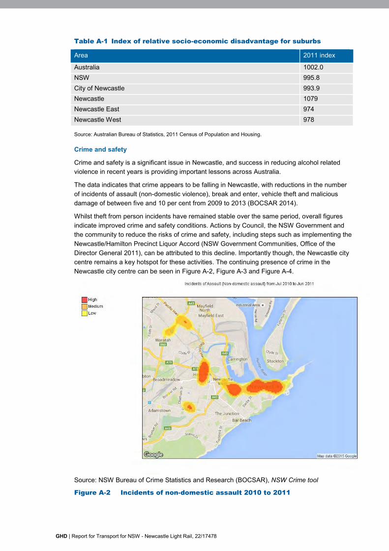
GHD | Report for Transport for NSW - Newcastle Light Rail, 22/17478
Table A-1 Index of relative socio-economic disadvantage for suburbs
Area 2011 index
Australia 1002.0 NSW 995.8 City of Newcastle 993.9 Newcastle 1079 Newcastle East 974 Newcastle West 978
Source: Australian Bureau of Statistics, 2011 Census of Population and Housing.
Crime and safety
Crime and safety is a significant issue in Newcastle, and success in reducing alcohol related violence in recent years is providing important lessons across Australia.
The data indicates that crime appears to be falling in Newcastle, with reductions in the number of incidents of assault (non-domestic violence), break and enter, vehicle theft and malicious damage of between five and 10 per cent from 2009 to 2013 (BOCSAR 2014).
Whilst theft from person incidents have remained stable over the same period, overall figures indicate improved crime and safety conditions. Actions by Council, the NSW Government and the community to reduce the risks of crime and safety, including steps such as implementing the Newcastle/Hamilton Precinct Liquor Accord (NSW Government Communities, Office of the Director General 2011), can be attributed to this decline. Importantly though, the Newcastle city centre remains a key hotspot for these activities. The continuing presence of crime in the Newcastle city centre can be seen in Figure A-2, Figure A-3 and Figure A-4.
Source: NSW Bureau of Crime Statistics and Research (BOCSAR), NSW Crime tool
Figure A-2 Incidents of non-domestic assault 2010 to 2011
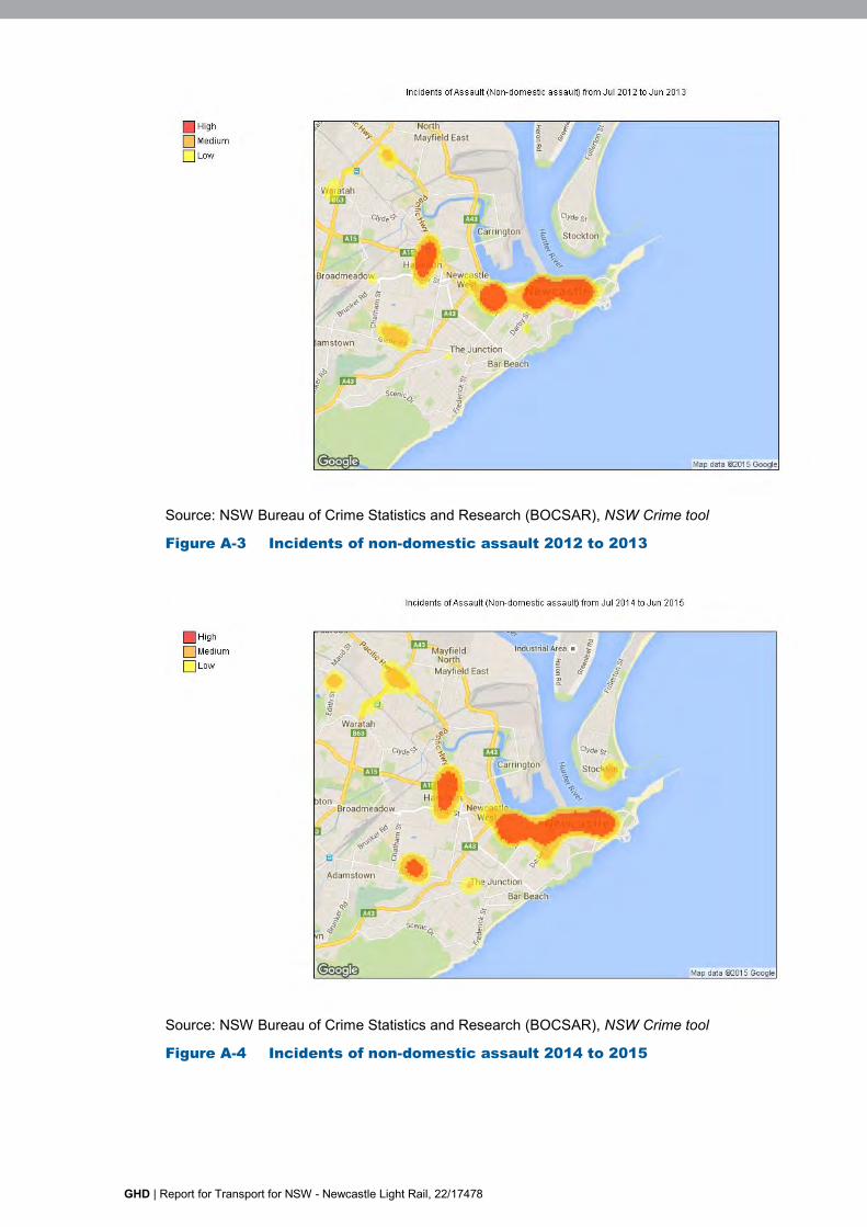
GHD | Report for Transport for NSW - Newcastle Light Rail, 22/17478
Source: NSW Bureau of Crime Statistics and Research (BOCSAR), NSW Crime tool
Figure A-3 Incidents of non-domestic assault 2012 to 2013
Source: NSW Bureau of Crime Statistics and Research (BOCSAR), NSW Crime tool
Figure A-4 Incidents of non-domestic assault 2014 to 2015
GHD | Report for Transport for NSW - Newcastle Light Rail, 22/17478
Social infrastructure
Newcastle is an important location for both local and regional social infrastructure, providing various services and facilities. Community facilities, service providers and community organisations within the vicinity of the proposal site are listed in Appendix C.
Within the vicinity of the proposal site there are several local/regional offices of various State government departments, such as Aboriginal Affairs, the Office of Environment and Heritage and the Department of Planning and Environment, located on Honeysuckle Drive (to the north of the heavy rail corridor). Hunter Street is the location of NSW Health and numerous employment, medical and allied health services and community organisations, with some also located in Scott Street. Federal government social services (Centrelink and Medicare) are located in King Street.
Public spaces around the Newcastle foreshore provide a location for a number of large events. Annual New Year’s Eve celebrations and the ‘Fat as Butter’ music festival are the largest of these, though other events such as gatherings on Anzac Day, also use this area. These events require additional transport planning as the crowds exceed regular transport capacity.
Economy
Newcastle city centre
The Newcastle LGA plays a central role in the Hunter Region as the ‘regional capital’, as it:
Is the centre for critical infrastructure (including the port and support facilities)?
Provides services to the region including health, higher education, financial services, professional services and government services.
Is the headquarters of a number of major organisations?
Has a high concentration of manufacturing/engineering businesses that are servicing national and international markets.
Has a significant knowledge of industries sector.
While manufacturing remains an important sector in Newcastle, even since the closure of BHP in 1999 (which generated almost 10 per cent of jobs in Newcastle LGA at that time), the regional service role of the city has expanded (in areas such as health, business and government services). Manufacturing continues to contribute almost one quarter of Newcastle’s economic output, but less than 10 per cent of employment. Conversely more than 36 per cent of employment is generated by social assistance, education and retail industries together which only represent 13 per cent of output (ABS 2011).
The major changes in employment between 2006 and 2011 were growth in services (business services and in-person services, particularly health and education) and a decline in some areas of manufacturing, retail and services (ABS 2006, ABS 2011).
The tourism sector is growing and Newcastle attracts over 3.3 million visitors per year. Currently, visitors to Newcastle inject around $722 million of direct expenditure into Newcastle's economy annually and over $1.3 billion of indirect expenditure across key industry sectors including retail, transport and education, equating to over 10,000 jobs. Newcastle has become a vibrant stopover for cruise ships carrying domestic and international passengers along the east coast of Australia (Newcastle City Council 2013, pg. 2).
Newcastle is also characterised by a creative and innovation culture that is supporting various business opportunities across the LGA.
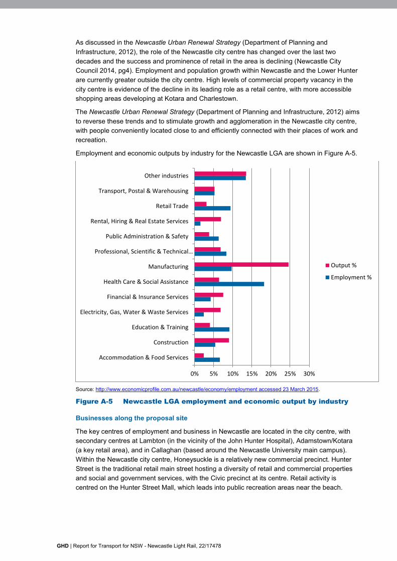
GHD | Report for Transport for NSW - Newcastle Light Rail, 22/17478
As discussed in the Newcastle Urban Renewal Strategy (Department of Planning and Infrastructure, 2012), the role of the Newcastle city centre has changed over the last two decades and the success and prominence of retail in the area is declining (Newcastle City Council 2014, pg4). Employment and population growth within Newcastle and the Lower Hunter are currently greater outside the city centre. High levels of commercial property vacancy in the city centre is evidence of the decline in its leading role as a retail centre, with more accessible shopping areas developing at Kotara and Charlestown.
The Newcastle Urban Renewal Strategy (Department of Planning and Infrastructure, 2012) aims to reverse these trends and to stimulate growth and agglomeration in the Newcastle city centre, with people conveniently located close to and efficiently connected with their places of work and recreation.
Employment and economic outputs by industry for the Newcastle LGA are shown in Figure A-5.
Source: http://www.economicprofile.com.au/newcastle/economy/employment accessed 23 March 2015.
Figure A-5 Newcastle LGA employment and economic output by industry
Businesses along the proposal site
The key centres of employment and business in Newcastle are located in the city centre, with secondary centres at Lambton (in the vicinity of the John Hunter Hospital), Adamstown/Kotara (a key retail area), and in Callaghan (based around the Newcastle University main campus). Within the Newcastle city centre, Honeysuckle is a relatively new commercial precinct. Hunter Street is the traditional retail main street hosting a diversity of retail and commercial properties and social and government services, with the Civic precinct at its centre. Retail activity is centred on the Hunter Street Mall, which leads into public recreation areas near the beach.
0% 5% 10% 15% 20% 25% 30%
Accommodation & Food Services
Construction
Education & Training
Electricity, Gas, Water & Waste Services
Financial & Insurance Services
Health Care & Social Assistance
Manufacturing
Professional, Scientific & Technical…
Public Administration & Safety
Rental, Hiring & Real Estate Services
Retail Trade
Transport, Postal & Warehousing
Other industries
Output %
Employment %
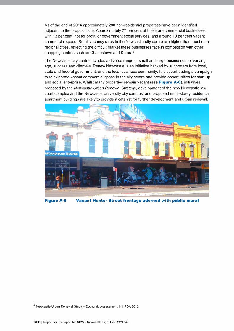
GHD | Report for Transport for NSW - Newcastle Light Rail, 22/17478
As of the end of 2014 approximately 280 non-residential properties have been identified adjacent to the proposal site. Approximately 77 per cent of these are commercial businesses, with 13 per cent ‘not for profit’ or government social services, and around 10 per cent vacant commercial space. Retail vacancy rates in the Newcastle city centre are higher than most other regional cities, reflecting the difficult market these businesses face in competition with other shopping centres such as Charlestown and Kotara5.
The Newcastle city centre includes a diverse range of small and large businesses, of varying age, success and clientele. Renew Newcastle is an initiative backed by supporters from local, state and federal government, and the local business community. It is spearheading a campaign to reinvigorate vacant commercial space in the city centre and provide opportunities for start-up and social enterprise. Whilst many properties remain vacant (see Figure A-6), initiatives proposed by the Newcastle Urban Renewal Strategy, development of the new Newcastle law court complex and the Newcastle University city campus, and proposed multi-storey residential apartment buildings are likely to provide a catalyst for further development and urban renewal.
Figure A-6 Vacant Hunter Street frontage adorned with public mural
5 Newcastle Urban Renewal Study – Economic Assessment. Hill PDA 2012
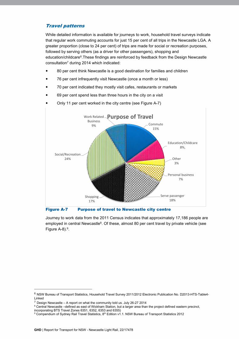
GHD | Report for Transport for NSW - Newcastle Light Rail, 22/17478
Travel patterns
While detailed information is available for journeys to work, household travel surveys indicate that regular work commuting accounts for just 15 per cent of all trips in the Newcastle LGA. A greater proportion (close to 24 per cent) of trips are made for social or recreation purposes, followed by serving others (as a driver for other passengers), shopping and education/childcare6.These findings are reinforced by feedback from the Design Newcastle consultation7 during 2014 which indicated:
80 per cent think Newcastle is a good destination for families and children
76 per cent infrequently visit Newcastle (once a month or less)
70 per cent indicated they mostly visit cafes, restaurants or markets
69 per cent spend less than three hours in the city on a visit
Only 11 per cent worked in the city centre (see Figure A-7)
Figure A-7 Purpose of travel to Newcastle city centre
Journey to work data from the 2011 Census indicates that approximately 17,186 people are employed in central Newcastle8. Of these, almost 80 per cent travel by private vehicle (see Figure A-8).9.
6 NSW Bureau of Transport Statistics, Household Travel Survey 2011/2012 Electronic Publication No. D2013-HTS-Table4-Linked 7 Design Newcastle – A report on what the community told us. July 26-27 2014 8 Central Newcastle –defined as east of Wickham Station, but a larger area than the project defined eastern precinct, incorporating BTS Travel Zones 6351, 6352, 6353 and 6355) 9 Compendium of Sydney Rail Travel Statistics, 8th Edition v1.1. NSW Bureau of Transport Statistics 2012
Commute15%
Education/Childcare8%,
Other3%
Personal business7%
Serve passenger18%
Shopping17%
Social/Recreation24%
Work Related Business
9%
Purpose of Travel
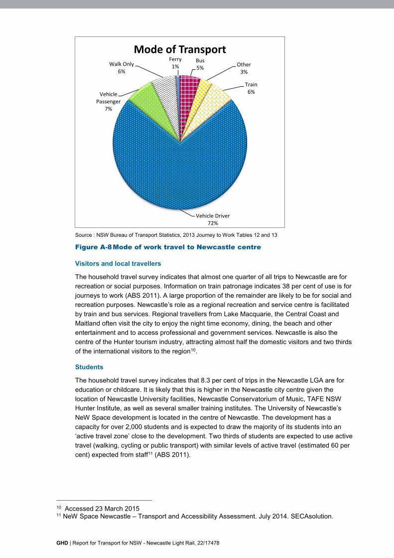
GHD | Report for Transport for NSW - Newcastle Light Rail, 22/17478
Source : NSW Bureau of Transport Statistics, 2013 Journey to Work Tables 12 and 13
Figure A-8 Mode of work travel to Newcastle centre
Visitors and local travellers
The household travel survey indicates that almost one quarter of all trips to Newcastle are for recreation or social purposes. Information on train patronage indicates 38 per cent of use is for journeys to work (ABS 2011). A large proportion of the remainder are likely to be for social and recreation purposes. Newcastle’s role as a regional recreation and service centre is facilitated by train and bus services. Regional travellers from Lake Macquarie, the Central Coast and Maitland often visit the city to enjoy the night time economy, dining, the beach and other entertainment and to access professional and government services. Newcastle is also the centre of the Hunter tourism industry, attracting almost half the domestic visitors and two thirds of the international visitors to the region10.
Students
The household travel survey indicates that 8.3 per cent of trips in the Newcastle LGA are for education or childcare. It is likely that this is higher in the Newcastle city centre given the location of Newcastle University facilities, Newcastle Conservatorium of Music, TAFE NSW Hunter Institute, as well as several smaller training institutes. The University of Newcastle’s NeW Space development is located in the centre of Newcastle. The development has a capacity for over 2,000 students and is expected to draw the majority of its students into an ‘active travel zone’ close to the development. Two thirds of students are expected to use active travel (walking, cycling or public transport) with similar levels of active travel (estimated 60 per cent) expected from staff11 (ABS 2011).
10 Accessed 23 March 2015 11 NeW Space Newcastle – Transport and Accessibility Assessment. July 2014. SECAsolution.
Bus5%
Other3%
Train6%
Vehicle Driver72%
Vehicle Passenger
7%
Walk Only6%
Ferry1%
Mode of Transport
GHD | Report for Transport for NSW - Newcastle Light Rail, 22/17478
Cyclists and pedestrians
Of all travel in Newcastle LGA, an estimated 15 per cent of trips are made by walking, with around three per cent by other modes (including cycling, taxi and ferry).
Travel to work, in the forms of cycling and walking are relatively common in the Newcastle city centre and Newcastle LGA. In comparison to the NSW state average (0.7 per cent), travel to work by means of cycling in the Newcastle LGA (2.1 per cent) is significantly increased with a further increase in the Newcastle city centre (2.6 per cent) (ABS 2011).
The Newcastle city centre bicycle network currently skirts the centre, travelling along the foreshore and linking into other areas of the city including the use of the new crossings over the heavy rail corridor.
Summary of socio-economic profile
Key socio-economic features of the study area are summarised as:
Population of about 4,000 people in 2011.
Demographic - Newcastle city centre has a significantly different demographic, with a much higher incidence of lone person households, couples without children and group households compared with other areas of Newcastle and the region.
Small households – primarily made up of lone households and couples without children, who are more likely to be renting than paying off a mortgage and living in apartments and semi-detached dwellings.
Lower levels of disadvantage – generally high incomes, low rates of unemployment, a labour force consisting of high numbers of professionals and managers, and high levels of education.
Newcastle city centre is an important location for both local and regional infrastructure with many services and facilities.
Whilst Newcastle is growing, this growth is not occurring in the city centre.
Regular work commuting accounts for just a small portion of all trips to Newcastle LGA.
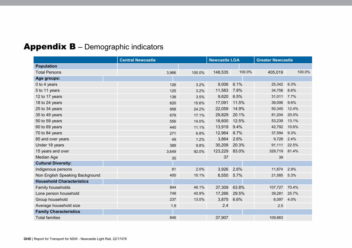
GHD | Report for Transport for NSW - Newcastle Light Rail, 22/17478
Appendix B – Demographic indicators Central Newcastle Newcastle LGA Greater Newcastle Population Total Persons 3,966 100.0% 148,535 100.0% 405,019 100.0% Age groups: 0 to 4 years 126 3.2% 9,006 6.1% 25,342 6.3% 5 to 11 years 125 3.2% 11,583 7.8% 34,758 8.6% 12 to 17 years 138 3.5% 9,620 6.5% 31,011 7.7% 18 to 24 years 620 15.6% 17,091 11.5% 39,006 9.6% 25 to 34 years 958 24.2% 22,059 14.9% 50,345 12.4% 35 to 49 years 679 17.1% 29,829 20.1% 81,204 20.0% 50 to 59 years 556 14.0% 18,600 12.5% 53,239 13.1% 60 to 69 years 440 11.1% 13,919 9.4% 42,792 10.6% 70 to 84 years 271 6.8% 12,964 8.7% 37,594 9.3% 85 and over years 49 1.2% 3,864 2.6% 9,728 2.4% Under 18 years 389 9.8% 30,209 20.3% 91,111 22.5% 15 years and over 3,649 92.0% 123,229 83.0% 329,719 81.4% Median Age 35 37 39 Cultural Diversity: Indigenous persons 81 2.0% 3,926 2.6% 11,874 2.9% Non English Speaking Background 400 10.1% 8,550 5.7% 21,585 5.3% Household Characteristics Family households 844 46.1% 37,309 63.8% 107,727 70.4% Lone person household 749 40.9% 17,266 29.5% 39,281 25.7% Group household 237 13.0% 3,875 6.6% 6,097 4.0% Average household size 1.9 2.4 2.5 Family Characteristics Total families 846 37,907 109,883
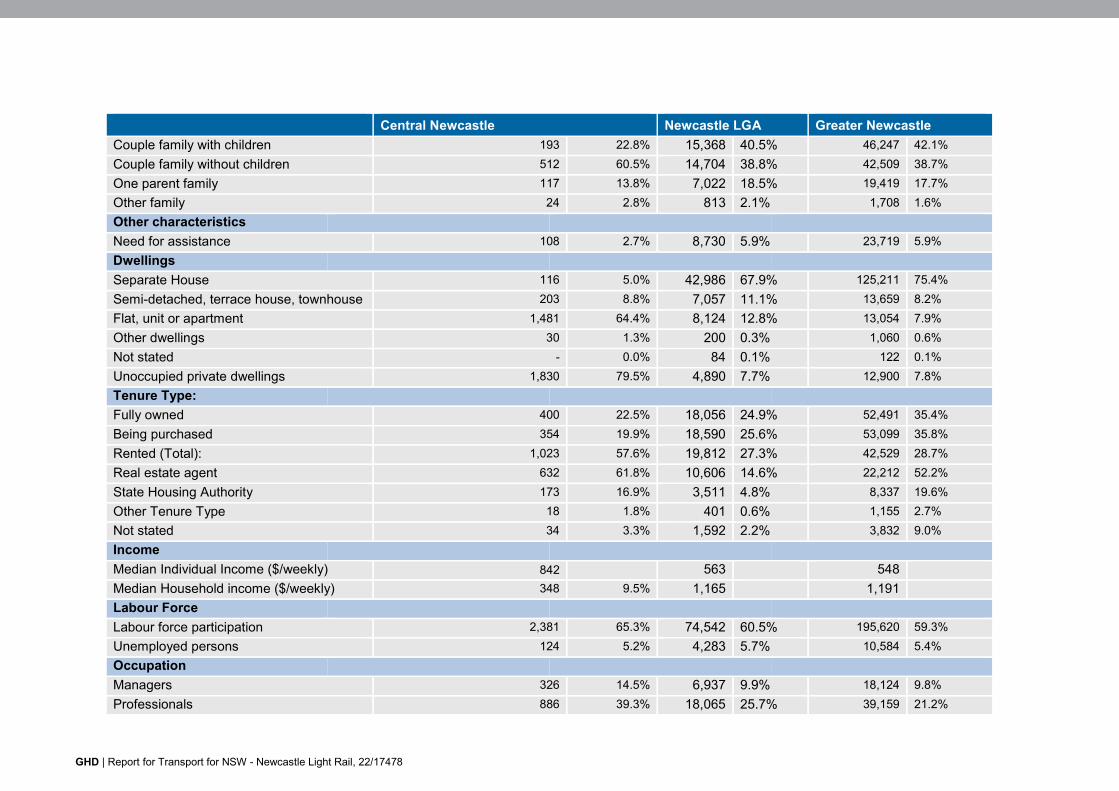
GHD | Report for Transport for NSW - Newcastle Light Rail, 22/17478
Central Newcastle Newcastle LGA Greater Newcastle Couple family with children 193 22.8% 15,368 40.5% 46,247 42.1% Couple family without children 512 60.5% 14,704 38.8% 42,509 38.7% One parent family 117 13.8% 7,022 18.5% 19,419 17.7% Other family 24 2.8% 813 2.1% 1,708 1.6% Other characteristics Need for assistance 108 2.7% 8,730 5.9% 23,719 5.9% Dwellings Separate House 116 5.0% 42,986 67.9% 125,211 75.4% Semi-detached, terrace house, townhouse 203 8.8% 7,057 11.1% 13,659 8.2% Flat, unit or apartment 1,481 64.4% 8,124 12.8% 13,054 7.9% Other dwellings 30 1.3% 200 0.3% 1,060 0.6% Not stated - 0.0% 84 0.1% 122 0.1% Unoccupied private dwellings 1,830 79.5% 4,890 7.7% 12,900 7.8% Tenure Type: Fully owned 400 22.5% 18,056 24.9% 52,491 35.4% Being purchased 354 19.9% 18,590 25.6% 53,099 35.8% Rented (Total): 1,023 57.6% 19,812 27.3% 42,529 28.7% Real estate agent 632 61.8% 10,606 14.6% 22,212 52.2% State Housing Authority 173 16.9% 3,511 4.8% 8,337 19.6% Other Tenure Type 18 1.8% 401 0.6% 1,155 2.7% Not stated 34 3.3% 1,592 2.2% 3,832 9.0% Income Median Individual Income ($/weekly) 842 563 548 Median Household income ($/weekly) 348 9.5% 1,165 1,191 Labour Force Labour force participation 2,381 65.3% 74,542 60.5% 195,620 59.3% Unemployed persons 124 5.2% 4,283 5.7% 10,584 5.4% Occupation Managers 326 14.5% 6,937 9.9% 18,124 9.8% Professionals 886 39.3% 18,065 25.7% 39,159 21.2%
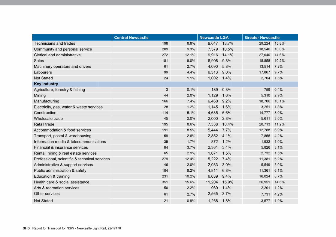
GHD | Report for Transport for NSW - Newcastle Light Rail, 22/17478
Central Newcastle Newcastle LGA Greater Newcastle Technicians and trades 198 8.8% 9,647 13.7% 29,224 15.8% Community and personal service 209 9.3% 7,379 10.5% 18,546 10.0% Clerical and administrative 272 12.1% 9,916 14.1% 27,040 14.6% Sales 181 8.0% 6,908 9.8% 18,858 10.2% Machinery operators and drivers 61 2.7% 4,090 5.8% 13,514 7.3% Labourers 99 4.4% 6,313 9.0% 17,867 9.7% Not Stated 24 1.1% 1,002 1.4% 2,704 1.5% Key Industry Agriculture, forestry & fishing 3 0.1% 189 0.3% 759 0.4% Mining 44 2.0% 1,129 1.6% 5,310 2.9% Manufacturing 166 7.4% 6,460 9.2% 18,706 10.1% Electricity, gas, water & waste services 28 1.2% 1,145 1.6% 3,251 1.8% Construction 114 5.1% 4,635 6.6% 14,777 8.0% Wholesale trade 45 2.0% 2,000 2.8% 5,611 3.0% Retail trade 195 8.6% 7,338 10.4% 20,713 11.2% Accommodation & food services 191 8.5% 5,444 7.7% 12,788 6.9% Transport, postal & warehousing 59 2.6% 2,852 4.1% 7,856 4.2% Information media & telecommunications 39 1.7% 872 1.2% 1,932 1.0% Financial & insurance services 84 3.7% 2,361 3.4% 5,826 3.1% Rental, hiring & real estate services 65 2.9% 1,071 1.5% 2,732 1.5% Professional, scientific & technical services 279 12.4% 5,222 7.4% 11,381 6.2% Administrative & support services 46 2.0% 2,083 3.0% 5,549 3.0% Public administration & safety 184 8.2% 4,811 6.8% 11,361 6.1% Education & training 231 10.2% 6,639 9.4% 16,024 8.7% Health care & social assistance 351 15.6% 11,204 15.9% 26,951 14.6% Arts & recreation services 50 2.2% 969 1.4% 2,201 1.2% Other services 61 2.7% 2,565 3.7% 7,731 4.2% Not Stated 21 0.9% 1,268 1.8% 3,577 1.9%
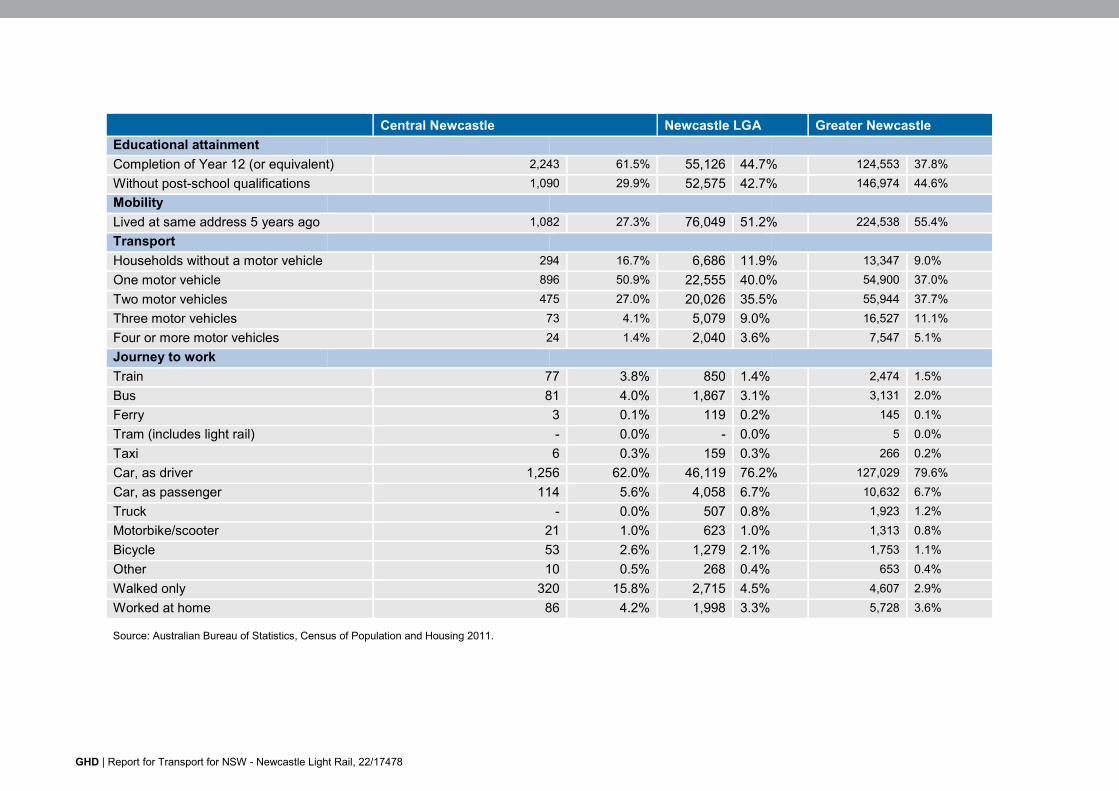
GHD | Report for Transport for NSW - Newcastle Light Rail, 22/17478
Central Newcastle Newcastle LGA Greater Newcastle Educational attainment Completion of Year 12 (or equivalent) 2,243 61.5% 55,126 44.7% 124,553 37.8% Without post-school qualifications 1,090 29.9% 52,575 42.7% 146,974 44.6% Mobility Lived at same address 5 years ago 1,082 27.3% 76,049 51.2% 224,538 55.4% Transport Households without a motor vehicle 294 16.7% 6,686 11.9% 13,347 9.0% One motor vehicle 896 50.9% 22,555 40.0% 54,900 37.0% Two motor vehicles 475 27.0% 20,026 35.5% 55,944 37.7% Three motor vehicles 73 4.1% 5,079 9.0% 16,527 11.1% Four or more motor vehicles 24 1.4% 2,040 3.6% 7,547 5.1% Journey to work Train 77 3.8% 850 1.4% 2,474 1.5% Bus 81 4.0% 1,867 3.1% 3,131 2.0% Ferry 3 0.1% 119 0.2% 145 0.1% Tram (includes light rail) - 0.0% - 0.0% 5 0.0% Taxi 6 0.3% 159 0.3% 266 0.2% Car, as driver 1,256 62.0% 46,119 76.2% 127,029 79.6% Car, as passenger 114 5.6% 4,058 6.7% 10,632 6.7% Truck - 0.0% 507 0.8% 1,923 1.2% Motorbike/scooter 21 1.0% 623 1.0% 1,313 0.8% Bicycle 53 2.6% 1,279 2.1% 1,753 1.1% Other 10 0.5% 268 0.4% 653 0.4% Walked only 320 15.8% 2,715 4.5% 4,607 2.9% Worked at home 86 4.2% 1,998 3.3% 5,728 3.6%
Source: Australian Bureau of Statistics, Census of Population and Housing 2011.
GHD | Report for Transport for NSW - Newcastle Light Rail, 22/17478
Appendix C – Social Infrastructure in or adjacent to the study area
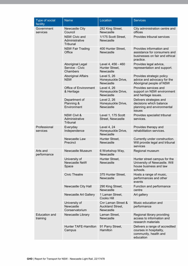
GHD | Report for Transport for NSW - Newcastle Light Rail, 22/17478
Type of social facility
Name Location Services
Government services
Newcastle City Council
282 King Street, Newcastle
City administration centre and offices
NSW Civic and Administrative Tribunal
1/175 Scott Street, Newcastle
Provides tribunal services
NSW Fair Trading Office
400 Hunter Street, Newcastle
Provides information and assistance for consumers and businesses on fair and ethical practice.
Aboriginal Legal Service - Civic Chambers
Level 4, 456 - 460 Hunter Street, Newcastle
Provides legal advice, representation and support.
Aboriginal Affairs NSW
Level 5, 26 Honeysuckle Drive, Newcastle
Provides strategic policy advice and advocacy for the Aboriginal people of NSW
Office of Environment & Heritage
Level 4, 26 Honeysuckle Drive, Newcastle
Provides services and support on NSW environment and heritage issues.
Department of Planning & Environment
Level 2, 26 Honeysuckle Drive, Newcastle
Delivers strategies and decisions which balance planning and environmental issues
NSW Civil & Administrative Tribunal
Level 1, 175 Scott Street, Newcastle
Provides specialist tribunal services.
Professional services
Everyday Independence
Level 4, 24 Honeysuckle Drive, Newcastle
Provides therapy and rehabilitation services.
Newcastle Law Precinct
Hunter Street, Newcastle
Currently under construction. Will provide legal and tribunal services
Arts and performance
Newcastle Museum 6 Workshop Way, Newcastle
Regional museum
University of Newcastle NeW Space
Hunter Street, Newcastle
Hunter street campus for the University of Newcastle. Will house business and law schools.
Civic Theatre 375 Hunter Street, Newcastle
Hosts a range of music, performances and other events
Newcastle City Hall 290 King Street, Newcastle
Function and performance centre
Newcastle Art Gallery 1 Laman Street, Cooks Hill
Art gallery
University of Newcastle Conservatorium
Cnr Laman Street & Auckland Street, Newcastle
Music education and performance
Education and training
Newcastle Library Laman Street, Newcastle
Regional library providing access to information and research materials
Hunter TAFE-Hamilton Campus
91 Parry Street, Hamilton
Delivers a range of accredited courses in hospitality, community, health and education
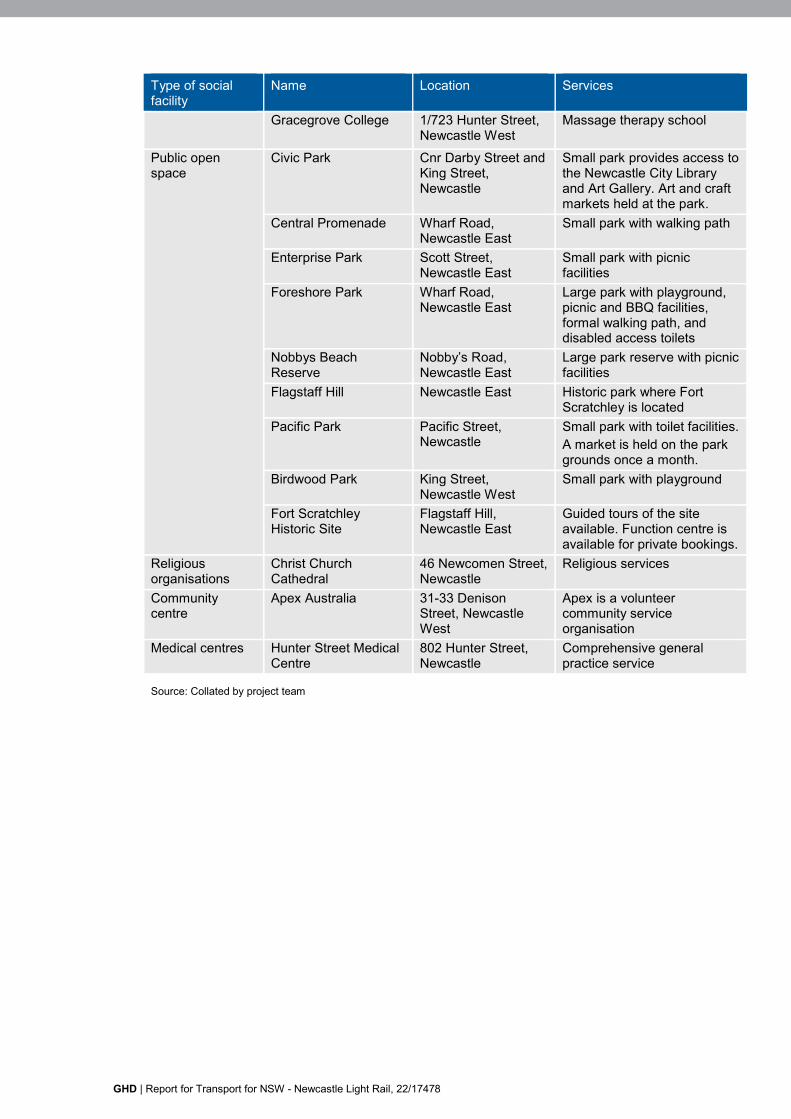
GHD | Report for Transport for NSW - Newcastle Light Rail, 22/17478
Type of social facility
Name Location Services
Gracegrove College 1/723 Hunter Street, Newcastle West
Massage therapy school
Public open space
Civic Park Cnr Darby Street and King Street, Newcastle
Small park provides access to the Newcastle City Library and Art Gallery. Art and craft markets held at the park.
Central Promenade Wharf Road, Newcastle East
Small park with walking path
Enterprise Park Scott Street, Newcastle East
Small park with picnic facilities
Foreshore Park Wharf Road, Newcastle East
Large park with playground, picnic and BBQ facilities, formal walking path, and disabled access toilets
Nobbys Beach Reserve
Nobby’s Road, Newcastle East
Large park reserve with picnic facilities
Flagstaff Hill Newcastle East Historic park where Fort Scratchley is located
Pacific Park Pacific Street, Newcastle
Small park with toilet facilities. A market is held on the park grounds once a month.
Birdwood Park King Street, Newcastle West
Small park with playground
Fort Scratchley Historic Site
Flagstaff Hill, Newcastle East
Guided tours of the site available. Function centre is available for private bookings.
Religious organisations
Christ Church Cathedral
46 Newcomen Street, Newcastle
Religious services
Community centre
Apex Australia 31-33 Denison Street, Newcastle West
Apex is a volunteer community service organisation
Medical centres Hunter Street Medical Centre
802 Hunter Street, Newcastle
Comprehensive general practice service
Source: Collated by project team
GHD
Level 3 GHD Tower 24 Honeysuckle Drive Newcastle NSW 2300 PO Box 5403 Hunter Region Mail Centre NSW 2310 T: (02) 4979 9999 F: (02) 4979 9988 E: [email protected]
© GHD 2015
This document is and shall remain the property of GHD. The document may only be used for the purpose for which it was commissioned and in accordance with the Terms of Engagement for the commission. Unauthorised use of this document in any form whatsoever is prohibited. N:\AU\Newcastle\Projects\22\17478\WP\109030.docx
Document Status
Rev No.
Author Reviewer Approved for Issue
Name Signature Name Signature Date 0 A Mithieux L King
L Harding L King G Marshall G Marshall 07/03/2016
1 A Mithieux L King L Harding
G Marshall 30/03/2016

www.ghd.com