Embed Size (px)
Citation preview

NEW ZEALAND TRANSPORT AGENCY
SH20 MT ROSKILL EXTENSION
Erosion and Sediment Control
Comparison with NZTA Draft Erosion & Sediment
Control Standard Requirements

NEW ZEALAND TRANSPORT AGENCY
SH20 Mt Roskill Extension
Erosion and Sediment Control
Comparison with NZTA Draft Erosion & Sediment Control
Standard Requirements
Prepared By Opus International Consultants Limited
Zeb Worth Environmental
Environmental Engineer Level 3, The Westhaven
100 Beaumont Street, PO Box 5848
Auckland, New Zealand
Reviewed By
Warren Bird
Team Leader – Water Resources
Telephone: +64 9 355 9500
Facsimile: +64 9 355 9584
Approved By Date: 11 February 2011
Matt Thompson Reference: 1-T0063.00/00AE
Status: FINAL
© Opus International Consultants Limited 2008 o:\env\transport\nzta\proj\1-t0063.00 - nzta erosion and sediment control standard road test\600 deliverables\610 reports\sh20\sh20 mt
roskill extension - nzta escs road test_final 20110207.docx

SH20 Mt Roskill Extension
Erosion and Sediment Control
Comparison with NZTA Draft Erosion & Sediment Control Standard Requirements
1-T0063.00/00AE
February 2011 FINAL i
Executive Summary
The purpose of this study is to provide a comparison between the designed/constructed Erosion
and Sediment Control measures employed on the SH20 Mt Roskill Extension project and the
anticipated design requirements and outcomes under the Draft Erosion and Sediment Control
Standard for State Highway Infrastructure (August 2010). The study is also intended to provide a
high level assessment of the Draft NZTA Standard and the implications of adopting this standard
for the design of Erosion and Sediment Control measures on state highway projects nationwide.
The SH20 Mt Roskill Extension project itself consisted of the construction of a 4km length of 4-lane
motorway including two full diamond interchanges. The project also featured two dedicated bus
shoulder lanes and provision for a future rail line. The majority of the project site drains to the
upper reaches of the Oakley Creek. The southern limit of the project drains toward Onehunga
Bay. Due to the sensitivity of both the Oakley Creek and Onehunga Bay to sediment discharges,
rain activated chemical treatment systems for sediment retention ponds on the project were
required as a condition of the Auckland Regional Council Land Use (earthworks) Consents.
The adoption of the Draft NZTA Standard would not have fundamentally altered the consenting
requirements or design objectives relating to Erosion and Sediment Control on the project.
However, a number of aspects would have led to some variation in the scope of some of the
sediment control measures and the construction, operation, monitoring and maintenance of these
devices, namely;
• The adoption of a risk based approach for selection of the design storm event is considered to
be a more appropriate method for determining the design runoff flows/volumes as it takes into
account the specific characteristics of the site and receiving environment. However, this would
have led to an increase of approximately 32% in the required storage volumes for all storage
based practices (i.e. ponds and decanting earth bunds) with an increase of approximately 16%
in ponds construction costs and associated time implications.
• The inclusion of minimum water quality monitoring requirements, would have increased the
cost and man-hour requirements for monitoring and testing. However, the data collected from
this monitoring over time will assist in refining the design and operation of Erosion and
Sediment Control measures
• The increase in maintenance frequency of some devices (e.g. silt fences) due to reduced
allowable sediment accumulation would have led to higher operating costs.
The inclusion of the Erosion and Sediment Control Field Guide for Contractors provides extended
guidance (over and above that provided in ARC TP90) for the construction, maintenance and
decommissioning of practices in a concise, user-friendly format. It is expected that this will greatly
improve contractors’ understanding of erosion and sediment control concepts and potentially lead
to improved maintenance regimes and reduced cost/time for preparation of contractors’
environmental management plans
Overall the Draft NZTA Standard would have equalled or exceeded the Auckland regional
requirements for Erosion and Sediment Control on the project and represents an incremental
improvement over current regional guidelines. Ultimately it is considered that, while it would likely
have led to some increase in Erosion and Sediment Control costs on the SH20 Mt Roskill
Extension project, the adoption of the standard nationally would improve the design, operation and
maintenance of control measures and generally reduce the environmental impact of state highway
projects in relation to construction erosion and sediment.

SH20 Mt Roskill Extension
Erosion and Sediment Control
Comparison with NZTA Draft Erosion & Sediment Control Standard Requirements
1-T0063.00/00AE
February 2011 FINAL ii
Contents
1 Project Description .............................................................................................................. 1
1.1 Project Location ............................................................................................................ 1
1.2 Delivery Method ............................................................................................................ 1
1.3 Project Scope ............................................................................................................... 2
1.4 Site Constraints ............................................................................................................ 2
1.5 Natural Site Features .................................................................................................... 3
2 Environmental Factors ........................................................................................................ 4
3 Designed Solutions ............................................................................................................. 7
3.1 Design Philosophy ........................................................................................................ 7
3.2 Project Requirements ................................................................................................. 10
3.3 Erosion and Sediment Control Practices ..................................................................... 14
3.4 Cost ............................................................................................................................ 17
3.5 Time ........................................................................................................................... 20
4 General Comments ............................................................................................................ 22
4.1 Design/Construction Issues ........................................................................................ 22
4.2 Project Completion ..................................................................................................... 22
4.3 Anticipated Effects of Applying Draft NZTA Standard.................................................. 22
4.4 General Comments ..................................................................................................... 23
Tables
Table 1: Environmental Factors on SH20 Mt Roskill Extension Project
Table 2: Sediment Retention Pond Summary Design Parameters
Table 3: Sediment Retention Pond Design Comparison
Appendices
Appendix A: Design Erosion and Sediment Control Plans
Appendix B: Design Information
SH20 Mt Roskill Extension
Erosion and Sediment Control
Comparison with NZTA Draft Erosion & Sediment Control Standard Requirements
1-T0063.00/00AE
February 2011 FINAL 1
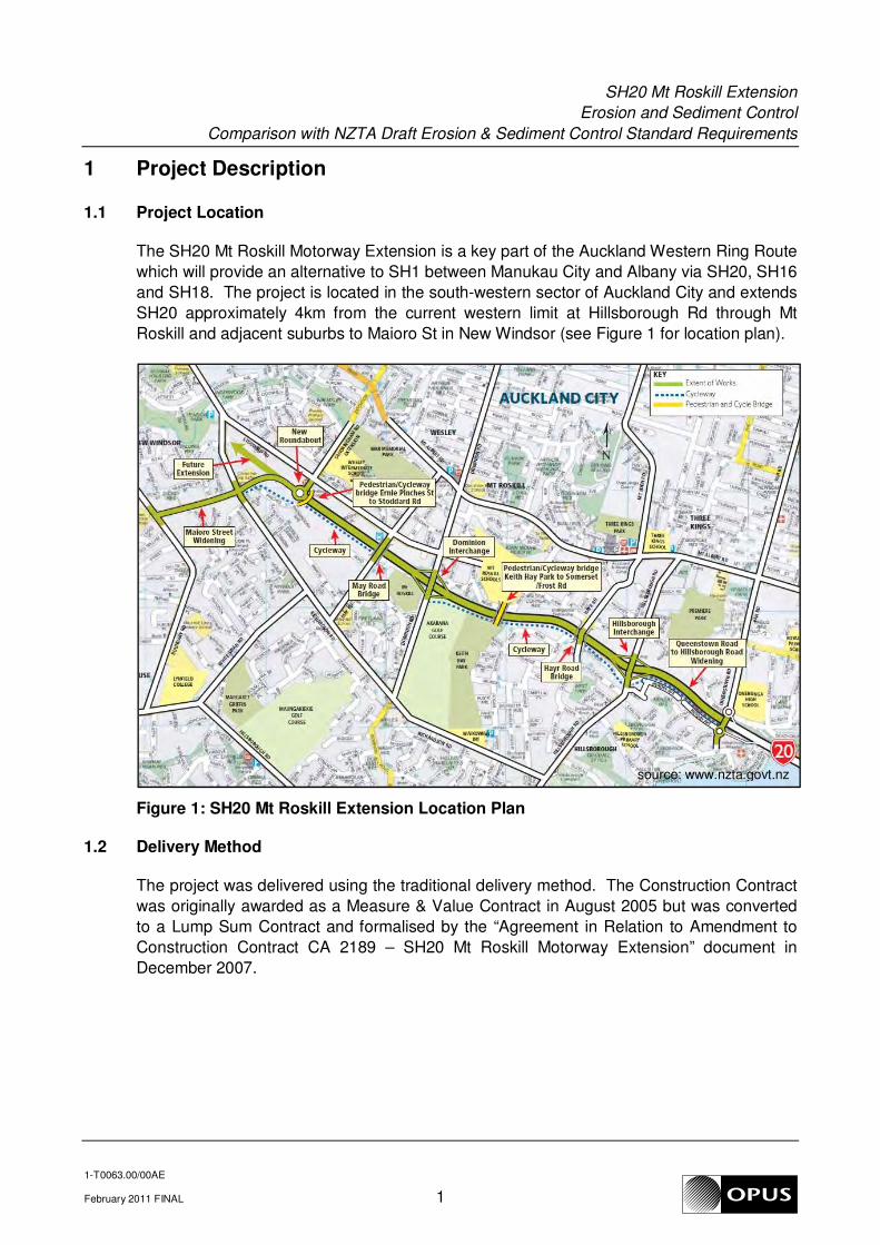
1 Project Description
1.1 Project Location
The SH20 Mt Roskill Motorway Extension is a key part of the Auckland Western Ring Route
which will provide an alternative to SH1 between Manukau City and Albany via SH20, SH16
and SH18. The project is located in the south-western sector of Auckland City and extends
SH20 approximately 4km from the current western limit at Hillsborough Rd through Mt
Roskill and adjacent suburbs to Maioro St in New Windsor (see Figure 1 for location plan).
Figure 1: SH20 Mt Roskill Extension Location Plan
1.2 Delivery Method
The project was delivered using the traditional delivery method. The Construction Contract
was originally awarded as a Measure & Value Contract in August 2005 but was converted
to a Lump Sum Contract and formalised by the “Agreement in Relation to Amendment to
Construction Contract CA 2189 – SH20 Mt Roskill Motorway Extension” document in
December 2007.
source: www.nzta.govt.nz

SH20 Mt Roskill Extension
Erosion and Sediment Control
Comparison with NZTA Draft Erosion & Sediment Control Standard Requirements
1-T0063.00/00AE
February 2011 FINAL 2
1.3 Project Scope
The project involved the construction of a 4km length of 4-lane motorway including two full
diamond interchanges at Hillsborough Rd and Dominion Rd. Works at the southern tie-in
with the existing SH20 involved widening and realigning the carriageway between the
Queenstown Rd ramps and the Hillsborough Rd interchange. The north-western end of the
route involved a new roundabout at the intersection with Sandringham Rd and widening of
the Maioro St carriageway to four lanes from the Sandringham Rd roundabout to the
Richardson Rd intersection. The project featured two dedicated bus shoulder lanes and
provision for a future rail line.
Four road bridges were constructed as part of the project; one at each of the two
interchanges and local road overpasses at May Rd and Hayr Rd. Two cable-stay
pedestrian and cycle bridges were constructed over the route at Keith Hay Park and Ernie
Pinches St to provide linkages between the residential areas to the south of the route and
the commercial/industrial areas and schools to the north. Significant retaining walls were
constructed along the route, particularly toward the southern end and at the Dominion Rd
interchange to minimise the total width of the route and allow for provision of the rail
corridor.
1.4 Site Constraints
The project was constructed in a relatively narrow designation corridor. This led to the use
of extensive retaining walls and in some cases reduced shoulder widths along the route.
This also meant that in several areas, the works came in close proximity to residential
houses, presenting noise, vibration and dust issues. To minimise disruption, working hours
had to be restricted and weekend work limited, placing constraints on the project program.
Due to the project location it crossed all of the major arterial roads leading from the
Hillsborough and Mt Roskill south residential areas. This presented challenges in terms of
maintaining access to and from these residential zones. Continuous access needed to be
provided for both during construction and in the permanent designed solution.
Three separate contaminated sites were identified along the designation. A consent to
discharge excavated contaminated soil to land was required by the ARC. Soil testing was
undertaken and a Contaminated Site Management Plan prepared, detailing the procedures
to be undertaken in the event of possible contamination being uncovered.

SH20 Mt Roskill Extension
Erosion and Sediment Control
Comparison with NZTA Draft Erosion & Sediment Control Standard Requirements
1-T0063.00/00AE
February 2011 FINAL 3
1.5 Natural Site Features
1.5.1 Oakley Creek
The majority of the project site drains westward toward the Waterview estuary via
Oakley Creek. While the upper reaches of the Oakley Creek (in the immediate
vicinity of the project) are generally heavily modified engineered channels and
culverts, the lower reaches contain relatively high value fresh water habitats
(including the last remaining natural waterfall within the Auckland City metropolitan
limits). Sediment discharges into this environment could have significant adverse
effects on both stream ecology and geomorphology. Accordingly, emphasis was
placed on erosion and sediment control for all works in and around this watercourse
and stormwater systems draining to it.
1.5.2 Onehunga Lagoon
The southern limit of the project drains toward Onehunga Bay/Lagoon. Due to the
highly depositional nature of this environment, sediment discharges can have a
significant impact on the marine habitat value of the lagoon. To minimise the risk of
uncontrolled sediment discharges to the Onehunga Lagoon, robust erosion and
sediment controls were required for all works in and around this area.
Due to the sensitivity of both the Oakley Creek and Onehunga Lagoon to sediment
discharges, rain activated chemical treatment systems for sediment retention ponds
on the project were required as a condition of the Auckland Regional Council Land
Use (earthworks) Consents
1.5.3 Mt Roskill volcanic cone
The area around the base of the Mount Roskill Volcanic Cone potentially contained
significant geological and cultural features. Works in this area required pre
construction briefing sessions to determine what features might be present and how
to identify such features. Earthworks in the immediate vicinity of the Mt Roskill
Volcanic Cone also required the presence of qualified archaeologists and geologists
to identify and manage any significant finds.
Specific guidance and protocols were established for management of any significant
archaeological or geologic artefacts. These protocols were documented in the site
Environmental Management Plan.
SH20 Mt Roskill Extension
Erosion and Sediment Control
Comparison with NZTA Draft Erosion & Sediment Control Standard Requirements
1-T0063.00/00AE
February 2011 FINAL 4
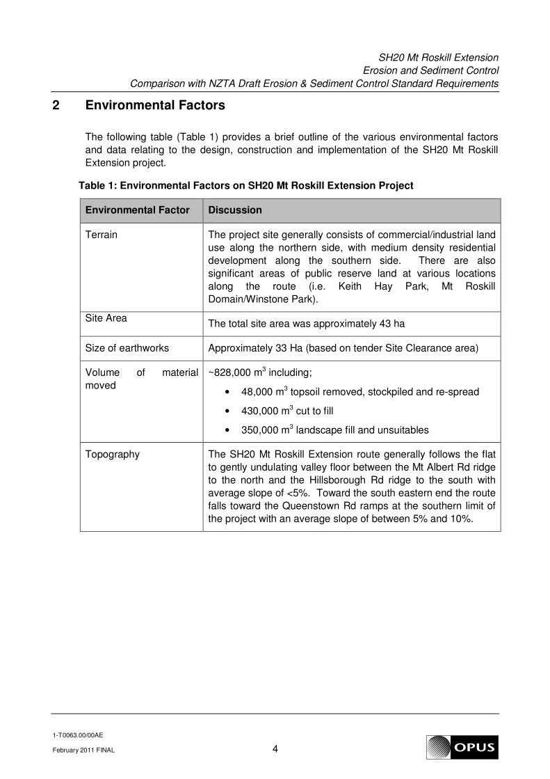
2 Environmental Factors
The following table (Table 1) provides a brief outline of the various environmental factors
and data relating to the design, construction and implementation of the SH20 Mt Roskill
Extension project.
Table 1: Environmental Factors on SH20 Mt Roskill Extension Project
Environmental Factor Discussion
Terrain The project site generally consists of commercial/industrial land
use along the northern side, with medium density residential
development along the southern side. There are also
significant areas of public reserve land at various locations
along the route (i.e. Keith Hay Park, Mt Roskill
Domain/Winstone Park).
Site Area The total site area was approximately 43 ha
Size of earthworks Approximately 33 Ha (based on tender Site Clearance area)
Volume of material
moved
~828,000 m3 including;
• 48,000 m3 topsoil removed, stockpiled and re-spread
• 430,000 m3 cut to fill
• 350,000 m3 landscape fill and unsuitables
Topography The SH20 Mt Roskill Extension route generally follows the flat
to gently undulating valley floor between the Mt Albert Rd ridge
to the north and the Hillsborough Rd ridge to the south with
average slope of <5%. Toward the south eastern end the route
falls toward the Queenstown Rd ramps at the southern limit of
the project with an average slope of between 5% and 10%.
SH20 Mt Roskill Extension
Erosion and Sediment Control
Comparison with NZTA Draft Erosion & Sediment Control Standard Requirements
1-T0063.00/00AE
February 2011 FINAL 5
Environmental Factor Discussion
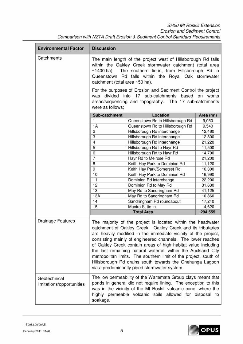
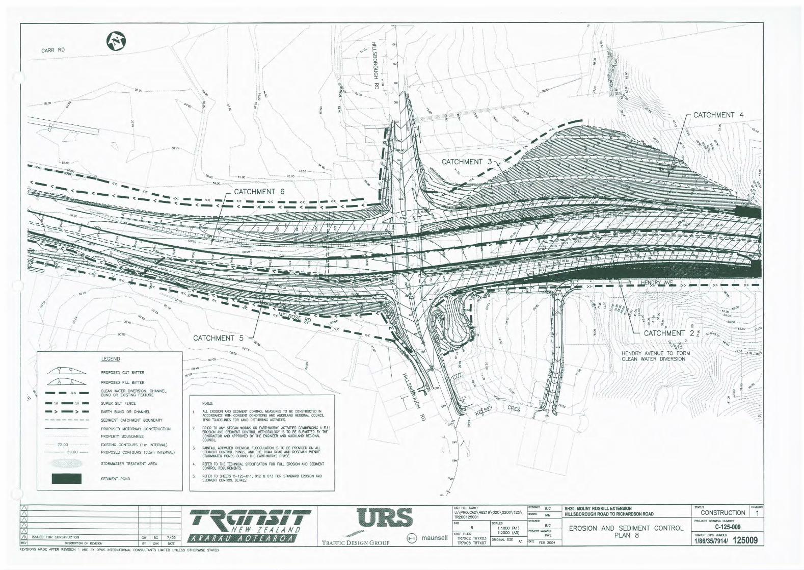
Catchments The main length of the project west of Hillsborough Rd falls
within the Oakley Creek stormwater catchment (total area
~1400 ha). The southern tie-in, from Hillsborough Rd to
Queenstown Rd falls within the Royal Oak stormwater
catchment (total area ~50 ha).
For the purposes of Erosion and Sediment Control the project
was divided into 17 sub-catchments based on works
areas/sequencing and topography. The 17 sub-catchments
were as follows;
Sub-catchment Location Area (m2)
1 Queenstown Rd to Hillsborough Rd 9,050
1A Queenstown Rd to Hillsborough Rd 9,540
2 Hillsborough Rd interchange 12,460
3 Hillsborough Rd interchange 12,800
4 Hillsborough Rd interchange 21,220
5 Hillsborough Rd to Hayr Rd 11,500
6 Hillsborough Rd to Hayr Rd 14,700
7 Hayr Rd to Melrose Rd 21,200
8 Keith Hay Park to Dominion Rd 11,120
9 Keith Hay Park/Somerset Rd 16,300
10 Keith Hay Park to Dominion Rd 16,990
11 Dominion Rd interchange 22,200
12 Dominion Rd to May Rd 31,630
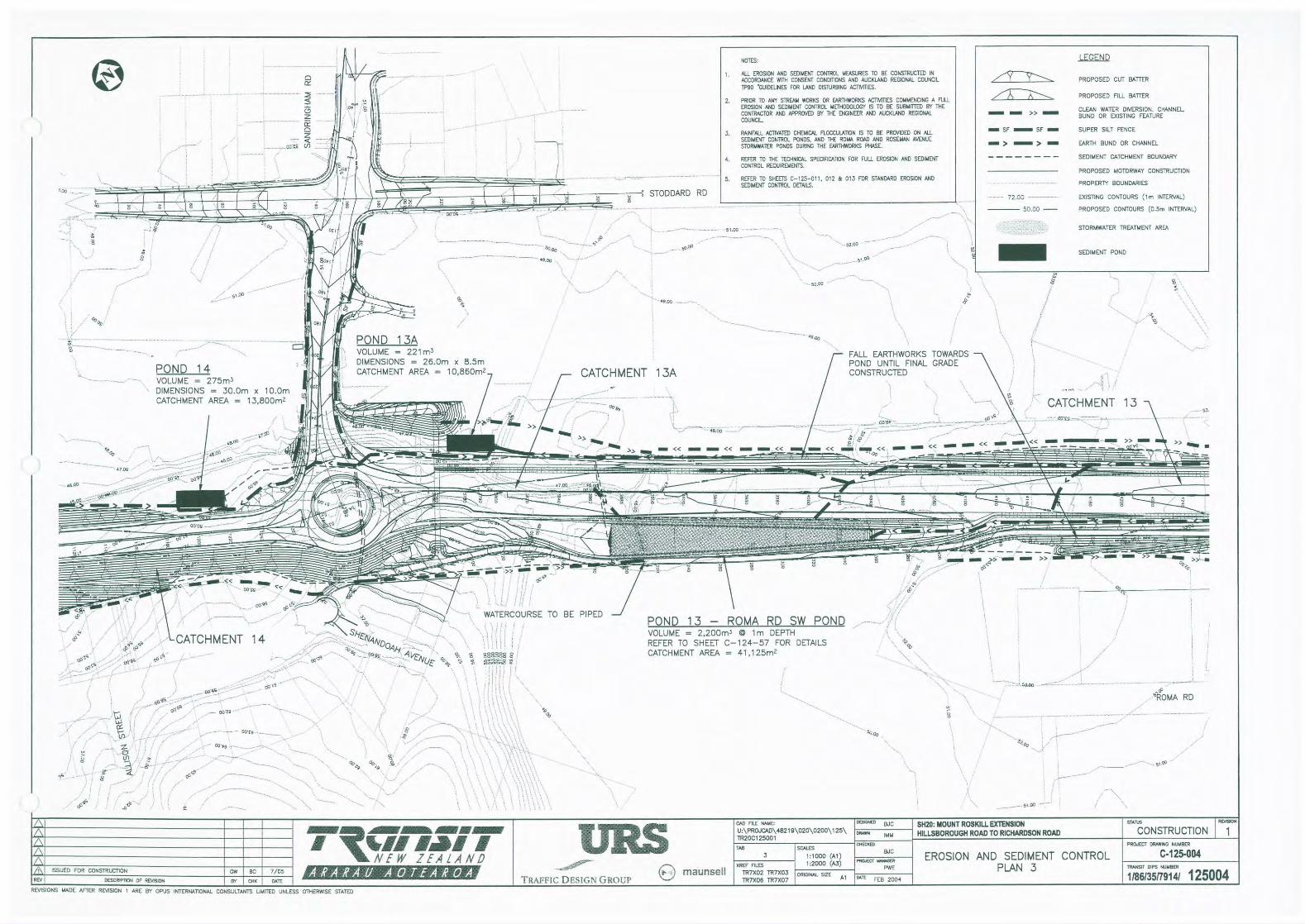
13 May Rd to Sandringham Rd 41,125
13A May Rd to Sandringham Rd 10,860
14 Sandringham Rd roundabout 17,240
15 Maoiro St tie-in 14,620
Total Area 294,555
Drainage Features The majority of the project is located within the headwater
catchment of Oakley Creek. Oakley Creek and its tributaries
are heavily modified in the immediate vicinity of the project,
consisting mainly of engineered channels. The lower reaches
of Oakley Creek contain areas of high habitat value including
the last remaining natural waterfall within the Auckland City
metropolitan limits. The southern limit of the project, south of
Hillsborough Rd drains south towards the Onehunga Lagoon
via a predominantly piped stormwater system.
Geotechnical
limitations/opportunities
The low permeability of the Waitemata Group clays meant that
ponds in general did not require lining. The exception to this
was in the vicinity of the Mt Roskill volcanic cone, where the
highly permeable volcanic soils allowed for disposal to
soakage.

SH20 Mt Roskill Extension
Erosion and Sediment Control
Comparison with NZTA Draft Erosion & Sediment Control Standard Requirements
1-T0063.00/00AE
February 2011 FINAL 6
Environmental Factor Discussion
Soils The soil profile along the route generally consists of weathered
Miocene Waitemata Group materials overlain by Holocene and
Pleistocene Tauranga Group alluvium and peat deposits
(ranging from silty clays to silty sands). In the vicinity of the Mt
Roskill volcanic cone the Waitemata Group rocks are overlain
by layers of volcanic tuff ash, scoria and basalt flows.
Erosion potential The weathered Waitemata Group soils found along the route
are highly susceptible to erosion. However, due to the
relatively low site slopes and associated low runoff velocities
the actual erosion potential on the project was generally low.
Site flooding history Keith Hay Park is located within the floodplain of the upper
reaches of Oakley Creek. During significant rainfall events the
park serves a detention function by providing storage for runoff
that would otherwise continue on to the lower reaches of the
creek.
Design storm event The designed erosion & sediment control systems were based
on Auckland Regional Council’s “Technical Publication No. 90:
Erosion & Sediment Control Guidelines for Land Disturbing
Activities in the Auckland Region” (ARC TP90) criteria.
TP90 uses the 5% AEP 24hr rainfall event for sizing of devices
VKT at time of
completion
The estimated traffic volume along the route at the time of
completion was 46,000 - 69,000 vpd (depending on location).
Over the 4km length, this gives a total of 184,000 -
276,000 VKT/day.
Catchment
classification1
The project catchment can be classified as urban
Sensitivity of receiving
environments2
Attribute Sensitivity Score
Type Sensitivity Moderate 20
Ecological Value Moderate 10
Human Use Value Moderate 5
Overall Sensitivity Rating (Sum) Medium 35
Source: SH20 Mt Roskill Extension Stormwater Management Systems
Project Review and Summary (URS 2008)
1 Refer “National State Highway Strategy” (Transit NZ, 2007)
2 Refer “Identifying Sensitive Receiving Environments at Risk from Road Runoff” (LTNZ, 2007)

SH20 Mt Roskill Extension
Erosion and Sediment Control
Comparison with NZTA Draft Erosion & Sediment Control Standard Requirements
1-T0063.00/00AE
February 2011 FINAL 7
3 Designed Solutions
This section provides a comparison between the designed/constructed Erosion and Sediment
Control Measures on the SH20 Mt Roskill Extension project and the requirements under the Draft
NZTA Standard with respect to the following general aspects:
• Design philosophy;
• Project Requirements (e.g. consents, phasing etc.);
• Erosion and Sediment Control practices;
• Cost; and
• Time.
Each element has been divided into the designed/constructed outcome (Existing Design) and the
anticipated outcome under the Draft NZTA Standard
3.1 Design Philosophy
3.1.1 Objectives
Existing Design
Under the Auckland Regional Plan: Sediment (November 2001), the following objectives are stated
relating to earth disturbing activities;
7.1.1 To reduce the exposure of land to the risk of surface erosion leading to sediment
generation.
7.1.2 To minimise sediment discharge to the receiving environment
The methods used for Erosion and Sediment Control on the SH20 Mt Roskill Extension project were
generally in accordance with meeting these objectives and included the following principles;
• Minimising erosion by limiting the disturbed area and stabilising surfaces as soon as
practicable;
• Reducing off-site run-on by diverting clean water at the site perimeter preventing it from flowing
across disturbed areas and;
• Capturing sediment laden run-off and diverting it to treatment systems before discharge.
Draft NZTA Standard
It anticipated that the above objectives would still have been applicable if the Draft NZTA Standard
had been adopted for the project. However, in addition to regional requirements, the objectives
outlined in Section 2.4 of the NZTA Environmental Plan (2008) would also have applied, namely;
ES1 Ensure construction and maintenance activities avoid, remedy or mitigate effects of soil erosion, sediment run-off and sediment deposition.
ES2 Identify areas susceptible to erosion and sediment deposition and implement erosion and sediment control measures appropriate to each situation with particular emphasis on high- risk areas.
ES3 Use bio-engineering and low-impact design practices where practicable

SH20 Mt Roskill Extension
Erosion and Sediment Control
Comparison with NZTA Draft Erosion & Sediment Control Standard Requirements
1-T0063.00/00AE
February 2011 FINAL 8
3.1.2 Criteria
Existing Design
The basic design criteria used for Erosion and Sediment Control practices on the SH20 Mt Roskill
Extension project are those contained in ARC TP90. A summary of the applicable design criteria is
given below;
Sediment Retention Pond:
2% pond sizing used (for site slopes less than 10% and less than 200m in length) i.e. 200m3 per
hectare of catchment area. Maximum catchment area of 5.0 ha. Maximum depth of 2 m
Decanting Bunds:
Volume sizing as per ponds. Maximum 0.3 ha catchment area.
Diversion Channels:
Conveyance provided for the 5% AEP storm event (20yr ARI) with nominal 300mm freeboard.
Maximum longitudinal grade of 2% unless armoured.
Silt Fences:
Catchment size generally limited to 0.5 ha.
Draft NZTA Standard
The Draft NZTA Standard design criteria for the various erosion and sediment control measures
used on the SH20 Mt Roskill Extension project are almost identical to those given in the ARC TP90
document. The most notable exceptions to this are the selection of the design storm event and the
storage practice, i.e. pond and decanting earth bund sizing methodology (discussed further in
Section 3.3.2) and decant rate calculation.
Design Storm Selection:
The selection of the design storm under the Draft NZTA Standard is based on the risk based
approach given in the Australia New Zealand Environment and Conservation Council (ANZECC)
guidelines. Due to the characteristics of the Mt Roskill Extension project the design storm event
would be the 20-year 1-hour storm (essentially the same as that under ARC TP90). However,
depending on the nature and location of a project, the methodology for the selection of the design
storm event could lead to a different event being selected (as opposed to the blanket 5% AEP event
used for all projects under ARC TP90).
Storage Device Sizing:
The sizing criteria used by the Draft NZTA Standard is based on the design storm event and the
runoff characteristics of any given catchment using the Rational Formula to estimate runoff
volumes. This means that storage volumes are based on more project specific parameters than
those obtained using the sizing methodology in ARC TP90. On the Mt Roskill extension project this
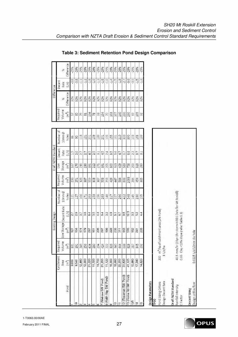
would have increased the required storage volumes by approximately 32%.
Decant Rate:
The decant rate calculation used in the Draft NZTA Standard is based on the total live storage
volume released over 24-hours (as opposed to 3 L/s/ha used in ARC TP90). On the Mt Roskill
Extension project this would have led to 29% reduction in decant rates from the various storage
devices. This would also have led to longer retention times and potentially greater sediment
removal efficiency.
SH20 Mt Roskill Extension
Erosion and Sediment Control
Comparison with NZTA Draft Erosion & Sediment Control Standard Requirements
1-T0063.00/00AE
February 2011 FINAL 9
3.1.3 References
Existing Design
References used for the design of the SH20 Mt Roskill Extension Erosion and Sediment Control
practices included the following;
• Auckland Regional Plan: Sediment (November 2001)
• Auckland Regional Council Technical Publication No.90 “Erosion and Sediment Control
Guidelines for Land Disturbing Activities in the Auckland Region” (March 1999)
Draft NZTA Standard
Under the Draft NZTA Standard, the reference documents used for the design and development of
the Erosion and Sediment Control measures would generally remain the same, with the addition of
the following documents;
• NZTA Environmental Plan
• NZTA Draft Erosion and Sediment Control Standard for State Highway Infrastructure
• Australia New Zealand Environment and Conservation Council (ANZECC) Guidelines for Fresh
and Marine Water Quality.
These documents would be used in conjunction with the relevant regional policies and guidelines to
establish the more stringent requirements and objectives for erosion and sediment control. The
more stringent guidelines would be followed.
In the case of the SH20 Mt Roskill Extension project, the Draft NZTA guidelines would take
precedence as they provide more stringent criteria for design and sizing of storage devices and at
least equal criteria for all other erosion and sediment control practices used on the project.
The NZTA Environmental Plan is complimentary to the Auckland Regional Plan: Sediment and the
design objectives in both documents would have applied to the project.
The ANZECC guidelines would serve as a reference for risk assessment of the receiving
environment as the methodology used in the Draft NZTA Standard is based on these guidelines.

SH20 Mt Roskill Extension
Erosion and Sediment Control
Comparison with NZTA Draft Erosion & Sediment Control Standard Requirements
1-T0063.00/00AE
February 2011 FINAL 10
3.2 Project Requirements
3.2.1 Local Consent Requirements
Existing Design
A Land Use Earthworks Consent is required from the Auckland Regional Council under the
Auckland Regional Plan: Sediment Control for all earthworks activities > 1.0 ha for land slopes less
than 15o or > 0.25 ha for sites with slopes greater than 15
o outside the Sediment Control Protection
Area1. For sites within the Sediment Control Protection Area any earthworks greater than 0.25 ha in
area require a consent.
Accordingly the earthworks for the SH20 Mt Roskill Extension project required resource consent
from the Auckland Regional Council. The consents with specific conditions relating to erosion and
sediment control were;
ARC 26044 – Sediment control within the Royal Oak catchment (superseded by ARC 31074)
ARC 26047 – Sediment control within the Oakley catchment (superseded by ARC 31076)
ARC 26048 – Works in a watercourse within Oakley catchment (superseded by ARC 31077)
ARC 31074 – Earthworks within Royal Oak catchment
ARC 31076 – Earthworks within Oakley Creek catchment
ARC 31077 – Works in Watercourse within Oakley Creek catchment
The conditions of the above consents required all Erosion and Sediment Control measures to be
constructed and maintained in accordance with ARC TP90. Further, as a requirement of the
Environment Court decision on the project, all sediment retention ponds were required to be
flocculated using rainfall activated flocculent dosing systems.
Other consents with reference to Erosion and Sediment Control were required from Auckland City
Council for associated minor works outside of the main motorway site designation. These included;
Earthworks and Tree Removal consent for Keith Hay Park (ACC AO/02/04104) and; Earthworks for
Re-grading of Winstone Park Access Road (ACC AO/02/05661). The general requirement of these
Auckland City Council consents in relation to Erosion and Sediment Control was to provide
appropriate measures to prevent discharge of sediment off-site.
Draft NZTA Standard
Adoption of the Draft NZTA standard would not have change the regulatory environment in which
the project occurred.
As such, the required resource consents and associated consent conditions would not have altered
significantly, except for perhaps a consent condition that all practices must be designed and
constructed in accordance with the Draft NZTA Standard, rather than ARC TP90.
1 The Sediment Control protection Area is defined as 100m either side of a foredune or 100m landward of
the costal marine area (whatever is the more landward of mean high water springs); or 50m landward of the
edge of a watercourse or wetland of 1000 m2 or more.

SH20 Mt Roskill Extension
Erosion and Sediment Control
Comparison with NZTA Draft Erosion & Sediment Control Standard Requirements
1-T0063.00/00AE
February 2011 FINAL 11
3.2.2 Phasing
Existing Design
Earthworks were phased in some areas such as the Keith Hay Park/Oakley Creek crossing to
provide pre-loading of embankments over soft (alluvium/peat) soils to minimise long term settlement
effects on the motorway carriageway.
In general, earthworks were staged along the route to ensure that the bare earth area open at any
given time was within the limits given in the relevant resource consents. Areas not being worked
were temporarily or permanently stabilised to reduce erosion and sediment generation from these
areas (see Sections 3.2.3 and 3.3.1 for further details of stabilisation techniques used).
Draft NZTA Standard
While some discussion on construction sequencing and staging is given in the Draft NZTA Standard
(in particular Sections 4.6 and 7.2.3), no direct requirements are given. Under the Draft NZTA
Standard, the requirements for staging of works and maximum exposed areas would have been left
to the discretion of the consenting authority, as was the case on the SH20 Mt Roskill Extension
project via way of consent conditions.
3.2.3 Winter Construction
Existing Design
Some earthworks excavation was undertaken during the two winter periods over approx 1 km of the
site in the volcanic area. A specific Erosion and Sediment Control Plan was prepared which
sequenced excavation of limited cut areas then allowing the natural water-table to lower, followed
by further excavation. Associated with this operation was placing of the excavated soft rock
material in adjacent areas as required for fill on site. The Contractor also removed contaminated
material from the site to off-site disposal, with extensive use of wheel washes and road sweeping to
contain depositing of mud outside the site limits.
Where areas were to be shut down for the winter season, site preparation was generally limited to
construction of diversion channels/bunds and contour drains to ensure runoff was directed to
sediment ponds/decant bunds. Exposed areas were grassed/hydro-seeded or mulched as
appropriate to provide temporary surface stabilisation until the areas were to be worked again in the
following earthworks season.
Draft NZTA Standard
The approval for winter works comes under the jurisdiction of the consenting authority (Auckland
Regional Council in the case of the SH20 Mt Roskill Extension project). The adoption of the Draft
NZTA Standard would not have had a significant bearing on the approval of winter works or the
limitations/procedures applied on site.
SH20 Mt Roskill Extension
Erosion and Sediment Control
Comparison with NZTA Draft Erosion & Sediment Control Standard Requirements
1-T0063.00/00AE
February 2011 FINAL 12
3.2.4 Conversion of Temporary to Permanent Practices
Existing Design
In total, four ponds were converted from temporary sediment retention ponds to permanent
stormwater management ponds. These were;
• Roma Rd Stormwater Pond (Pond 13) – total catchment area of 41,125 m2
• Roseman Stormwater Pond (Pond 12) – total catchment area of 31,630 m2
• Keith Hay Stormwater Pond (Pond 8) – total catchment area of 11,120 m2
• Melrose Stormwater Pond (Pond7) – total catchment area of 21,200 m2
Due to their location within the volcanic zone adjacent to the Mt Roskill volcanic cone, both the
Roma Rd and Roseman Permanent Stormwater ponds were designed with a partial infiltration/sand
filter component to dispose of runoff from regular events direct to ground. Extreme events were
designed to overflow into the existing stormwater network.
Draft NZTA Standard
The Draft NZTA Standard does not contain any guidance for the conversion of temporary practices
to permanent stormwater management devices. As such, it is not anticipated that the adoption of
the Draft NZTA Standard would have any bearing on this aspect of the design.
3.2.5 Dewatering, Sediment Removal and Disposal
Existing Design
Ponds were generally dewatered by pumping out using floating suction pipes to ensure that only the
cleanest surface water was decanted off and to minimise entrained sediment. Other storage
controls (e.g. decanting earth bunds) were dewatered in a similar manner. Sediment was removed
from the ponds using excavators and generally carted to non-structural fill areas where it was
mixed/spread over the disposal area. No sediment excavated from the sediment retention ponds
was disposed of offsite.
Draft NZTA Standard
The basic procedures recommended in the Draft NZTA Standard for dewatering, removal and
disposal of sediment from storage practices are essentially in line with the guidance given in ARC
TP90.
No significant change in procedures or equipment used would be anticipated had the Draft NZTA
Standard been applied to the SH20 Mt Roskill Extension project.

SH20 Mt Roskill Extension
Erosion and Sediment Control
Comparison with NZTA Draft Erosion & Sediment Control Standard Requirements
1-T0063.00/00AE
February 2011 FINAL 13
3.2.6 Decommissioning
Existing Design
The contractor was required to obtain approval from the Auckland Regional Council before
decommissioning any erosion and sediment control measures within the areas covered by the
various earthworks consents.
The works areas had to be fully stabilised with permanent/temporary grass, hydro-seeded or
covered with aggregate prior to any of the erosion and sediment controls being removed or
decommissioned. This included perimeter controls such as diversion channels/bunds and silt
fences.
Draft NZTA Standard
The Draft NZTA Standard contains explicit guidance on decommissioning procedures for the
various erosion and sediment control practices (e.g. Section 6 of the Field Guide Document). No
such guidance is given in ARC TP90, but approval to decommission Erosion and Sediment Controls
was generally a condition of the earthworks consents issued by ARC.
The inclusion of the relevant decommissioning procedures within the Draft NZTA Standard provides
the contractor with a single point of reference when decommissioning individual and site wide
erosion and sediment control measures. This would provide consistency between state highway
construction projects.
However, in general, the guidance given in the Draft NZTA Standard is in accordance with industry
best practice and it is likely that the exact procedures followed would have been similar had the
Draft NZTA Standard been used as the main guidance document. In addition, the same levels of
approval and control would still have been required by the consenting authority.

SH20 Mt Roskill Extension
Erosion and Sediment Control
Comparison with NZTA Draft Erosion & Sediment Control Standard Requirements
1-T0063.00/00AE
February 2011 FINAL 14
3.3 Erosion and Sediment Control Practices
3.3.1 Erosion Control
Existing Design
Erosion controls used on the project generally included;
• Clean-water diversions
• Contour drains
• Straw mulching of bare areas not being worked
• Temporary grassing/hydro-seeding of un-used stockpiles and steep batter slopes (where mulch
would not remain in place)
The use of these practices minimised the amount of sediment generated from the site by reducing
runoff from offsite areas, protecting exposed soil from rainfall erosion and reducing onsite runoff
velocities.
Benched slopes were also used within sub-catchment 4 on the cut slope adjacent to the
Hillsborough Rd south-bound onramp works. This was done to stabilise the slope and to limit the
velocity of down-slope runoff.
Outlets from storage devices and clean-water diversions were generally stabilised using rock rip-rap
and/or geotextile to prevent scour and erosion from concentrated flows at the discharge location.
Draft NZTA Standard
The Draft NZTA Standard design methodologies and procedures for the erosion control measures
used on the SH20 Mt Roskill Extension project do not differ significantly from those given in ARC
TP90 to which the erosion controls were designed. Accordingly, it is not anticipated that there
would be any significant change to the design or implementation of the erosion control measures
used.
The Draft NZTA Standard contains some minor differences in fertiliser types/application rates for
temporary/permanent grassing and improved guidance on hydro-seeding and mulching procedures
over that given in ARC TP90. However, these differences would have had only minor effects, if any,
on the methods, techniques and materials used on the site.
SH20 Mt Roskill Extension
Erosion and Sediment Control
Comparison with NZTA Draft Erosion & Sediment Control Standard Requirements
1-T0063.00/00AE
February 2011 FINAL 15
3.3.2 Sediment Control
Existing Design
The predominant method of sediment control utilised on the project was Sediment Retention Ponds
(SRPs). The Erosion and Sediment Control Plan issued with the contract documents included a
total of 17 SRPs relating to the 17 sub-catchments described in Section 2 (including 4 ponds which
were eventually converted to permanent stormwater ponds – see Section 3.2.4). Each of the SRPs
was designed and constructed in accordance with ARC TP90 requirements. A table showing the
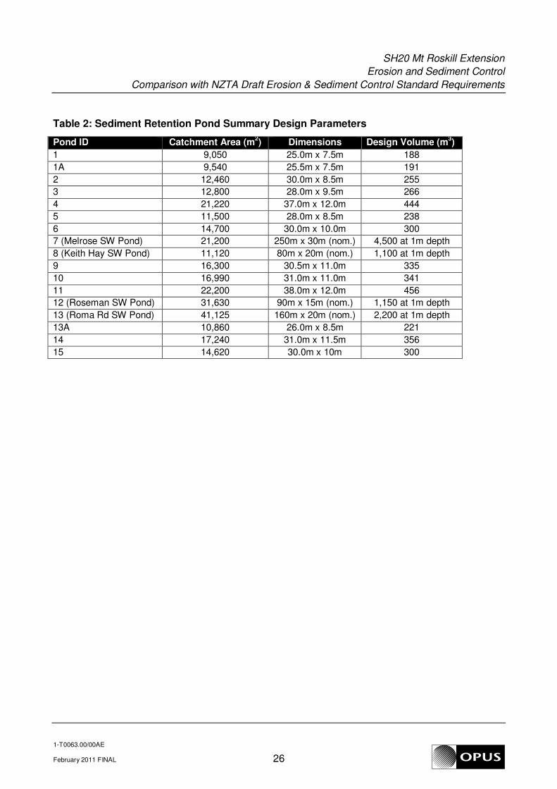
summary design information for each of the SRP is given as Table 2 in Appendix B.
With the exception of the four permanent stormwater ponds, all SRPs were designed on a 2% sizing
basis in accordance with ARC TP90 methodology (i.e. 200 m3
of storage per hectare of catchment
area). Rainfall activated chemical flocculation was required on all temporary sediment control
ponds and on all permanent ponds used as temporary ponds during construction. Diversion
channels were used to convey silt-laden runoff from exposed areas to the SRPs. Perimeter controls
(e.g. silt fences, decanting earth bunds) were also installed, particularly in difficult areas or works in
close proximity to watercourses or drainage systems to provide additional mitigation in these high
risk locations.
As a condition of consent, wheel wash facilities were installed at all entrances/exits to the site to
prevent sediment from being tracked out of the site on vehicle tyres.
Draft NZTA Standard
The location and layout of Sediment Control devices would not be anticipated to vary significantly
had the project been designed using the Draft NZTA Standard. Generally, the design procedures
for the various sediment control practices used on the project are similar under both the Draft NZTA
Standard and ARC TP90.
However, different sizing and decant rate methodologies for storage devices are used by the Draft
NZTA Standard. Due to this difference, the required storage volumes for each device would
increase by around 32% under the Draft NZTA Standard. Additionally, the allowable decant rate
would reduce by approximately 29%, meaning less decants would be required. A comparison table
is given as Table 3 in Appendix B.
Some other minor differences between the Draft NZTA Standard and the project design
methodology (ARC TP90) have been identified, namely;
• The Draft NZTA Standard specifically requires a forebay on all SRPs. This would increase the
total excavation required on each pond as a designated forebay was not strictly required by
ARC TP90.
• The cleanout trigger for silt fences under the Draft NZTA Standard is when accumulated
sediment reaches 20% of the fabric height (vs 50% of the fabric height in ARC TP90). This
would lead to more frequent maintenance of the silt fences.

SH20 Mt Roskill Extension
Erosion and Sediment Control
Comparison with NZTA Draft Erosion & Sediment Control Standard Requirements
1-T0063.00/00AE
February 2011 FINAL 16
3.3.3 Non-sediment Contaminants
Existing Design
Protocols for managing non-sediment contaminants on the SH20 Mt Roskill Extension project were
set out in the site Environmental Management Plan (EMP). This document set out, amongst other
things, the methods and controls for avoiding and mitigating discharges of non-sediment
contaminants on the site including;
• Refuelling and maintenance activities (oil, diesel, lubricants etc.)
• Concrete and grouting (cement, grout, wash-down waste etc.)
• Road sealing/surfacing works (oil, PAHs, bituminous waste etc.)
• Vegetation clearance (woody debris, noxious weeds)
• Sanitary Facilities (toilet and ablutions waste)
• General site waste (litter, construction waste etc.)
• Specific measures for the control of non-sediment contaminants on the SH20 Mt Roskill
Extension project included but were not limited to the following;
• All refuelling and maintenance activities were centralised wherever practicable.
• Bulk fuel, oil and chemical storage areas were provided with secondary containment systems
• Concrete pours were supervised in a manner that avoided/minimised over-pours
• Covers were placed over adjacent stormwater grates during sealing and concreting activities.
• Water based bitumen emulsions were used where practicable to reduce the use of kerosene.
• Felled timber was mulched for landscaping where practicable.
• Clearance of noxious plant material was undertaken in a manner that restricted the spreading
of seeds or plant material.
• Waste construction/demolition materials were cleared as quickly as possible after demolition
• A reputable waste contractor was employed to remove recyclables from the construction site to
an approved recycling facility.
• Sanitary wastes were collected and disposed of off-site by an approved contractor. Portable
units were protected from traffic movement and not located within 10m of any watercourse.
Draft NZTA Standard
Section 10 of the Draft NZTA Standard outlines the potential non-sediment contaminants on state
highway construction projects. This section also outlines the specific measures to be taken to
prevent discharge of non-sediment contaminants from the site.
Generally, the contaminants discussed in the Draft NZTA Standard and the associated control
measures do not differ significantly from those outlined in the project EMP. Accordingly, the
management methods relating to non-sediment contaminants would still have been appropriate had
the project been designed under the Draft NZTA Standard.
However, it is worth noting that the inclusion of what contaminants require consideration and the
defined management protocols within the Draft NZTA Standard may have streamlined the
preparation of the project EMP.

SH20 Mt Roskill Extension
Erosion and Sediment Control
Comparison with NZTA Draft Erosion & Sediment Control Standard Requirements
1-T0063.00/00AE
February 2011 FINAL 17
3.4 Cost
3.4.1 Resource Consents
Existing Design
The Auckland Regional Council consents for the project were the subject of a notified consent
hearing. A subsequent appeal was lodged with the environment court. The estimated cost of
stormwater input to the AEE and for presenting evidence to both the ARC and Environment Court
hearings was approximately $40,000. The proportion of this cost directly attributable to Erosion and
Sediment Control is unavailable as this component was not accounted for individually in the above
costs.
The council consent processing fees and costs associated with the two hearings (e.g. legal fees)
are currently unavailable.
Draft NZTA Standard
As the adoption of the Draft NZTA Standard would not have changed the consenting process, it is
not anticipated that it would have had any impact on the costs related to resource consents.
3.4.2 Final Design
Existing Design
The final detailed design was undertaken by URS Consultants. Based on the best information
available, the design fees for stormwater related works for the project were approximately $390,000.
It is not clear from the available data whether this figure included design of the Erosion and
Sediment Control measures for the project or if so, what proportion of this cost can be attributed to
Erosion and Sediment Control.
Draft NZTA Standard
As the design of the various practices would not have varied significantly under the Draft NZTA
Standard, it is not expected that there would have been any noticeable change to the overall cost of
designing the erosion and sediment control measures on the SH20 Mt Roskill Extension project.

SH20 Mt Roskill Extension
Erosion and Sediment Control
Comparison with NZTA Draft Erosion & Sediment Control Standard Requirements
1-T0063.00/00AE
February 2011 FINAL 18
3.4.3 Construction
Existing Design
The total cost of the Erosion and Sediment Control measures on the SH20 Mt Roskill Extension
project was ~$2.14m (including operation maintenance and management of practices).
The following table provides a breakdown of the costs for the various elements;
Sediment Retention Ponds $ 219,000
Diversion Channels & Bunds $ 191,300
Flocculation Systems $ 48,000
Super Silt Fences $ 36,000
Wheel Wash Systems (Install & Remove) $ 105,000
Stabilisation/Erosion Control $ 115,000
Maintenance of Controls $ 180,000
Environmental Compliance Monitoring and Testing $ 1,250,000
Total Cost Of Erosion & Sediment Control $ 2,140,000
Draft NZTA Standard
Due to the increased volume requirements of the Draft NZTA Standard (refer Section 3.3.2), the
construction cost of the storage devices would increase as larger excavation volumes would have
been required.
Assuming that excavation contributes 50% of the total pond construction cost and given the volume
increase requirement of 32%, the additional cost to the pond construction would be in the order of
$35,000 (0.32 x 0.5 x $219,000) or a 16% increase in the cost of pond construction.
3.4.4 Proportion of Total Cost
Existing Design
The final total project construction cost was around ~$187,000,000.
The construction cost for the Erosion and Sediment Control measures (see Section 3.4.3 above)
was $2,140,000. This represents around 1.14% of the total cost of physical works on the project.
Draft NZTA Standard
It is not anticipated that the adoption of the Draft NZTA Standard would have had a significant effect
on the proportion of the total cost attributable to Erosion and Sediment Control. However, the total
cost would likely have been slightly higher due to the cost of the increased storage volumes (see
above) and more stringent monitoring requirements (see Section 3.4.5)

SH20 Mt Roskill Extension
Erosion and Sediment Control
Comparison with NZTA Draft Erosion & Sediment Control Standard Requirements
1-T0063.00/00AE
February 2011 FINAL 19
3.4.5 Monitoring Costs
Existing Design
The cost of operating, managing and maintaining the Erosion and Sediment Control measures
during construction was approximately $1,250,000 (see Section 3.4.3). This included monitoring,
testing and reporting costs for all erosion and sediment control practices and associated facilities
(e.g. flocculant dosing systems). This does not include the Auckland Regional Council officer’s
monitoring and processing fees.
Draft NZTA Standard
The Draft NZTA Standard requires, at a minimum, water quality monitoring of total suspended
solids, turbidity and pH (when chemical flocculation is used) of the discharge from sediment control
practices. The monitoring protocols are set out in Appendix A of the Draft Standard and reiterated
in the accompanying Field Guide for Contractors. No such requirements are contained in the ARC
consents where monitoring of Erosion and Sediment Control measures was limited to visual
qualitative and quantitative monitoring only.
As the Draft NZTA Standard requires more stringent water quality monitoring than the ARC
resource consents, the cost of monitoring would increase significantly. It is not possible to quantify
the actual cost of the water quality monitoring that would have been required by the Draft NZTA
Standard, but it is estimated that it would be in the order of hundreds of thousands of dollars
additional cost.

SH20 Mt Roskill Extension
Erosion and Sediment Control
Comparison with NZTA Draft Erosion & Sediment Control Standard Requirements
1-T0063.00/00AE
February 2011 FINAL 20
3.5 Time
3.5.1 Resource Consents
Existing Design
The resource consent application was completed in November 2000. The Auckland Regional
Council notified consent hearing was held in March 2002. The Environment Court hearing was held
in June 2002 with a final decision released and resource consents granted in January 2003. This
process took a total of ~26months
Draft NZTA Standard
The processing of resource consents and the approval of the Site Specific Erosion and Sediment
Control Plans may have taken slightly longer had the Erosion and Sediment Control measures been
designed using the Draft NZTA Standard. This is mainly due to the fact that the consenting
authority (ARC) is familiar with the current design guidelines used (ARC TP90) but not so with the
Draft NZTA Standard. The ARC would need to be satisfied that the proposed measures were at
least equivalent to those designed under ARC TP90.
However, due to notified status of the consents and the subsequent Environment Court hearing, the
total time taken to process the consents would not realistically have increased significantly.
3.5.2 Final Design
Existing Design
The initial professional services contract for detailed and preliminary design of the project was
awarded to URS Consultants for a duration of 12 months. All stormwater related design elements
(including Erosion and Sediment Control) were undertaken concurrently with the other design
disciplines during this period.
Value Engineering and other design revisions added a further 6 months to the design timeframe,
giving a total duration for final design of 18 months.
Draft NZTA Standard
The design methodology for storage practices given in the Draft NZTA Standard is slightly more
involved than that used by ARC TP90. This may have added to the time required to design the
individual storage devices. Additionally, the need to determine which document has the more
stringent requirements means that the practices must be designed using both methodologies in
parallel. However, the much extended guidance given for maintenance, monitoring and
decommissioning of the various practices would likely reduce the time required to prepare the
Erosion and Sediment Control Plans themselves.
Due to the above factors, it is considered that the effect of adopting the Draft NZTA Standard for
design of the Erosion and Sediment Control measures on the project would have been time neutral
i.e. no significant increase or decrease in the final design time would be expected.
SH20 Mt Roskill Extension
Erosion and Sediment Control
Comparison with NZTA Draft Erosion & Sediment Control Standard Requirements
1-T0063.00/00AE
February 2011 FINAL 21
3.5.3 Construction
Existing Design
The main construction contract was awarded in August 2005 with the subsequent establishment on
site in September 2005. Under the original terms of the contract the total construction period was
48 months (4 years), giving an original completion date of September 2009.
During the course of construction the scope of the physical works contract was increased due to
various factors resulting in a negotiated completion date of 30 December 2009.
The final physical works completion date was 15 May 2009, seven months ahead of the negotiated
completion date (30 December 2009), giving a total construction duration of 45 months.
Due to staging of works the total time taken to install the Erosion and Sediment Control measures
on the project is unavailable. However, in general terms, temporary sediment retention ponds took
approximately 3 days to construct (including pond excavation and installation of the inlet and outlet
systems). The rainfall activated flocculant dosing system for each pond generally took an additional
day to install and set up. The installation of other controls such as silt fences, diversion channels
and decanting earth bunds generally took 1-2 days depending on size/length.
Draft NZTA Standard
As the design of most Erosion and Sediment Control measures used on the SH20 Mt Roskill
Extension project would not have varied greatly had the Draft NZTA Standard been adopted, it is
expected that the time to construct the majority of measures would not have changed significantly.
The exception to this would be the storage practices. Due to the increased volume requirements of
the Draft NZTA Standard, the time required to excavate ponds and decanting earth bunds would
have increased proportionally (i.e. 32% increase in excavation time).
3.5.4 Monitoring
Existing Design
Monitoring of the Erosion and Sediment Control Measures was undertaken by the ARC on a weekly
basis during construction. This included inspecting and scoring each of the individual Erosion and
Sediment Control Practices within each zone of the work site during site walkovers by ARC
monitoring and compliance staff. No water quality monitoring of pond discharges was undertaken in
relation to sediment control.
Draft NZTA Standard
As adoption of the Draft NZTA Standard would not have significantly altered the conditions of the
various resource consents, the ARC would likely have required the same frequency of monitoring
and the same monitoring regimes to be put in place.
However, the minimum requirements for water quality monitoring set out in Section 7.3 of the Draft
NZTA Standard (see Section 3.4.5) would have significantly increased the man-hours required for
monitoring of the individual devices.

SH20 Mt Roskill Extension
Erosion and Sediment Control
Comparison with NZTA Draft Erosion & Sediment Control Standard Requirements
1-T0063.00/00AE
February 2011 FINAL 22
4 General Comments
4.1 Design/Construction Issues
4.1.1 Design
There were no known design issues relating to Erosion and Sediment Control on the SH20
Mt Roskill Extension project that caused difficulties or time delays during the consenting
process.
4.1.2 Construction
The only known issue relating to Erosion and Sediment Control during construction was an
uncontrolled sediment discharge which occurred in March 2006, where sediment laden
water was able to bypass a decanting earth bund via the granular bedding and backfill
material of an adjacent large diameter pipe trench. This was the subject of an incident
report to ARC. Remedial measures were taken to remedy the problem and site staff made
aware of the potential for water to track through pipe bedding material. This issue did not
cause any significant cost increase or time delay.
4.2 Project Completion
The SH20 Mt Roskill Extension project was completed ahead of time allowing for Time
Extensions granted, and approx 25% (excluding Escalation) above the original Tender
Price, although variations and changes of scope account for most of this increase. Erosion
and Sediment Control works were not the subject of any variation claims for the extended
contract period. Most of the Erosion and Sediment Control works were scheduled as Lump
Sums, so the cost risk was mainly borne by the Contractor.
4.3 Anticipated Effects of Applying Draft NZTA Standard
The most notable expected changes to the design and operation of the Erosion and
Sediment Control measures, had the Draft NZTA Standard been used on the SH20 Mt
Roskill Extension project, would have been;
Increased storage volumes and requirement for forebays on all sediment ponds:
would have led to an increase in excavation volumes and associated time and cost
increases for the construction of these practices.
Increase in water quality monitoring requirements: would have led to a significant
increase in cost and man-hour requirements for monitoring and testing.
Decrease in allowable sediment accumulation behind silt fences: the cleanout trigger
for silt fences under the Draft NZTA Standard (20% vs 50% of the fabric height) would more
than double the maintenance frequency of the silt fences.
It is not anticipated that there would have been any significant streamlining of the design
process. However, the extended guidance given in the document relating to construction,
maintenance and decommissioning of the various practices and detailed guidance for
flocculation systems would have led to improved maintenance regimes and reduced
cost/time for preparation of device management plans

SH20 Mt Roskill Extension
Erosion and Sediment Control
Comparison with NZTA Draft Erosion & Sediment Control Standard Requirements
1-T0063.00/00AE
February 2011 FINAL 23
4.4 General Comments
While the adoption of the Draft NZTA Standard may not have led to significant streamlining
of the design of Erosion and Sediment Controls on the SH20 Mt Roskill Extension project or
cost savings (and in fact would have increased the total cost of Erosion and Sediment
Control due to larger ), it is considered overall to represent an incremental improvement
over current regional guidelines. In particular, the adoption of a risk based approach for
selection of the design storm event is considered to be a more appropriate method for
determining the design runoff volumes as it takes into account the specific characteristics of
the site and receiving environment.
In addition, the inclusion of the Erosion and Sediment Control Field Guide for Contractors
provides invaluable information for the construction, operation, maintenance and
decommissioning of erosion and sediment control in a concise, user-friendly format. It is
expected that this will greatly improve contractors’ understanding of erosion and sediment
control concepts and assist site personnel when undertaking works related to erosion and
sediment control measures.
The inclusion of minimum water quality monitoring requirements, although increasing the
monitoring costs, will ultimately lead to improved device efficiency and design/construction
methodology. The data collected from various construction sites over time will assist in
refining the design parameters and maintenance frequencies, leading to improved
environmental outcomes and reducing the environmental impact of state highway projects
in relation to construction erosion and sediment.

SH20 Mt Roskill Extension
Erosion and Sediment Control
Comparison with NZTA Draft Erosion & Sediment Control Standard Requirements
1-T0063.00/00AE
February 2011 FINAL 24
Appendix A: Design Erosion and Sediment Control Plans


SH20 Mt Roskill Extension
Erosion and Sediment Control
Comparison with NZTA Draft Erosion & Sediment Control Standard Requirements
1-T0063.00/00AE
February 2011 FINAL 25
Appendix B: Design Information
SH20 Mt Roskill Extension
Erosion and Sediment Control
Comparison with NZTA Draft Erosion & Sediment Control Standard Requirements
1-T0063.00/00AE
February 2011 FINAL 26
Table 2: Sediment Retention Pond Summary Design Parameters
Pond ID Catchment Area (m2) Dimensions Design Volume (m
3)
1 9,050 25.0m x 7.5m 188
1A 9,540 25.5m x 7.5m 191
2 12,460 30.0m x 8.5m 255
3 12,800 28.0m x 9.5m 266
4 21,220 37.0m x 12.0m 444
5 11,500 28.0m x 8.5m 238
6 14,700 30.0m x 10.0m 300
7 (Melrose SW Pond) 21,200 250m x 30m (nom.) 4,500 at 1m depth
8 (Keith Hay SW Pond) 11,120 80m x 20m (nom.) 1,100 at 1m depth
9 16,300 30.5m x 11.0m 335
10 16,990 31.0m x 11.0m 341
11 22,200 38.0m x 12.0m 456
12 (Roseman SW Pond) 31,630 90m x 15m (nom.) 1,150 at 1m depth
13 (Roma Rd SW Pond) 41,125 160m x 20m (nom.) 2,200 at 1m depth
13A 10,860 26.0m x 8.5m 221
14 17,240 31.0m x 11.5m 356
15 14,620 30.0m x 10m 300
SH20 Mt Roskill Extension
Erosion and Sediment Control
Comparison with NZTA Draft Erosion & Sediment Control Standard Requirements
1-T0063.00/00AE
February 2011 FINAL 27
Table 3: Sediment Retention Pond Design Comparison