Embed Size (px)
Citation preview

Origin of New RiverIn 1890 a storm brought unusually heavy rain and wind The outlet of Floras Lake just south of here became blocked by sand Flood water flowed into a low channel just east of a low dune paralleling the beach the ldquoforedunerdquo So began a river heading north following this low place until finally reaching the sea A ldquoNew Riverrdquo was born
New River TodayNew River is in constant change High water causes the river to push further north until a low spot in the foredune allows it to reach the sea Some years the river grows a few feet some years a quarter mile
High river water combined with high tides may cause the river to breach the foredune and form a new river mouth Sometimes when flood waters back up into nearby pastures local farmers and the BLM create a breach to drain the land The river may then flow backward
European BeachgrassWhen blowing sand hits plants it falls to the
ground The mound of sand
created becomes
a dune if
the process continues Low dunes along the beach built from native plants are frequently destroyed by high winds or water European beachgrass has such an extensive root system and grows so vigorously that its foredunes may be 30-feet high It was planted in the early 1900s to control blowing
sand and is only one of 75 non-native plants
found in New River ACEC
New River‛s Attractions and RichesHere is one of the last remaining wild places on the Oregon coast Active dunes still blow inland and become stabilized with native pines salal and huckleberry Forests on old dunes contain wetlands with sedges and skunk cabbage and hide lakes inhabited by the Northwestern Pond Turtle Woods of towering waxmyrtles contrast with open sandy areas of ancient manzanitas Meadows kept open by the BLM hold rare native plants Lichens and mosses grow from the ground to the tops of the trees and ferns are everywhere
Look for these features while on the trails Remember tread lightly and leave no trace
Before New River Evidence of large Indian villages from 8000 years ago hides beneath the sand and forest Archaeological digs show that recent ancestors of Siletz and Coquille Indians adapted to huge changes in the area This was a large estuary providing abundant seafood but was destroyed by a 30-foot wall of water from a tsunami in 1700
It wasn‛t long before blowing sand blocked stream outlets to form lakes and marshes Forests grew harboring abundant elk and deer Eventually blowing sand and fires claimed the forests
By the time New River formed the area was all open dunes and wetlands
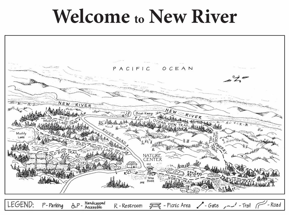
New River ACEC Four sites make up New River ACEC Storm Ranch Floras Lake Fourmile Creek and Lost Lake
has three
e
The Storm Ranch portion miles of trails for hikers horses and bicyclists ThNature Center containinginterpretive displays and information is next to the parking lot along with restrooms and drinking water
Boaters may launch at the end of River Road open to vehicles from September 15 to March 15
While at New River pleaseremember bullPets must be leashed at all times bull Stay on the trails to avoid harming plants and animal habitat bullCollecting plants including mushrooms is not allowed Keep the area pristine bull Move quietly to improve your chances of seeing wildlife of seeing wildlife
What Is An ACEC New River is a 1200-acre Area of Critical Environmental Concern (ACEC) managed by the Bureau of Land Management Special management is required by ACECs to maintain diversity and quality habitat for native communities of plants birds animals and fish New River ACEC also provides protection for cultural sites and offers educational interpretive and recreational opportunities to the public
If you are interested in volunteering at New River reserving the Nature Center bringing a school group or learning more about New River please contact
The Bureau of Land ManagementCoos Bay District Office1300 Airport Lane
North Bend Oregon 97459541-756-0100
BLMORWAGI-13038+1792 (13-0106)
New River Trail Guide
Coos B
ay District
BL
M
Natural history of the area and details of the trail
system at Storm Ranch
New RiverTrail Guide
Natural history of thearea and details of the trail
system at Storm Ranch
New River ACECFour sites make up New River ACEC Storm Ranch Floras Lake Fourmile Creek and Lost Lake
The Storm Ranch portion has three miles of trails for hikers horses and bicyclists The Nature Center containing interpretive displays and information is next to the parking lot along with restrooms and drinking water
Boaters may launch at the end of River Road open to vehicles from September 15 to March 15
While at New River please rememberbullPets must be leashed at all timesbull Stay on the trails to avoid harming plants and animal habitatbullCollecting plants including mushrooms is not allowed Keep the area pristine bull Move quietly to improve your chances of seeing wildlife
What Is An ACECNew River is a 1200-acre Area of Critical Environmental Concern (ACEC) managed by the Bureau of Land Management Special management is required by ACECs to maintain diversity and quality habitat for native communities of plants birds animals and fish New River ACEC also provides protection for cultural sites and offers educational interpretive and recreational opportunities to the public
If you are interested in volunteering atNew River reserving the Nature Centerbringing a school group or learning moreabout New River please contact
The Bureau of Land ManagementCoos Bay District Office1300 Airport Lane
North Bend Oregon 97459541-756-0100
BL
MC
oos
Bay
Dis
tric
t
BLMORWAGI-13038+1792 (13-0106)
Eventually
Origin of New River In 1890 a storm brought unusually heavy rain and wind The outlet of Floras Lake just south of here became blocked by sand Flood water flowed into a low channel just east of a low dune paralleling the beach the ldquoforedunerdquo So began a river heading north following this low place until finally reaching the sea A
European
mound crb
a d
When sand hiit falls
ground
BeachgrassWhen blowing sand hits plants it falls to the
ground The mound of sand
a dune if
of ea
ecun
blts toTh
st
oe
Beachgrasop te
European
and ed
mes if
s wing lants he
one of 75 non-native plants
found in New River ACEC
the process continues Low dunes along the beach built from native plants are frequently destroyed by high winds or water European beachgrass has such an extensive root system and grows so vigorously that its foredunes may be 30-feet high was planted in the early feet high It was planted in the early
to control blowing to control blowing sand and is only sand and is only
found
It 1900s
ldquoNew Riverrdquo was born
New River Today New River is in constant change High water causes the river to push further north until a low spot in the foredune allows it to reach the sea Some years the river grows a few feet some years a quarter mile
High river water combined with high tides may cause the river to breach the foredune and form a new river mouth Sometimes when flood waters back up into nearby pastures local farmers and the BLM create a breach to drain the land The river may then flow backward
New River‛s Attractions and Riches
Look for these features while on the trails Remember tread lightly and leave no trace
Before New River Evidence of large Indian villages from 8000 years ago hides beneath the sand and forest Archaeological digs show that recent ancestors of Siletz and Coquille Indians adapted to huge changes in the area This was a large estuary providing abundant seafood but was destroyed by a 30-foot wall of water from a tsunami in 1700
It wasn‛t long before blowing sand blocked stream outlets to form lakes and marshes Forests grew harboring
open dunes and
sedges and skunk cabbage and
Here is one of the last remaining wild
sedges and skunk cabbage and
abundant elk and deer abundant elk and deer blowing sand and blowing sand and
open dunes and
Eventually places on the Oregon coast Active dunes still blow inland and become fires claimed stabilized with native pines salal the forests and huckleberry Forests on old
By the timedunes contain wetlands with New River formed thehide lakes inhabited by the area was allNorthwestern Pond Turtle
Woods of towering wetlandswaxmyrtles contrast
with open sandy areas of ancient manzanitas Meadows kept open by the BLM hold rare native plants Lichens and mosses grow from the ground to the tops of the trees and ferns are everywhere
Welcome to New River
usually quite wide here look across for
protects wetlands beneath Soon a side trail NEW RIVER LOOKOUT winds through open pine forest to a sandy river viewpoint The river is
ocean A short boardwalk
becomes West Muddy Lake Trail as it heads toward the
to a large meadow where the trail splits to Old Bog Trail trail splits to Old Bog Trail
becomes West Muddy Lake Trail as it heads toward the ocean A short boardwalk protects wetlands beneath Soon a side trail NEW RIVER LOOKOUT winds through open pine forest to a sandy river viewpoint The river is
East Muddy Lake Trail continues to a viewing platform on the edge of a freshwater lake Benches provide a place for quiet viewing Continuing on the path
the top of these barely stabilized dunes
TRAIL DESCRIPTIONS
River Road River Road leaves the parking lot and ends at New River boat ramp This gravel road is always open to foot bicycle and horse traffic but closed to vehicles from March 15 to Sept 15 (a sensitive time for breeding wildlife and young) River‛s edge is an excellent place in spring and fall to watch thousands of geese and shorebirds following New River on their migration The road is nearly flat wheelchair accessible and takes about 15 minutes to walk
Muddy Lake Trail
usually quite wide here look across for birds on the far bank
Begin East Muddy Lake Trail from River Road Forest quickly gives way to a large meadow where the
River Road and Muddy Lake Trails combined form an easy varied 45-minute loop all wheelchair accessible
Old Bog Trail This trail branches off East Muddy Lake Trail and climbs a small sandy hill through a patch of kinnikinnick There is a bench at the end to rest and view what remains of one of the oldest cranberry bogs on the coast planted in 1915 Wild and domestic cranberries were crossed
quarter
to produce a new variety grown here Old Bog Trail is a 20-minute round-trip hike A leisurely walk combining the above trails takes about an hour and a
North Trail Starting north of the parking lot this trail borders the old corrals
of Storm Ranch Notice the ancient manzanitas with peeling red bark Their urn-shaped flowers attract hundreds of hummingbirds
traveling north in the spring A 10-minute walk leads to the start
of the RIDGE TRAIL loop
Ridge Trail Following the top of a stabilized dune this trail is soft sand beneath pine needles Soon a switchback begins descent and the trail becomes enclosed with rhododendrons It dips and climbs several times ending at the intersection of Huckleberry Hill Trail and North Trail Notice the enormous waxmyrtles on this 15-minute loop Notice the enormous waxmyrtles on
uckill andorend dut sre fand
HHSmabas
leberry Trail presents a challenging hike up own the vegetated dunes ome of the best views rom this trail Blowing encroaches on small pines at
more challenging hike up and down the vegetated dunes but some of the best views are from this trail Blowing sand encroaches on small pines at the top of these barely stabilized dunes Low spots on the trail may be flooded in winter Switchbacks and sand stairs end the 20-minute hike to begin the Ocean View Trail
Ocean View Trail Sometimes completely enclosed overhead with tall waxmyrtle this trail is wide and flat A side path marked OVERLOOK provides a view of the river foredune and ocean beyond Ocean View Trail is a 15-minute walk connecting Huckleberry Hill Trail and River Road
An easy pace beginning North Trail and returning River Road takes about an hour and a quarter
TRAIL DESCRIPTIONS
River RoadRiver Road leaves the parking lot and ends at New River boat ramp This gravel road is always open to foot bicycle and horse traffic but closed to vehicles from March 15 to Sept 15 (a sensitive time for breeding wildlife and young) River‛s edge is an excellent place in spring and fall to watch thousands of geese and shorebirds following New River on their migration The road is nearly flat wheelchair accessible and takes about 15 minutes to walk
Muddy Lake TrailBegin East Muddy Lake Trail from River Road Forest quickly gives way to a large meadow where the trail splits to Old Bog Trail East Muddy Lake Trail continues to a viewing platform on the edge of a freshwater lake Benches provide a place for quiet viewing Continuing on the path becomes West Muddy Lake Trail as it heads toward the ocean A short boardwalk protects wetlands beneath Soon a side trail NEW RIVER LOOKOUT winds through open pine forest to a sandy river viewpoint The river is usually quite wide here look across for birds on the far bank
River Road and Muddy LakeTrails combined form an easy varied 45-minute loop all wheelchair accessible
Ridge TrailFollowing the top of a stabilized dune this trail is soft sand beneath pine needles Soon a switchback begins descent and the trail becomes enclosed with rhododendrons It dips and climbs several times ending at the intersection of Huckleberry Hill Trail and North Trail Notice the enormous waxmyrtles on this 15-minute loop
Huckleberry Hill TrailSand presents a more challenging hike up and down the vegetated dunes but some of the best views are from this trail Blowing sand encroaches on small pines at the top of these barely stabilized dunes Low spots on the trail may be flooded in winter Switchbacks and sand stairs end the 20-minute hike to begin the Ocean View Trail
Ocean View Trail Sometimes completely enclosed overhead with tall waxmyrtle this trail is wide and flat A side path marked OVERLOOK provides a view of the river foredune and ocean beyond Ocean View Trail is a 15-minute walk connecting Huckleberry Hill Trail and River Road
An easy pace beginning North Trail and returning River Road takes about an hour and a quarter
Old Bog TrailThis trail branches off East MuddyLake Trail and climbs a small sandy hill through a patch of kinnikinnick There is a bench at the end to rest and view what remains of one of the oldest cranberrybogs on the coast planted in 1915 Wild and domestic cranberries were crossed to produce a new variety grown here Old Bog Trail is a 20-minute round-trip hike A leisurely walk combining the above trails takes about an hour and a quarter
North TrailStarting north of the parking lot this trail borders the old corrals
of Storm Ranch Notice the ancient manzanitas with peeling red bark Their urn-shaped flowers attract hundreds of hummingbirds
traveling north in the spring A 10-minute walk leads to the start
of the RIDGE TRAIL loop
Welcome to New River

Welcome to New River
usually quite wide here look across for
protects wetlands beneath Soon a side trail NEW RIVER LOOKOUT winds through open pine forest to a sandy river viewpoint The river is
ocean A short boardwalk
becomes West Muddy Lake Trail as it heads toward the
to a large meadow where the trail splits to Old Bog Trail trail splits to Old Bog Trail
becomes West Muddy Lake Trail as it heads toward the ocean A short boardwalk protects wetlands beneath Soon a side trail NEW RIVER LOOKOUT winds through open pine forest to a sandy river viewpoint The river is
East Muddy Lake Trail continues to a viewing platform on the edge of a freshwater lake Benches provide a place for quiet viewing Continuing on the path
the top of these barely stabilized dunes
TRAIL DESCRIPTIONS
River Road River Road leaves the parking lot and ends at New River boat ramp This gravel road is always open to foot bicycle and horse traffic but closed to vehicles from March 15 to Sept 15 (a sensitive time for breeding wildlife and young) River‛s edge is an excellent place in spring and fall to watch thousands of geese and shorebirds following New River on their migration The road is nearly flat wheelchair accessible and takes about 15 minutes to walk
Muddy Lake Trail
usually quite wide here look across for birds on the far bank
Begin East Muddy Lake Trail from River Road Forest quickly gives way to a large meadow where the
River Road and Muddy Lake Trails combined form an easy varied 45-minute loop all wheelchair accessible
Old Bog Trail This trail branches off East Muddy Lake Trail and climbs a small sandy hill through a patch of kinnikinnick There is a bench at the end to rest and view what remains of one of the oldest cranberry bogs on the coast planted in 1915 Wild and domestic cranberries were crossed
quarter
to produce a new variety grown here Old Bog Trail is a 20-minute round-trip hike A leisurely walk combining the above trails takes about an hour and a
North Trail Starting north of the parking lot this trail borders the old corrals
of Storm Ranch Notice the ancient manzanitas with peeling red bark Their urn-shaped flowers attract hundreds of hummingbirds
traveling north in the spring A 10-minute walk leads to the start
of the RIDGE TRAIL loop
Ridge Trail Following the top of a stabilized dune this trail is soft sand beneath pine needles Soon a switchback begins descent and the trail becomes enclosed with rhododendrons It dips and climbs several times ending at the intersection of Huckleberry Hill Trail and North Trail Notice the enormous waxmyrtles on this 15-minute loop Notice the enormous waxmyrtles on
uckill andorend dut sre fand
HHSmabas
leberry Trail presents a challenging hike up own the vegetated dunes ome of the best views rom this trail Blowing encroaches on small pines at
more challenging hike up and down the vegetated dunes but some of the best views are from this trail Blowing sand encroaches on small pines at the top of these barely stabilized dunes Low spots on the trail may be flooded in winter Switchbacks and sand stairs end the 20-minute hike to begin the Ocean View Trail
Ocean View Trail Sometimes completely enclosed overhead with tall waxmyrtle this trail is wide and flat A side path marked OVERLOOK provides a view of the river foredune and ocean beyond Ocean View Trail is a 15-minute walk connecting Huckleberry Hill Trail and River Road
An easy pace beginning North Trail and returning River Road takes about an hour and a quarter
TRAIL DESCRIPTIONS
River RoadRiver Road leaves the parking lot and ends at New River boat ramp This gravel road is always open to foot bicycle and horse traffic but closed to vehicles from March 15 to Sept 15 (a sensitive time for breeding wildlife and young) River‛s edge is an excellent place in spring and fall to watch thousands of geese and shorebirds following New River on their migration The road is nearly flat wheelchair accessible and takes about 15 minutes to walk
Muddy Lake TrailBegin East Muddy Lake Trail from River Road Forest quickly gives way to a large meadow where the trail splits to Old Bog Trail East Muddy Lake Trail continues to a viewing platform on the edge of a freshwater lake Benches provide a place for quiet viewing Continuing on the path becomes West Muddy Lake Trail as it heads toward the ocean A short boardwalk protects wetlands beneath Soon a side trail NEW RIVER LOOKOUT winds through open pine forest to a sandy river viewpoint The river is usually quite wide here look across for birds on the far bank
River Road and Muddy LakeTrails combined form an easy varied 45-minute loop all wheelchair accessible
Ridge TrailFollowing the top of a stabilized dune this trail is soft sand beneath pine needles Soon a switchback begins descent and the trail becomes enclosed with rhododendrons It dips and climbs several times ending at the intersection of Huckleberry Hill Trail and North Trail Notice the enormous waxmyrtles on this 15-minute loop
Huckleberry Hill TrailSand presents a more challenging hike up and down the vegetated dunes but some of the best views are from this trail Blowing sand encroaches on small pines at the top of these barely stabilized dunes Low spots on the trail may be flooded in winter Switchbacks and sand stairs end the 20-minute hike to begin the Ocean View Trail
Ocean View Trail Sometimes completely enclosed overhead with tall waxmyrtle this trail is wide and flat A side path marked OVERLOOK provides a view of the river foredune and ocean beyond Ocean View Trail is a 15-minute walk connecting Huckleberry Hill Trail and River Road
An easy pace beginning North Trail and returning River Road takes about an hour and a quarter
Old Bog TrailThis trail branches off East MuddyLake Trail and climbs a small sandy hill through a patch of kinnikinnick There is a bench at the end to rest and view what remains of one of the oldest cranberrybogs on the coast planted in 1915 Wild and domestic cranberries were crossed to produce a new variety grown here Old Bog Trail is a 20-minute round-trip hike A leisurely walk combining the above trails takes about an hour and a quarter
North TrailStarting north of the parking lot this trail borders the old corrals
of Storm Ranch Notice the ancient manzanitas with peeling red bark Their urn-shaped flowers attract hundreds of hummingbirds
traveling north in the spring A 10-minute walk leads to the start
of the RIDGE TRAIL loop
Welcome to New River