Embed Size (px)
Citation preview
Page 21 of 61
HALMAHERA, SERAM & BANDABerita Sedimentologi
Number 23 – March 2012
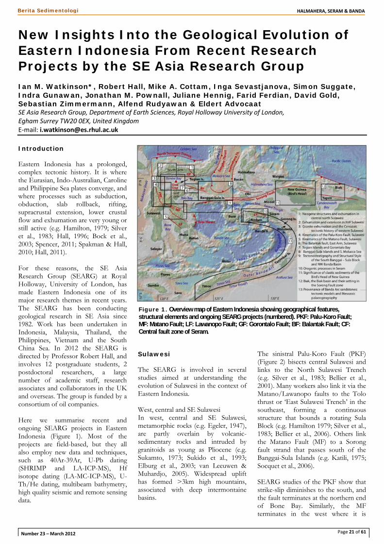
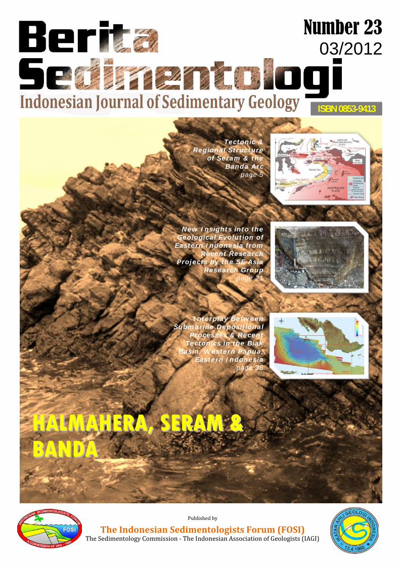
New Insights Into the Geological Evolution ofEastern Indonesia From Recent ResearchProjects by the SE Asia Research GroupIan M. Watkinson*, Robert Hall, Mike A. Cottam, Inga Sevastjanova, Simon Suggate,Indra Gunawan, Jonathan M. Pownall, Juliane Hennig, Farid Ferdian, David Gold,Sebastian Zimmermann, Alfend Rudyawan & Eldert AdvocaatSE Asia Research Group, Department of Earth Sciences, Royal Holloway University of London,Egham Surrey TW20 0EX, United KingdomE-mail: [email protected]
Introduction
Eastern Indonesia has a prolonged,complex tectonic history. It is wherethe Eurasian, Indo-Australian, Carolineand Philippine Sea plates converge, andwhere processes such as subduction,obduction, slab rollback, rifting,supracrustal extension, lower crustalflow and exhumation are very young orstill active (e.g. Hamilton, 1979; Silveret al., 1983; Hall, 1996; Bock et al.,2003; Spencer, 2011; Spakman & Hall,2010; Hall, 2011).
For these reasons, the SE AsiaResearch Group (SEARG) at RoyalHolloway, University of London, hasmade Eastern Indonesia one of itsmajor research themes in recent years.The SEARG has been conductinggeological research in SE Asia since1982. Work has been undertaken inIndonesia, Malaysia, Thailand, thePhilippines, Vietnam and the SouthChina Sea. In 2012 the SEARG isdirected by Professor Robert Hall, andinvolves 12 postgraduate students, 2postdoctoral researchers, a largenumber of academic staff, researchassociates and collaborators in the UKand overseas. The group is funded by aconsortium of oil companies.
Here we summarise recent andongoing SEARG projects in EasternIndonesia (Figure 1). Most of theprojects are field-based, but they allalso employ new data and techniques,such as 40Ar-39Ar, U-Pb dating(SHRIMP and LA-ICP-MS), Hfisotope dating (LA-MC-ICP-MS), U-Th/He dating, multibeam bathymetry,high quality seismic and remote sensingdata.
Sulawesi
The SEARG is involved in severalstudies aimed at understanding theevolution of Sulawesi in the context ofEastern Indonesia.
West, central and SE SulawesiIn west, central and SE Sulawesi,metamorphic rocks (e.g. Egeler, 1947),are partly overlain by volcanic-sedimentary rocks and intruded bygranitoids as young as Pliocene (e.g.Sukamto, 1973; Sukido et al., 1993;Elburg et al., 2003; van Leeuwen &Muhardjo, 2005). Widespread uplifthas formed >3km high mountains,associated with deep intermontainebasins.
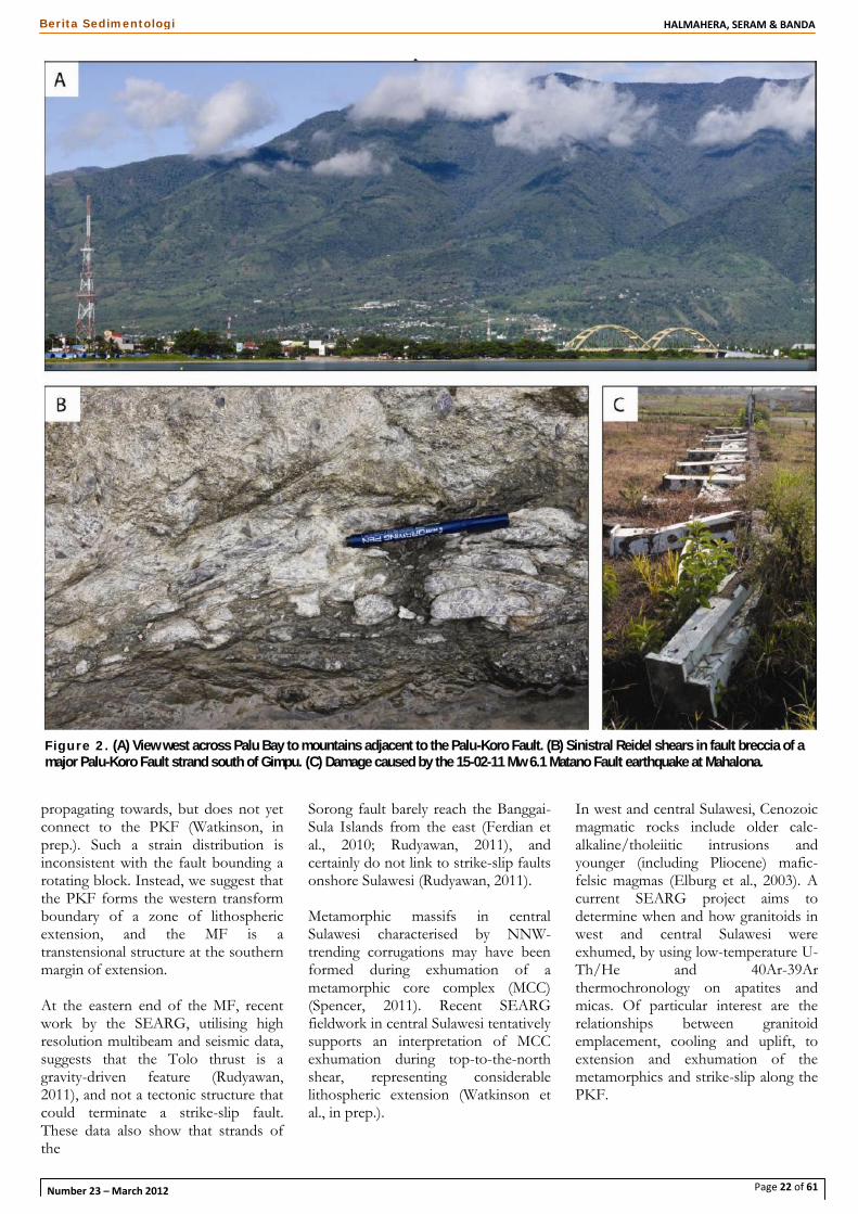
The sinistral Palu-Koro Fault (PKF)(Figure 2) bisects central Sulawesi andlinks to the North Sulawesi Trench(e.g. Silver et al., 1983; Bellier et al.,2001). Many workers also link it via theMatano/Lawanopo faults to the Tolothrust or ‘East Sulawesi Trench’ in thesoutheast, forming a continuousstructure that bounds a rotating SulaBlock (e.g. Hamilton 1979; Silver et al.,1983; Bellier et al., 2006). Others linkthe Matano Fault (MF) to a Sorongfault strand that passes south of theBanggai-Sula Islands (e.g. Katili, 1975;Socquet et al., 2006).
SEARG studies of the PKF show thatstrike-slip diminishes to the south, andthe fault terminates at the northern endof Bone Bay. Similarly, the MFterminates in the west where it is
Figure 1. Overview map of Eastern Indonesia showing geographical features,structural elements and ongoing SEARG projects (numbered). PKF: Palu-Koro Fault;MF: Matano Fault; LF: Lawanopo Fault; GF: Gorontalo Fault; BF: Balantak Fault; CF:Central fault zone of Seram.
Page 22 of 61
HALMAHERA, SERAM & BANDABerita Sedimentologi
Number 23 – March 2012
propagating towards, but does not yetconnect to the PKF (Watkinson, inprep.). Such a strain distribution isinconsistent with the fault bounding arotating block. Instead, we suggest thatthe PKF forms the western transformboundary of a zone of lithosphericextension, and the MF is atranstensional structure at the southernmargin of extension.
At the eastern end of the MF, recentwork by the SEARG, utilising highresolution multibeam and seismic data,suggests that the Tolo thrust is agravity-driven feature (Rudyawan,2011), and not a tectonic structure thatcould terminate a strike-slip fault.These data also show that strands ofthe
Sorong fault barely reach the Banggai-Sula Islands from the east (Ferdian etal., 2010; Rudyawan, 2011), andcertainly do not link to strike-slip faultsonshore Sulawesi (Rudyawan, 2011).
Metamorphic massifs in centralSulawesi characterised by NNW-trending corrugations may have beenformed during exhumation of ametamorphic core complex (MCC)(Spencer, 2011). Recent SEARGfieldwork in central Sulawesi tentativelysupports an interpretation of MCCexhumation during top-to-the-northshear, representing considerablelithospheric extension (Watkinson etal., in prep.).
In west and central Sulawesi, Cenozoicmagmatic rocks include older calc-alkaline/tholeiitic intrusions andyounger (including Pliocene) mafic-felsic magmas (Elburg et al., 2003). Acurrent SEARG project aims todetermine when and how granitoids inwest and central Sulawesi wereexhumed, by using low-temperature U-Th/He and 40Ar-39Arthermochronology on apatites andmicas. Of particular interest are therelationships between granitoidemplacement, cooling and uplift, toextension and exhumation of themetamorphics and strike-slip along thePKF.
Figure 2. (A) View west across Palu Bay to mountains adjacent to the Palu-Koro Fault. (B) Sinistral Reidel shears in fault breccia of amajor Palu-Koro Fault strand south of Gimpu. (C) Damage caused by the 15-02-11 Mw 6.1 Matano Fault earthquake at Mahalona.
Page 23 of 61
HALMAHERA, SERAM & BANDABerita Sedimentologi
Number 23 – March 2012
Tomini Bay
The Gorontalo Basin of Tomini Bay isa deep, enigmatic basin, containing upto 5 km of sediment (Hamilton, 1979).New field, geochemical andgeophysical studies by the SEARG arerevealing more about the basin.Cottam et al. (2011) presented a newstratigraphy for the Togian Islands, inthe centre of Tomini Bay, andinterpreted the age, character andevolution of the basin. The westernend is underlain by continental crust,the central part by Eocene to Mioceneoceanic and arc rocks, with thepossibility of Banggai-Sulamicrocontinental crust south of theTogian Islands. Field relationshipsindicate a latest Miocene to Plioceneage for inception of the basin.Volcanism in the Togian Islands is nota result of Celebes Sea subduction.Instead, it is the result of extension inthe Pliocene and Pleistocene. Modernvolcanism at Una Una may be theresult of the same process (Cottam etal., 2011).
Sulawesi’s North Arm
In the western north arm, the MalinoMetamorphic Complex (MMC)
contains gneisses and schists with agreenschist carapace, and may be aMCC (Kavalieris et al., 1992; vanLeeuwen et al., 2007). The SEARG isundertaking detailed field andthermochronological investigations todetermine whether the MMC is indeeda MCC similar to those of centralSulawesi, and whether it formed/isforming during the same phase ofextension. A related project on theNeogene tectonics of the central northarm aims to understand relationshipsbetween the Gorontalo Fault,intermontaine basins and uplift east ofthe MMC. Igneous rocks, including anunexpectedly large quantity of felsicmaterial, will be used to determineemplacement ages and uplift rates.
Banggai-Sula Islands
The Banggai-Sula microcontinent haslong been considered to have beensliced from New Guinea and travelledwest along strands of the Sorong Fault(e.g. Visser & Hermes, 1962; Hamilton,1979; Silver & Smith, 1983). Collisionof the microcontinent with the eastarm of Sulawesi has been thought tohave caused deformation throughoutSulawesi (e.g. Bergman et al., 1996;
Simandjuntak & Barber, 1996; Calvert,2000; McClay et al., 2000).
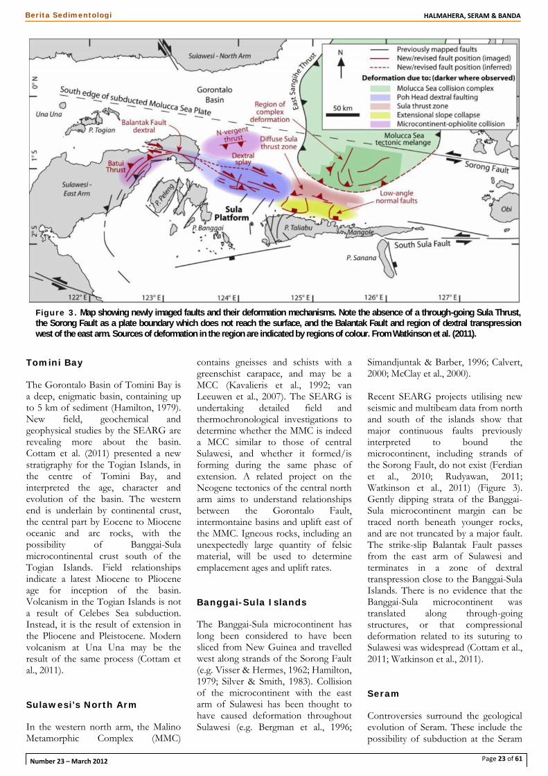
Recent SEARG projects utilising newseismic and multibeam data from northand south of the islands show thatmajor continuous faults previouslyinterpreted to bound themicrocontinent, including strands ofthe Sorong Fault, do not exist (Ferdianet al., 2010; Rudyawan, 2011;Watkinson et al., 2011) (Figure 3).Gently dipping strata of the Banggai-Sula microcontinent margin can betraced north beneath younger rocks,and are not truncated by a major fault.The strike-slip Balantak Fault passesfrom the east arm of Sulawesi andterminates in a zone of dextraltranspression close to the Banggai-SulaIslands. There is no evidence that theBanggai-Sula microcontinent wastranslated along through-goingstructures, or that compressionaldeformation related to its suturing toSulawesi was widespread (Cottam et al.,2011; Watkinson et al., 2011).
Seram
Controversies surround the geologicalevolution of Seram. These include thepossibility of subduction at the Seram
Figure 3. Map showing newly imaged faults and their deformation mechanisms. Note the absence of a through-going Sula Thrust,the Sorong Fault as a plate boundary which does not reach the surface, and the Balantak Fault and region of dextral transpressionwest of the east arm. Sources of deformation in the region are indicated by regions of colour. From Watkinson et al. (2011).
Page 24 of 61
HALMAHERA, SERAM & BANDABerita Sedimentologi
Number 23 – March 2012
trough (e.g. Hamilton, 1979; Karig etal., 1987); thrust sheet emplacementand ophiolite obduction (e.g. Audley-Charles et al., 1979; Linthout &Helmers, 1994); and the causes ofanatexis and cordierite-rich volcanism(Linthout & Helmers, 1994; Honthaaset al., 1999).
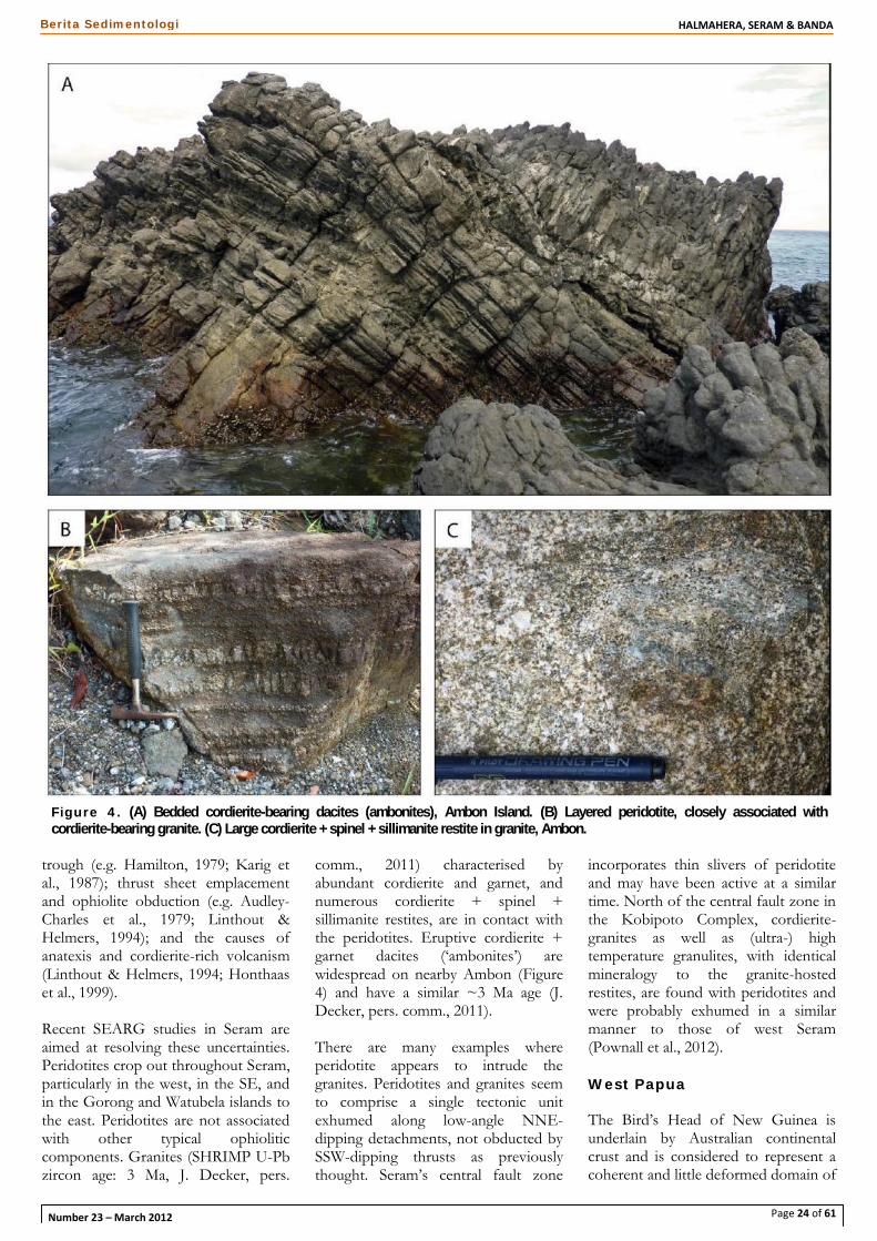
Recent SEARG studies in Seram areaimed at resolving these uncertainties.Peridotites crop out throughout Seram,particularly in the west, in the SE, andin the Gorong and Watubela islands tothe east. Peridotites are not associatedwith other typical ophioliticcomponents. Granites (SHRIMP U-Pbzircon age: 3 Ma, J. Decker, pers.
comm., 2011) characterised byabundant cordierite and garnet, andnumerous cordierite + spinel +sillimanite restites, are in contact withthe peridotites. Eruptive cordierite +garnet dacites (‘ambonites’) arewidespread on nearby Ambon (Figure4) and have a similar ~3 Ma age (J.Decker, pers. comm., 2011).
There are many examples whereperidotite appears to intrude thegranites. Peridotites and granites seemto comprise a single tectonic unitexhumed along low-angle NNE-dipping detachments, not obducted bySSW-dipping thrusts as previouslythought. Seram’s central fault zone
incorporates thin slivers of peridotiteand may have been active at a similartime. North of the central fault zone inthe Kobipoto Complex, cordierite-granites as well as (ultra-) hightemperature granulites, with identicalmineralogy to the granite-hostedrestites, are found with peridotites andwere probably exhumed in a similarmanner to those of west Seram(Pownall et al., 2012).
West Papua
The Bird’s Head of New Guinea isunderlain by Australian continentalcrust and is considered to represent acoherent and little deformed domain of
Figure 4. (A) Bedded cordierite-bearing dacites (ambonites), Ambon Island. (B) Layered peridotite, closely associated withcordierite-bearing granite. (C) Large cordierite + spinel + sillimanite restite in granite, Ambon.
Page 25 of 61
HALMAHERA, SERAM & BANDABerita Sedimentologi
Number 23 – March 2012
Australian affinity with a relativelycomplete Palaeozoic to Recentstratigraphy (e.g. Dow et al., 1988;Audley–Charles, 1991).
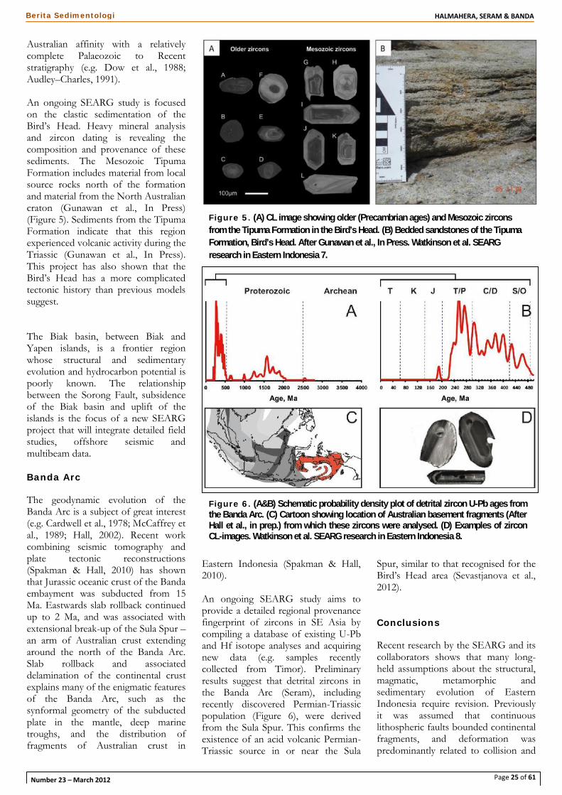
An ongoing SEARG study is focusedon the clastic sedimentation of theBird’s Head. Heavy mineral analysisand zircon dating is revealing thecomposition and provenance of thesesediments. The Mesozoic TipumaFormation includes material from localsource rocks north of the formationand material from the North Australiancraton (Gunawan et al., In Press)(Figure 5). Sediments from the TipumaFormation indicate that this regionexperienced volcanic activity during theTriassic (Gunawan et al., In Press).This project has also shown that theBird’s Head has a more complicatedtectonic history than previous modelssuggest.
The Biak basin, between Biak andYapen islands, is a frontier regionwhose structural and sedimentaryevolution and hydrocarbon potential ispoorly known. The relationshipbetween the Sorong Fault, subsidenceof the Biak basin and uplift of theislands is the focus of a new SEARGproject that will integrate detailed fieldstudies, offshore seismic andmultibeam data.
Banda Arc
The geodynamic evolution of theBanda Arc is a subject of great interest(e.g. Cardwell et al., 1978; McCaffrey etal., 1989; Hall, 2002). Recent workcombining seismic tomography andplate tectonic reconstructions(Spakman & Hall, 2010) has shownthat Jurassic oceanic crust of the Bandaembayment was subducted from 15Ma. Eastwards slab rollback continuedup to 2 Ma, and was associated withextensional break-up of the Sula Spur –an arm of Australian crust extendingaround the north of the Banda Arc.Slab rollback and associateddelamination of the continental crustexplains many of the enigmatic featuresof the Banda Arc, such as thesynformal geometry of the subductedplate in the mantle, deep marinetroughs, and the distribution offragments of Australian crust in
Eastern Indonesia (Spakman & Hall,2010).
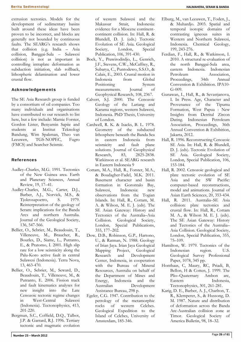
An ongoing SEARG study aims toprovide a detailed regional provenancefingerprint of zircons in SE Asia bycompiling a database of existing U-Pband Hf isotope analyses and acquiringnew data (e.g. samples recentlycollected from Timor). Preliminaryresults suggest that detrital zircons inthe Banda Arc (Seram), includingrecently discovered Permian-Triassicpopulation (Figure 6), were derivedfrom the Sula Spur. This confirms theexistence of an acid volcanic Permian-Triassic source in or near the Sula
Spur, similar to that recognised for theBird’s Head area (Sevastjanova et al.,2012).
Conclusions
Recent research by the SEARG and itscollaborators shows that many long-held assumptions about the structural,magmatic, metamorphic andsedimentary evolution of EasternIndonesia require revision. Previouslyit was assumed that continuouslithospheric faults bounded continentalfragments, and deformation waspredominantly related to collision and
Figure 5. (A) CL image showing older (Precambrian ages) and Mesozoic zirconsfrom the Tipuma Formation in the Bird’s Head. (B) Bedded sandstones of the TipumaFormation, Bird’s Head. After Gunawan et al., In Press. Watkinson et al. SEARGresearch in Eastern Indonesia 7.
Figure 6. (A&B) Schematic probability density plot of detrital zircon U-Pb ages fromthe Banda Arc. (C) Cartoon showing location of Australian basement fragments (AfterHall et al., in prep.) from which these zircons were analysed. (D) Examples of zirconCL-images. Watkinson et al. SEARG research in Eastern Indonesia 8.
Page 26 of 61
HALMAHERA, SERAM & BANDABerita Sedimentologi
Number 23 – March 2012
extrusion tectonics. Models for thedevelopment of sedimentary basinsbuilt around these ideas have beenproven to be incorrect, and blocks aregenerally not bounded by continuousfaults. The SEARG’s research showsthat collision (e.g. India – Asiacollision, Banggai-Sula – Sulawesicollision) is not as important incontrolling intraplate deformation assubduction initiation, slab rollback,lithospheric delamination and lowercrustal flow.
Acknowledgements
The SE Asia Research group is fundedby a consortium of oil companies. Toomany individuals and organisationshave contributed to our research to listhere, but a few include: Marnie Forster,Gordon Lister, Benyamin Sapiie andstudents at Institut TeknologiBandung, Wim Spakman, Theo vanLeeuwen, TGS-NOPEC, Fugro(FMCS) and Searcher Seismic.
References
Audley–Charles, M.G. 1991. Tectonicsof the New Guinea area. Earthand Planetary Sciences, AnnualReview, 19, 17–41.
Audley-Charles, M.G., Carter, D.J.,Barber, A.J., Norvick, M.S., &Tjokrosapoetro, S. 1979.Reinterpretation of the geology ofSeram: implications for the BandaArcs and northern Australia.Journal of the Geological Society,136, 547-566.
Bellier, O., Sebrier, M., Beaudouin, T.,Villeneuve, M., Braucher, R.,Bourles, D., Siame, L., Putranto,E., & Pratomo, I. 2001. High sliprate for a low seismicity along thePalu-Koro active fault in centralSulawesi (Indonesia). Terra Nova,13, 463-470.
Bellier, O., Sebrier, M., Seward, D.,Beaudouin, T., Villeneuve, M., &Putranto, E. 2006. Fission trackand fault kinematics analyses fornew insight into the LateCenozoic tectonic regime changesin West-Central Sulawesi(Indonesia). Tectonophysics, 413,201-220.
Bergman, S.C., Coffield, D.Q., Talbot,J.P. & Garrard, R.J. 1996. Tertiarytectonic and magmatic evolution
of western Sulawesi and theMakassar Strait, Indonesia:evidence for a Miocene continent-continent collision. In: Hall, R. &Blundell, D. J. (eds.) TectonicEvolution of SE Asia. GeologicalSociety, London, SpecialPublication, 106, 391-430.
Bock, Y., Prawirodirdjo, L., Genrich,J.F., Stevens, C.W., McCaffrey, R.,Subarya, C., Puntodewo, S.S.O., &Calais, E., 2003. Crustal motion inIndonesia from GlobalPositioning Systemmeasurements. Journal ofGeophysical Research, 108, 2367.
Calvert, S.J. 2000. The CenozoicGeology of the Lariang andKarama regions, western Sulawesi,Indonesia. PhD Thesis, Universityof London.
Cardwell, R. K. & Isacks, B. L. 1978.Geometry of the subductedlithosphere beneath the Banda Seain eastern Indonesia fromseismicity and fault planesolutions. Journal of GeophysicalResearch, 83, 2825-2838.Watkinson et al. SEARG researchin Eastern Indonesia 9
Cottam, M.A., Hall, R., Forster, M.A.,& Boudagher-Fadel, M.K. 2011.Basement character and basinformation in Gorontalo Bay,Sulawesi, Indonesia: newobservations from the TogianIslands. In: Hall, R., Cottam, M.A. & Wilson, M. E. J. (eds). TheSE Asian Gateway: History andTectonics of the Australia–AsiaCollision. Geological Society,London, Special Publications,355, 177–202.
Dow, D.B., Robinson, G.P., Hartono,U., & Ratman, N. 1988. Geologyof Irian Jaya. Irian Jaya GeologicalMapping Project, GeologicalResearch and DevelopmentCenter, Indonesia, in cooperationwith the Bureau of MineralResources, Australia on behalf ofthe Department of Mines andEnergy, Indonesia and theAustralian DevelopmentAssistance Bureau, 298 p.
Egeler, C.G. 1947. Contribution to thepetrology of the metamorphicrocks of western Celebes.Geological Expedition to theIsland of Celebes, University ofAmsterdam, 185-346.
Elburg, M., van Leeuwen, T., Foden, J.,& Muhardjo. 2003. Spatial andtemporal isotopic domains ofcontrasting igneous suites inWestern and Northern Sulawesi,Indonesia. Chemical Geology,199, 243-276.
Ferdian, F., Hall, R., & Watkinson, I.2010. A structural re-evaluation ofthe north Banggai-Sula area,eastern Indonesia. IndonesianPetroleum Association,Proceedings, 34th AnnualConvention & Exhibition. IPA10-G-009.
Gunawan, I., Hall, R., & Sevastjanova,I. In Press. Age, Character andProvenance of the TipumaFormation, West Papua : NewInsights from Detrital ZirconDating. Indonesian PetroleumAssociation, Proceedings, 36thAnnual Convention & Exhibition,Jakarta, 2012.
Hall, R. 1996. Reconstructing CenozoicSE Asia. In: Hall, R. & Blundell,D. J. (eds). Tectonic Evolution ofSE Asia. Geological Society,London, Special Publication, 106,153-184.
Hall, R. 2002. Cenozoic geological andplate tectonic evolution of SEAsia and the SW Pacific:computer-based reconstructions,model and animations. Journal ofAsian Earth Sciences, 20, 353-434.
Hall, R. 2011. Australia–SE Asiacollision: plate tectonics andcrustal flow. In: Hall, R., CottamM. A., & Wilson M. E. J. (eds).The SE Asian Gateway: Historyand Tectonics of the Australia–Asia Collision. Geological Society,London, Special Publication, 355,75–109.
Hamilton, W. 1979. Tectonics of theIndonesian region. U.S.Geological Survey ProfessionalPaper, 1078, 345 pp.
Honthaas, C, Maury, RC, Priadi, B,Bellon, H & Cotten, J. 1999. ThePlio–Quaternary Ambon arc,Eastern Indonesia,Tectonophysics, 301, 261-281.
Karig, D. E., Barber, A. J., Charlton, T.R., Klemperer, S., & Hussong, D.M. 1987. Nature and distributionof deformation across the BandaArc-Australian collision zone atTimor. Geological Society ofAmerica Bulletin, 98, 18–32.
Page 27 of 61
HALMAHERA, SERAM & BANDABerita Sedimentologi
Number 23 – March 2012
Katili, J.A. 1975. Volcanism And PlateTectonics in the IndonesianIsland Arcs. Tectonophysics, 26,165-188.
Kavalieris, I., van Leeuwen, T.M., &Wilson, M. 1992. Geologicalsetting and styles ofmineralisation, north arm ofSulawesi, Indonesia. Journal ofSoutheast Asian Earth Sciences, 7,113-130. Watkinson et al. SEARGresearch in Eastern Indonesia 10
Linthout, K., & Helmers, H. 1994,Pliocene obducted, rotated andmigrated ultramafic rocks andobduction-induced anatecticgranite, SW Seram and Ambon,Eastern Indonesia. Journal ofSoutheast Asian Earth Sciences, 9,95-109.
McCaffrey, R. 1989. Seismologicalconstraints and speculations onBanda arc tectonics. NetherlandsJournal of Sea Research, 24, 141-152.
McClay, K., Dooley, T., Ferguson, A.& Poblet, J. 2000. Tectonicevolution of the Sanga SangaBlock, Mahakam Delta,Kalimantan, Indonesia. AmericanAssociation of PetroleumGeologists Bulletin, 84, 765-786.
Pownall, J.M., Hall, R., and Watkinson,I.M., 2012. Intrusive peridotitesand granites exhumed on Seramand Ambon, eastern Indonesiaduring Banda Arc subductionrollback (abstract). TectonicStudies Group AGM, Edinburgh,Scotland.
Rudyawan, A. 2011. Tectono-stratigraphy and Structural Styleof The South Banggai – SulaBlock and NW Banda Basin,Indonesia. Unpublished MSc.Thesis, University of London,London, UK.
Sevastjanova, I., Hall, R., &Zimmermann, S. 2012. Detritalzircon provenance and insightsinto palaeogeographic recon-
structions of the Banda Arc(abstract). 1° CongressoInternacional de Geologia deTimor-Leste, Dili, Timor-Leste.
Silver, E.A. & Smith, R.B. 1983.Comparison of terrane accretionin modern Southeast Asia and theMesozoic North AmericanCordillera. Geology, 11, 198-202.
Silver, E.A., Mccaffrey, R., & Smith,R.B. 1983. Collision, rotation andthe initiation of subduction in theevolution of Sulawesi, Indonesia.Journal of Geophysical Research,88, 9407-9418.
Simandjuntak, T.O. & Barber, A.J.1996. Contrasting Tectonic Stylesin the Neogene Orogenic Belts ofIndonesia. In: Hall, R. & Blundell,D. J. (eds). Tectonic Evolution ofSE Asia. Geological Society,London, Special Publication, 106,185-201.
Socquet, A., Simons, W., Vigny, C.,McCaffrey, R., Ambrosius, B.,Spakman, W., Subarya, C. &Sarsito, D. 2006. Microblockrotations and fault coupling in SEAsia triple junction (Sulawesi,Indonesia) from GPS andearthquake slip vector data.Journal of Geophysical Research,111, doi:10.1029/2005JB003963.
Spakman, W., & Hall, R. 2010. Surfacedeformation and slab-mantleinteraction during Banda arcsubduction rollback. NatureGeoscience, 3, 562-566.
Spencer, J.E., 2011. Gently dippingnormal faults identified withSpace Shuttle radar topographydata in central Sulawesi,Indonesia, and some implicationsfor fault mechanics. Earth andPlanetary Science Letters, 308,267-276.
Sukamto, R. 1973. Reconnaissancegeologic map of Palu Area,Sulawesi - scale 1:250,000.Geological Survey of Indonesia,Directorate of Mineral Resources,
Geological Research andDevelopment Centre, Bandung.
Sukido, D., Sukarna, & Sutisna, K.1993. Geological map of thePasangkayu quadrangle, Sulawesi– scale 1:250,000. GeologicalSurvey of Indonesia, Directorateof Mineral Resources, GeologicalResearch and DevelopmentCentre, Bandung.
van Leeuwen, T.M., & Muhardjo.2005. Stratigraphy and tectonicsetting of the Cretaceous andPaleogene volcanic-sedimentarysuccessions in northwest Sulawesi,Indonesia implications for theCenozoic evolution of Westernand Northern Sulawesi. Journal ofAsian Earth Sciences, 25, 481–511. Watkinson et al. SEARGresearch in Eastern Indonesia 11
van Leeuwen, T., Allen, C.M.,Kadarusman, A., Elburg, M.,Palin, J.M., Muhardjo, &Suwijanto. 2007. Petrologic,isotopic, and radiometric ageconstraints on the origin andtectonic history of the MalinoMetamorphic Complex, NWSulawesi, Indonesia. Journal ofAsian Earth Sciences, 29, 751-777.
Visser, W.A. & Hermes, J.J. 1962.Geological results of theexploration for oil in NetherlandsNew Guinea. VerhandelingenKoninklijk NederlandsGeologisch en MijnbouwkundigGenootschap, Geologische Serie,265 pp.
Watkinson, I. M., Hall, R. & Ferdian,F. 2011. Tectonic re-interpretation of the Banggai-Sula–Molucca Sea margin,Indonesia. In: Hall, R., Cottam,M. A. & Wilson, M. E. J. (eds).The SE Asian Gateway: Historyand Tectonics of the Australia–Asia Collision. Geological Society,London, Special Publications, 355,203–224.
Page 1 of 61
Berita Sedimentologi HALMAHERA, SERAM & BANDA
Number 23 – March 2012
Published byThe Indonesian Sedimentologists Forum (FOSI)The Sedimentology Commission - The Indonesian Association of Geologists (IAGI)
HHAALLMMAAHHEERRAA,, SSEERRAAMM &&BBAANNDDAA
Tectonic &Regional Structure
of Seram & theBanda Arc
page 5
New Insights into theGeological Evolution of
Eastern Indonesia fromRecent Research
Projects by the SE AsiaResearch Group
page 21
Interplay BetweenSubmarine Depositional
Processes & RecentTectonics in the Biak
Basin, Western Papua,Eastern Indonesia
page 36
Number 2303/2012
ISBN 0853-9413

![BERITA Number 42 01 / 2019 SEDIMENTOLOGI - iagi.or.id · Berita Sedimentologi [Pick the date] Number 42 –January 2019 Page 4 of 53 About FOSI he forum was founded in 1995 as the](https://img.pdfslide.us/doc/110x75/5c9014e109d3f2a94f8b9e87/berita-number-42-01-2019-sedimentologi-iagiorid-berita-sedimentologi-pick.jpg)