Embed Size (px)
Citation preview
1
New Georadar EU-Development: the GIGA Project
Guido Manacorda Head of Equipment Engineering Group, Georadar Division
IDS Ingegneria dei Sistemi SpA Pisa, Italy
Howard Scott
Managing Director OSYS Technology Limited
Newcastle upon Tyne, United Kingdom
Dave Pinchbeck General Secretary
GERG – The European Gas Research Group Brussels, Belgium
Jean-Pierre Capdevielle
Research and Development Division – Distribution Technologies Section Gaz de France Paris, France
Meinolf Rameil
Head of technology. / Comm. Coordination Department Tracto-Technik Spezialmaschinen (TT Group)
Lennestadt, Germany
ABSTRACT The steadily increasing demand for natural gas necessitates the development of safe, well-
controlled and reliable gas networks, at minimal cost. A similar situation exists in the telecommunications industry where there is a voracious demand for increased capacity and new installations. For utilities wishing to install new infrastructure, this presents problems associated with the detection and location of buried objects, particularly small non-metallic pipelines and cables, in difficult soil conditions. No-Dig technologies offer a cost effective and non-disruptive method of installing new buried pipes and cables, but their safe application in congested urban situations depends upon an accurate and reliable knowledge of the positions and depths of the existing buried utilities infrastructure.
For this purpose, Ground Probing Radar (GPR) technique is very attractive because, amongst the various state-of-the-art methods available, it is the only one capable of accurately locating both metallic and non-metallic buried objects, without prior knowledge of their position.
State-of-the-art GPR can provide location accuracy of a few tens of centimetres to depths of about 1 metre. Performance, however, can be extremely dependent on the pipe material and the soil type, with some combinations of ground conditions and target type and depth posing challenging problems even for the most capable of GPR systems.
Given that safety of the European Citizens is of primary importance, the European Commission has funded the GIGA collaborative research project to establish methods of improving the detection capability of GPR to a level where it can confidently be relied upon to locate all types of pipes and cables buried in a diverse range of soil types, whatever the moisture content.
Keywords: Utilities location techniques – Ground Penetrating radar – Trenchless Technologies –
2
1. INTRODUCTION Industrial societies have grown to be dependant upon services that are delivered by
infrastructure buried in the ground, principally in roadways. The economic and safety implications of disruption to these services can be extremely serious. Not only is there a significant quantity of legacy systems, there is also a continual investment in new and replacement systems.
The worldwide demand for the telecommunication links is rapidly growing and consequently is also raising the need for new installations, especially for connecting many potential users to the ISDN services (Internet, Cable TV, etc.). Moreover, the demand for natural gas is growing as well and it requires the development of safe, well-controlled and reliable gas networks.
For the installation of all new underground infrastructure, trenchless techniques such as
Horizontal Directional Drilling or Pipe Bursting can play a key role, particularly where it is important to reduce disturbance to traffic and people living nearby. However, using such techniques, without reliable information on existing utilities and the local geology, can be problematic, even dangerous. For example, it is worth noting that, in Europe, during new installations, about 90,000 incidences of third party damage to gas pipelines are reported every year and 100,000 in USA. There is little doubt that these instances of damage would be reduced by the use of reliable location techniques.
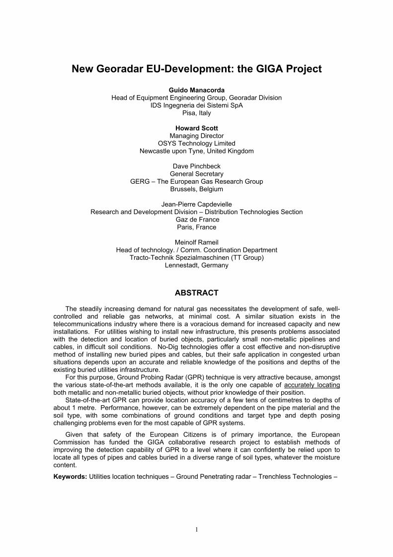
Figure 1. Example of pipe buried in wet clay
However, the detection of utilities’ plant imposes a particular set of constraints on the design of an effective sub-surface radar system or GPR. The majority of buried plant is within 1.5 to 2 metres of the ground surface, but it may have a wide variation in its size, may be metallic or non-metallic, may be in close proximity to other plant and may be buried in a wide range of soil types with implications for large differences in both the absorption and the velocity of propagation of electro-magnetic waves.
The ground conditions may also vary rapidly within the area of a radar survey where, for example, variations in water content can be crucial and, particularly in urban areas, where there could be imported backfill of inconsistent quality. Consequently, it can be extremely problematic to achieve both adequate penetration of the radar pulse and good resolution of neighbouring plant and some design compromises may have to be made.
3
Surprisingly, current developments in GPR are oriented towards visualisation improvement, such as 3-dimensional plots, and GPS positioning, with no attention paid to addressing the basic radar signal detection problem, which can be extremely challenging. Clearly, such developments will not increase system sensitivity but will merely improve the aesthetics of the display. If the received signal is too weak, as would be the case in wet, muddy ground, enhanced graphic software will solve neither the basic signal problem nor the detection performance.
The GIGA project, a European Commission funded collaborative research study, aims to inform and enable the design and build of a new and reliable Ground Penetrating Radar; it involves End-Users and GPR suppliers, thus combining bottom-up and top-down approaches in GPR innovative research.
2. GPR FUNDAMENTALS Radar is well-known for its ability to detect aircraft, ships, vehicles, birds, rainstorms and other
above-ground objects. It relies for its operation on the transmission of electro-magnetic energy, usually in the form of a pulse, and the detection of the small amount of energy that is reflected from the target. The round-trip transit time of the pulse and its reflection provide range information on the target.
Buried objects can also be detected by radar and there are details of such work dating back to 1910, with the first pulsed experiments reported in 1926 when the depths of rock strata were determined by time-of-flight methods. The technique has since been used extensively in geophysical and geological investigation of, for example, salt and mineral deposits, rock strata, ice, fresh-water lake beds, coal seams and desert sand, with the emphasis usually on deep penetration, sometimes up to a few kilometres. Deep penetration requires operation at frequencies of a few MHz or tens of MHz, with the consequent need for large antennas and the accompanying consequence of low resolution of the objects detected.
It is also possible to detect shallow objects within the first one or two metres of the Earth’s surface, which include those of most interest to utilities, by using radar emissions at higher frequencies, up to 1000 MHz, for example. This enables a larger signal bandwidth to be transmitted that allows the higher resolution probing necessary for resolving small, closely spaced, items.
Applications include civil engineering site investigations, determination of the integrity of foundations and retaining walls, detection of voids and mineshafts, investigation of road and rail beds, as well as the location of cables, ducts and pipes (metallic or non-metallic).
Optimum sub-surface radar system performance, particularly for the high-resolution detection of shallow objects, is obtained when the whole of the system is designed around a specific target type or geometry.
The detection of utilities’ plant imposes a particular set of constraints on the design of an effective sub-surface radar system.
The majority of buried plant is within 1.5 to 2 metres of the ground surface, but there may be a wide variation in size and material (metallic or non-metallic), items may be in close proximity to each other and may be buried in a wide range of soil types with possible large differences in both the absorption and the velocity of propagation of electro-magnetic waves.
The ground conditions can also vary rapidly within the area of a radar survey. For example, variations in water content can be crucial and, particularly in urban areas, where imported backfill of inconsistent quality is not uncommon. Consequently, it can be extremely difficult to achieve both adequate penetration of the radar pulse into the soil and good resolution of closely spaced plant; inevitably, design compromises are necessary.
However, radar is the only non-invasive technique presently available that locates non-metallic buried objects.
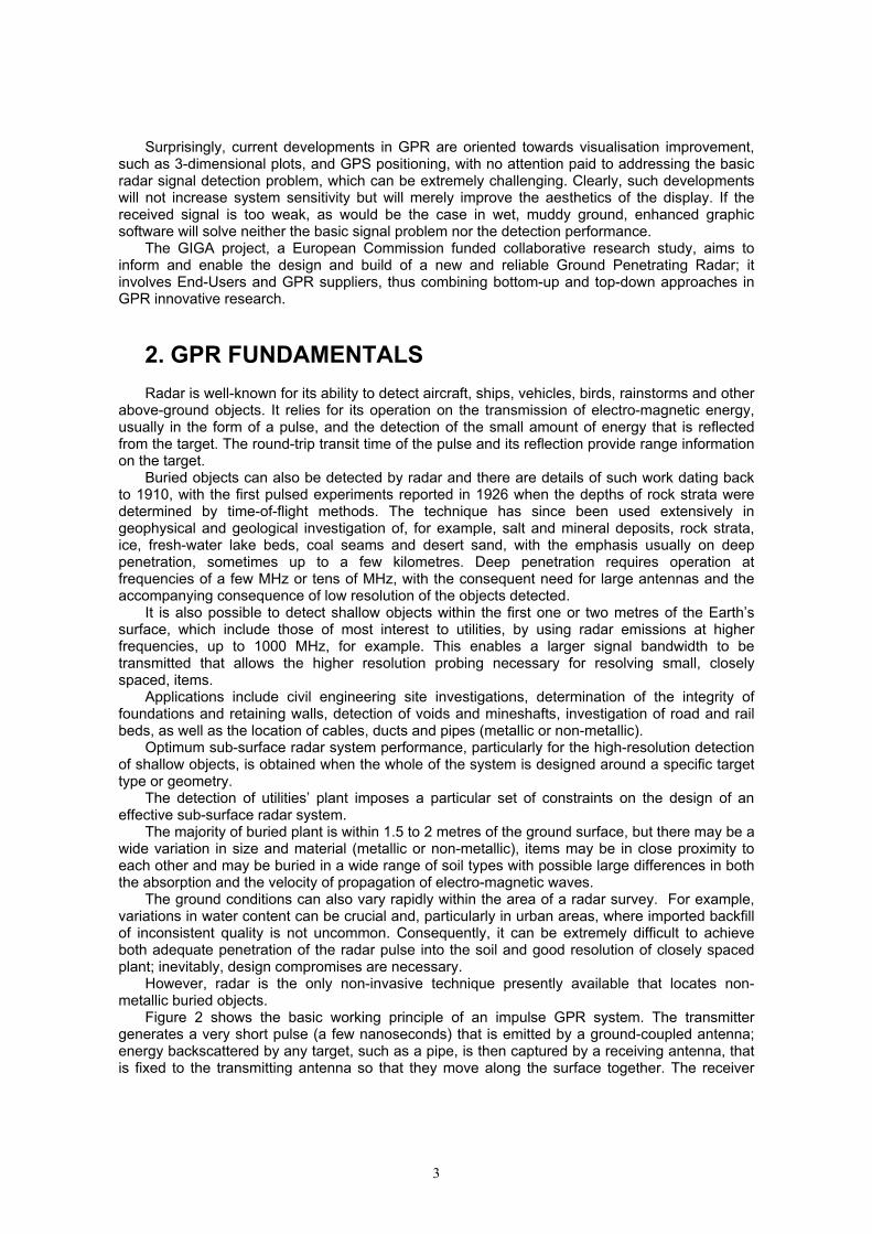
Figure 2 shows the basic working principle of an impulse GPR system. The transmitter generates a very short pulse (a few nanoseconds) that is emitted by a ground-coupled antenna; energy backscattered by any target, such as a pipe, is then captured by a receiving antenna, that is fixed to the transmitting antenna so that they move along the surface together. The receiver
4
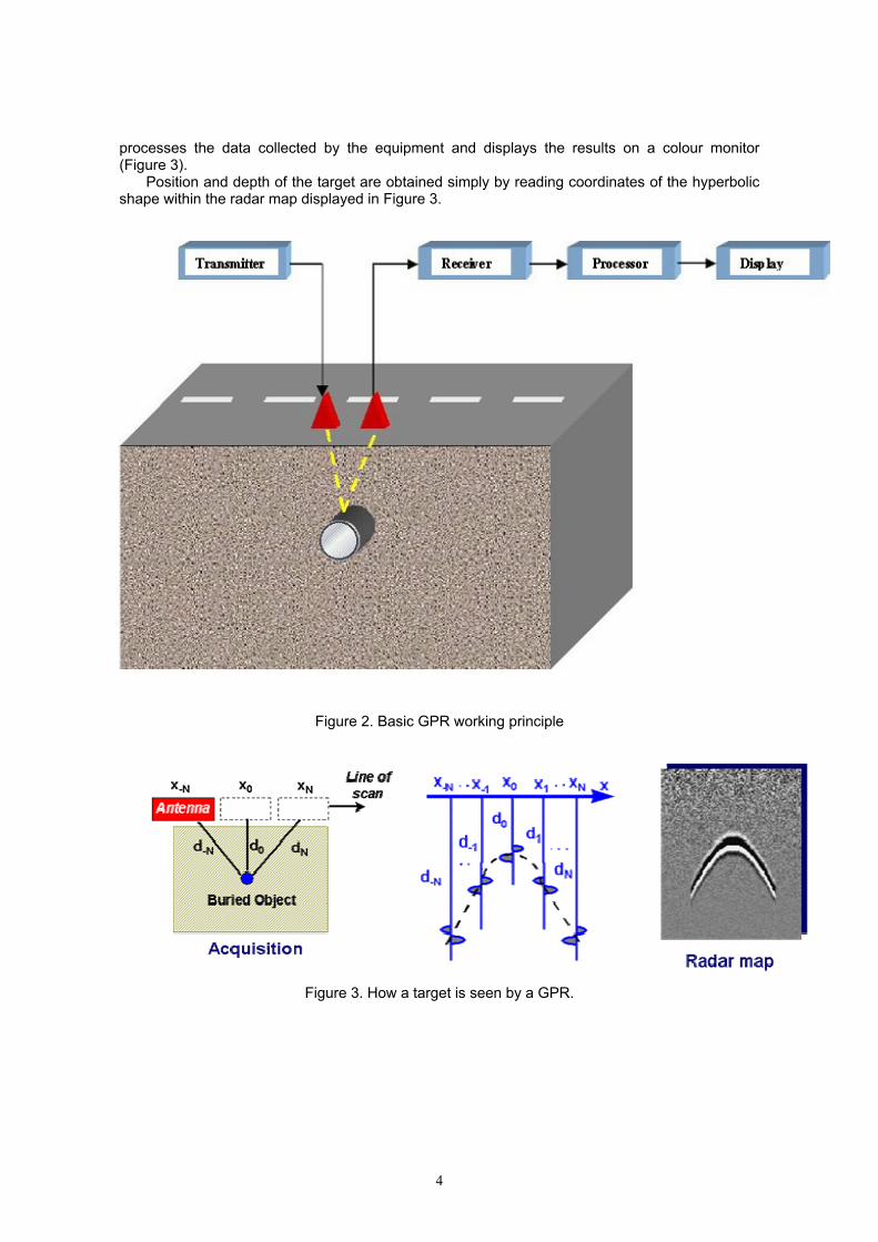
processes the data collected by the equipment and displays the results on a colour monitor (Figure 3).
Position and depth of the target are obtained simply by reading coordinates of the hyperbolic shape within the radar map displayed in Figure 3.
Figure 2. Basic GPR working principle
Figure 3. How a target is seen by a GPR.
5
3. THE GIGA PROJECT The GIGA (Ground Penetrating Radar Innovative research for highly reliable
robustness/accuracy Gas pipe detection/location) project was a European Commission funded collaborative research study to inform and enable the design and build of a new and reliable Ground Penetrating Radar (GPR). Its duration was 2 years and it was completed in December 2003. The overall objective was to design a GPR with a detection performance significantly improved compared to the present generation of equipment, and robust enough to be used with confidence on diverse types of pipes buried in diverse types of soils.
GIGA assembled a multidisciplinary team of GPR designers, developers, service providers and End-Users to take a fresh look at GPR development. Their combined knowledge and experience has enabled a user-led evaluation of the project and a consequent high level of confidence in the results.
This innovative approach has comprised four main activities:
• a meticulous assessment of the performance of a state-of-the-art GPR in surveys conducted under controlled conditions at dedicated test sites;
• radar technology improvements, including multi-parameter/variable configuration of the radar;
• development of new simulation tools to enable a fresh, theoretical view of the problem to form the basis of an improved equipment design;
• development of software processing tools to reduce the need for highly trained operators.
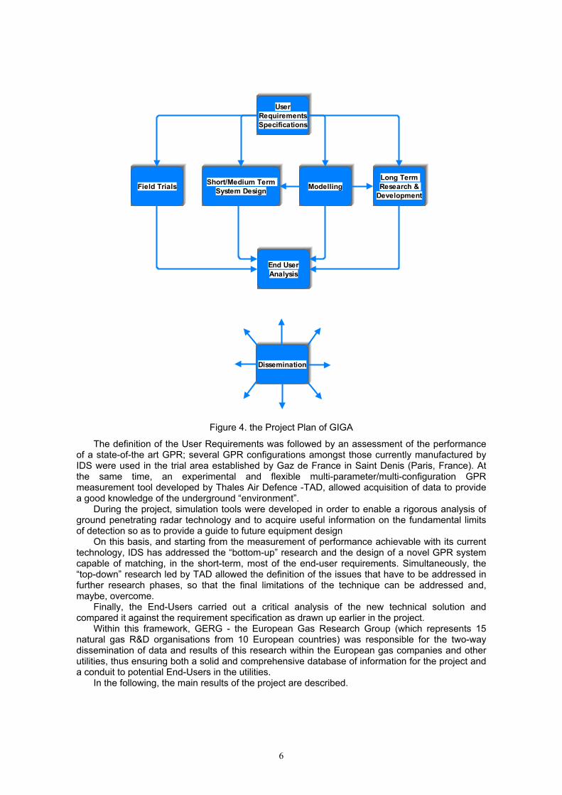
The project’s work plan is shown in Figure 4; an important feature was key role played by the End-Users who were responsible for establishing the requirements and analysing the results achieved within the project.
The outcome and conclusions of the project were considerably strengthened by the involvement of the End-Users (led by Gaz de France, Tracto-Technik (TT Group) and OSYS Technology) in collecting, formulating and evaluating the requirements specification of the European utilities (gas, water, telecom, electricity, etc.). The resulting Requirements Specification was a key project document that guided the research activities.
6
UserRequirementsSpecifications
Field Trials Short/Medium Term System Design Modelling
Long Term Research &
Development
End UserAnalysis
Dissemination
Figure 4. the Project Plan of GIGA
The definition of the User Requirements was followed by an assessment of the performance of a state-of-the art GPR; several GPR configurations amongst those currently manufactured by IDS were used in the trial area established by Gaz de France in Saint Denis (Paris, France). At the same time, an experimental and flexible multi-parameter/multi-configuration GPR measurement tool developed by Thales Air Defence -TAD, allowed acquisition of data to provide a good knowledge of the underground “environment”.
During the project, simulation tools were developed in order to enable a rigorous analysis of ground penetrating radar technology and to acquire useful information on the fundamental limits of detection so as to provide a guide to future equipment design
On this basis, and starting from the measurement of performance achievable with its current technology, IDS has addressed the “bottom-up” research and the design of a novel GPR system capable of matching, in the short-term, most of the end-user requirements. Simultaneously, the “top-down” research led by TAD allowed the definition of the issues that have to be addressed in further research phases, so that the final limitations of the technique can be addressed and, maybe, overcome.
Finally, the End-Users carried out a critical analysis of the new technical solution and compared it against the requirement specification as drawn up earlier in the project.
Within this framework, GERG - the European Gas Research Group (which represents 15 natural gas R&D organisations from 10 European countries) was responsible for the two-way dissemination of data and results of this research within the European gas companies and other utilities, thus ensuring both a solid and comprehensive database of information for the project and a conduit to potential End-Users in the utilities.
In the following, the main results of the project are described.
7
4. FIELD TRIALS Ideally, a pipe location system should have the capability to detect and map all classes of
buried pipes and cables. For the system to be accepted by users as reliable, it must have a good depth of penetration within which there must also be a low rate of failure to detect real buried objects and a low rate of false target generation.
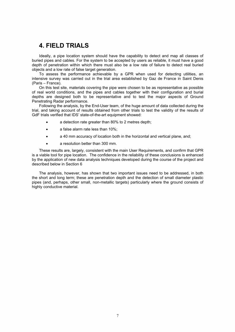
To assess the performance achievable by a GPR when used for detecting utilities, an intensive survey was carried out in the trial area established by Gaz de France in Saint Denis (Paris – France).
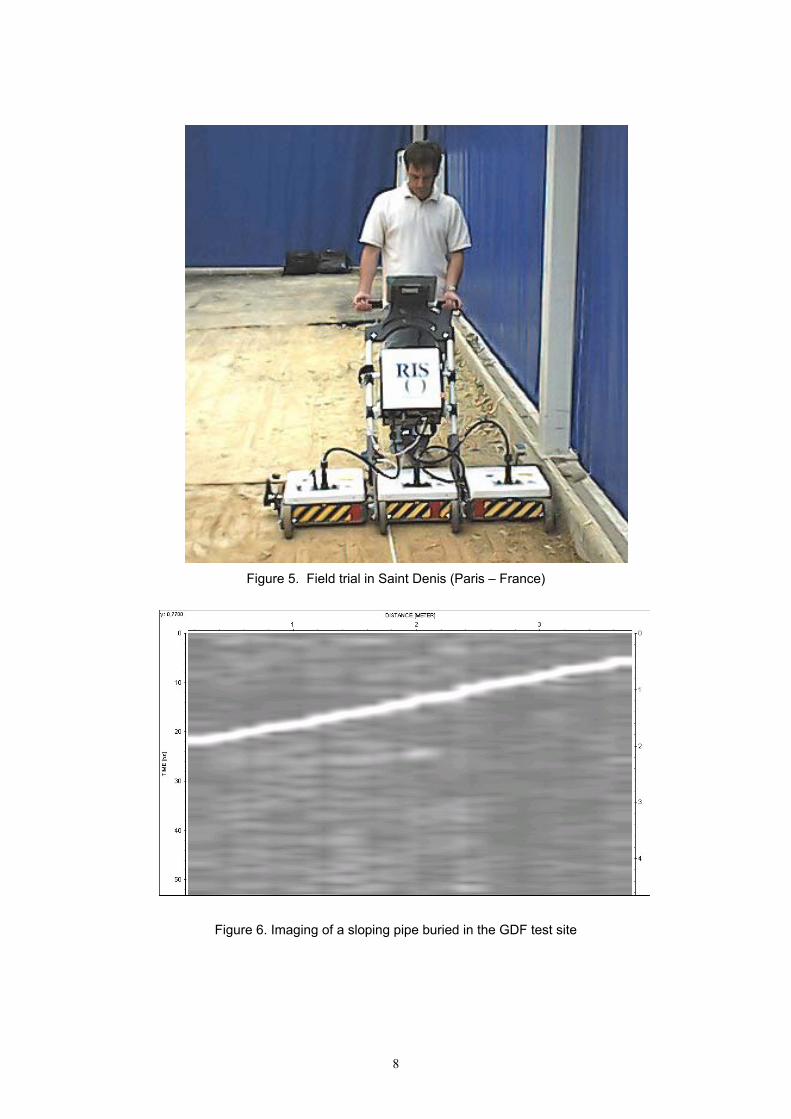
On this test site, materials covering the pipe were chosen to be as representative as possible of real world conditions, and the pipes and cables together with their configuration and burial depths are designed both to be representative and to test the major aspects of Ground Penetrating Radar performance.
Following the analysis, by the End-User team, of the huge amount of data collected during the trial, and taking account of results obtained from other trials to test the validity of the results of GdF trials verified that IDS’ state-of-the-art equipment showed:
• a detection rate greater than 80% to 2 metres depth;
• a false alarm rate less than 10%;
• a 40 mm accuracy of location both in the horizontal and vertical plane, and;
• a resolution better than 300 mm.
These results are, largely, consistent with the main User Requirements, and confirm that GPR is a viable tool for pipe location. The confidence in the reliability of these conclusions is enhanced by the application of new data analysis techniques developed during the course of the project and described below in Section 6
The analysis, however, has shown that two important issues need to be addressed, in both
the short and long term; these are penetration depth and the detection of small diameter plastic pipes (and, perhaps, other small, non-metallic targets) particularly where the ground consists of highly conductive material.
8
Figure 5. Field trial in Saint Denis (Paris – France)
Figure 6. Imaging of a sloping pipe buried in the GDF test site
9
5. MODELLING During the GIGA project, simulation tools capable of modelling the electrical behaviour of
buried targets and their environment were developed. In particular, two different tools were utilised during the project. The first uses the
Transmission Line Matrix (TLM) method for reproducing typical GPR scenarios by working in time-domain; the second uses an approximation based upon optical propagation laws and ray tracing rather than solving Maxwell’s equations. This latter method is very economical in processing time, it cannot, however, be used for analysing complex scenarios.
Only the TLM method will be described here. 5.1 THE TLM METHOD
The transmission line matrix method is a relatively new development in computational
electromagnetism. It is a powerful, general-purpose tool for modelling a wide range of electromagnetic problems. The TLM technique can model lossy dielectric materials and those with finite conductivity. Features such as thin wires and layers of thin material layers can also be modelled.
For that reason, the technique was tested for modelling GPR scenarios, including complex geometries and frequency dependent material properties, as well as GPR antennas.
The modelling of structures is performed by discretising the problem space into a number of cells on a Cartesian grid. These cells may vary in size to provide graded volumetric meshing for arbitrary shapes and structures. In this way, the problems with modelling areas of fine detail are largely eliminated (though it still is a staircase approximation to the geometry).
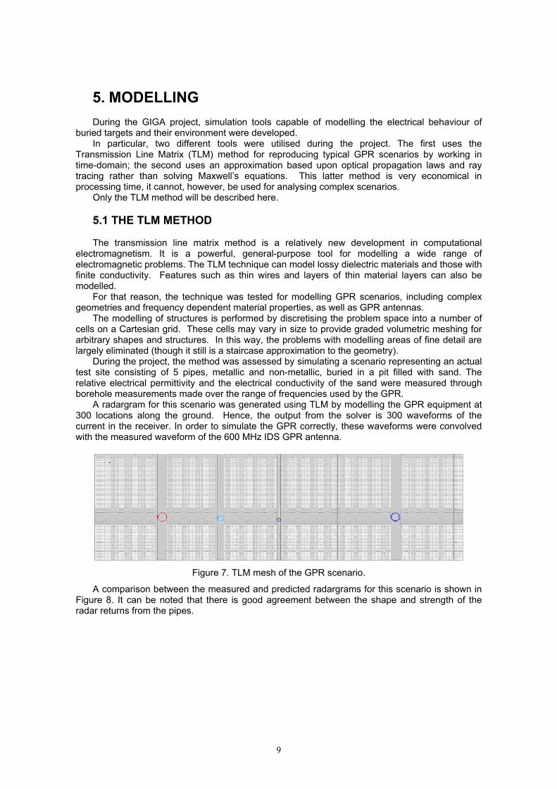
During the project, the method was assessed by simulating a scenario representing an actual test site consisting of 5 pipes, metallic and non-metallic, buried in a pit filled with sand. The relative electrical permittivity and the electrical conductivity of the sand were measured through borehole measurements made over the range of frequencies used by the GPR.
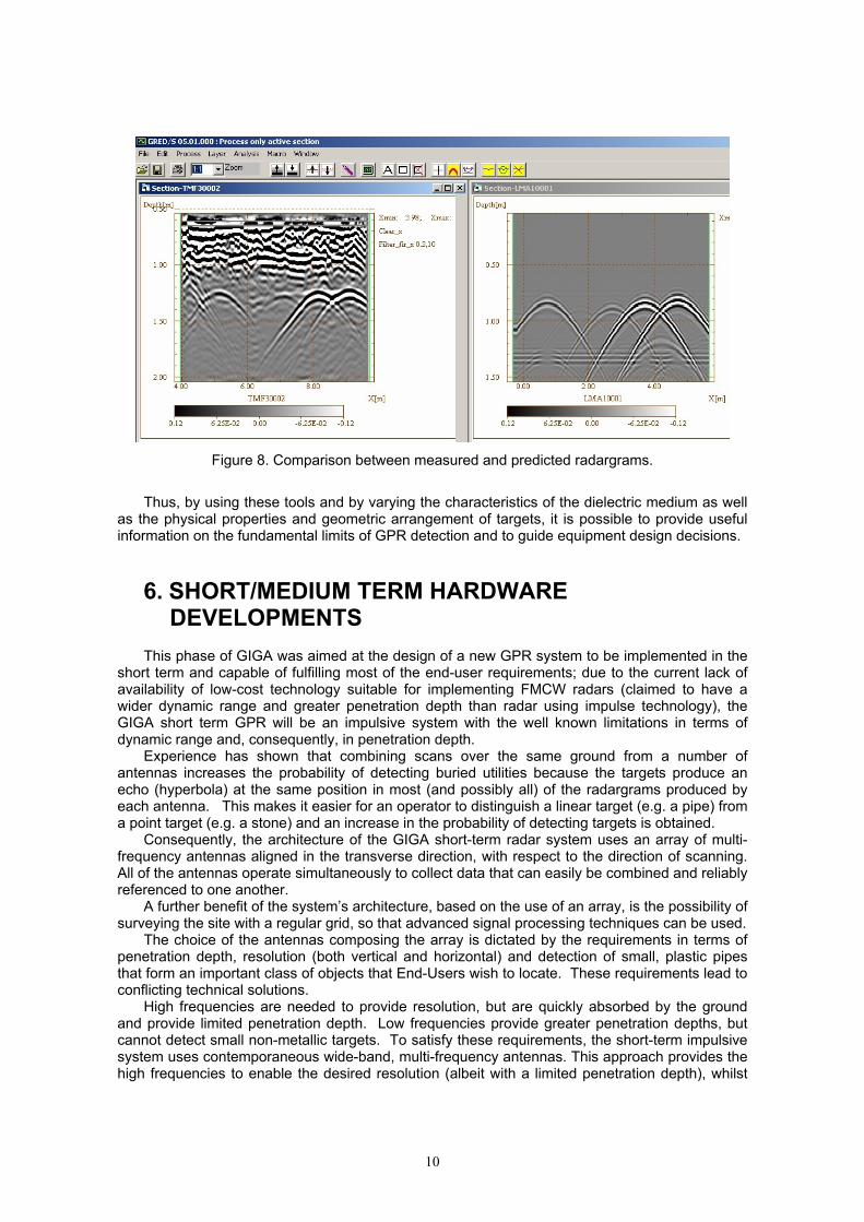
A radargram for this scenario was generated using TLM by modelling the GPR equipment at 300 locations along the ground. Hence, the output from the solver is 300 waveforms of the current in the receiver. In order to simulate the GPR correctly, these waveforms were convolved with the measured waveform of the 600 MHz IDS GPR antenna.
Figure 7. TLM mesh of the GPR scenario.
A comparison between the measured and predicted radargrams for this scenario is shown in Figure 8. It can be noted that there is good agreement between the shape and strength of the radar returns from the pipes.
10
Figure 8. Comparison between measured and predicted radargrams.
Thus, by using these tools and by varying the characteristics of the dielectric medium as well
as the physical properties and geometric arrangement of targets, it is possible to provide useful information on the fundamental limits of GPR detection and to guide equipment design decisions.
6. SHORT/MEDIUM TERM HARDWARE DEVELOPMENTS
This phase of GIGA was aimed at the design of a new GPR system to be implemented in the
short term and capable of fulfilling most of the end-user requirements; due to the current lack of availability of low-cost technology suitable for implementing FMCW radars (claimed to have a wider dynamic range and greater penetration depth than radar using impulse technology), the GIGA short term GPR will be an impulsive system with the well known limitations in terms of dynamic range and, consequently, in penetration depth.
Experience has shown that combining scans over the same ground from a number of antennas increases the probability of detecting buried utilities because the targets produce an echo (hyperbola) at the same position in most (and possibly all) of the radargrams produced by each antenna. This makes it easier for an operator to distinguish a linear target (e.g. a pipe) from a point target (e.g. a stone) and an increase in the probability of detecting targets is obtained.
Consequently, the architecture of the GIGA short-term radar system uses an array of multi-frequency antennas aligned in the transverse direction, with respect to the direction of scanning. All of the antennas operate simultaneously to collect data that can easily be combined and reliably referenced to one another.
A further benefit of the system’s architecture, based on the use of an array, is the possibility of surveying the site with a regular grid, so that advanced signal processing techniques can be used.
The choice of the antennas composing the array is dictated by the requirements in terms of penetration depth, resolution (both vertical and horizontal) and detection of small, plastic pipes that form an important class of objects that End-Users wish to locate. These requirements lead to conflicting technical solutions.
High frequencies are needed to provide resolution, but are quickly absorbed by the ground and provide limited penetration depth. Low frequencies provide greater penetration depths, but cannot detect small non-metallic targets. To satisfy these requirements, the short-term impulsive system uses contemporaneous wide-band, multi-frequency antennas. This approach provides the high frequencies to enable the desired resolution (albeit with a limited penetration depth), whilst
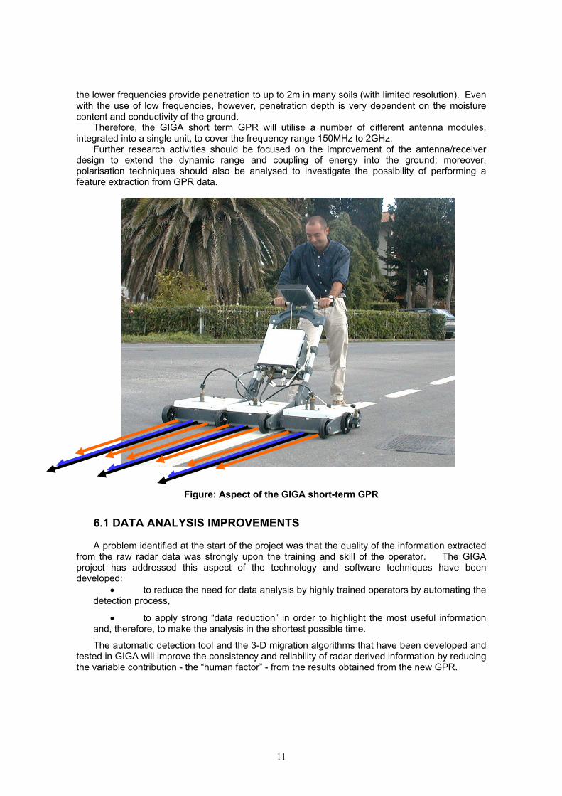
11
the lower frequencies provide penetration to up to 2m in many soils (with limited resolution). Even with the use of low frequencies, however, penetration depth is very dependent on the moisture content and conductivity of the ground.
Therefore, the GIGA short term GPR will utilise a number of different antenna modules, integrated into a single unit, to cover the frequency range 150MHz to 2GHz.
Further research activities should be focused on the improvement of the antenna/receiver design to extend the dynamic range and coupling of energy into the ground; moreover, polarisation techniques should also be analysed to investigate the possibility of performing a feature extraction from GPR data.
Figure: Aspect of the GIGA short-term GPR
6.1 DATA ANALYSIS IMPROVEMENTS A problem identified at the start of the project was that the quality of the information extracted
from the raw radar data was strongly upon the training and skill of the operator. The GIGA project has addressed this aspect of the technology and software techniques have been developed:
• to reduce the need for data analysis by highly trained operators by automating the detection process,
• to apply strong “data reduction” in order to highlight the most useful information and, therefore, to make the analysis in the shortest possible time.
The automatic detection tool and the 3-D migration algorithms that have been developed and tested in GIGA will improve the consistency and reliability of radar derived information by reducing the variable contribution - the “human factor” - from the results obtained from the new GPR.
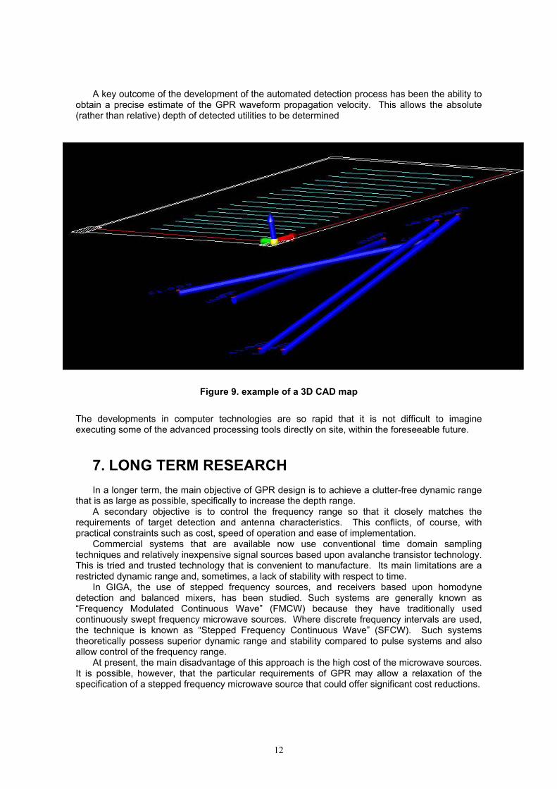
12
A key outcome of the development of the automated detection process has been the ability to obtain a precise estimate of the GPR waveform propagation velocity. This allows the absolute (rather than relative) depth of detected utilities to be determined
Figure 9. example of a 3D CAD map
The developments in computer technologies are so rapid that it is not difficult to imagine executing some of the advanced processing tools directly on site, within the foreseeable future.
7. LONG TERM RESEARCH
In a longer term, the main objective of GPR design is to achieve a clutter-free dynamic range that is as large as possible, specifically to increase the depth range.
A secondary objective is to control the frequency range so that it closely matches the requirements of target detection and antenna characteristics. This conflicts, of course, with practical constraints such as cost, speed of operation and ease of implementation.
Commercial systems that are available now use conventional time domain sampling techniques and relatively inexpensive signal sources based upon avalanche transistor technology. This is tried and trusted technology that is convenient to manufacture. Its main limitations are a restricted dynamic range and, sometimes, a lack of stability with respect to time.
In GIGA, the use of stepped frequency sources, and receivers based upon homodyne detection and balanced mixers, has been studied. Such systems are generally known as “Frequency Modulated Continuous Wave” (FMCW) because they have traditionally used continuously swept frequency microwave sources. Where discrete frequency intervals are used, the technique is known as “Stepped Frequency Continuous Wave” (SFCW). Such systems theoretically possess superior dynamic range and stability compared to pulse systems and also allow control of the frequency range.
At present, the main disadvantage of this approach is the high cost of the microwave sources. It is possible, however, that the particular requirements of GPR may allow a relaxation of the specification of a stepped frequency microwave source that could offer significant cost reductions.
13
The output of FMCW systems is, by definition, in the frequency domain, thus necessitating a transformation into the time domain in order to extract target and range information. This is most often carried out using Fourier Transformations and the resulting output of this process is equivalent to that of a time domain sampling system with much wider dynamic range and stability.
Thus, in the longer term, it seems reasonable to assert that a Stepped Frequency Continuous Wave GPR will constitute a further step to addressing and possibly overcoming the remaining limitations of the technique.
8. CONCLUSIONS
GIGA was a research study, which was established to inform and enable the design and build of a new, dependable Ground Probing Radar (GPR). Its long term objective was a GPR specifically designed to provide the precision, high resolution, and consistency and reliability of results required to increase the use of No-Dig techniques for the installation of buried utilities. Because more consistent and reliable information on the location of legacy infrastructure reduces the probability of damage and injury to personnel when installing new plant, the use of techniques such as Horizontal Directional Drilling (HDD) will increase. This will lead to economic benefits and contribute to the better protection of the environment and ensure a better quality of life for citizens.
On the assumption that an improved GPR will be available, GIGA has estimated the potential for a reduction in the cost of installing gas pipelines and telecommunications networks. In addition, there is potential for further investment cost saving by using trenchless directional drilling, in association with GPR, when compared with classical trench digging, and the possibility of considerable social, environmental and quality of life benefits from reductions in streetworks..
GIGA’s innovative approach came from the assessment of range depth, detection rate and accuracy required both by HDD operators and utility companies, and from research activities by following both top-down and bottom-up methodologies.
Over the two-year course of the project, valuable results were obtained; amongst them, a meticulous assessment of the performance achievable by a GPR at the “state-of-the-art” and the important issues that need to be addressed, in both the short and long term; these are penetration depth and the detection of small diameter plastic pipes (and, perhaps, other small, non-metallic targets) particularly when deeper than 0.5 m and where the ground consists of material that is highly conductive.
The design of a new GPR equipment that will be capable of satisfying, in the short term, most of the End-user requirements has been proposed; by using multi-frequency antennas, such a system is believed to be suitable for extending the penetration depth to more than two metres in most circumstances.
In the longer term, it is likely that a Stepped Frequency Continuous Wave system could allow optimal frequency adaptation to the environment, providing further performance improvements in terms of penetration depth and the range of soil types and conditions in which GPR can operate.
Indeed, these encouraging results mean that GIGA will be followed by a second, medium-long term project to design, develop and test a new, specific GPR demonstration prototype.
ACKNOWLEDGMENTS
The GIGA project is partly supported by the European Commission‘s 5th Framework Program for Community Research, Energy, Environment and Sustainable Development, managed by Directorate General for Research under the contract N° ENK6-CT-2001-00506 and would not have been possible without the support of the Commission.
The authors are grateful to Mr. Georges-Edouard Michel (Thales Air Defence) for his contribution to this paper