Embed Size (px)
Citation preview
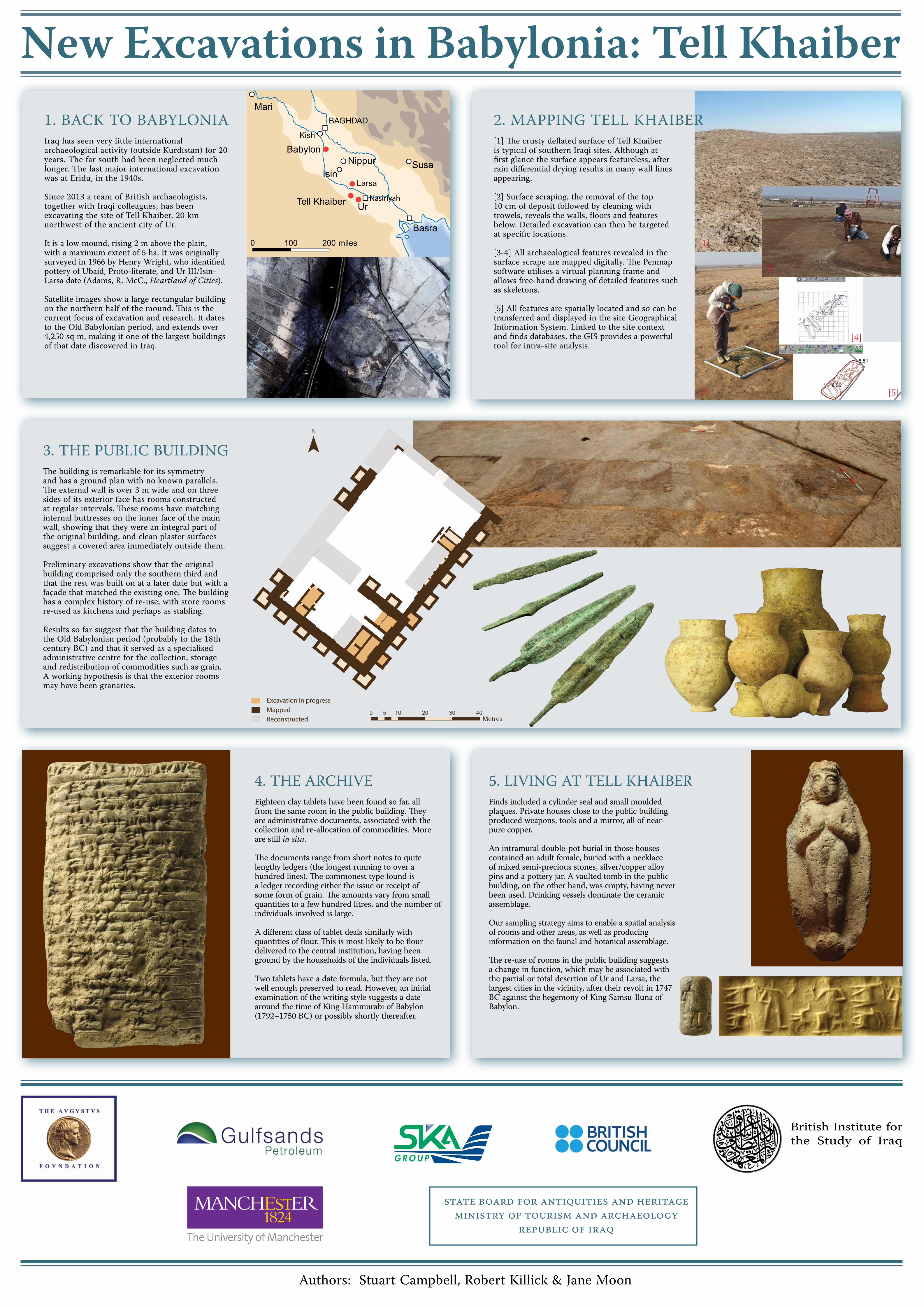
1. BACK TO BABYLONIAIraq has seen very little international archaeological activity (outside Kurdistan) for 20 years. The far south had been neglected much longer. The last major international excavation was at Eridu, in the 1940s.
Since 2013 a team of British archaeologists, together with Iraqi colleagues, has been excavating the site of Tell Khaiber, 20 km northwest of the ancient city of Ur.
It is a low mound, rising 2 m above the plain, with a maximum extent of 5 ha. It was originally surveyed in 1966 by Henry Wright, who identified pottery of Ubaid, Proto-literate, and Ur III/Isin-Larsa date (Adams, R. McC., Heartland of Cities).
Satellite images show a large rectangular building on the northern half of the mound. This is the current focus of excavation and research. It dates to the Old Babylonian period, and extends over 4,250 sq m, making it one of the largest buildings of that date discovered in Iraq.
3. THE PUBLIC BUILDINGThe building is remarkable for its symmetry and has a ground plan with no known parallels. The external wall is over 3 m wide and on three sides of its exterior face has rooms constructed at regular intervals. These rooms have matching internal buttresses on the inner face of the main wall, showing that they were an integral part of the original building, and clean plaster surfaces suggest a covered area immediately outside them.
Preliminary excavations show that the original building comprised only the southern third and that the rest was built on at a later date but with a façade that matched the existing one. The building has a complex history of re-use, with store rooms re-used as kitchens and perhaps as stabling.
Results so far suggest that the building dates to the Old Babylonian period (probably to the 18th century BC) and that it served as a specialised administrative centre for the collection, storage and redistribution of commodities such as grain. A working hypothesis is that the exterior rooms may have been granaries.
New Excavations in Babylonia: Tell Khaiber
Larsa
Kish
miles
Nasiriyah
[1]
[2]
[3]
2. MAPPING TELL KHAIBER[1] The crusty deflated surface of Tell Khaiber is typical of southern Iraqi sites. Although at first glance the surface appears featureless, after rain differential drying results in many wall lines appearing.
[2] Surface scraping, the removal of the top 10 cm of deposit followed by cleaning with trowels, reveals the walls, floors and features below. Detailed excavation can then be targeted at specific locations.
[3-4] All archaeological features revealed in the surface scrape are mapped digitally. The Penmap software utilises a virtual planning frame and allows free-hand drawing of detailed features such as skeletons.
[5] All features are spatially located and so can be transferred and displayed in the site Geographical Information System. Linked to the site context and finds databases, the GIS provides a powerful tool for intra-site analysis.
[4]
British Institute for the Study of Iraq
State Board for antiquitieS and HeritageMiniStry of touriSM and arcHaeology
repuBlic of iraq
4. THE ARCHIVEEighteen clay tablets have been found so far, all from the same room in the public building. They are administrative documents, associated with the collection and re-allocation of commodities. More are still in situ.
The documents range from short notes to quite lengthy ledgers (the longest running to over a hundred lines). The commonest type found is a ledger recording either the issue or receipt of some form of grain. The amounts vary from small quantities to a few hundred litres, and the number of individuals involved is large.
A different class of tablet deals similarly with quantities of flour. This is most likely to be flour delivered to the central institution, having been ground by the households of the individuals listed.
Two tablets have a date formula, but they are not well enough preserved to read. However, an initial examination of the writing style suggests a date around the time of King Hammurabi of Babylon (1792–1750 BC) or possibly shortly thereafter.
5. LIVING AT TELL KHAIBERFinds included a cylinder seal and small moulded plaques. Private houses close to the public building produced weapons, tools and a mirror, all of near-pure copper.
An intramural double-pot burial in those houses contained an adult female, buried with a necklace of mixed semi-precious stones, silver/copper alloy pins and a pottery jar. A vaulted tomb in the public building, on the other hand, was empty, having never been used. Drinking vessels dominate the ceramic assemblage.
Our sampling strategy aims to enable a spatial analysis of rooms and other areas, as well as producing information on the faunal and botanical assemblage.
The re-use of rooms in the public building suggests a change in function, which may be associated with the partial or total desertion of Ur and Larsa, the largest cities in the vicinity, after their revolt in 1747 BC against the hegemony of King Samsu-Iluna of Babylon.
[5]
0 10 20 30 405Metres
¯
MappedReconstructed
Excavation in progress
Authors: Stuart Campbell, Robert Killick & Jane Moon
![The Religion of Babylonia and Assyria · The Religion of Babylonia and Assyria by Theophilus G. Pinches February, 2000 [Etext #2069] The Project Gutenberg Etext The Religion of Babylonia](https://img.pdfslide.us/doc/110x75/5f6e5b34eacf7332d0023a2a/the-religion-of-babylonia-and-assyria-the-religion-of-babylonia-and-assyria-by-theophilus.jpg)