Embed Size (px)
Citation preview
13th World Conference on Earthquake Engineering Vancouver, B.C., Canada
August 1-6, 2004 Paper No. 2189
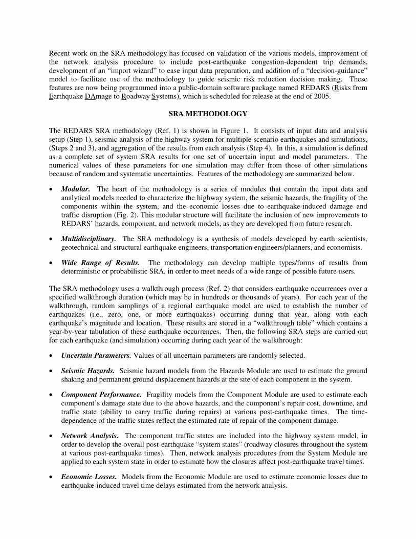
NEW DEVELOPMENTS IN SEISMIC RISK ANALYSIS OF HIGHWAY SYSTEMS
Stuart D. WERNER 1, Craig E. TAYLOR2, Sungbin CHO3, Jean-Paul LAVOIE4, Charles K. HUYCK3, Chip EITZEL4, Ronald T. EGUCHI3, and James E. MOORE II5
SUMMARY A new methodology has been developed for probabilistic or deterministic seismic risk analysis (SRA) of highway systems. This methodology is multidisciplinary and modular, and includes new and improved procedures and models for scenario earthquakes, seismic hazards, bridge fragility, and transportation network analysis. It has been applied to actual highway systems in the United States, and is now being programmed into a public-domain software package named REDARS 2. This paper summarizes the technical features of the SRA methodology, its application to the Shelby County, Tennessee highway system, and recent improvements to the methodology and its models. Future research directions to further develop the methodology are also discussed.
INTRODUCTION Over the past several years, the United States Federal Highway Administration (FHWA) has been sponsoring a multi-year research project titled “Seismic Vulnerability of the Highway System”, which is being carried out through the Multidisciplinary Center for Earthquake Engineering Research (MCEER). This project includes a task to enhance current procedures for seismic risk analysis (SRA) of highway systems, and to program these enhancements into a public domain software package named REDARS 2. Early efforts under this task included: (a) development of the framework of the SRA methodology; and (b) initial deterministic application of the methodology to the highway-roadway network in Shelby County, Tennessee using then-available models, in order to demonstrate the use of the methodology and to prioritize further research under the FHWA-MCEER project. This research led to improved models for scenario earthquakes, seismic hazards, bridge fragility, and transportation network analysis. These updated models were then used to carry out a fully probabilistic SRA of the Shelby County roadway network. This probabilistic SRA application is summarized later in this paper.
1 Seismic Systems & Engineering Consultants, Oakland CA, USA. E-Mail: [email protected] 2 Natural Hazards Management Inc., Torrance CA., USA 3 ImageCat Inc., Long Beach CA, USA 4 Geodesy, San Francisco CA, USA 5 University of Southern California, Los Angeles CA, USA
Recent work on the SRA methodology has focused on validation of the various models, improvement of the network analysis procedure to include post-earthquake congestion-dependent trip demands, development of an “import wizard” to ease input data preparation, and addition of a “decision-guidance” model to facilitate use of the methodology to guide seismic risk reduction decision making. These features are now being programmed into a public-domain software package named REDARS (Risks from Earthquake DAmage to Roadway Systems), which is scheduled for release at the end of 2005.
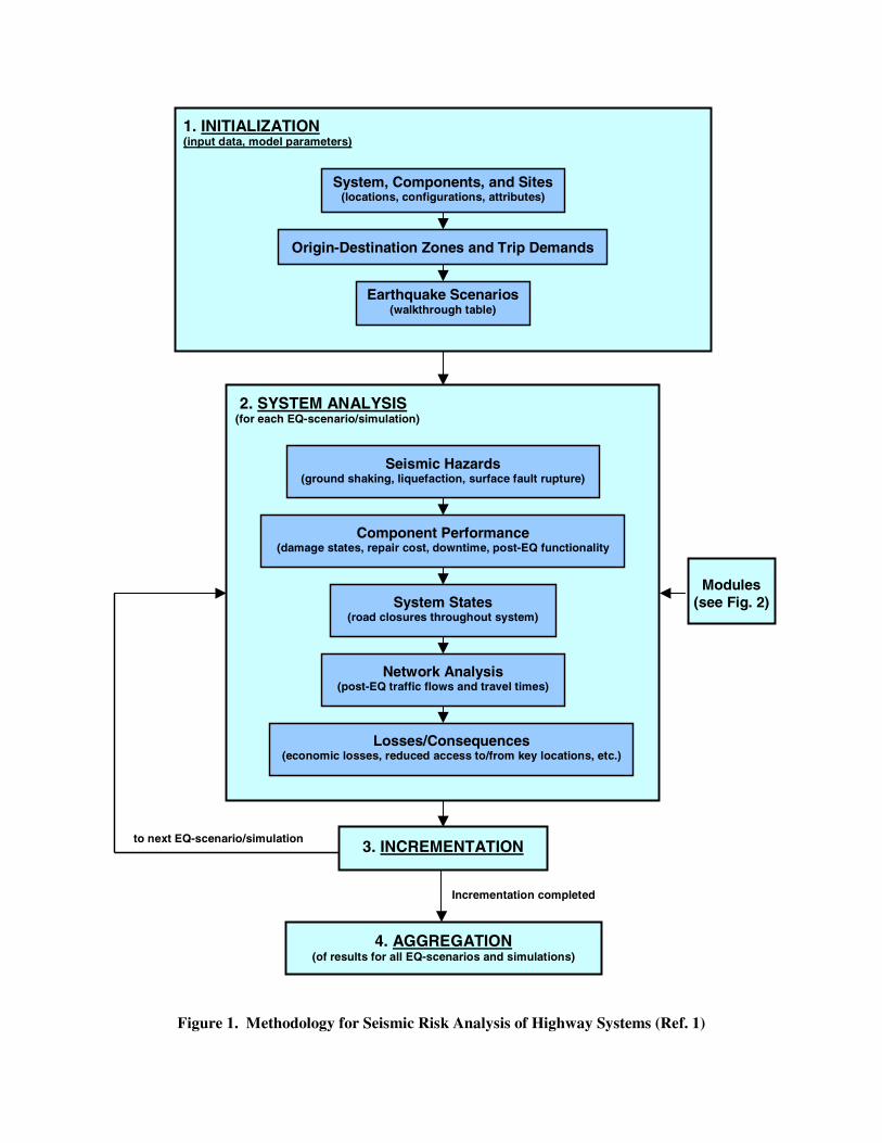
SRA METHODOLOGY The REDARS SRA methodology (Ref. 1) is shown in Figure 1. It consists of input data and analysis setup (Step 1), seismic analysis of the highway system for multiple scenario earthquakes and simulations, (Steps 2 and 3), and aggregation of the results from each analysis (Step 4). In this, a simulation is defined as a complete set of system SRA results for one set of uncertain input and model parameters. The numerical values of these parameters for one simulation may differ from those of other simulations because of random and systematic uncertainties. Features of the methodology are summarized below.
• Modular. The heart of the methodology is a series of modules that contain the input data and analytical models needed to characterize the highway system, the seismic hazards, the fragility of the components within the system, and the economic losses due to earthquake-induced damage and traffic disruption (Fig. 2). This modular structure will facilitate the inclusion of new improvements to REDARS’ hazards, component, and network models, as they are developed from future research.
• Multidisciplinary. The SRA methodology is a synthesis of models developed by earth scientists, geotechnical and structural earthquake engineers, transportation engineers/planners, and economists.
• Wide Range of Results. The methodology can develop multiple types/forms of results from deterministic or probabilistic SRA, in order to meet needs of a wide range of possible future users.
The SRA methodology uses a walkthrough process (Ref. 2) that considers earthquake occurrences over a specified walkthrough duration (which may be in hundreds or thousands of years). For each year of the walkthrough, random samplings of a regional earthquake model are used to establish the number of earthquakes (i.e., zero, one, or more earthquakes) occurring during that year, along with each earthquake’s magnitude and location. These results are stored in a “walkthrough table” which contains a year-by-year tabulation of these earthquake occurrences. Then, the following SRA steps are carried out for each earthquake (and simulation) occurring during each year of the walkthrough:
• Uncertain Parameters. Values of all uncertain parameters are randomly selected.
• Seismic Hazards. Seismic hazard models from the Hazards Module are used to estimate the ground shaking and permanent ground displacement hazards at the site of each component in the system.
• Component Performance. Fragility models from the Component Module are used to estimate each component’s damage state due to the above hazards, and the component’s repair cost, downtime, and traffic state (ability to carry traffic during repairs) at various post-earthquake times. The time-dependence of the traffic states reflect the estimated rate of repair of the component damage.
• Network Analysis. The component traffic states are included into the highway system model, in order to develop the overall post-earthquake “system states” (roadway closures throughout the system at various post-earthquake times). Then, network analysis procedures from the System Module are applied to each system state in order to estimate how the closures affect post-earthquake travel times.
• Economic Losses. Models from the Economic Module are used to estimate economic losses due to earthquake-induced travel time delays estimated from the network analysis.
System, Components, and Sites (locations, configurations, attributes)
1. INITIALIZATION (input data, model parameters)
Origin-Destination Zones and Trip Demands
Earthquake Scenarios (walkthrough table)
2. SYSTEM ANALYSIS (for each EQ-scenario/simulation)
Modules (see Fig. 2)
Seismic Hazards (ground shaking, liquefaction, surface fault rupture)
Component Performance (damage states, repair cost, downtime, post-EQ functionality
System States (road closures throughout system)
Network Analysis (post-EQ traffic flows and travel times)
Losses/Consequences (economic losses, reduced access to/from key locations, etc.)
3. INCREMENTATION
4. AGGREGATION (of results for all EQ-scenarios and simulations)
Figure 1. Methodology for Seismic Risk Analysis of Highway Systems (Ref. 1)
to next EQ-scenario/simulation
Incrementation completed
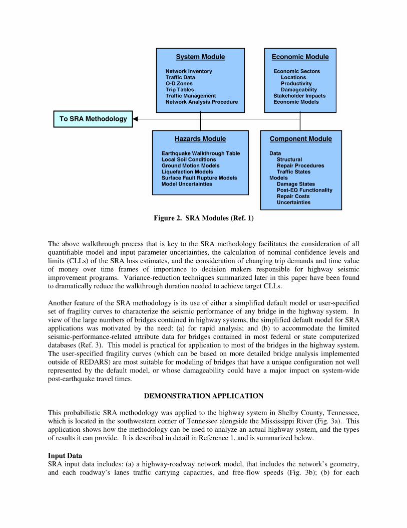
Figure 2. SRA Modules (Ref. 1) The above walkthrough process that is key to the SRA methodology facilitates the consideration of all quantifiable model and input parameter uncertainties, the calculation of nominal confidence levels and limits (CLLs) of the SRA loss estimates, and the consideration of changing trip demands and time value of money over time frames of importance to decision makers responsible for highway seismic improvement programs. Variance-reduction techniques summarized later in this paper have been found to dramatically reduce the walkthrough duration needed to achieve target CLLs. Another feature of the SRA methodology is its use of either a simplified default model or user-specified set of fragility curves to characterize the seismic performance of any bridge in the highway system. In view of the large numbers of bridges contained in highway systems, the simplified default model for SRA applications was motivated by the need: (a) for rapid analysis; and (b) to accommodate the limited seismic-performance-related attribute data for bridges contained in most federal or state computerized databases (Ref. 3). This model is practical for application to most of the bridges in the highway system. The user-specified fragility curves (which can be based on more detailed bridge analysis implemented outside of REDARS) are most suitable for modeling of bridges that have a unique configuration not well represented by the default model, or whose damageability could have a major impact on system-wide post-earthquake travel times.
DEMONSTRATION APPLICATION This probabilistic SRA methodology was applied to the highway system in Shelby County, Tennessee, which is located in the southwestern corner of Tennessee alongside the Mississippi River (Fig. 3a). This application shows how the methodology can be used to analyze an actual highway system, and the types of results it can provide. It is described in detail in Reference 1, and is summarized below. Input Data SRA input data includes: (a) a highway-roadway network model, that includes the network’s geometry, and each roadway’s lanes traffic carrying capacities, and free-flow speeds (Fig. 3b); (b) for each
System Module Network Inventory Traffic Data O-D Zones Trip Tables Traffic Management Network Analysis Procedure
Economic Module Economic Sectors Locations Productivity Damageability Stakeholder Impacts Economic Models
Hazards Module Earthquake Walkthrough Table Local Soil Conditions Ground Motion Models Liquefaction Models Surface Fault Rupture Models Model Uncertainties
Component Module Data Structural Repair Procedures Traffic States Models Damage States Post-EQ Functionality Repair Costs Uncertainties
To SRA Methodology
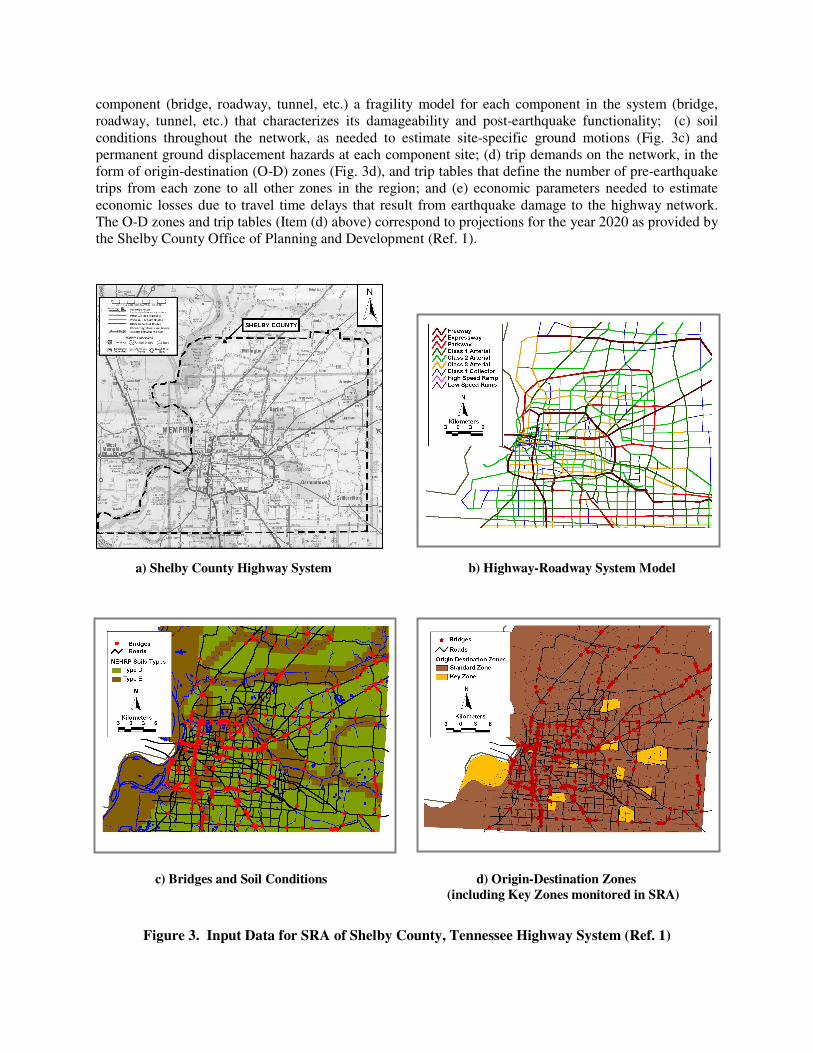
component (bridge, roadway, tunnel, etc.) a fragility model for each component in the system (bridge, roadway, tunnel, etc.) that characterizes its damageability and post-earthquake functionality; (c) soil conditions throughout the network, as needed to estimate site-specific ground motions (Fig. 3c) and permanent ground displacement hazards at each component site; (d) trip demands on the network, in the form of origin-destination (O-D) zones (Fig. 3d), and trip tables that define the number of pre-earthquake trips from each zone to all other zones in the region; and (e) economic parameters needed to estimate economic losses due to travel time delays that result from earthquake damage to the highway network. The O-D zones and trip tables (Item (d) above) correspond to projections for the year 2020 as provided by the Shelby County Office of Planning and Development (Ref. 1).
Figure 3. Input Data for SRA of Shelby County, Tennessee Highway System (Ref. 1)
a) Shelby County Highway System b) Highway-Roadway System Model
c) Bridges and Soil Conditions d) Origin-Destination Zones (including Key Zones monitored in SRA)
Analysis This SRA was conducted by using a walk-through with a duration of 50,000 years. Earthquakes occurring during each year of the walkthrough were estimated by applying the then-current United States Geological Survey models for the Central United States (Ref. 4). This generated 2,321 earthquakes with moment magnitudes ranging from 5.0 to 8.0. The network model included 7,807 links, 15,614 nodes, and 384 bridges. The system analysis for each simulation followed the steps shown in Figure 1. It used a ground shaking model for the Central United States developed by Hwang and Huo (Ref. 5), a liquefaction hazard model developed by Youd (Ref. 6), fragility models for conventional bridges in Shelby County that were developed by Jernigan and Hwang (Ref. 7), special user-specified fragility models for the major crossings of the Mississippi River along Interstate Highways 40 and 55 (Ref. 1), a first-order bridge repair model documented in Reference 1, an approach-fill settlement model by Youd (Ref. 8), and a network analysis procedure developed by Moore et al. that is based on a user-equilibrium model in which pre- and post-earthquake trip demands are assumed to be identical (see Ref. 1). Results The analysis results for any simulation included: (a) GIS displays of region-wide ground shaking and liquefaction hazards, and bridge damage states (Figs 4a-4c); (b) for selected times after the earthquake, GIS displays of post-earthquake system states that reflect the estimated rate of repair of the earthquake damage (Figs. 4d-4f), minimum-time travel paths between any two locations, and traffic volumes along selected roadways; and (c) tabulations of economic losses and effects of earthquake damage on access and egress times to/from selected locations in the region (Table 1). Then, after results from all simulations were aggregated, probabilistic estimates of economic losses for various exposure times were developed (Fig. 5).
NEW DEVELOPMENTS Since the above demonstration application was completed, a validation application of the SRA methodology was carried out and new technological and usability improvements to the methodology were added. These developments are summarized below. Validation Application Prior to developing improvements to the methodology, it was independently reviewed and validated using the early (pre-beta) version the REDARS software that was used to carry out the above demonstration SRA of the Shelby County highway system (Ref. 9). This consisted of: (a) review of the basic SRA methodology; (b) creation of input data for a case study of the Los Angeles area highway system; (c) deterministic predictions of the system’s seismic performance during the Northridge Earthquake, and comparison of these predictions to the system’s observed performance; and (d) performance of sensitivity studies to identify key parameters for loss estimation. The validation focused on the models used to estimate bridge damage states, corresponding traffic states, and post-earthquake travel times. Comparisons of predicted vs. observed seismic performance showed that: (a) the number of damaged bridges was overestimated by a factor of about 2 -- probably because of model simplifications noted earlier in this paper (see bridge research recommendations later in the paper); (b) bridge closure times for a given damage state were overestimated -- which was expected because the bridge repair estimates in this pre-beta REDARS software were intended to simulate Tennessee repair resources, and did not account for the rapid rate of bridge repair after the Northridge Earthquake that resulted from California Department of Transportation repair experience and special repair incentives; and (c) traffic volume predictions for roadways near collapsed bridge sites overestimated observed traffic volumes by factors of 1.3 to 2.5 -- which can be attributed, at least in part, to the ignoring of effects of increased congestion on post-earthquake trip demands in these predictions. These comparisons were incentives for the planning of several of the recent model improvements summarized in the following sections of this paper.
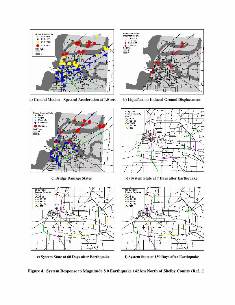
a) Ground Motion – Spectral Acceleration at 1.0 sec. b) Liquefaction-Induced Ground Displacement
c) Bridge Damage States d) System State at 7 Days after Earthquake
e) System State at 60 Days after Earthquake f) System State at 150 Days after Earthquake
Figure 4. System Response to Magnitude 8.0 Earthquake 142 km North of Shelby County (Ref. 1)
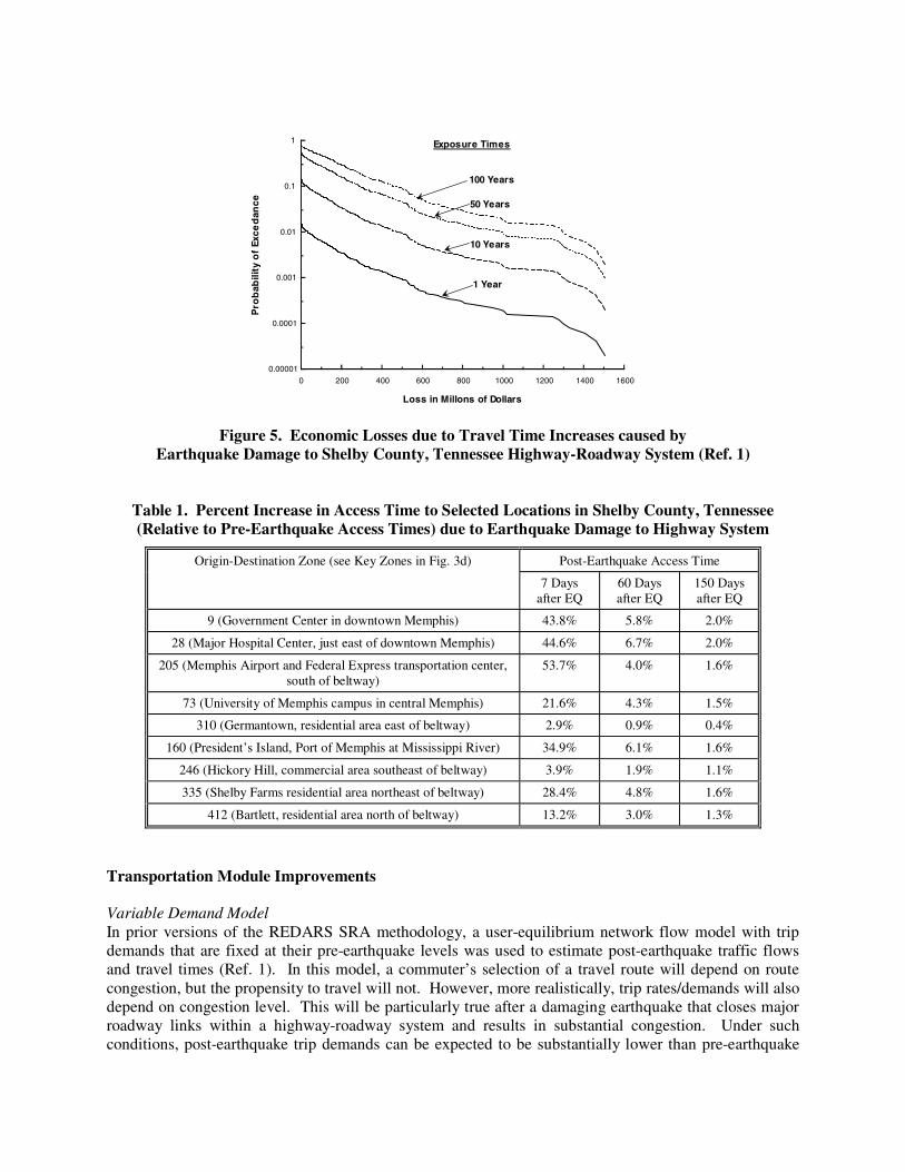
0 200 400 600 800 1000 1200 1400 1600
0.00001
0.0001
0.001
0.01
0.1
1
Loss in Millons of Dollars
Pro
bab
ility
of
Exce
dan
ce
100 Years
50 Years
10 Years
1 Year
Exposure Times
Figure 5. Economic Losses due to Travel Time Increases caused by Earthquake Damage to Shelby County, Tennessee Highway-Roadway System (Ref. 1)
Table 1. Percent Increase in Access Time to Selected Locations in Shelby County, Tennessee (Relative to Pre-Earthquake Access Times) due to Earthquake Damage to Highway System
Origin-Destination Zone (see Key Zones in Fig. 3d) Post-Earthquake Access Time
7 Days after EQ
60 Days after EQ
150 Days after EQ
9 (Government Center in downtown Memphis) 43.8% 5.8% 2.0%
28 (Major Hospital Center, just east of downtown Memphis) 44.6% 6.7% 2.0%
205 (Memphis Airport and Federal Express transportation center, south of beltway)
53.7% 4.0% 1.6%
73 (University of Memphis campus in central Memphis) 21.6% 4.3% 1.5%
310 (Germantown, residential area east of beltway) 2.9% 0.9% 0.4%
160 (President’s Island, Port of Memphis at Mississippi River) 34.9% 6.1% 1.6%
246 (Hickory Hill, commercial area southeast of beltway) 3.9% 1.9% 1.1%
335 (Shelby Farms residential area northeast of beltway) 28.4% 4.8% 1.6%
412 (Bartlett, residential area north of beltway) 13.2% 3.0% 1.3%
Transportation Module Improvements Variable Demand Model In prior versions of the REDARS SRA methodology, a user-equilibrium network flow model with trip demands that are fixed at their pre-earthquake levels was used to estimate post-earthquake traffic flows and travel times (Ref. 1). In this model, a commuter’s selection of a travel route will depend on route congestion, but the propensity to travel will not. However, more realistically, trip rates/demands will also depend on congestion level. This will be particularly true after a damaging earthquake that closes major roadway links within a highway-roadway system and results in substantial congestion. Under such conditions, post-earthquake trip demands can be expected to be substantially lower than pre-earthquake
trip demands. This will affect estimates of post-earthquake travel times and corresponding economic losses due to post-earthquake travel time delays, as well as post-earthquake access and egress times to/from key locations in the region (e.g., medical centers, airports, and fire departments). To account for this, the REDARS network analysis procedure has been upgraded to include a “variable demand” model that estimates how trip demands will vary with post-earthquake congestion level (Ref. 10). This model also accounts for the fact that economic losses due to highway network damage will depend not only on travel time delays, but also on the economic value of trips foregone due to earthquake-induced highway-system damage and traffic congestion. Freight Flows The modeling of earthquake effects on post-earthquake intra-urban freight flows is important to the estimation of economic losses caused by earthquake damage to the highway system. However, REDARS’ earlier treatment of freight flows was constrained by an absence of intra-urban freight origin-destination (O-D) trip-table data. This made it necessary to assume that freight traffic is simply a user specified fraction of automobile traffic, which limited the quality of REDARS’ estimates of post-earthquake highway-system performance. To address this issue, improved methods for estimating freight O-D trip demands are being developed under related research sponsored by the California Department of Transportation (Caltrans). These methods involve adaptation of a freight O-D estimation algorithm that was previously applied to the Los Angeles highway-roadway system (Ref. 11). Instead of relying on a freight O-D survey, this algorithm estimates truck trip movement based on intra- and inter-regional commodity flow data by industrial sectors. The algorithm is now being used to estimate truck trip movement in the San Francisco Bay area by compiling input from various regional freight data sources. This work will guide future applications of the algorithm in other regions of the country where REDARS SRA applications are carried out. Hazard and Component Modules Hazards Module The SRA Hazards Module is being updated to enable the methodology to: (a) accommodate multiple ground motion models for various regions of the United States; (b) compute source-site distances according to a wide range of distance definitions, in order to facilitate REDARS’ accommodation of other ground motion models in the future; (c) check the consistency of probabilistic estimates of ground motions from the walkthrough approach with those estimated using conventional seismic hazard analysis procedures; (d) include the four-parameter liquefaction-induced lateral spread displacement model by Bardet and his associates (Ref. 12); and (e) adapt the Youngs et al. probabilistic model for site-specific surface fault displacements (Ref. 13) to apply to probabilistic system-based evaluations carried out by the REDARS SRA methodology. Component Module The SRA Component Module is being updated to modify the process for modeling bridge repairs as a function of bridge damage state, and to extend default bridge fragility models to account for the beneficial effects of seismic retrofit. The repair model is being modified to: (a) encourage user modeling of repair costs, downtimes, and traffic state; and (b) include repair guidelines based on Caltrans experience. The encouragement for users to develop their own repair model was motivated by the fact that bridge post-earthquake repair rates will vary from region to region throughout the United States, because of regional differences in bridge construction practices, repair resources, and earthquake repair experience. Therefore, it is not plausible to specify a single default repair model in REDARS that will apply to bridges nationwide. Inclusion of repair guidelines based on Caltrans experience was motivated by their extensive post-earthquake bridge repair experience. Repair modeling of bridges outside of California can
use these experience-based guidelines as a starting point, after which user adjustments to account for regional differences in bridge construction and repair practices can be included. The default bridge fragility model used in the previously-noted validation analyses applies to un-retrofitted bridges only; i.e., they do not account for the beneficial effects of bridge retrofit. Because statewide bridge retrofit was in progress at the time of the Northridge Earthquake, this limitation of the default model probably contributed to some extent to the model’s overestimation of observed bridge damage. Therefore, as a first step for including retrofit effects into the default model, results of research by Shinozuka and his associates are being incorporated (Ref. 14). This research has used analytical investigations of the longitudinal response of several typical California bridge configurations in order to characterize the effects of column-jacket and cable-restrainer retrofitting on seismic performance of these bridges. The research is now being extended to also consider transverse bridge response. Computation-Time-Reduction Improvements Computational times required for REDARS probabilistic SRA applications are affected by the number of simulations used (which can be large), and by the time required to implement network analysis for post-earthquake system states at several times after each earthquake. Steps being taken to reduce REDARS computation times by addressing these issues are summarized below. Variance Reduction The number of simulations and earthquake scenarios considered for probabilistic SRA should be chosen to achieve target confidence levels and limits (CLLs) in the loss results. In the demonstration SRA of the Shelby County highway system summarized earlier in this paper, a binomial distribution was used to estimate CLLs in the average annual loss (AAL) caused by earthquake damage to the system. This SRA was based on a walkthrough duration of 50,000 years, which included 760 simulations with non-zero losses. The resulting CLLs were judged to be acceptable (95-percent confidence that the true value of the AAL was within ±12.6-percent of the computed AAL); however, the computer run time needed to carry out the SRA for this long walkthrough duration and large number of simulations was extensive. This issue has been addressed by considering that the number of simulations needed to achieve a target CLL will decrease as the variance of the loss distribution decreases. This led to the investigation of variance reduction methods, which use advanced statistical analysis techniques to reduce the variance in the estimate of some selected parameter (here the AAL). When applied to the SRA of the Shelby County, Tennessee highway system, it turned out that these methods led to nearly a 70-percent reduction in the number of simulations needed to achieve the CLLs indicated in the previous paragraph. Therefore, a post-processor is being added to the REDARS SRA methodology that will use variance-reduction methods to estimate CLLs for a given number of simulations. These methods, and their application within REDARS, are further described in Reference 15. Improved Time-Efficiency of Network Analysis The most time-consuming step of the SRA for each simulation is the network analysis for estimating post-earthquake traffic flows. This analysis has used a user-equilibrium model, which assumes that roadway system users will always choose travel paths that minimize their travel times. A key element of this model is a minimum time-path searching algorithm, which searches many possible paths between various O-D zone pairs to find the path that has the shortest travel time. Originally, a Moore-Pipe algorithm was used for this purpose. However, to reduce network-analysis run times, a much more efficient Dual-Simplex searching algorithm has since been included into REDARS. This algorithm has been shown to reduce network analysis run times by factors ranging from about 20-percent (for small networks) to nearly 60-percent (for large networks with many links and nodes.)
Decision Guidance The REDARS SRA methodology is not only being structured as a tool to estimate losses due to effects of highway-system earthquake damage on post-earthquake travel times and traffic flows. Rather, it is also being developed to guide highway transportation agency decision-makers during their evaluation of various seismic-risk-reduction options (such as alternative bridge strengthening or highway-system improvement strategies), and their selection of a preferred option that reduces these losses to an acceptable level. Use of REDARS as a decision-guidance tool will involve the following steps: (a) developing multiple models of the highway network, in which each model includes one of the seismic-risk-reduction options under consideration; (b) performing a SRA for each model, and estimating relative implementation-costs and losses (risks) for each risk-reduction option; and (c) structuring these cost and losses into several decision models that facilitate the quantitative comparison of the various options. The latter step will be accomplished through a new REDARS post-processor that will include both deterministic and probabilistic decision models (to accommodate either deterministic or probabilistic SRA applications). The deterministic decision models will be the principle of dominance, the maxi-min principle, and the min-max principle, and the probabilistic decision models will consist of benefit-cost, least mean total cost, mean-variance, and first-order stochastic dominance methods. Import Wizard The development of input data for REDARS SRA applications requires the use of several publicly-available databases, including: (a) the National Highway Performance Network (NHPN) database for defining network topology only (spatial coordinates); (b) the Highway Performance Monitoring System (HPMS) database for defining highway network attributes only (e.g., number of lanes, functional class, etc.); (c) the National Bridge Inventory (NBI) database which defines certain bridge attributes; and (d) regional databases for defining O-D zones and associated trip tables, NEHRP soil conditions, etc. Unfortunately, the information contained in these various databases is not always compatible. For example, the segmentation of the links in the NHPN database (network topology) is not always consistent with that of the HPMS database (link attributes). In addition, bridge coordinates from the NBI database are not always consistent with the corresponding roadway link location given in the NHPN database. The resolution of these issues in order to develop consistent input data for a REDARS SRA application can be time consuming. To reduce these user time requirements, an Import Wizard is being developed to interface with REDARS. This Wizard will guide the user through each step of the input-data development process, and will automate the resolution of many of the above inconsistencies. It will consist of a series of prototype user interfaces (graphical user interfaces and dialogue windows) that are successively activated by users and will guide them through each step of the development of the input data. Such interfaces will enable users to locate publicly available databases within the Wizard, define study region boundaries, establish the various network, soil, and bridge input databases within REDARS, define boundary conditions (e.g., trip demands on the highway network from outside of the study region), and check network-model connectivity and continuity of O-D zones. Software Development In addition to the foregoing new improvements directed toward enhanced technical capabilities and usability of the SRA methodology, this SRA research is now focusing on the programming of the methodology into what will be a public-domain software package. This programming work has led to completion of an initial demonstration software package (REDARS 1), and is now developing the public-domain software (REDARS 2).
REDARS 1 REDARS 1 is demonstration software that performs deterministic SRA of the Los Angeles, California highway-roadway system subjected to scenario earthquakes for which ShakeMap ground motion data (Ref. 16) are available. It is a simplified version of the REDARS SRA methodology, in that it considers ground shaking hazards only, and does not include any of the new improvements summarized in the foregoing paragraphs. Development of REDARS 1 was motivated by early interest in REDARS by several state highway transportation agencies, and the need to: (a) provide a simplified tool to familiarize these agencies with basic SRA concepts while the more extensive public-domain software (REDARS 2) is being developed; and (b) enable these agencies to provide early feedback regarding particular features that would be desirable to include in the forthcoming REDARS 2 software. For the Los Angeles highway system and ShakeMap ground motion cases that can be analyzed, REDARS 1 enables users to: (a) compute and display system-wide bridge damage states and highway-roadway system states at various post-earthquake times; (b) perform network analysis to estimate effects of earthquake damage on post-earthquake travel times; and (c) estimate economic losses due to travel time delays, and effects of earthquake damage on access-egress time to/from any O-D zone in the model. In addition, the user can simulate seismic upgrades to bridges and highway system improvements, and then rerun REDARS 1 to compute the effects of these improvements on post-earthquake travel times (Ref. 17). REDARS 2 REDARS 2 will be public-domain software for deterministic or probabilistic SRA of highway-roadway systems nationwide. This software will start with features and structure summarized for REDARS 1, and will then be extended to include technical and user-oriented features and improvements summarized earlier in this paper. REDARS 2 will be programmed as a stand-alone Microsoft Windows desktop application, and will include several process-flow and general-application changes (relative to REDARS 1) that are described in detailed REDARS 2 draft software specifications (Ref. 18). These specifications also include priorities, budgets, and schedules for completion of all software development tasks pertaining to general applications development, programming of SRA capabilities, software documentation, release, and support, and administration. During the remainder of this year (2004), a beta version of the REDARS 2 software will be prepared and tested, and programming of the software and Import Wizard will be completed. Preparation of user and technical documentation, implementation of a new demonstration application, and public release of the software are scheduled to be completed by the end of the following year (2005).
FUTURE DIRECTIONS This section addresses recommended future research directions for further improving the REDARS SRA methodology. These pertain to bridge modeling, network analysis, and economic loss estimation. Bridge Modeling As previously noted, REDARS’ default procedure for fragility modeling of bridges subjected to ground shaking hazards was constrained by the need to carry out rapid estimates of the seismic performance of the large number of bridges in a highway system, and to use the limited bridge attribute data contained in current federal and state computerized databases (Ref. 1). In view of these constraints, bridge performance predictions by the default procedure suffer from certain limitations, e.g., (a) they use qualitative descriptors of bridge damage that do not provide sufficient information on the extent, locations, and types of earthquake-induced bridge damage that would ordinarily be needed to estimate repair requirements; (b) they do not include certain key elements of bridge seismic performance, such as foundation and abutment performance, overall bridge system characteristics, and certain structural details that can have important effects of seismic performance. Other key limitations of current bridge modeling
procedures for SRA applications are: (c) limited information is available to guide the estimation of bridge repair requirements; and (d) procedures to estimate the seismic performance of bridges subjected to permanent ground displacement hazards (in addition to ground shaking hazards) are limited. Therefore, research to address the following bridge modeling issues is recommended:
• What should be the next-generation default bridge modeling procedures that lead to improved seismic performance predictions, while also being practical for SRA applications?
• How can current computerized bridge attribute databases be expanded to provide the input data needed to apply these procedures?
• How can bridge damage states be defined to better facilitate the estimation of bridge repair costs, downtimes, and functionality (traffic carrying capacity during repair) after an earthquake?
• What guidance can be provided for modeling of bridge repair costs, times, and functionality (ability to carry at least partial traffic while repairs are proceeding) for various damage states?
• How can fragility models be developed for bridges subjected to both ground shaking and permanent ground displacement hazards (e.g., due to liquefaction, landslide, or surface fault rupture)?
Network Analysis As noted earlier in this paper, the network analysis procedure included in the REDARS SRA methodology is based on an idealized model for estimating traveler route choice, which assumes that travelers have perfect information on traffic congestion conditions along possible alternate routes between their origin and their destination. In addition, the procedure does not account for the so-called “boundary problem”, i.e., effects of earthquake damage on trips whose routes would ordinarily pass through the system being analyzed, but whose origins or destinations are located outside of that system. Therefore, research is recommended to address the following questions:
• Can stochastic route-choice models be developed to simulate effects of uncertainties in route choice because of imperfect traveler information on traffic conditions along candidate alternative routes?
• How might SRA be carried out for a larger region that surrounds the particular region under investigation, in order to estimate effects of earthquake damage on trips through the system that originate or end outside of the system?
Economic Losses The REDARS SRA methodology currently used a first-order model to estimate economic losses due to earthquake-induced travel time delays (Ref. 19). This procedure accounts for the percentage of the total traffic that is automotive vs. freight, estimated vehicle-occupancy rates and associated unit costs, and estimated costs per gallon of excess fuel used because of travel time delays. Possible improvements in economic loss predictions may be realized through: (a) integration of spatial models of the region’s economic activity system with the transportation network analysis (including improvements summarized earlier in this paper); and (b) modeling of higher order economic impacts. Research to investigate the feasibility of including these improvements in future versions of the REDARS SRA methodology is recommended.
CONCLUDING COMMENTS The REDARS SRA methodology summarized in this paper estimates how earthquake damage to a highway-roadway system will affect post-earthquake traffic flows and travel times, and the corresponding economic losses and other consequences of this damage (e.g., reduced access to key emergency response facilities). It also can be used to enable decision makers to assess how various seismic risk reduction

options under consideration affect post-earthquake system-wide travel times, and to therefore make a more informed selection of a preferred option to implement. In closing, a central focus of this SRA research and development program has been the needs of potential future users from federal, state, and local transportation agencies nationwide. Vehicles for user feedback have included: (a) meetings/mini-workshops at various Caltrans district offices; (b) Highway Seismic Research Council (HSRC) meetings conducted as part of the FHWA-MCEER highway research project; and (c) Tri-Center research-collaboration workshops involving highway-transportation agencies nationwide as well as the three national earthquake research centers in the United States (MCEER, the Pacific Earthquake Engineering Research Center, and the Mid-America Earthquake Center). During these interactions, users have identified the benefits of SRA in enabling them to more effectively address key user needs related to: (a) pre-earthquake planning of bridge design/retrofit programs, assessment of seismic performance of critical lifeline routes, and assessment of the adequacy of available repair resources; and (b) post-earthquake (real-time) assessment of alternative traffic management strategies and coordination of emergency-response activities between agencies. The meeting of these user needs will continue to be a major focus of future SRA research under this program
ACKNOWLEDGEMENTS The authors gratefully acknowledge: (a) FHWA and MCEER for their financial support of this research; (b) The management of the FHWA-MCEER project -- Ian Buckle of the University of Nevada at Reno, and Jerry O’Connor of MCEER, George Lee and Michel Bruneau of State University of New York at Buffalo, and Phil Yen of FHWA -- for their guidance throughout this research; and (c) Caltrans financial support of a current REDARS Demonstration Project, and the encouragement of Mandy Chu and Cliff Roblee of their management team for this project.
REFERENCES 1. Werner SD., Taylor CE, Moore JE II, Walton JS, and Cho S. A Risk-Based Methodology for
Assessing the Seismic Performance of Highway Systems. MCEER-00-0014. Buffalo NY: Multidisciplinary Center for Earthquake Engineering Research. 2000.
2. Taylor CE, Werner SD, and Jakubowski S. “Walkthrough Method for Catastrophe Decision Making.”
Natural Hazards Review, ASCE 2001; 2(4): 193-202. 3. Mander JB and Basoz N. Seismic Fragility Theory for Highway Bridges. Proceedings of the Fifth
U.S. Conference on Lifeline Earthquake Engineering, Seattle WA. 31-40. 1999. 4. Frankel A, Mueller C, Barnhard T, Perkins D, Leyendecker EV, Dickman N, Hanson S., and Hopper
M. National Seismic Hazard Maps, Documentation June 16, 1996. Open-File Report 96-532. Denver: United States Geological Survey. 1996.
5. Hwang HHM and Huo J-R. “Attenuation Relations of Ground Motion for Rock and Soil Sites in
Eastern United States.” Soil Dynamics and Earthquake Engineering. 16: 363-372, 1997. 6. Youd TL. Screening Guide for Rapid Assessment of Liquefaction Hazard at Highway Bridge Sites.
MCEER-98-0005. Buffalo NY: Multidisciplinary Center for Earthquake Engineering Research,. 1998.
7. Jernigan JB and Hwang HHM. Inventory and Fragility Analysis of Memphis Bridges, Center for Earthquake Research and Information, University of Memphis, Memphis TN, Sept. 15 1997.
8. Youd TL. “Chapter 6, Pavements”, Seismic Retrofitting Manual for Highway Systems --Volume III,
Screening, Evaluation, and Retrofitting of Retaining Structures, Slopes, Tunnels, Culverts, and Pavements, Multidisciplinary Center for Earthquake Engineering Research, Buffalo NY, 1999 .
9. Cho SC, Huyck CK, Ghosh S, and Eguchi RT. A Validation Study of the Risks from Earthquake
Damage to Roadway Systems (REDARS) Loss Estimation Software Program. Proceedings of Sixth U.S. National Conference on Lifeline Earthquake Engineering, Long Beach CA. 2003, 878-885.
10. Cho SC, Fan YY, and Moore JE II. Modeling Transportation Network Flows as a Simultaneous
Function of Travel Demand, Earthquake Damage, and Network Level Service. Proceedings of Sixth U.S. National Conference on Lifeline Earthquake Engineering, Long Beach CA. 2003, 868-877.
11. Cho SC, Gordon P, Moore JE II, Richardson HW, Shinozuka M, and Chang SE. Integrating
Transportation Network and Regional Economic Models to Estimate the Cost of a Large Urban Earthquake. Journal of Regional Science 2001, 41(1): 39-65.
12. Bardet J-P, Tobita T, Mace N, and Hu J. Regional Modeling of Liquefaction-Induced Ground
Deformation. Earthquake Spectra 2002. 18(1): 19-45. 13. Youngs RR, Arabasz WJ, Anderson RE, Ramelli AR, Ake JP, Slemmons DB, McCalpin JP, Doser
DJ, Fridrich CJ, Swan FH III, Rogers AM, Yount JC, Anderson LW, Smith KD, Bruhn RL, Knuepfer PL, Smith RB, dePolo CM, O’Leary DW, Coppersmith KJ, Pezzopane SK, Schwartz DP, Whitney JW, Olig SS, and Toro GR. A Methodology for Probabilistic Fault Displacement Hazard Analysis. Earthquake Spectra 2003. 19(1): 191-218.
14. Kim S-H and Shinozuka M. Fragility Curves for Concrete Bridges Retrofitted by Column Jacketing
and Restrainers. Proceedings of Sixth U.S. National Conference on Lifeline Earthquake Engineering, Long Beach CA. 2003., 906-915.
15. Perkins D and Taylor CE. Earthquake Occurrence Modeling for Evaluating Seismic Risks to
Roadway Systems. Proceedings of Sixth U.S. National Conference on Lifeline Earthquake Engineering, Long Beach CA. 2003., 859-867.
16. Wald DJ, Naecker PA, Roblee C, and Turner L. Development of a ShakeMap-Based Earthquake
Response System within California. Proceedings of Sixth U.S. National Conference on Lifeline Earthquake Engineering, Long Beach CA. 2003., 113-122.
17 Werner SD, Lavoie J-P, Eitzel C, Cho S, Huyck CK, Ghosh S, Eguchi RT, Taylor CE, and Moore JE
II. REDARS 1: Demonstration Software for Seismic Risk Analysis of Highway Systems. MCEER-03-SP01. Buffalo NY: Multidisciplinary Center for Earthquake Engineering Research 2003. 17-34.
18. REDARS 2 Software Specifications and Development Plan. Oakland CA: Seismic Systems &
Engineering Consultants. 2004. 19. Appendix B, Northridge Earthquake Traffic Recovery Study, Procedure for Simulating Area-Wide
Delay/ Economic Cost of Delay. Interstate 10 Recovery Report, Northridge Earthquake Recovery, Los Angeles CA: California Department of Transportation District 7, Office of Operations. 1994.


![May 27, 1905, Vol. 80, No. 2083 - FRASER · 2018. 11. 7. · fr May27,1905.]:hechronicle. 2189 May27,1905.]:hechronicle. 2189 and" '' and — — commission Commission Commission,](https://img.pdfslide.us/doc/110x75/60d21e52dae14e41f22482be/may-27-1905-vol-80-no-2083-fraser-2018-11-7-fr-may271905hechronicle.jpg)