Embed Size (px)
Citation preview

J Seismol (2009) 13:339–361DOI 10.1007/s10950-008-9117-z
ORIGINAL ARTICLE
New data on the Indus Kohistan seismic zoneand its extension into the Hazara–Kashmir Syntaxis,NW Himalayas of Pakistan
MonaLisa · Azam A. Khwaja · M. Qasim Jan ·Robert S. Yeats · Ahmad Hussain ·Shahid A. Khan
Received: 22 June 2007 / Accepted: 26 June 2008 / Published online: 30 August 2008© Springer Science + Business Media B.V. 2008
Abstract This paper deals with the data obtainedfrom local networks in northern Pakistan for 251earthquakes of magnitude ≥4.0 for October 8,2005 to December 31, 2006 period. The studypresents focal mechanism solutions (FMS) of 12pre- (1904–2005) and 17 post- (October 8, 2005–December, 2005) Muzaffarabad Earthquake, theirdetailed tectonic interpretation, and correlationwith surface evidence of co-seismic rupture withpublished synthetic aperture radar data. Distrib-ution of landslides obtained from National Engi-neering Services of Pakistan and the earthquake
MonaLisa (B) · M. Q. JanDepartment of Earth Sciences,Quaid-i-Azam University, Islamabad, Pakistane-mail: [email protected]
A. A. KhwajaHigher Education Commission Pakistan,Islamabad, Pakistan
R. S. YeatsGeosciences, Oregon State University and EarthConsultants International, Corvallis, OR, USA
A. HussainGeological Survey of Pakistan, Peshawar, Pakistan
S. A. KhanCentre for Earthquake Studies, Islamabad, Pakistan
damages are also discussed. Aftershock distribu-tion, which is more prominent in the crystallinezone (northwest of Muzaffarabad), defines a50-km-wide NW–SE trending zone that extendsfor 200 km from the main mantle thrust to thecenter of the Hazara–Kashmir Syntaxis. The FMSof the main shock and 16 aftershocks having mag-nitude ≥4.0 indicate thrusting to be the dominantmechanism with rupture planes having NW–SEtrend and NE dip. In addition, 12 FMS of pre-Muzaffarabad Earthquake (1904–2004) from thesame area have been determined and results arecompared. This leads to the conclusion that thewedge-shaped NW–SE trending blind zone, re-ferred to by earlier workers as the Indus KohistanSeismic Zone (IKSZ), has been activated duringthe Muzaffarabad earthquake. The right-lateralcomponent in all FMS, supported by the surfaceevidences, suggests the involvement of Balakot–Bagh Fault (BBF). We propose that the IKSZ isthe source of the October 8, 2005 Muzaffarabadearthquake that reactivated the BBF. Further-more, the IKSZ does not end at the nose of thesyntaxis but extends further southeast of it. Tec-tonic complexity seems to be due to a variety offactors. Also, thrust and reverse solutions nearthe northern collisional boundary (main man-tle thrust) have mostly NE/SW-directed P-axisorientations. From the detailed FMS analysis,three conclusions have been drawn: (1) Shallowevents (depth ≤10 km) with prominent strike slip

340 J Seismol (2009) 13:339–361
solutions (earlier earthquakes) are associated withthe surface strike slip faults (e.g., MuzaffarabadFault) and/or the Besham domal structure; (2)moderate depth events (depth 10–25 km) withthrust/reverse solutions but having minor right-lateral strike slip component (all Muzaffarabadearthquakes and two earlier) are associated withthe IKSZ; (3) deeper earthquakes (depth belowIKSZ) with pure thrust/reverse solutions maybe related to the under-thrusting of the Indianplate beneath the IKSZ, which represents a majorthrust zone. Imbricate thrusting and breaking andthickening of the crust are considered to be causedby steep bending of the under-thrusting plate atthe collisional boundary.
Keywords Co-seismic rupture and landslides ·Focal mechanism solutions ·Hazara–Kashmir Syntaxis ·Indus Kohistan seismic zone ·October 8, 2005 Muzaffarabad earthquake
1 Introduction
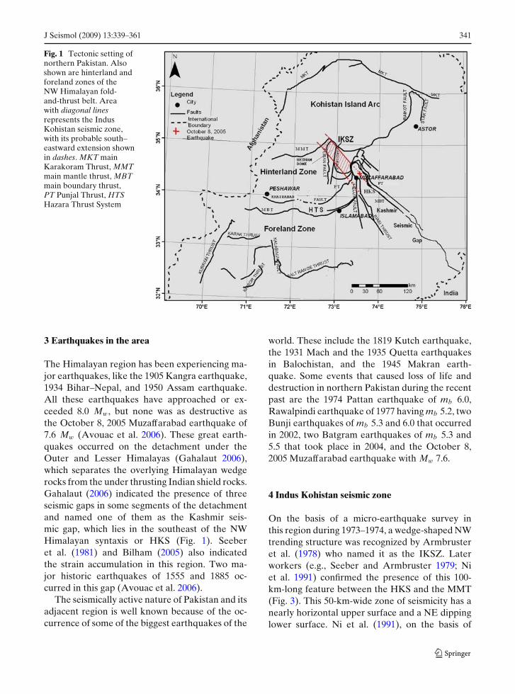
An earthquake of Mw 7.6 struck the northeasternpart of Pakistan on 8 October 2005 at 08:50:38 a.m.(local time), with its epicenter about 19 km NE ofMuzaffarabad (Fig. 1). The local seismic networkreported its location within the northwest trendingHazara–Kashmir Syntaxis (HKS), an antiformalstructure in the hinterland zone of the north-west Himalayas of Pakistan (Wadia 1931; Kazmiand Jan 1997). The HKS is an expression of thechange in the direction of Himalayan thrustingfrom southwest to southeast (Baig and Lawrence1987). Major faults, like the Punjal Thrust andthe main boundary thrust (MBT), are foldedaround the apex of the syntaxis, whereas alongits western limb, the Punjal thrust, MBT, and theMuzaffarabad thrust or Balakot–Bagh Fault aretruncated by the active strike slip Jhelum Fault(Baig 2006), as shown in Fig. 1.
The epicentral distribution of aftershocks liesNW of the main shock epicenter, beyond thesyntaxial bend of HKS in the NW trending In-dus Kohistan seismic zone (IKSZ), a wedge-shaped seismic zone first reported by Armbrusteret al. (1978). With the help of (1) focal mecha-
nism solutions (FMS) of 29 earthquakes (16 af-tershocks of the Muzaffarabad earthquake and12 earlier events), (2) vertical projection of the17 FMS of Muzaffarabad earthquake on the100-km-wide northeast trending cross-section ofArmbruster et al. (1978) modified by Bilham(2005), (3) about 130-km-wide and 160-km-longparallel cross-section along the Indus Kohistanseismic zone, and (4) evidence for fault ruptureand correlation of synthetic aperture radar (SAR)data of Fujiwara et al. (2006) with the 17 FMS(Muzaffarabad earthquake data) for the activefaults identification, we propose that IKSZ isnot only the source of the 2005 MuzaffarabadEarthquake, further reactivating the Balakot-Bagh Fault (BBF) and several other faults in thearea. This paper also summarizes the distributionof landslides and destruction caused in the area asan expression of the distribution of strong groundmotion.
2 Seismotectonic settings
Earthquakes in the northern part of Pakistan arethe result of the ongoing northward subductionof the Indian plate beneath the Eurasian plateat a rate of about 40 mm/year. As a result ofthis collision, the highest mountain ranges of theworld, the Himalaya, Karakoram, Pamir, and Hin-dukush, have formed. In this area of dominantcompression, transpressional tectonic features arealso present (Sercombe et al. 1998; MonaLisaet al. 2004a, 2007). The north- and northeast-directed compression has produced major thrustfaults such as the Shyok Suture (or main Karako-ram Thrust, MKT), Indus Suture (or main mantlethrust, MMT), and the MBT shown in Fig. 1,as well as many active faults of variable length,e.g., the Himalayan frontal thrust, etc. Transpres-sional features in the area include strike slip faultsnamed as Jhelum, Thakot, Puran (Nakata et al.1991), and Raikot Faults (Figs. 1 and 3). In addi-tion to these, existence of shallow to deep crustalfaults, like the NW trending Indus Kohistan seis-mic zone of Armbruster et al. (1978) and BBF ofKhan and Ali (1994; based on gravity data), hasalso been proposed.
J Seismol (2009) 13:339–361 341
Fig. 1 Tectonic setting ofnorthern Pakistan. Alsoshown are hinterland andforeland zones of theNW Himalayan fold-and-thrust belt. Areawith diagonal linesrepresents the IndusKohistan seismic zone,with its probable south–eastward extension shownin dashes. MKT mainKarakoram Thrust, MMTmain mantle thrust, MBTmain boundary thrust,PT Punjal Thrust, HTSHazara Thrust System
3 Earthquakes in the area
The Himalayan region has been experiencing ma-jor earthquakes, like the 1905 Kangra earthquake,1934 Bihar–Nepal, and 1950 Assam earthquake.All these earthquakes have approached or ex-ceeded 8.0 Mw, but none was as destructive asthe October 8, 2005 Muzaffarabad earthquake of7.6 Mw (Avouac et al. 2006). These great earth-quakes occurred on the detachment under theOuter and Lesser Himalayas (Gahalaut 2006),which separates the overlying Himalayan wedgerocks from the under thrusting Indian shield rocks.Gahalaut (2006) indicated the presence of threeseismic gaps in some segments of the detachmentand named one of them as the Kashmir seis-mic gap, which lies in the southeast of the NWHimalayan syntaxis or HKS (Fig. 1). Seeberet al. (1981) and Bilham (2005) also indicatedthe strain accumulation in this region. Two ma-jor historic earthquakes of 1555 and 1885 oc-curred in this gap (Avouac et al. 2006).
The seismically active nature of Pakistan and itsadjacent region is well known because of the oc-currence of some of the biggest earthquakes of the
world. These include the 1819 Kutch earthquake,the 1931 Mach and the 1935 Quetta earthquakesin Balochistan, and the 1945 Makran earth-quake. Some events that caused loss of life anddestruction in northern Pakistan during the recentpast are the 1974 Pattan earthquake of mb 6.0,Rawalpindi earthquake of 1977 having mb 5.2, twoBunji earthquakes of mb 5.3 and 6.0 that occurredin 2002, two Batgram earthquakes of mb 5.3 and5.5 that took place in 2004, and the October 8,2005 Muzaffarabad earthquake with Mw 7.6.
4 Indus Kohistan seismic zone
On the basis of a micro-earthquake survey inthis region during 1973–1974, a wedge-shaped NWtrending structure was recognized by Armbrusteret al. (1978) who named it as the IKSZ. Laterworkers (e.g., Seeber and Armbruster 1979; Niet al. 1991) confirmed the presence of this 100-km-long feature between the HKS and the MMT(Fig. 3). This 50-km-wide zone of seismicity has anearly horizontal upper surface and a NE dippinglower surface. Ni et al. (1991), on the basis of

342 J Seismol (2009) 13:339–361
relocated hypocenters, have identified two seismiczones within the IKSZ: a shallow zone extendingfrom the surface to a depth of 8 km and a morepronounced midcrustal zone lying at depths of12 to 25 km. The upper boundary at a depth ofabout 12 km is considered to represent a decolle-ment surface that decouples the sediments andmetasediments from the basement.
The IKSZ is seismically the most active struc-ture in the region, as it is capable of generatinglarge events. It is predominantly a thrust faultwith a NW-striking and NE-dipping plane paral-lel to the general trend of the MBT to the SEof Muzaffarabad. However, one cannot equatethe IKSZ with the MBT because of their differ-ent tectonic history, as based on surface geology(Gahalaut 2006). The MBT and the Hazara thrustsystem (HTS) are among the many structural units(Fig. 1). The structural complexities arise whenArmbruster et al. (1978) argue that the MBTdoes not extend past the HKS to join the IKSZ.Prior to 2005, the most destructive earthquake,associated with the IKSZ, was the 28 December,1974 Pattan earthquake with mb 6 magnitude.Seeber et al. (1981), however, proposed a shallowdipping seismically active detachment under theOuter and Lesser Himalayas from the steeper andmostly aseismic basement thrust under the HigherHimalayas that extends further north past theHKS. This 200- to 300-km width detachment joinsIKSZ and extends northward beyond it. The ques-tion arises whether the IKSZ or the detachmentis responsible for the Muzaffarabad earthquake.This can be answered by taking into considerationthe depth of the main event and its aftershocks,as will be discussed in the section of focal mecha-nisms and aftershock distribution.
5 Data sources
Pakistan seismicity has been reported by localobservatories as well as those of the UnitedStates Geological Survey, International Seismo-logical Centre, and British Association for theAdvancement of Science. The quality of detec-tion of the earthquake data by the local ob-servatories is debatable. There are three majorsources of local instrumental data, i.e., the net-
works of the Water and Power DevelopmentAuthority (WAPDA), Pakistan MeteorologicalDepartment, and those of the Pakistan AtomicEnergy Commission (PAEC). The station cover-age is more complete for northern Pakistan thanfor the rest of the country.
Approximately 6,000 aftershocks were re-corded by the telemetered seismic networksinstalled and operated under the Pakistan govern-ment agencies (WAPDA and PAEC) between theOctober 8, 2005 Muzaffarabad earthquake andMarch 2007. Of these, 423 aftershocks have beenconsidered within a 200 × 200-km area (Fig. 4) us-ing the data of 17 seismic stations of the local ob-servatories for a preliminary analysis. Then, usingthe HYPO71 software, all these 423 earthquakeswere relocated. Only 251 earthquakes were re-tained for which at least two S arrival times couldbe read. The area in this study includes from northto south, the crystalline nappe zone, HKS, and apart of HTS as shown in Fig. 2.
The local network uses its own P-wave ve-locity model, whereas for S-wave velocities, it isassumed that the Vp/VS ratio is 1.73. For themagnitude calculation, correction and simulationof standardized instruments have been done us-ing peak-to-peak amplitudes. An error of ±2 to5 km for location and depths has been estimatedfor the 251 readings with magnitude ≥4.0. Theseaftershock data have been plotted on the seis-micity map of MonaLisa et al. (2006), which in-cludes both the pre-instrumental (pre-1904) andinstrumental (after 1904) data (Fig. 2). This widerange of data (251) reflects the high seismicity inthe area and also indicates the high sensitivity ofthe seismic stations. About 147 aftershocks weredocumented in the first day after the initial shock,one of which had a magnitude of 6.4 Mw (localobservatory). Twenty-eight occurred with a mag-nitude greater than 5 during the first 4 days afterthe main event.
6 Focal mechanism solutions
A total of 29 earthquakes (Mw ≥4) were se-lected for the FMS, out of which, 12 are pre-Muzaffarabad earthquake (1964–2004) and 17are post-Muzaffarabad earthquake (October 8,

J Seismol (2009) 13:339–361 343
Fig. 2 Seismicity map of the area. Red crosses are the after-shocks of October 8, 2005 Muzaffarabad earthquake. Redbox is 200 × 200 km and shows occurrence of 423
aftershocks for which location, depth, and magnitudeare known. The left inset shows depths of 251 relocatedaftershocks
2005–December, 2005), including the main shock(Table 1). The selection of these 29 earthquakesis primarily based on the availability of relevantparameters like azimuthal angle, takeoff angle,and polarities, etc., which are necessary for thedetermination of FMS. The lower hemispherefault plane solutions of single events were deter-mined from the first motion data. The earthquakeswith a minimum of 8 P-wave polarities were se-lected for the focal mechanism studies. Two soft-ware programs, namely AZMTAK and PMAN ofSuetsugu (1997) in FORTRAN, have been em-ployed. The former computes the epicentral dis-tance and azimuth for each station and obtainsthe takeoff angle. The latter generates the focalmechanism diagrams based on input of geographiccoordinates, magnitude, focal depth, and P-wavepolarity for each event. The quality of the polarityreading, the type of wave (direct or refracted), andthe azimuthal coverage on the focal sphere were
taken into consideration in order to have betterreliability.
Through geological mapping, published data(e.g., Nakata et al. 1991; Gee 1980; Baig andLawrence 1987; Searle and Khan 1996; Hussainand Yeats 2002; Hussain et al. 2004, 2008) and useof remote sensing techniques (MonaLisa et al.2006, 2008; MonaLisa in press) have delineated anumber of active faults in the fold and thrust belt(Fig. 1). All the 29 pre- and post-Muzaffarabadearthquake FMS are plotted on this map (Fig. 3)and are discussed below in relation to the struc-tures present in the area. Their correlation withIKSZ, along with the depth sections (Fig. 6a, b)thus prepared, is also interpreted.
6.1 FMS interpretation
We have named pre-2005 earthquakes FMS as P1,P2. . . P12 and the Muzaffarabad earthquake FMS

344 J Seismol (2009) 13:339–361
Table 1 Source parameters of the 29 earthquakes used in FMS determination
FMS nos. Date (D/M/Y) Time (H:M:S) Latitude (N) Longitude (E) Depth (km) Magnitude (Mw)
Pre-2005 FMSP1 8/11/65 21:23:09 34.6 73.3 65 5.1P2 6/4/66 1:51:53 34.91 73.06 54 5.6P3 28/4/71 15:12:42 34.44 73.6 43 5.3P4 27/12/71 20:59:39 34.98 73.02 55 5.7P5 27/09/72 20:24:56 35.07 72.91 49 5.3P6 28/12/74 12:11:46 35.06 72.91 15 6.4P7 28/12/74 22:38:53 34.99 73.1 21 5.3P8 7/4/75 6:41:02 34.91 72.97 53 5.5P9 28/12/84 16:28:01 34.61 73.61 47 5P10 17/7/2000 5:26:00 34.59 72.89 10 5.5P11 14/02/2004 11:56:58 34.81 73.19 10 5.4P12 14/02/2004 10:30:22 34.828 73.255 10 5.5
Muzaffarabad earthquake FMS1 08/10/05 03:50 34.42 73.52 13 7.62 08/10/05 10:46 34.76 73.28 8 6.43 08/10/05 12:08 34.56 73.20 10 5.74 08:10:05 12:25 34.76 73.40 10 5.75 08:10:05 21:13 34.77 73.45 10 6.06 08/10/05 21:45 34.65 73.36 10 5.77 09/10/05 08:30 34.56 73.51 10 5.88 09/10/05 19:20 34.38 73.79 10 5.59 12/10/05 20:23 34.90 73.46 10 5.810 13/10/05 20:49 34.74 73.19 10 5.711 19/10/05 02:33 34.66 73.53 05 5.812 19/10/05 03:16 34.90 73.38 10 5.513 23/10/2005 15:04 34.88 73.19 10 5.914 28/10/05 21:34 34.74 73.13 10 5.515 06/11/05 02:11 34.47 73.54 10 5.716 21/11/05 08:26 34.84 73.40 10 5.517 25/12/05 08:02 34.50 73.30 10 5.7
as 1, 2, 3. . . 17 (Fig. 3). The order of numbering isaccording to the date of occurrences (1 being theoldest and 17 the most recent).
6.2 FMS P2, P4, P5, P8, and 9, 12, 13
All of these events, except P8, are situated near oralong the MMT that forms the northern boundaryof the study area (Fig. 3). The event P8 is locatedon the right-lateral Thakot Fault, which is oneof the important active faults in the area. Theother important fault is left-lateral Puran faults(Baig and Lawrence 1987; Baig et al. 1989). ForFMS 9, 12, and 13 (Muzaffarabad earthquake af-tershocks), the focal depth is 10 km, confirmingthe activation of IKSZ. Focal depths for the events2, 4, 5, and 8 range from 49 to 55 km (Table 1),
thereby indicating seismic activity deeper thanthe IKSZ. Armbruster et al. (1978) and Seeberand Armbruster (1979) have documented seismicactivity from these deeper levels. According to Niet al. (1991), a zone of diffuse seismicity occursbelow the IKSZ up to a depth of 50 km andindicates intraplate activity in the Indian plate.Armbruster et al. (1978) recognized seismic activ-ity to a depth of 70 km. It is inferred to be withinthe basement of the plate or in the uppermostmantle due to a steep bending of the plate. Mostworkers, including those basing their interpreta-tion on gravity data (e.g., Khan and Ali 1994),agree on the presence of the Indian plate under-thrusting beneath the Himalayas. There is generalagreement that thrusting is the major deforma-tional process operating at these levels. However,

J Seismol (2009) 13:339–361 345
Fig. 3 Location of focal mechanism solutions (FMS) of29 earthquakes, including the Muzaffarabad earthquake,its 16 aftershocks (red color), and 12 pre-Muzaffarabad
earthquake events (black color) on the structural mapcompiled from various sources given in the text
in the case of FMS 9, 12, and 13 (Muzaffarabadearthquake aftershocks), the focal depth is 10 km,again confirming the activation of the IKSZ.
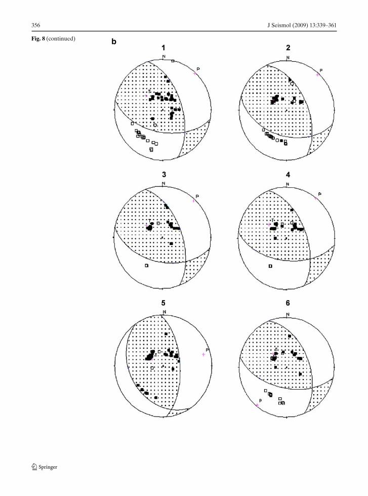
Focal mechanism solutions of these events sup-port this contention, as all solutions show thrust-ing (Fig. 8). All include a plane that strikes in theNW–SE direction and dips NE, except P2 and P4that have NE and N striking planes, respectively(Fig. 8). P-axis orientations of these events areNE–SW (Table 2). Following Armbruster et al.(1978), it is believed that the IKSZ is responsiblefor the shallow seismic activity, whereas imbricatethrusting, breaking, and thickening of the crust toa depth of 60 to 70 km is producing thrusts withmostly shallow dips in an overall steeply dipping
seismic pattern. Thus, the deeper earthquakesare considered to be intraplate events within thelower crust (lower part of the Himalayan crust).
6.3 FMS P6 and P7
These events, like the P2 and P4, are also locatednear the MMT (Fig. 3). P6, with a magnitude of6.4 Mw, was the second largest earthquake to haveoccurred in the study area. Focal depths for theseevents are 15 and 21 km, respectively (Table 1).An important fault located near the epicenter ofP6 is the left lateral Puran Fault (Baig et al. 1989).
From the earlier description, it is known thatthe IKSZ occurs at depths ranging from 12 to

346 J Seismol (2009) 13:339–361
Table 2 FMS parameters obtained for the 29 earthquakes
FMS no. Nature of FMS Fault plane (FP) Auxiliary plane (AP) P-Axis T-Axis
Strike Dip Strike Dip Strike Plunge Strike Plunge
Pre-2005 FMSP1 THRUST 142◦ 33◦NE 289◦ 62◦ 31◦ 15◦ 164◦ 69◦P2 THRUST 308◦ 7◦NE 40◦ 90◦SE 136◦ 44◦ 303◦ 45◦P3 THRUST 339◦ 26◦NE 166◦ 64◦SW −106◦ 19◦ 82◦ 70◦P4 THRUST 331◦ 12◦ NE 87◦ 85◦S 186◦ 39◦ 345◦ 49◦P5 THRUST 320◦ 13◦NE 154◦ 78◦SW 242◦ 33◦ 68◦ 57◦P6 REVERSE 348◦ 52◦NE 105◦ 60◦SW 225◦ 5◦ 321◦ 53◦P7 THRUST 329◦ 21◦E 135◦ 70◦ S −131◦ 24◦ 37◦ 65◦P8 THRUST 7◦ 11◦NE 175◦ 79◦NW −93◦ 34◦ 82◦ 56◦P9 THRUST 284◦ 34◦NE 162◦ 70◦ −129◦ 21◦ 108◦ 56◦P10 RLSS 312◦ 85◦NE 42◦ 88◦NW 177◦ 2◦ −267◦ 4◦P11 RLSS 356◦ 84◦NE 88◦ 71◦SW 43◦ 9◦ 310◦ 18◦P12 RLSS 356◦ 84◦NE 88◦ 71◦SW 43◦ 9◦ 310◦ 18◦
Muzaffarabad earthquake FMS1 THRUST 342◦ 57◦NE 101◦ 53◦NW 42◦ 2◦ 310◦ 53◦2 THRUST 335◦ 54◦NE 107◦ 48◦NW 42◦ 4◦ 305◦ 63◦3 THRUST 340◦ 57◦NE 102◦ 51◦NW 42◦ 4◦ 306◦ 56◦4 THRUST 339◦ 56◦NE 97◦ 54◦NW 38◦ 1◦ 307◦ 53◦5 THRUST 357◦ 62◦NE 145◦ 32◦NW 75◦ 15◦ 300◦ 69◦6 THRUST 339◦ 51◦NE 102◦ 56◦NW 219◦ 3◦ 314◦ 57◦7 THRUST 353◦ 69◦NE 101◦ 52◦NW 50◦ 10◦ 310◦ 44◦8 THRUST 321◦ 64◦NE 179◦ 31◦NW 65◦ 17◦ 198◦ 66◦9 THRUST 313◦ 49◦NE 95◦ 48◦NW 24◦ 0◦ 293◦ 70◦10 THRUST 1◦ 77◦NE 113◦ 31◦NW 69◦ 27◦ 302◦ 50◦11 THRUST 320◦ 43◦NE 124◦ 48◦NW 138◦ 3◦ 329◦ 82◦12 THRUST 334◦ 60◦NE 105◦ 41◦NW 43◦ 10◦ 294◦ 62◦13 THRUST 309◦ 48◦NE 101◦ 46◦NW 25◦ 1◦ 291◦ 75◦14 THRUST 341◦ 57◦NE 99◦ 54◦NW 41◦ 2◦ 309◦ 53◦15 THRUST 157◦ 81◦NE 52◦ 33◦NW 88◦ 28◦ 35◦ 45◦16 THRUST 322◦ 52◦NE 103◦ 45◦NW 34◦ 4◦ 293◦ 69◦17 THRUST 358◦ 66◦NE 104◦ 59◦NW 52◦ 4◦ 319◦ 40◦
25 km. According to Ni et al. (1991), most IKSZevents are deeper than 12 km in which the shal-low events are associated with the reactivatedparts of MMT, while the deeper earthquakes maybe related to the under thrusting of the Indianplate beneath the IKSZ. The lower portion of theIKSZ (12–25 km) represents a major thrust zone(Armbruster et al. 1978; Ni et al. 1991).
Various workers named P6 as the Pattan earth-quake of 1974 and determined its FMS. The epi-center is located approximately 10 km north ofMMT in a terrain of garnet granulites overly-ing ultramafic rocks (Arif and Jan 2006; Garridoet al. 2006). Pennington (1979) and Khurshid et al.(1984) have inferred thrust faulting with the rup-ture plane striking NW and dipping NE, but the
solution of Chandra (1975) shows NE strike withdip in the NW direction. Composite fault planesolutions obtained from the IKSZ show reversefaulting along NW striking planes dipping to-wards the NE or more steeply towards the SW(Armbruster et al. 1978; Ni et al. 1991) or strikeslip solutions or a mixture of both (Armbrusteret al. 1978). P7 is an aftershock of the Pattan earth-quake. Solutions obtained in the present study(Fig. 8) are of reverse faulting, with a componentof right-lateral strike slip in the case of the P6. Asimilar NW trend, dipping 55◦ towards the NE,obtained by the above-named workers, is alsoobtained here (Table 2). Like Pennington (1979),a right-lateral strike slip component is inferred.Finally, the solutions support the contention that

J Seismol (2009) 13:339–361 347
a major active thrust fault zone (IKSZ) underliesthe decollement.
6.4 FMS P11, P12, and 2, 4, 5, 10, 14, 16
The events P11 and P12 are situated near theIndus Suture, locally named as MMT, whereasevents 2, 4, 5, 10, 14, and 16 are situated midwaybetween the MMT and the syntaxis region faults(Fig. 3). The makeup of the Indus Suture in north-ern Pakistan ranges from a sharp contact betweenthe Kohistan magmatic arc and the Indian Plate toa melange showing substantial lithological varia-tion from place to place (Jan and Rafiq 2007). TheIndian Plate to the south of MMT may comprisea stack of nappes. An important thrust occurringin the west central part of the area under study,immediately south of the MMT, is the BannaThrust on which rides the Banna Nappe (Treolaret al. 1989). The IKSZ underlies this area. P11and P12 are for the earthquakes that precededimmediately the Muzaffarabad earthquake andoccurred on 14 February 2004. Focal depth of allthe eight events is 10 km (Table 1), except for FMS2 (i.e., 8 km). In all the solutions (Fig. 8), the nodalplanes trend NW–SE and are considered to be therupture planes. Their dip direction towards theNE is in agreement with that of the IKSZ. A right-lateral component, along with reverse/thrust, isprominent in all the solutions (Fig. 8). They arefrom an area located to the east of the Beshamdome (Fig. 3). In this domal structure, basementuplift is an ongoing process (Baig and Lawrence1987; Treolar et al. 1989) and may be the rea-son for generating right-lateral strike slip faultsin this part of the study area. This confirms thecontention that the reverse faulting with strikeslip component is not uncommon in Himalayanearthquakes.
6.5 FMS P10
This event is located close to the nearly N–S trend-ing right-lateral strike slip Thakot Fault (Fig. 3),which is considered to be the surface expression ofthe Tarbela seismic zone. This zone, lying betweendepths of 8 and 18 km (8 to 15 km according to Niet al. 1991) overlies the HLSZ and comprises ofthrusts and strike slip faults with strikes in both
the NW and NE directions (Armbruster et al.1978; Seeber and Armbruster 1979). According toNi et al. (1991), the strike of faults is in the E–W direction and can be correlated to the surfacemapped thrusts and strike slip faults. Compositefault plane solutions of microseismic data indicatesteeply dipping faults with reverse or strike slipmotions (Armbruster et al. 1978). In the presentcase, the nodal plane trending in the NW–SEdirection with nearly vertical dip is considered tobe the rupture plane (Fig. 8). The sense of motionindicated is of right-lateral slip. Thus, the FMS,despite having a slightly different trend, has asimilar sense of motion as the Thakot Fault andis considered to be representing it. Focal depth(10 km) of the event (Table 1) also supports thecontention of Baig and Lawrence (1987) that it isa basement fault.
6.6 FMS P1, P3, P9 and 1, 3, 6, 7, 8, 11, 15, 17
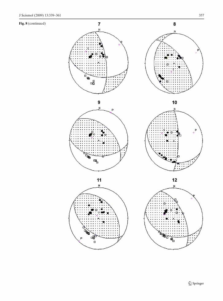
All these events are located in and around HKS(Fig. 3). P1, 3, 6, and 17 are situated in/near itswestern limb (Fig. 3). Structurally, the area is verycomplex. There exists the NS trending, steeplydipping left-lateral strike slip Jhelum Fault, alongwith MBT and Punjal Thrust (Fig. 3). These struc-tures are thin-skinned; no known deeper structurehas so far been documented from or near theepicentral location. The only major subsurfacestructure occurring in the core of the syntaxis, butat some distance, is the BBF. According to Khanand Ali (1994), based on gravity data, a NW–SEtrending steeply dipping (NE direction) basementfault extends to the Moho from a depth of about18 km. Focal depth of P1 at 65 km suggests ac-tivity in the crystalline basement (the total thick-ness of crust here has been estimated by them as58 km). FMS 3, 6, and 17 occurred at 10-km depth(Table 1). All these solutions are thrust in naturewith some minor right-lateral strike slip compo-nent, except P1, which has a minor left-lateralstrike slip component (Fig. 8). Considering thestrike (NW–SE), dip (NE), sense of slip (thrust),and depth (10 km) of FMS 3, 6 and 17, it isproposed that the IKSZ was activated.
The events P3, 1, 7, and 15 are situatedwithin the HKS and P9, 8, and 11 at its easternlimb (Fig. 3). FMS 3, 6, 7, 15, 17, and 11 are

348 J Seismol (2009) 13:339–361
shallow earthquakes with focal depths of 5–10 km,whereas P3 and P9 are of 54 and 43-km depth,respectively (Table 1). The latter two provide fur-ther evidence of the involvement of the crystallinebasement of a crust thickened to about 58 km.Thrust solutions with NW–SE striking ruptureplane have been obtained for all the events in-cluding FMS 1, which is for the October 8, 2005Muzaffarabad earthquake. Considering the trendand dip direction of the Bagh Basement Fault,the plane dipping NE at 26◦ is inferred to be therupture plane for P3 and P9. This suggests theexistence of more than one basement fault inthe core of the syntaxis. Probably, more detailedgravity modeling would help in providing informa-tion about their existence.
7 Depth analysis
As already mentioned, the 423 aftershocks havebeen considered within a 200 × 200-km area(Fig. 2) for the primary analysis. In order toinvestigate further the relationship between theIKSZ and Muzaffarabad earthquake using these423 aftershocks, the following depth analyses(Fig. 8a, b) have been done: (1) surface con-tour map of depth, (2) vertical projection of the17 FMS along a 100-km-wide northeast trendingstrip of Armbruster et al. (1978) modified byBilham (2005), and (3) about 130-km-wide and160-km-long parallel cross-section along the IndusKohistan seismic zone.
The surface contour depth map of the studyarea (Fig. 6a) has been prepared using the 423aftershocks. The contouring of depth usually in-volves some extrapolation, which may yield mis-leading results. In the present case, the depthsof the individual aftershock, highlighted by threecolors (Fig. 6a), have also been plotted on themap in order to overcome this problem. The NW–SE trending aftershocks (following the trend ofIKSZ) dominantly show a zone of shallower depthof 0–20 km (green color) for most of the events(90%). This is in conformity with the depth ofIKSZ. Further, a total of six cross-sections (5 kmwide) have been made within 130 × 160 km (i.e.,the area of NW–SE trending concentration ofaftershocks). Three of these lines (AB, CD, EF)
have been taken as perpendicular to this zone,whereas the remaining three (GH, IJ, KL) areparallel to it (Fig. 6a). The depth sections alongthese six lines are thus prepared (Fig. 6a). The twoalong the lines CD and GH are the representativeof the area of maximum concentration along thisNW–SE trending zone (i.e., a total of 273 after-shocks). They clearly indicate the activation ofIKSZ within the depth of 10 km (Fig. 6a).
In addition, the FMS of 17 earthquakes(Muzaffarabad earthquake and its aftershocks)have also been drawn on the vertical cross-sectionalong a 100-km-wide northeast trending strip ofArmbruster et al. (1978) modified by Bilham(2005), as shown in Fig. 8b. The distribution of17 FMS on this cross-section exactly lies on theIKSZ. The NW–SE striking and NE dipping thrustplanes are in consistency with the trend and dipdirection of this thrust wedge (IKSZ).
8 Fault rupture identification by correlatingfield studies, SAR data and FMS
In the NW Himalayas, prior to 2005, there is noreport of surface rupture on a causative fault ofany earthquake (Thakur 2006). Thus, one mayconclude that the NW Himalayan earthquakesare due to a blind fault zone, such as the IKSZ.However, the Muzaffarabad earthquake is thefirst of its kind to show the surface rupture of2- to 5-m displacement (Kaneda et al., submittedto BSSA). This has been observed through thefield studies (Kausar et al. 2006; Baig 2006; Zare2006; Zare et al. 2008) and SAR data (Fujiwaraet al. 2006). The 80- to 90-km-long rupture zonepasses through Balakot, Muzaffarabad, Rajkandi,Sarain, and Suddangali and dies out in the NW ofBalakot and SE of Suddangali towards Bagh (Baig2006). Zare (2006), however, reported evidencesof rupture even in Bagh, extending the total lengthto 120 km between Balakot and Bagh.
Kausar et al. (2006) noted the surface rup-ture to be about 80-km length, with maximumand mean vertical separation of 7 and 3 m, re-spectively. Fujiwara et al. (2006) analyzed theSAR data from the European space agency.From ground deformation, they concluded thatcrustal deformation occurred as results of the

J Seismol (2009) 13:339–361 349
Muzaffarabad earthquake in a NW–SE trending90-km-long strip (Fig. 5). In this figure, six FMSlie on the hanging wall of the Balakot–Bagh fault,nine FMS occupy the IKSZ, and two FMS areto the south. The FMS data suggest a seismo-genic zone trending NW–SE coinciding with theIKSZ. The IKSZ appears to represent north-west continuation of the Main Himalayan seis-mic zone extending from Nepal through Kumaon,Kangra, and Kashmir. Our field studies in BandiKarim Shah, Chilla Bandi, Rajkandi, Hattian Bala(Fig. 4) provides for a surface rupture of about90 km between the Balakot and Bagh, with meanvertical separation of 3–4 m right-lateral slip(Fig. 4).
As mentioned earlier, there are two NW–SEtrending structures in the area: the subsurfaceIndus Kohistan seismic zone and the 60-km-longMuzaffarabad Thrust or Balakot–Bagh Faultstretching from Balakot to Muzaffarabad and fur-ther on to Uri in India (Fig. 5). The SAR datashow the surface deformation and is measured incentimeters as a function of change in the lengthalong radar line of site from the ground positionto the SAR satellite (Fig. 5). Muzaffarabad andBalakot, the areas of maximum damage, show thehighest values in terms of displacement in theSAR data (Fig. 5). On the basis of the alignment ofaftershocks (Fig. 5) with the maximum deforma-tion identified in the SAR data, one may suspect
Fig. 4 Field evidences of rupture. a, b, and d are fromRajkandi, and c from Muzaffarabad. a, b Closely spacedlongitudinal cracks on a hillside, mostly perpendicular tothe master fault (Balakot–Bagh Fault, not shown in thephotographs). c, d Further away from the master fault, the
cracks are wider (up to 4.3 m) and several meters deep.In d, the right lateral is marked by the red arrows, alongwith vertical slip (120 cm) marked by small arrow. Insetshows the same right-lateral displacement displayed by thedislocation and twist in the roots of a tree

350 J Seismol (2009) 13:339–361
Fig. 5 Correlation of 17 FMS, active faults, and synthetic aperture radar (SAR) data of Fujiwara et al. (2006) for thecausative fault identification
that the BBF is the causative fault (Fujiwara et al.2006; Thakur 2006; Kausar et al. 2006). On theother hand, we propose that (1) IKSZ is the realcause of the Muzaffarabad earthquake and (2) theIKSZ further reactivated the existing BBF. Thisidea is supported by the distribution of the after-shocks, with major concentration further to thenorth of this fault where IKSZ exists (Fig. 2), theirfocal depths (as most of them are of 10–30 km. It isworth keeping in mind that none has reported thedownward extension of the BBF to this depth),and also the focal mechanism solutions of theaftershocks (which are dominantly NW–SE trend-
ing thrusts, again the dominant characteristics ofIKSZ, Fig. 3). Further, we have found that similarNW–SE thrust (FMS 1, 6, 7, 8, 11, 15, and 17)occurred within and on the periphery of the HKS(Fig. 3). The BBF is a thrust accompanied onsome right-lateral strike slip motion, which is alsoreflected. Previously, it was believed that IKSZends at the nose of HKS, but our FMS data indi-cate its probable southeast extension even insidethe syntaxis. This can further be confirmed byhaving more FMS data from the large numberof aftershocks of the Muzaffarabad earthquake.Parsons et al. (2006) calculated the stress changes

J Seismol (2009) 13:339–361 351
a
A B C D
E F G H
Fig. 6 a Surface contour depth map with six NW–SE andNE–SW trending 5-km-wide strips within the 130 × 160-kmarea (along the IKSZ) and their respective depth sections.b The vertical projection of the 17 FMS of Muzaffarabad
earthquake on the 100-km-wide northeast trending cross-section of Armbruster et al. (1978) modified by Bilham(2005). Events 4, 6, 7, 8, 10, 13, 14, 15, 16 are clusteredbetween 3 and 5

352 J Seismol (2009) 13:339–361
b
I J K L
Fig. 6 (continued)
with the Muzaffarabad earthquake on a slippingdislocation in an elastic half space. They mod-eled the stress-increased zones near and off theends of rupture between Balakot and Bagh anddecrease in stress to the south in the direction ofRawalpindi–Islamabad.
9 Distribution of landslides and destructionin the area
About 100 large landslides were formed in thearea due to ground shaking and gravity collapse(Fig. 7a–d). The area shown in Fig. 7b is thecentral inset of Fig. 7a. This clearly indicates thatmost of the large-scale landslides occurred in thenorth and northwest of Muzaffarabad. The closerview of some of these large-scale landslides nearMuzaffarabad is shown in Fig. 7c, d. It is worth
noting that the majority of them are located alongactive faults (Fig. 7e). The northwest trendingand southwest dipping linear active landslides arecommon in the hanging (more) and footwall of theBBF (Fig. 7e). The earthquake caused several sur-face ruptures in the epicentral region that inter-rupted the major roads and therefore caused greatdifficulties in relief work. The landslides were ofdifferent types, i.e., debris slides, rock falls, androck blocks. In Balakot, entire soil cover from thehillside has apparently slid. The greatest landslide,reported from the vicinity of Bagh, has dimensionsof about 2 × 3 km.
The earthquake caused widespread destructionin Muzaffarabad, Bagh, Rawalakot, Mansehra,Balakot, Abbottabad, Allai, and Batagram (Fig.7f–h). About 70% of the fatalities from the earth-quakes were caused by the collapse of buildingsand mostly by the collapse of weak masonry

J Seismol (2009) 13:339–361 353
Fig. 7 Landslides (a–e; courtesy of National Engineering Services Pakistan) and destruction (f–h) in Muzaffarabad andBalakot

354 J Seismol (2009) 13:339–361
Fig. 8 Focal mechanismsolutions (FMS) ofa) pre- (P1, P2, P3, etc.)and b) post- (1, 2, 3, etc.)Muzaffarabad earthquake
a

J Seismol (2009) 13:339–361 355
Fig. 8 (continued)
356 J Seismol (2009) 13:339–361
Fig. 8 (continued) b
J Seismol (2009) 13:339–361 357
Fig. 8 (continued)

358 J Seismol (2009) 13:339–361
Fig. 8 (continued)
J Seismol (2009) 13:339–361 359
buildings (adobe, rubble stone, etc.). These build-ing types are very common in Northern Pakistan(Fig. 7f–h). Most of the buildings are of stone, soil,and timber and single storey. They have a heavymud roof supported on unshaped timber with asmoke hole. Modern houses close to the majorroads, on the other hand, are of concrete blocksbut poorly designed and constructed. There is aneed to set up training program for builders tohelp them understand the proper use of modernbuilding materials.
10 Discussion
The active deformation of northern Pakistan is theresult of collision between the Eurasian and Indianplates, which is mainly accommodated alongEW trending MMT, MBT, and NW–SE trendingHKS. The October 8, 2005 Muzaffarabad earth-quake is the deadliest of all the Himalayan earth-quakes. Historical (Oldham 1893; Ambraseyset al. 1975; Quittmeyer et al. 1979) and instrumen-tal data (Fig. 4) suggest that this earthquake oc-curred in the region where seismic activity is veryhigh. MonaLisa et al. (2004b) estimated the peakground acceleration value of 0.47 g for the site ofMuzaffarabad based upon a deterministic seismichazard assessment prior to the earthquake, whichis quite high.
In this study, an attempt was made to inves-tigate the causative fault of this earthquake. Forthis, we deployed the aftershock data of 251 relo-cated events for the evaluation of the seismicitypattern and the main and 16 aftershocks for anunderstanding of the tectonics using FMS andsurface rupture analysis (using field studies andSAR data of Fujiwara et al. 2006). In addi-tion, 12 FMS of pre-Muzaffarabad earthquake(1904–2004) were also determined. From the de-tailed analysis of the 29 FMS (both pre- andpost-Muzaffarabad Earthquake) in relation to thestructure and tectonics of the area, three im-portant conclusion can be drawn: (1) Shallowevents (depth ≤10 km) with prominent strikeslip solutions (P10, P11, P12) are associatedwith the surface strike slip faults (e.g., BBF)and/or due to the uplifting of the Besham do-mal structure; (2) moderate depth events (depth
10–25 km) with thrust/reverse solutions but hav-ing minor right-lateral strike slip component (allMuzaffarabad earthquakes and P6, P7) are as-sociated with IKSZ; and (3) deeper earthquakes(depth below IKSZ) with pure thrust/reverse so-lutions may be related with the under-thrusting ofthe Indian plate beneath the IKSZ, which repre-sents a major thrust zone.
The FMS of 16 aftershocks and theMuzaffarabad earthquake are strongly suggestiveof a NW–SE trending, NE dipping thrust fault,about 90 km in length. Some 35 km of this pro-posed fault follows the NW–SE trending Balakot–Bagh Fault (Figs. 3 and 5). The remaining portionof the fault extends beyond the HKS, towardsthe MMT, through the crystalline nappe zonewhere the presence of the BBF has not beenreported. The main shock occurred within theHKS, whereas the major concentration of theaftershocks lies between the HKS and MMT(Figs. 2 and 3). We therefore propose that theIKSZ is seismically active and was the source ofthe Muzaffarabad earthquake. This is also evi-dent by the occurrence of the second strong-est earthquake of the area, known as 1974Pattan earthquake, having magnitude of 6.0and focal depth of 15 km. The FMS of thisearthquake is also a NW–SE striking thrustwith minor right-lateral strike slip component.Pennington (1979), following Armbruster et al.(1978), proposed that the IKSZ extends fromthe MMT (near Pattan) to the edge of the HKS.The present study shows that the IKSZ extendsfurther southeast into the center of syntaxis. Theright-lateral strike slip motion (although minor),as indicated by all 17 FMS, has also been observedin the field (Fig. 4b, d). The correlation of SARdata of Fujiwara et al. (2006) and stress patternof Parsons et al. (2006) with the 17 FMS dataand active faults in the area clearly indicates theareas of maximum crustal deformation (Fig. 5),stresses, and the nature of IKSZ. The FMS ofMuzaffarabad earthquake and its aftershocks areconsistent with those of the previous earthquakesof IKSZ.
As mentioned earlier, IKSZ is a wedge-shapedNW–SE trending blind zone. The geometry ofthis blind zone is elaborated by Seeber andArmbruster (1979) by configuring this zone into

360 J Seismol (2009) 13:339–361
NE dipping lower and horizontal upper limbs.According to them, this wedge is a front of a slabmoving towards the south west with respect to therock layers above and below it (Fig. 6b). IKSZrepresents the reactivation of decollement surfaceand have short-term stress field which may causethe broad zone of scattered seismicity as observedin the present study.
As mentioned earlier, none of the NWHimalayan earthquakes in Pakistan has shownevidences of surface rupture. In contrast, theMuzaffarabad earthquake shows surface rupturefor about 90 km between Bagh and Balakot, withmean vertical separation of 3- to 4-m right-lateralslip (Fig. 6). This is in good agreement with thesurface rupture reported from the area by earlierworkers (Kaneda et al., submitted; Zare 2006;Baig 2006; Kausar et al. 2006). The maximumdamage occurred in the epicentral region and NWof it, which coincides with the aftershocks loca-tions. It seems that the majority of the ruptureoccurred in the eastern part of IKSZ (Fig. 5) andinvolved only a small part of the syntaxis. SinceArmbruster et al. (1978) and Seeber et al. (1981)suggested that IKSZ is buried at a depth of 10 kmand does not extend to the surface, therefore,the damage was also caused by shallow faulting(BBF).
The Muzaffarabad earthquake is not only thedeadliest of all the Himalayan earthquakes butit may also have triggered the largest number oflandslides (more than 100) in the area. Most oc-curred along the active faults, whereas NW trend-ing linear landslides are observed more commonlyin the hanging wall of the BBF (Fig. 7a–e).
It is suggested that mapping of the active faultsthrough palaeoseimological studies, field investi-gations, and high-resolution air photos and satel-lite images may help in better understanding ofthe kinematic changes taking place in the area.This may be further improved by measuring therelative displacement using global positioning sys-tem along these faults. SAR data may also proveto be a good supplement for the identificationof critical fault zones. Finally, a better coverageof seismic stations along these critical fault zoneswill add substantially to our understanding ofthe kinematic changes taking place in the area(Fig. 8).
Acknowledgements Thanks are due to Yawer S. Ansariof National Engineering Services Pakistan for satellite im-ages. The provision of data from the local observatories isalso gratefully acknowledged. This work is partially sup-ported by Higher Education Commission (HEC) ProjectsNo. 20-749/R & D/07/336 and 20-600/R & D /06/1761.
References
Ambraseys NN, Lensen G, Monifer A (1975) ThePattan earthquake of 28 December 1974. UNESCOpublications
Arif M, Jan MQ (2006) Petrotectonic significance of thechemistry of chromite in the ultramafic-mafic com-plexes of Pakistan. J Asian Earth Sc 27:628–646
Armbruster JG, Seeber L, Jacob KK (1978) The north-west termination of the Himalayan mountain front:active tectonics from micro earthquakes. J GeophysRes 83:269–282
Avouac JP, Ayoub F, Leprince S, Konca O, HelmbergerDV (2006) The 2005, Mw 7.6 Kashmir earthquake:sub-pixel correlation of ASTER images and seis-mic waveform analysis. Earth Planet Sci Lett 249:514–528
Baig MS (2006) Active faulting and earthquake defor-mation in Hazara–Kashmir Syntaxis, Azad Kashmir,Northwest Himalaya, Pakistan. In: Extended abstracts,international conference on earthquake in Pakistan:its implications and hazard mitigation. Islamabad,pp 21–22, 18–19 Jan 2006
Baig MS, Lawrence RD (1987) Precambrian to earlyPaleozoic orogenesis in the Himalayas. KashmirJ Geol 5:1–22
Baig MS, Snee LW, La Fortune RJ, Lawrence RD(1989) Timing of pre-Himalaya: 40Ar/39Ar constraints.Kashmir J Geol 6/7:29–40
Bilham R (2005) A flying start followed by slow slip.Science 308(5725):1126
Chandra U (1975) Fault plane solutions and tectonicimplications of the Pattan Pakistan earthquake ofDecember 28, 1974. Tectonophysics 6:T19–T24
Fujiwara S, Tobita M, Psato H, Ozawa S, Une A,Fujiwara M, Yarai H, Nishimura T, Hayashi F (2006)Satellite data give snapshot of the 2005 Pakistanearthquake, EOS. Trans Am Geophys Union 87(7):73–84
Gahalaut VK (2006) 2005 Kashmir earthquake: not aKashmir Himalaya seismic gap event. Curr Sci 90(4):507–508
Garrido CJ, Bodinier JL, Burg JP, Zeilinger G, Hussain SS,Dawood H, Chaudhry MN, Gervilla F (2006) Petro-genesis of mafic garnet granulite in the lower crust ofthe Kohistan Paleo-arc complex (Northern Pakistan):implications for intra-crustal differentiation of IslandArcs and generation of continental crust. J Petrol47(10):1873–1914

J Seismol (2009) 13:339–361 361
Gee ER (1980) Overview of the geology and structure ofthe Salt Range, with observations on related areas ofnorthern Pakistan. In: Malinconico LL, Lillie RJ (eds)Tectonics of the western Himalayas. Geol Soc Am,Special Paper, 232, pp 95–112
Hussain A, Yeats RS (2002) Active faulting in the southernPeshawar basin, Pakistan. Geol Bull Univ Peshawar35:113–124
Hussain A, Dipietro JA, Pogue KR, Ahmad I (2004) Geo-logical map of the 43B degree sheet, NWFP, Pakistan.Geological Survey of Pakistan, Quetta
Hussain A, Yeats RS, MonaLisa (2008) Geological settingof the 8 October 2005 Kashmir Earthquake. J Seismoldoi:10.1007/s10950-008-9101-7
Jan MQ, Rafiq M (2007) Petrology of chloritoids-illmenite-rich rocks in the Indus Suture mélange ofPakistan: implications for the cretaceous paleolatitudeof Kohistan. J Asian Earth Sci 29:361–368
Kausar AB, Hussain SH, Kaneda H, Kondo H, Awata Y,Jouanne F (2006) Hazara Kashmir Syntaxis seismichazard of October 8, 2005 earthquake. In: Abstract,International workshop on seismology, seismotecton-ics and seismic hazard in the Himalayan region, p 21
Kazmi AH, Jan MQ (1997) Geology and tectonics ofPakistan. Graphic Publishers, Karachi, Pakistan,545 pp
Khan MR, Ali M (1994) Preliminary modeling of the west-ern Himalaya. Kashmir J Geol 11–12:59–66
Khurshid A, Yielding G, Ahmad S, Davison I, Jackson JA,King GCP, Guo LB (1984) The seismicity of northern-most Pakistan. Tectonophysics 109: 209–226
MonaLisa (in press) Recent seismic activity in the NW Hi-malayan Fold and Thrust Belt, Pakistan: focal mech-anism solution and tectonic implications. GeologicalSociety of London, special publications.
MonaLisa, Khan SA, Khwaja AA (2004a) Focal mecha-nism studies of North Potwar deformed zone (NPDZ),Pakistan. Acta Seismol Sinica 17(3):255–261
MonaLisa, Khwaja AA, Chaudhry QZ (2004b) Estimationof peak horizontal accelerations for the site of Muzaf-farabad using deterministic approach. Pak J Meteorol1(2):19–33
MonaLisa, Kausar AB, Khwaja AA, Jan MQ (2006)October 8, 2005, Pakistan earthquake: preliminary ob-servations and report of an International ConferenceIslamabad, Pakistan January 18–19, 2006. Episodes20(1):5–7
MonaLisa, Khwaja AA, Jan MQ (2007) Seismic hazardassessment of the NW Himalayan fold-and-thrust belt,Pakistan using probabilistic approach. J Earthqu Eng11:257–301
MonaLisa, Khwaja AA, Jan MQ (2008) October 08,2005 Muzaffarabad earthquake: seismological inves-tigations and probabilistic estimation of peak groundaccelerations. Curr Sci 94(9):1158-1166
Nakata T, Tsutsumi H, Khan SH, Lawrence RD (1991)Active faults of Pakistan: map sheets and inventories:special publication, vol 21. Research Center for Re-gional Geography, Hiroshima University, Hiroshima,Japan, 141 p
Ni J, Ibenbrahim A, Rocker SW (1991) 3 Dimensionalvelocity structure and hypocenters of earthquakesbeneath the Hazara arc, Pakistan: geometry of theunderthrusting Indian plate. J Geophys Res 96(19):865–877
Oldham T (1893) A catalogue of Indian earthquakes. MemGeol Survey, India
Parsons T, Yeats RS, Yagi Y, Hussain A (2006) Static stresschange from the 8 October, 2005 M = 7.6 Kashmirearthquake. Geophys Res Lett 33:1–4
Pennington WD (1979) A summary of field and seis-mic observations of Pattan earthquake. In: Farah A,DeJong KA (eds) Geodynamics of Pakistan. Geo-logical Survey of Pakistan, Pakistan, pp 143–147
Quittmeyer RL, Farah A, Jacob KH (1979) The seismic-ity of Pakistan and its relation to surface faults.In: Farah A, DeJong KA (eds) Geodynamics ofPakistan. Geological Survey of Pakistan, Quetta, pp271–284
Searle MP, Khan MA (eds) (1996) Geological map of northPakistan. Oxford University Press, Oxford
Seeber L, Armbruster J (1979) Seismicity of Hazara Arcin Northern Pakistan: decollement vs. basement fault-ing. In: Farah A, DeJong KA (eds) Geodynamicsof Pakistan. Geological Survey of Pakistan, Quetta,pp 131–142
Seeber L, Quittmeyer RC, Armbruster JG (1981) Seismo-tectonics of Pakistan: a review of results from networkdata and implications for the central Himalayas. GeolBull Univ Peshawar 13:151–168
Sercombe WJ, Pivnik DA, Wilson WP, Albertin ML,Beck RA, Stratton MA (1998) Wrench faulting in thenorthern Pakistan foreland. AAPG Bull 82:2003–2030
Suetsugu D (1997) Source mechanism practice. In: Train-ing course in seismology and earthquake engineeringII. Japan international cooperation agency (JICA),Ibaraki-ken 305 Japan, pp 13–48
Thakur VC (2006) Lesson learnt from the 8 October 2005Muzaffarabad earthquake and need for some initia-tives. Curr Sci 91(5):566
Treolar PJ, Broughton RD, Williams MP, Coward MP,Windley BF (1989) Deformation, metamorphism andimbrication of the Indian plate south of the MainMantle Thrust, North Pakistan. J Metamorph Geol7:111–125
Wadia DN (1931) The syntaxis of the northwest Himalaya:its rocks, tectonics and orogeny. Geol Surv India Rec63(1):129–138
Zare M (2006) The Balakot Pakistan earthquake of 8October 2005, Mw 7.6: the seismological aspects andfield observations. In: Extended abstracts, Interna-tional Conference on Earthquake in Pakistan; Its im-plications and hazard mitigation. Islamabad, pp 32–33,18–19 Jan 2006
Zare M, Karimi-Paridari S, MonaLisa (2008) Aninvestigation on Balakot, Muzaffarabad (Pakistan)Earthquake, 8 Oct. 2005, Mw 7.6; geological aspectsand intensity distribution. J Seismol doi:10.1007/s10950-008-9120-4