Embed Size (px)
Citation preview

Intended for
Bugesera Airport Company Limited
Date
December 2018
Project Number
UK11-24483
NEW BUGESERA INTERNATIONAL AIRPORT ENVIRONMENTAL AND SOCIAL IMPACT ASSESSMENT REPORT – VOLUME 1 ESIA MAIN REPORT
NEW BUGESERA INTERNATIONAL AIRPORT ENVIRONMENTAL AND SOCIAL IMPACT ASSESSMENT REPORT – VOLUME 1 ESIA MAIN REPORT
Ramboll Environ Artillery House 11-19 Artillery Row London SW1P 1RT United Kingdom T +44 207 808 1420 www.ramboll-environ.com
Project No. UK11-24483 Issue No. 3 Date 13/10/2017 Made by Brent Holme/Sheenagh Mann/Marylise
Schmid/Technical Authors Checked by Brent Holme/Denise Wright Approved by Denise Wright
Made by: Checked/Approved by:
This report has been prepared by Ramboll Environ with all reasonable skill, care and diligence, and taking account of the Services and the Terms agreed between Ramboll Environ and the Client. This report is confidential to the Client, and Ramboll Environ accepts no responsibility whatsoever to third parties to whom this report, or any part thereof, is made known, unless formally agreed by Ramboll Environ beforehand. Any such party relies upon the report at their own risk. Ramboll Environ disclaims any responsibility to the Client and others in respect of any matters outside the agreed scope of the Services. Version Control Log
Revision Date Made by Checked by Approved by Description
3 13/10/17 BH/SM/MS BH/DW DW Final Issue

Environmental and Social Impact Assessment Report – Volume 1 ESIA Main Report New Bugesera International Airport
CONTENTS
ABBREVIATIONS 1 1. INTRODUCTION AND BACKGROUND 1 1.1 Introduction 1 1.2 Proposed Project Objectives 1 1.3 Overview of the Proposed Project 1 1.4 Definition of Terms Used in the Report 4 1.5 Objectives of the ESIA 6 1.6 Scope of the ESIA 6 1.7 Proposed Project Proponent/Developer 6 1.8 Environmental Impact Assessment Team 7 1.9 REMA Requirements of EIA/ESIA 8 1.10 Report Structure 10 2. POLICY, LEGAL AND ADMINISTRATIVE FRAMEWORK 13 2.1 Introduction 13 2.2 National Legal and Administrative Requirements 13 2.3 International Standards, Guidelines and Treaties/Conventions 26 2.4 International Financial Institution Standards 26 2.5 Corporate Requirements 28 3. IMPACT ASSESSMENT METHODOLOGY 29 3.1 Introduction 29 3.2 ESIA Process 29 3.3 Cumulative Impacts 41 3.4 Environmental and Social Management 42 3.5 Stakeholder Engagement 42 3.6 Assumptions and Limitations 43 4. ANALYSIS OF ALTERNATIVES 44 4.1 Introduction 44 4.2 The Need for a New Airport 44 4.3 Alternative Modes of Transportation 45 4.4 Alternative Locations 45 4.5 No Action Alternative 45 4.6 Alternative Designs 46 5. DEVELOPMENT CONTEXT 48 5.1 Area Overview 48 5.2 Site Description 48 5.3 Environmental Setting 49 5.4 Socio-Economic Setting 51 5.5 Definition of the Proposed Project Area of Influence and Sub-Areas of
Influence 51 6. PROPOSED PROJECT DESCRIPTION 55 6.1 Introduction 55 6.2 Proposed Project Phasing 56 6.3 Description of Proposed Project Facilities, Components and Activities
57 6.4 Construction Phase 69 6.5 Operation Phase 76 6.6 Closure and Decommissioning 79

Environmental and Social Impact Assessment Report – Volume 1 ESIA Main Report New Bugesera International Airport
LIST OF TABLES
Table 1-1: Proposed Project Proponent/Developer Details ................................................. 7 Table 1-2: Environmental Impact Assessment Team ........................................................ 7 Table 1-3: REMA Requirements .................................................................................... 8 Table 3-1: Impact Types ............................................................................................ 34 Table 3-2: Impact Magnitude Factors .......................................................................... 35 Table 3-3: Impact Magnitude ..................................................................................... 36 Table 3-4: Impact Significance Matrix .......................................................................... 37 Table 3-5: Impact Significance Definitions .................................................................... 37 Table 3-6: Evaluation of Impact Significance: Example Table .......................................... 39 Table 3-7: Likelihood Categories for Unplanned Events................................................... 41 Table 5-1: Sub-Areas of Influence ............................................................................... 53 Table 6-1: Master Plan Development Phases ................................................................. 56 Table 6-2: Airport Support Facilities during the Life of the Proposed Project ...................... 77 Table 6-3: Airport Parking Areas and Lots .................................................................... 77 Table 6-4: Apron Area Requirements ........................................................................... 78 Table 6-5: Forecasted Aircraft Movements during the Life of the Proposed Project .............. 78 Table 6-6: Estimated Airport Operations AADT for the Expressway per Phase .................... 79 Table 6-7: Estimated Airport Operations Peak Hour Values for the Expressway per Phase .... 79 LIST OF FIGURES
Figure 1-1: Site Location of the Proposed Development .................................................... 3 Figure 1-2: Terms of Use (Source: Google Earth Pro, 2012) .............................................. 5 Figure 3-1: ESIA Process ........................................................................................... 30 Figure 3-2: Impact Evaluation Framework Process ......................................................... 34 Figure 3-3: Mitigation Hierarchy .................................................................................. 40 Figure 5-1: Airport Area Photos .................................................................................. 49 Figure 6-1: Cross Section of the Passenger Terminal ...................................................... 57 Figure 6-2: Cross Section of the General Aviation Terminal ............................................. 58 Figure 6-3: Cross Section of the Presidential Terminal Building ........................................ 58 Figure 6-4: Typical Fuel Pit System ............................................................................. 62 Figure 6-5: Fuel Pit Main Apron ................................................................................... 63 Figure 6-6: Expressway Cross-Section ......................................................................... 64 Figure 6-7: Expressway Route (Source: BAC, 2017) ...................................................... 65 Figure 6-8: Proposed Fencing ..................................................................................... 66 Figure 6-9: Construction Schedule .............................................................................. 70 Figure 6-10: Location of Construction Camp ................................................................. 73 Figure 6-11: Road from Kigali to the Construction Camp ................................................ 74 Figure 6-12: Illustration of Borrow Pits and Spoil Areas within the Airport Footprint ............ 75

Environmental and Social Impact Assessment Report – Volume 1 ESIA Main Report New Bugesera International Airport
ABBREVIATIONS
Abbreviation Definition
AADT Annual Average Daily Traffic
ACV Airport Design Management: Airport Consulting Vienna
AEDT Aviation Environmental Design Tool
AES Audio encounter surveys
AF Associated Facility
AFC Africa Finance Corporation
AfDB ISS African Development Bank Integrated Safeguard System
AOD Above Ordnance Datum
AOI Area of Influence
APU Auxiliary power unit
ARFF Aircraft Rescue and Firefighting
BAC Bugesera Airport Company Limited
BAT Best available techniques
BCAS Bird Collision Avoidance System
BTC Rwanda Belgian Development Agency Rwanda
CAPEX Capital expenditure
CBD Convention on Biological Diversity
CBO Community-Based Organisation
CERC Cambridge Environmental Research Consultants
CH4 Methane
CHSS Community Health, Safety and Security
CIA Cumulative Impact Assessment
CO Carbon monoxide
CO2 Carbon dioxide
dB Decibel
DEFRA Department for Environment, Food and Rural Affairs
EA Environmental Assessment
E&S Environmental and Social
EDCL Energy Development Corporation Limited
EDPRS Economic Development and Poverty Reduction Strategy
EHS Environment, Health and Safety
EIA Environmental Impact Assessment
EPC Contractor Engineering, Procurement and Construction Contractor
ESAP Environmental and Social Action Plan
ESIA Environmental and Social Impact Assessment
ESMP Environmental and Social Management Plan

Environmental and Social Impact Assessment Report – Volume 1 ESIA Main Report New Bugesera International Airport
Abbreviation Definition
ESMS Environmental and Social Management System
ESSP Energy Sector Strategic Plan
ETL Electricity transmission lines
FAA Federal Aviation Authority
FI Financial Intermediary
GA General Aviation
GDP Gross Domestic Product
GHGs Greenhouse gases
GIIP Good International Industry Practice
GIS Geographic Information System
GOR Government of Rwanda
GPS Global Positioning System
GRC Grievance Review Mechanism
GSE Ground Service Equipment
H2S Hydrogen sulphide
ha Hectares
hrs Hours
IA Impact Assessment
IATA International Air Transport Association
IBA Important Bird/Biodiversity Area
ICAA International Civil Aviation Authority
ICAO International Civil Aviation Organisation
ICOMOS International Council on Monuments and Sites
IFC International Finance Corporation
IFC PS International Finance Corporation Performance Standards
ILS Instrument Landing System
INMR Institute of National Museum of Rwanda
ITCZ Intertropical Convergence Zone
IUCN International Union for Conservation of Nature
IWRM Integrated Water Resource Management
KfW Group German Development Bank
kg Kilogram(s)
KGL Kigali International Airport
KII Key Informant Interviews
km kilometres
LRP Livelihood Restoration Plan
LTO Landing and Take-Off
m Metre(s)

Environmental and Social Impact Assessment Report – Volume 1 ESIA Main Report New Bugesera International Airport
Abbreviation Definition
m3 Cubic metres
MAP Million annual passengers
masl Metres above sea level
mbgl Metres below ground level
MININFRA Ministry of Infrastructure
MINIRENA Ministry of Natural Resources
Mota-Engil Mota-Engil Engenharia e Construcão
MTOW Maximum take-off weight
NBIA New Bugesera International Airport
NSP National Strategic Plan
NTS Non-Technical Summary
N₂O Nitrous oxide
NEWPLAN NEWPLAN Limited
NGO Non-Governmental Organisation
NOx Nitrogen oxides
NSGRP National Strategy for Growth and Reduction of Poverty
OHTL Overhead transmission line
OD Operational Directive
PAPs Project Affected Persons
PET Polyethylene terephthalate
pH The pH of a solution indicates how acid or alkaline the solution is
PM10 and PM2.5 Particulate matter of 10 and 2.5 micrometres in size
POP Persistent Organic Pollutants
PPE Protective Personal Equipment
PPP public-private partnership
PPT PowerPoint
PS Performance Standard
PSDH Project for Sustainable Development of Heathrow
Ramboll Environ Ramboll Environ UK Limited
RAP Resettlement Action Plan
RCAA Rwanda Civil Aviation Authority
RDB Rwanda Development Board
REG Rwanda Energy Group
REMA Rwanda Environment Management Authority
RESA Runway End Safety Area
RFF Rescue and Firefighting
RFFS Rescue and Firefighting Services
RL Red List of Threatened Species

Environmental and Social Impact Assessment Report – Volume 1 ESIA Main Report New Bugesera International Airport
Abbreviation Definition
RLMUA Rwanda Land Management and Use Authority
RTDA Rwanda Transport Development Agency
RURA Rwanda Utilities Regulatory Authority
SEA Strategic Environmental Assessment
SEP Stakeholder Engagement Plan
SPIU Single Project Implementation Unit
SO2 Sulphur dioxide
T Time period
t Tonne(s)
ToR Terms of Reference
TRL Technology readiness level
TSP Total Suspended Particulates
UK United Kingdom
US EDMS model United States Emissions and Dispersion Modelling System
USCS Unified Soil Classification System
VEC Valuable environmental and social components
VES Visual encounter surveys
VIP Very Important Person
VOCs Volatile Organic Compounds
WASAC Rwanda Water and Sanitation Corporation
WHO World Health Organisation

Environmental and Social Impact Assessment Report – Volume 1 ESIA Main Report New Bugesera International Airport
1
1. INTRODUCTION AND BACKGROUND
1.1 Introduction
The Bugesera Airport Company Limited (BAC) is a joint venture between Mota-Engil Engenharia e Construcão (Mota-Engil) and the Government of Rwanda (GOR). BAC intends to develop a new international airport within the Bugesera District, in the Eastern Province of Rwanda, referred to as New Bugesera International Airport (the ‘Proposed Project’).
The potential financial lenders for the Proposed Project include organisations that apply international financial institution standards. These include the International Finance Corporation (IFC) Performance Standards, the Equator Principles and the standards of specific banks, such as the African Development Bank Integrated Safeguards System. Therefore, an Environmental and Social Impact Assessment (ESIA) is required to demonstrate that the Proposed Project complies with the relevant Project Standards that are to be adopted. This ESIA has been prepared for BAC by Ramboll Environment UK Limited (Ramboll Environ). It presents the potential environmental, social and community health impacts associated with the Proposed Project.
1.2 Proposed Project Objectives
The Proposed Project objectives are:
To replace the civil aviation function at Kigali International Airport (KGL), which is now operating at maximum capacity and will become a military airport;
To become the main airport for Kigali and gateway to Rwanda;
To become a regional hub for East Africa;
To develop the position of Rwanda as a business and tourism destination; and
To become a cargo hub for the region.
1.3 Overview of the Proposed Project
The Proposed Project is to be situated within the Rilima and Juru Sectors of the Bugesera District in the Eastern Province of Rwanda, as shown in Figure 1-1 and Figure 1-2. These main sectors are comprised of a number of cells, which in turn contain numerous villages. The airport will be approximately 23 km southeast of Kigali City, along the Kicukiro-Nyamata-Nemba KK-15 Road, which connects Rwanda to Burundi.
The Proposed Project will become Rwanda’s largest international airport, serving commercial flights destined to and from the greater Kigali metropolitan area and the wider country. When completed, it will become Rwanda’s third international airport and the country’s eighth airport overall. It will replace the existing civilian passenger capacity at Kigali International Airport (KGL), which will remain operational for military purposes.
The airport is proposed to be constructed in five phases, the first of which is due to be finalised by 2020 to allow the airport to become operational. The final phase is due to be completed in 2045. The Proposed Project will be financed by BAC as well as International Lenders.
The Proposed Project includes the development, construction and operation of the following structures and infrastructure, which will be delivered in five phases:
Airport and associated structures and infrastructure;
Temporary 5 km Water Pipeline for the construction phase;
Upgrades to the road linking an existing quarry northeast of the Proposed Project to the Airport Area for the supply of aggregates during construction; and

Environmental and Social Impact Assessment Report – Volume 1 ESIA Main Report New Bugesera International Airport
2
14.5 km Expressway to link the airport to the national KK-15 Road.
There will also be Associated Facilities1, which include the infrastructure for the permanent supply of power and water during the operation. The construction of these utilities and infrastructure will be the responsibility of the Rwanda Energy Group (REG) and The Rwanda Water and Sanitation Corporation (WASAC) respectively. Separate environmental and social impact assessments will need to be undertaken in accordance with the relevant legislative and regulatory standards. Additional information of the terms used throughout this ESIA Report in relation to the various designated areas is provided in the following Chapter 4.
The Airport Area comprises approximately 2,500 ha, which was previously used largely for subsistence farming. Additional information of the terms used throughout this ESIA Report in relation to the various designated areas is provided in Section 1.4.
1 As per the IFC PS1, Associated Facilities are facilities that are not funded as part of the project and that would not have been
constructed or expanded if the project did not exist and without which the project would not be viable.

Environmental and Social Impact Assessment Report – Volume 1 ESIA Main Report New Bugesera International Airport
3
Figure 1-1: Site Location of the Proposed Development

Environmental and Social Impact Assessment Report – Volume 1 ESIA Main Report New Bugesera International Airport
4
1.4 Definition of Terms Used in the Report
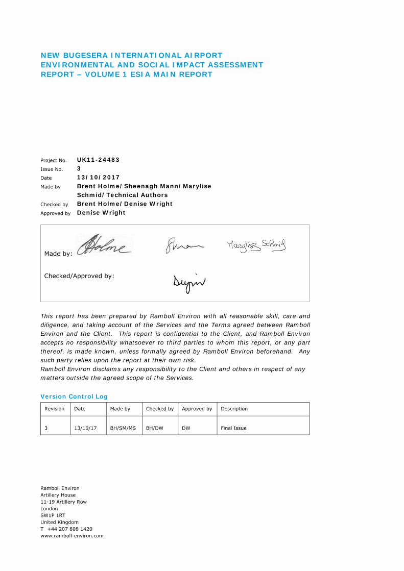
For the purposes of this Report, the following terms and definitions are used. Figure 1-2 provides an illustration of these areas.
Proposed Project Area: The Proposed Project Area contains all structures and infrastructure associated with the Airport Area, Construction Camp, Expressway, upgraded quarry road and temporary Water Pipeline during the construction phase.
Airport Area and Airport Footprint: The Airport Area, within the Proposed Project Area, will cover approximately 2,500 ha and the actual Airport Footprint will be approximately 360 ha within this. This Airport Footprint will comprise the runway, taxiways, aprons, helipads, terminals (presidential, passengers and general aviation), airplane hangars, cargo area, vehicle parking areas, ground service equipment, airport maintenance areas, rescue and firefighting services, control tower, fuel farm, wastewater treatment and waste management facilities.
Inhabitants and landowners within the Airport Area were resettled from 2010 onwards and they have been compensated and/or relocated/resettled offsite. This area is owned by the GOR and is currently being leased by BAC for an initial period of 99 years.
A Construction Camp has been constructed within the Airport Area to the south of the Airport Footprint and comprises site offices, laboratories, changing rooms, first aid station, vehicle parking and maintenance sheds, fuel tank area and water treatment plant. Prior to a waste treatment plant being constructed, septic tank systems will be utilised across the camp area. The Construction Camp covers an area of approximately 9 ha. No worker accommodation will be provided for employees or contractors at the Construction Camp or within the Airport Area. A small number of foreign nationals will be housed temporarily offsite in a lodge complex (Gashora Lodge).
Expressway: A new Expressway will be constructed to access NBIA. This route will be approximately 14.5 km in length from the north-western section of the Airport Area and link to the existing KK-15 Road providing direct access to Kigali. The Expressway will comprise a dual lane bitumen surfaced thoroughfare with a width of approximately 9 m that will be paved (one line in each direction – 3 m; paved shoulders 1.5 m each). The overall road reserve will be 44 m, although this will not be hard surfaced.
Water Pipeline: During the construction phase, a temporary aboveground 5 km Water Pipeline will be installed and will provide water during the construction activities from Lake Kidogo, located to the southeast of the Airport Area. Water from the pipeline will pass through a water treatment plant prior to being used onsite.
Quarry Road: The Proposed Project will make use of an existing quarry located approximately 10 km northeast of the Airport Area. An 18 km unpaved road is currently being used by heavy vehicles that pass through Kabukuba Village. An existing alternative route, also in use, has been earmarked to be widened and graded for use. This upgraded quarry road will bypass the centre of Kabukuba Village and reduce the overall length of the route to 10 km. The unsurfaced road will need to be widened at some areas and will be the responsibility of BAC to maintain. The route will remain unsurfaced.
Environmental and Social Impact Assessment Report – Volume 1 ESIA Main Report New Bugesera International Airport
5
Figure 1-2: Terms of Use (Source: Google Earth Pro, 2012)

Environmental and Social Impact Assessment Report – Volume 1 ESIA Main Report New Bugesera International Airport
6
1.5 Objectives of the ESIA
The objectives of this ESIA are to:
Facilitate an understanding of the elements of the existing baseline conditions that are relevant to resources/receptors that could be significantly impacted by the Proposed Project;
Identify the aspects of the Proposed Project likely to result in significant impacts to resources/receptors;
Determine and assess the significance of the impacts of the Proposed Project;
Identify the environmental, social, health and safety aspects of the Proposed Project that need to be managed and recommend appropriate and justified mitigation and enhancement measures;
Determine and evaluate the significance of residual impacts;
Document how stakeholders have been engaged during the ESIA Process, and how stakeholder feedback has been considered in the ESIA; and
Develop an Environmental and Social Management Plan Framework (ESMP Framework) to set out the links between the Environmental and Social Management System (ESMS), full ESMP and environmental and social sub-plans.
1.6 Scope of the ESIA
A Scoping Report was prepared at the commencement of the ESIA process to set out which environmental and social topics should be included in the assessment. The potentially significant environmental and social issues that were identified during the ESIA scoping process, and that have been addressed within this ESIA, are as follows:
Traffic and Transport;
Air Quality;
Noise and Vibration;
Biodiversity;
Water Resources;
Geology and Soils;
Archaeology and Cultural Heritage;
Landscape and Visual;
Waste Management;
Resource Efficiency;
Socio-economics, including Health and Safety; and
Cumulative Impacts.
For each of these topics, the impacts of the Proposed Project have been assessed during the construction phase, during Phase 1 of the operation phase (2020), when the Proposed Project will become operational, and during Phase 5 of the operation phase (2045), when the Proposed Project will be fully delivered.
1.7 Proposed Project Proponent/Developer
The contact details for BAC are provided in Table 1-1.

Environmental and Social Impact Assessment Report – Volume 1 ESIA Main Report New Bugesera International Airport
7
Table 1-1: Proposed Project Proponent/Developer Details
Proposed Project Proponent Information
Details
Proposed Project Applicant/ Developer
Bugesera Airport Company Limited
Company Registration Number 106575464
Contact Person Mr Maciej Michałek
Postal Address KG 415 Avenue, Gate Nº 6, Gacuriro P.O Box 2179 Kigali Rwanda
Telephone +250 781 447 482
Email [email protected]
1.8 Environmental Impact Assessment Team
The Ramboll Group comprises a staff of 13,000 people in 300 offices in 35 countries. Within the Group, the Ramboll Environ network of environment and health experts includes more than 2,100 employees. Our Impact Assessment Services team, based in Africa, the Americas, Asia Pacific, Europe and the Middle East regions, has experience across a range of sectors, particularly in major infrastructure development, power, oil and gas, and mining, and is conversant in International Financial Institution standards.
Ramboll Environ is being supported on the ESIA by NEWPLAN Limited (NEWPLAN) who is recognised and authorised by Rwanda Environment Management Authority (REMA) to undertake EIA/ESIA work in Rwanda and included on their list of approved consultants. NEWPLAN is a multidisciplinary engineering and consultancy established in 1995. The company’s service areas include infrastructure, energy, oil and gas, architecture, environment and social, development, surveys and project management training. The company has 32 professional permanent employees and draws on a network of professionals within its various fields of operation.
Ramboll Environ and NEWPLAN contact details are provided in Table 1-2.
Table 1-2: Environmental Impact Assessment Team
Environmental Practitioner Ramboll Environ NEWPLAN
Environmental Practitioner Ramboll Environ UK Limited NEWPLAN Limited
Company Registration Number 2331163 29560
Contact Person Mrs. Denise Wright Mr. Simon Muliisa
Postal Address Artillery House 11-19 Artillery Row London SW1P 1RT United Kingdom
Ground Floor, Blue Star House Box 167 Kigali
Rwanda
Telephone +44 7850 655736 +250 787 313 211/ +256 793 852 832

Environmental and Social Impact Assessment Report – Volume 1 ESIA Main Report New Bugesera International Airport
8
1.9 REMA Requirements of EIA/ESIA
The following table summarises REMA’s requirements when undertaking an EIA/ESIA report and the associated sections where the requirements are contained within this ESIA Report.
Table 1-3: REMA Requirements2
REMA Requirements Reference in this ESIA Report
Executive summary of the EIA/ESIA Report “which should be brief and focus on the following matters: Name and location of the project; Name of the developer; Name of the agency preparing the EIA/ESIA report; Main impacts identified; Mitigation recommendations; Environmental monitoring plan.”
Non-Technical Summary (NTS)
Objectives of the project, “including ideas, intentions and particular objectives”
Volume 1: ESIA Main Report Section 1.2 Proposed Project Objectives
Description of the proposal and its alternatives The following are the required contents of the section: “The stage of the project cycle where the project is being
implemented (pre-feasibility study, feasibility study or design)
Outlines of the plan for impact prediction and mitigation measures;
Raw materials, supplies, energy, water and equipment to be used for implementing the project and its alternatives;
Operational parameters such as capacity and product output;
Tables, photographs, diagrams and maps; Comparison of characteristics of alternatives (extent,
location, technology, products, energy and raw materials demands) in the present socio-economic, technical and environmental situation;
A summary of project technical, economic and environmental characteristics.”
Volume 1: ESIA Main Report Chapter 4 Analysis of Alternatives; Chapter 5 Development Context; and Chapter 6: Proposed Project
Discussion on the proposal and its relation to relevant policies, laws and programmes (sectoral and regional). “In this section, the proposal must be shown to be in line with policies, laws, institutional framework and development strategy of Rwanda.”
Volume 1: ESIA Main Report Chapter 2: Policy, Legal and Administrative Framework
Description of present (baseline) environmental state (analysis of initial state) “In this section, the environment in the project area should be appropriately described. The following aspects should be presented:
Volume 1: ESIA Main Report Chapters 8 to 18
2 Rwanda Environment Management Authority (2006). General Guidelines and Procedure of Environmental Impact Assessment.

Environmental and Social Impact Assessment Report – Volume 1 ESIA Main Report New Bugesera International Airport
9
Table 1-3: REMA Requirements2
Environmental baseline conditions (natural and socio-economic);
Sensitivity and values (cultural, aesthetic) of environment in the project area.”
Impact assessment “In this section, the spatial and temporal scope of the impacts and characteristics of different impacts (whether positive or negative, direct or indirect, their intensity, extent and significance) should be presented and also for all alternatives considered. The following aspects should be presented: Assessment of all impacts to the local population; Environmental data base, study methods and
assumptions; Limitations and reliability of the data and study results; Compliance with environmental standards and license
issuing procedures; Significance of impacts criteria and standards used for
assessment of impact significance; Measures to avoid and mitigate impacts.” In this section, methods of data collection, methods and criteria used for assessing degree of danger and significance of impacts must be indicated. Cumulative impacts must be emphasised. Alternatives should be considered.
Volume 1: ESIA Main Report Chapter 4: Analysis of Alternatives Chapters 8 to 19
Evaluation and comparison of alternatives “and selection of one that is environmentally suitable. The main content of this section is the comparison of the main positive and negative impacts, impact mitigation and monitoring measure of alternatives. The environmentally suitable alternative is determined based on the following aspects: Impacts with largest effects, measures for avoiding,
mitigating and managing them; Impacts for which the developer has committed to take
prevention measures and unavoidable impacts; Allocation of cost and benefit between the levels, partners
and population of the project area; Information on protection measures or resettlement,
acquiring opinions of the public; Environmental improvement opportunities.”
Volume 1: ESIA Main Report Chapter 4: Analysis of Alternatives

Environmental and Social Impact Assessment Report – Volume 1 ESIA Main Report New Bugesera International Airport
10
Table 1-3: REMA Requirements2
Impact management and environmental monitoring plan “In this section, tasks to ensure the implementation of mitigation measures and monitoring of impacts should be presented. This is a plan for monitoring and management of impacts during the implementation and operation of the project, where responsibilities between the state and the investor are differentiated. This plan includes the following contents: Description of mitigation measures; Implementation schedule including indicators, costs, etc.; Assignment of responsibility for implementation; Monitoring of implementation; Report on evaluation of implementing such a plan.”
Volume 1: ESIA Main Report Chapter 20: Environmental and Social Management Separate overarching Construction and Operation Phase Environmental and Social Management Plans (C-ESMP and O-ESMP) and topic specific ESMPs will be prepared by BAC
Annex “where tables, drawings, maps, documents and information used as reference should be presented.”
Volume 2 – ESIA Technical Appendices
1.10 Report Structure
The ESIA Report comprises three elements:
Non-Technical Summary (NTS);
Volume 1 ESIA Main Report; and
Volume 2 ESIA Technical Appendices.
The NTS provides a non-technical summary of the Proposed Project, its key features, potential environmental and social impacts, and sets out how the Proposed Project proposes to manage those impacts to an acceptable level. It describes public consultation and disclosure undertaken by the Proposed Project, and provides key contacts for further information.
Volume 1 ESIA Main Report is structured as follows:
Chapter 1 introduces background information relating the Proposed Project and associated ESIA;
Chapter 2 summarises the compendium of national and international legal and administrative requirements and standards with which the Proposed Project is required to and/or has chosen to comply;
Chapter 3 outlines the impact assessment methodology that has been used in this ESIA, including the ESIA process and results of the Scoping Phase;
Chapter 4 presents the analysis of alternatives;
Chapter 5 describes the environmental, social and health context relevant to the Proposed Project and its Area of Influence (AOI), which forms the basis for the assessment of potential impacts;
Chapter 6 presents the description of the Proposed Project, which has been used as the basis for the ESIA. The chapter presents the pre-construction, construction, operation and closure and decommissioning phases of the Proposed Project;
Chapter 7 presents details of the Stakeholder Engagement activities conducted in relation to the Proposed Project, summarises the related findings and lays out plans for continuing engagement as the Proposed Project moves forward;
Environmental and Social Impact Assessment Report – Volume 1 ESIA Main Report New Bugesera International Airport
11
Chapters 8 to 18 present the baselines and impact assessments for each technical discipline and sets out details of the recommended mitigation and enhancement measures, and the conclusions as to the significance of impacts considering the implementation of the mitigation measures;
Chapter 19 presents an outline cumulative impact assessment; and
Chapter 20 describes how the Proposed Project will manage and ensure the implementation of the proposed mitigation measures and how achievement of the required standards of environmental and social performance will be monitored and audited through the Proposed Project’s Environmental and Social Management System (ESMS) and Environmental and Social Management Plans (ESMPs).
Volume 2 ESIA Technical Appendices contains a number of figures and technical appendices, which are referenced in this Volume 1 ESIA Main Report. The figures help illustrate parts of the ESIA Report and should be referenced to when reading this Volume 1 ESIA Main Report. Volume 2 Technical Appendices consists of the following:
Technical Appendix 3.1: NBIA Scoping Report;
Technical Appendix 3.2: NBIA Gap Analysis Report;
Technical Appendix 6.1: NBIA Airport Layout;
Technical Appendix 6.2: NBIA Construction Camp Layout;
Technical Appendix 7.1: Stakeholder Engagement Plan;
Technical Appendix 7.2: Proposed Project Leaflet in English and Kinyarwanda;
Technical Appendix 7.3: Example Copies of Meeting Minutes;
Technical Appendix 8.1: NBIA ESIA Traffic Analysis;
Technical Appendix 8.2: NBIA Access Expressway Road General Plan;
Technical Appendix 9.1: Construction Data for Emissions Assessment;
Technical Appendix 9.2: Meteorological Data;
Technical Appendix 9.3: Sources Emissions Considered During the Construction Phase;
Technical Appendix 9.4: Airport Operations Data for Emissions Assessment;
Technical Appendix 9.5: Sources Emissions Considered During Operation Phases;
Technical Appendix 9.6: Concentration Map - Construction Phase;
Technical Appendix 9.7: Concentration Maps - 2020 Operation Phase;
Technical Appendix 9.8: Concentration Maps - 2045 Operation Phase;
Technical Appendix 9.9: Greenhouse Gas Emissions Technical Note;
Technical Appendix 11.1: Critical Habitat Assessment;
Technical Appendix 11.2: Biodiversity Baseline Data;
Technical Appendix 11.3: Ecosystem Services Review;
Technical Appendix 15.1: Figure – Topography;
Technical Appendix 15.2: Figure – Land Use;
Technical Appendix 18.1: Key Informant Interview Semi-Structured Questionnaire and List of Surveyed Villages; and
Technical Appendix 20.1: Occupational Health & Safety Policy and Environment Policy.
In addition to the NTS, Volume 1 ESIA Main Report and Volume 2 Technical Appendices, the following documents will be prepared separately:

Environmental and Social Impact Assessment Report – Volume 1 ESIA Main Report New Bugesera International Airport
12
Post-Resettlement Compliance Audit Report, Post-Resettlement Outcomes Audit Report and Supplemental Resettlement Action Plan (the latter, only if required following results of audits) in relation to the resettlement initiatives that took place from 2010 onwards for the Airport Area;
Resettlement Action Plan or Livelihood Restoration Plan in relation to the Expressway (to be prepared by Rwanda Transport Development Agency (RTDA) and the Rwanda Ministry of Infrastructure (MININFRA) who will lead resettlement and/or livelihood restoration in this area with input from BAC); and
Overarching construction and operation phase ESMPs and topic-specific construction and operation phase ESMPs to be produced by BAC/Engineering, Procurement and Construction (EPC) Contractor.

Environmental and Social Impact Assessment Report – Volume 1 ESIA Main Report New Bugesera International Airport
13
2. POLICY, LEGAL AND ADMINISTRATIVE FRAMEWORK
2.1 Introduction
This section of the ESIA Report details the Administrative Framework for the Proposed Project, covering national requirements as well as applicable international treaties and conventions, and internal guidelines and standards voluntarily committed to by BAC. The intent of this section is to lay out the regulatory and non-regulatory performance requirements for all stages of the Proposed Project.
2.2 National Legal and Administrative Requirements
2.2.1 Environmental and Social Impact Assessment Framework
Rwanda has adopted environmental legislation, including environmental impact assessment procedures. According to the National Policy on Environment issued in 2003, Environmental Impact Assessments must be carried out prior to development of infrastructure projects. REMA was set up to implement this policy.
In April 2005, Rwanda adopted a legal framework in accordance with its National Policy on Environment, the Organic Law N° 04/2005 of 08/04/20053 determining the modalities of protection, conservation and promotion of environment in Rwanda. Article 67 of this law stipulates that “Every project shall be subjected to an environmental impact assessment, before obtaining authorisation for its implementation. This applies to programmes and policies that may affect the environment. An order of the Minister having environment in his or her attributions shall determine the list of projects mentioned in this organic law”.
More specifically, ESIAs must be carried out for large scale infrastructure projects, such as the Proposed Project, and must outline the costs and benefits of the protection of related ecosystems. The ESIA must be submitted to the Rwanda Development Board (RDB). The Environmental Compliance and Cleaner Production Unit within RDB provides advice on EIA and ensures compliance as part of the investor facilitation.
2.2.2 Policy Framework
2.2.2.1 The Rwanda Environmental Policy, 2003
The objective of the Rwanda Environmental Policy4 is to improve the people’s wellbeing, the judicious utilisation of natural resources and the protection and rational management of ecosystems for sustainable and fair development. The policy aims to conserve, preserve and restore ecosystems and maintain ecological and systems functioning, particularly the conservation of national biological diversity; and to create awareness among the public to understand and appreciate the relationship between environment and development. Furthermore, the policy ensures the participation of individuals and the community in the activities for the improvement of environment with special attention to women and youth to be addressed through the stakeholder engagement plan.
The policy aims at a number of specific objectives, including:
Improve the health and quality of life for every citizen and promote sustainable socio-economic development through rational management and utilisation of resources and environment;
3 Republic of Rwanda, 2005. Organic Law No 04/2005 of 08/04/2005 Determining the Modalities of Protection, Conservation and the
Promotion of the Environment in Rwanda. Official Gazette of the Republic of Rwanda. 4 Republic of Rwanda Ministry of Lands, Resettlement and Environment, 2003. Rwanda Environmental Policy.

Environmental and Social Impact Assessment Report – Volume 1 ESIA Main Report New Bugesera International Airport
14
Integrate environmental aspects into all the development policies, in planning and in all activities carried out at the national, provincial and local levels, with the full participation of the population;
Conserve, preserve and restore ecosystems and maintain the functioning of the ecological systems that support life, particularly the conservation of national biological diversity;
Optimum utilisation of resources and the attainment of a sustainable level of consumption of resources;
Create awareness among the public to understand and appreciate the relationship between environment and the development; and
Ensure that the basic needs of today’s population and those of future generations are met.
The Proposed Project must take cognisance of the National Environmental Policy and ensure that improved development and wellbeing of the citizens of Rwanda are considered, while including environmental aspects into the decision-making process.
2.2.2.2 The National Land Policy, 2004
The objective of the National Land Policy5 is to establish a land tenure system that guarantees occupational security of land for all Rwandans and guides land reform initiatives that will establish good management with reasonable use of land. As a complement to the Constitution of Rwanda, the land policy and land law have been drafted to safeguard, protect and enforce land rights of woman and female orphans in different regions of the country.
As the Proposed Project will be utilising land for the development of structures and infrastructure, objectives of the National Land Policy must be considered and implemented during the ESIA process.
2.2.2.3 The Mining Policy, 2010
The aim of the Mining Policy6 is to optimise local extraction and processing of minerals and aggregates. The policy places emphasis on achieving conformity of key activities, including supporting and facilitating environmental plans for the protection and rehabilitation of damaged environments. This includes balancing of the protection of flora and fauna and the natural environment with the need of social and economic development.
Although the mining activities at the quarry are not perceived to be a primary activity of the Proposed Project, borrow pits will be utilised during pre-construction and construction activities. The Mining Policy must be implemented to ensure the protection and rehabilitation of the biophysical and socio-economic environments as well as the adequate management of borrow pits and quarries.
2.2.2.4 The National Energy Policy, 2015
This Energy Policy7 has been developed to guide and influence decisions on the extraction, development and use of Rwanda’s energy resources in a transparent and sustainable manner. The vision of the energy sector is to become one of Rwanda’s most dynamic sectors and investment destinations. In addressing both demand and supply side issues across all key sub-sectors, this policy will contribute to realising the vision.
5 Republic of Rwanda Ministry of Environment, Forests, Water and Mines, 2004. National Land Policy. 6 Republic of Rwanda, 2009. A revised Rwandan Mining Policy. 7 Republic of Rwanda Ministry of Infrastructure, 2015. Rwanda .

Environmental and Social Impact Assessment Report – Volume 1 ESIA Main Report New Bugesera International Airport
15
The Energy Policy and the Energy Sector Strategic Plan8 (ESSP) are mutually reinforcing. Whereas the policy outlines a long term vision, provides high-level goals, and recommends clear and coordinated approaches for achieving that vision, the ESSP outlines targets and an implementation framework against which to measure progress towards the realisation of the policy. In this way, the policy can guide implementation strategies, while the ESSP outlines the priority strategies and actions that give practical thrust to the policy.
The overall goal of the policy is to ensure that all residents and industries can access energy products and services that are sufficient, reliable, affordable, and sustainable. Specific core global objectives of the energy policy include:
Ensuring the availability of sufficient, reliable and affordable energy supplies for all Rwandans;
Creating an enabling environment for increased private sector participation in energy supply and service provision;
Encouraging and incentivizing more rational, efficient use of energy in public institutions, and amongst industrial and household end-users;
Ensuring the sustainability of energy exploration, extraction, supply, and consumption so as to prevent damage to the environment and habitats;
Promoting safe, efficient, and competitive production, procurement, transportation, and distribution of energy;
Developing the requisite institutional, organisational, and human capacity to increase accountability, transparency, national ownership and decentralized implementation capacity for sustainable energy service delivery.
As the Proposed Project will be relying on energy/electricity during the construction and operation phases, cognisance must be taken of the requirements and objectives of the National Energy Policy.
2.2.2.5 The National Policy for Water Supply and Sanitation Services9, 2010
The overarching objectives of the water supply and sanitation sector is to ensure sustainable and affordable access to safe water, sanitation and waste management services for all, as a means of contributing to poverty reduction, public health, economic development and environmental protection. The specific objectives include:
To raise rural water supply coverage to 85% by 2012 and 100% by 2020 by assisting the Districts to plan, design, finance and implement infrastructure projects;
Ensure sustainable functionality of rural water supply infrastructure by developing effective management structures and well-regulated public-private partnership (PPP) arrangements;
Ensure safe, reliable and affordable urban water supply services for all (100% service coverage by 2020) while strengthening the financial viability of the utility;
To raise household sanitation coverage to 65% by 2012 and 100% by 2020, and promote hygiene behaviour change;
To develop safe, well-regulated and affordable offsite sanitation services (sewerage and sludge collection, treatment reuse/ disposal) for densely populated areas;
Implement integrated solid waste management in ways that are protective to human health and environment; and
8 Republic of Rwanda Ministry of Infrastructure, 2015. Energy Sector Strategic Plan. 9 Republic of Rwanda Ministry of Infrastructure, 2010. National Policy and Strategy for Water Supply and Sanitation Services.

Environmental and Social Impact Assessment Report – Volume 1 ESIA Main Report New Bugesera International Airport
16
Develop the sector’s institutional and capacity building framework.
The Proposed Project will need to take cognisance of these objectives in assisting 100% supply of potable water to citizens within the area by 2020.
2.2.2.6 The Rwanda Development Vision, 2020
Rwanda’s Development Vision 2020 (hereafter referred to as ‘Vision 2020’) was launched in 2000 and “seeks to fundamentally transform Rwanda into a middle income economy by the year 2020” (Republic of Rwanda, 200010). The programme goals include:
Good governance;
An efficient state;
Skilled human capital, including education, health and information technology;
A vibrant private sector;
Developing world-class physical infrastructure; and
Modern agriculture and livestock management.
The Proposed Project complies with Vision 2020 as the airport will aid with achieving the goals of world-class infrastructure and upskilling previously unskilled labour.
2.2.2.7 The Public Transport Policy of Rwanda11, 2012
One of the targets of the transport sector based on the Economic Development Poverty Reduction Strategy12 (EDPRS) of Rwanda is to reduce constraints in transportation services in order to promote sustainable economic growth and contribute to poverty reduction. The main aim of the policy is therefore to reduce traffic congestion, energy use and pollution, thereby increasing mobility and accessibility of people and goods through the development of an appropriate public transportation system. This in turn will contribute more efficiently to the growth of the national economy, economic development and poverty reduction.
The specific objectives include the following:
To assess the current traffic situation of the transport system (air and land transport) for Rwanda;
To suggest a number of alternative integrated public transport development strategies to alleviate the most urgent problems related to operational management;
To suggest an appropriate operations and management system for public transport;
To recommend a comprehensive legal, regulatory and financial framework for the recommended public transportation system;
To implement a Land Use Plan for Transit Orientated Development;
To develop a standard mass transit system for the city of Kigali; and
To adopt integrated traffic demand and private transport restraining strategies for urban public transport in general, and for the city of Kigali in particular.
The Proposed Project will need to take cognisance of the policy during the construction and development of the Expressway. Environmental, social and cultural heritage impacts will be assessed as part of the Proposed Project for NBIA and the Expressway.
10 Republic of Rwanda Ministry of Finance and Economic Planning, 2000. Rwanda Vision 2020. 11 Republic of Rwanda Ministry of Infrastructure, 2012. Public Transport Policy and Strategy of Rwanda. 12 Republic of Rwanda Ministry of Finance and Economic Planning, 2013. Economic Development and Poverty Reduction Strategy II
2013 – 2018.

Environmental and Social Impact Assessment Report – Volume 1 ESIA Main Report New Bugesera International Airport
17
2.2.2.8 The National Forestry Policy13, 2010
The overall goal of this policy is to promote the forestry sector as one of the bedrocks of the economy and national ecological balance for sustainable benefits to all segments of the society. The objectives of the policy include:
To encourage the participation of the private sector to invest in the forest sector for poverty reduction, employment creation and improvement of livelihood through sustainable use, conservation and management of forests and trees;
To contribute to sustainable land use through soil, water and biodiversity conservation, and tree planting through sustainable management of forests and trees;
To strengthen the participation of communities and other stakeholders in forest management, to conserve water catchment areas, forest biodiversity and ensure sustainability to the forest sector;
To promote farm forestry to produce timber, wood fuel and to supply wood and non-wood forest products; and
To promote forest research, training and education to ensure a vibrant forestry sector.
Although the Proposed Project is not located within a recognised forestry area, a large area of vegetation and trees has been cleared. Specific aspects of the policy will need to be considered as part of the ESIA process.
2.2.2.9 The Rwanda Wildlife Policy, 2013
Sustainable management of wildlife resources depends on sound principles, clear policies and guidance, based on those principles, and the quality of decisions that stem from their consistent application. The wildlife conservation goals set out in the policy are closely harmonised with other National Development Goals such as the Vision 2020 and EDPRS. The policy also supports and compliments other sector policies, in particular, the environment, biodiversity, forestry and water policies.
The Rwanda Wildlife Policy14 is based on the following overarching philosophical frameworks, recognising that:
Wildlife is a national heritage and vital component of Rwanda’s biological diversity;
Wildlife is the cornerstone of Rwanda’s tourism sector, a major contributor to the Gross Domestic Product (GDP) and has the potential to contribute to the wellbeing of the country’s people;
Wildlife, its habitats and ecosystems constitute a fundamental natural capital and provide services that are essential for life and sustainable development of the country;
Correct utilisation of wildlife resources and the protection and management of ecosystems are essential for sustainable and equitable development;
Steps must be taken to stem the rapid decline of wildlife populations and associated habitats;
A balance must be established between national development needs and wildlife conservation in order to ensure long term sustainability; and
The goal and guiding principles underpinning the Vision 2020, the Environment and Biodiversity Policies and the value of wildlife resources as a national asset contribute to the sustainable development of the national economy.
13 Republic of Rwanda Ministry of Forestry and Mines, 2010. National Forestry Policy. 14 Republic of Rwanda Ministry of Trade and Policy, 2013. Rwanda Wildlife Policy.

Environmental and Social Impact Assessment Report – Volume 1 ESIA Main Report New Bugesera International Airport
18
The goal of this policy is therefore to provide a framework for conserving, in perpetuity, the country’s wildlife, rich diversity of species, habitats and ecosystems for the wellbeing of the people of Rwanda and the global community.
Although the Proposed Project does not traverse any national or wildlife reserves, impacts to wildlife and associated ecosystems are anticipated and therefore the ESIA will need to comply with the objectives of the policy.
2.2.2.10 The National Policy on HIV/AIDS, 2003
The National Policy against HIV and AIDS15 is an expression of the GOR’s commitment through strategies to reduce risk, impact and vulnerability on the citizens of the country. This expression of commitment is proof of the GOR’s determination to preserve the Rwanda population, resident foreigners and visitors to Rwanda from HIV/AIDS. This has resulted in the development and implementation of the National Rwanda Policy and the National Strategic Plan against HIV/ AIDS16, to which the GOR is strongly committed.
The objective of the policy is to provide guidance for the implementation of the national strategic plan that is structured on the following:
To reinforce measures for the prevention of HIV and AIDS transmission;
To ensure that the national response to HIV and AIDS is adapted to Rwanda’s evolving socio-economic and health conditions by using surveillance, research and experience;
To improve HIV and AIDS related treatment for persons infected and affected by HIV and AIDS;
To reduce the detrimental effects of HIV and AIDS on Rwanda’s micro and macro socio-economic conditions; and
To coordinate multi-sector response with increased efficiency.
The Proposed Project will involve relocation of communities as well as construction activities which will provide potential job opportunities, resulting in an influx of people to the area and promote interactions between people and communities. The policy will be considered during the ESIA process and mitigation/ management measures will be developed to promote the objectives of the policy.
2.2.2.11 The Rwanda Tourism Policy17, 2009
The overall objective of the policy is to promote and increase tourism revenues in a sustainable manner, generate profits for re-investment and job creation. This will be achieved through the development of new distinctive market-led products that will be positioned to promote sustainable tourism. This will result in spatial and socio-economic balance to the distribution of tourism benefits. This includes environmental, social and economic elements for sustainable development.
The policy provides for a resource base that supports tourism and that an environmental assessment must be conducted prior to permitting development activities to occur which may affect the tourism industry. The Proposed Project will result in additional flights into the country, resulting in an increase of visitors and therefore boosting tourism in the region.
15 Republic of Rwanda, Ministry of Health 2003. National Policy on HIV/AIDS. 16 Republic of Rwanda Ministry of Health, 2013. Rwanda HIV and AIDS National Strategic Plan 2013-2018. 17 Republic of Rwanda Ministry of Trade and Industry, 2009. Rwanda Tourism Policy.
Environmental and Social Impact Assessment Report – Volume 1 ESIA Main Report New Bugesera International Airport
19
2.2.2.12 The Occupational Safety and Health Policy, 2006
The policy18 provides for strategy objectives, scope, guiding principles, policy strategies, coordination and alignment of institutional roles and activity strategy, harmonisation of legislation and standard strategies, inspection strategies, preventive measures, skills development and competent strategies, and integrated information system strategies. The policy provides guidelines to cover areas that support the development and implementation of an effective occupational, health and safety systems.
2.2.2.13 The National Strategy for Growth and Reduction of Poverty (NSGRP II), 2010
Rwanda’s EDPRS19 provides a medium term framework for achieving the country’s long term development aspirations as embodied in the Vision 2020, the Seven Year Government of Rwanda Programme and the Millennium Development Goals. The EDPRS aims to consolidate and extend the achievements in human development while promoting three flagship programmes; Sustainable Growth for Jobs and Exports, Vision 2020 and Good Governance. The flagship programmes are the means through which Rwanda is prioritising public spending and improving coordination across its sectors to achieve the joint goals of stronger growth, faster poverty reduction and a better governed country.
The EDPRS incorporates a number of cross-cutting issues including HIV/ AIDS, gender and social inclusion as well as youths. Significant work has been done on mainstreaming HIV/AIDS and gender issues through government policy and planning. The focus is to mainstream environmental policies at all government levels. Better environmental management will improve livelihoods, health and wellbeing and contribute to sustainable economic growth.
2.2.3 Legal Framework
The Proposed Project will generate several activities that would have to comply with various national laws and regulations. Some of these laws are discussed below as part of the ESIA process.
2.2.3.1 The Constitution of the Republic of Rwanda, 2003 (Revised in 2015)
The Constitution of the Republic of Rwanda20 ensures the protection and sustainable management of the environment and encourages the rational use of natural resources.
Article 8 provides that the national language in Rwanda is Kinyarwanda and the official languages are Kinyarwanda, English and French. It also mandates the organic law to add or remove an official language and mentions that the Official documents may be either in one, two or all of the official languages.
Article 10 on fundamental principles states that the state of Rwanda commits itself to upholding the fundamental principles and ensuring their respect including among others the eradication of discrimination and divisionism based on ethnicity, region or on any other ground as well as promotion of national unity.
Article 22 requires that everyone has the right to live in a clean and healthy environment.
Article 53 specifies that everyone has the duty to protect, safeguard and promote the environment. The state ensures the protection of the environment.
18 Republic of Rwanda, 2006. Occupational Safety and Health Policy. 19 Republic of Rwanda Ministry of Finance and Economic Planning, 2013. Economic Development and Poverty Reduction Strategy II
2013 – 2018. 20 Republic of Rwanda, 2015. The Constitution of the Republic of Rwanda of 2003 Revised in 2015. Official Gazette No Special of
24/12/2015.

Environmental and Social Impact Assessment Report – Volume 1 ESIA Main Report New Bugesera International Airport
20
The Proposed Project is complying with the provisions of the Constitution of the Republic of Rwanda.
2.2.3.2 Organic Law No. 04/200521
The legislative framework for environmental management establishes modes of protecting, safeguarding and promoting the environment in Rwanda. This law governs the environment in the broadest sense of the term, including lands, agriculture, forests, water, biodiversity, etc. It focuses on the following principles:
The whole population must contribute to the protection and efficient management of the environment and all its components;
Particular emphases must be put on education and sensitisation on environment preservation at all levels, especially among women and the youth;
Prevention rather than rehabilitation must be seen as priority;
Impact studies must be efficiently conducted before any activity is undertaken in wetland and steeply sloping lands;
The principle of fair sharing of benefits from efficient environment conservation and resources sharing must be respected and explained to all people concerned; and
Advantages of local, national, regional and international interdependence drawn from efficient environment management must also be explained and made understood to all the people countrywide.
There are also decrees, statutory instruments and ministerial orders which constitute important legal tools in Rwanda, and they concern mainly the prohibition of the use of plastic bags, cutting and selling trees, organisation of forest regulations, underground waters, lakes and streams and their usage, pollution and contamination of springs, lakes, streams, public hygiene and safety, city and country planning, soil conservation and usage, etc.
The ESIA process is being conducted to comply with the requirements of the Organic Law No. 04/2005.
2.2.3.3 General Guidelines and Procedure for Environmental Impact Assessment, 200622
Organic Law No. 04/2005 and its Regulations in the form of Ministerial Orders are implemented through Law No. 16/2006 of 3rd March 2006 that established REMA as the regulating agency and determined its organisation, function and responsibilities23. Following its legal mandate, REMA has put in place environmental management tools and guidelines, including the General Guidelines and Procedure for EIA.
Principle 1 of Article 7 in the Organic Law 04/2005 stipulates precautionary measures that are informed by the results of both, an environmental assessment of policies, plans, projects and development activities as well as an assessment of social wellbeing.
The EIA process followed the procedures set out in the guidelines. The process is described in Chapter 3: Impact Assessment Methodology.
21Republic of Rwanda, 2005. Organic Law No 04/2005 of 08/04/2005 Determining the Modalities of Protection, Conservation and the
Promotion of the Environment in Rwanda. Official Gazette of the Republic of Rwanda. 22REMA, 2006. General Guidelines and Procedure for Environmental Impact Assessment. 23 Republic of Rwanda, 2006. Law No. 16/2006 of 03/01/2006 Establishing Rwanda Environmental Management Authority (REMA) and
Determining its Organisation, Function and Responsibilities.

Environmental and Social Impact Assessment Report – Volume 1 ESIA Main Report New Bugesera International Airport
21
2.2.3.4 Law No. 32/2015 of 11/06/2015 Relating to Expropriation in the Public Interest24
The Expropriation Law provides for public dissemination on the importance of a proposed project to be established and the need for expropriation. Article 12 of the Expropriation Law stipulates that the relevant Land Committee, after receiving the request for expropriation, shall examine the basis of the proposed project. If the project proposal is approved, the relevant Land Committee shall request, in writing, the district authorities concerned to convene a consultative meeting of the communities where the land is located, at least within a period of 30 days after receipt of the application for expropriation, indicating the date, time and the venue where the meeting is to be held. The relevant Land Committee shall take a decision within a period of at least 15 days after the consultative meeting with the community.
Article 3 stipulates that it is only the GOR that shall order expropriation in the public interest, and must be done with prior and fair compensation. The law also bars anyone from interfering or stopping expropriation on the pretext of self-interests. Furthermore, Article 3 provides for any underground or surface activity to be carried out in the public interest on any land, but with due and fair compensation to the land owner.
Article 4 requires that any project, at any level, which intends to carry out acts of expropriation in the public interest, must budget and provide funding for valuations of the property of the person to be expropriated and for fair compensation. According to Article 5, acts of public interest include, but not limited to:
Airports and airfields;
Roads and railway lines;
Electric and communication lines;
Water sewage and treatment plants;
Waste treatment sites;
Biodiversity, cultural and historical reserved areas;
Valuable minerals and other natural resources in the public domain; and
Basic infrastructure and any other activities aimed at public interest not indicated on this list.
It is understood that resettlement has been concluded within the Airport Area; however, resettlement and/or livelihood restoration will still be required along the Expressway.
2.2.3.5 The HIV and AIDS (Prevention and Control) Act, 200825
This act provides for the prevention, treatment, care, support and control of HIV and AIDS, for the promotion of public health in relation to HIV and AIDS in order to provide for appropriate treatment, care and support using available resources to people living with or at risk of HIV and AIDS, and to provide for related matters.
2.2.3.6 The National Forestry Act, 2002
The National Forestry Act26 provides for the management of forests. This act deals with the protection of forests and forest products and restrictions and prohibitions in forest reserves. Although the Proposed Project will not impact on any national forest, clearing vegetation associated with the Proposed Project will need to be conducted responsibly in line with the act.
24Republic of Rwanda, 2015. Law of No 32/2015 of 11/06/2015 Relating to Expropriation in the Public Interest. 25 Republic of Rwanda, 2008. The HIV and AIDS (Prevention and Control) Act. 26 Republic of Rwanda, 2002. National Forestry Act.

Environmental and Social Impact Assessment Report – Volume 1 ESIA Main Report New Bugesera International Airport
22
2.2.3.7 The Rwanda Tourism Industry Act, 2009
In order to implement the Tourism Policy27, an enabling act has been developed and has provisions for the protection of tourists and visitors, for the regulation of hotels and other tourist enterprises and services, for the limitation of hotelier liabilities and other matters connected therewith and incidentals thereto, thus impacting positively on the development of tourism within the country. The tourism legislation is accompanied by regulations governing the registration and grading procedures and requirements. The development of the Proposed Project will have to abide by the provisions of this act.
2.2.3.8 The Water Resources Management Act, 2014
Water is a strategic natural resource for Rwanda, underpinning the country’s socio-economic development and ecosystem sustenance. The hills and valleys that produce food year-round and attract international tourists are sustained by water. Rwanda’s water is also a strategic tool for Rwanda’s geo-political cooperation and security. All of Rwanda’s waters are shared, due to its upstream location in the Nile and Congo River Basins.
In Vision 2020, the GOR has rolled out a comprehensive programme to transform Rwanda to a medium income country with a healthy and productive population. As part of the programme, the strategic exploration and productive utilisation of water resources through such uses as hydropower production and irrigation is expected to increase. Furthermore, the GOR intends to supply clean water to all Rwandans, while supporting industrialisation.
The main challenge to Vision 2020 is meeting the increased demand for water in the face of a decline in water quantity and quality. This has been particularly pronounced in various EDPRS-linked investments. A coordinated mechanism to manage water demand and regulate the use of water resources among competing demands has been emphasised by most stakeholders. An Integrated Water Resource Management (IWRM) strategy is expected to provide impetus to realise Rwanda’s 2017 targets and Vision 2020 aspirations.
The Water Resource Management Act28 provides for the application and management of water resources in accordance with:
The principle of precaution aiming at preventing serious and irreversible risks for water resources, through the adoption of efficient measures;
The principle of prevention of pollution, with priority to the source;
The principle “user-payer and polluter payer” according to which the user of water and the polluter support a significant part of expenses resulting from measures of prevention, pollution reduction and restoration of the resource in quality and quantity;
The principle of users’ association for the administrative management of water; and
The principle that users of the public distribution services of drinking water and sanitation should play a major role in these services provided to them, according to the contributory capacity of users.
The Proposed Project will require water during the construction and operation phases. The provisions of this act are relevant in ensuring water resources are sustainably utilised.
27 Republic of Rwanda, 2009. Tourism Industry Act. 28 Republic of Rwanda, 2014. Water Resource Management Act.

Environmental and Social Impact Assessment Report – Volume 1 ESIA Main Report New Bugesera International Airport
23
2.2.3.9 Law N°. 70/2013 of 02/09/2013 Governing Biodiversity in Rwanda
The Law Governing Biodiversity in Rwanda29 sets out modalities for the management and conservation of biological diversity within Rwanda. This law provides for:
Biodiversity planning and monitoring;
Ecosystems, endangered and invasive species;
Bio-prospecting, access and benefit sharing;
Permits; and
Administrative sanctions.
Considering that the Proposed Project and Associated Facilities will affect biodiversity including invasive species, Proposed Project activities must be undertaken in line with this law.
2.2.3.10 Prime Minister’s Order N°. 006/03 of 30/01/2017, Drawing Up a List of Swamp Lands, their Characteristics and Boundaries and Determining Modalities of their Use, Development and Management
This Order 30 draws up a list of swamp lands, their characteristics and boundaries and determines modalities of their use, development and management. The Order provides a list of swamps and their characteristics (Annexure 1) and the boundaries of swamp lands (Annexure 2). The order further provides for the use, development and management of swamp lands. As the Proposed Project will be in close proximity to swamp lands, cognisance must be taken of the Order.
2.2.3.11 Law N°. 43/2013 of 16/06/2013 Governing Land in Rwanda
This Law Governing Land in Rwanda31 determines modalities of allocating, acquisition, transfer, use and management of land in Rwanda. It also establishes the principles applicable to rights recognised over all lands situated on Rwanda’s national territory and all rights united or incorporated with land, whether naturally or artificially.
The land is part of the common heritage of all the Rwandan people: the ancestors, present and future generations. Notwithstanding the recognised rights of people, only the State has the supreme power of management of all land situated on the national territory, which it exercises in the general interest of all with a view to ensuring rational economic and social development as defined by law.
As resettlement and expropriation will occur as a result of the Proposed Project, the Land Law must be considered to ensure rightful ownership of land is considered. Furthermore, the Land Law provides measures for land use and developing planning, land for special economic zones and provides for the modalities of protecting and sustainable use of land.
29 Republic of Rwanda, 2013. Law N°. 70/2013 of 02/09/2013 Governing Biodiversity in Rwanda. 30 Republic of Rwanda, 2017. Prime Minister’s Order N°. 006/03 of 30/01/2017, drawing up a List of Swamp Lands, their
Characteristics and Boundaries and Determining Modalities of their Use, Development and Management. 31 Republic of Rwanda, 2013. Law N°. 43/2013 of 16/06/2013 governing Land in Rwanda.

Environmental and Social Impact Assessment Report – Volume 1 ESIA Main Report New Bugesera International Airport
24
2.2.3.12 Law N°. 13/2014 of 20/05/2014 on Mining and Quarry Operations
This Law on Mining and Quarry Operations32 governs mining and quarry operations in Rwanda. The Law deals with licenses to mine any mineral; the rights and responsibilities of the holder of a mineral licence; protection of the environment, health and safety; quarry licences and rehabilitation measures. The Proposed Project will be making use of aggregate from a quarry; however, prior environmental authorisation has been granted to Mota-Engil to mine from the quarry. The Proposed Project must ensure that all condition contained within the Mining License and Mining and Quarry Law are complied with.
2.2.3.13 Ministerial Order N°. 003/16.01 of 15/07/2010 Preventing Activities that Pollute the Atmosphere
The purpose of Ministerial Order No. 003/16.0133 is to prevent activities that pollute the atmosphere. It provides in its annex, ambient air quality tolerance limits, which are based on, and consistent with, the Air Quality Specification of the Eastern African Standard Guideline (CD/T/66/2010).
The Ministerial Order and limits contained within the Air Quality Specification of the Eastern African Standard Guideline have been considered.
2.2.3.14 Ministerial Order N°. 007/2008 of 15/08/2008 Establishing the List of Protected Animal and Plant Species
This Order Establishing the List of Protected Animal and Plant Species34 sets out the list of protected animal and plant species. Protected species must not be impacted on during any phase of a project.
2.2.3.15 Ministerial Order N° 007/16.01 of 15/07/2010 Determining the Length of Land on Shores of Lakes and Rivers Transferred to Public Property
This Order Determining the Length of Land on Shores of Lakes and Rivers Transferred to Public Property35 sets the boundary for development and settlement activities next to water bodies. It aims at setting aside the length of land on shores of lakes and rivers affected in the public domain for environmental protection. The land within a distance of 50 m from the lakeshore, and the land within a specified distance of ten and five meters from the shore of large rivers and small rivers respectively is public property. Specifically, the dumping of liquid and solid wastes are prohibited.
Implementation of this Ministerial Order would protect sensitive areas for amphibian, fish and water birds breeding and habitats.
32 Republic of Rwanda, 2014. Law N°. 13/2014 of 20/05/2014 on Mining and Quarry Operations. 33 Republic of Rwanda, 2010. Ministerial Order N°. 003/16.01 of 15/07/2010 Preventing Activities that Pollute the Atmosphere. 34 Republic of Rwanda, 2008. Ministerial Order N°. 007/2008 of 15/08/2008 Establishing the List of Protected Animal and Plant
Species. 35 Republic of Rwanda, 2010. Ministerial Order N° 007/16.01 of 15/07/2010 determining the Length of Land on Shores of Lakes and
Rivers transferred to Public Property.

Environmental and Social Impact Assessment Report – Volume 1 ESIA Main Report New Bugesera International Airport
25
2.2.3.16 Law N° 47bis/2013 of 28/06/2013 Determining the Management and Utilisation of Forests in Rwanda
The Law Determining the Management and Utilisation of Forests in Rwanda36 provides measures for the management and utilisation of forests in Rwanda. The law deals with protection of forests and licenses to clear certain forests. Although not located in a forest area, the protection and adequate management of trees and forests will be considered during the construction and operation of the Proposed Project.
2.2.3.17 Rwanda Building Code 2015
2.2.3.18 The Rwanda Building Code is published as Annex 2 of the Ministerial Order N° 04/Cab.M/015 of 18/05/2015 Determining Urban Planning and Building Regulations37. It is a performance-based code, integrating technology and materials for use in construction to fulfil minimum performance requirements. It establishes these requirements to safeguard the public health, safety and general welfare by regulating and controlling the design, construction, quality of materials, sanitation, lighting and ventilation, energy conservation, and safety to life and property from fire and other hazards attributed to the built environment, use and occupancy, location and maintenance of all buildings and structures in Rwanda. The code makes reference to requisite national, regional and international standards and codes of practice. Law N°42/2015 of 29/08/2015 Modifying and Complementing the Law N° 55/2011 of 14/12/2011 Governing Roads in Rwanda
The Law Modifying and Complementing the Law N° 55/2011 of 14/12/2011 Governing Roads in Rwanda38 deals with requirements when modifying roads in Rwanda. This is to be considered when RTDA constructs the Expressway and in the event that there are upgrades the KK-15 Road.
2.2.3.19 Ministerial Order N° 002/16.01 of 24/05/2013 Determining the Procedure for Declaration, Authorisation and Concession for the Utilisation of Water
This Order Determining the Procedure for Declaration, Authorisation and Concession for the Utilisation of Water39 sets out the procedure for the declaration, authorisation and concession for the lawful use of water. Every person has the right to use water resources in accordance with provisions of this order and other laws. Written permission must be obtained from the Water and Sanitation Corporation (WASAC) prior to abstracting any surface water.
2.2.3.20 Ministerial Order N° 004/16.01 of 24/05/2013 Determining the List of Water Pollutants
A water pollutant is any substance that may contaminate a water body which is directly or indirectly discharged into such a water body and produces harmful effects to aquatic life. Water pollutants referred to in the Order Determining the List of Water Pollutants40 shall be established in accordance with the national standards established by a competent authority.
These limits must be considered during the construction and operation of the Proposed Project. Where required, water samples must be obtained and analysed in order to confirm compliance with the order.
36 Republic of Rwanda, 2013. 2.2.3.16 Law N° 47bis/2013 of 28/06/2013 determining the Management and Utilisation of Forests in
Rwanda. 37 Republic of Rwanda, 2015. Ministerial Order N° 04/Cab.M/015 of 18/05/2015 Determining Urban Planning and Building Regulations. 38 Republic of Rwanda, 2015. Law N°42/2015 of 29/08/2015 Modifying and Complementing the Law N° 55/2011 of 14/12/2011
Governing Roads in Rwanda. 39 Republic of Rwanda, 2013. Ministerial Order N° 002/16.01 of 24/05/2013 Determining the Procedure for Declaration, Authorisation
and Concession for the Utilisation of Water. 40 Republic of Rwanda, 2013. Ministerial Order N° 004/16.01 of 24/05/2013 Determining the List of Water Pollutants.

Environmental and Social Impact Assessment Report – Volume 1 ESIA Main Report New Bugesera International Airport
26
2.2.3.21 Law N° 13/2009 of 27 May 2009 Regulating Labour in Rwanda
This Law Regulating Labour in Rwanda41 governs labour relations between workers and employers. Health and safety provisions at the workplace are stipulated, which developers must adhere to.
2.3 International Standards, Guidelines and Treaties/Conventions
Rwanda has signed and ratified a number of international conventions and treaties that commit the country to the conservation and protection of biological and environmental resources. The Proposed Project, particularly with respect to project design and management, will need to take into account such conventions. Some conventions that are relevant to the program process include the following:
The International Convention on Biological Diversity: Rwanda ratified the Convention on Biological Diversity (CBD) of June 1992 on March 18, 1995, and has taken steps to ensure conservation and use of these resources in judicious ways. Biological resources in Rwanda are facing a significant threat from unsustainable utilisation, including the increased poaching of wildlife. It is important to ensure the basic principles of this Convention are adhered to as part of the Proposed Project and in all stages of the specific project development;
The Ramsar Convention entered into force in Rwanda on 1 April 2006;
The United Nations Convention Framework on Climate Change, 1992: Rwanda ratified this convention on August 18, 1998;
The Vienna Convention for the Protection of Ozone Layer, 1985, and the Montreal Protocol on Substances that Deplete the Ozone Layer, 1987: Rwanda ratified both on December 6, 2000; and
Stockholm Convention on Persistent Organic Pollutants (POP), 2001: This was adopted and ratified by the Presidential Order No 78/01 of July 8, 2002.
2.4 International Financial Institution Standards
Relevant international financial institution standards and guidelines are listed below:
IFC Performance Standards, 2012;
IFC Environmental, Health and Safety Guidelines for Airports;
World Bank Safeguard Policies;
World Bank Group Guidelines - Pollution Prevention and Abatement Handbook 1998;
Equator Principles III, 2013;
International Standards Organisation ISO14001 and OHSAS18001 management system standards;
ICAO – safety and environmental requirements;
IATA Standards; and
African Development Bank Integrated Safeguards System.
In addition, general Good International Industry Practice (GIIP) in relation to environmental, social and health and safety issues and best available techniques (BAT) will be adopted.
41 Republic of Rwanda, 2009. Law N° 13/2009 of 27 May 2009 Regulating Labour in Rwanda.

Environmental and Social Impact Assessment Report – Volume 1 ESIA Main Report New Bugesera International Airport
27
2.4.1 International Finance Corporation Standards
The IFC Performance Standards (2012) (IFC PSs) set out the standards that the project owner is required to meet throughout the life of an investment. There are eight IFC PSs as follows:
PS1 Assessment and Management of Environmental and Social Risks and Impacts;
PS2 Labour and Working Conditions;
PS3 Resource Efficiency and Pollution Prevention;
PS4 Community Health, Safety and Security;
PS5 Land Acquisition and Involuntary Resettlement;
PS6 Biodiversity Conservation and Sustainable Management of Living Natural Resources;
PS7 Indigenous Peoples; and
PS8 Cultural Heritage.
The IFC has a recommended project screening process to decide on the nature and extent of the environmental and social assessment needed for a project. Projects are categorised by the IFC Environment Division into environmental review Category A, B, C, or Financial Intermediary (FI) in accordance with the IFC’s OP 4.01, Environmental Assessment. The classification of a project depends on the type, location, sensitivity and scale of the project, as well as the nature and magnitude of its potential impacts. IFC uses four categories for its projects. They are defined as follows:
“Category A: A proposed project is classified as Category A if it is likely to have significant adverse environmental impacts that are sensitive, diverse, or unprecedented. These projects may affect an area broader than the sites or facilities subject to physical works. Environmental Authorisation (EA) for a Category A project examines the project’s potential positive and negative impacts, compares them with those of feasible alternatives (including the “without project” scenario), and recommends any measures needed to prevent, minimize, mitigate, or compensate for adverse impacts and to improve performance. For a Category A project, the project sponsor is responsible for preparing a full report, normally an Environmental Impact Assessment (EIA) and for preparing and updating an Environmental Action Plan (EAP).
Category B: A proposed project is classified as Category B if its potential adverse environmental impacts on human populations or environmentally important areas – including wetlands, forests, grasslands, and other natural habitats – are less adverse than those of Category A projects. These impacts are site-specific; few if any of them are irreversible; and in most cases mitigation measures can be designed more readily than for Category A projects. The scope of environmental assessment (EA) for a Category B project may vary from project to project, but it is narrower than that of EA for a Category A project. Like Category A EA, it examines the project’s potential positive and negative impacts and recommends any measures needed to prevent, minimize, mitigate, or compensate for adverse impacts and improve environmental performance. The project sponsor is responsible for providing the required environmental and social information. The findings and results of Category B EA are described in the project documentation (i.e. Environmental Review Summary).
Category C: A proposed project is classified as Category C if it is likely to have minimal or no adverse environmental impacts. Beyond screening, no further EA action is required for a Category C project.
Category FI: A proposed project is classified as Category FI if it involves investment of IFC funds through a financial intermediary in subprojects that may result in adverse

Environmental and Social Impact Assessment Report – Volume 1 ESIA Main Report New Bugesera International Airport
28
environmental impacts. In addition, in some financial markets projects IFC funds are not targeted to specific subprojects (e.g. equity in a financial institution such as a commercial bank), but the financial institution has operations which may have adverse environmental impacts (e.g. project finance). In such cases IFC may also classify the project as Category FI. If subprojects potentially result in minimal or no adverse environmental impacts, the project is characterised as C.”
According to the guidance, airport developments fall within Category A. Therefore, a comprehensive and transparent ESIA will need to be conducted to quantify impacts in order to develop mitigation measures to minimise significant risks associated with the Proposed Project.
2.4.2 African Development Bank Group Integrated Safeguards System42
The African Development Bank Group Integrated Safeguards System (AfDB ISS) set out the environmental and social safeguards that the project owner is required to meet during project preparation and implementation. The AfDB has adopted the following five Operational Safeguards (OS):
Operational Safeguard 1 Environmental and Social Assessment, which governs the process of determining a project’s environmental and social category and the resulting environmental and social assessment requirements;
Operational Safeguard 2 Involuntary Resettlement Land Acquisition, Population Displacement and Compensation, which sets out the commitments and requirements on involuntary resettlement;
Operational Safeguard 3 Biodiversity and Ecosystem Services, which aims to conserve biological diversity and promote the sustainable use of natural resources;
Operational Safeguard 4 Pollution Prevention and Control of Hazardous Materials and Resource Efficiency, which covers the industry-specific, regional and international standards regarding pollution, waste and hazardous materials; and
Operational Safeguard 5 Labour Conditions, Health and Safety, which establishes the requirements concerning workers’ conditions, rights and protection from abuse or exploitation.
2.5 Corporate Requirements
BAC has prepared an Occupational Health & Safety Policy and an Environment Policy, which set out guiding principles for the construction and operation of the Proposed Project. Key principles include:
Promoting a corporate culture in full respect of the environment;
Promoting a responsible behavioural culture regarding occupational health and safety;
Developing employee knowledge and skill in essential aspects of the environment and health and safety through a continual training programme; and
Ensuring continual improvement.
In addition, Mota-Engil has an Integrated Management System and a series of management plans and procedures. Further details are provided in Chapter 20: Environmental and Social Management.
42 African Development Bank Group, 2013. Integrated Safeguards System.
Environmental and Social Impact Assessment Report – Volume 1 ESIA Main Report New Bugesera International Airport
29
3. IMPACT ASSESSMENT METHODOLOGY
3.1 Introduction
The purpose of the ESIA process is to determine a baseline (pre-project) environment; assess the significance of potential environment and social impacts; and identify mitigation measures that are designed to avoid, minimise or mitigate the identified significant impacts.
The ESIA has been conducted according to Rwandan environmental legislation to ensure a comprehensive, transparent and independent process. It has also been conducted in accordance with REMA’s requirements for EIAs. In addition, BAC will seek financing from International Financial Institutions to fund the Proposed Project development. Therefore, an ESIA is required in order for the Proposed Project to meet IFC Performance Standards 2012.
The ESIA identifies and estimates the extent and quality of available data and uncertainties associated with predictions, and specifies topics that do not require further attention.
The ESIA incorporates:
Initial scoping of the assessment process;
Proposed Project description;
Examination of alternatives;
Identification of the Proposed Project Area of Influence;
Stakeholder identification and gathering of environmental and social data;
Impact identification, prediction, analysis and assessment of effects;
Development of mitigation and management measures and actions;
Evaluation of residual impacts;
Assessment of cumulative impacts; and
Development of an Environmental and Social Management Plan.
The ESIA is required to be proportionate to the nature and scale of the Proposed Project’s potential impacts and must comply with the host country’s laws and regulations, including the relevant disclosure of information and public consultation requirements.
3.2 ESIA Process
The ESIA process is a systematic approach to identifying, describing and evaluating the potential environmental and social impacts of the Proposed Project, and formulating measures that will be implemented to manage these impacts, for example, so that adverse impacts can be avoided or reduced to an acceptable level and beneficial impacts can be enhanced (in this document all references to ‘impact mitigation’ or to ‘mitigation measures’ imply both avoiding/minimising adverse impacts and enhancing beneficial impacts).
With respect to potential adverse impacts, and as part of the Project design process, certain measures to avoid or minimise impacts will be identified and incorporated into the Proposed Project design. These are referred to as “design controls” and include both physical design features (such as location of structures/activities) and management measures (such as timing of activities). These design controls are based on GIIP and best or good practice guidance such as the IFC mitigation hierarchy presented in IFC’s PS1 (2012) “Assessment and Management of Environmental and Social Risks and Impacts” and, as applicable, the various standards and guidance documents produced by sector/industry associations). Where the outcome of the ESIA indicates that design controls are insufficient to manage certain impacts to acceptable levels, further mitigation measures will need to be identified.

Environmental and Social Impact Assessment Report – Volume 1 ESIA Main Report New Bugesera International Airport
30
Before presenting the impact assessment methodology it is important to understand the ESIA process within which the methodology is applied, particularly the work done prior to impact assessment. The stage immediately prior to impact assessment is ‘Scoping’ and one of the key activities is collection/analysis of baseline data. This was the subject of a separate Scoping Report (Technical Appendix 3.1).
To ensure a robust and comprehensive impact assessment, the ESIA process will be structured around a series of progressive and iterative stages (Figure 3-1). Stakeholders, the Proposed Project design/implementation team and the ESIA team will provide inputs to these stages.
Figure 3-1: ESIA Process

Environmental and Social Impact Assessment Report – Volume 1 ESIA Main Report New Bugesera International Airport
31
3.2.1 ESIA Gap Analysis
In 2010, a draft Environmental and Social Impact Assessment (ESIA) report43 (hereafter referred to as the 'Draft ESIA (2010)') and a draft Resettlement Action Plan (RAP)44 were prepared in relation to a previously proposed project for the development of a new international airport on the same site. The Draft ESIA (2010) and RAP (2010) were prepared in line with Rwandan legislative and regulatory standards, with some consideration to international guidelines, in particular the World Bank’s requirements for infrastructure projects and the IFC’ EHS Guidelines for Infrastructure Projects, and submitted to the relevant Rwandan statutory authorities at the time. However, the project did not proceed as originally envisaged and the documents were not formally approved.
In May 2017, Ramboll Environ was commissioned to complete three tasks in relation to the revised Master Plan (Bugesera Greenfield Airport – Rwanda (Version 6), dated May 2017) for the currently Proposed Project. These tasks are as follows:
Task 1 – Gap Analysis, Environmental and Social Action Plan (ESAP) and Stakeholder Engagement Plan (SEP): A Gap Analysis was to be undertaken of the Draft ESIA (2010) and RAP (2010) against Rwandan national legislative and regulatory standards and international financial institution standards and in light of amendments to the previously proposed project. Following on from the Gap Analysis, an ESAP was to be prepared setting out the actions and tasks that were required to meet national and international standards, and a Stakeholder Engagement Plan (SEP) was to be developed;
Task 2 – Baseline Surveys: Baseline environmental and social surveys or studies were to be undertaken to fill identified gaps in the Draft ESIA (2010) and RAP (2010); and
Task 3 – Update Draft ESIA (2010) and RAP (2010): The Draft ESIA (2010) and RAP (2010) were to be updated to cover the currently Proposed Project and ensure that these documents comply with national regulations and international standards.
During the Task 1 Gap Analysis (Technical Appendix 3.2), it was established that due to amendments made to the NBIA Master Plan, changes in the social and environmental baseline conditions due to the lapse of time since the original survey work was undertaken in 2009/2010, and due to gaps in compliance with the new IFC Performance Standards 2012, the Draft ESIA (2010) and RAP (2010) could only serve as input to a new ESIA and RAP as part of a new application to the Rwandan environmental authorities and in fulfilment of International Lender standards.
3.2.2 ESIA Scoping
The scoping process was undertaken in July and August 2017 in accordance with REMA and International Lender requirements. Scoping is the process of determining the content and extent of the matters that should be covered in the ESIA and associated documentation. The scoping process aims to:
Define the Project Area and Project Area of Influence (AOI);
Identify the types of environmental and social impacts to be assessed and reported in the ESIA Report; and
Identify those aspects that are of potentially greatest significance.
43 GIBB Africa, 2010. Proposed New Bugesera International Airport (NBIA) for Ministry of Infrastructure (MININFRA) Government of
Rwanda. 44 Draft Environmental and Social Impact Assessment, 2010 and the Draft Resettlement Action Plan (Volumes 1 and 2), 2010.

Environmental and Social Impact Assessment Report – Volume 1 ESIA Main Report New Bugesera International Airport
32
The purpose of scoping is to focus the ESIA on the environmental issues and potential impacts which need the most thorough attention; to identify those which are unlikely to need detailed study; and to provide a means to discuss methods of impact assessment so as to reach agreement on the most appropriate methodologies.
During the Scoping Stage, the initial Proposed Project AOI was identified, according to the criteria included in IFC PS1. This entails the consideration of areas affected by: a) direct and indirect impacts (in terms of indirect impacts, the focus is specifically on impacts affecting biodiversity and ecosystem services upon which Affected Communities’ livelihoods are dependent); b) impacts from unplanned, but predictable developments caused by the Proposed Project that may occur later or at a different locations; c) Associated Facilities; and d) cumulative impacts arising from a Project and other existing, planned or reasonably defined developments at the time the scoping process was conducted.
A Scoping Report was prepared in accordance with REMA requirements and with the IFC Performance Standards; a copy of which is provided in Technical Appendix 3.1. As mentioned in Chapter 1: Introduction and Background, the following environmental and social issues have been scoped in:
Traffic and Transport;
Air Quality;
Noise and Vibration;
Biodiversity;
Water Resources;
Geology and Soils;
Archaeology and Cultural Heritage;
Landscape and Visual;
Waste Management;
Resource Efficiency; and
Socio-economics, including Health and Safety.
The Proposed Project AOI is defined in Section 5.5 Definition of the Proposed Project AOI.
3.2.3 The Scoping Report was also submitted to potential Lenders and the Rwanda Development Board (RDB) on 14 August 2017. Comments were received from one of the potential Lenders and a separate response was submitted. A site visit was conducted by the RDB on 5 September 2017. Initial comments recorded during the site visit have been included and responded to in this Report. Formal comments received from RBD were provided in the form of Terms of Reference (ToR) for the ESIA and a response to these comments will be submitted separately to the RDB. Baseline Studies
Baseline studies are undertaken primarily at two key stages (scoping and impact assessment); however, as shown in Figure 3-1, they continue to provide input throughout the entire ESIA process. During scoping work, relatively ‘high-level’ baseline data are required to assist identification of likely key impacts. Baseline data used for scoping forms the core of the baseline data used in the impact assessment. The following additional surveys and studies were undertaken to supplement this and allow for full technical assessments to be made:
Air quality monitoring and modelling;
Terrestrial ecology field surveys (habitat and species based surveys during both the dry season and wet season;

Environmental and Social Impact Assessment Report – Volume 1 ESIA Main Report New Bugesera International Airport
33
Archaeological and cultural heritage site survey;
Landscape and visual amenity characterisations; and
Socio-economic interviews.
The full details of the surveys undertaken (timing, location, methods and results), together with information gathered through desk-based data review, are presented in the relevant chapters of this ESIA Report.
3.2.4 Identification of Receptors
Receptors are environmental and social components that may be affected, adversely or beneficially by a Project. Potential receptors are identified, and their sensitivity determined in scoping work and baseline studies. Two high-level categories of Proposed Project receptors can be identified:
Environmental (such as air quality, waterbodies, landscapes, terrestrial soils, geology and biodiversity and ecosystem services such as habitats, species and ecosystem services, for example, flood protection provided by nearby wetlands); and
Social (such as residents of local communities, businesses, land and other resource users, and cultural heritage resources).
3.2.5 Impact Assessment
The actions undertaken to determine the significance of potential Project impacts involves the following four key steps:
Prediction: What will happen to the status of specific receptors as a consequence of this Project (primarily; what is the magnitude of the impact?);
Evaluation of significance: How significant is the impact? What is its relative significance when compared to other impacts?;
Mitigation: If there are impacts of concern (adverse), can anything be done to avoid, minimise, or offset the impacts? Or to enhance potential beneficial impacts?; and
Residual Impacts: After mitigation, are the impacts still of concern? If yes, the process needs to be repeated at least once before the ‘final’ determination of residual impact significance occurs.
Potential impacts arising from planned activities, cumulative impacts with other developments and unplanned events (e.g. accidents, natural disasters, etc.) were also assessed using this methodology. In the case of planned activities, impact magnitude and receptor sensitivity are the two key considerations. The concept of likelihood (or probability) is included in the methodology for unplanned events only.
3.2.5.1 Prediction
Impact prediction involves determining the magnitude or extent of a change or changes in the status of a receptor or linked receptors resulting from a project. To the extent possible these changes in status should be quantified. Impact prediction provides valuable information to determine the broader characteristics of impacts.
3.2.5.2 Impact Types and Characteristics
Impacts can be divided into types and exhibit a number of characteristics. The degree to which an impact may be managed or modified by the mitigation measures is dependent upon the impact type and its characteristics. Table 3-1 provides definitions of key impact types.

Environmental and Social Impact Assessment Report – Volume 1 ESIA Main Report New Bugesera International Airport
34
Table 3-1: Impact Types
Term Definition
Direct Impact
An impact that results from a direct interaction between a Project activity and the receiving environment (e.g. between occupation of an area of seabed and the habitats which are lost).
Indirect Impact
An impact that follows on from the primary interactions between the Project and its environment as a result of subsequent interactions within the environment (e.g. loss of part of a habitat affects the viability of a species population over a wider area).
Induced Impact
An impact that results from other activities that occur or are encouraged to occur as a consequence of the Project (e.g. Project implementation promotes service industries in the region which, in turn, cause additional impacts).
Reversible impact
An impact that can be changed (reversed) such that the original status of a receptor is restored to its condition prior to the impact occurring.
Cumulative Impact
A ‘combined’ impact which results from the interaction of two or more impacts, arising from a Project and one or more other Projects.
All of these impact types exhibit certain characteristics. They can be:
Adverse or beneficial;
Limited or extensive in scale (extent);
Long or short term in duration;
Continuous or intermittent (frequency); and
Reversible or irreversible.
3.2.5.3 Evaluation of Significance
Impact significance needs to be assessed with and without mitigation measures in place (in both cases it is assumed that the design controls are in place) i.e. with the Proposed Project and incorporated mitigation/design controls and then with additional mitigation if relevant to understand the residual impact. A residual impact is the impact that remains following the application of additional mitigation measures, and is thus the final ‘level’ of impact. Residual impacts are the focus of management and monitoring activities during project implementation. Figure 3-2 represents the aforementioned approach.
Figure 3-2: Impact Evaluation Framework Process

Environmental and Social Impact Assessment Report – Volume 1 ESIA Main Report New Bugesera International Airport
35
3.2.5.4 Assigning Impact Significance: Planned Events
For adverse impacts, significance is assigned, as presented below, based on determining impact magnitude and receptor sensitivity. Beneficial impacts are identified, assessed and evaluated, making use of impact magnitude (as per the guidance below), but not receptor sensitivity. Instead, beneficial impacts are described and evaluated on the basis of the available data, alignment with government policies/targets, stakeholder inputs and professional expert judgement. Measures to enhance them will be identified to try to maximise the expected benefits.
The first step is to determine impact magnitude. The magnitude of an impact is a measure of the scale of a change from baseline conditions for a receptor. This measure of change can be described by considering the following factors in combination:
Extent: Spatial extent (e.g. habitat impacted) or population extent (e.g. proportion of the population/ community affected);
Duration: Period of time over which an impact will interact with a receptor;
Frequency: How often the impact will occur; and
Reversibility: Restoration of the pre-impact status of a receptor.
For each impact, a decision needs to be made as to its extent, duration, frequency, and reversibility – on the basis of the information provided in Table 3-2. However, it should be noted that there will be some differences in the definitions below depending on the topic considered. This is outlined within each technical chapter should this differ from the following guidance.
Table 3-2: Impact Magnitude Factors
Factors Elements Explanation
Impact Magnitude
Extent Local Impacts that affect receptors in areas close to the source of impact, for example within a ‘radius’ of 10 km from the Proposed Project boundary.
Regional Impacts that affect receptors beyond the defined local level, but are not experienced at the national level.
National Impacts that affect receptors at a national scale.
Transboundary Impacts that affect receptors, beyond the boundaries of the country in which the project is located.
Duration Short term Impacts that are predicted to last only for a limited period (e.g. noise during the period of a certain construction activity that will occur only during a 6-month period), but will cease either on completion of the activity or soon afterwards.
Medium term Impacts that are predicted to last for a longer time period. Examples include impacts occurring during a period of extended construction activities which may occur over 2 or 3 years.

Environmental and Social Impact Assessment Report – Volume 1 ESIA Main Report New Bugesera International Airport
36
Table 3-2: Impact Magnitude Factors
Long term Impacts that are predicted to continue over an extended period, (e.g. noise from operation of a development, impacts from operational discharges or emissions). These include impacts that may be intermittent or repeated rather than continuous if they occur over an extended time period (e.g. impacts resulting from annual maintenance activities).
Frequency Infrequent Impacts are predicted to be rare in nature over a certain period (see ‘Duration’ above).
Periodic Impacts are predicted to be recurring over a certain period (see ‘Duration’ above).
Constant Impacts are predicted to be permanent during a certain period (see ‘Duration’ above).
Reversibility Irreversible Impacts that cause a permanent change in the affected receptor.
Reversible Restoration of the pre-impact status of a receptor as a result of mitigation/reinstatement measures and/or natural recovery. The time periods over which impacts may reverse link to the duration over which an impact is experienced (see ‘Duration’ above).
The next step is to determine the impact magnitude itself. Table 3-3 provides generic criteria to be used to determine the impact magnitude. Taking the results derived from the previous step a decision can be made on impact magnitude (negligible, low, moderate, high).
Table 3-3: Impact Magnitude
Impact Magnitude
Criteria
Very Low No discernible impact. Receptor change is essentially indistinguishable from natural background variation.
Low Limited impacts which are: Extent: local; Duration: short term; Frequency: infrequent to periodic; Reversibility: reversible.
Medium Noticeable impacts which are: Extent: regional; Duration: medium term; Frequency: periodic to constant; Reversibility: reversible.
High Prominent impacts which are: Extent: national or transboundary; Duration: long term; Frequency: constant; and Reversibility: irreversible.

Environmental and Social Impact Assessment Report – Volume 1 ESIA Main Report New Bugesera International Airport
37
Once the respective magnitudes of each impact have been allocated the next step is to determine receptor sensitivity. Receptor sensitivity is based on two components: the degree to which a particular receptor is resilient to a change and the value attributed to the receptor by stakeholders or applicable regulations/policies.
Receptor resilience takes into consideration not only activity-receptor-impact pathways, but also the characteristics of a receptor that might make it more or less resilient to change. As such, a receptor can be considered as existing within a spectrum of ‘vulnerable’ to ‘resilient’.
Receptor value takes into consideration its importance as represented, for example, by its conservation status, its socio-cultural importance and/or its economic value. Certain receptors are deemed to be of greater importance than other receptors.
For each impact, the receptor sensitivity must be determined. Sensitivity is specific to the biophysical or socio-economic environment identified during the baseline study.
The final step is to combine the impact magnitude and receptor sensitivity results to determine impact significance. This is done by using an impact significance matrix (Table 3-4), whereby impact significance is determined by finding the cell where the impact magnitude and sensitivity results intersect, for example, an impact of low magnitude affecting a receptor of medium sensitivity is an impact of minor significance or an impact of high magnitude affecting a receptor of medium sensitivity results in an impact of Major significance.
Table 3-5 provides an account of the key features (definitions) of each of the impact significance classifications (from Negligible to Major); specifically linking them to the need for mitigation measures.
Table 3-4: Impact Significance Matrix
Receptor Sensitivity
Low Medium High
Imp
act
Mag
nit
ud
e Very Low Negligible Negligible Minor
Low Negligible Minor Moderate
Medium Minor Moderate Major
High Moderate Major Major
Table 3-5: Impact Significance Definitions
Ad
vers
e Im
pac
ts
Major
Impacts with a “Major” significance are likely to disrupt the function and value of a receptor, and may have broader systemic consequences (e.g. ecosystem or social well-being). These impacts are a priority for mitigation in order to avoid or reduce the significance of the impact.
Moderate
Impacts with a “Moderate” significance are likely to be noticeable and result in lasting changes to baseline conditions, which may cause hardship to or degradation of a receptor, although the overall function and value of a receptor is not disrupted. These impacts are a priority for mitigation in order to avoid or reduce the significance of the impact.

Environmental and Social Impact Assessment Report – Volume 1 ESIA Main Report New Bugesera International Airport
38
Table 3-5: Impact Significance Definitions
Minor
Impacts with a “Low” significance are expected to be noticeable changes to baseline conditions, beyond natural variation, but are not expected to cause hardship, degradation, or impair the function and value of receptor. However, these impacts warrant the attention of decision-makers, and should be avoided or mitigated where practicable.
Negligible Any impacts are expected to be indistinguishable from the baseline or within the natural level of variation. These impacts do not require mitigation and are not a concern of the decision-making process.
This method is applied twice: to both pre- and post-mitigation scenarios for all impacts identified i.e. for the Proposed Project including design controls and with additional mitigation to identify the residual effects. Example results from a pre- and post-mitigation comparison of impacts are shown in Table 3-6.
In general, residual impacts classed as “Negligible” or “Minor” are not considered to be of concern for the project45. For adverse impacts of “Moderate” and “Major” significance, an iterative process is undertaken to further investigate opportunities for mitigation, according to the hierarchy above. Where the significance cannot be further reduced, an explanation is provided of why further reduction is not practicable. Monitoring may be required to confirm the measures used to mitigate adverse impacts are working properly and that the impact is not worse than predicted. Monitoring requirements are presented in the Environmental and Social Management Plan (ESMP).
45 A more stringent approach may apply for the assessment of ecological receptors of high sensitivity, such as critical habitat, or
species classified as having vulnerable or above conservation status. In this case, residual impact significance of Low and above is very likely to be a concern to the further development of the Proposed Project.
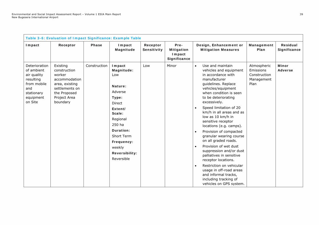
Environmental and Social Impact Assessment Report – Volume 1 ESIA Main Report New Bugesera International Airport
39
Table 3-6: Evaluation of Impact Significance: Example Table
Impact Receptor Phase Impact Magnitude
Receptor Sensitivity
Pre-Mitigation
Impact Significance
Design, Enhancement or Mitigation Measures
Management Plan
Residual Significance
Deterioration of ambient air quality resulting from mobile and stationary equipment on Site
Existing construction worker accommodation area, existing settlements on the Proposed Project Area boundary
Construction Impact Magnitude: Low Nature: Adverse Type: Direct Extent/ Scale: Regional 250 ha Duration: Short Term Frequency: weekly Reversibility: Reversible
Low Minor Use and maintain vehicles and equipment in accordance with manufacturer guidelines. Replace vehicles/equipment when condition is seen to be deteriorating excessively.
Speed limitation of 20 km/h in all areas and as low as 10 km/h in sensitive receptor locations (e.g. camps).
Provision of compacted granular wearing course on all graded roads.
Provision of wet dust suppression and/or dust palliatives in sensitive receptor locations.
Restriction on vehicular usage in off-road areas and informal tracks, including tracking of vehicles on GPS system.
Atmospheric Emissions Construction Management Plan
Minor Adverse

Environmental and Social Impact Assessment Report – Volume 1 ESIA Main Report New Bugesera International Airport
40
3.2.6 Impact Mitigation
As part of the ESIA process, when adverse impacts are identified (which cannot be managed via design controls/incorporated mitigation), mitigation measures are developed (including avoiding, management and monitoring actions). The process of identifying design controls and mitigation measures must follow the sequence of the mitigation hierarchy (Figure 3-3), as specified in IFC PS1, which is widely regarded as the best practice approach to managing impacts.
First, efforts are made to avoid or prevent, then minimise or reduce adverse impacts. Through the application of design controls. Subsequently, these design controls are supplemented by additional design controls plus mitigation measures to be applied through the effective management of project-related activities during construction, operation and decommissioning. Any remaining significant residual impacts are then addressed via consideration of mitigation measures such as offsetting and compensation.
Figure 3-3: Mitigation Hierarchy
Identifying, assessing and then selecting mitigation measures is a process involving the ESIA team, working with the project engineers/architects/contractors, to identify practicable and cost-effective approaches to mitigate the impacts. These measures are agreed and integrated into the Project ESMP.
3.2.7 Assigning Impact Significance: Unplanned Events
For unplanned events, it is necessary to add the likelihood of an event occurring to the methodology. Table 3.7 provides definitions for the likelihood categories that need to be applied to all events.

Environmental and Social Impact Assessment Report – Volume 1 ESIA Main Report New Bugesera International Airport
41
Table 3-7: Likelihood Categories for Unplanned Events
Likelihood Definition
Certain Events that will occur during normal operating conditions (i.e., they are inevitable).
Possible Events that are likely to occur at some time during normal operating conditions.
Unlikely Events that are unlikely but may occur at some time during normal operating conditions.
Improbable Events that are extremely unlikely to occur during normal operating conditions.
Unplanned events will often result in a major impact significance, even with mitigation/ remedial measures in place e.g. major oil spills. In such cases, not only must measures be in place to manage an unplanned event, but the probability must be minimised to levels seen to represent good industry practice. In this table, unplanned events with a High residual impact significance would need to be categorised as ‘Improbable’. In many cases, quantified risks assessment will be required to quantify the probability of an event and this should be compared with industry good practice. Where quantification is possible, the likelihood criteria should include quantified probabilities i.e. Improbable equates to less than a 1x10⁻⁶ event.
3.3 Cumulative Impacts
The IFC (2013) released a Guidance Note “Cumulative Impact Assessment and Management – Guidance for the Private Sector in Emerging Markets” in August 2013. The guidance note introduces a framework for identifying and assessing potentially significant cumulative impacts. The assessment of cumulative impacts has been undertaken in accordance with this Guidance Note.
3.3.1 Cumulative Impact Assessment (CIA)
IFC PS1 requires that the Proposed Project encompass “cumulative impacts that result from the incremental impact, on areas or resources used or directly impacted by the project, from other existing, planned, or reasonably defined developments at the time the risks and impact identification process is conducted.”
IFC PS1 offers some context to limit the cumulative impacts to be addressed to “those impacts generally recognised as important on the basis of scientific concerns and/or concerns from Affected Communities” and provides examples such as “incremental contribution of gaseous emissions to an airshed; reduction of water flows in a watershed due to multiple withdrawals; increases in sediment loads to a watershed; interference with migratory routes or wildlife movement; or more traffic congestion and accidents due to increases in vehicular traffic on community roadways.”
The IFC Performance Standards recommend that this assessment should (a) “be commensurate with the incremental contribution, source, extent, and severity of the cumulative impacts anticipated,” and (b) “determine if the project is incrementally responsible for adversely affecting an ecosystem component or specific characteristic beyond an acceptable predetermined threshold (carrying capacity) by the relevant government entity, in consultation with other relevant stakeholders”.

Environmental and Social Impact Assessment Report – Volume 1 ESIA Main Report New Bugesera International Airport
42
Cumulative impacts consider what impacts the Proposed Project will have on valued environmental and social components (VECs) in term of existing or future developments and how to avoid or minimise these impacts to the greater extent possible. This is defined in more detail below.
3.3.2 Cumulative Impact Assessment Methodology
A future development of approximately 1,500 ha may be established following the construction of the airport, which is referred to as the Aerotropolis. It is proposed to include a Special Economic Zone (SEZ) and an entertainment area. The SEZ may include areas that are zoned for commercial and light industry and the entertainment area may include hotels, general entertainment and a theme park. There are no approved plans or any established timeframes for the Aerotropolis so potential cumulative impacts with the Proposed Project have only been considered in outline terms in Chapter 19: Cumulative Impact Assessment.
3.4 Environmental and Social Management
Chapter 20: Environmental and Social Management has been prepared to describe how the Project Environmental and Social Management System (ESMS) will be implemented and summarise the content of overarching construction and operation phase Environmental and Social Management Plans (C-ESMP and O-ESMP respectively) and topic specific construction and operation phase ESMPs that are being developed by BAC and Mota-Engil, the Engineering, Procurement and Construction (EPC) Contractor.
The chapter explains how environmental and social commitments will be captured from the ESIA to ensure that the Proposed Project is constructed and operated in accordance with the relevant regulatory and legislative requirements, international guidance and Good International Industry Practice (GIIP).
The introductory sections of Chapter 20 describing the Project ESMS and summarising the contents of the ESMPs is followed by a summary of residual impacts with mitigation and monitoring measures.
3.5 Stakeholder Engagement
Stakeholder engagement has been a part of the ESIA process. Stakeholder engagement was, and continues to be, undertaken throughout the development of the Proposed Project to ensure that interested parties are aware and informed of the Proposed Project and have an opportunity to provide input regarding potential Proposed Project impacts and mitigation measures. To date, this stakeholder engagement has involved a wide range of stakeholders as detailed in Chapter 7: Stakeholder Engagement.
A Stakeholder Engagement Plan (SEP) (Technical Appendix 7.1) was prepared for the Proposed Project to identify stakeholders and their interests, describe the consultation and establish a framework for stakeholder engagement activities to be undertaken as the Proposed Project progresses beyond the ESIA phase and thus ensure the management of impacts takes stakeholder concerns into account.
As indicated previously, the Scoping Report was submitted to the lenders and to REMA. REMA further consulted with a number of national level stakeholders and government institutions as part of its review of the Scoping Report. The stakeholder engagement process has also helped the ESIA to scope potential impacts and concerns identified by the wider public, which is further outlined in Chapter 7: Stakeholder Engagement.

Environmental and Social Impact Assessment Report – Volume 1 ESIA Main Report New Bugesera International Airport
43
3.6 Assumptions and Limitations
The principal assumptions that have been made, and any limitations that have been identified in undertaking the ESIA are set out below. Assumptions specifically relevant to each technical topic have been set out in each technical chapter of the ESIA Report.
Baseline conditions have been established from a variety of sources, including historical data, but due to the dynamic nature of certain aspects of the environment, conditions at the site and surrounding land uses may change;
It is assumed that information received from third parties is accurate, complete and up to date;
The assessments contained within each of the technical chapters are based on the assumption that incorporated mitigation measures set out in application drawings, through regulatory regimes or via the management controls as set out in Chapter 6: Proposed Project Description are implemented; and
Where detailed information has not been available, reasonable assumptions have been made, and have been clearly set out, based on experience of developments of similar type and scale to enable assessment of likely significant effects.
During the detailed design, construction and operation phases of the Proposed Project, there may be a requirement to amend design elements or processes which would result in a deviation from that presented in Chapter 6: Proposed Project Description. The Proposed Project will have a management of change process to manage and track any such amendments, and to:
Assess their potential consequences with respect to environmental and social impacts; and
Inform and consult with relevant parties on the nature of the impact and on proposed mitigation measures (where a significant impact is likely to arise as a consequence of the amendment or change), where practical and appropriate.

Environmental and Social Impact Assessment Report – Volume 1 ESIA Main Report New Bugesera International Airport
44
4. ANALYSIS OF ALTERNATIVES
4.1 Introduction
The IFC Performance Standards on Social and Environmental Sustainability specify the requirements for the assessment of feasible alternative configurations for a project:
“For greenfield developments or large expansions with specifically identified physical elements, aspects, and facilities that are likely to generate potential significant environmental or social impacts, the client will conduct a comprehensive Environmental and Social Impact Assessment, including an examination of alternatives, where appropriate.”
“For greenfield developments, the ESIA includes an examination of technically and financially feasible alternatives to the source of such impacts, and documentation of the rationale for selecting the particular course of action proposed. The purpose of the alternatives analysis is to improve decisions on project design, construction, and operation based on feasible alternatives to the proposed project. This analysis may facilitate the consideration of environmental and social criteria at the early stages of development and decision-making based on the differences between real choices. The alternatives analysis should be conducted as early as possible in the process and examine feasible alternatives; alternative project locations, designs, or operational processes; or alternative ways of dealing with environmental and social impacts”
This section explores the main alternatives considered by BAC and previously, and gives an indication of the main reasons for the selection of the current location.
During the analysis of alternatives, the following topics were considered:
Alternative modes of transportation;
Possible alternative locations for a new airport; and
No action alternative.
Furthermore, in accordance with Rwandan Organic Law No. 04/2005 of 08/04/2008, possible alternatives should be identified and environmental attributes compared. Alternatives should cover both project location and process technologies. It must be noted that the impacts associated with the location and technical alternatives associated with the Proposed Project will not be quantified as the GOR has, as defined in the following sections, identified a location for the Proposed Project. Furthermore, BAC has contracted airport engineers (ACV) who has designed the NBIA to international standards.
4.2 The Need for a New Airport
The development of the Proposed Project was influenced by the decision that the existing KGL is unable to support the air travel needs of Rwanda in the near future due to rapid development within the country.
KGL is the main international airport in Rwanda and it is located in the suburb of Kanombe, at the eastern edge of Kigali. The passenger traffic at KGL is growing rapidly. In 2004, the airport served 135,189 passengers, in 2013 this increased to nearly 600,000 passengers, and then to 710,000 in 2016, with the airport designed to handle only 400,000 passengers per year.
KGL does not have space for the construction of additional runways or facilities. Therefore, proposals for a new airport were put forward to replace KGL to accommodate the additional passenger traffic. KGL will remain operational for military purposes.

Environmental and Social Impact Assessment Report – Volume 1 ESIA Main Report New Bugesera International Airport
45
The need for the Proposed Project is also influenced by Rwanda’s stable political systems, stable economic development, increased tourism volumes, high passenger growth rates driven by international traffic, not affected by seasonal demand and that Rwanda has available land for development, taking cognisance of international standards and best practice.
The Proposed Project will target additional regions in view of commencing direct long-haul flights to Western Africa, Southern Africa, Eastern Africa and Gulf destinations. This will result in the NBIA becoming a major hub for transit passengers, freight and cargo. The NBIA will also better position the country as a leisure and business destination as well as an information and communication technology and mining/manufacturing hub in central Eastern Africa.
Through the development of the NBIA, the home carrier, RwandAir, which currently has the capacity of 13 aircraft fleet housed at the KGL, will increase to a total fleet of 20 aircraft enabling non-stop long-haul services to the USA China, India and Europe. RwandAir will also expand codeshare partners to Kenya Airways, South African Airways, Turkish Airlines, China Southern, Oman Air and Etihad.
4.3 Alternative Modes of Transportation
There are no alternatives to the Proposed Project that will fulfil the functions of providing relatively fast, cheap transportation. Road, rail and water transport are not suitable substitutes for an airport. Rwanda is a landlocked country with no waterbody present that can be used as a mode of transport. Furthermore, there is a limited railway transport system in the country. Road transportation is the only possible means but this is an inefficient alternative over long distances. Alternatives for the Expressway are discussed in Section 4.6.
4.4 Alternative Locations
The Proposed Project location has been selected for its relatively flat topography in a country where there are many undulating hills and slopes.
There was one other site identified during the pre-feasibility stage for the Draft ESIA (2010); however, this was rejected for the following reasons:
The distance to and from Kigali was more than 70 km;
Less favourable topography on the site; and
Site was the smaller of the two sites.
The site for the Proposed Project was selected as the best location by a committee of technical representatives from the various ministries of the GOR in 2008, primarily based on the comparatively flat topography, suitable land area, distance to Kigali, relatively low density of inhabitants, distance from sensitive receptors and compliance with aviation requirements (including the requirement that all aircraft must remain in Rwandan airspace and avoid penetrating Burundi airspace).
4.5 No Action Alternative
Based on the increasing trend in air traffic passenger numbers arriving or transiting through KGL, the airport is currently operating beyond its limited capacity with insufficient space for expansion and therefore unable to cater for the increasing demand. Without the Proposed Project, the people of Rwanda would still need to be served by KGL. As this would limit Rwanda’s air-traffic potential, it was considered unfeasible to take no action to further increase airport capacity to accommodate this rising trend. Furthermore, with an increase of air traffic into the KGL, the potential of ICAO and IATA safety risks will increase resulting in anticipated incidents and accidents with the current airport

Environmental and Social Impact Assessment Report – Volume 1 ESIA Main Report New Bugesera International Airport
46
4.6 Alternative Designs
4.6.1 Details on alternative designs of the airport were not available. However, it is understood that the original design accounted for a larger airport area with more runways. This original design was discounted as it was deemed unfeasible financially.
4.6.2 Expressway Alternatives
Existing national roads servicing Rwanda, although bitumen surfaced, rarely comprise dual-lane carriageways that can accommodate the increasing traffic demand and load volumes from heavy-vehicles. National roads also lack lighting at populated areas such as villages which pose safety risks to the communities.
Currently, the Proposed Project can be accessed via the KK-15 Road and an unsurfaced road of approximately 9 km from Nyamata. This road will be used during construction activities until the Expressway has been completed. This route covers a distance of 46 km from the Airport Area. This will entail BAC to upgrade 37 km of the KK-15 Road as well as the unsurfaced road from Nyamata to the Airport Area. This is considered less feasible than developing the Expressway and will require greater distances to be travelled from the airport to Kigali.
The Expressway is a key transportation infrastructure that the Rwanda Ministry of Transportation intends to invest in the near future, linking the NBIA to the existing KK15 road, between Nyamata and Kigali.
The base data can be summarised as follows:
Start point, immediately south of the Nyabarongo bridge, over the Akagera River;
End point, precisely located at the southwest roundabout of the airport main square;
Base design speed of 80 km/h;
Typical cross section with one lane in each direction, plus shoulders, with a total width of 9 m; and
Level links, both at the start and end points and on intermediate links to existing, unpaved roads that cross the Expressway alignment.
The data available derives from general knowledge of the Proposed Project Area and a site visit to assess the basic environment characteristics; mostly flat or gently sloped terrain, used for agriculture, and a stretch of marshland that can be flooded and has to be crossed by the Expressway.
The selection of the road corridor was primarily based on the principles of value engineering and environmental mitigation, seeking to preserve, as much as possible, the local infrastructure, social context, fauna and flora, landscape, without the compromising the Expressway’s serviceability and functionality. The primary decision in selecting the Expressway route was to reduce earthworks volumes and balance excavation and fill volumes. Furthermore, the Expressway route alignment also considered the following:
The longitudinal section is considered to be moderately uniform;
Disruption to the existing KK-15 Road will be minimised by linking up to the Expressway at an existing roundabout, located east of the K-15 Road;
The Expressway elevation, along the wetlands, will be protected from the Akagera River maximum flood levels;
Expressway alignment was designed to minimise the number of wetlands/swamp/marshland crossings and reduce its length. The alignment was designed to cross the wetlands/swamp perpendicularly thereby achieving the narrowest crossing of

Environmental and Social Impact Assessment Report – Volume 1 ESIA Main Report New Bugesera International Airport
47
550 m. In order to minimise impacts on stream flow, a main box culvert and lateral pipes will be installed; and
No regional or district road will bisect the proposed Expressway route.
The Expressway route is, therefore, considered the most suitable alternative.

Environmental and Social Impact Assessment Report – Volume 1 ESIA Main Report New Bugesera International Airport
48
5. DEVELOPMENT CONTEXT
5.1 Area Overview
The Proposed Project is to be situated within Rilima and Juru sectors of the Bugesera District in the Eastern Province of Rwanda (Figures 1-1 and 1-2). The Proposed Project Area is approximately 23 km southeast of Kigali City, generally following the direction of the Kicukiro-Nyamata-Nemba highway (KK-15 Road), which connects Rwanda to Burundi.
The Airport Area covers an area of approximately 2,500 ha, which was previously largely used for subsistence farming.
5.2 Site Description
The Airport Area is located within an area dominated by an agrarian landscape with a prevalence of shrub crop production arranged in small to medium scale fields with occasional scrubby trees. There are a number of minor unsurfaced local roads that cross the Airport Area. Inhabitants and landowners within the Airport Area were resettled from 2010 onwards and have been compensated and/or resettled offsite. This area is owned by the GOR and is currently leased by BAC.
The land use along the Water Pipeline servitude largely comprises subsistence farming. No rural homesteads will be impacted by the pipeline route. The route of the Expressway crosses subsistence farming land uses, rural homesteads, floodplains and dissects the Nyabarongo Wetland.

Environmental and Social Impact Assessment Report New Bugesera International Airport
49
Figure 5-1: Airport Area Photos
5.3 Environmental Setting
This section of the ESIA Report provides a summary of the environmental context related to the Proposed Project and describes the current status and value of the environmental setting. The characterisation is essential for the assessment of the Proposed Project’s potential impacts and the subsequent development of appropriate mitigation measures. More detailed baseline information is provided within each technical chapter.
5.3.1 Climate
Compared to other regions of the country, Bugesera is characterised by a very hot climate resulting from the absence of mountains, the relatively low altitude, low rainfall and excessively prolonged periods of drought. The district has a tropical climate with mean temperatures ranging from 15-16 degrees Celsius at night to 26-28 degree Celsius around noon. Humidity levels vary from 40-55% during the dry season months and 60-90% during the wet season months.
A total of 900-1200 mm of rain falls over Bugesera each year. The region experiences two distinct tropical wet seasons (mid-March to mid-June and mid-October to December), separated by one short (January to mid-March) and one long dry season (mid-June to mid-October). Most precipitation is generated from short-lived convective weather events such as that from tropical thunderstorms and squall lines.

Environmental and Social Impact Assessment Report New Bugesera International Airport
50
5.3.2 Air Quality
Rwanda has one of the world’s lowest per capita emissions of greenhouse gases (GHGs). It is highly vulnerable to the impacts of temperature and rainfall changes due to climate change since it relies on rain-fed agriculture for subsistence livelihoods.
Transportation is one of the largest sources of air pollution, especially in Kigali City and air pollution is a growing concern in Rwanda’s urban areas. However, air quality over the Proposed Project Area is considered to be good.
5.3.3 Topography
The Airport Area is situated on a plateau that rises from approximately 1,400 m in the south, north and east to a maximum elevation of 1,437.5 m at the centre. The lower areas fall rapidly to the river valleys at slopes ranging from 2.5% in the northern quadrant to 12.5% in the eastern quadrant of the site.
The Airport Area is situated on a relatively flat, slightly undulating mesa that is surrounded by poorly drained, swampy rivers to the north and west while there a number of small lakes to the east.
The Expressway route hugs the swampy areas of the Nyabarongo Wetland, as such the profile along the route is relatively flat.
5.3.4 Geology and Soils
The morphology and topography at the Proposed Project Area indicates an altered granite massif. The depth of soil cover (8 to 34 m) and the occurrence of laterite in the vicinity are both indicative of a deep weathering profile. The solid geology underlying the weathered granite in the Airport Area consists of Precambrian granitic rock, metaquartzites, pegmatites and mica schists. The silty/clayey soils overlying the granite are due to weathering of the granite.
5.3.5 Water Resources
The main natural water bodies within the influence of the Proposed Project are:
Mwesa and Kibilizi seasonal streams, located partially onsite, as well as an unnamed tributary discharging to Lake Kidogo
Lake Kidogo, located approximately 2 km southeast of the Airport Area;
Lake Gashanga, located approximately 4.8 km east of the Airport Area;
Lake Rumira, located approximately 5 km southeast south of the Airport Area;
The Nyabarongo River, which will be crossed by the Expressway approximately 9.5 km northwest of the Airport Area. The Nyabarongo River is also located approximately 7 km southeast of the Airport Area, beyond the lakes listed above (this is its closest location to the Airport Area); and
The Nyabarongo Wetland Area, partially crossed by the northern end of the Expressway corridor.
The Proposed Project also falls within the Nyabarongo Wetland area, specifically along the Expressway.

Environmental and Social Impact Assessment Report New Bugesera International Airport
51
5.3.6 Biodiversity
The Proposed Project Area is located outside national protected areas. The nearest protected area is Akagera National Park located approximately 40 km away (northeast). The Proposed Project Area includes parts of the Nyabarongo Wetland Important Bird Area (IBA), which is an internationally recognised area as defined by IFC PS6.
The Proposed Project Area is characterised by five vegetation types: anthropic landscapes, grassland, wooded grassland, bushland and thicket and swamp and aquatic vegetation. A total of 103 plant species were recorded in the different vegetation types. Birds, mammals, amphibians and reptiles have been identified within and in the vicinity of the Proposed Project Area.
5.4 Socio-Economic Setting
This section of the ESIA Report provides a summary of the high level social and economic baseline relevant to the Proposed Project (i.e. within Bugesera District):
According to the 2012 census, Bugesera District has a population of 361,914 people with an average annual growth rate of 3.1%;
The District is relatively poor compared to other districts and the nation as a whole with about half of the population being poor, including 20% that is extremely poor;
Approximately 30% of households still use an unimproved drinking water source;
Less than 10% use electricity for lighting;
Almost 70% of the households walk more than an hour to reach a health centre;
Agriculture (crop farming and livestock) is the main economic activity and source of income, but most households (approximately 70%) cultivate under 0.9 ha of land (which is the Food and Agriculture Organization’s suggested land amount for Rwandan households to conduct sustainable agriculture), including 30% with under 0.3 ha of land;
There is relatively high-out migration rate indicating a lack of acceptable economic opportunities; and
Employment status by sex indicates that females are more occupied in small-scale farm activities than males and less involved in other types of employment that provide high income such as independent non-farm or wage non-farm work.
There are no declared archaeological, paleontological and/or historic monuments sites in Bugesera District.
5.5 Definition of the Proposed Project Area of Influence and Sub-Areas of Influence
The minimum study area for conducting an ESIA for a project is defined as the Area of Influence (AOI) of the project. The AOI is generally larger than the Proposed Project Area in order to address potential impacts. In this context, the AOI is the geographic area that may experience impacts to the biological, physical or socio-economic environments from resettlement, earthworks, construction and operation of the Project components. The Proposed Project AOI includes the receptors that may be permanently and temporarily affected by the Proposed Project features.

Environmental and Social Impact Assessment Report New Bugesera International Airport
52
For the ESIA, the AOI has been defined based on relevant requirements in IFC PS1 Assessment and Management of Environmental and Social Risks and Impacts, considering: “the area likely to be affected by: (i) the project and the client’s activities and facilities that are directly owned, operated or managed (including by contractors) and that are a component of the project; (ii) impacts from unplanned but predictable developments caused by the project that may occur later or at a different location; or (iii) indirect project impacts on biodiversity or on ecosystem services upon which Affected Communities’ livelihoods are dependent”.
Table 5-1 summarises the Proposed Project AOI and sub-AOIs for different environmental and social topics. For all these topics, different spatial extents (study areas/sub-AOIs) have been defined and studied in terms of baseline data collection and impact assessment.

Environmental and Social Impact Assessment Report – Volume 1 ESIA Main Report New Bugesera International Airport
53
Table 5-1: Sub-Areas of Influence
Topic Issue Boundary Receptor Comment
Environmental and social impacts within the Proposed Project Area
Design, build and operate within Proposed Project Area
Proposed Project Area that contains all structures and infrastructure associated with the Airport Area, Construction Camp, Expressway, upgraded quarry road and temporary Water Pipeline
Natural resources and human settlements and facilities
Air Quality Air quality during construction and operation
Please refer to Chapter 9: Air Quality Population within the vicinity of the airport
Noise Noise during construction and operation
Please refer to Chapter 10: Noise and Vibration
Residents, construction and operation phase workers and potentially wildlife
Water Resources Water quality and supply during construction and operation Flood risk
Surface water bodies or hydrological receptors either within the Proposed Project Area or a direct hydrological receptor within a water catchment shared with the Proposed Project Area;
Surface water bodies adjacent to the Expressway; and
Water resources to be utilised as water supply for the Proposed Project.
Surface water bodies, groundwater and downstream receptors
Transport/Roads, including Expressway
Increased road traffic Length of the Expressway from the Airport Area to the junction with the existing KK-15 National Road and quarry road
Local community, road users (highway and secondary roads)
Construction Materials Sourcing
Requirement for quantities of construction aggregate
Locations of the material borrow areas and of the quarry
Quarries, regional economy, transport mechanism
Locations of the material borrow areas and quarry to provide fill and construction material to the Proposed Project have been confirmed and were assessed.

Environmental and Social Impact Assessment Report – Volume 1 ESIA Main Report New Bugesera International Airport
54
Table 5-1: Sub-Areas of Influence
Internationally Recognised Areas, Protected areas
Impacts to qualifying features 15 km of Proposed Project Area Qualifying features
Ornithology Loss of habitat, disturbance, etc. 15 km of Proposed Project Area Birds and their habitats
Aquatic Ecology Possible negative impacts of temporary Water Pipeline and Expressway, including environmental emissions (such as sedimentation, noise and dust) on aquatic environment
15 km of Proposed Project Area Aquatic species and habitats
Terrestrial Flora and Fauna
Loss of habitat and species of conservation concern, disturbance, fragmentation, etc. Disturbance to species and habitats.
15 km of Proposed Project Area Flora and fauna species and habitats
Waste Creation and management of wastes Proposed Project Area for onsite waste handling and storage as well as Bugesera District and any other areas where waste arisings from the Proposed Project are proposed to be transported for processing
Increased volumes of waste requiring handling and transport
Soil and Geology Potential soil disturbance and contamination
The lands permanently and temporarily affected by the Proposed Project features (i.e. the Proposed Project Area).
Soils
Archaeology and Cultural Heritage
Potential destruction of archaeology and cultural heritage through construction works and operation phase
Proposed Project Area Archaeology cultural heritage artefacts and unknown burial sites
Socio-Economic Potential socio-economic impacts during construction and operation
Please refer to Chapter 18: Socio-Economic Local community
Landscape and Visual
Landscape and visual impacts during the construction and operation phase
Please refer to Chapter 15: Landscape and Visual.
Landscape and visual receptors

Environmental and Social Impact Assessment Report – Volume 1 ESIA Main Report New Bugesera International Airport
55
6. PROPOSED PROJECT DESCRIPTION
6.1 Introduction
This chapter provides a description of the physical characteristics and operational elements of the Proposed Project, including earthworks, construction and operational arrangements. This chapter considers the following principal elements of the Proposed Project:
Design and technical specifications;
Earthworks and construction management;
Onsite and offsite infrastructure;
Site layout and built form; and
Operational considerations.
The content of this chapter is based primarily on the following documentation developed by Airport Design Management: Airport Consulting Vienna (ACV) and by Mota-Engil:
Master Plan Bugesera Greenfield Airport Final Report (Version 4.0) dated February 2017;
NBIA Master Plan (Version 06-00) dated May 2017;
NBIA Preliminary Design Airside Report (Version 01-00) dated May 2017;
NBIA Conceptual Design Report Part A and Part B (Version 01-00) dated March 2017; and
NBIA Campsite – Descriptive Memory dated March 2017.
The airport configuration has been driven by market demand and international standards (International Civil Aviation Organisation (ICAO), International Air Transport Association (IATA) and the Federal Aviation Authority (FAA)). The vision for the technical development is focused on a single roof concept, space optimisation, extension options, functionality and efficient operations, above average commercial space and optimised capital expenditure.
The airside configuration will initially consist of a single runway with space for an additional runway in the future. One parallel taxiway will be constructed in order to improve the runway capacity and airside operations.
In summary, the Proposed Project will include, the following key elements:
A Runway (3,750 m in length by 45 m in width) and one parallel taxiway in order to improve runway capacity and the airside operations;
A Passenger Terminal (29,900 m2) will comprise check-in counters, security check points, gates, passenger boarding bridges, immigration and emigration counters, and retail and commercial areas;
Additional facilities will include:
General Aviation Terminal;
Presidential Terminal;
Cargo area;
Air Traffic Control (ATC) tower;
Aircraft Rescue and Firefighting (ARFF) building;
Ground Service Equipment (GSE) maintenance building;
Catering area;
Police and anti-terror building;
Aircraft maintenance hangar;
Administrative area;

Environmental and Social Impact Assessment Report – Volume 1 ESIA Main Report New Bugesera International Airport
56
Access security;
Power distribution;
Waste management area;
Wastewater treatment facility;
Fuel farm; and
Car parking.
A Water Pipeline of approximately 5 km will be installed from Lake Kidogo to a water treatment plant within the Airport Area to provide water for the construction phase; and
A 14.5 km Expressway to link the airport to the national KK-15 Road joining at the existing Nyabarongo Bridge.
Associated Facilities will include the infrastructure for the permanent supply of power and water during the operation phase of the Proposed Project.
6.2 Proposed Project Phasing
The Proposed Project will be delivered in five phases. The first phase is planned to be completed by 2020 and the final phase by 2045. Table 6-1 summarises the five phases associated with the Proposed Project and relevant key information for each phase.
Technical Appendix 6.1 includes illustrations of the Proposed Project facilities described above, which are to be developed within the Airport Area. These illustrations include representations per phase of the Proposed Project.
Table 6-1: Master Plan Development Phases46
Phase Phase 1 Phase 2 Phase 3 Phase 4 Phase 5
Completion Year
2020 2030 2035 2040 2045
Million Annual Passengers
1,77 2,52 3,42 4,48 5,72
Design Peak Hour (Passengers)
856 1,157 1,490 1,859 2,253
Annual Cargo (Tons per Annum)
13,803 19,542 27,626 39,434 56,416
Projects per Phase
Runway Taxiway Apron
Passenger Terminal
Presidential Terminal Airport
Facilities Cargo Area
Aircraft Maintenance
Apron Passenger Terminal Airport
Facilities Parking Areas
Apron Airport
Facilities Cargo Area Extension Office Area
Hotel Aircraft
Maintenance Parking Area
Taxiway Apron
Passenger Terminal Airport
Facilities Landside Roads
Parking Area
Taxiway Apron
Passenger Terminal Airport
Facilities Cargo Area
Parking Area
46 Note: Any items repeated in phases 2-5 are extensions to the facilities constructed in the previous phase

Environmental and Social Impact Assessment Report – Volume 1 ESIA Main Report New Bugesera International Airport
57
Table 6-1: Master Plan Development Phases46
Landside Roads
Commercial Area
Parking Area
6.3 Description of Proposed Project Facilities, Components and Activities
Information on the various airport elements and Associated Facilities is included below. This is followed by sections on the airport development phasing and construction and operation activities.
6.3.1 Proposed Project Facilities
Technical Appendix 6.1 presents the layout of the Proposed Project facilities described below, which will be developed within the Airport Area during the five phases of the Proposed Project
6.3.1.1 Runway
The runway alignment has been determined based on the consideration of prevailing wind conditions, regional airspace, local obstacles and site geometry. The International Civil Aviation Authority (ICAA) and FAA recommend that the airport runway layout be orientated so that the usability factor of the airport is not less than 95%. Taking into consideration the wind direction (southeast) and to minimise earthworks (cut and fill), the runway was designed to run in a northwest/southeast direction to comply with ICAO and FAA standards.
Runway operational modes and assignments have been assessed based on airspace and runway capacity requirements and route mix. This informs the overall operational concept, Passenger Terminal location and airline assignment assumptions. Taxiway layouts have been developed to support proposed runway operational modes and optimise airfield efficiency, minimising taxi times and delays.
The runway will be 3,750 m long and 45 m wide. At both ends of the runway, a stopway of 60 m x 45 m will be installed. The runway shoulders will be 7.5 m wide and a Runway End Safety Area (RESA) of 180 m length and 160 m width will be provided at both ends of the runway.
6.3.1.2 Passenger Terminal
The Passenger Terminal will be the main terminal for the airport and will comprise 22 check-in counters, six security check points, 10 gates, six passenger boarding bridges, 10 immigration counters for arrival and 10 emigration counters for departure. Approximately 4,700 m2 of the terminal will be reserved for retail and commercial activities (shops, lounges, offices, etc.). The terminal will be 29,900 m2 in Phase 1 and 39,400 m2 by Phase 5. Figure 6-1 provides a schematic representation (cross section) of the building. The building will have a maximum height of 20.5 m AOD.
Figure 6-1: Cross Section of the Passenger Terminal

Environmental and Social Impact Assessment Report – Volume 1 ESIA Main Report New Bugesera International Airport
58
6.3.1.3 General Aviation Terminal
The General Aviation (GA) Terminal will be a one level building with elevated sections for administrative offices and technical rooms in the centre. It will have a maximum height of 7.48 m AOD and will be located west of the GSE maintenance building and Passenger Terminal. The GA terminal will initially be 1,200 m2 in Phase 1. Figure 6-2 provides a schematic representation (cross section) of the building.
Figure 6-2: Cross Section of the General Aviation Terminal
6.3.1.4 Presidential Terminal
The Presidential Terminal design is based on following aspects:
The Presidential Terminal will be in a separate location to the Passenger Terminal and GA Terminal northwest of the runway;
To assure a high level of security a separate access and additional security checkpoints are foreseen as well as constructing walls that are resistant to firearm attacks;
The design layout foresees a two-story building of 9.38 m AOD at maximum height, as well as a basement level;
Governmental requirements (i.e. security measures) have been incorporated in the conceptual design; and
The building will provide a diplomatic reception area, conference and lounge areas for very important persons (VIPs), a press conference area and security and catering facilities.
The Presidential Terminal will be 3,000 m2 in Phase 1. Figure 6-3 provides a schematic representation (cross section) of the building.
Figure 6-3: Cross Section of the Presidential Terminal Building
6.3.1.5 Airport Support Facility Requirements
Support areas will be required to accommodate a wide range of facilities, many of which are likely to be planned and delivered by third parties (such as aircraft maintenance, rescue and firefighting services, cargo, and catering facilities). The Master Plan for the support areas provides a framework for the structured development of these areas, coordinated with the wider airport development plan. This will be refined over the concession period to suit the demands from third party operators.

Environmental and Social Impact Assessment Report – Volume 1 ESIA Main Report New Bugesera International Airport
59
6.3.1.6 Cargo
The cargo facility will include the following main areas:
Cargo Terminal, including customs, import and export, manipulation areas, storage for refrigerated goods, hazardous materials, animals, etc.; and
Landside parking (trucks and employees).
The Cargo Terminal building will have a maximum height of 9.35 m AOD and will be located east of the ATC tower and ARFF building.
6.3.1.7 Air Traffic Control (ATC) Tower
The facilities for the ATC tower have been designed according to international regulations. These will comprise the tower itself, work stations for the controllers and the radar, electrical equipment room, uninterrupted power supply (UPS) room, break rooms and kitchen. The ATC tower will be located between the police and anti-terror buildings and the ARFF building to the east of the Passenger Terminal.
6.3.1.8 Rescue and Firefighting Services
The Rescue and Firefighting Services (RFFS) facilities will include:
A Fire Station (the ARFF building), including offices, garages and other complementary functional areas;
A service bay for parking and maintenance of rescue and firefighting vehicles;
A RFFS training area; and
An additional water supply in case of emergency.
The building allocated for the firefighting services will be located east of the Passenger Terminal between the ATC tower and Cargo Terminal. It will have a maximum height of 11.27 m AOD. The edifice will accommodate the firefighting offices and facilities, and the service vehicles. A side service bay is also foreseen, for vehicle parking and maintenance.
6.3.1.9 Ground Service Equipment
The GSE services will include the following related activities:
Passenger services;
Load control;
Ramp handling; and
Aircraft servicing.
The GSE maintenance building will be located in the service area to the west of the Passenger Terminal. It will provide space for servicing and repair of all vehicles and equipment used for the servicing of aircraft. These consist of a number of special vehicles that are not roadworthy, i.e. that are not allowed to use public roads and can therefore not be serviced outside the Airport Area unless trucked to and from the garage.
The main components of vehicle and GSE maintenance will be:
Vehicle and GSE parking and staging areas, both open and covered (shelters);
Vehicle and GSE maintenance workshops, complete with special bays for equipment cleaning and painting;
Large storage facility for spare parts and consumables (mainly oil, hydraulic fluid and grease); and
Vehicle fuel station.
Environmental and Social Impact Assessment Report – Volume 1 ESIA Main Report New Bugesera International Airport
60
6.3.1.10 Flight Catering
The catering facilities will consist of a facility where meals are prepared for inflight use. The facility will be able to handle up to 1,000,000 meals per year. The building will be located in the service area to the east of the Passenger Terminal and include the following areas:
Kitchen;
Refrigeration areas;
Storage areas; and
Wash areas.
A one and a half level concept is foreseen with a maximum height of 7.48 m AOD. An employee canteen may be integrated in the ground floor of the building to serve all airport staff. The upper floor will also house changing rooms and administrative offices, and it has additional space for further storage rooms.
6.3.1.11 Police and Anti-Terror Buildings
The police and anti-terror buildings will be located in the service area to the east of the Passenger Terminal between catering facility and the ATC tower.
The police building facility will consist of a two-level building of 7.48 m AOD in height, which will include the following main areas:
Police station;
Police administration areas (including lockers and staff rooms);
Detention cells;
Dog kennels; and
Medical station.
The anti-terror building facility will consist of a one level building of 3.74 m AOD in height, which will include the following main areas:
Emergency operation centre;
Closed-Circuit Television (CCTV) control room; and
Accommodation for an Anti-Terror Unit.
6.3.1.12 Maintenance Repair and Overhaul
A Maintenance Repair and Overhaul (MRO) facility will be constructed to service aircraft to the east of the Airport Footprint. At Phase 1 it will include:
A hangar that can accommodate one Code E aircraft (heavy transport aircraft, such as a Boeing 747);
Additional offices;
Additional storages for flammables and explosives;
Apron area that can accommodate one Code E aircraft; and
An engine run-up stand.
6.3.1.13 Office Park
An office park will be located to the south of the Passenger Terminal. It will comprise the Airport Administration building, additional office buildings, a hotel and a water retention pond. At Phase 1, only the Airport Administration building, consisting of a high rise six-floor office building (26.52 m AOD), and the water retention pond will be constructed.

Environmental and Social Impact Assessment Report – Volume 1 ESIA Main Report New Bugesera International Airport
61
6.3.1.14 Fuel Farm
The Fuel Farm will be located at the western part of the airport and will include the following main areas:
Landside access;
Truck manoeuvring area;
Above ground storage tank(s) containing jet fuel and surrounding security area;
Technical facilities (e.g. pump stations, etc.);
Airside manoeuvring area; and
Airside fuelling station.
No underground storage tanks will be installed. Only jet fuel will be stored in the aboveground storage tanks. It is estimated that four 2,200 m3 tanks will be installed in various phases during the Proposed Project, which is summarised below.
Two 2,200 m3 tanks to be installed by 2020;
One 2,200 m3 tank to be installed by 2030; and
One 2,200 m3 tank to be installed by 2040.
6.3.1.15 Fuel System
The apron has been designed with a hydrant fuelling system. The general concept is shown in Figures 6-4 and 6-5. The dispensing method will use a hydrant at the end of the transfer fuel line.
The transfer fuel line will terminate within a control valve vault, containing the piping system control valves, electrical power and fuelling system controls. The electrical controls will consist of motor-operated control valves and fuel system control monitoring functions. From the control valve vault, the hydrant fuel line will be routed to the aircraft apron. The underground fuel piping system will have a cathodic protection system to prevent corrosion of steel pipes.
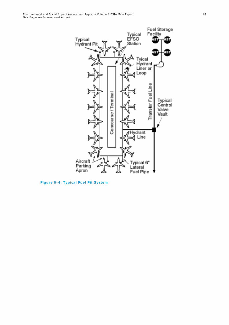
Environmental and Social Impact Assessment Report – Volume 1 ESIA Main Report New Bugesera International Airport
62
Figure 6-4: Typical Fuel Pit System

Environmental and Social Impact Assessment Report – Volume 1 ESIA Main Report New Bugesera International Airport
63
Figure 6-5: Fuel Pit Main Apron

Environmental and Social Impact Assessment Report – Volume 1 ESIA Main Report New Bugesera International Airport
64
6.3.2 Infrastructure and Utilities
6.3.2.1 Expressway
Construction on the new Expressway of approximately 14.5 km will commence in February 2018. This will connect the airport to the national KK-15 Road joining at the existing Nyabarongo Bridge, which crosses the Akagera River. The road will be paved (bitumen) and is anticipated to initially comprise a 9 m wide paved road (one lane in each direction 3 m in width with paved shoulders of 1.5 m on each side). This will be upgraded to cater for two lanes of traffic in both directions in the future in accordance with the future traffic demand that will be established at a later stage. The overall road reserve will be extended to 44 m in width. This reserve will be cleared of vegetation and not be hard surfaced. Services such as transmission lines (aboveground), water pipeline (to be confirmed), fibre, etc. will be installed within the unsurfaced road reserve. A cross-section is shown in Figure 6-6.
Figure 6-6: Expressway Cross-Section
A proposed route alignment is shown in Figure 6-7. The Expressway will be constructed in an area that is currently sparsely populated. The route cross areas of subsistence farming, rural homesteads and floodplains, and it dissects a wetland.
The Expressway will be designed and developed taking cognisance of safety aspects, such as traffic lights, stop signs, speed humps, traffic calming zones, street lights, etc. The Expressway will also incorporate drainage and stormwater control systems.
There are future plans to upgrade the existing surfaced KK-15 Road to Kigali, over a length of approximately 14.5 km. The existing road may be widened to accommodate increased traffic in the area.

Environmental and Social Impact Assessment Report – Volume 1 ESIA Main Report New Bugesera International Airport
65
Figure 6-7: Expressway Route (Source: BAC, 2017)

Environmental and Social Impact Assessment Report – Volume 1 ESIA Main Report New Bugesera International Airport
66
6.3.2.2 Security Fencing
The perimeter protection will comprise internal and external double fencing, with a patrol road and security lighting between the two fences. A video surveillance system will be installed within the Airport Area.
The external (landside) fence, demarcating public and private areas of land, will be 1.8 m high, with a three-strand razor wire anti-climb topping giving an overall height of 2.1 m above ground. The internal (airside) fence, demarcating airside and landside areas will be 2.4 m high, with a four-strand razor wire anti-climb topping giving an overall height of 2.9 m above ground. The fence will comprise 2.4 m high welded mesh panels fixed to steel posts, inclusive of additional security measures preventing burrowing. Figure 6-8 provides a schematic illustration of the proposed fencing at Phase 1.
Figure 6-8: Proposed Fencing
6.3.2.3 Drainage
The drainage system will comprise a network of seven drainage trenches covering the entire Airport Footprint. Surface water from the apron areas will be treated through oil separators. The discharge will then pass through two spillways and join the drainage channel located in the valley to the southwest of the Airport Area. Both spillways will pass the Expressway via rectangular culverts. There will also be two retention basins designed to manage the stormwater runoff and prevent erosion of the surrounding areas. Retention basin 1 will be situated at the northwest side of the airfield near the Presidential Terminal. The basin will cover an area of 38,000 m2. Retention basin 2 will be located at the southeast side of the airfield near the Aircraft Maintenance Area and will cover an area of 6,500 m2.
6.3.2.4 Wastewater and Waste Management
A permanent wastewater treatment facility will be constructed on the site as part of the construction phase and be located to the west of the passenger parking area and gas station.
A central waste collection and management area (located south of the ATC Tower and ARFF building) will be used for gathering, handling, sorting and storing of all solid waste generated on the airport.
Waste generated during the operation phase will likely include the following hazardous and non-hazardous (including recyclable) waste streams:
Inert wastes (concrete and masonry);
Scrap metal (ferrous and non-ferrous);

Environmental and Social Impact Assessment Report – Volume 1 ESIA Main Report New Bugesera International Airport
67
Putrescible waste;
Cooking oils;
Wooden pallets;
Tyres;
Plastics;
Paper and cardboard;
Domestic waste from administrative duties;
Glass;
Waste electrical equipment;
Waste oils;
Oil contaminated filters and rags;
Batteries;
Medical waste;
Contaminated soils; and
Chemical containers.
Further detail on waste generation and management is provided in Chapter 16: Waste Management.
6.3.2.5 Permanent Electricity and Water Supply
The Rwanda Water and Sanitation Corporation (WASAC) and Rwanda Energy Group (REG) will be responsible for supplying water and power respectively.
An estimated average of 675 m3 and a maximum of 1,000 m3 of water per day will be required during operation of the Proposed Development. The maximum hourly rate is estimated at 200 m3/h. A back-up underground supply reservoir of 1,000 m3 is foreseen within the Airport Area. There are also plans to install a rainwater capture for re-use at the airport.
The amount of electricity to be consumed during operation is estimated at 4 MW for Phase 1, rising up to 8 MW for Phase 5. The main airport substation, that will provide power supply to the airport, will be located directly east of the GA Terminal. It will accommodate the emergency generators, high voltage equipment, regulators, transformers and a control room. A dedicated fuel tank for supply to the emergency generators will also be accommodated within the facility.
The rest of infrastructure required for the permanent supply of electricity and water are considered as Associated Facilities and are described further in Section 6.3.3.
6.3.2.6 Lighting
The airfield ground lighting for the runway, taxiway and apron and the airfield lighting control system have been designed following ICAO requirements. The airfield ground lighting for the runway considers the following systems with LED technology:
Inset threshold lights/elevated wing bars light (high intensity);
Inset runway end lights (high intensity);
Inset runway centreline lights (high intensity);
Elevated runway edge lights (high intensity);
Elevated stopway lights;
Inset touch down zone lights (high intensity);
Rapid exit taxiway indicator lights (RETIL Lights);

Environmental and Social Impact Assessment Report – Volume 1 ESIA Main Report New Bugesera International Airport
68
Precision Approach Path Indicator (PAPI); and
Approach Lighting System (high intensity).
The lighting for the taxiways will include centreline lights, stop bar lights, runway guard lights and retroreflective markers. The lighting for the apron will comprise edge markers and floodlighting.
6.3.2.7 Bird Control System
As per the Aerodromes Certification Manual, the operator will prepare an Aerodrome Manual as part of the documents for the Airport Certification. This will also include a Wildlife Hazard Management Plan. This document will describe the procedures to manage wildlife hazards (such as bird strikes), including arrangements for assessing wildlife hazards, arrangements for implementing wildlife control programmes and persons responsible for dealing with wildlife hazards.
Several measures exist against to manage wildlife hazards, such as audio signal devices that beep to scare birds, removing empty nests in trees, implementing wildlife management measures to control and oversee the local habitat at the airport, netting or draining of streams, grass management, removing waste disposal sites, limiting other attraction to birds or bird monitoring systems. KGL for example, installed a bird collision avoidance system (BCAS), which detects, recognises, deflects and monitors birds. The system deflects birds with a loud audio signal and gathers data for statistical purposes. The measures that will be adopted at NBIA will be confirmed at a later stage.
6.3.2.8 Obstacle Limitation Surfaces
In accordance with ICAO requirements, BAC will implement a zone entitled ‘obstacle limitation surfaces’ (OLS), with the aim of defining airspace around the Proposed Project to be maintained free of obstacles to permit safe airport operations. This zone will extend approximately 8 km in all directions from the runway. There will be controls on siting and heights of structures within this zone.
6.3.3 Associated Facilities
As per the IFC PS1, Associated Facilities are facilities that are not funded as part of the project and that would not have been constructed or expanded if the project did not exist and without which the project would not be viable.
As stated in Section 6.3.2.5, the Rwanda Water and Sanitation Corporation (WASAC) and Rwanda Energy Group (REG) will be responsible for supplying water and power respectively for the operation phase. Limited information is currently available with regard to the design (in particular route alignment) or the date of these services. However, WASAC and REG will be obligated to provide water and power at least six months before the Proposed Project begins operation.
The existing water supply infrastructure in the region comprises three reinforced concrete ground reservoirs: Bugesera Reservoir (with 5,000 m3 storage capacity), Gahanga Reservoir (with 7,500 m3 storage capacity) and Kagarama Reservoir (with 7,500 m3 storage capacity). The Bugesera Reservoir is connected to the Bugesera Area Water Distribution Network, while the other two are connected to the Kigali Water Distribution Network.
A new water treatment plant is planned in the vicinity of the Proposed Project Area that will supply water to NBIA. It is understood that the water treatment plant will treat water coming from the Kanzenze Well Fields and then distribute the water to the three reservoirs mentioned above. A connection point from the Airport Area to the Kigali Water Distribution Network is

Environmental and Social Impact Assessment Report – Volume 1 ESIA Main Report New Bugesera International Airport
69
foreseen. Further details of the exact location and capacity of the water treatment plant and the pipeline route to the Airport Area are not currently available. The permanent water pipeline from the Kigali Water Distribution Network to the Airport Area will be an Associated Facility to the Proposed Project as per the IFC PS1 definition.
The source of electricity has yet to be confirmed. However, the power will likely be provided from two sources; the new Mamba peat power plant (80 MW installed capacity which is expected to be commissioned in 2019) located in Gisagara District in the Southern Province and the Rusumo hydroelectric project (80 MW installed capacity) on the border between Rwanda, Tanzania and Burundi.
There will be two 220 kV overhead transmission lines (OHTL) coming from each of these two power plants. According to the Rusumo OHTL RAP Summary47 (a summary for all RAPs prepared for Rusumo transmission components) there will be an OHTL from Rusumo to Kigali with an extension from the Rusumo OHTL to the Kigali OHTL at Shango sub-station leading to the airport. Both the Mamba and Rusumo OHTLs will terminate at the Majanja sub-station in the Juru Sector in the Bugesera District. From this substation, the voltage will be stepped down to 30 kV and a line (possibly underground) will terminate at the main airport substation.
The part of the Rusumo OHTL from Shango sub-station to the airport sub-station passing via Majanja sub-station will be an Associated Facility to the Proposed Project as per IFC PS1 definition. However, at this stage, it is unclear whether the Mamba peat power plant and the full length of the Mamba OHTL are also Associated Facilities. This is because it is unclear whether these will only supply the airport or whether they will supply other facilities as well.
The identified Associated Facilities will likely result in environmental and social impacts, in particular, they will likely require land acquisition. As mentioned above, WASAC and REG have responsibility for the supplying water and power and, thus, they also have responsibility for assessing and managing any environmental and social impacts in line with relevant legislative and regulatory standards.
Consistent with its commitment to adhere to the requirements set out in IFC PSs, BAC will engage with WASAC and REG to:
Confirm whether the Mamba peat power plant and the full length or only part of the Mamba OHTL are considered as Associated Facilities as per IFC PS1 definition;
Review EIA/ESIAs prepared for each of the Associated Facilities to identify project risks and potential significant impacts; and
Harmonise impact mitigation measures between the Proposed Project and Associated Facilities.
BAC’s aim will be to ensure that these Associated Facilities projects are compliant with IFC PSs.
6.4 Construction Phase
A construction schedule is provided in Figure 6-9. This provides a summary of the main construction activities up to 2020. At the time of writing, the construction schedule had not been defined beyond 2020.
47 https://www.afdb.org/fileadmin/uploads/afdb/Documents/Environmental-and-Social-Assessments/Multinational%20-
%20Rusumo%20Hydro%20Power%20Plant-%20Transmission%20Lines%20Component%20%e2%80%93%20RAP%20Summary.pdf

Environmental and Social Impact Assessment Report – Volume 1 ESIA Main Report New Bugesera International Airport
70
Figure 6-9: Construction Schedule

Environmental and Social Impact Assessment Report – Volume 1 ESIA Main Report New Bugesera International Airport
71

Environmental and Social Impact Assessment Report – Volume 1 ESIA Main Report New Bugesera International Airport
72

Environmental and Social Impact Assessment Report – Volume 1 ESIA Main Report New Bugesera International Airport
73
6.4.1 Airport Area
6.4.1.1 Site Compound and Welfare Facilities
A Construction Camp will be constructed within the Airport Area to the south of the Airport Footprint (Figure 6-10) and comprise site offices, training centre, laboratory, changing rooms, canteen, clinic, vehicle parking and maintenance sheds, fuel station/storage facility. The Construction Camp will also include a steel yard, carpentry, two batching plants and a cement warehouse. The Construction Camp will cover an area of approximately 9 ha. Technical Appendix 6.2 presents the general layout of the Construction Camp. A waste water treatment plant is also located just outside the Construction Camp site area.
It is estimated the Proposed Project will generate approximately 1,800 jobs during the peak construction period between October 2018 and September 2019. BAC has a target of 80% for hiring local people.
No onsite accommodation will be provided for any employees, contractors or subcontractors. Accommodation will only be provided to a limited number of senior employees at the Gashora Lodge, located to the east of Lake Rumira, approximately 9 km southeast of the Construction Camp. The remainder of the employees will live offsite in their own accommodation and transported to the site by company vehicles. It is estimated that 13 mini-buses (25 seats) and 25 light vehicles will be used daily for the transport of construction personnel. Approved caterers will provide meals onsite.
As shown on Figure 6-11, access to the Airport Area is gained from Kigali to Kinazi via the KK-15 Road (approximately 30 km) and then from the Kinazi crossroad to the Construction Camp (approximately 15 km).
Figure 6-10: Location of Construction Camp

Environmental and Social Impact Assessment Report – Volume 1 ESIA Main Report New Bugesera International Airport
74
Figure 6-11: Road from Kigali to the Construction Camp
6.4.1.2 Construction Activities
As part of the site enabling works, and agreed by the GOR, the vegetation in the Airport Footprint will be cleared. This will be undertaken in accordance with guidance on biodiversity and chance finds in the event that items of cultural heritage value are encountered.
Following the site vegetation clearance, the construction of the airport facilities and infrastructure will commence, starting with earthworks. The Construction Camp will be used as the base for the management and coordination of these activities. All construction equipment will be maintained, refuelled and parked in designated, hardstanding areas within the Construction Camp.
Aggregate for the Proposed Project will be sourced from a quarry located 10 km to the northeast of the Construction Camp. The quarry is licensed by the Rwanda Development Board as well as by the Ministry of Natural Resources and has the capacity to produce 30,000 tonnes per annum of aggregate. Aggregate will be transported via the upgraded quarry road to the Airport Area.
Five borrow pits are proposed to obtain fill material and six spoil areas have been demarcated in the Airport Area. Approximately 1 m depth of material will be removed from each borrow pit. Approximately 9,000,000 m3 of cut will be excavated and 7,000,000 m3 will be filled in order to level the Airport Footprint. Excess cut material and spoil from site clearing and levelling activities will be largely used for filling and shaping borrow pits and landscaping around the Airport Area following construction. Refer to Figure 6-12 for a schematic representation of the areas identified for borrow pits and spoil areas.
A temporary asphalt plant will be constructed to the northwest of the Airport Area, which will be used during the construction phase of the Proposed Project. Similarly, concrete batching plants and mechanical plants will be developed to assist with construction activities. Estimated quantities of required construction materials are provided in Chapter 17: Resource Efficiency.

Environmental and Social Impact Assessment Report – Volume 1 ESIA Main Report New Bugesera International Airport
75
Figure 6-12: Illustration of Borrow Pits and Spoil Areas within the Airport Footprint

Environmental and Social Impact Assessment Report – Volume 1 ESIA Main Report New Bugesera International Airport
76
No surface water bodies requiring dewatering are present within the Airport Area; however, the south-eastern section of the runway crosses a non-perennial stream. According to BAC, no water has been reported in the stream.
It is anticipated that approximately 465 m3 of water per day will be required during the construction phase of the Proposed Project, mainly used for the two concrete batching plants, earthworks/fill, Construction Camp site and roads watering, and sand washing. The Water Pipeline will be laid along the edge of a local road located to the southeast of the Airport Area and will provide water from Lake Kidogo to the Construction Camp.
The land use along the Water Pipeline servitude largely comprises subsistence farming. No homesteads will be impacted by the Water Pipeline route. According to Ministry of Infrastructure (MININFRA), the corridor for the Water Pipeline route belongs to the GOR and therefore, no resettlement or compensation is anticipated.
BAC will construct a wastewater treatment plant to the north-western portion of the Construction Camp. Solid waste will be collected onsite at designated areas and will be disposed of offsite to licensed facilities. Further detail on waste generation and management is provided in Chapter 16: Waste Management.
During the construction phase, power will be generated onsite via a series of diesel-fuelled generators. Fuel will be delivered to the Construction Camp area and stored onsite in a fuel station/storage facility. The fuel station will include bulk fuel storage in up to seven diesel tanks, each with a capacity of 75,000 litres.
6.4.2 The Expressway
Currently, no expropriation or resettlement activities have commenced for the Expressway. It is anticipated that the resettlement will be conducted by the RTDA by January 2018, on behalf of MININFRA, and that they will prepare a Resettlement Action Plan or Livelihood Restoration Plan.
Approximately, 340,000 m3 of cut will be excavated and 520,000 m3 (300,000 m3 from the cut and 220,000 m3 from the borrow pits) will be filled for the Expressway. Material for the Expressway will be used from the same borrow pits and spoil areas as for the Airport Area.
6.5 Operation Phase
The operational specifications of the Proposed Project are set out in Table 6-1 above with the phasing information.
It is estimated that the Proposed Project will permanently employ approximately 400 people in Phase 1 (i.e. from 2020) reaching 800 by 2045 (Phase 5). Civil aviation workers currently working at KGL will be offered job opportunities at the Proposed Project.
Support areas are required to accommodate a wide range of facilities, many of which are likely to be planned and delivered by third parties (such as cargo, aircraft maintenance and catering facilities). The Master Plan for the support areas provides a framework for the structured development of these areas, which is to be coordinated with the wider airport development plan. However, this will need to be refined over the concession period to suit the demands from third party operators.
Estimated areas for the airport support facilities are provided in Table 6-2. The calculations are based on the figures defined by air traffic forecasts.

Environmental and Social Impact Assessment Report – Volume 1 ESIA Main Report New Bugesera International Airport
77
Table 6-2: Airport Support Facilities during the Life of the Proposed Project
Phase 1 2 3 4 5
Design Year 2020 2030 2035 2040 2045
Design Capacity (MAP)* 1.77 2.52 3.42 4.48 5.72
Cargo Facilities (m2) 2,991 4,234 5,986 8,544 9,168
Logistics Centre (m2) 1,035 1,466 2,072 2,958 4,231
Catering (m2) 3,086 3,510 4,758 6,244 7,958
GSE Garage (m2) 602 812 1,050 1,302 1,582
GSE Station (m2) 1,596 2,269 3,075 4,036 5,144
Airport Maintenance Garage (m2)
218 293 375 465 570
Airport Maintenance Station (m2)
886 1,261 1,709 2,242 2,858
Fuel Farm Storage Capacity (m3)
2,718 4,996 6,086 7,301 8,512
Airport Administration (m2) 1,241 1,765 2,392 3,139 4,001
Waste Management Facility (m2)
532 756 1,025 1,345 1,715
Office Park (m2) 7,500 12,500 20,000 22,500 22,500
Shopping Area (m2) 1,500 2,500 4,000 4,000 4,000
Gas Station (m2) 2,500 2,500 2,500 2,500 2,500
*Millions of annual passengers
Parking areas and lots have been calculated and are summarised in Table 6-3.
Table 6-3: Airport Parking Areas and Lots
Phase 1 2 3 4 5
Design Year
2020 2030 2035 2040 2045
Short term 85 lots 121 lots 163 lots 214 lots 273 lots
Mid term 147 lots 209 lots 283 lots 371 lots 473 lots
Long term 284 lots 403 lots 546 lots 716 lots 913 lots
Employees 78 lots 82 lots 111 lots 147 lots 189 lots
Car rental 156 lots 222 lots 301 lots 394 lots 503 lots
Shopping area
200 lots 200 lots 400 lots 400 lots 400 lots
Office park (incl. hotel)
175 lots 263 lots 350 lots 350 lots 350 lots
Bus parking 9 lots 12 lots 17 lots 22 lots 28 lots
Taxi staging 17 lots 24 lots 35 lots 46 lots 53 lots

Environmental and Social Impact Assessment Report – Volume 1 ESIA Main Report New Bugesera International Airport
78
The following table summarises the estimated requirements for the main apron area. Calculations are based on the figures defined by the traffic forecast and benchmarks. The benchmarks are based on international standards and have been utilised in similar projects (Table 6-4).
Table 6-4: Apron Area Requirements
Phase 1 2 3 4 5
Design Year 2020 2030 2035 2040 2045
Passenger Aircraft Position
Code C48 8 9 11 12 15
Code E49 2 3 3 4 4
Long Term Apron Positions 1 2 2 2 2
Total 11 14 16 18 21
General Aviation Aircraft Positions
Code A50 4 4 4 4 4
Code B51 1 1 1 1 1
Helicopters 6 6 6 6 6
Total 11 11 11 11 11
Table 6-5 presents aircraft traffic forecasts during the life of the Proposed Project. The transfer of all civilian flights from KGL Airport to the Proposed Project will occur from Phase 1 of the operation phase. This transfer of flights will be preceded by a 6-month testing period.
Table 6-5: Forecasted Aircraft Movements during the Life of the Proposed Project
Phase 1 2 3 4 5
Design Year 2020 2030 2035 2040 2045
Pure Cargo Aircraft Movement
678 721 722 734 769
Business Aviation Aircraft Movement
2,623 3,075 3,230 3,393 3,565
Domestic Aircraft Movement
1,183 2,098 2,575 3,061 3,534
International Aircraft Movement
21,097 32,159 39,158 47,005 54,834
Total Aircraft Movements
25,581 38,052 45,685 54,193 62,701
Passengers per Aircraft Movement
47 68 76 84 92
The following tables outline the estimated traffic during airport operation associated with the Expressway for each phase. Table 6-6 summarises AADT and Table 6-7 summarises estimated
48 Code C aircraft: Wingspan >24 m but < 36 m, outer main gear wheel span > 6 m but < 9 m 49 Code E aircraft: Wingspan > 52 m but < 65 m, outer main gear wheel span > 9 m but < 14 m 50 Code A aircraft: Wingspan < 15 m, outer main gear wheel span < 4.5 m 51 Code B aircraft: Wingspan > 15 m but < 24 m, outer main gear wheel span > 4.5 m but < 6 m

Environmental and Social Impact Assessment Report – Volume 1 ESIA Main Report New Bugesera International Airport
79
peak hour values for airport operation phase traffic on the Expressway. The traffic volumes consider AADT of all vehicles, of which HGV is illustrated in brackets.
Table 6-6: Estimated Airport Operations AADT for the Expressway per Phase
AADT of Vehicles (of which 13% of
HGV)
2020
(Phase 1)
2030
(Phase 2)
2035
(Phase 3)
2040
(Phase 4)
2045
(Phase 5)
Expressway Traffic 4,661 (606)
9,961 (1,295)
13,495 (1,754)
17,706 (2,302)
22,563 (2,933)
Table 6-7: Estimated Airport Operations Peak Hour Values for the Expressway per Phase
AADT of Vehicles (of which 13% of HGV)
2020 (Phase 1)
2030 (Phase 2)
2035 (Phase 3)
2040 (Phase 4)
2045 (Phase 5)
Expressway Traffic 559 (73)
1,195 (155)
1,669 (276)
2,125 (276)
2,708 (352)
6.6 Closure and Decommissioning
Closure and decommissioning of the Proposed Project may comprise the dismantling and demolition of all structures and removal of above-ground grade concrete footings and foundations within the Airport Area, unless alternative arrangements are made for transfer of certain facilities to local groups (government or private) under mutually acceptable agreements covering the transfer of long term liability. The potential decommissioning impacts are therefore likely to be similar to those identified in the construction phase and similar mitigation measures to those discussed for the construction phase are likely to be adopted during closure and decommissioning. Given that the decommissioning programme is uncertain and will only be developed towards the end of the Proposed Project operation phase, the assessment of impacts during closure and decommissioning has not been considered in detail in this ESIA.