Embed Size (px)
Citation preview
Sustainable land management and restoration of productive landscapes in river basins for the implementation of national targets of Land Degradation Neutrality (LDN) in Panama
Part I: Project Information
GEF ID10588
Project TypeMSP
Type of Trust FundGET
CBIT/NGICBIT NGI
Project TitleSustainable land management and restoration of productive landscapes in river basins for the implementation of national targets of Land Degradation Neutrality (LDN) in Panama
CountriesPanama
Agency(ies) FAO
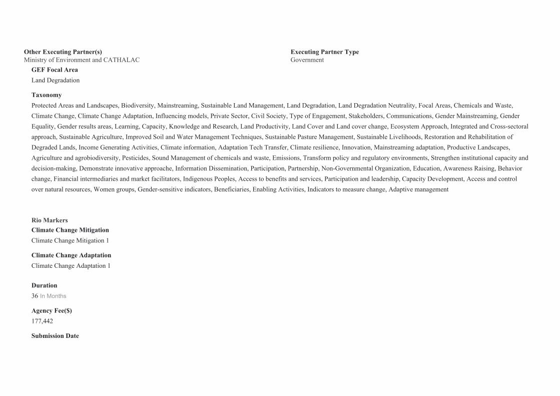
Other Executing Partner(s) Executing Partner TypeMinistry of Environment and CATHALAC Government
GEF Focal AreaLand Degradation
TaxonomyProtected Areas and Landscapes, Biodiversity, Mainstreaming, Sustainable Land Management, Land Degradation, Land Degradation Neutrality, Focal Areas, Chemicals and Waste, Climate Change, Climate Change Adaptation, Influencing models, Private Sector, Civil Society, Type of Engagement, Stakeholders, Communications, Gender Mainstreaming, Gender Equality, Gender results areas, Learning, Capacity, Knowledge and Research, Land Productivity, Land Cover and Land cover change, Ecosystem Approach, Integrated and Cross-sectoral approach, Sustainable Agriculture, Improved Soil and Water Management Techniques, Sustainable Pasture Management, Sustainable Livelihoods, Restoration and Rehabilitation of Degraded Lands, Income Generating Activities, Climate information, Adaptation Tech Transfer, Climate resilience, Innovation, Mainstreaming adaptation, Productive Landscapes, Agriculture and agrobiodiversity, Pesticides, Sound Management of chemicals and waste, Emissions, Transform policy and regulatory environments, Strengthen institutional capacity and decision-making, Demonstrate innovative approache, Information Dissemination, Participation, Partnership, Non-Governmental Organization, Education, Awareness Raising, Behavior change, Financial intermediaries and market facilitators, Indigenous Peoples, Access to benefits and services, Participation and leadership, Capacity Development, Access and control over natural resources, Women groups, Gender-sensitive indicators, Beneficiaries, Enabling Activities, Indicators to measure change, Adaptive management
Rio Markers Climate Change MitigationClimate Change Mitigation 1
Climate Change AdaptationClimate Change Adaptation 1
Duration36 In Months
Agency Fee($)177,442
Submission Date

4/10/2020
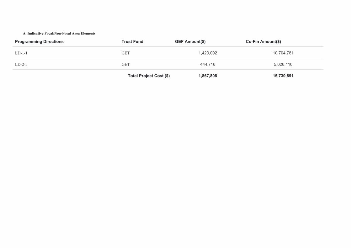
A. Indicative Focal/Non-Focal Area Elements
Programming Directions Trust Fund GEF Amount($) Co-Fin Amount($)
LD-1-1 GET 1,423,092 10,704,781
LD-2-5 GET 444,716 5,026,110
Total Project Cost ($) 1,867,808 15,730,891
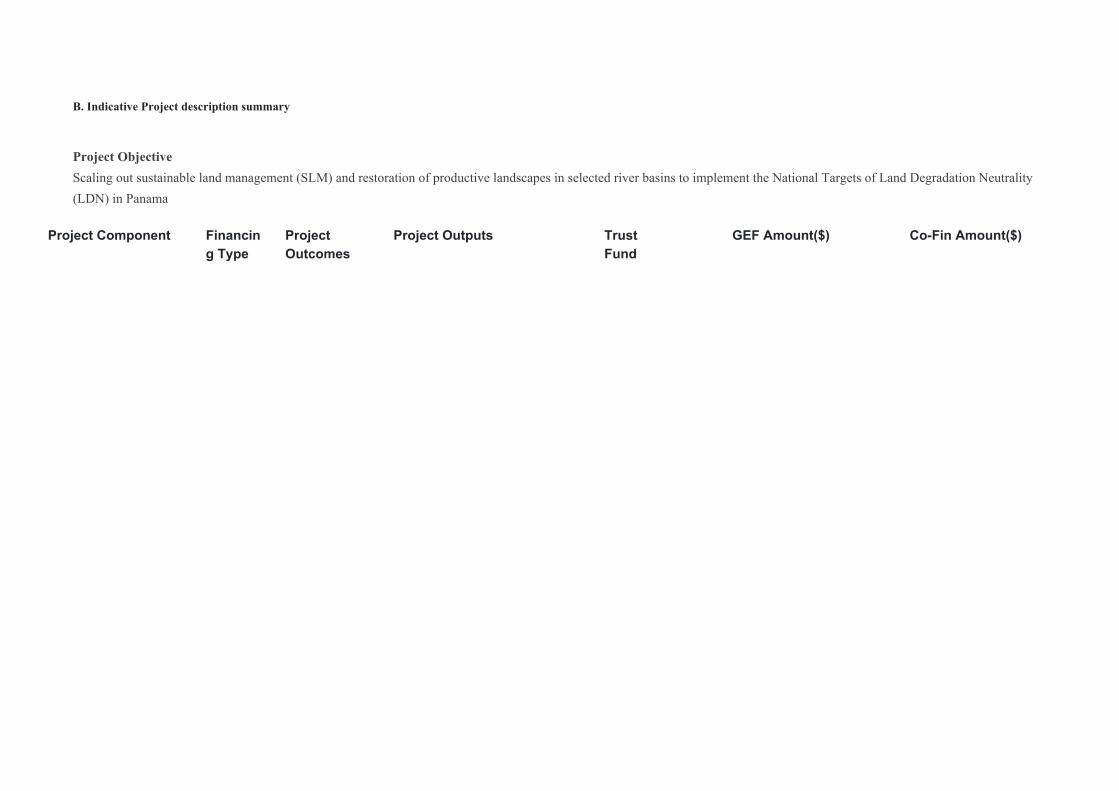
B. Indicative Project description summary
Project ObjectiveScaling out sustainable land management (SLM) and restoration of productive landscapes in selected river basins to implement the National Targets of Land Degradation Neutrality (LDN) in Panama
Project Component Financing Type
Project Outcomes
Project Outputs Trust Fund
GEF Amount($) Co-Fin Amount($)
Project Component Financing Type
Project Outcomes
Project Outputs Trust Fund
GEF Amount($) Co-Fin Amount($)
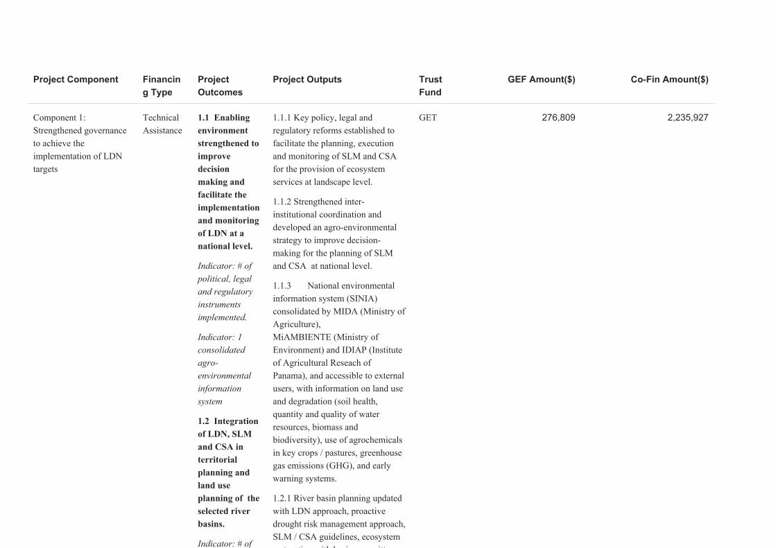
Component 1: Strengthened governance to achieve the implementation of LDN targets
Technical Assistance
1.1 Enabling environment strengthened to improve decision making and facilitate the implementation and monitoring of LDN at a national level.
Indicator: # of political, legal and regulatory instruments implemented.
Indicator: 1 consolidated agro- environmental information system
1.2 Integration of LDN, SLM and CSA in territorial planning and land use planning of the selected river basins.
Indicator: # of territorial plans that integrate better approaches of LDN, SLM and CSA
Indicator: # of local organizations (disaggregated by gender and youth) participating in integrated river basin management and land use planning processes
1.1.1 Key policy, legal and regulatory reforms established to facilitate the planning, execution and monitoring of SLM and CSA for the provision of ecosystem services at landscape level.
1.1.2 Strengthened inter-institutional coordination and developed an agro-environmental strategy to improve decision-making for the planning of SLM and CSA at national level.
1.1.3 National environmental information system (SINIA) consolidated by MIDA (Ministry of Agriculture), MiAMBIENTE (Ministry of Environment) and IDIAP (Institute of Agricultural Reseach of Panama), and accessible to external users, with information on land use and degradation (soil health, quantity and quality of water resources, biomass and biodiversity), use of agrochemicals in key crops / pastures, greenhouse gas emissions (GHG), and early warning systems.
1.2.1 River basin planning updated with LDN approach, proactive drought risk management approach, SLM / CSA guidelines, ecosystem restoration with basin committees, sub-basin committees, promoting municipal co-management and the participation of other local actors
1.2.2 Capacity development program and exchange of experiences with committees of river basin, sub-basin and municipalities, on integrated river basin management, including planning of LDN, SLM and CSA.
GET 276,809 2,235,927
Project Component Financing Type
Project Outcomes
Project Outputs Trust Fund
GEF Amount($) Co-Fin Amount($)
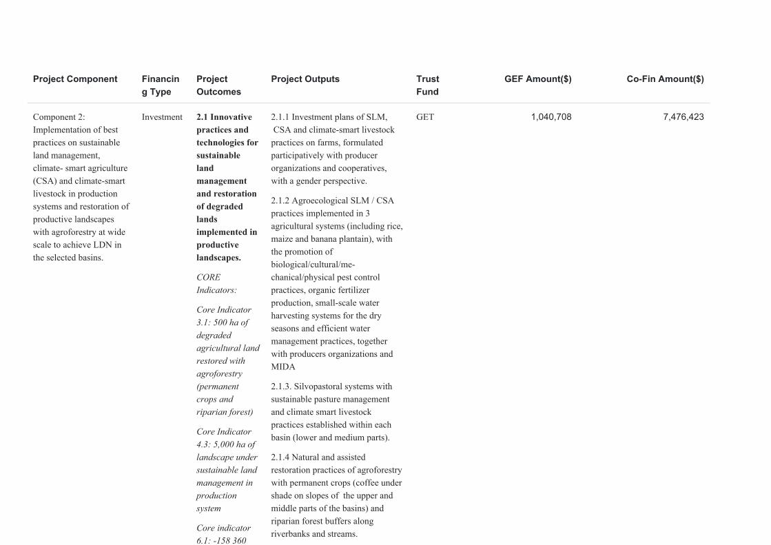
Component 2: Implementation of best practices on sustainable land management, climate- smart agriculture (CSA) and climate-smart livestock in production systems and restoration of productive landscapes with agroforestry at wide scale to achieve LDN in the selected basins.
Investment 2.1 Innovative practices and technologies for sustainable land management and restoration of degraded lands implemented in productive landscapes.
CORE Indicators:
Core Indicator 3.1: 500 ha of degraded agricultural land restored with agroforestry (permanent crops and riparian forest)
Core Indicator 4.3: 5,000 ha of landscape under sustainable land management in production system
Core indicator 6.1: -158 360 tCO2e emissions avoided in the AFOLU sector
2.2 Capacity development and information services to support the planning, implementation and monitoring of SLM / CSA and LDN.
Indicators: # of organizations, including cooperatives and producer associations, with FFS faclilitators (at least 40% women) and youth trained.
Indicator: # of digital technological applications developed and accessible to all producers in the 3 river basins.
2.1.1 Investment plans of SLM, CSA and climate-smart livestock practices on farms, formulated participatively with producer organizations and cooperatives, with a gender perspective.
2.1.2 Agroecological SLM / CSA practices implemented in 3 agricultural systems (including rice, maize and banana plantain), with the promotion of biological/cultural/me-chanical/physical pest control practices, organic fertilizer production, small-scale water harvesting systems for the dry seasons and efficient water management practices, together with producers organizations and MIDA
2.1.3. Silvopastoral systems with sustainable pasture management and climate smart livestock practices established within each basin (lower and medium parts).
2.1.4 Natural and assisted restoration practices of agroforestry with permanent crops (coffee under shade on slopes of the upper and middle parts of the basins) and riparian forest buffers along riverbanks and streams.
2.2.1 Capacity development of local institutions and NGOs , community facilitators and youth on SLM, CSA and sustainable pest management, with gender approach, based on Famers´ Field Schools.
2.2.2 Innovative digital technological applications (environment and climate information) developed to provide timely and reliable advisory and information services to producers (e.g. climate variability, early drought alert, pest advice, etc.), in alliance with the private sector and research centers.
GET 1,040,708 7,476,423

Project Component Financing Type
Project Outcomes
Project Outputs Trust Fund
GEF Amount($) Co-Fin Amount($)
Component 3: Innovative financing mechanisms and access to markets to promote SLM / CSA and land restoration in order to achieve LDN.
Technical Assistance
3.1 Financing mechanisms strengthened in order to mobilize resources to support SLM and CSA practices and ventures in the selected basins.
Indicator: # of strengthened financial mechanisms
3.2 Access to markets and certification mechanisms of agricultural products from SLM areas and restored land promoted.
Indicator: # of cooperatives and women farmers´ associations with access to market for certified commodities from SLM areas and restored land.
Indicator: # key production systems with low carbon and water footprints and low / non agrochemical use strenghtened
3.1.1 Integrated financing strategy to support resource mobilization of the basin committees for the implementation of the portfolio of SLM / CSA and restoration projects.
3.1.2 Ventures and practices on SLM / CSA as well as land restoration incorporated in existing local financing mechanisms (weather based index insurance, agricultural loans, rural savings banks, Water Fund, Protected Areas and Biodiversity) accessible to small producers and women.
3.2.1 Estimations of carbon and water footprints of key commodities in each basin and certification mechanisms (e.g. Panama Footprint) of products with low carbon and water footprints and low use of agrochemicals, to facilitate access to markets.
3.2.2 Strengthened technical and administrative capacities of at least two cooperatives or producer associations (with special emphasis on women's associations) to access markets for value-added products from SLM areas and restored land.
GET 184,539 2,235,927
Project Component Financing Type
Project Outcomes
Project Outputs Trust Fund
GEF Amount($) Co-Fin Amount($)
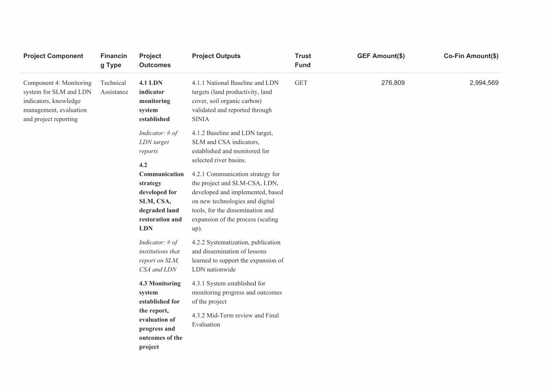
Component 4: Monitoring system for SLM and LDN indicators, knowledge management, evaluation and project reporting
Technical Assistance
4.1 LDN indicator monitoring system established
Indicator: # of LDN target reports
4.2 Communication strategy developed for SLM, CSA, degraded land restoration and LDN
Indicator: # of institutions that report on SLM, CSA and LDN
4.3 Monitoring system established for the report, evaluation of progress and outcomes of the project
4.1.1 National Baseline and LDN targets (land productivity, land cover, soil organic carbon) validated and reported through SINIA
4.1.2 Baseline and LDN target, SLM and CSA indicators, established and monitored for selected river basins.
4.2.1 Communication strategy for the project and SLM-CSA, LDN, developed and implemented, based on new technologies and digital tools, for the dissemination and expansion of the process (scaling up).
4.2.2 Systematization, publication and dissemination of lessons learned to support the expansion of LDN nationwide
4.3.1 System established for monitoring progress and outcomes of the project
4.3.2 Mid-Term review and Final Evaluation
GET 276,809 2,994,569
Project Component Financing Type
Project Outcomes
Project Outputs Trust Fund
GEF Amount($) Co-Fin Amount($)
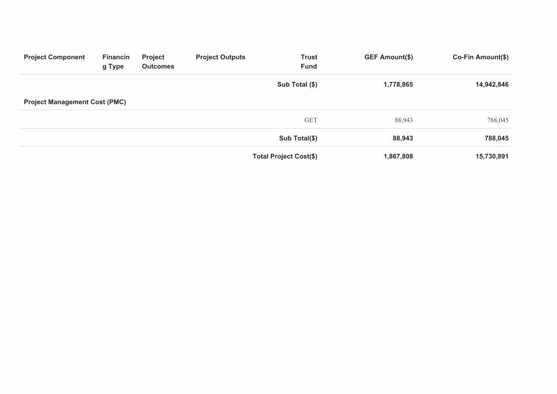
Sub Total ($) 1,778,865 14,942,846
Project Management Cost (PMC)
GET 88,943 788,045
Sub Total($) 88,943 788,045
Total Project Cost($) 1,867,808 15,730,891
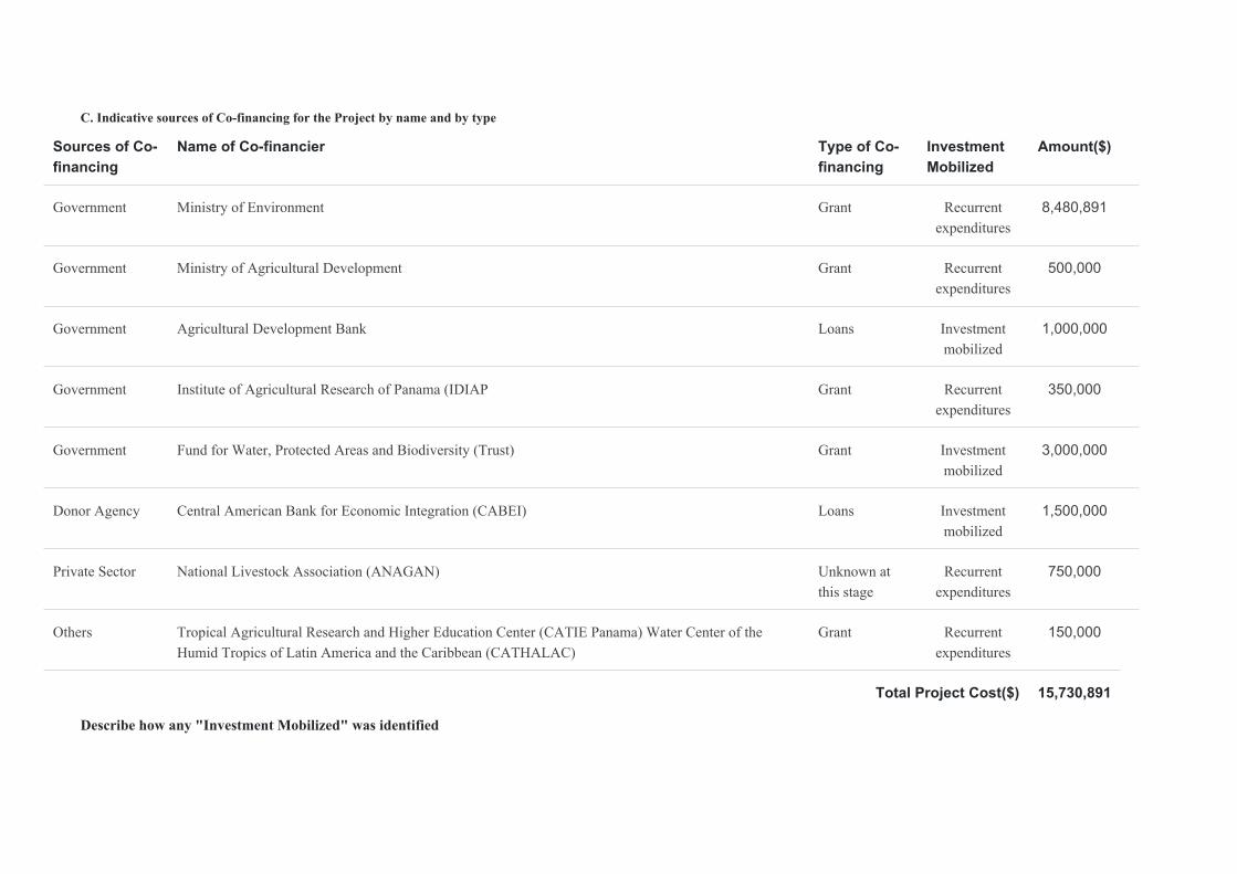
C. Indicative sources of Co-financing for the Project by name and by type
Sources of Co-financing
Name of Co-financier Type of Co-financing
Investment Mobilized
Amount($)
Government Ministry of Environment Grant Recurrent expenditures
8,480,891
Government Ministry of Agricultural Development Grant Recurrent expenditures
500,000
Government Agricultural Development Bank Loans Investment mobilized
1,000,000
Government Institute of Agricultural Research of Panama (IDIAP Grant Recurrent expenditures
350,000
Government Fund for Water, Protected Areas and Biodiversity (Trust) Grant Investment mobilized
3,000,000
Donor Agency Central American Bank for Economic Integration (CABEI) Loans Investment mobilized
1,500,000
Private Sector National Livestock Association (ANAGAN) Unknown at this stage
Recurrent expenditures
750,000
Others Tropical Agricultural Research and Higher Education Center (CATIE Panama) Water Center of the Humid Tropics of Latin America and the Caribbean (CATHALAC)
Grant Recurrent expenditures
150,000
Total Project Cost($) 15,730,891
Describe how any "Investment Mobilized" was identified
BDA will be granting a loan. There will be an specific investment to reinforce the financing of good practices on land management. The Fund for Water, Protected Areas and Biodiversity issues calls for proposals every 12 to 18 months to promote good practices within the project intervention areas. As for CABEI’s financing, the Government of Panama is currently working on a Source to Sea GCF proposal which is expected to scale up this GEF LDN proposal.
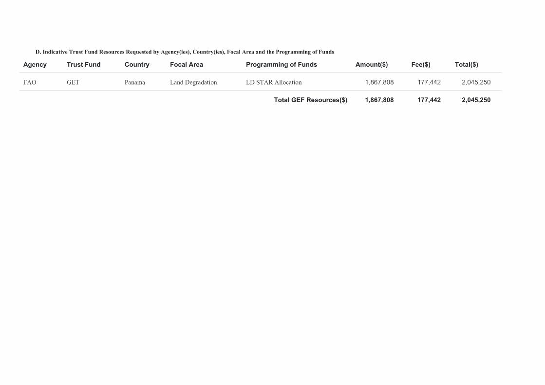
D. Indicative Trust Fund Resources Requested by Agency(ies), Country(ies), Focal Area and the Programming of Funds
Agency Trust Fund Country Focal Area Programming of Funds Amount($) Fee($) Total($)
FAO GET Panama Land Degradation LD STAR Allocation 1,867,808 177,442 2,045,250
Total GEF Resources($) 1,867,808 177,442 2,045,250
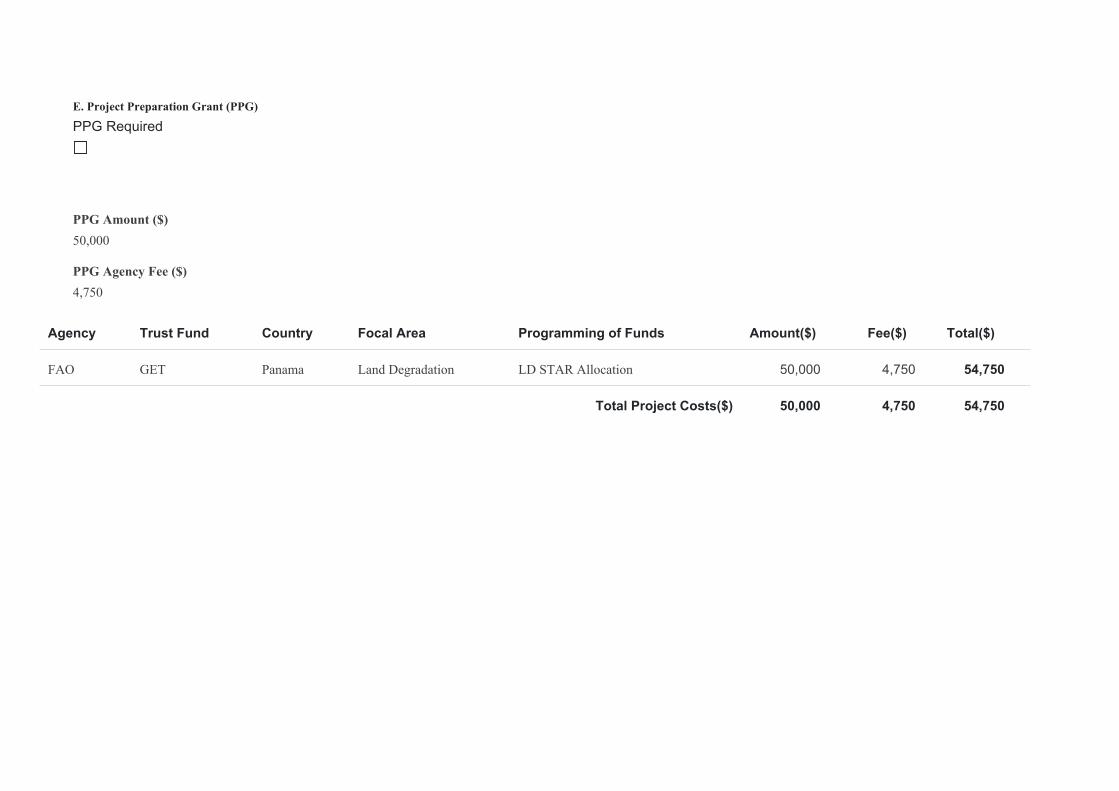
E. Project Preparation Grant (PPG)
PPG Required
PPG Amount ($)50,000
PPG Agency Fee ($)4,750
Agency Trust Fund Country Focal Area Programming of Funds Amount($) Fee($) Total($)
FAO GET Panama Land Degradation LD STAR Allocation 50,000 4,750 54,750
Total Project Costs($) 50,000 4,750 54,750
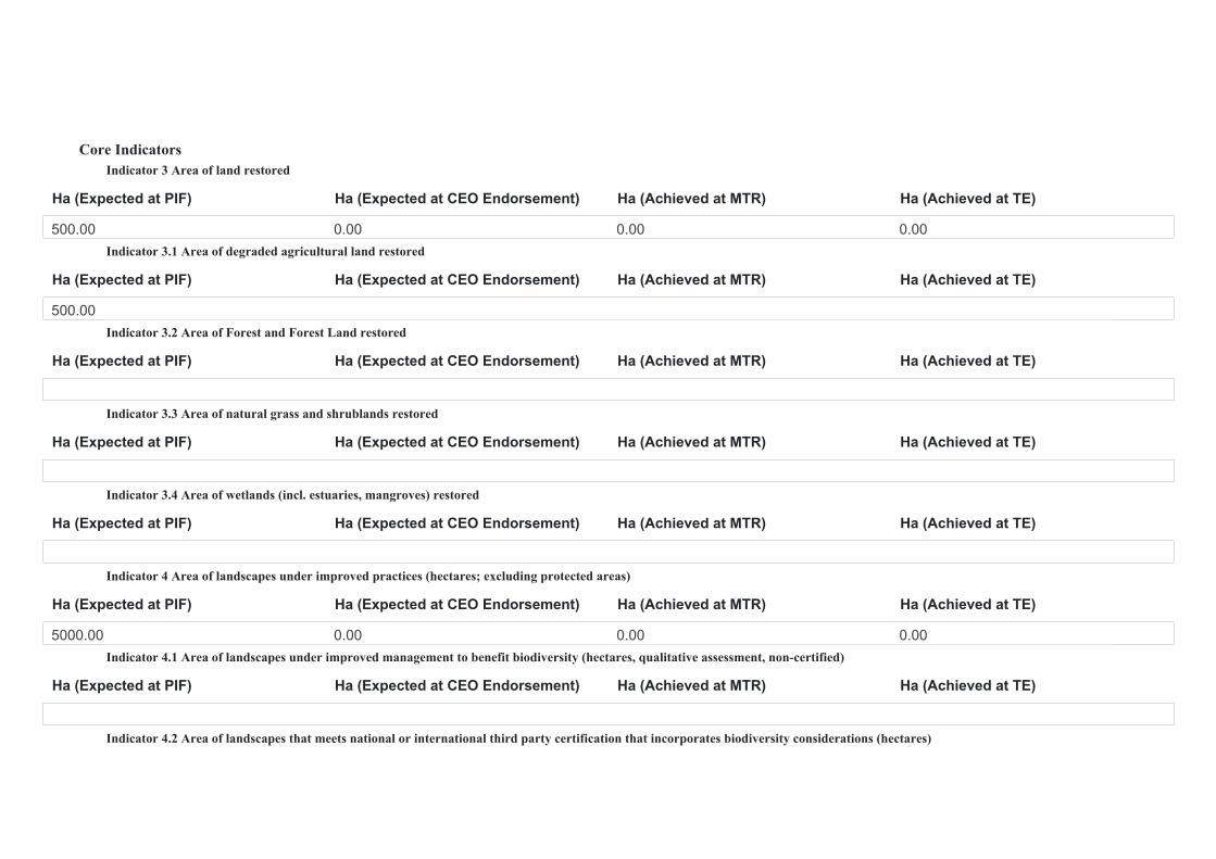
Core Indicators Indicator 3 Area of land restored
Ha (Expected at PIF) Ha (Expected at CEO Endorsement) Ha (Achieved at MTR) Ha (Achieved at TE)
500.00 0.00 0.00 0.00Indicator 3.1 Area of degraded agricultural land restored
Ha (Expected at PIF) Ha (Expected at CEO Endorsement) Ha (Achieved at MTR) Ha (Achieved at TE)
500.00Indicator 3.2 Area of Forest and Forest Land restored
Ha (Expected at PIF) Ha (Expected at CEO Endorsement) Ha (Achieved at MTR) Ha (Achieved at TE)
Indicator 3.3 Area of natural grass and shrublands restored
Ha (Expected at PIF) Ha (Expected at CEO Endorsement) Ha (Achieved at MTR) Ha (Achieved at TE)
Indicator 3.4 Area of wetlands (incl. estuaries, mangroves) restored
Ha (Expected at PIF) Ha (Expected at CEO Endorsement) Ha (Achieved at MTR) Ha (Achieved at TE)
Indicator 4 Area of landscapes under improved practices (hectares; excluding protected areas)
Ha (Expected at PIF) Ha (Expected at CEO Endorsement) Ha (Achieved at MTR) Ha (Achieved at TE)
5000.00 0.00 0.00 0.00Indicator 4.1 Area of landscapes under improved management to benefit biodiversity (hectares, qualitative assessment, non-certified)
Ha (Expected at PIF) Ha (Expected at CEO Endorsement) Ha (Achieved at MTR) Ha (Achieved at TE)
Indicator 4.2 Area of landscapes that meets national or international third party certification that incorporates biodiversity considerations (hectares)
Ha (Expected at PIF) Ha (Expected at CEO Endorsement) Ha (Achieved at MTR) Ha (Achieved at TE)
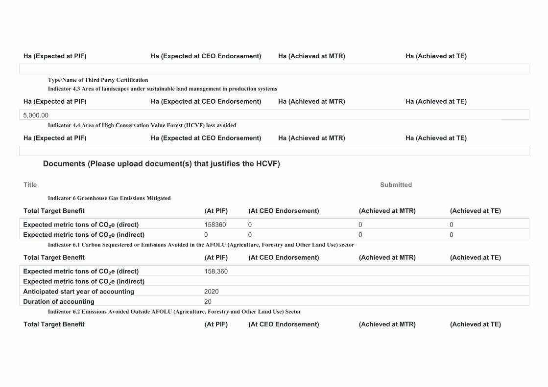
Type/Name of Third Party Certification Indicator 4.3 Area of landscapes under sustainable land management in production systems
Ha (Expected at PIF) Ha (Expected at CEO Endorsement) Ha (Achieved at MTR) Ha (Achieved at TE)
5,000.00Indicator 4.4 Area of High Conservation Value Forest (HCVF) loss avoided
Ha (Expected at PIF) Ha (Expected at CEO Endorsement) Ha (Achieved at MTR) Ha (Achieved at TE)
Documents (Please upload document(s) that justifies the HCVF)
Title Submitted
Indicator 6 Greenhouse Gas Emissions Mitigated
Total Target Benefit (At PIF) (At CEO Endorsement) (Achieved at MTR) (Achieved at TE)
Expected metric tons of CO₂e (direct) 158360 0 0 0Expected metric tons of CO₂e (indirect) 0 0 0 0
Indicator 6.1 Carbon Sequestered or Emissions Avoided in the AFOLU (Agriculture, Forestry and Other Land Use) sector
Total Target Benefit (At PIF) (At CEO Endorsement) (Achieved at MTR) (Achieved at TE)
Expected metric tons of CO₂e (direct) 158,360Expected metric tons of CO₂e (indirect)Anticipated start year of accounting 2020Duration of accounting 20
Indicator 6.2 Emissions Avoided Outside AFOLU (Agriculture, Forestry and Other Land Use) Sector
Total Target Benefit (At PIF) (At CEO Endorsement) (Achieved at MTR) (Achieved at TE)
Total Target Benefit (At PIF) (At CEO Endorsement) (Achieved at MTR) (Achieved at TE)
Expected metric tons of CO₂e (direct)Expected metric tons of CO₂e (indirect)Anticipated start year of accountingDuration of accounting
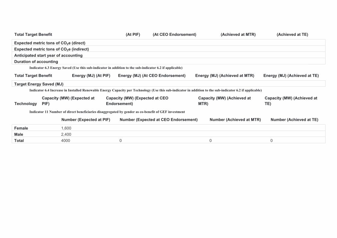
Indicator 6.3 Energy Saved (Use this sub-indicator in addition to the sub-indicator 6.2 if applicable)
Total Target Benefit Energy (MJ) (At PIF) Energy (MJ) (At CEO Endorsement) Energy (MJ) (Achieved at MTR) Energy (MJ) (Achieved at TE)
Target Energy Saved (MJ)Indicator 6.4 Increase in Installed Renewable Energy Capacity per Technology (Use this sub-indicator in addition to the sub-indicator 6.2 if applicable)
TechnologyCapacity (MW) (Expected at PIF)
Capacity (MW) (Expected at CEO Endorsement)
Capacity (MW) (Achieved at MTR)
Capacity (MW) (Achieved at TE)
Indicator 11 Number of direct beneficiaries disaggregated by gender as co-benefit of GEF investment
Number (Expected at PIF) Number (Expected at CEO Endorsement) Number (Achieved at MTR) Number (Achieved at TE)
Female 1,600Male 2,400Total 4000 0 0 0
Part II. Project Justification
1a. Project Description
1. The global environmental and/or adaptation problems, root causes and barriers that need to be addressed (systems description).
1a. Project Description
1. In the last decade, Panama has been one of the fastest growing economies in the world. The average annual growth was 7.2% between 2001- 2013 and 2014-2017, 4.2% in 2018 and 3.5% in 2019, remaining the strongest economy in the Central American region[1]1. However, about one third of the total population[2]2 depends directly or indirectly on agriculture and 39.8% of the population of the rural area of Panama lives in conditions of multidimensional poverty[3]3. This fast economic development associated with social inequity and economic exclusion of the most vulnerable population (among women and rural youth with limited access to productive and financial resources, markets, knowledge and technological innovations), the weakness of governance systems and climate change continue to increase the pressure on natural resources in such a way that there are conditions of apparent shortage of fresh water, degradation of soils, degradation of forests and grasslands and associated loss of biodiversity. The relative importance of these factors varies according to the social and ecological context of the different regions of the country.
2. 37% of the lands in Panama[4]4 are occupied with agricultural activities, although only 25% of them have the capacity to support crops. The Atlas of Dry and Degraded Lands of Panama (ANAM, 2009) states that 27% of the lands have some degree of degradation, with the main direct causes being deforestation, the elimination of vegetation, overgrazing, unsustainable management of crops and pastures and excessive use of agrochemicals. In addition, the National Water Resources Plan (2015 - 2050) reports the degradation of surface and underground water resources, mainly in 10 critical river basins (Chiriquí Viejo, Chico, Chiriquí, Tonosí, La Villa, Santa María, Grande, Anton , Pacora and Bayano), and, according to the relative availability index (IDR), during the dry season months, mainly February, deficit periods are reported in most of the basins, leading to an increase in conflicts over use of water. On the other hand, a large area of forest on the territory has been converted to non-forest production systems. In a period of 50 years,
Panama has lost 1.8 million ha of forests that represent about 25% of forest cover, and it is estimated that the rate of deforestation is 12,166 hectares of forest cover per year. If the trend is maintained, it is expected that by 2038 there will be only 30.6% of forest cover[5]5, which increases the vulnerability of the soil to rains and droughts, runoff, loss of fertile soil, as well as the percentage of sediments in water courses, affecting their quality[6]6. In the same manner, during the last 26 years, the emission associated with the annual rate of deforestation has been reduced from 10 millions to about 5.6 millions of tons of CO2eq[7]7. Loss of forests and vegetation cover are recognized as the main cause of CO2 emissions, and the abandonment of arable land, as the main source of CO2 absorption[8]8.
3. As a result of land degradation in the agricultural sector, the availability of agricultural products and the provision of eco-systemic services (soil fertility, carbon sequestration capacity, recharge of naps and aquifers) have been reduced and the vulnerability to climate change has been increased, with very important social and economic costs for the country. The annual cost of land degradation in Panama is estimated at 309 million dollars (USD), equivalent to 1.5% of the country's GDP[9]9.
4. To combat land degradation, the Panamanian State has established the national targets of land degradation neutrality (LDN) by 2030. One of the main objectives of this proposal is to support the country in the implementation of these targets in priority basins, focusing on the adoption of good practices for sustainable land management and climate smart agriculture in key production systems and restoration of productive landscapes with agroforestry (permanent crops, silvopastoral systems and riparian forest buffer)
Land use and ecosystems in the areas of project execution
5. The project execution areas comprise three river basins covering 594,970 hectares in total, with various ecosystems in the western and central part of the country. These areas include diverse uses of land and landscapes, which integrate protected areas (National Parks Volcán Barú and Santa Fé; forest reserves - La Yeguada and El Montuoso; wetlands - Lagunas de Volcán, Los Pozos de Calobre, Ciénaga de las Macanas), mangroves, marshes and an extensive water network. The Chiriquí Viejo river basin, in its upper and middle part, is formed by mountain ecosystems with 23% of forest cover, 55.5% of agricultural uses and 16.3% of fallow land. It is the main supplier of vegetables in the country (onion, potatoes, legumes), coffee and oil palm for export, a major producer of rice in the lower part, and milk in the middle part. The Santa María river basin, located in the central region, preserves 22.3% of forest cover, 67.6% of agricultural uses and 5.1% of fallow land. The main products are: rice, sugarcane, beef cattle, corn and tubers; in this basin 24.4% of the agricultural land is from subsistence producers. The La Villa river basin, in the south-central part, is a climate region with very low rainfall and tropical dry
forest, considered highly vulnerable to climate change[10]10. It has only 12.7% of forest cover, 43.9% of fallow land and 39.5% of agricultural uses. The main production systems include cattle, rice, corn, melon, beans, watermelon, beans and tubers. At least 100,000 families depend on the productive systems of these basins (See Annex A).
Land degradation and deforestation in project intervention areas[11]11
6. The main causes of land degradation in the execution areas are: loss of forest cover and vegetation cover, overexploitation of natural resources and inappropriate practices of crop and grassland management (e.g. logging, burning, overgrazing, excesive use of agrochemicals and use of soils without productive capacities). This situation is aggravated by climate variability, climate change, forest fires as well a social inequity and economic exclusion of the most vulnerable population (especially the rural woman and youth with limited access to productive and financial resources, markets, knowledge and technologic innovations), and deficiency of territorial planning.
7. In general, land degradation in project execution areas is associated with the lack of sustainability and efficiency of crop and livestock production systems, which has effects on soil erosion, biological soil degradation (e.g. loss of vegetation cover, loss of habitats), chemical soil deterioration (e.g. loss of fertility and loss of organic carbon) and contamination of water resources.
8. In the Chiriquí Viejo river basin, 90% of riparian forests have been lost and the cropping system on mountain lands is responsible for the expansion of the agricultural frontier by eliminating native forests. In the Santa María river basin, the main factor for the loss of gallery forests and native forests is the extensive livestock in the middle and upper middle part of the basin. In the La Villa river basin, the loss of forests has been intense and ongoing, leaving only 12.7% of mature and secondary forests in the upper part of the basin. In the rest of the basin, almost all gallery forests have been lost and water recharge areas have been affected. This situation is aggravated by the lack of specific territorial policies to combat land degradation and stop the fragmentation of habitats; the impact of climate change that increases the vulnerability of ecosystems and productive systems; as well as economic factors such as expansion of monocultures and weak land tenure for large groups of producers.
Ecosystem services and biodiversity in the areas of project execution
9. At long term, the continuous process of degradation of soils, forests and water bodies represents a risk for the conservation of ecosystems with biodiversity of global and national importance in the areas of execution and consequently of the ecosystem services that they provide. Two of the selected watersheds, Chiriquí Viejo and Santa María, are part of protected areas with biodiversity of global importance (La Amistad International Park, World Heritage Site and Biosphere Reserve; Barú Volcano National Park which is part of the La Amistad Biosphere Reserve, and Santa Fe National Park). The first two are part of the Chiriquí Viejo river basin and the last of the Santa María river basin. In the La Villa river basin, protected areas with biodiversity of national importance are located, and highly necessary for the provision of fresh water (El Montuoso Forest Reserve and Cenegón del Mangle wetlands, Cienega de las Macanas). These protected areas provide important environmental services: i) in Chiriquí Viejo, water provision for human, hydroelectric, agroindustry and agricultural consumption and ii) in Santa María and La Villa, water provision for domestic, agroindustry and agricultural consumption. The watershed services do also include the provision of water and regulation of water flow for the mangroves in the lower part of the three basins that constitute the reservoir for the reproduction of marine species (fish, mollusks, crustaceans, etc.) for commercial and artisanal fishing. National parks and La Amistad International Park are among the 10 priority protected conservation areas for Panama (See Annex A).
Climate Change[12]12
10. Although Panama does not contribute significantly to global GHG[13]13 emissions, it is vulnerable to climate change and requires actions to address its adverse effects. According to the 2050 climate scenarios, with respect to the baseline 1981-2014, temperature projections indicate warmer and more extreme conditions, similar to those projected by the IPCC for the mid and late 21st century; As for rainfall, wetter conditions are expected to the east and west of the province of Panama and the Western Region (Chiriquí) and the tendency for the Dry Arc region (Veraguas, Herrera, Los Santos and Coclé) to remain the same or even drier, as well as the Guna Yala[14]14 region. The "National Water Security Plan 2015-2050: Water for All", indicates that both floods due to heavy rains and droughts are the biggest hydroclimatic threats. With more than 90% of rainfed agriculture, the decrease in rainfall will affect the production of onion, rice, banana and corn, as well as livestock in the Dry Arc region; excess rainfall will affect export crops such as melon and watermelon; temperature rise will increase diseases and pests in most crops. In all scenarios, the production of the country's food base will be affected[15]15.
11. Climate variability will have mild to severe impacts in the implementation areas, depending on the structure of the Land Use, Land Use Change and Forestry (LULUCF) sector: i) the Chiriquí Viejo river basin, with 52.3% (70,120 ha) of the land dedicated to agricultural[16]16 activities is prone to landslides and floods: 12.1% (16,260 ha) of the total area of the basin is highly susceptible to landslides; (ii) La Villa river basin has only 12.7% of forest cover and dry climate due to natural conditions, floods and droughts associated with extreme events and poor rainfall distribution have increased; soil erosion, high temperatures in the dry season, the risk of desertification, and water scarcity in rural aqueducts for animal consumption in the dry season, mainly for cattle[17]17; iii) in the Santa María river basin, with 60% of the territory with fallow land and subsistence agriculture, the El Niño phenomenon has intensified periods of drought as well as extended periods of rain, and poor distribution of rainfall in the middle and lower areas, causing damage to production systems, homes and families. The increase in temperature causes stress on plants and animals, affecting yields and deteriorating soils and ecosystem services.[18]18
Use of agrochemicals[19]19
12. Although the excessive use of pesticides and other agrochemicals is associated with contamination and degradation of soil and water, the associated environmental costs (loss of soil productivity, loss of ecosystem services and biodiversity, etc.) are poorly internalized by the producing sector. Records of the National Directorate of Plant Health of MIDA acknowledge that the national productive sector continues to use some high-risk pesticides for public health and the environment (HHP), which are listed in the annexes of the Stockholm Convention (Persistent Organic Pollutants) and the Rotterdam Convention (Prior Informed Consent Procedure)[20]20, including pesticides such as: Alachlor, Aldicarb, Azinphos-methyl, Endosulfan, Trichlorfon, considered PAPs.
13. MIDA, as a competent entity at national level, has taken actions through multiple regulatory standards to ban the importation, use, storage, handling of agrochemicals and their packaging. Through Resolution 74 of 1997, the importation of 61 pesticide active ingredients was prohibited; in 2008 (DE 249 of June 2008) sanitary regulations were established in matter of final disposition of pharmaceutical and agrochemical wastes; and in 2011 (Res. June 11, 2011) the list of 11 prohibited pesticides and 13 reintegrated pesticides was published, among them: Aldicarb and Asynfós-methyl[21]21. In 1997 (Executive Decree of April 19, 1997), MIDA-MINSA coordination was established to regulate the use of pesticides in agriculture and as a matter of prevention of human health. However, improper management of pesticides has affected human health (genetic alterations,
poisoning, allergies, cancer, etc.) among others. Research in banana plantations at Bocas del Toro, in the Atlantic side, evidenced a strong association between the use of Chlorothalonil and occupational dermatosis (Penagos, H. 1991). Earlier in 1983, the sterility in men was associated with the use of Dibromo chloropropane, also used by the banana companies in Panama and Central America, with no results for those affected. It is also known that there have been some affected by Paraquat and Metamilo, without being able to be certified because the statistics (MINSA) are imperfect and no scientific report of the cases was actually recorded. Regarding water pollution, the most popular case was in 2014, the excess of Atrazine[22]22 in La Villa river forced the authorities to close an ethanol and alcohol production company and suspend the water treatment plants for several days. Another effect was the loss of jobs of hundreds of workers due to the closure of the company operations.
14. Estimates on the per capita consumption of agrochemicals (2012-2017)[23]23 revealed levels between 1.66 and 2.83 kg / person, well above the world average (0.6 kg / person), which indicates concentrated use in few crops; most of fertilizers of mineral origin that Panama does not produce. In 2012, the Pesticide Management Plan for vulnerable areas[24]24 was developed, in order to advise producers on the correct use of these agrochemicals, detailing a list of pesticides, separated by classes (herbicides, fungicides, acaricides) and the associated risks of their use as well as the rules of application to avoid damage to human health and biodiversity. Its application was sustained in the areas of execution of biodiversity conservation projects (CBMAP II, SPSCB), however outside of them, no records are kept. Nor are there official records of the number of agrochemicals per crop. Direct consultations with producers and technicians[25]25 on the use of agrochemicals in the areas of project execution, indicate that the crops that use the greatest amount of pesticides per basin are: i) Chiriquí Viejo Basin: vegetables, coffee and pastures in the upper basin; beans, corn, tomatoes, pastures, bananas and rice in the middle and lower basins; ii) Santa María basin: coffee and tomato in the upper basin; watermelon, rice, cane and pastures in the middle and lower basin; iii) La Villa basin: coffee, beans, cassava and yams in the upper basin; Melon, watermelon, squash, chili, corn, tomato, yucca and yam in the middle and lower basin.
Socioeconomic situation
15. Land degradation contributes to maintaining a vicious cycle of poverty and environmental deterioration that tends to worsen, in which thousands of families, small holder farmers and indigenous people, depend on subsistence crops on land with low productivity in production systems with no SLM techniques. For example, in Santa María, 24.4% of the land use corresponds to subsistence agriculture. By 2018, 19.0% of the country's households were multidimensional poor.[26]26 Most are located in degraded areas of the Veragüence Savanna, the Dry Arch (Herrera / Los Santos / Coclé) and high parts of Chiriquí (Highlands, Bugaba) where the selected basins for the implementation of the project are located: Veraguas (17.2%); Chiriquí (11.9); Cocle (19.3%). The low investment in the primary productive base and the protection of natural resources plus the lack of inter-institutional coordination for joint decision-making on how to strengthen the agricultural sector contribute to aggravate the situation of poverty.

Extension Services
16. MIDA has 19 extension agencies (5 in river basin Chiriquí Viejo, 6 in La Villa y 8 in Santa Maria) in the upper, middle and lower parts of the implementation areas, and although extension services on good agricultural practices (e.g. soil conservation) have been carried out for decades, coverage is limited because it is mainly at the level of individual farms. On the other hand, there is a large number of family farmers for whom extension services are limited and who lack the economic capacity to apply the knowledge transmitted to them. It is necessary to develop an agro environmental extension strategy and expand the coverage of assistance at the level of the river basins. It is considered to strengthen the capacities of organizations, susch as cooperatives and producer associations, with the training of their field agents as facilitators (at least 30% women) and youth to conduct the Farmers Field Schools which will allow a wider impact of the SLM techniques proposed herein. In addition, innovative digital technological applications with agro environmental and climate information will be developed to widen the extension and provide timely and reliable information services to the producers.
Financing opportunities and markets
17. Financial assistance for SLM has traditionally been provided by international cooperation with the capacity to benefit a small number of producers. The basin plans do not have associated investments for their implementation and the incentive laws are based on tax benefits that are not attractive to most producers[27]27; 2) there is no capacity of extension agents / producers to prepare bank interest proposals; 3) most micro and small producers and / or do not have bank borrowing capacity; 4) alternative sources of financing (projects, grants, etc.) are insufficient to achieve changes at the territorial level. Small producers have little technical and financial capacity to integrate value chains and they have limited access to markets, [28]28 which discourages the sustainable management of their production systems. FAO's assistance, based on its extensive experience in sustainable production and low carbon emission agriculture, innovative mechanisms to restore degraded landscapes and the ecosystem approach of its interventions, will be very useful for expanding financing opportunities in SLM / CSA in the project.
Institutional Context
18. Government investment plans do not integrate SLM into their budget lines and territorial planning instruments (watershed management plans, land management plans, municipal environmental plans, etc.) are not required to integrate this issue. Consequently, investment plans may be contrary to SLM requirements and promote unsustainable practices. Together with WOCAT, a global network on SLM, FAO has been developing methods and tools for LDN / SDG 15.3 reporting and implementation, identifying status and trands of LDN and SLM at various levels[29]29. At global level, the FAO Land Resources Planning Toolbox contains a comprehensive number of existing tools and approaches that are used to support land resources planning. More specifically, FAO has developed a series of tools that can be applied for quantifying the reduction of GHG emissions (for example: The Livestock Environmental Assessment Model [GLEAM], the Ex Ante Carbon Balance Tool [EX-ACT]) and assessing, monitoring and reporting qualitatively and quantitatively the soil degradation and soil characteristics (e.g. Manual for Local Assessment of Soil Degradation –LADA). For its part, the government has developed various strategies to address this problem, mainly the National Land Degradation Neutrality Strategy and Action Plan 2015-2030 to meet the national targets of LDN and the Desertification Action Program 2015-2025, with initiatives such as the ´Alliance for the Million´ aiming at recovering 1 million ha of forests in 20 years.[30]30
19. Despite these efforts, there are still barriers to integrating SLM and extending its application to a larger scale that relate to the following:
Barrier 1. Weak governance limits the integration of SLM with a cross-sectoral approach (LD, CC and BD) in planning and prevents monitoring of the actions implemented. Faced with the challenges of globalization and integration into international markets, national environmental management shows the following weaknesses: i) reactive management lacking vision and long-term objectives; ii) broad regulations, but dispersed; iii) disintegrated and sectoral management approach (there are no adequate coordination mechanisms); iv) bureaucratic, complicated, slow and expensive operational procedures; v) weak financial and human resources base; vi) non-compliance with regulations by the productive sectors.
The national and territorial planning processes do not integrate SLM with a cross-sectoral approach and the coordination of actions among different public, private and civil society institutions is weak and / or non-existent in many cases. National information management systems lack key data on land degradation (e.g. water quality) and are poorly harmonized; they are not easily accessible by members of the local governments and technicians, impeding them from taking an active participation in the decision-making process related to the integrated water and land use planning of their territories, as well as the monitoring of results. The weak mechanism for information sharing between the government and research organizations do also prevent policy makers for making use of the best available science for their decision making. In addition, the technical standards and the monitoring, control and fiscalisation instruments are inadequate to scientifically evaluate / monitor the changes produced.

Barrier 2. Very localized adoption of SLM / CSA by producers (limited access to improved SLM practices and information/extension services). Institutional efforts are isolated, almost always at the project level, within selected pilot farms, without a strategic landscape approach. Localized action for the protection/conservation of natural resources has ben reducing the opportunities for replication of best SLM /CSA practices outside the project intervention areas (government, academies and research centers). Although there has been a considerable amount of technical information, studies, research, plans and strategies, the wide dissemination and application of this expert knowledge has been very limited. The communication mechanisms are inadequate (not easily accessible to producers) and do not always include information about cost-effective SLM / CSA practices and risk management approaches (droughts, floods, highly hazardous pesticides, market access, etc.) for the protection of environment and health, resulting in little awareness of producers and local authorities about the investment options for sustainable land and water management at the farm level and, even more, at the landscape level. In addition, the current extension[31]31 system doesn´t empower farmers' and communities to take an active part in decision making process for planning and implementing SLM /CSA practices.
Barrier 3. Shortage of innovative financing mechanisms to promote sustainable production systems and integrate SLM / CSA into value chains (low business capacity). At territorial level, financing mechanisms are inadequate to support the required resource mobilization for the implementation of the Basin Management plans with the mainstreaming of SLM / CSA and restoration practices; it is necessary to evaluate potential financial public and private sources to leverage investment for sustainable land management. At farm level, most producers lack financing for SLM / CSA in the traditional credit system (public and private) due to their weak borrowing capacity. Financial assistance for SLM has traditionally been provided by the international organizations with limited funds benefiting a small number of producers. Incentive laws[32]32 are not accessible to all producers and climate resilient tools (such as weather based index insurance or climate-resilient seeds) are lacking in areas of high vulnerability to CC. The traditional credit system often privileges non-sustainable production systems, or is based on non-harmonized public policies that favor unsustainable techniques (monocultures, use of agrochemicals, farm expansion, etc.). In addition, low business management skills of producer organizations and weak national mechanism for the integration of SLM/CSA aproaches into value chains limit access of sustainable agricultural products to domestic and export markets.
Barrier 4. Inadequate knowledge management and LDN monitoring at landscape level. Given that UNCCD has repeatedly mentioned the issue of lack of landscape and local indicators for complementing the global LDN indicators, Panama wishes to contribute to resolving this weakness by supporting the development and monitoring of these indicators through this project. In addition, it is necessary to strengthen the scientific information for validating the baseline of LDN[33]33 and develop the tools for monitoring the results and preparing the country reports.

2. The baseline scenario or any associated baseline programs
20. The government of Panama is aware of the challenges mentioned above and is committed to providing effective response to prevailing problems by improving coordination between sectors and different levels of government, as well as improving national and territorial capacities for the implementation of SLM, strengthening financial mechanisms, technical assistance, extension, and supporting MiAMBIENTE and MIDA in implementing the necessary processes to contribute to the implementation of SLM and sustainable rural livelihoods. Panama has established national LDN targets that will help to give an effective response to the country’s challenges and priorities, including an LDN monitoring system, sustainable, resilient and efficient agricultural production, as detailed in the baseline described in as follows:
• International reference scenario: progress or state of the country in establishing LDN objectives and the country objectives associated with regional or global processes for SLM / SFM or restoration.
National Targets of LDN (2015-2030). Panama submitted the National Land Degradation Targets to 2030 to the UNCCD in 2017, and developed the National Action Plan to Combat Desertification and Drought in Panama (2015-2030) in accordance with the objectives of the CNLCD, laying the foundations to help achieve objective 15 of the SDGs in Panama in its target 15.3. The baseline was developed using the biophysical indicators officially adopted by the UNCCD (changes in land cover, dynamics of land productivity and distribution of soil organic carbon) which must be validated. A first effort in support of Panama’s proposal was developed through the DS-SLM Project with GEF financing. The national LDN targets that are associated with this project are:
• Target 1: At 2030 forest cover has been incremented by 26%.
• Target 2: By 2025: Reduce the conversion of 18,000 ha of forests into fallow land and shrubs and / or agricultural soils.
• Target 3: By 2030: Increase the productivity of 62,000 hectares of agricultural land and 12,000 hectares of scrubland and grassland with decreasing productivity and early deterioration.
• Target 4: By 2020: Improve coordination between different institutions, civil society, unions and promote participatory mechanisms.
• Target 5: By 2020: Improve the existing legal framework so that it would strengthen the LDN program.
Third National Communication on Climate Change (2019). Complying with the UNFCCC commitments, the country has made four GHG inventories for the years 1994, 2000, 2005 and 2010. The first two reported to the UNFCCC in the First and Second National Communication on Climate Change, respectively, and the last two, reported in the Third National Communication (2018). The country presented its Forest Emission Reference Level / Forest Emission Level (NREF / NEF) in 2017 and was approved in 2019. It contemplates the five (5) REDD + activities and reference scenarios. The reference level of Panama was developed under the historical average approach based on the data available for the period from 2000 to 2015. As a result of this analysis, the forest reference level of Panama is 27,735,675.33 t CO2eq and will have a validity period of 5 years from 2016 (2016-2020 period). Panama submitted the first updated Biennial Report to the UNFCCC in 2018.
· National reference scenario: enabling institutional environment, tools and policy instruments
Law 41 of 1998, General Environment Law. Regulates all areas related to the administration, supervision, conservation and protection of the environmental sector and allows compliance with the commitments of international agreements ratified by the country. This law was amended in 2015 and the institutional rank of the Ministry of Environment was raised and given the same responsibilities and powers.
National Water Security Plan: 2015-2050 Water for All. Based on a diagnosis of the situation of water resources in the country developed in a participatory manner with 19 institutions related to the management, protection and administration of water resources, it establishes the challenges, goals and investments that must be faced to guarantee the provision of water in quantity and quality acceptable to all users.
National Strategic Plan with State Vision Panama 2030. Establishes the national objectives and goals to achieve the inclusive development of the government strategic plans aligned with the SDGs having as transverse lines the well-being, transparency, competitiveness, environmental sustainability, social inclusion and productive inclusion.
National Biodiversity Strategy and Action Plan 2018-2050. Establishes the guidelines and actions to ensure that Panama by 2050 reverses the impacts on its biodiversity and ecosystems, currently subject to pressures derived from an economic growth model with high environmental costs, such as the expansion of the urban and agro-livestock frontier or water pollution of rivers and seas.
National Climate Change Strategy to 2050. Guides actions towards a green economy as part of the country’s climate agenda, which should continue to consolidate on the basis of a national public policy that maintains the balance between economic growth, social integration and environmental management as axes that drive compliance with the SDGs.
National Action Plan to Combat Desertification and Drought in Panama. Its objective is to promote actions aimed at preventing, mitigating or compensating the effects of desertification and drought in accordance with the environmental policy guidelines of the Republic of Panama and the international agreements signed. The Plan created the National Committee to Combat Drought and Desertification in Panama (CONALSED) with the goal of complying with the agreements signed by the country within the framework of the UNCCD.
Colmena Plan. The Colmena Plan "Panama free of poverty and inequality, the Sixth Frontier", is a strategy of territorial intervention through the harmonious and integrated articulation of the supply of public services to give priority to those who need it most. [This plan is relevant in a context of post-COVID19 which is further increasing poverty level and associated risks of enviromental degradation in the country].
· Ministry of Environment
National Forest Strategy for 2050 (2019). It is the country’s proposal to increase forest cover, stimulate the sustainable forest industry, conserve our forest heritage as an important base of ecosystems and mitigate the effects of climate change.
Global project on DS-SLM. Between 2015 and 2019, with the technical assistance from FAO, MiAMBIENTE implemented the national component of the global project DS-SLM in Panama. Its objective was to support the decision-making (DS) for the implementation of SLM in two selected basins (Parita and Tonosí). The results and lessons learned from this project have ben used to lay the foundation the PIF GEF-7 and design the proposed outscaling strategy of SLM practices in the Chiriquí Viejo, La Villa and Santa María river basins. In addition, the DS-SLM project developed valuable tools that will be part of the GEF-7 PIF project intervention strategy, such as: i) protocol for national and local assessment of land degradation (including processing of real and historical remote sensing images for updating country information); ii) Farmer Manual, which describes 5 SLM practices applied in 22 pilot farms (farm planning, establishment and management of pastures, establishment of electric fences, on –farm water harvesting systems, and soil conservation measures); iii) design and development of 22 management plans with SLM practices that improved the management of 400 ha in agricultural and livestock farms; iv)
training of youth farmers on the use of drones for the monitoring of degraded land; v) the institutionalization of an annual forum on SLM; vi) collaboration agreement to boost south-south cooperation with Cuban Environmental Agency (AMA).
Alliance for the Million (2014). Its objective is to recover forest cover and generate green jobs that contribute to socio-ecological and economic well-being, national and international, through the production of ecosystem services, the supply of forest goods and services and the fight against climate change. In support of this program, MiAMBIENTE executes the project
Forest Incentives Law (2017). Promulgated to protect, recover and conserve forest cover, in compliance with the objectives of the Alliance for the Million Hectares Reforested and the Sustainable Development Goals by 2030.
National REDD + Strategy. It is part of climate change mitigation actions, aligned with the National Forest Strategy, the sustainable development goals (objective 13 and 15) and the 20x20 initiative.
· Ministry of Agricultural Development
National Climate Change Plan for the Agricultural Sector (2017). It is the instrument of the agricultural sector based on the articulation of strategies, laws and policies to direct public investments of adaptation and mitigation to climate change and maximize the benefits between productive efficiency for food and nutritional security.
Public certification of organic products program (Organic Seal of Panama) 2017. It facilitates access to the producer to the control and certification services required for the sale and promotion of organic products within the national territory, through the Control and Certification Authority of Organic Products of Panama (ACERT).
· Complementary projects and programs in the areas of implementation
Restoration Program for Priority Watersheds for Panama (PROCUENCA). Operation of the MiAMBIENTE / Development Bank of Latin America (CAF) loan for US $ 17.3 million, in support of the Alliance for the Million Program, which began in 2014 and will last 7 years. Its objectives are to recover 1,500 hectares of forest cover in the Chiriquí Viejo, Chiriquí, La Villa, Santa María and Río Grande river basins; train 80 extensionists and benefit 4,600 producers. By December, 10,300 hectares had been reforested.
Water, Protected Areas and Wildlife Trust. Fund created with GEF / BM support as part of the Sustainable Production and Biodiversity Conservation Systems Project (GEF –TF-018972) / GEF Project ID 5546) and MiAMBIENTE’s own resources to create a capital stock of US $ 3.5 million, and fed by current income of MiAMBIENTE and payments for environmental compensation of private companies. Until 2019 it has financed 110 projects for US $ 20.74 million, of which were financed: US $ 2.3 million in reforestation, US $ 0.5 million in adaptation to CC and US $ 0.3 million in water security. Its regulations are currently under modification, and the possibility of opening a specific window to finance SLM / CSA, which will be developed during the PPG phase, is being evaluated.
Climate Change Adaptation Program through Integrated Water Management in Panama / MiAMBIENTE / MIDA / NATURA. Grant to the Adaptation Fund for US $ 9.9 million, executed by NATURA in the Chiriquí Viejo (sub-basin of the Caizán river) and Santa María (sub-basin of the El Gallito river), to design, develop and install an information system on climate change and early warning systems for droughts and floods at the service of producers.
Instruments and interinstitutioal mechanisms for cross-sectorial coordination and territorial planning at national and local levels:
Horizontal coordination
A. National level
It is worthwhile to mention two relevant inter-institutional coordination mechanisms:
- In 2004, the “National Committee to Combat Drought and Desertification in Panama¨ (CONALSED)” was created to comply with the international agreements signed by the country in the framework of the UNCCD. In this instance, Panamá committed itself to promote actions directed to prevent, mitigate or compensate the impacts of desertification and drought. In 2017, as the technical secretariat of CONALSED, the Ministry of Environment has been in charge of leading the process
to establish the LDN targets in the country with the participation of members of governmental institutions, NGOs, academics, international institutions, national and international companies.
- Created in August 2016, the National Council of Water (CONAGUA) is a permanent institution responsible for promoting, orienting, coordinating and ensuring the implementation of the ´National Plan Nacional on Water Security 2015-2050: Water for All´. Since July 2019, the Ministry of the Presidence is chairing it in close collaboration with the Ministry of Environment and other Ministries (Economy y Finance, Health, Agriculture, Autority of the Canal of Panamá, Nacional Administration of the Public Services and the National Institute of Aqueducts and Sewage systems) and the technical support of international organizations (ex: CATHALAC).
At national level, the Ministry of Environment will coordinate the process for the implementation of the LDN targets with the participation of CONALSED and CONAGUA, ensuring the adoption of an integrated land water approach for maximizing environmental and socio-economic benefits.
B. Local level
Watershed planning is governed by Executive Decree 479 of April 23, 2013. In this decree, three necessary tools for watershed planning are indicated. First, the detailed diagnosis of the basin, with criteria related to the physical, social and economic characteristics of these basins. This diagnosis is used as input to prepare the territorial environmental planning plan (POAT), instrument for planning, evaluation and control of human activities compatible with the use and management of the natural resources of the territory of the hydrographic basin. Subsequent to the preparation of the POAT, the decree foresees the formulation of a Plan for the management, development and adaptation of the hydrographic basin, which operationalizes the provisions of the POAT identifying the activities that can be carried out, their conditions and characteristics.
At local level, the Ministry of Environment is the institution in charge for the formulation of these detailed diagnosis and POAT, these instruments are perceived as the sole competence of this institution without taking into account the sectoral implications that this instrument may have. For the implementation of the Basin Management Plan, there is the Basin, sub-basin and micro-basin Committees. Within the conformation of these committees at a more territorial level, if a multisectoral conformation is considered depending on the needs of the basins.
Vertical coordination
The Ministry of Enviroment will not only have a key role to ensure the horizontal co-ordination for the LDN implementation at all levels but it will also have a key role to facilitate the vertical coordination from local to national level for fostering policy alignment, complementarities, co-operation and reporting on LDN across all levels.
3) Alternative scenario – expected results and project components
21. The purpose of this project is to support the implementation and monitoring of the Land Degradation Neutrality targets, by adopting a landscape approach, seeking the promotion and facilitation of the implementation of sustainable land management (SLM) and Climate-smart agriculture (CSA) to combat land degradation, agrochemical residues, biodiversity conservation, the generation of ecosystem services and the development of resilience in productive landscapes. The project will work at two levels: nationally and in 3 selected river basins (Chiriquí Viejo, La Villa and Santa María).
22. The project consists of 4 components formulated to support the implementation of sustainable land management (SLM) and climate-smart agriculture (CSA) and thus achieve LDN implementation and targets. The components cover the following aspects (i) Strengthened governance; (ii) Implementation of SLM / CSA practices; (iii) innovative financial mechanisms and (iv) knowledge and information management. The set of components, expected outcomes, products and activities of this project will strengthen a comprehensive approach to landscape management in territorial planning to facilitate the implementation of sustainable land management and mitigation practices, as well as adaptation to climate change, to at the same time, capacities will be developed and tools will be created to strengthen political, planning and financial decision making.
23. The three river basins represents a relatively important territory with a large population. Through a stakeholder consultation process, on the basis of a comprehensive set of selection criteria, key municipalities and producers of the three river basins will be selected. Potential selection criteria already preliminary identified include: location of at at least one municipality in each part of the river (sub-)basins (upper, medium and lower parts), relative importance of slected land use systems and potential for land use change, potential for value chain development based on the presence of private sector (companies and cooperatives) and local organizations (women´s organizations), municipalities identified as a priority by key national plans (e.g. plan Colmena – relavant for post-Covid19) for poverty alleviation and food security of smallholder farmers, …
24. Given that the total number of producers is not expected to be more than 20,000 in the three river basins and it can be assumed that one producer supports a household of 4 members, the total number of project beneficiaries (4000 direct beneficiaries, including 1000 producers) will represent about 5% of the potential direct beneficiaries in the

project intervention area (see Table 1 ´Project implementation area – demographic data of the selected river basins´). In addition, the project will target about 2% of the total area under production systems (about 273, 567 ha of crops, pastures and agroforestry) in the three river basins (see Table 2 – Physical description of selected river basins).
The components and expected outcomes of the project are the following:
Component 1: Strengthened governance to achieve the implementation of LDN targets
This component will be carried out in order to strengthen multi-scale governance, at the national and territorial levels, in the three selected river basins. The strengthening of the enabling environment will allow the promotion of land use planning wich will anticipate future land degradation (losses) and plan positive actions of sustainable land management (gains) with better inter-institutional coordination, as well as articulation and coherence of approaches between the various levels (Barrier 1). Component 1 will comprise the following expected outcomes:
Expected Outcome 1.1. Enabling environment strengthened to improve decision making and facilitate the implementation and monitoring of LDN at the national level
This outcome will enhance policy coherence to facilitate LDN implementation, through reforming key policies, laws and norms that are hindering SLM, strengthening inter-institutional coordination between the Ministries dealing with the agricultural and environmental sectors and designing an agri-environmental strategy, with the participation of other relevant sectors. In this context, a mainstreaming strategy will be developed to integrate SLM/CSA and LDN approaches to key decision-making processes to achieve LDN.
Specific legal and normative reforms will target current inadequate instruments that have been causing land degradation and promoting perverse schemes. These instruments include, for instance, (i) the granting of higher credits by the Agricultural Development Bank to those who demonstrate a larger deforested area; (ii) the Norm on Riparian forests stipulates that the wider the river, the wider the riparian forests should be—the result of this norm is that in mountainous areas (where the river is narrow) a narrower riparian forest is established, contrary to what is required to provide protective functions and ecosystem services; while downstream (where the river is larger) farmers have to devote a large area of more fertile soils to riparian forests. Also, the strengthening of legal reforms will include the formulation and approval of a new law for sustainable soil/land management.
The development of a mainstreaming strategy will facilitate the integration of the LDN approach into key decision-making processes, including planning and financing mechanisms at all levels, under a bottom-up approach. This will facilitate the planning, execution and monitoring of SLM and CSA for the provision of ecosystem services at landscape level.
An agri-environmental strategy will be developed through enhancing inter-institutional dialogue and coordination between the ministries dealing with environment and agricultural sectors, as well as other relevant sectors such as economy, trade, science, etc., with the participation of other relevant actors (academy, public research entities, private sector, etc.).
Expected Outcome 1.2 Integration of the LDN, SLM and CSA in the territorial and land use planning of the selected river basins
Land use planning will be strengthened in three selected river basins, by integrating practices of SLM and CSA into territorial planning instruments (river basin management plans and municipal plans), adopting LDN and proactive drought risk management approaches. This will be done through strengthening the capacities of the municipalities, basin and sub-basin committees which are key organizations for cross-sectorial planning and coordination of various Government institutions within the territory. The integration of other actors, mainly local producers and community-based organizations, into this process, will be key as producers are underrepresented in basin committees for ensuring the sustainable management of natural resources.
Project will assist in developing policy instruments and planning tools to promote agroforestry for landscape restauration. Three systems have been identified as most suitable for landscape restauration: agroforestry with permanent crops, silvo-pastoral systems and riparian forest. At the end of project, cost-effective models for agroforestry restauration will have been designed and integrated into river basin and farm investment plans. Panama is also working on GCF investment project that includes a ´source to sea´ approach. Forest restauration in the upper and lower parts of the basin will be carried out in a complementary manner by this GCF project in the Santa María Basin (located in the centre of the project intervention area).
Component 2: Implementation of practices on sustainable land management and climate- smart agriculture in production systems as well as restoration of productive landscape with agroforestry systems, at wide scale, to achieve LDN in selected basins.
Component 2 will directly support the implementation of a series of SLM practices in the mosaics of land uses currently underway in the river basins. The practices will be implemented in agriculture, livestock and forestry systems to prevent land degradation, reduce land degradation and restore degraded land (LDN) while promoting sustainable, healthy and resilient livelihoods and reducing greenhouse gas emissions (GHG). A key element of this component will be to strengthen the capacities of producers, organizations and cooperatives, for the planning and implementation of improved systems and practices through access to reliable information services ad more effective extension systems (Barrier 2). For this purpose, Component 2 will consist of the following expected results:
Expected Outcome 2.1 Innovative practices and technologies for sustainable land management and restoration of degraded lands implemented in productive landscape
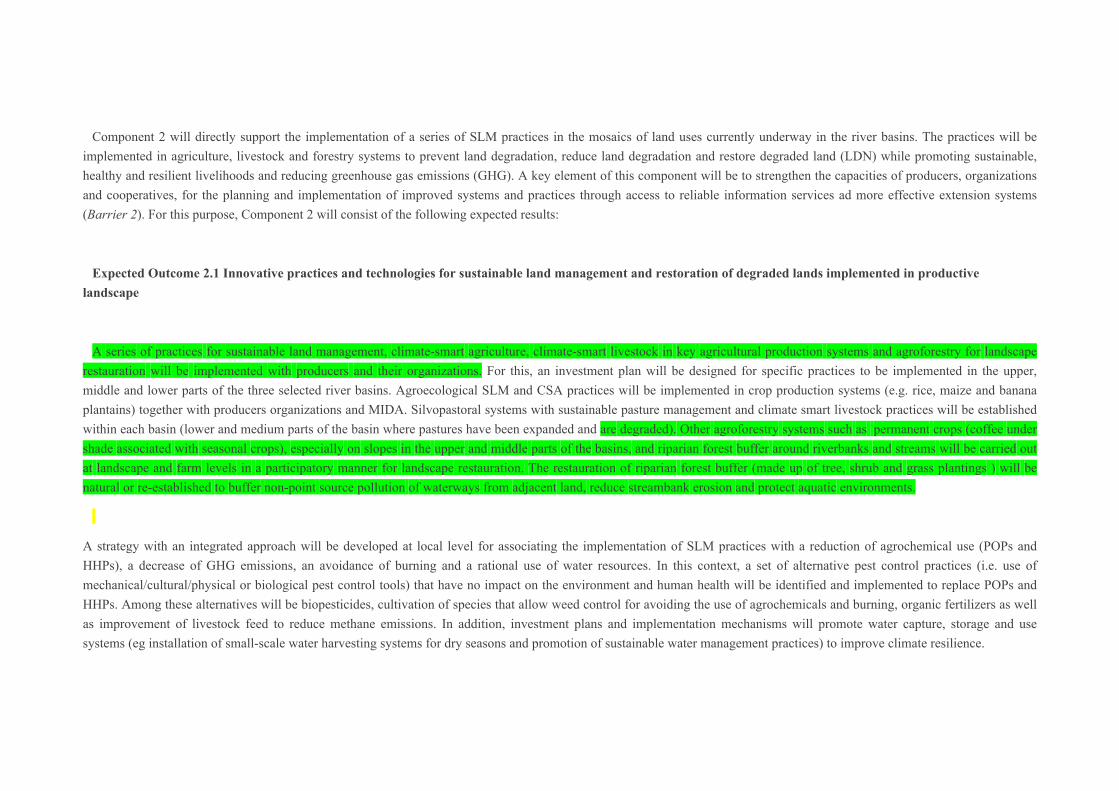
A series of practices for sustainable land management, climate-smart agriculture, climate-smart livestock in key agricultural production systems and agroforestry for landscape restauration will be implemented with producers and their organizations. For this, an investment plan will be designed for specific practices to be implemented in the upper, middle and lower parts of the three selected river basins. Agroecological SLM and CSA practices will be implemented in crop production systems (e.g. rice, maize and banana plantains) together with producers organizations and MIDA. Silvopastoral systems with sustainable pasture management and climate smart livestock practices will be established within each basin (lower and medium parts of the basin where pastures have been expanded and are degraded). Other agroforestry systems such as permanent crops (coffee under shade associated with seasonal crops), especially on slopes in the upper and middle parts of the basins, and riparian forest buffer around riverbanks and streams will be carried out at landscape and farm levels in a participatory manner for landscape restauration. The restauration of riparian forest buffer (made up of tree, shrub and grass plantings ) will be natural or re-established to buffer non-point source pollution of waterways from adjacent land, reduce streambank erosion and protect aquatic environments.
A strategy with an integrated approach will be developed at local level for associating the implementation of SLM practices with a reduction of agrochemical use (POPs and HHPs), a decrease of GHG emissions, an avoidance of burning and a rational use of water resources. In this context, a set of alternative pest control practices (i.e. use of mechanical/cultural/physical or biological pest control tools) that have no impact on the environment and human health will be identified and implemented to replace POPs and HHPs. Among these alternatives will be biopesticides, cultivation of species that allow weed control for avoiding the use of agrochemicals and burning, organic fertilizers as well as improvement of livestock feed to reduce methane emissions. In addition, investment plans and implementation mechanisms will promote water capture, storage and use systems (eg installation of small-scale water harvesting systems for dry seasons and promotion of sustainable water management practices) to improve climate resilience.
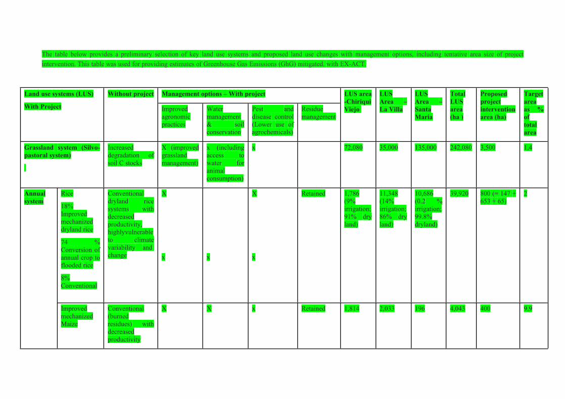
The table below provides a preliminary selection of key land use systems and proposed land use changes with management options, including tentative area size of project intervention. This table was used for providing estimates of Greenhouse Gas Emissions (GhG) mitigated. with EX-ACT.
Management options – With projectLand use systems (LUS)
With Project
Without project
Improved agronomic practices
Water management & soil conservation
Pest and disease control (Lower use of agrochemicals)
Residue management
LUS area -Chiriqui Viejo
LUS Area – La Villa
LUS Area – Santa Maria
Total LUS area (ha )
Proposed project intervention area (ha)
Target area as % of total area
Grassland system (Silvo-pastoral system)
Increased degradation of soil C stocks
X (improved grassland management)
x (including access to water for animal consumption)
x 72,080 35,000 135,000 242,080 3,500 1,4
Rice
18% Improved mechanized dryland rice
74 % Conversion of annual crop to flooded rice
8% Conventional
Conventional dryland rice systems with decreased productivity, highlyvulnerable to climate variability and change
X
x
x
X
x
Retained 1,786 (9% irrigation; 91% dry land)
11,348 (14% irrigation; 86% dry land)
10,686 (0.2 % irrigation; 99.8% dryland)
39,920 800 (= 147 + 653 + 65)
2Annual system
Improved mechanized Maize
Conventional (burned residues) with decreased productivity
X X x Retained 1,814 2,033 196 4,043 400 9,9

Improved – shaded coffee (under agroforestry system)
Actual coffee with losses due to extreme weather events and pests
X (improved resilience to extreme weather events)
x X No burning of residue
2,000 - 969 2,969 500 16,8Perenial system
Banana plantain
48% agroforestry system (Multistrata systems)
52% grown in plantations (monoculture)
60% : monoculture
40%: agroforestry system, with increase contamination of water source by agrochemicals
x No residue burning
5,942 - - 5,942 300 5
Sources of data of LUS : river basin: River basin management plans of Chiriqui Viejo, Santa Maria and La Villa
Some of the assumptions related to land use change have been made for the compilation of the above table, including:
1. Grassland system :
100% of grassland systems converted to silvo-pastoral system (other land use cover ´OLUC´)
Degradation of 5% of biomass and carbon stock (Panama's stock of carbon is 36.23tC / ha)
2. Rice production system
Improved management of 20% dryland systems (´rainfed upland rice ecosystems´ without ponding)
80% dryland systems converted to ´flooded rice´ (complementary irrigation by flooding with diversion of river water or pumping of water from reservoirs)
Rice under irrigation systems will remain irrigated with the ´Systems Melgas´ (small scale irrigation schemes with ´basin irrigation´)
3. Perennial system : Banana plantain
20% of monocultures will be converted to agroforestry systems (multistrate systems) with the project.

4. Perennial system: Coffee
100% of coffee is managed under or in between overstorey shade trees
Remarks: Different percentages were used according to crop type, type of producers (large, medium or small) and the opportunities to make effective changes in their production systems. During the PPG, the assumptions, the management options and proposed areas will be validated and further defined with all stakeholders.
Expected Outcome 2.2. Capacity development and information services to support the planning, implementation and monitoring of SLM / CSA and LDN
The scaling out of practices will be supported by a capacity development program based on the Farmer Field School approach where producers make improvements to their farms through discovery-based learning. This will strengthen the capacities of producers, organizations and cooperatives for the planning and implementation of approaches (SLM, CSA, climate smart livestock and sustainable pest management) and associated practices, which will be carried out with a gender perspective. The participatory training programme will include the design of a curriculum for Field Schools (FFS) with subject matter specialists from national universities and the training of field agents from various organizations. In addition, the development of innovative digital technological applications will increase access to environment and climate information, with the aim to strengthen local decision making and risk management of producers, technicians and other actors.
Component 3: Innovative financing mechanisms and access to markets to promote SLM / CSA and land restoration, in order to achieve LDN targets.
The third component of the project seeks to strengthen the mobilization of resources for the implementation of projects, initiatives and practices of SLM / CSA and restoration of the basins through its integration into existing financial mechanisms, such as the water fund and certification schemes. This component will allow support to solve the limited access to financing and knowledge to develop sustainable value chains (Barrier 3).
Expected Outcome 3.1 Financing mechanisms strengthened to mobilize resources that support SLM and CSA practices and ventures in the basins
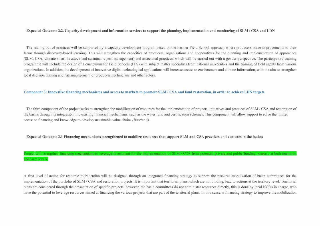
Project will strengthen financing mechanisms to leverage investment for the implementation of SLM / CSA from potential private and public funding sources, at both territorial and farm levels.
A first level of action for resource mobilization will be designed through an integrated financing strategy to support the resource mobilization of basin committees for the implementation of the portfolio of SLM / CSA and restoration projects. It is important that territorial plans, which are not binding, lead to actions at the territory level. Territorial plans are considered through the presentation of specific projects; however, the basin committees do not administer resources directly, this is done by local NGOs in charge, who have the potential to leverage resources aimed at financing the various projects that are part of the territorial plans. In this sense, a financing strategy to improve the mobilization

of resources from various sources and existing compensation mechanisms will be developed in support of the development of territorial plans. The design of the financing strategy will include the identification of various existing and potential financing mechanisms and sources, including mechanisms of corporate environmental responsibility, private sector, compensation and MiAmbiente Trust. For instance, a concrete opportunity exist to include specific SLM criteria into the national Water Fund, in collaboration with CONAGUA, to finance SLM / CSA interventions. In addition, the project will seek synergies and complementarities with other large projects on climate finance (GCF). Forest restauration in the upper and lower parts of the basin will be carried out by a GCF project in the Santa María Basin (located in the centre of the project intervention area.
The second level of intervention will seek to incorporate SLM / CSA ventures and practices into existing local financing mechanisms (eg. agricultural loans, rural savings banks, water fund and weather based index insurance). For this purpose, agreements will be established with local financial intermediaries (FIs), such as the Agricultural Development Bank (BDA) and the community rural banks, in order to engage them in the financing of companies, cooperatives and producer organizations that contribute to the achievement of LDN. This will be carried out by collaborating with financing intermediaries on developing investment portfolio on SLM / CSA and tools to facilitate the granting of credits at preferential rates to producers who implement SLM / CSA practices and restoration. The strengthened financing mechanisms will contribute to long term financial resource mobilization, with greater accessibility for smallholder producers and women. At this level, smallholder farmers (especially women) will be organized and receive support from cooperatives which will play an instrumental role to provide access to information services, financing and markets for their members. Therefore, farmers will be able to make more informed and secure investment in SLM/CSA practices for key commodities. Their capacities will be strengthened to elaborate farm business models with application of tools, such as Rural Invest, in order to facilitate access to credits and increase investment into SLM practices during the project duration of 3 years.
Expected Outcome 3.2 Access to markets and certification mechanism of products from SLM / CSA areas and restored land
This expected outcome seeks to increase access to domestic and export markets of agricultural products from SLM areas and restored land. It will strengthen the national certification mechanism (e.g. Panama Footprint) to interate and reward the application of SLM, CSA and sustainable pest management approaches.
The initiative ´Panama Footprint´, being proposed by MiAMBIENTE, aims at a. linking the reduction of GHGs and HHPs and the rational use of water, b. promoting the aggregation of value to products and, at the same time, c. increasing access to export markets. This initiative would be supported by public purchases from national associations of producers of organic fertilizers and biopesticides, for the gradual replacement of agrochemicals.
In the framework of the ´Panama Footprint´, national capacities will be strengthened to estimate the carbon footprint equivalent and water footprint of key commodities in each river basin. Activities will include training on tools and methodologies for the calculation of GHG emissions and removals (GHGProtocol and EX-ACT) within each production system. In addition, the national certification mechanism will be strengthened to certify products with low carbon and water footprints and low use of agrochemicals in the basins.
Furthermore, the technical and administrative capacities of at least two cooperatives or producer associations to access financing and markets will be strengthened. Priority will be given to women’s associations for achieving this result.
Component 4. Monitoring system for SLM and LDN indicators, knowledge management, evaluation and project reporting
The last component addresses the issues of monitoring and knowledge management, through the development of an indicator monitoring system and a communication strategy, which together will help to solve the lack of information that exists in areas that have been qualified as critical on land degradation (Barrier 4).
Expected Outcome 4.1 LDN indicator monitoring system and other indicators at the established landscape level
A monitoring system of the LDN indicators and additional SLM / CSA indicators will be established at the landscape level. The LDN baseline will be validated and other indicators will be used and monitored at landscape level (such as rehabilitated areas of previously degraded agricultural land, sustainable pasture management areas and sustainable agriculture areas with improved SLM practices that benefit biodiversity and GHG mitigated emissions).
Expected outcome 4.2 Communication strategy developed on SLM, CSA, rehabilitation of degraded lands and LDN
From the beginning of the project, the communication strategy would be support the systematization and dissemination of the process and lessons learned in order to support the expansion of LDN nationwide. It would focus on supporting the dissemination and expansion of the results of the project (scaling up) on SLM, CSA and LDN through new technologies and digital tools. This strategy will support the ´dissemination plan on SLM´ being prepared by MiAmbiente.
Expected Outcome 4.3 Monitoring, reporting and evaluation of the progress and established outcomes of the project
Project monitoring, reporting and evaluation system will be carried out as in other GEF projects.
4) Alignment with GEF focal areas and / or with the Impact Program
25. The project includes several GEF focal areas, the main one being the Land Degradation, in its Objective 1. Support the implementation of sustainable land management to achieve LDN, specifically Objective DT 1-1: Food systems, use of land and restoration of productive landscapes to preserve food production and livelihoods through sustainable land management; and Objective 2. Create an enabling environment to support the implementation of national LDN targets, specifically Objective DT 2-5: Create enabling environments to support the expansion and incorporation of sustainable land management, applying LDN as strategy to facilitate the fulfillment of these targets.; aligned with the focal area of Climate Change with Objective 2. Demonstrate options for mitigating systematic impacts, specifically, with Objective 2.2 Program on Impact on Food Systems, Land Use and Restoration; and with the focal area of Biodiversity with Objective 1.1 Integrate biodiversity into productive landscapes. The project will contribute to achieving the Sustainable Development Goals: 1 (No Poverty), 5 (Gender Equality), 6 (Clean Water and Sanitation), 10 (Reduced Inequalities), 12 (Responsible Consumption and Production), 13 (Climate Action) and 15 (Life on Land).
26. Moreover, the project will contribute to support Panama in achieving its national land degradation targets (LDN), through a strategy that supports the restoration of degraded land with an eco-systemic approach for achieving the multiple environmental and socio-economic benefits of SLM, using the watershed as a landscape unit. The project will also contribute to improving coordination between different institutions, civil society, unions and promoting participatory mechanisms; facilitate the integration of sustainable land management techniques (soil, water and biological resources) to promote sustainable and resilient food systems that contribute to the restoration, prevention and detention of degradation processes and regulate the management and use of highly hazardous agrochemicals as a factor that affects the chemical degradation of land and its impacts on the soil and water. The joint actions of the project are expected to create synergies between the objectives of the conventions (UNCED, UNFCCC, UNCLOS, UNCCD) and global agreements for the reduction of agricultural chemicals and provide national and global environmental benefits.
5) Incremental/additional cost reasoning and expected contributions from the baseline, the GEFTF, LDCF, SCCF, and co-financing.
The GEF incremental investment will build on and complement the baseline and co-financing initiatives of MIAMBIENTE, MIDA, IDIAP and the institutions involved in the River basin committees and sub-committees. It will address the barriers found through improved governance, development of cross-sectoral strategies at national level, integration of landscape approach into sectoral and cross-sectoral territorial planning, improved mobilization of resources from existing financing mechanism for sustainable land management, climate smart agriculture and restoration of riparian forests and ecosystem services, as well as strengthening capacities of territorial institutions.
27. GEF incremental financing. The incremental financing of the GEF will contribute to support the implementation and mainstreaming of SLM with a landscape approach into policy, planning and investment frameworks, with widescale interventions in the field and market access in order to support Panama in the achievement of the LDN targets within the selected basins. Panama has made significant advances to improve sustainable land management, including the definition of the LDN targets by 2030 before the UNCCD, which will allow measuring changes in the land productivity, land cover and increase or decrease in carbon reserves, with the aim of fulfilling multiple SDGs, among these: End Poverty (SDG 1); End Hunger, Achieve Food Security and Improvement of Nutrition and Promote Sustainable Agriculture (SDG 2); Adopt urgent measures to combat climate change and its effects (SDG 13); and Sustainably manage forests, combat desertification, stop and reverse land degradation, and stop biodiversity loss (SDG 15). These actions are consistent with the UNREDD+ Strategy of the country in terms of biodiversity, climate change, combat desertification and drought; as well as framework conventions signed by Panama, among these: UNCCD, UNFCCC, CBD.
28. This new and complex objective of Panama will be supported by the GEF so that the actions of MiAmbiente and MIDA, key entities in the restoration of degraded landscapes, are not dispersed with public policies that may be contradictory and / or that the necessary inter-institutional coordination to achieve the targets of LDN is not achieved. The project approach strategy favors the ecosystem approach, specifically in priority watersheds of environmental, economic, social and territorial importance for Panama. In addition, it fosters an intersectoral intervention of SLM / CSA in productive landscapes, with a closer collaboration between institutions, producer organizations, local governments and the private sector.
The rationale for incremental costs for each component is presented below.
Component 1: Strengthened governance to achieve the implementation of LDN targets (linked to Barrier 1). GEF's support for this component, under Objective 2 of the LD Focal Area Strategy, is intended to strengthen decision-making based on evidence of the importance and impacts of SLM / SFM practices in tropical ecosystems, and thus
generate information and data on the targets of LDN and the link between SLM, CSA and the loss of biodiversity to achieve the country's objectives, facilitating the necessary synergies for institutions to comprehensively address the issues of land degradation, biodiversity, carbon, water, climate change and the way in which residents are affected or benefited by these practices. The strengthening of governance will provide incremental benefits to the existing environmental and agricultural governance as the support of GEF will establish key policy, legal and regulatory reforms to facilitate the planning, execution and monitoring of SLM and CSA for the provision of ecosystem services at landscape level. Also, under the leadership of the Ministry of Environment, in close collaboration with CONALSED and CONAGUA, existing inter-institutional coordination mechanisms will be strengthened, mainly between the main two important sectors (agriculture and environment), through the development of an agro-environmental strategy to improve joint decision-making on land use planning (anticipating losses and planning gains) at national level. This will be complemented by the improvement of methodological and technological tools to generate and share information at national and territorial level, integrating the hydrological and administrative units, as well as to harmonize the information system on land degradation and use (soil health, quantity and quality of water resources, loss of biodiversity), early drought warning systems, use of agrochemicals, GHG emissions, etc. The proposed GEF financing for this component is US $ 0.28 million with a baseline co-financing of US $ 2.25 million.
Withouth the GEF, funding policies and regulations hindering SLM (ex. the provision of credits through the BDA) will prevail, the expansion of pasturelands will continue and efforts made for combating soil and water degradation and implementing SLM/CSA practices will remain scattered and localized with little impacts for sustaining the provision of ecosystem services. Environmental and agricultural interventions will remain disarticulated without a common strategic approach for ensuring sustainable and resilient production systems. The river basin committees will continue to have constraints for integrating cross-sectoral approaches in their planning and implementation, without co-management of municipalities. The co-financing will leverage incremental benefits through the development of all necessary instruments and mechanisms to implement the policy reforms and the agroenvironmental strategy developed through this project.
Component 2. Implementation of practices on sustainable land management, climate- smart agriculture and climate-smart livestock and restoration of agroforestry and forestry systems, at wide scale, to achieve LDN in the selected basins. (linked to barrier 2). GEF support under LD-1-1 and LD-2-5 will contribute to improving the institutional capacity of MiAMBIENTE and MIDA and associated agencies such as IDIAP, ADB, ISA , Water Fund, Protected Areas and Biodiversity, etc. to adopt various practices (SLM, climate-smart agriculture, climate-smart livestock, restoration of agroforestry systems, etc.) that will be implemented in agri-food productive landscapes of the selected basins, generating knowledge, methodologies, processes and lessons learned that may be replicated in other national priority watersheds, affected by land degradation, as well as promoting changes in land use practices. The approach strategy is to work with producer groups (organizations, cooperatives, etc.) which will give the opportunity to achieve the scaling up of SLM practices and share the technological innovations that the project will promote for the resilience and sustainability of productive systems, and rural livelihoods. For this component, a GEF financing of US $ 914,396 is planned that will maximize the co-financing of the baseline of US $ 7.49 million.
Without the GEF funding the implementation of best practices in selected landscapes, productive land will further degrade (especially though increasing soil erosion, soil fertility loss, soil organic carbon loss and water contamination), forest cover will continue to decrease due to the expansion of unsustainable agricultural and grazing practices, riparian area will continue to shrink and river basin will continue to dry out, agricultural productivity will decrease and ecosystem services will continue to decline with increased vulnerability of rural livelihoods to climate variability and change (See Table xxx on Incremental and additional costs). The co-finance will be oriented to the implementation of SLM/CSA and restoration practices of agroforestry systems, through the provision of logistic and technical support.
Component 3. Innovative financing mechanisms and access to markets to promote SLM / CSA and land restoration in order to achieve LDN (linked to barrier 3). This component is a necessary tool to achieve LD-1-1 and LD-2-5 by strengthening the mobilization of resources for the implementation of SLM / CSA projects, initiatives and practices in order to stop land degradation and achieve restoration of degraded land in selected watersheds. During the PIF, opportunities to leverage funds were investigated, and there were conditions to overcome the limitations of the lack of financing towards producers and / or their organizations with less bankable capacity. This component will also analyze the adoption of safety nets for farmers (such as weather-based index insurance), microcredit opportunities and a business oriented approach. In addition, it will facilitate the access of producers to more environmentally demanding markets, both domestic and international. GEF contributions for this component are estimated at US $ 0.18 million to complement the US $ 2.99 million that Panama has set at the baseline for the project.
Withouth the GEF funding, resources will not be mobilized for implementing river basin land-use plans and SLM/CSA and restoration practices in the various parts of the river basin (upper, medium and lower). Smallholder farmers (especially women) will not be organized to access wider markets for their agricultural products and, therefore, they will not invest in SLM/CSA practices for key commodities.The co-finance will be used for a collaborative work with identified and selected financing instruments to promote resource mobilization towards business plans and certification mechanisms supporting the establishement of SLM/CSA and restoration practices.
Component 4. Systems for monitoring SLM and LDN indicators, knowledge management, evaluation and project reports (linked to barrier 4). Its objective is to show the results of the implementation of components 1, 2 and 3 and the Panama reports on the LDN targets in the selected basins, the monitoring of indicators to measure the changes generated by the impact of the project and by other complementary initiatives executed in Panama. Knowledge management will be a constant, through various means and in all components, thus developing national and territorial capacities (local governments, watershed committees, producer organizations, private sector, academia, etc.) for more active and informed decision making as well as promoting participation of change processes within their territories. GEF funds proposed for this component are USD 0.23 million, which will complement the estimated co-financing of USD 0.79 million
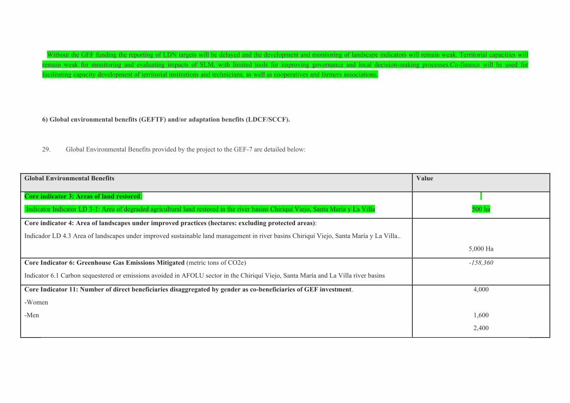
Without the GEF funding the reporting of LDN targets will be delayed and the development and monitoring of landscape indicators will remain weak. Territorial capacities will remain weak for monitoring and evaluating impacts of SLM, with limited tools for improving governance and local decision-making processes.Co-finance will be used for facilitating capacity development of territorial institutions and technicians, as well as cooperatives and farmers associations.
6) Global environmental benefits (GEFTF) and/or adaptation benefits (LDCF/SCCF).
29. Global Environmental Benefits provided by the project to the GEF-7 are detailed below:
Global Environmental Benefits Value
Core indicator 3: Areas of land restored:
Indicator Indicator LD 3-1: Area of degraded agricultural land restored in the river basins Chiriquí Viejo, Santa María y La Villa
500 ha
Core indicator 4: Area of landscapes under improved practices (hectares: excluding protected areas):
Indicador LD 4.3 Area of landscapes under improved sustainable land management in river basins Chiriquí Viejo, Santa María y La Villa..
5,000 Ha
Core Indicator 6: Greenhouse Gas Emissions Mitigated (metric tons of CO2e)
Indicator 6.1 Carbon sequestered or emissions avoided in AFOLU sector in the Chiriquí Viejo, Santa María and La Villa river basins
-158,360
Core Indicator 11: Number of direct beneficiaries disaggregated by gender as co-beneficiaries of GEF investment.
-Women
-Men
4,000
1,600
2,400
7) Innovation, sustainability and scaling potential
30. Innovation: The project is especially innovative in six dimensions: i) development of Panama's ability to report LDN targets and establish the baseline to monitor changes in LDN indicators in the selected river basins, ii) implementation of LDN targets with the upscaling of SLM / CSA / climate smart livestock practices in productive landscapes at the river basin level, iii) strengthening policy coherence with integration of SLM in the national and territorial planning instruments; iv) harmonization of the information management systems for joint decision-making on integrated water and land use planning, v) provision of reliable and timely (agroenvironmental and climate) information services with the use of technological tools (eg. digital technological applications) for broader access to information by technicians and producers and vi) innovative financing mechanisms. The LDN baseline and targets will be dissagregated and monitored at river basin level and integrated into the consolidated National Environmental information system (SINIA). The multisectoral approach will strengthen the governance of the SLM sector in the responsible entities (MiAMBIENTE-MIDA- local governments and local organizations) which will help addressing agricultural productivity, forest restoration and ecosystem services. FAO's assistance will facilitate the use of relevant tools such as LADA, WOCAT, EX ACT, ASIS and others to develop the necessary technical capabilities of MIDA and MiAMBIENTE personnel for combating land degradation, increasing climate resilience and mitigating climate change while supporting the generation of the reports for submission to the international conventions.
31. Sustainability: The project will promote social, environmental and economic sustainability: Socially, it will increase access of a large number of family farmers to extension / information services, empowering them to make decisions about the land use planning and implementation of SLM / CSA practices. The project strengthens the capacities of organizations, including cooperatives and producer associations with the training of their field agents as facilitators (at least 30% women) and youth on SLM / CSA practices and synergies with biodiversity, storage of organic carbon, rational use of water and its importance to improve local livelihoods. Environmentally, the implementation of SLM / CSA practices will contribute to preven land degradation, reduce land degradation and / or restore degraded spaces and rehabilitating ecosystems in the basins and the native biological diversity affected by the degradation processes. Economically, the project will promote the beneficiaries´access to innovative financing mechanisms to adopt/ replicate SLM/CSA practices for key crop production systems and livestock systems as well as it will provide assistance to improve the productive capacity of the land, as well as advice, information and guidance that will help integrate sustainable food value chains, so as to strengthen business capacity in the areas of implementation and consequently increase income of the beneficiaries.
Scaling-up Potential: The strengthening of inter-institutional governance of LDN will facilitate the adoption of a group approach strategy (producers, cooperatives and organizations of private companies, etc.) for the implementation of SLM / CSA practices that generate changes on a large scale through the replication of clear methodologies, policies, instruments and practices. Likewise, linking the progress of this project with the design of the Green Climate Fund initiative to be submitted by the Central American
Bank (CABEI) with a ´source to sea´ approach, and which is being supported by FAO, will allow scaling practices and improvements in governance in other basins and areas of economic interest for Panama.
[1] Plan Estratégico del Gobierno 2020-2024.
[2] La población estimada al 1 de julio de 2018 era de 4,159,000 personas. INEC, 2018.
[3] Índice de pobreza multidimensional de Panama, 2017, Gabinete Social.
[4] La superficie del país es de 75,517 km2.
[5] Diagnóstico del Sector Agropecuario de Panamá, FAO, 2016.
[6] Plan Nacional de Seguridad Hídrica 2015-2050 Agua para Todos.
[7] Tercera Comunicación Nacional de Cambio Climático ante CNUCC. MiAMBIENTE, 2019
[8] Diagnóstico del Sector Agropecuario de Panamá, FAO, 2016.
[9] Country Profile Panama – Investing in LDN : Making the case´ UNCCD Global Mechanism (https://www.unccd.int/sites/default/files/inline-files/Panama_1.pdf)
[10] Atlas Ambiental de Panamá, ANAM, 2010.
[11] Name, Benjamín, Informe de Consultoría Manejo Sostenible de la Tierra, Panamá, fe brero 2020
[12] Soto, Xinia, Informe de consultoría sobre Cambio Climático, Panamá, febrero 2020.
[13] In 2010, the national total of greenhouse gas (GHG) emissions was 7,452.34 Gg of CO2eq, composed of: 8,249.99 Gg (2,804.07 Gg net) of carbon dioxide (CO₂); 172.71 Gg (3,627.39 Gg CO2eq) of methane (CH₄); 3.44 Gg (1,076.11 Gg CO2eq) nitrous oxide (N₂O). Of these emissions, 69% corresponded to the energy sector, 17% to the agriculture, forestry and other land uses (AFOLU) sector; 9% to the waste sector; 5% to the industrial processes sector and product use. Third National Climate Change Communication, 2019.
[14] Third National Climate Change Communication. MiAMBIENTE, 2019.
[15] Third National Climate Change Communication. MiAMBIENTE, 2019.
[16] Agricultural Census, INEC, 2010
[17] Environmental Territorial Planning Plan of the La Villa river basin, CATIE, 2008.
[18] Comprehensive Management Plan for the Upper, Middle and Lower Part of the Santa María River Basin, CATIE, 2009.
[19] Fuentes, Ana Cecilia, Consultancy Report “Reduction and gradual elimination of cop pesticides and highly hazardous pesticides from three important watersheds of Panama”, February, 2020.
[20] Report presented by Mr. Arturo Correa (Implementation of the MTF / GLO / 145 / UEP Project in Latin American countries (Chile, Peru, Argentina, Ecuador, Honduras and Panama), June 2017. Rotterdam Convention. List for prohibited products of Annex III.
[21] Fuentes, Ana Cecilia, Consultancy Report “Reduction and gradual elimination of cop pesticides and highly hazardous pesticides from three important watersheds of Panama”, February, 2020.
[22] Atrazine is used in various crops (sugar cane, corn, pineapple, sorghum, etc.)
[23] Comptroller General of the Republic. Imports 2012-2017.
[24] Mesoamerican Biological Corridor Project of the Panamanian Atlantic (Phase II). ANAM-GEF-BM, Panama.
[25] Fuentes, Ana Cecilia, Consultancy Report “Reduction and gradual elimination of cop pesticides and highly dangerous pesticides from three important watersheds of Panama”, February, 2020.
[26] This report identifies as “poor” those households that have deficiencies in 5 of the 17 indicators that assess the 5 dimensions of well-being; education; housing, basic services and without Internet access; environment, atmosphere and sanitation; Work and health. MIDES, 2017. Report on Multimesional Poverty of Panama, MIDES, 2018.
[27] Law No. 2 of March 20, 1986, Articles 18 and 19 exempts taxes on producers with incomes of up to US $ 100,000.
[28] The System of Sustainable Production and Conservation of Biodiversity / GEF / BM / MiAMBIENTE supported the development of value chains with groups of producers of organic coffee and organic vegetables in the upper parts of the Chiriquí Viejo and Santa María basins that can be replicated in other parts of the selected basins..
[29] http://www.fao.org/land-water/land/ldn/en/
[30] MiAMBIENTE, 2015.
[31] The extensión system is under the responsibility of MIDA with the promotion of agricultural practices at farmer level only.
[32] Ley 69 de 2017 de Incentivos a la Reforestación y Ley 25 de 2005 sobre Transformación Agropecuarias y sus modificiones (2015).
[33] MiAmbiente developed the baseline and submitted it to the UNCCD Global Mechanism but has not yet been validated.
1b. Project Map and Coordinates
Please provide geo-referenced information and map where the project interventions will take place.
Please refer to Annex A
2. StakeholdersSelect the stakeholders that have participated in consultations during the project identification phase:
Indigenous Peoples and Local Communities Yes
Civil Society Organizations Yes
Private Sector Entities Yes
If none of the above,please explain why:
In addition, provide indicative information on how stakeholders, including civil society and indigenous peoples, will be engaged in the project preparation, and their respective roles and means of engagement.
During the preparation of the PIF, national coordination and follow-up meetings were held with officials from MiAMBIENTE, MIDA and FAO. In addition, a stakeholder consultation workshop was held in Santiago de Veraguas, with the participation of 75 people, representing public entities, community groups, women, producer organizations, cooperatives, private companies, banking and research entities of the three selected river basins. The participation of each interest group and its final role in the project will be evaluated / assessed in the PPG phase.
Interest Groups Role in the Project
Ministry of Environment (MiAMBIENTE)
MiAMBIENTE will be the executing agency for the project and the coordinating entity for co-execution with other strategic partners. MiAMBIENTE will also provide technical guidance for the implementation of the project, the monitoring of the results, as well as the submission of project progress reports. MiAMBIENTE will lead the PPG phase of the project on behalf of the Government of Panama.
Ministry of Agricultural Development (MIDA)
MIDA will provide technical support and assistance to producers to implement the strategy of reduction of highly hazardous agrochemicals (HHP), assistance to producer groups for adoption of biopesticides, organic fertilizers and agrochemicals with less impact on the environment and, assistance to promote sustainable production activities at the watershed level.
Ministry of Health
(MINSA)
Coordination with the MINSA will be necessary to assess the health effects of the population in the areas where the project is executed in terms of the reduction in the use of HHP and the reports required by the project.
Financial intermediaries (FIs) During the preparation phase (PPG), consultation will continue with both public banks (eg. BDA and BN) and private banks (eg. Multibank and Global Bank) that have agricultural portfolios in order to engage them in providing financial support to private companies, cooperatives and producer organizations that contribute to the adoption of SLM / CSA, with specific portfolios and preferential rates.
Civil society :
Producer Organizations and Non-Governmental Organizations (NGO)
In the project areas, there is a wide network of producer organizations and NGOS whose past experience gives them an important role as facilitators of training and exchange of experiences, information service providers, as well as promoters of SLM / CSA practices. Among these are:
Chiriquí Viejo River Basin:
Producer organizations: Association of Renaissance producers-APRE, Association of Producers of Exportable Crops-APCE, Organic Group of Cerro Punta-GORACE, Association of Agro-Ecological Producers La Amistad-ASAELA, Association of Producers of Highlands - ACPTA, Association of Rice Producers of Chiriquí-APROACHI, Association of Producers of San Andrés and Baitún, Association of Producers of Beans, Ladies United of Caldera, Union of farmers and peasants of the Renaissance, Rural groups La Doritas de Renacimiento, etc.
Environmental NGOs: Alliance for the Highland Environmental Development (ADATA), the Foundation for the Integral, Community Development and Conservation of the Ecosystems of Panama (FUNDICCEP), the Environmental Association of La Amistad International Park -AMIPILA
La Villa River Basin:
Producer organizations: Association of agroforestry producers of Capuri, Association of bean producers.
NGOs: Fundación pro-eco Azuero (partner of the Alliance for the Million), Association for the promotion of new development alternatives (APRONAD) which has a network of local organizations associated to save the Estibaná river, one of the main tributaries of the river The Ville.
Santa María River Basin:
Producer organizations: Association of organic producers of Santa Fe (APOSF), Association of agroforestry producers La Puente, Association of Producers for Sustainable Development, Association of United Producers of San Roque, Association of Rural Women United for Integral Development ( ASOMUDI), Rural women El Balso. There are also environmental groups: Environmentalist Volunteer Groups, Conservationist Groups, Ecological Groups, Eco-tourism Groups.
NGOs: The Veraguas Productive Development Foundation (FUNDEPROVE).
A more detailed mapping of CBOs and NGOs will be completed during the PPG phase, which will be included in the stakeholder analysis. Their functions in the project will be defined in the Comprehensive plan for stakeholder participation.
Academy
MiAMBIENTE, MIDA and FAO have collaboration agreements with national universities (Universities of Panama -UN, Technological University -UTP, Autonomous University of Chiriquí -UNACHI) on issues of restoration and monitoring of biodiversity; these agreements will remain the basis for future collaborations. During the PPG phase, consultations and participation mechanisms of these universities will be defined. In addition, the Tropical Agricultural Research and Higher Education Center (CATIE) should be evaluated as a potential fund manager given its technical expertise and extensive project management experience.
Public Research and Assistance entities
During the preparation phase (PPG), research organizations such as the Smithsonian Tropical Research Institute (STRI) and the National Secretariat of Science and Technology (SENACYT) are expected to join this initiative in order to share the results of key national research studies in the focal areas of the project. The project will review the participation mechanisms of entities working in the agricultural sector such as the Agricultural Research Institute (IDIAP) on research related to climate resilient seeds and the Institute of Agricultural Insurance (ISA) for lookin at possibilities to foster a new weather based index insurance portfolio that will include early warning mechanisms for extreme weather events such as droughts and natural events that affect crops (winds, floods, etc.).
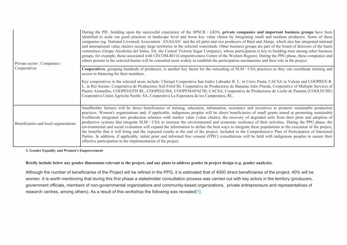
During the PIF, building upon the successful experience of the SPSCB / GEF6, private companies and important business groups have been identified to scale out good practices at landscape level and boost key value chains by integrating small and medium producers. Some of these companies (eg. National Livestock Association ´ANAGAN´ and the oil palm and rice producers of Barú and Alanje, which also has integrated national and international value chains) occupy large territories in the selected watersheds. Other business groups are part of the board of directors of the basin committees (Grupo Alcoholes del Istmo, SA, the Central Victoria Sugar Company), whose participation is key to building trust among other business groups, for example, those associated with CECOM-RO (Competitiveness Center of the Western Region). During the PPG phase, these companies and others present in the selected basins will be consulted more widely to establish the participation mechanisms and their role in the project.
Private sector : Companies / Cooperatives
Cooperatives, grouping hundreds of producers, is another key factor for the outscaling of SLM / CSA practices as they can coordinate training and access to financing for their members.
Key cooperatives in the selected areas include: Chiriquí Cooperativa San Isidro Labrador R. L. in Cerro Punta, CACSA in Volcán and COOPREN R. L. in Río Sereno. Cooperativa de Productores Soil Fértil RL Cooperativa de Productores de Bananas Julio Pineda, Cooperative of Multiple Services of Puerto Armuelles, COOPEGOTH RL, COOPEGUBA, COOPEMAPACHI, CACSA, Cooperativa de Productores de Leche de Panamá (COOLECHE) Cooperativa Unión Agrícola Nestlé, SA, Cooperativa La Esperanza de los Campesinos, RL.
Beneficiaries and local organizations
Smallholder farmers will be direct beneficiaries of training, education, information, assistance and incentives to promote sustainable production practices. Women's organizations and, if applicable, indigenous peoples will be direct beneficiaries of small grants aimed at promoting sustainable livelihoods integrated into production schemes with market value (value chains), the recovery of degraded soils from their plots and adoption of productive systems that integrate SLM / CSA to increase the environmental and economic resilience of their activities. During the PPG phase, the environmental and social evaluation will expand the information to define the best ways to integrate these populations in the execution of the project, the benefits that it will bring and the expected results at the end of the project, included in the Comprehensive Plan of Participation of Interested Parties. In addition, if applicable, initial prior and informed free consent (FPIC) consultations will be held with indigenous peoples to ensure their effective participation in the implementation of the project.
3. Gender Equality and Women's Empowerment
Briefly include below any gender dimensions relevant to the project, and any plans to address gender in project design (e.g. gender analysis).
Although the number of beneficiaries of the Project will be refined in the PPG, it is estimated that of 4000 direct beneficiaries of the project, 40% will be women. It is worth mentioning that during this first phase a stakeholder consultation process was carried out with key actors in the territory (producers, government officials, members of non-governmental organizations and community-based organizations, private entrepreneurs and representatives of research centres, among others). As a result of this workshop the following was revealed[1]:

a) There are several organizations that integrate actions to promote gender equality and the youth approach as part of their work in the territory, including the Rural Development and Agriculture Directorate (MIDA), MiAmbiente (Production Systems Project Sustainable and Biodiversity Conservation), MINSA, Agricultural Development Bank (BDA), Ministry of Social Development (MIDES), Fundación Natura, among others.b) There are specific women's organizations associated with agricultural activities, marketing, handicrafts, ecotourism and agritourism, etc. Attendees of the logical framework workshop mention that there are about 50 women's organizations in the selected basins, some mentioned in Point 2 as Stakeholders. It will be required in the PPG to identify them. Likewise, participants expressed that there is a high percentage of women participating in sub-basin committees and in mixed community-based associations with which they work. It is also perceived that women are organized around issues of health, education, training, household income and environmental conservation.c) It is perceived that the young population is mostly organized in mixed associations linked to school, productive and environmental conservation issues.d) Women and young people have less access to land tenure and credit, compared to men.e) Among the main sources of income in women, agriculture stands out (livestock, coffee production and collection, fruit production, handicrafts, among others). On the other hand, by asking them how they spend the income they receive, they say that women spend more on their families and care activities, while men distribute their income on their families and leisure activities.f) Regarding the management and use of agrochemicals, due to the roles that men and women play, they consider that it is men who are most exposed to risks.g) As to indigenous and Afro-descendant peoples in the territory, it was mentioned that the Gnabe Bugle people may only be present in the Santa Maria basin; in the other basins, it has been reported that the indigenous and Afro-descendant peoples do not live in the area, however they work in the territory (this information will be specified in the PPG).
To contribute to achieve gender equality and women empowerment in the project, a gender expert will be hired during the PPG phase to carry out a social analysis, a gender assessment and a gender action plan with the necessary budget.
As part of the assessment methodology, the gender expert will analyze the gender roles, livelihoods, socio-economic conditions of women and their access to natural resources, financial instruments, market, knowledge and technical innovations. Based on this analysis, gender sensitive actions and indicators will be included in the project design. Gender and disaggregation by sex will be reflected in the project results framework as well as actions that
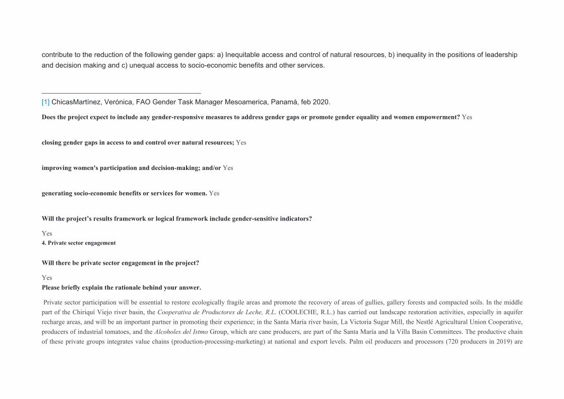
contribute to the reduction of the following gender gaps: a) Inequitable access and control of natural resources, b) inequality in the positions of leadership and decision making and c) unequal access to socio-economic benefits and other services.
[1] ChicasMartínez, Verónica, FAO Gender Task Manager Mesoamerica, Panamá, feb 2020.
Does the project expect to include any gender-responsive measures to address gender gaps or promote gender equality and women empowerment? Yes
closing gender gaps in access to and control over natural resources; Yes
improving women's participation and decision-making; and/or Yes
generating socio-economic benefits or services for women. Yes
Will the project’s results framework or logical framework include gender-sensitive indicators?
Yes 4. Private sector engagement
Will there be private sector engagement in the project?
Yes Please briefly explain the rationale behind your answer.
Private sector participation will be essential to restore ecologically fragile areas and promote the recovery of areas of gullies, gallery forests and compacted soils. In the middle part of the Chiriquí Viejo river basin, the Cooperativa de Productores de Leche, R.L. (COOLECHE, R.L.) has carried out landscape restoration activities, especially in aquifer recharge areas, and will be an important partner in promoting their experience; in the Santa María river basin, La Victoria Sugar Mill, the Nestlé Agricultural Union Cooperative, producers of industrial tomatoes, and the Alcoholes del Istmo Group, which are cane producers, are part of the Santa María and la Villa Basin Committees. The productive chain of these private groups integrates value chains (production-processing-marketing) at national and export levels. Palm oil producers and processors (720 producers in 2019) are

located in the lower part of the Chiriquí Viejo river basin and must adopt good agricultural practices and product traceability to remain in the international market, for which the Panama Footprint certification will open new national and international markets.
Another relevant group in all the basins is the National Association of Cattle Ranchers (ANAGAN), which is part of the La Villa River Basin Committee, they have partners in all the basins, which makes them a key associate to replicate sustainable pasture management and climate smart livestock practices in the productive landscape; ANAGAN has approached MiAMBIENTE requesting its inclusion in the best livestock practices programs due to the effects that climate change is having on farms. They were consulted in the PIF stage and the consultations will be extended during the PPG phase to design active participation strategies to engage these companies and their associates to invest in sustainable production techniques and implement restoration actions for their farms. This action is linked to the “Panama Footprint” certification of MiAMBIENTE, which will be implemented by 2021, as an incentive to make efficiente use of water and reduce CO2 emissions generated by livestock activity and the production of key commodities (sugarcane, palm, tomato, coffee, rice, etc.) improve / strengthen the access of these economic groups to more environmentally demanding national and international markets. During the implementation of the project, agreements of different types will be promoted and alliances with financing intermediaries will be encouraged to improve access to public bank financing (BDA, BN). In addition, a Stakeholder Participation Plan will be developed in which the mechanisms to involve the private sector will be defined, as well as their role as project co-financiers.5. Risks to Achieving Project Objectives
Indicate risks, including climate change, potential social and environmental risks that might prevent the Project objectives from being achieved, and, if possible, propose measures that address these risks to be further developed during the Project design (table format acceptable)
As per the FAO Environmental & Social safeguards, this proposal has been screened and classified as Moderate risk. This project will be installing and improving small-scale water storage systems over three river basins, will be providing planting material and utilize biopesticides in agricultural production systems. Therefore, a full environmental, social and climate risk analysis will be conducted during PPG phase.
Possible additional identified risks are detailed in the following table:
Probability Potential Risk Foreseen Mitigation Measures
Low
Environmental
Climate variability and climate change reduce the effectiveness of SLM practices implemented by the project
CSA and Climate Smart Livestock approach will be adopted within basins in order to increase resilience to climate variability and climate change.
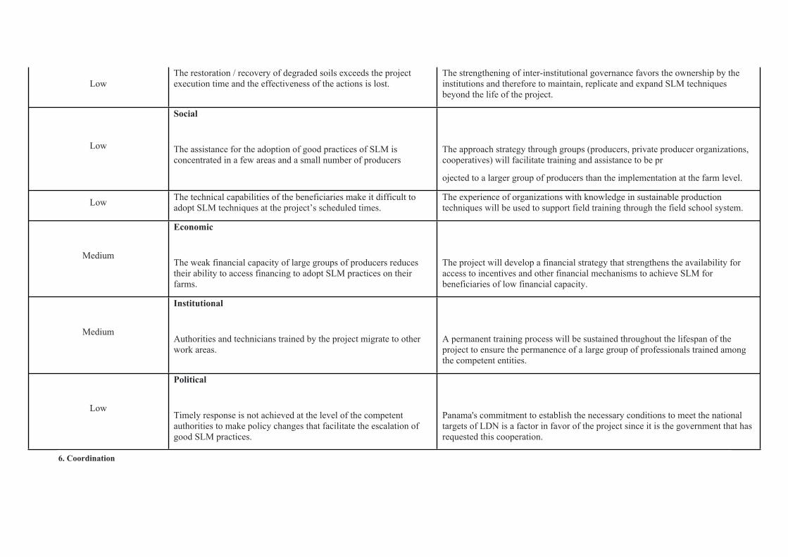
LowThe restoration / recovery of degraded soils exceeds the project execution time and the effectiveness of the actions is lost.
The strengthening of inter-institutional governance favors the ownership by the institutions and therefore to maintain, replicate and expand SLM techniques beyond the life of the project.
Low
Social
The assistance for the adoption of good practices of SLM is concentrated in a few areas and a small number of producers
The approach strategy through groups (producers, private producer organizations, cooperatives) will facilitate training and assistance to be pr
ojected to a larger group of producers than the implementation at the farm level.
Low The technical capabilities of the beneficiaries make it difficult to adopt SLM techniques at the project’s scheduled times.
The experience of organizations with knowledge in sustainable production techniques will be used to support field training through the field school system.
Medium
Economic
The weak financial capacity of large groups of producers reduces their ability to access financing to adopt SLM practices on their farms.
The project will develop a financial strategy that strengthens the availability for access to incentives and other financial mechanisms to achieve SLM for beneficiaries of low financial capacity.
Medium
Institutional
Authorities and technicians trained by the project migrate to other work areas.
A permanent training process will be sustained throughout the lifespan of the project to ensure the permanence of a large group of professionals trained among the competent entities.
Low
Political
Timely response is not achieved at the level of the competent authorities to make policy changes that facilitate the escalation of good SLM practices.
Panama's commitment to establish the necessary conditions to meet the national targets of LDN is a factor in favor of the project since it is the government that has requested this cooperation.
6. Coordination
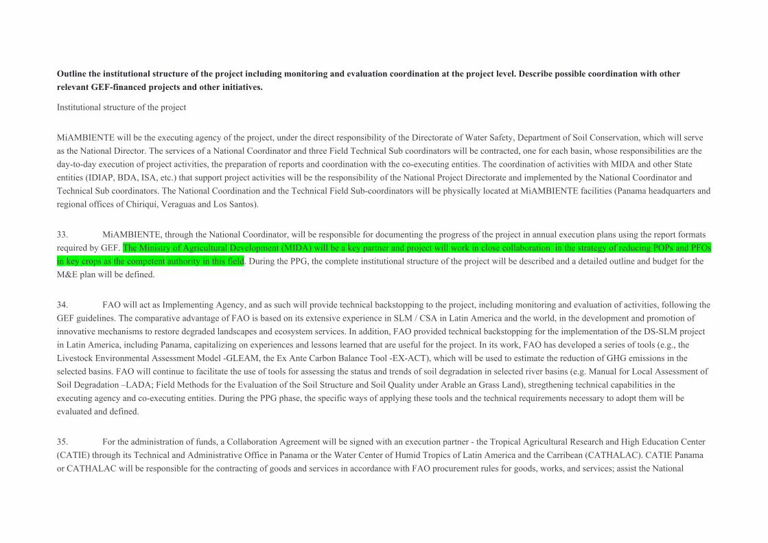
Outline the institutional structure of the project including monitoring and evaluation coordination at the project level. Describe possible coordination with other relevant GEF-financed projects and other initiatives.
Institutional structure of the project
MiAMBIENTE will be the executing agency of the project, under the direct responsibility of the Directorate of Water Safety, Department of Soil Conservation, which will serve as the National Director. The services of a National Coordinator and three Field Technical Sub coordinators will be contracted, one for each basin, whose responsibilities are the day-to-day execution of project activities, the preparation of reports and coordination with the co-executing entities. The coordination of activities with MIDA and other State entities (IDIAP, BDA, ISA, etc.) that support project activities will be the responsibility of the National Project Directorate and implemented by the National Coordinator and Technical Sub coordinators. The National Coordination and the Technical Field Sub-coordinators will be physically located at MiAMBIENTE facilities (Panama headquarters and regional offices of Chiriquí, Veraguas and Los Santos).
33. MiAMBIENTE, through the National Coordinator, will be responsible for documenting the progress of the project in annual execution plans using the report formats required by GEF. The Ministry of Agricultural Development (MIDA) will be a key partner and project will work in close collaboration in the strategy of reducing POPs and PFOs in key crops as the competent authority in this field. During the PPG, the complete institutional structure of the project will be described and a detailed outline and budget for the M&E plan will be defined.
34. FAO will act as Implementing Agency, and as such will provide technical backstopping to the project, including monitoring and evaluation of activities, following the GEF guidelines. The comparative advantage of FAO is based on its extensive experience in SLM / CSA in Latin America and the world, in the development and promotion of innovative mechanisms to restore degraded landscapes and ecosystem services. In addition, FAO provided technical backstopping for the implementation of the DS-SLM project in Latin America, including Panama, capitalizing on experiences and lessons learned that are useful for the project. In its work, FAO has developed a series of tools (e.g., the Livestock Environmental Assessment Model -GLEAM, the Ex Ante Carbon Balance Tool -EX-ACT), which will be used to estimate the reduction of GHG emissions in the selected basins. FAO will continue to facilitate the use of tools for assessing the status and trends of soil degradation in selected river basins (e.g. Manual for Local Assessment of Soil Degradation –LADA; Field Methods for the Evaluation of the Soil Structure and Soil Quality under Arable an Grass Land), stregthening technical capabilities in the executing agency and co-executing entities. During the PPG phase, the specific ways of applying these tools and the technical requirements necessary to adopt them will be evaluated and defined.
35. For the administration of funds, a Collaboration Agreement will be signed with an execution partner - the Tropical Agricultural Research and High Education Center (CATIE) through its Technical and Administrative Office in Panama or the Water Center of Humid Tropics of Latin America and the Carribean (CATHALAC). CATIE Panama or CATHALAC will be responsible for the contracting of goods and services in accordance with FAO procurement rules for goods, works, and services; assist the National

Directorate in the preparation of invitation for bids and / or terms of reference for hiring, monitoring, selection, formalization of contracts and payments, with prior authorization from the National Directorate; issue periodic financial reports and be part of the audits required during the execution of the project. MiAMBIENTE is considering CATIE to provide support for this task, based on the successful past experience of this research centre in the administration of funds for other MiAMBIENTE projects and CATIE's extensive field expertise on the technical areas of the project.
36. The roles, commitments and responsibilities of each of the instances of project implementation will be defined in detail during the PPG phase.
Coordination with relevant GEF-financed project and other initiatives
37. Evaluation of the DS-SLM project in Latin America, including Panama, highlights key results and provides valuable lessons learned on key issues for mainstreaming and outscaling SLM and land restoration practices in land use systems. Other experiences and lessons learned will come from NGOs working on territorial planning and Sustainable Land Management within the selected river basins (ANCON, CATHALAC, CATIE, NATURA, etc.). Likewise, key information will be exchanged on topics that will be developed by this project (SLM, CC, Agrochemicals and DB), through the process of publication and stakeholder participation, including indigenous peoples and women's groups.
38. “Sustainable Production Systems and Biodiversity Conservation Project” (GEFID 5546 / 2014-2019) - Its experiences and lessons learned on the implementation of sustainable production systems, biodiversity conservation, effective protection of protected areas and ecosystem connectivity, the strengthening of value chains with organizations and producer groups in the selected basins, particularly in Chiriquí Viejo and Santa María, will be taken as a reference. The best practices and lessons learned will be considered when working with producer groups / organizations, establishing agreements between buyers and farmers and the marketing of sustainable products (monocultures and livestock) that generate GHG in production landscapes, and provide technical assistance and training to producers. The project will also make use of the lessons learned and best practices resulting from the implementation of the GEF Small Grants Program (GSP) in Panama. These will include experiences in biodiversity conservation on livestock farms, diversification of production, habitat conservation of biodiversity and restoration of degraded lands, among other related topics.
¨Conservation and Sustainable Use of Biodiversity in Coastal Marine Production Landscapes¨ (GEFID 9804, UNDP as IA) - Despite the fact that there is no thematic or geographic coincidence between the two projects, efforts will be made during PPG stage to share information about the impacts of best SLM practices on aquatic biodiversity in coastal marine areas and, more specifically, in relation with marine spatial planning (ZEMMC). ¨Ecosystem-based Biodiversity Friendly Cattle Production Framework for the Darien Region of Panama¨ (GEFID 9589) - Best practices and knowledge on sustainable pasture management will be shared between both projects.7. Consistency with National Priorities
Is the Project consistent with the National Strategies and plans or reports and assesments under relevant conventions
Yes If yes, which ones and how: NAPAs, NAPs, ASGM NAPs, MIAs, NBSAPs, NCs, TNAs, NCSAs, NIPs, PRSPs, NPFE, BURs, INDCs, etc
The project is aligned with the national strategies and consistent with international commitments of Panama under the different Convention such as:- the United Nation Convention to Combat Desertification (UNCCD): As reported previously in the baseline of the proposed project and associated projects under UNCCD, the project will support the implementation of the LDN Strategy for Panama and contribute to achieve and monitor the five national LDN Targets:
• Target 1: At 2030 forest cover has been incremented by 26%.
• Target 2: By 2025: Reduce the conversion of 18,000 ha of forests into fallow land and shrubs and / or agricultural soils.
• Target 3: By 2030: Increase the productivity of 62,000 hectares of agricultural land and 12,000 hectares of scrubland and grassland with decreasing productivity and early deterioration.
• Target 4: By 2020: Improve coordination between different institutions, civil society, unions and promote participatory mechanisms.
• Target 5: By 2020: Improve the existing legal framework so that it would strengthen the LDN program.
- United Nations Framework Convention on Climate Change (UNFCCC) and National Communication (NC): Panamá is currently preparing its 4NCCC. This exercise will include information generated by this project through the consolidated National Environmental Information System (SINIA). Project will support the efforts taken by the government to develop “Huella Panamá¨. Information about reduction of CO2eq will be reported in project evaluations as well as considered into National Inventory of GHG system.
- United Nations Convention on Biological Diversity (UNCBD):Project will contribute to diminish preasures over protected areas located in the three targeted basins
- Stockholm Agreement.: Project will contribute to include COPs and PFOs reductions in environmental policies, such as ¨Huella Panamá¨, strategies to diminish HHPs and POPs and uses in key crops and identify organic alternatives to replace them (biopesticides and organic fertilizers).
- Rotterdam Agreement:Project will improve the information of small and médium producers about risks and best practices of HHPs and POPs as well as management of waste related.
8. Knowledge Management
Outline the Knowledge management approach for the Project, including, if any, plans for the Project to learn from other relevant Projects and initiatives, to assess and document in a user-friendly form, and share these experiences and expertise with relevant stakeholders.
Knowledge management activities are included in component 4, but they are also part of components 2 and 3 with training / assistance / advice for the adoption of best practices. These activities will include the systematization of the knowledge generated and the exchange of experiences and lessons learned with other producer associations to promote the scaling up of these sustainable practices. Knowledge products / publications will be developed. The results of the project will be shared inside and outside the areas of intervention through existing information networks and forums for inter-information, the Panama reports in the International Conferences (UNCDB, UNFCCC, UNCCD), the Agreements on agrochemicals signed by Panama and the national portals of MiAMBIENTE, MIDA and collaborating partners of the project. The project may participate in FAO-GEF-sponsored networks of similar projects in other Latin American countries in particular and worldwide in general, on findings, reports, successful experiences, etc. that can strengthen the knowledge of technicians and beneficiaries, as well as collaborators and associates. A continuous task will be the identification and report of lessons learned, as well as the dissemination to the beneficiaries of findings, recommendations and best practices to apply in their plots.
9. Environmental and Social Safeguard (ESS) Risks
Provide information on the identified environmental and social risks and potential impacts associated with the project/program based on your organization's ESS systems and procedures
Overall Project/Program Risk Classification*
PIF CEO Endorsement/Approval MTR TE
Medium/ModerateMeasures to address identified risks and impacts
Provide preliminary information on the types and levels of risk classifications/ratings of any identified environmental and social risks and potential impacts associated with the project (considering the GEF ESS Minimum Standards) and describe measures to address these risks during the project design.
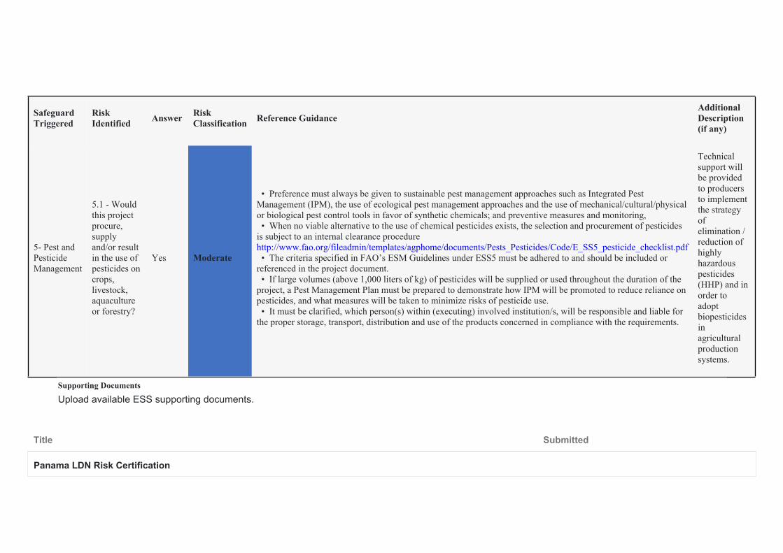
Safeguard Triggered
Risk Identified Answer Risk
Classification Reference GuidanceAdditional Description (if any)
5- Pest and Pesticide Management
5.1 - Would this project procure, supply and/or result in the use of pesticides on crops, livestock, aquaculture or forestry?
Yes Moderate
• Preference must always be given to sustainable pest management approaches such as Integrated Pest Management (IPM), the use of ecological pest management approaches and the use of mechanical/cultural/physical or biological pest control tools in favor of synthetic chemicals; and preventive measures and monitoring, • When no viable alternative to the use of chemical pesticides exists, the selection and procurement of pesticides is subject to an internal clearance procedure http://www.fao.org/fileadmin/templates/agphome/documents/Pests_Pesticides/Code/E_SS5_pesticide_checklist.pdf • The criteria specified in FAO’s ESM Guidelines under ESS5 must be adhered to and should be included or referenced in the project document. • If large volumes (above 1,000 liters of kg) of pesticides will be supplied or used throughout the duration of the project, a Pest Management Plan must be prepared to demonstrate how IPM will be promoted to reduce reliance on pesticides, and what measures will be taken to minimize risks of pesticide use. • It must be clarified, which person(s) within (executing) involved institution/s, will be responsible and liable for the proper storage, transport, distribution and use of the products concerned in compliance with the requirements.
Technical support will be provided to producers to implement the strategy of elimination / reduction of highly hazardous pesticides (HHP) and in order to adopt biopesticides in agricultural production systems.
Supporting Documents
Upload available ESS supporting documents.
Title Submitted
Panama LDN Risk Certification
Part III: Approval/Endorsement By GEF Operational Focal Point(S) And Gef Agency(ies)
A. RECORD OF ENDORSEMENT OF GEF OPERATIONAL FOCAL POINT (S) ON BEHALF OF THE GOVERNMENT(S): (Please attach the Operational Focal Point endorsement letter with this template).
Name Position Ministry Date
Gustavo Padilla Head of International Cooperation Ministry of Environment of Panama 3/23/2020
ANNEX A: Project Map and Geographic Coordinates
Please provide geo-referenced information and map where the project intervention takes place
Project Map and Coordinates
Project Execution Areas
The project execution areas were selected from 6 priority basins proposed by MiAMBIENTE. The selection was made throughout a participatory process based on:
· Technical criteria: soil degradation maps, agrological capacity, current use, hydrology, geographic and administrative coverage;
· Social criteria: existence of basin committees, management plans or other planning instruments, producer organizations that already had some knowledge of SLM techniques, organic production or environmentally friendly production;
· Economic criteria: production systems, economic importance of the basin at local and national level, multidimensional poverty index;
· Environmental criteria: areas of environmental/biological interest, protected areas, biodiversity conservation.
The financial capacity of the project to decide the scope of territorial coverage and efficient use of resources, such as jurisdiction, access, size of the basin and the relationship with logistics and administrative costs to develop the activities was a constraint.
The three selected basins (Chiriquí Viejo, Santa María and La Villa) cover an area of 594,970 ha and are inhabited by 304,968 people). In them, totally or partially protected areas of global interest are located, such as the Amistad International Park and Volcan Barú National Park, which are part of the La Amistad Biosphere Reserve in the Chiriquí Viejo river basin; and the Santa Fe National Park in the Santa María river basin. They also host several areas of biodiversity of national importance (El Montuoso Forest Reserve, Lagunas de Volcán, La Yeguada Forest Reserve, Ciénaga de Las Macanas, Cenegón del Mangle) (See Table 1). These protected areas retain a rich biodiversity represented by birds, mammals, reptiles and amphibians; a very high diversity of angiosperms and endemic vascular plants of restricted distribution; In addition to a wide variety of freshwater species. The geographical configuration of these basins ranges from the upper parts with a predominance of mature and intervened forests to the lower parts with the existence of
wetlands, mangroves, marshes and estuaries; The adoption of SLM / CSA techniques at the level of the productive landscape will have positive impacts on terrestrial, aquatic and marine ecosystems.
Economically, these are areas of productive importance for the local market (rice, corn, vegetables, milk, beef and pork, beans) and export (sugar, sugarcane-based liquors, coffee, melon, watermelon ). However, socially, 15% of the population lives in multidimensional poverty, excluded from economic wealth, usually dependent on subsistence agriculture on degraded land. The management plan of the Santa María river basin reveals that 25% of the land occupied in agricultural use is for subsistence, with little or no technical assistance nor access to the market. (See Table No.2).
The specific characteristics of each basin are:
Basin 102 Chiriquí Viejo River: It covers an area of 133,940 hectares that includes the Renacimiento and Highlands districts, and partially the districts of Bugaba and Alanje in which 17 counties are located (see map of the Chiriquí Viejo River Basin 1) with a population of 88,619 inhabitants (2010). It extends from the central mountain range (Pacific slope) to mangroves in the Bay of Charco Azul in the Gulf of Chiriquí in the Pacific. It comprises diverse ecosystems (mountains, wetlands, an extensive water network, mangroves, grasslands and cultivation areas, as well as protected areas) located in microclimate areas, with an average temperature of 17.8°C in the upper part, favored by heights that can reach up to 900 meters above sea level, humid to very humid climate, to areas of medium and low elevation occupied with productive systems, in which the temperature can reach up to 35.5°C[1].
The upper and middle areas comprise a mountainous system of steep slopes due to tectonism ranging from 15 to 30 ° (occupying 23.5% of the total area of the basin) and over 30 ° in 7% of the territory. Forested areas (23.1% of its territory) are located in the upper part and in some areas in the middle part in patches of forests. The upper area of the basin is part of the La Amistad International Park and the Volcan Barú National Park [2] (see Table 2) where primary and secondary forests are located. 22.2% of the soils in the basin are arable (class II, III and IV), 34% are not arable with little to moderate risk of erosion (V and VI) and the remaining 43.8% must be used for conservation or protection (See Table 2). In the high part it has deep soils but with a high tendency to erosion due to the broken terrain. It is estimated that the laminar erosion of the soil[3] in its middle and upper middle zones is between 20 to 100 t / ha / year with an average loss of 40 t / ha / year in 32.3% of its territory. The part most affected by degradation is located in the middle part[4].
In areas used for production (53.8% of the territory), minimum erosion ranges were estimated at <20 t / ha / year (56%) in the high zone, average ranges of 20 to 40 (11.7%) and 40 to 60 t / ha / year (10.1%) in the medium-low zone and maximum ranges 60 - 100 (17.5%) and> 100 t / ha / year (4.7%) in the middle and middle-high part. A resulting effect is the sedimentation on the banks of the rivers (on the east side of the city of Volcán an area of sediments of 8.9 km2 was delimited) and in the mouth (mangrove) deposits of
sediments were observed up to 1 m deep ; Slight contamination of water bodies. Livestock use in areas that do not have capacity for this activity produces soil compaction, erosion, formation of gullies and loss of infiltration, with the consequent loss of productive capacity. The areas of Breñón, Caizán, Cerrón and Santa Clara present this problem.
The basin comprises a profuse water network with the Chiriquí Viejo River as its main source, which extends for 161 kms from the central mountain range to the Pacific Ocean, and numerous rivers, including the Colorado, Gariché, Baiton, Caña Blanca rivers, Caizán, Jacú, Caño Gorge, North and Santa Clara. The average flow of the basin is 33.72 m3 / sec, varying between 60.11 m3 / sec in October the rainiest to 14.51 m3 / sec in March the driest month (CATHALAC, 2016)[5], favored by a high annual average rainfall of 3,470 mm being the rainiest May-December[6] period and runoff, evapotranspiration and infiltration processes relatively stable during the dry or rainy season. Reports from CATHALC (2016) indicate the existence of 300 current concessions for electric power generation (the greatest demand), human, industrial / agroindustry, recreational / tourist and agricultural consumption (the lowest demand). The average annual supply and demand at the basin level is positive, of the 10 contribution areas, in the area of the birth of the Chiriquí Viejo River (# 2) and in the Candela area (# 4) in the months of February, March and April there is a water deficit, and in the Caizán river area (# 6) from December to April. The highest consumption occurs in the northeastern part of the basin where hydroelectric plants that demand up to 90% of the supply in non-consumptive[7] use are concentrated.
The water quality of the Chiriquí Viejo river basin using physical-chemical parameters (MiAMBIENTE 2016) in 7 sampling points of the upper, middle and lower parts, showed good water quality in 5 of the seven sampling points (value of the ICA above 70) with the best water quality in the upper parts (within La Amistad IP and Volcan Barú NP; however, at two points (Los Gonzales near the Volcán Barú NP and The Final Gate in the middle part) the water was slightly contaminated. However, when evaluating the biological quality of the water[8] at 10 sampling points, the analysis of hydro morphological parameters showed that, except for the points within the PILA and Volcan Barú, the water ranges from slightly contaminated to highly contaminated (Los González and the final gate)[9].
Among the main environmental problems is the elimination of vegetation cover for agricultural activities, mainly in the upper part, exposing the slopes causing landslide and loss of soil, and consequently the dragging of a large amount of sediments that go to the courses of water in the rainy season. Another problem documented by MIDA is the presence of 40 pesticides in water courses and in the sediment in the upper part, which presented values higher than the limits allowed by international regulations, hence the biological quality of these tributaries has resulted in water medium to high pollution[10]. Alternatives promoted by MiAMBIENTE (SPSCB) in the upper part of the basin are promoting the adoption of organic agriculture in vegetables and coffee (GORACE-AMIPILA, APRE). That should continue to support. This is an economically very important region. It is the supplier of 90% of the vegetables consumed in the country, the first producer of dairy products and the second producer of export coffee. It is also an important producer of rice, beef cattle, beans and strawberries.
The main climatic risks are the increase of rains in the middle part with increases of +10 raising the risk to floods[11] and the potential saline intrusion due to the growth of the tides in the low zone[12].
Basin 128 La Villa River. It comprises an area of 128,430 ha in 6 districts of Herrera and Los Santos and 38 counties. It is inhabited by 98,332 people (2010), of which 16% (15,235) are multidimensional poor (See Table 1 and map of the La Villa river basin). It is located in the Dry Arc region, a climatic region of very low rainfall and tropical dry forest, considered highly vulnerable to climate change[13], whose characteristics of temperature, solar radiation and precipitation and the development of tropical plants, whose requirements are very hot and humidity, classify it as an area of mega thermal vegetation. The temperature can vary from 23 ° C to 33 ° C with an average of 31 ° C most of the year. The average annual rainfall is 1,752 mm, however in its high part it can reach up to 2155 mm (Quebrada de Piedra), and although the rainy season is from May to December,[14] almost a third of the annual precipitation occurs in the month of October . The average altitude is only 135 meters above sea level, but in the upper part of the El Montuoso Forest Reserve it reaches 839 meters above sea level with better weather and rainfall conditions, favorable for crops such as beans (variety of beans) that demand a cooler climate. In 65% of its territory the soils are shallow with a flat relief for the most part. 27.5% of the soils are arable with classes from II to IV, 8.5% have restrictions for agricultural use and 64% of the soils are recommended for forest or conservation use; Even so, 39.5% are occupied with crops and pastures and 43.5% with fallow land and thickets, which means that productive activity occurs in soils not suitable for these activities (See Table 2). Only in its high part in the El Montuoso Forest Reserve are some primary and secondary forests left that are only 12.3% of the territory. In its territory there are dry climate ecosystems (low and medium part) and rainier climate (high part) that give way to forests, grasslands, crops, wetlands, protected areas of local importance, mangroves and marshes (see Table 2).
Its water network is smaller than those of the other basins, the La Villa river being its main river that extends for 150 km (this river is born in RF El Montuoso and flows into Parita Bay). Important secondary rivers are Estibaná Gato, Quebrada Pesé, Quebrada de Piedra, Tebarito River and others. The water supply is highly variable, starting from 0.1 m3 / sec (Quebrada Grande) to 75 m3 / sec (La Villa river). The lack of forest cover plays an important role in water retention, detention and infiltration, generating a very high runoff, with the consequent discharge of the basin, limiting the possibilities of a regulation of winter flows, being the availability of water Its main limitation. The highest value shortage index[15] is recorded in the lower part of the basin in the dry season, however, even in the rainy season (May-December) in the Quebrada Pesé and Quebrada Grande sub-basins the shortage index can be up to 100% There is no policy on the protection of water recharge areas, nor the efficient management of water use[16], aggravating the situation of water resources.
In 2016 MiAMBIENTE analyzed the water quality with physical-chemical parameters in 7 sampling points of the basin, and with except 2, the water quality was good (ICA between 70 and 81); In that 2 points is slightly contaminated. The biological quality of the water in the basin was also evaluated in terms of the biological[17] quality at 14 points, excellent water was found in the upper part of the river La Villa within the RF El Montuoso, 7 points with good quality, 3 highly contaminated and 2 with regular quality.
The agricultural pressure in the middle and lower part, with intensive agricultural activities without conservation techniques, conditions an expansive migration process due to the loss of soil fertility, lack of protection and exposure to climatic events[18]. The main environmental problem is that 82.7% of the basin has been deforested, giving way to pastures and crops on land without productive capacity. The pressure of anthropic activities is mainly recorded in the middle and lower part of the basin and corresponds to agriculture,
including subsistence, livestock, pig farming, urban and industrial growth. Problems of land use include: overgrazing, the elimination of vegetation cover along riverbanks and streams, leaving them unstable and highly vulnerable to erosion at discharge time, large tracts of land arranged for corn and cane cultivation, practice of "slash and burn", excessive use of agrochemicals, mishandling of water intake sites as well as solid waste and sewage sites, sedimentation in the channel, and eutrophication. On the other hand, some of the water intakes are located in the middle and lower part of the basin where the largest part of the population and economic activities are concentrated and therefore are recipients of all activities that are carried out upstream, which increases the cost of water treatment so that it is suitable for human consumption.[19]
Basin 132 Santa Maria River. The Santa María river basin covers an area of 333,600 hectares that extends from the mountainous part of the central mountain range in Veraguas to the coastal area of Parita Bay in the Dry Arc region. It comprises 12 districts of 4 provinces (Herrera, Los Santos, Veraguas and Coclé) with 59 counties and a population of 118,017 people, of which 17% (20,158) people are dimensional poor (See Table 1 and map of the river basin Santa Maria). Protected areas found in this basin are the Santa Fé National Park, the La Yeguada Forest Reserve, the Los Pozos de Calobre Natural Monument, the Ciénegas de Las Macanas, the Cenegón del Mangle Wildlife Reserve and the Sarigua National Park (See Table 2).
The average elevation of the basin to the mouth is 200 meters above sea level and the highest point is in the Cordillera Central, with a maximum elevation of 1528 meters above sea level, followed by the hills, Negro, Cabeza de Toro, Narices, Piragua and La Gaita (ECOAMBIENTE SA, 1997). In its upper part, depicts shallow soils prone to laminar erosion (it is estimated that 22.9% is susceptible to erosion and 66.85% at medium risk),[20] in its middle and lower parts, it extends into lands of small hills and plains in which the risk of erosion is lower; However, although it is estimated that the loss of soils is less than 12.5 t / ha / year in the middle and lower parts, 35.9% of the soils are arable and with high capacity for agricultural work (class II to IV soils); 8.6% have mild to severe limitations for agricultural use (soils V and VI) and 56.5% is class VII and VIII, that is, for forest use or conservation lands. Nonetheless, in this basin 67.6% of the area is occupied with agricultural and livestock activities; of that total, 24.4% corresponds to subsistence agriculture (See Table 2). An important part of the productive activity is developed in soils with no capacity for agricultural work. A large part is produced without productive techniques or soil conservation, which deteriorates the water table and promotes a migratory process towards unoccupied lands that have better productive conditions. In the high and medium high it is estimated that the loss of soils is greater than 12.5 t / ha / year.[21]
The average rainfall is 2,308.42 mm (1972-2008 period) with a dry season that extends from December to April. The average temperature is 25.3 ° C. The water supply is supplied by a profuse network of rivers, streams, etc. The most important river is Santa María, which extends 168 km towards the San Francisco, Gatú, Cañazas, Escotá, Estero Salado and others rivers. The flows measured between 1980-2015 of the different rivers range from 0.70 m3 / sec (Estero Salado) to 265 m3 / sec (Santa María). The basin in general does not show a lack of water availability at any time of the year although in the dry season (January-March) it decreases to about 70%. An important factor is that in the Santa María River sub-basin the scarcity index can be 100% in its lower part, not because of lack of water but because the demand exceeds the supply of this sub-basin and in September and October the shortage index It can be from 67 to 79%[22].
Water quality analysis of this basin using physical chemical parameters (MiAMBIENTE, 2016) revealed water contamination at the three sampling points (ICA between 59 and 66) in the Gatú, Batú and Santa María rivers. However, when evaluating the biological[23] quality of the water, the sampling point Primer Brazo, located in the Santa Fe National Park, showed the highest values, which translates into an optimal biological environment, as well as other sampling points of the upper basin. On the other hand, the sampling points in the middle and lower parts recorded values ranging from light to severely polluted waters, especially in the areas most occupied by crops and homes. The points located in the lower part revealed the highest levels of pollution (Cañazas and mouth of the Santa María River). This is due to the proximity of extensive crop farms (cane) and pastures.
Environmental problems arise from the pressures of anthropic activities mainly in the middle and lower part of the basin. The extension of land arranged for cane and rice crops, livestock, urban and industrial growth, among others, occupy land with no capacity for agricultural use. The deterioration of water quality is due to the reception of organic discharges, mineral and inorganic substances, pesticides, fungicides; herbicides and sediments (PRODESO-CATIE, 2006). Another problem is caused by the extraction of sand and stone directly from the main tributaries. On the other hand, a hydroelectric plant is operating in this basin, seven other concessions have been granted and five are currently in process (ASEP, 2017) which would mean a very strong competition for the water resource.
The greatest threat of climate change is the forecast of the reduction in rainfall that could be up to -25% according to the modeling of the 2015-20150 Water for All National Water Safety Plan.
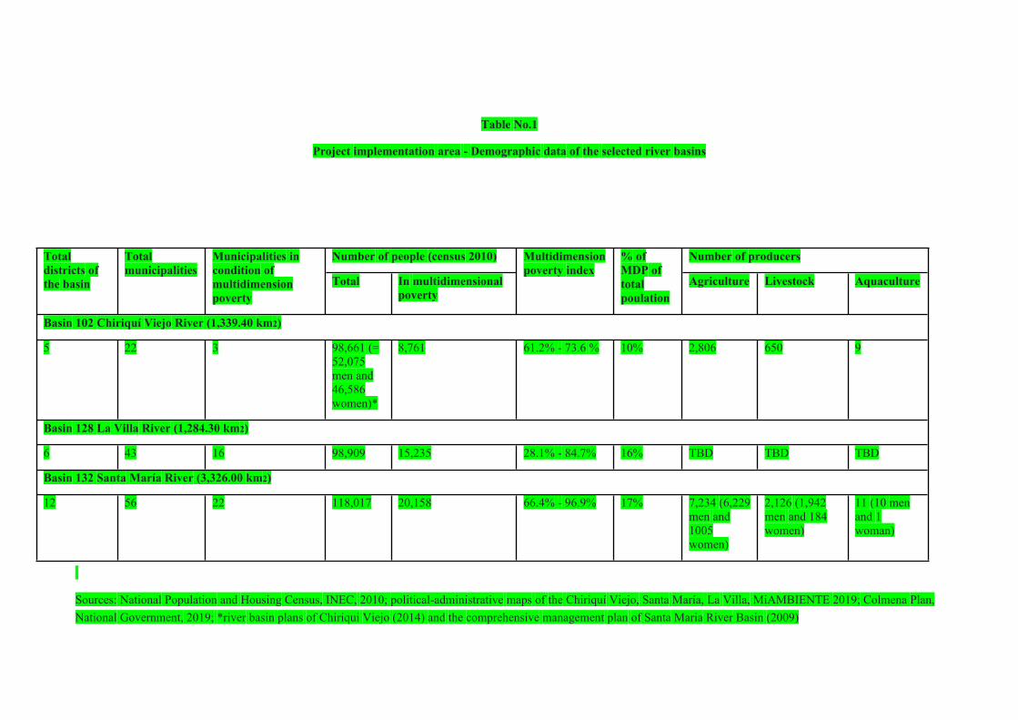
Table No.1
Project implementation area - Demographic data of the selected river basins
Number of people (census 2010) Number of producers Total districts of the basin
Total municipalities
Municipalities in condition of multidimension poverty
Total In multidimensional poverty
Multidimension poverty index
% of MDP of total poulation
Agriculture Livestock Aquaculture
Basin 102 Chiriquí Viejo River (1,339.40 km2)
5 22 3 98,661 (= 52,075 men and 46,586 women)*
8,761 61.2% - 73.6 % 10% 2,806 650 9
Basin 128 La Villa River (1,284.30 km2)
6 43 16 98,909 15,235 28.1% - 84.7% 16% TBD TBD TBD
Basin 132 Santa María River (3,326.00 km2)
12 56 22 118,017 20,158 66.4% - 96.9% 17% 7,234 (6,229 men and 1005 women)
2,126 (1,942 men and 184 women)
11 (10 men and 1 woman)
Sources: National Population and Housing Census, INEC, 2010; political-administrative maps of the Chiriquí Viejo, Santa María, La Villa, MiAMBIENTE 2019; Colmena Plan, National Government, 2019; *river basin plans of Chiriqui Viejo (2014) and the comprehensive management plan of Santa Maria River Basin (2009)
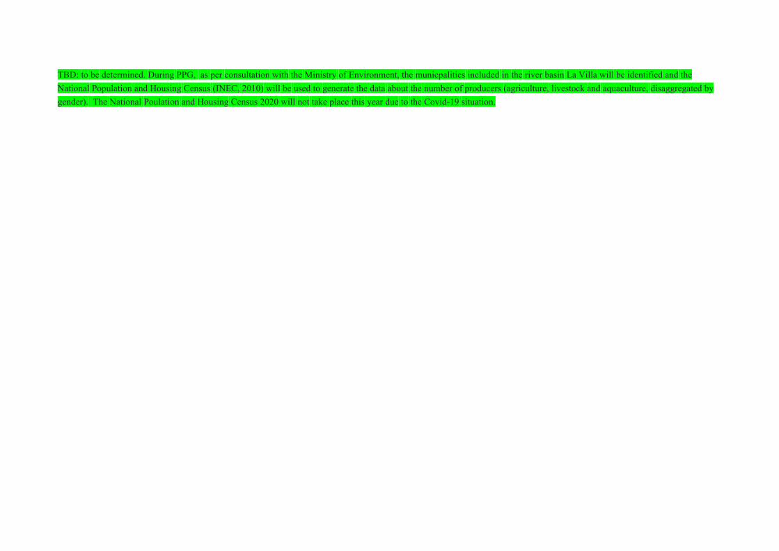
TBD: to be determined. During PPG, as per consultation with the Ministry of Environment, the municpalities included in the river basin La Villa will be identified and the National Population and Housing Census (INEC, 2010) will be used to generate the data about the number of producers (agriculture, livestock and aquaculture, disaggregated by gender). The National Poulation and Housing Census 2020 will not take place this year due to the Covid-19 situation.
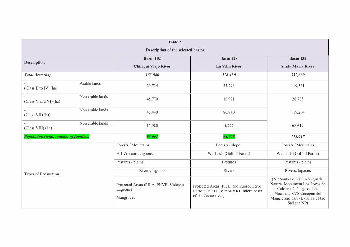
Table 2.
Description of the selected basins
DescriptionBasin 102
Chiriquí Viejo River
Basin 128
La Villa River
Basin 132
Santa María River
Total Area (ha) 133,940 128,430 332,600
- Arable lands (Class II to IV) (ha) 29,734 35,296 119,531
- Non arable lands (Class V and VI) (ha) 45,770 10,921 28,785
- Non arable lands (Class VII) (ha) 40,440 80,940 119,284
- Non arable lands (Class VIII) (ha) 17,980 1,227 68,619
Population (total, number of families) 98,661 98,909 118,017
Forests / Mountains Forests / slopes Forests / Mountains
HII Volcano Lagoons Wetlands (Golf of Parita) Wetlands (Golf of Parita)
Pastures / plains Pastures Pastures / plains
Rivers, lagoons Rivers Rivers, lagoonsTypes of Ecosystems
Protected Areas (PILA, PNVB, Volcano Lagoons)
Mangroves
Protected Areas (FR El Montuoso, Cerro Barrola, BP El Colmón y RH micro basin of the Cacao river)
(NP Santa Fe, RF La Yeguada, Natural Monument Los Pozos de
Calobre, Ciénaga de Las Macanas, RVS Cenegón del
Mangle and part -1,730 ha of the Sarigua NP)
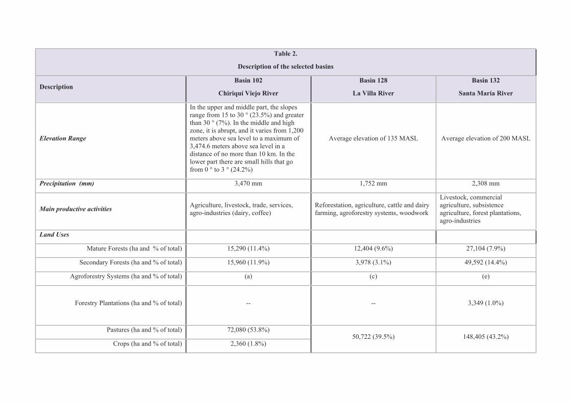
Table 2.
Description of the selected basins
DescriptionBasin 102
Chiriquí Viejo River
Basin 128
La Villa River
Basin 132
Santa María River
Elevation Range
In the upper and middle part, the slopes range from 15 to 30 ° (23.5%) and greater than 30 ° (7%). In the middle and high zone, it is abrupt, and it varies from 1,200 meters above sea level to a maximum of 3,474.6 meters above sea level in a distance of no more than 10 km. In the lower part there are small hills that go from 0 ° to 3 ° (24.2%)
Average elevation of 135 MASL Average elevation of 200 MASL
Precipitation (mm) 3,470 mm 1,752 mm 2,308 mm
Main productive activities Agriculture, livestock, trade, services, agro-industries (dairy, coffee)
Reforestation, agriculture, cattle and dairy farming, agroforestry systems, woodwork
Livestock, commercial agriculture, subsistence agriculture, forest plantations, agro-industries
Land Uses
Mature Forests (ha and % of total) 15,290 (11.4%) 12,404 (9.6%) 27,104 (7.9%)
Secondary Forests (ha and % of total) 15,960 (11.9%) 3,978 (3.1%) 49,592 (14.4%)
Agroforestry Systems (ha and % of total) (a) (c) (e)
Forestry Plantations (ha and % of total) -- --
3,349 (1.0%)
Pastures (ha and % of total) 72,080 (53.8%)
Crops (ha and % of total) 2,360 (1.8%)50,722 (39.5%) 148,405 (43.2%)
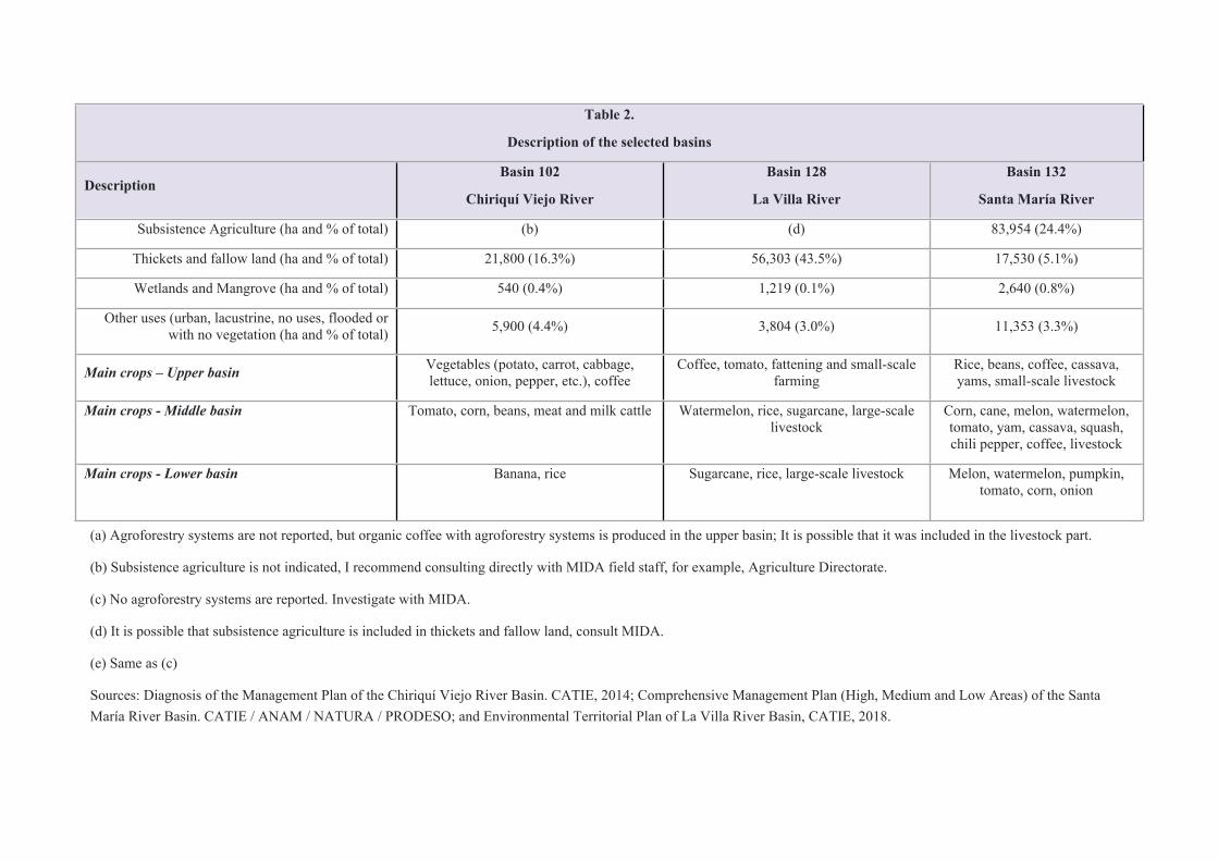
Table 2.
Description of the selected basins
DescriptionBasin 102
Chiriquí Viejo River
Basin 128
La Villa River
Basin 132
Santa María River
Subsistence Agriculture (ha and % of total) (b) (d) 83,954 (24.4%)
Thickets and fallow land (ha and % of total) 21,800 (16.3%) 56,303 (43.5%) 17,530 (5.1%)
Wetlands and Mangrove (ha and % of total) 540 (0.4%) 1,219 (0.1%) 2,640 (0.8%)
Other uses (urban, lacustrine, no uses, flooded or with no vegetation (ha and % of total) 5,900 (4.4%) 3,804 (3.0%) 11,353 (3.3%)
Main crops – Upper basin Vegetables (potato, carrot, cabbage, lettuce, onion, pepper, etc.), coffee
Coffee, tomato, fattening and small-scale farming
Rice, beans, coffee, cassava, yams, small-scale livestock
Main crops - Middle basin
Tomato, corn, beans, meat and milk cattle Watermelon, rice, sugarcane, large-scale livestock
Corn, cane, melon, watermelon, tomato, yam, cassava, squash, chili pepper, coffee, livestock
Main crops - Lower basin
Banana, rice Sugarcane, rice, large-scale livestock Melon, watermelon, pumpkin, tomato, corn, onion
(a) Agroforestry systems are not reported, but organic coffee with agroforestry systems is produced in the upper basin; It is possible that it was included in the livestock part.
(b) Subsistence agriculture is not indicated, I recommend consulting directly with MIDA field staff, for example, Agriculture Directorate.
(c) No agroforestry systems are reported. Investigate with MIDA.
(d) It is possible that subsistence agriculture is included in thickets and fallow land, consult MIDA.
(e) Same as (c)
Sources: Diagnosis of the Management Plan of the Chiriquí Viejo River Basin. CATIE, 2014; Comprehensive Management Plan (High, Medium and Low Areas) of the Santa María River Basin. CATIE / ANAM / NATURA / PRODESO; and Environmental Territorial Plan of La Villa River Basin, CATIE, 2018.
[1] Diagnosis of the Management Plan of the Chiriquí Viejo River Basin. CATIE, 2014.
[2] Diagnosis of the Management Plan of the Chiriquí Viejo River Basin. CATIE, 2014.
[3] Review of the Universal Soil Loss Equation (RUSLE). Diagnosis of the Management Plan of the Chiriquí Viejo River Basin. CATIE, 2014.
[4] Environmental and socioeconomic diagnosis study of the Chiriquí Viejo river basin (102) / Management Plan for the Chiriquí Viejo river basin, CATIE, 2014.
[5] Evaluation of the water availability (supply and demand) of the river basins of the Chiriquí (108), Chiriquí Viejo (102) and Chico (106) rivers, CATHALAC-MiAMBIENTE, 2016..
[6] Diagnosis of the Management Plan of the Chiriquí Viejo River Basin. CATIE, 2014.
[7] The base tool used for hydrological modeling is SWAT (Soil and Water Assessment Tool), which allowed to determine the water supply by contribution area in sub-basins and obtain the water balance for each sub-basin contribution area of the rivers evaluated. Evaluation of the water availability (supply and demand) of the river basins of the Chiriquí (108), Chiriquí Viejo (102) and Chico (106) rivers, CATHALAC-MiAMBIENTE, 2016.
[8] The Biological Monitoring Working Party (BMWP) tool that analyzes the presence of macroinvertebrates indicators of the biological quality of water was used..
[9] Diagnosis of the environmental condition of the surface tributaries of Panama. MiAMBIENTE-SENACYT-GORGAS, 2006..
[10] Diagnosis of the environmental condition of the surface tributaries of Panama. MiAMBIENTE-SENACYT-GORGAS, 2006..
[11]Water Security Plan 2015-2050 Water for All..
[12] Diagnosis of the Management Plan of the Chiriquí Viejo River Basin. CATIE, 2014.
[13] Environmental ATLAS of Panama. ANAM, 2010.
[14] https://es.weatherspark.com/y/18360/Clima-promedio-en-Las-Tablas-Panamá-durante-todo-el-año
[15] A high shortage index does not mean that the sub-basin is in a critical condition (without water availability), but is an alert to identify in which areas of the basin area more than 40% of the availability of the water resource is being used.
[16] Current status of water availability in the river basins of the La Villa (128), Santa María (132) and Grande (134) rivers. CATHALAC-MiAMBIENTE, 2018.
[17] Biological Monitoring Working Party (BMWP).
[18] Environmental Territorial Planning of the La Villa river basin. CATIE-ANAM-PRONAT, 2008.
[19] Current status of water availability in the river basins of La Villa rivers (128), Santa María (132) and Grande (134). CATHALAC-MiAMBIENTE, 2018.
[20] Comprehensive Management Plan (Upper, Middle and Lower) of the Santa María River Basin. CATIE/ANAM/NATURA/ PRODESO.
[21] Comprehensive Management Plan of the Upper, Middle and Lower Part of the Santa María River Basin.CATIE-ANAM-PRODESO-NATURA, 2009.
[22] Current status of water availability in the river basins of La Villa rivers (128), Santa María (132) and Grande (134). CATHALAC-MiAMBIENTE, 2018.
[23] Biological Monitoring Working Party (BMWP).