Embed Size (px)
Citation preview
(ii) (i)
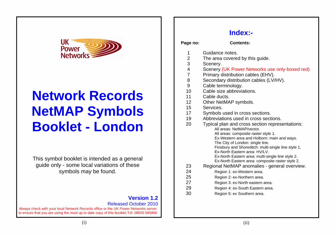
Index:- Page no: Contents:
1 Guidance notes. 2 The area covered by this guide. 3 Scenery. 4 Scenery (UK Power Networks use only-boxed red) 7 Primary distribution cables (EHV). 8 Secondary distribution cables (LV/HV). 9 Cable terminology. 10 Cable size abbreviations. 11 Cable ducts. 12 Other NetMAP symbols. 15 Services. 17 Symbols used in cross sections. 19 Abbreviations used in cross sections. 20 Typical plan and cross section representations: All areas: NetMAP/vector. All areas: composite raster style 1.
Ex-Western area and Holborn: main and ways. The City of London: single line.
Finsbury and Shoreditch: multi-single line style 1. Ex-North Eastern area: HV/LV.
Ex-North Eastern area: multi-single line style 2. Ex-North Eastern area: composite raster style 2.
23 Regional NetMAP anomalies - general overview. 24 Region 1: ex-Western area. 25 Region 2: ex-Northern area. 27 Region 3: ex-North eastern area. 29 Region 4: ex-South Eastern area. 30 Region 5: ex Southern area.
Network Records NetMAP Symbols Booklet - London
This symbol booklet is intended as a general guide only - some local variations of these
symbols may be found.
Version 1.2 Released October 2010
Always check with your local Network Records office or the UK Power Networks server to ensure that you are using the most up to date copy of this booklet.Tel: 08000 565866
c Crown Copyright
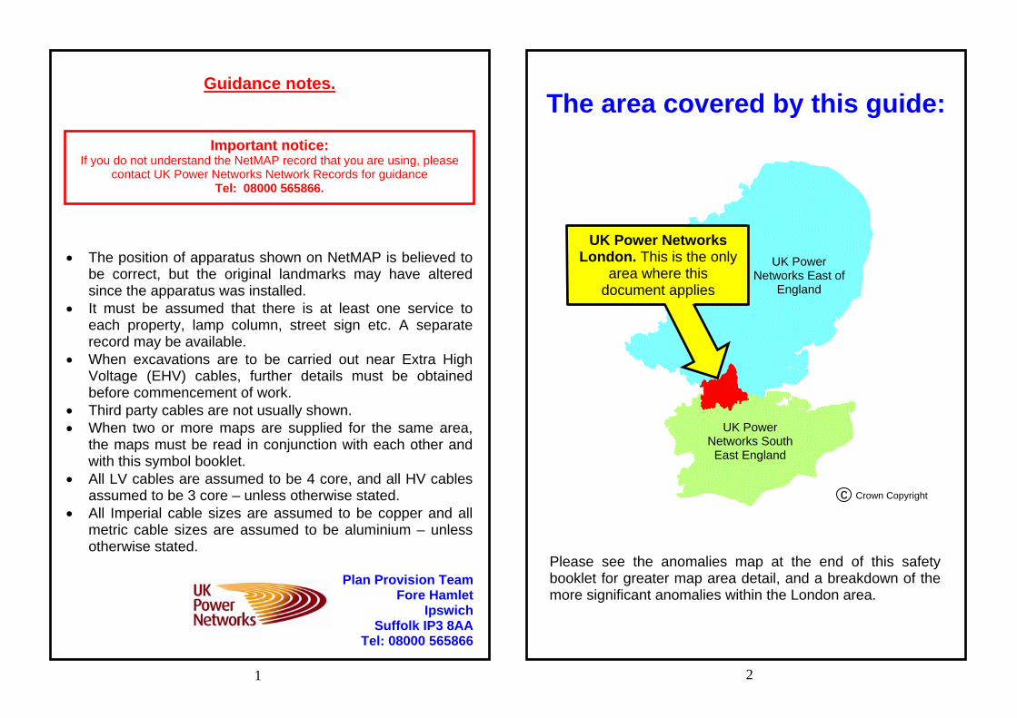
Guidance notes.
The position of apparatus shown on NetMAP is believed to
be correct, but the original landmarks may have altered since the apparatus was installed.
It must be assumed that there is at least one service to each property, lamp column, street sign etc. A separate record may be available.
When excavations are to be carried out near Extra High Voltage (EHV) cables, further details must be obtained before commencement of work.
Third party cables are not usually shown. When two or more maps are supplied for the same area,
the maps must be read in conjunction with each other and with this symbol booklet.
All LV cables are assumed to be 4 core, and all HV cables assumed to be 3 core – unless otherwise stated.
All Imperial cable sizes are assumed to be copper and all metric cable sizes are assumed to be aluminium – unless otherwise stated.
1 2
Plan Provision Team Fore Hamlet
Ipswich Suffolk IP3 8AA
Tel: 08000 565866
UK Power Networks London. This is the only
area where this document applies
UK Power Networks South
East England
UK Power Networks East of
England
Please see the anomalies map at the end of this safety booklet for greater map area detail, and a breakdown of the more significant anomalies within the London area.
The area covered by this guide: Important notice:
If you do not understand the NetMAP record that you are using, please contact UK Power Networks Network Records for guidance
Tel: 08000 565866.
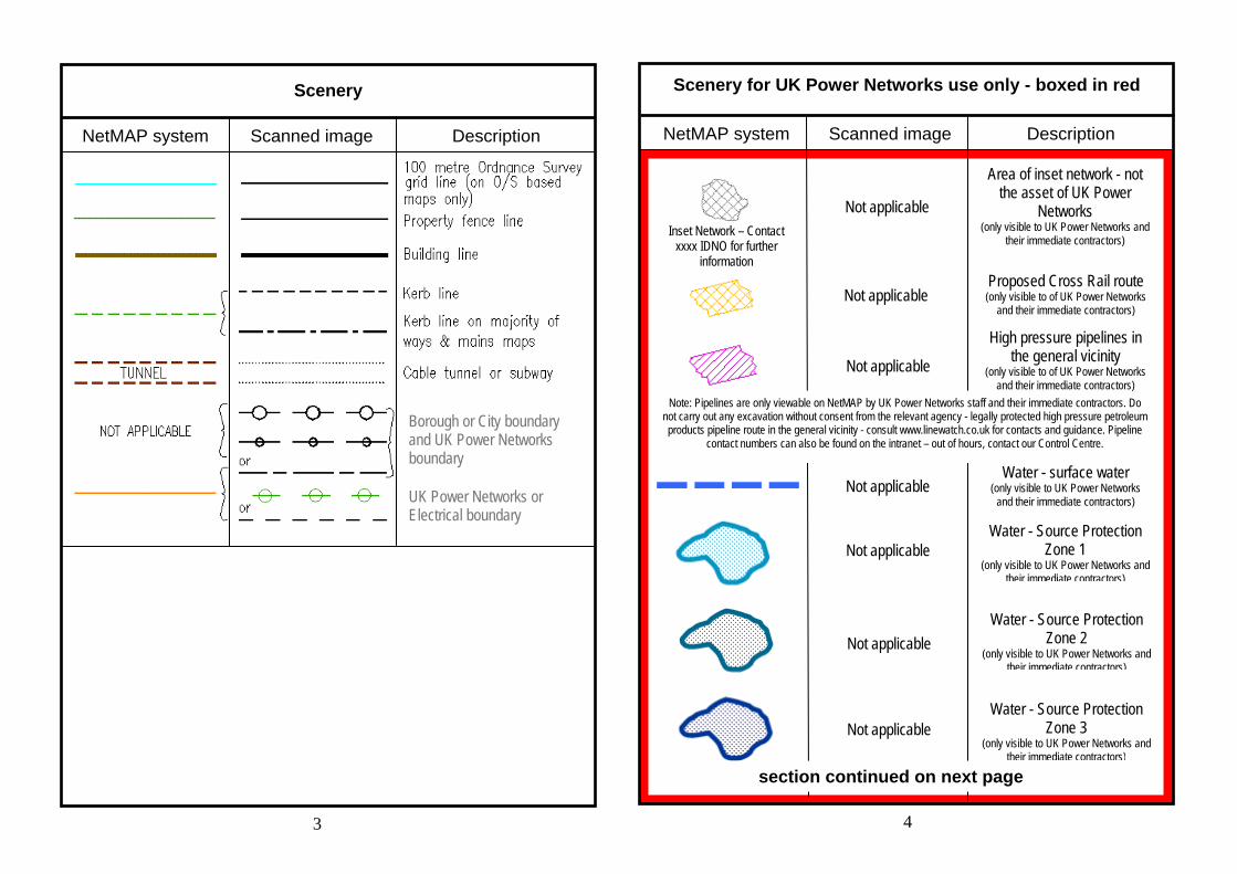
Scenery for UK Power Networks use only - boxed in red Scenery
NetMAP system Scanned image Description NetMAP system Scanned image Description
3 4
Note: Pipelines are only viewable on NetMAP by UK Power Networks staff and their immediate contractors. Do not carry out any excavation without consent from the relevant agency - legally protected high pressure petroleum products pipeline route in the general vicinity - consult www.linewatch.co.uk for contacts and guidance. Pipeline
contact numbers can also be found on the intranet – out of hours, contact our Control Centre.
Inset Network – Contact xxxx IDNO for further
information
Not applicable
Not applicable
Not applicable
Not applicable
Not applicable
Not applicable
Not applicable
Area of inset network - not the asset of UK Power
Networks (only visible to UK Power Networks and
their immediate contractors)
Proposed Cross Rail route (only visible to of UK Power Networks
and their immediate contractors)
High pressure pipelines in the general vicinity
(only visible to of UK Power Networks and their immediate contractors)
Water - surface water (only visible to UK Power Networks
and their immediate contractors)
Water - Source Protection Zone 1
(only visible to UK Power Networks and their immediate contractors)
Water - Source Protection Zone 2
(only visible to UK Power Networks and their immediate contractors)
Water - Source Protection Zone 3
(only visible to UK Power Networks and their immediate contractors)
section continued on next page
Borough or City boundary and UK Power Networks boundary
UK Power Networks or Electrical boundary
Scenery for UK Power Networks use only - boxed in red
NetMAP system Scanned image Description
Scenery for UK Power Networks use only - boxed in red NetMAP system Scanned image Description
5 6
Historical - Areas of Archaeological Potential (AAP)
(only visible to UK Power Networks and their Immediate contractors)
Historical - Parks and Gardens
(only visible to UK Power Networks and their immediate contractors)
Historical - Scheduled Monuments
(only visible to UK Power Networks and their immediate contractors)
Not applicable
Not applicable
Not applicable
Not applicable
Not applicable
Not applicable
Not applicable
Not applicable
Not applicable
Not applicable
Not applicable
Not applicable
Not applicable
Not applicable
Not applicable
Nature - Ramsar Wetlands of International Importance (only visible to UK Power Networks
and their immediate contractors)
Nature - Special Area of Conservation (SAC)
(only visible to UK Power Networks and their immediate contractors)
Nature - Special Protected Area (SPA)
(only visible UK Power Networks and their immediate contractors)
Nature - Local Nature Reserve
(only visible to UK Power Networks and their immediate contractors)
Nature - National Nature Reserve
(only visible to UK Power Networks and their immediate contractors)
Nature - Area of Outstanding Natural Beauty (AONB)
(only visible to UK Power Networks and their immediate contractors)
Nature - National Park (only visible to UK Power Networks
and their immediate contractors)
Fluid filled cables - very high sensitivity
(only visible to UK Power Networks and their immediate contractors) Fluid filled cables - high
sensitivity (only visible to UK Power Networks
and their immediate contractors) Fluid filled cables - medium
sensitivity (only visible to UK Power Networks
and their immediate contractors) Fluid filled cables - low
sensitivity (only visible to UK Power Networks
and their immediate contractors) section continued on next page
Nature - Site of Special and Scientific Interest (SSSI)
(only visible to UK Power Networks and their immediate contractors)
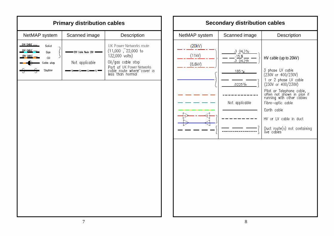
Primary distribution cables Secondary distribution cables
NetMAP system Scanned image Description NetMAP system Scanned image
7 8
Description
HV cable (up to 20kV)
UK Power Networks
UK Power Networks route
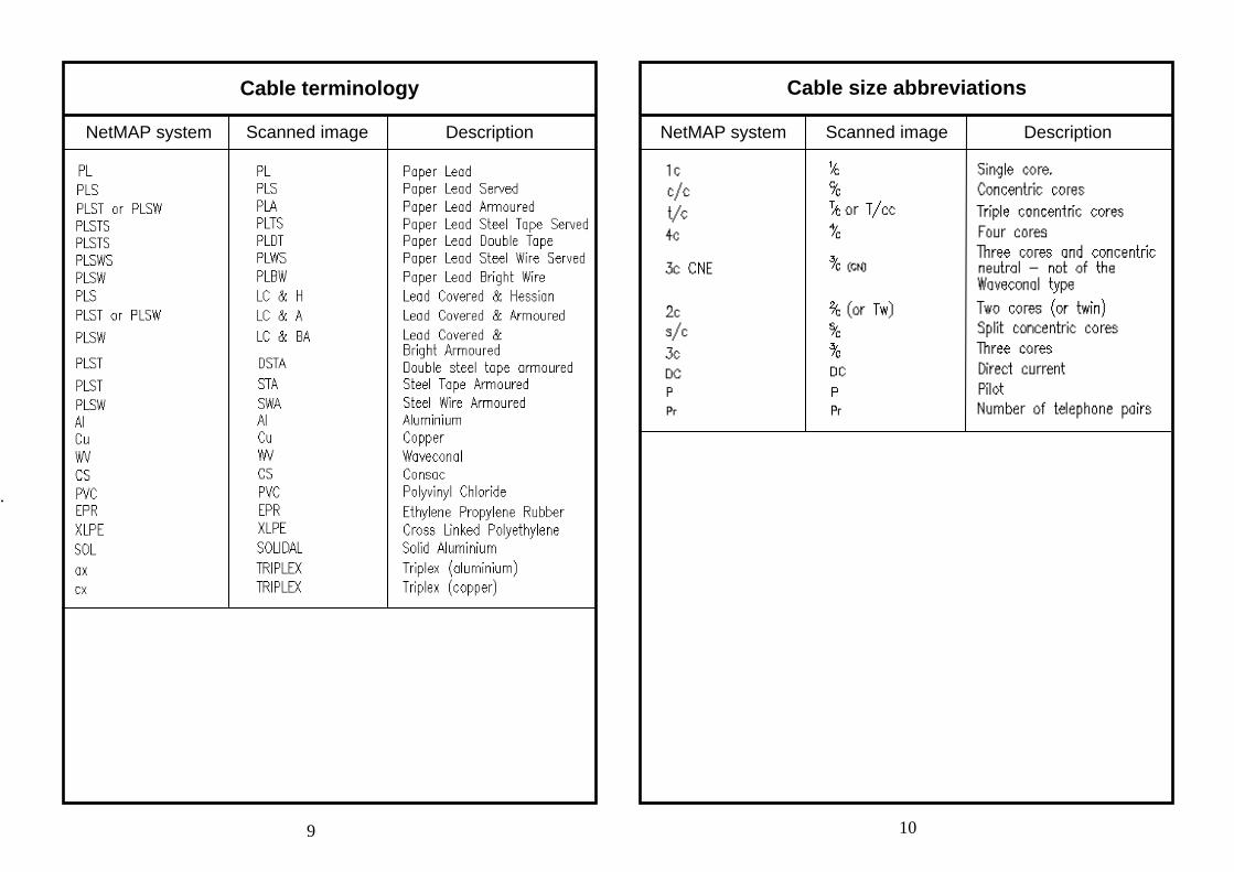
Cable terminology Cable size abbreviations
NetMAP system Scanned image Description NetMAP system Scanned image Description
9 10
.
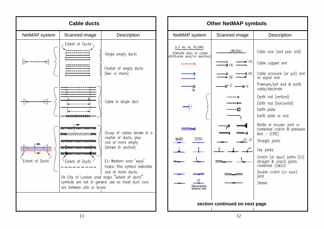
Cable ducts Other NetMAP symbols
NetMAP system Scanned image Description NetMAP system Scanned image Description
11 12
section continued on next page
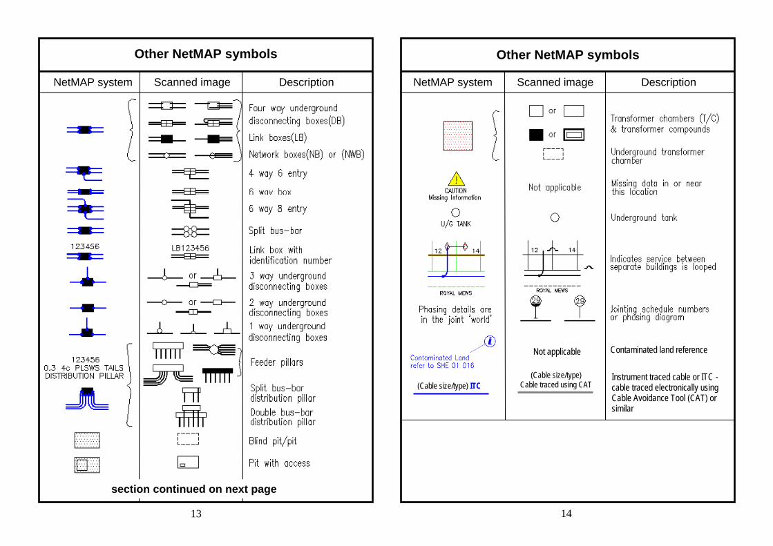
Other NetMAP symbols Other NetMAP symbols
NetMAP system Scanned image Description NetMAP system Scanned image Description
13 14
Not applicable Contaminated land reference
Instrument traced cable or ITC - cable traced electronically using Cable Avoidance Tool (CAT) or similar
(Cable size/type) ITC (Cable size/type)
Cable traced using CAT
section continued on next page
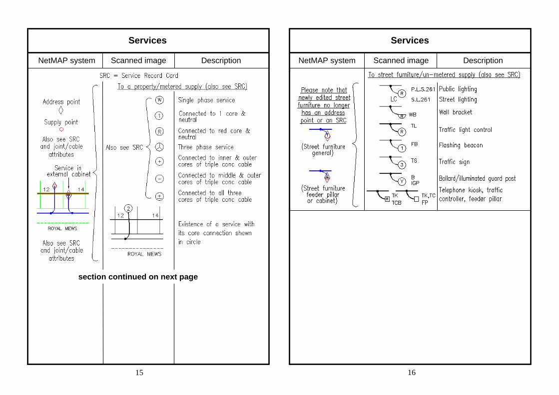
Services
NetMAP system Scanned image Description NetMAP system Scanned image Description
15 16
Services
section continued on next page
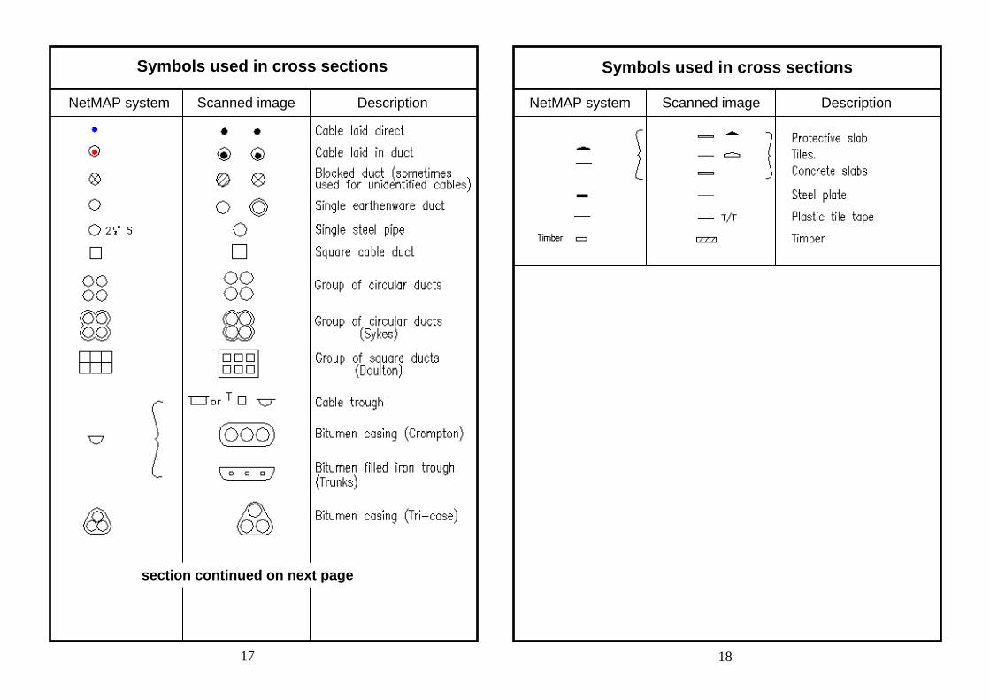
Symbols used in cross sections
NetMAP system Scanned image Description NetMAP system Scanned image Description
17 18
Symbols used in cross sections
section continued on next page
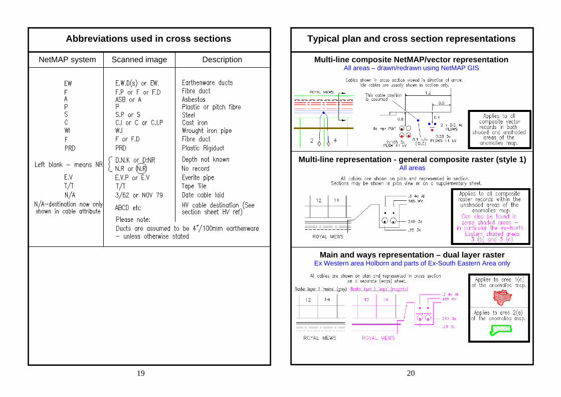
Abbreviations used in cross sections
NetMAP system Scanned image Description
19 20
Typical plan and cross section representations
Multi-line composite NetMAP/vector representation All areas – drawn/redrawn using NetMAP GIS
Multi-line representation - general composite raster (style 1) All areas
Main and ways representation – dual layer raster Ex Western area Holborn and parts of Ex-South Eastern Area only
21 22
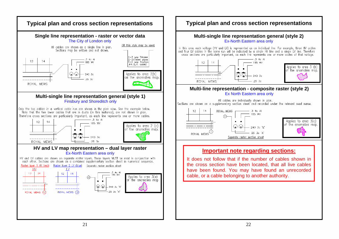
Typical plan and cross section representations Typical plan and cross section representations
Multi-single line representation general (style 1) Finsbury and Shoreditch only
Multi-single line representation general (style 2) Ex-North Eastern area only
Single line representation - raster or vector data The City of London only
HV and LV map representation – dual layer raster Ex-North Eastern area only
Multi-line representation - composite raster (style 2) Ex North Eastern area only
Important note regarding sections: It does not follow that if the number of cables shown in the cross section have been located, that all live cables have been found. You may have found an unrecorded cable, or a cable belonging to another authority.
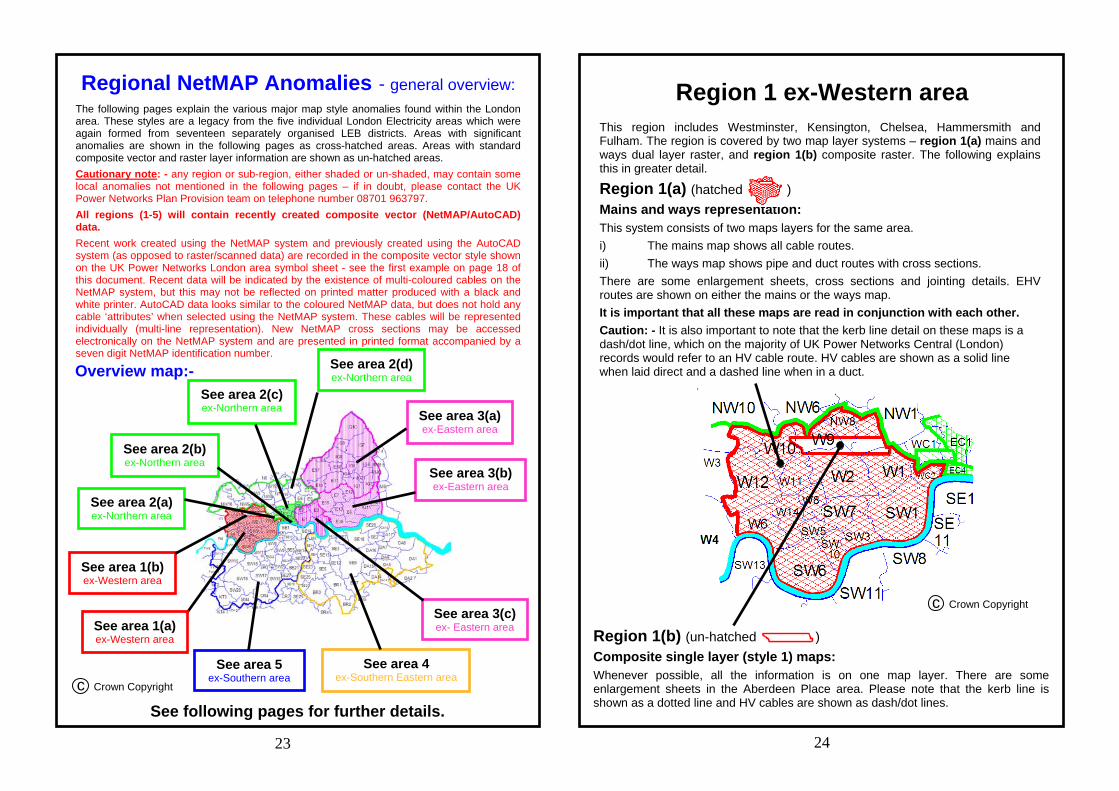
This region includes Westminster, Kensington, Chelsea, Hammersmith and Fulham. The region is covered by two map layer systems – region 1(a) mains and ways dual layer raster, and region 1(b) composite raster. The following explains this in greater detail.
Region 1(a) (hatched ) Mains and ways representation: This system consists of two maps layers for the same area. i) The mains map shows all cable routes. ii) The ways map shows pipe and duct routes with cross sections. There are some enlargement sheets, cross sections and jointing details. EHV routes are shown on either the mains or the ways map. It is important that all these maps are read in conjunction with each other. Caution: - It is also important to note that the kerb line detail on these maps is a dash/dot line, which on the majority of UK Power Networks Central (London) records would refer to an HV cable route. HV cables are shown as a solid line when laid direct and a dashed line when in a duct.
Region 1 ex-Western area
Region 1(b) (un-hatched ) Composite single layer (style 1) maps: Whenever possible, all the information is on one map layer. There are some enlargement sheets in the Aberdeen Place area. Please note that the kerb line is shown as a dotted line and HV cables are shown as dash/dot lines.
See area 3(c)ex- Eastern area
See area 3(b)ex-Eastern area
See area 3(a)ex-Eastern area
See area 2(d)ex-Northern area
See area 2(c) ex-Northern area
See area 2(b)ex-Northern area
See area 2(a)ex-Northern area
See area 1(b)ex-Western area
See area 1(a)ex-Western area
See area 5 ex-Southern area
See area 4ex-Southern Eastern area
23 24
Regional NetMAP Anomalies - general overview: The following pages explain the various major map style anomalies found within the London area. These styles are a legacy from the five individual London Electricity areas which were again formed from seventeen separately organised LEB districts. Areas with significant anomalies are shown in the following pages as cross-hatched areas. Areas with standard composite vector and raster layer information are shown as un-hatched areas. Cautionary note: - any region or sub-region, either shaded or un-shaded, may contain some local anomalies not mentioned in the following pages – if in doubt, please contact the UK Power Networks Plan Provision team on telephone number 08701 963797. All regions (1-5) will contain recently created composite vector (NetMAP/AutoCAD) data. Recent work created using the NetMAP system and previously created using the AutoCAD system (as opposed to raster/scanned data) are recorded in the composite vector style shown on the UK Power Networks London area symbol sheet - see the first example on page 18 of this document. Recent data will be indicated by the existence of multi-coloured cables on the NetMAP system, but this may not be reflected on printed matter produced with a black and white printer. AutoCAD data looks similar to the coloured NetMAP data, but does not hold any cable ‘attributes’ when selected using the NetMAP system. These cables will be represented individually (multi-line representation). New NetMAP cross sections may be accessed electronically on the NetMAP system and are presented in printed format accompanied by a seven digit NetMAP identification number.
See following pages for further details.
Overview map:-
c Crown Copyright
c Crown Copyright
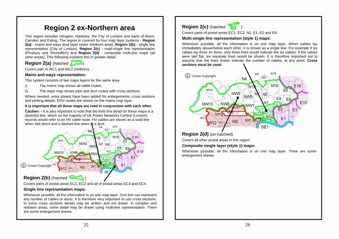
Region 2 ex-Northern area This region includes Islington, Hackney, the City of London and parts of Brent, Camden and Ealing. The region is covered by four map layer systems - Region 2(a) - mains and ways dual layer raster (Holborn area), Region 2(b) - single line representation (City of London), Region 2(c) - multi-single line representation (Finsbury and Shoreditch) and Region 2(d) - composite multi-line maps (all other areas). This following explains this in greater detail. Region 2(a) (hatched ) Covers part of WC1 and WC2 (Holborn). Mains and ways representation: This system consists of two maps layers for the same area. i) The mains map shows all cable routes. ii) The ways map shows pipe and duct routes with cross sections. Where needed, extra sheets have been added for enlargements, cross sections and jointing details. EHV routes are shown on the mains map layer. It is important that all these maps are read in conjunction with each other. Caution: - It is also important to note that the kerb line detail on these maps is a dash/dot line, which on the majority of UK Power Networks Central (London) records would refer to an HV cable route. HV cables are shown as a solid line when laid direct and a dashed line when in a duct.
Region 2(c) (hatched ) Covers parts of postal areas EC1, EC2, N1, E1, E2 and E8. Multi-single line representation (style 1) maps: Whenever possible, all the information is on one map layer. When cables lay immediately above/below each other, it is shown as a single line. For example if six cables lay three on three, only three lines would indicate the six cables. If the cables were laid flat, six separate lines would be shown. It is therefore important not to assume that the lines drawn indicate the number of cables, at any point. Cross sections must be used.
25 26
c Crown Copyright
Region 2(b) (hatched ) Covers parts of postal areas EC1, EC2 and all of postal areas EC3 and EC4. Single line representation maps: Whenever possible, all the information is on one map layer .One line can represent any number of cables or ducts. It is therefore very important to use cross sections. In some cross sections details may be written and not drawn. In complex and redrawn areas, some detail may be drawn using multi-line representation. There are some enlargement sheets.
Region 2(d) (un-hatched) Covers all other postal areas in this region Composite single layer (style 1) maps: Whenever possible, all the information is on one map layer. There are some enlargement sheets.
c Crown Copyright
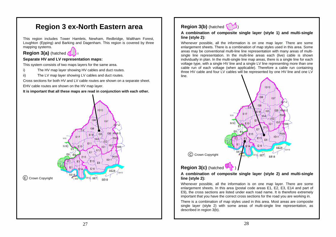
Region 3(b) (hatched ) A combination of composite single layer (style 1) and multi-single line (style 2): Whenever possible, all the information is on one map layer. There are some enlargement sheets. There is a combination of map styles used in this area. Some areas may be conventional multi-line line representation with many areas of multi-single line representation. In the multi-line areas each (live) cable is shown individually in plan. In the multi-single line map areas, there is a single line for each voltage type, with a single HV line and a single LV line representing more than one cable run of each voltage (when applicable). Therefore a cable run containing three HV cable and four LV cables will be represented by one HV line and one LV line.
Region 3 ex-North Eastern area This region includes Tower Hamlets, Newham, Redbridge, Waltham Forest, Loughton (Epping) and Barking and Dagenham. This region is covered by three mapping systems.
Region 3(a) (hatched ) Separate HV and LV representation maps: This system consists of two maps layers for the same area. i) The HV map layer showing HV cables and duct routes. ii) The LV map layer showing LV cables and duct routes. Cross sections for both HV and LV cable routes are shown on a separate sheet. EHV cable routes are shown on the HV map layer. It is important that all these maps are read in conjunction with each other.
Region 3(c) (hatched ) A combination of composite single layer (style 2) and multi-single line (style 2): Whenever possible, all the information is on one map layer. There are some enlargement sheets. In this area (postal code areas E1, E2, E3, E14 and part of E9), the cross sections are listed under each road name. It is therefore extremely important that you have the correct cross sections for the road you are working in. There is a combination of map styles used in this area. Most areas are composite single layer (style 2) with some areas of multi-single line representation, as described in region 3(b).
27 28
c Crown Copyright
c Crown Copyright
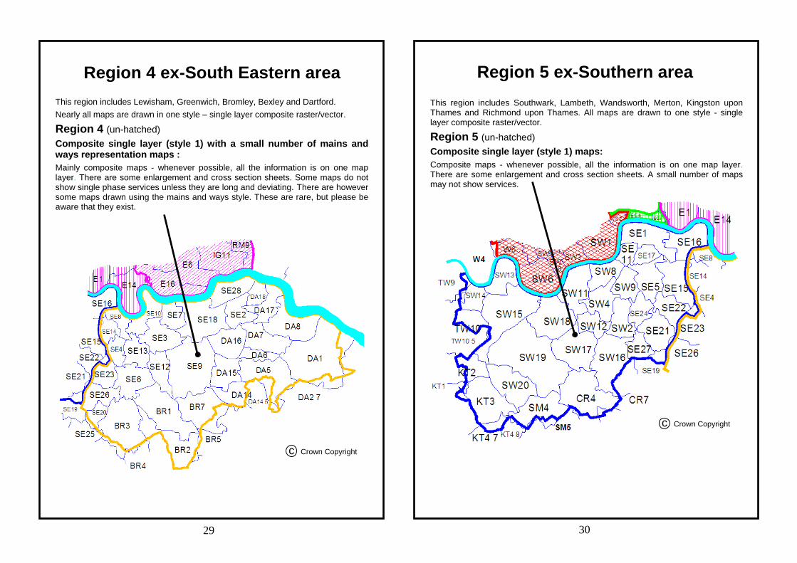
Region 4 ex-South Eastern area This region includes Lewisham, Greenwich, Bromley, Bexley and Dartford. Nearly all maps are drawn in one style – single layer composite raster/vector.
Region 4 (un-hatched) Composite single layer (style 1) with a small number of mains and ways representation maps : Mainly composite maps - whenever possible, all the information is on one map layer. There are some enlargement and cross section sheets. Some maps do not show single phase services unless they are long and deviating. There are however some maps drawn using the mains and ways style. These are rare, but please be aware that they exist.
Region 5 ex-Southern area This region includes Southwark, Lambeth, Wandsworth, Merton, Kingston upon Thames and Richmond upon Thames. All maps are drawn to one style - single layer composite raster/vector.
Region 5 (un-hatched) Composite single layer (style 1) maps: Composite maps - whenever possible, all the information is on one map layer. There are some enlargement and cross section sheets. A small number of maps may not show services.
29 30
c Crown Copyright
c Crown Copyright


![Empirical Evaluation of ICT Adoption in Australian …iceb.johogo.com/proceedings/2006/defevent/papers/cr1031.pdfconnectivity (NetMap), and participant observation] we have changed](https://img.pdfslide.us/doc/110x75/5ea6d5168e1d0c048a4792b4/empirical-evaluation-of-ict-adoption-in-australian-iceb-connectivity-netmap.jpg)


![Quantifiers, Unit Symbols, Chemical Symbols and Symbols of ... · [Technical Data] Quantifiers, Unit Symbols, Chemical Symbols and Symbols of Elements Excerpts from JIS Z 8202 Calculation](https://img.pdfslide.us/doc/110x75/5f3249d403d3070d9018fe62/quantifiers-unit-symbols-chemical-symbols-and-symbols-of-technical-data.jpg)