Embed Size (px)
Citation preview

WORLD RESOURCES REPORT http://www.worldresourcesreport.org/
Nepal: Responding Proactively to Glacial Hazards
World Resources Report Case Study
SUSAN TAMBI MATAMBO, INDEPENDENT CONSULTANT
ARUN BHAKTA SHRESTHA, INTERNATIONAL CENTRE FOR INTEGRATED MOUNTAIN DEVELOPMENT, NEPAL
Suggested Citation: Matambo, Susan and Arun Shrestha. “World Resources
Report Case Study. Nepal: Responding Proactively to Glacial Hazards.”
World Resources Report, Washington DC. Available online at
http://www.worldresourcesreport.org
INTRODUCTION
Glaciers hold about 70% of the earth’s freshwater
(UNEP, 2002). They cover about 17% of the total
area of the mountainous Hindu Kush-Himalayan
(HKH) region of south and eastern Asia (Xu et al.,
2007). Ten of the greatest rivers of Asia have their
headwaters in the Hindu Kush-Himalayan
Mountains. Thus, these mountains are often called
“the water towers of Asia” (ICIMOD, 2009). Nepal
is a small land-locked country in South Asia,
occupying an area of 147,181 km2 and with a
population of about 29 million people (The World
Bank Group, 2009). A major portion of the
country's territory is occupied by mountainous
terrain, which contains large numbers of glaciers
and glacial lakes, as well as being home to 8 of the
10 highest mountain peaks in the world, including
Mount Everest (8848 m). Glaciers cover about 9.6%
of Nepal’s total land area (Sharma, 2010; ICIMOD,
2001). These glaciers are huge reservoirs of
freshwater in frozen form which maintain the
perennial flow of the major rivers of Nepal as well
as the Ganges in India. As a result, changes in the
hydrology of Nepalese rivers due to deglaciation
could have regional consequences for water
resource availability (Germanwatch, 2004).
Glaciers are particularly susceptible to changing
temperatures. It has been estimated that temperature
rises of 0.04-0.09◦ C/year are occurring in Nepal,
with greater warming at higher altitudes (Shrestha
et al., 1999; Xu et al., 2007). Warmer temperatures
cause accelerated melting of glacial ice, resulting in
shrinkage of glaciers. This can lead to the formation
of glacial lakes, some of which may burst out and
cause flash floods known as glacial lake outburst
floods (GLOFs) downstream in the valleys. The
potential for loss of life and damage to
infrastructure due to glacial lake outburst floods is
varied depending on factors such as the size and
depth of the lake, the nature of the outburst, the
geomorphology of the river valley and elements
exposed to the flash flood (Dixit & Gyawali, 1997;
Shrestha et al., 2010). It is believed that glacial lake
outburst floods may be one of the most important
water-induced hazards in Nepal, with the potential
to cause large socio-economic impacts in the
country (United Nations, 2009; Network-Nepal,
2009).
The Tsho Rolpa glacial lake, situated at the
headwaters of the Rolwaling River Valley, is the
largest moraine-dammed glacial lake in the Nepal
Himalaya. A moraine-dammed glacial lake is
World Resources Report: Decision Making in a Changing Climate
WORLD RESOURCES REPORT http://www.worldresourcesreport.org/
2
formed when piles of rock debris (moraines)
impound water behind them. These deposits of
debris are accumulated when a glacier retreats and
melts over a period of time. Moraine-walled lakes
are structurally weak and unstable, so there is
significant danger of catastrophic flooding due to
slope failure and slumping (Dahal, 2008; Ives,
1986; Rana et al., 2000). Tsho Rolpa is located at an
elevation of 4580 m above sea level. The lake has
been rapidly increasing in size since the 1950s and
currently has a total surface area of 1.65 km2
(Shrestha et al., 2001). Studies carried out in the
early 1990s suggested that the lake had reached a
dangerous level and had the potential to burst
(Damen, 1992). By the late 1990s, the glacial lake
outburst flood hazard became serious and
recommendations for lowering the lake water level
were made. Glacial lake outburst flood specialist
Dr. J. Reynolds warned that the lake might burst in
the summer of 1997 (Dixit & Gyawali, 1997).
Proactive decision making in response to risks that
are often fraught with uncertainty has historically
been difficult for decision makers. Thus, the
Nepalese government’s response to the threat of a
glacial lake outburst flood occurring from Tsho
Rolpa has received acclaim (IPCC, 2007). It was a
national-level intervention affecting several districts
in the region. The government installed physical
structures to reduce the level of the lake and a
warning system for residents residing downstream
of the lake. Evacuation of the residents living in
close vicinity of the lake was also carried out. The
whole intervention, particularly the construction of
an open channel to lower the glacial lake level, is
considered exemplary in the Hindu Kush-Himalaya
region, and is believed to have averted a glacial lake
outburst flood and reduced the risk for the time
being (Rana et al., 2000).
This case study illustrates the proactive response by
the Nepalese government to the imminent threat of
a glacial lake outburst flood on Tsho Rolpa Lake,
and describes the setting and history of this
intervention. It also portrays its successes and
failures. The intervention taken by the Nepalese
government in 1997 was not necessarily a proactive
response to long-term climate change, but was
rather taken as a disaster risk reduction intervention,
aimed at minimizing potential damage to
infrastructure and loss of life. This case remains
relevant, however, as more is known about the links
between deglaciation and climate change; the risks
posed to glacial lakes are likely to increase in a
changing climate. The Tsho Rolpa case may hold
lessons learned for governments and other
institutions faced with making decisions due to the
threat of glacial lake outburst floods.

World Resources Report: Decision Making in a Changing Climate
WORLD RESOURCES REPORT http://www.worldresourcesreport.org/
3
SETTING
Tsho Rolpa glacial lake is located about 110 km
north-east of Kathmandu in the Rolwaling Valley
(Figure 1) at the terminus or bottom end of
Trakarding Glacier, at an elevation of 4580 m above
sea level. The Rolwaling Valley is oriented in an
east-west direction and opens only to the west. It
takes 6 days to walk to the lake from Singati, where
the nearest road is located.
The creation of Tsho Rolpa Lake was reconstructed
by various studies (Figure 2); it is believed to have
been formed as a result of retreat, stagnation and
melting of the Trakarding Glacier (ICIMOD, 2009;
Rana et al., 2000). It is estimated that Tsho Rolpa
has been increasing in size since the 1950s: from an
area of 0.23 km2 in 1959 (Yamada, 1998), in 2009
the lake had an area of 1.54 km2 with a maximum
depth of 133.5 meters and volume of 85.94 x 10⁶ m
3
(ICIMOD, in prep).
Figure 2 shows that the lake is undergoing constant
growth due to intensive breaking
away of ice at the terminus of
Trakarding Glacier. The total
volume of water at present is
estimated to be about 80-90
million m3. The total catchment
area of the lake is 77.6 km2. The
temperature around the
surroundings of the lake drops to
-25◦C in winter and the lake
surface freezes by late November.
The main inflow into the lake is
from the Trakarding Glacier and
outflow can reach about 19 m3
per second during the monsoon
season (Yamada, 1998; Dixit &
Gyawali, 1997). It is estimated
that 7,000 people live along the
Rolwaling and Bhote/Tama Koshi Valleys
downstream from Tsho Rolpa (Dahal, 2008;
Meteorcomm LLC, n.d.).
While this case study focuses on the Tsho Rolpa
glacial lake, it is relevant to other glacial lakes in
Nepal and the region, and particularly for the
communities living downstream of glacial lakes. In
2001, the International Centre for Integrated
Mountain Development (ICIMOD), with support
from the United Nations Environmental Program
(UNEP), identified 2323 glacial lakes in Nepal,
twenty of which were categorized as potentially
dangerous (Network-Nepal, 2009; ICIMOD,
2001).1 As a result, several river basins of Nepal
are exposed to the threat of glacial lake outburst
1 The International Centre for Integrated Mountain
Development (ICIMOD) has conducted a new study between
2009 and 2010 on glacial lakes in Nepal, however the data is
yet to be published.
Figure 1: Map showing location of Tsho Rolpa glacial lake (Source: B.S. Rana, 2000)

World Resources Report: Decision Making in a Changing Climate
WORLD RESOURCES REPORT http://www.worldresourcesreport.org/
4
floods. However, some features of Tsho Rolpa
make it the most dangerous glacial lake in Nepal. It
is particularly susceptible to outburst as a result of
the size of the lake, its rapid growth rate, the
presence of numerous icebergs breaking off the
glacier causing displacement waves, its high and
narrow moraine dam, and the existence of dead ice
within the moraine, which is gradually melting.
HISTORICAL CONTEXT
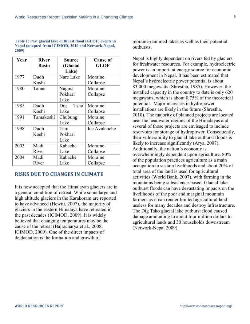
Glacial lake outburst floods are not new in Nepal.
There is evidence of a glacial lake outburst flood
that occurred some 450 years ago (Dixit & Gyawali,
2007; Dahal, 2008; ICIMOD, 2009). Since 1964,
seven major documented glacial lake outburst
floods have occurred in the country (Network-
Nepal, 2009; see Table 1). Dixit & Gyawali (1997)
argue that glacial lake outburst floods first drew the
attention of scientists and decision makers only
after the disastrous outburst of the Dig Tsho Glacial
Lake in 1985. The outburst of Dig Tsho caused
devastating financial losses and damage to
infrastructure, including a recently constructed
hydroelectric power plant, 14 bridges, 30 houses
and farmland worth four million dollars, and led to
the loss of five lives (Network-Nepal, 2009; Dahal,
2008).
The potential threat of a glacial lake outburst flood
from Tsho Rolpa Lake also drew enormous media
attention in late 1997 after Dr. Reynolds’s
recommendations to lower the lake level. The
Government of Nepal’s reaction was based on
scientifically-based recommendations from experts.
It is believed that the enormous media attention
both locally and internationally could also have
contributed to the government’s proactive response
to the potential threat of an outburst flood from
Tsho Rolpa Lake (CNN; Dixit & Gywali, 2007;
Discount Pashmina, n.d.).
Figure 2: Growth of Tsho Rolpa (Source: Shrestha,
M.L. & Shrestha, A.B., 2004)
World Resources Report: Decision Making in a Changing Climate
WORLD RESOURCES REPORT http://www.worldresourcesreport.org/
5
Table 1: Past glacial lake outburst flood (GLOF) events in
Nepal (adapted from ICIMOD, 2010 and Network-Nepal,
2009)
Year River
Basin
Source
(Glacial
Lake)
Cause of
GLOF
1977 Dudh
Koshi
Nare Lake Moraine
Collapse
1980 Tamar Nagma
Pokhari
Lake
Moraine
Collapse
1985 Dudh
Koshi
Dig Tsho
Lake
Moraine
Collapse
1991 Tamakoshi Chubung
Lake
Moraine
Collapse
1998 Dudh
Koshi
Tam
Pokhari
Lake
Ice Avalanche
2003 Madi
River
Kabache
Lake
Moraine
Collapse
2004 Madi
River
Kabache
Lake
Moraine
Collapse
RISKS DUE TO CHANGES IN CLIMATE
It is now accepted that the Himalayan glaciers are in
a general condition of retreat. While some large and
high altitude glaciers in the Karakoram are reported
to have advanced (Hewitt, 2007), the majority of
glaciers in the eastern Himalaya have retreated in
the past decades (ICIMOD, 2009). It is widely
believed that changing temperatures may be the
cause of the retreat (Bajracharya et al., 2008;
ICIMOD, 2009). One of the direct impacts of
deglaciation is the formation and growth of
moraine-dammed lakes as well as their potential
outbursts.
Nepal is highly dependent on rivers fed by glaciers
for freshwater resources. For example, hydroelectric
power is an important energy source for economic
development in Nepal. It has been estimated that
Nepal’s hydroelectric power potential is about
83,000 megawatts (Shrestha, 1985). However, the
installed capacity in the country to date is only 620
megawatts, which is about 0.75% of the theoretical
potential. Major increases in hydropower
installations are likely in the future (Shrestha,
2010). The majority of planned projects are located
near the headwater regions of the Himalayas and
several of those projects are envisaged to include
reservoirs for storage of hydropower. Consequently,
their vulnerability to glacial lake outburst floods is
likely to increase significantly (Arya, 2007).
Additionally, the nation’s economy is
overwhelmingly dependent upon agriculture. 80%
of the population practices agriculture as a main
occupation to sustain livelihoods and about 20% of
total area of the land is used for agricultural
activities (World Bank, 2007), with farming in the
mountains being subsistence-based. Glacial lake
outburst floods can have devastating impacts on the
livelihoods of the poor and marginal mountain
farmers as it can render limited agricultural land
useless for many decades and destroy infrastructure.
The Dig Tsho glacial lake outburst flood caused
damage amounting to about four million dollars to
agricultural lands and 30 households downstream
(Network-Nepal 2009).

World Resources Report: Decision Making in a Changing Climate
WORLD RESOURCES REPORT http://www.worldresourcesreport.org/
6
If an outburst of Tsho Rolpa were to occur it would
have disastrous wide-scale impacts, due to its
topology, location, and the communities and
ecosystems dependent
upon its water resources
(Rana et al., 2000;
DHM, 1998). Damage
would be felt 100 km
downstream (Network-
Nepal, 2009). Tsho
Rolpa’s hazardous
glacial lake outburst
flood potential was
identified as early as
1987, prompting the
Water and Energy
Commission Secretariat
under the Ministry of
Water Resources to
make detailed
investigations in 1993
(Dixit & Gyawali,
1997). Field studies and
analyses of the lake’s
development stages supplemented available maps,
aerial photographs and satellite imagery.
At risk are lives, livelihoods, infrastructure such as
dams, hydropower stations, biodiversity, water
supplies and health. According to a recent study
conducted by the International Centre for Integrated
Mountain Development, about 5,200 people and
1,150 households are directly exposed to a potential
glacial lake outburst flood from Tsho Rolpa Lake.
Roughly 46 settlements, 400 acres of agricultural
land, 10 km of road, 40 km of foot trails, 16 km of
irrigation canals, and 21 trail bridges are at risk of a
potential Tsho Rolpa glacial lake outburst flood.
Several hydropower stations are in the pipeline for
construction and would also be at risk from a flood
(ICIMOD, 2009). According to the study, the total
value of the elements exposed to potential glacial
lake outburst floods was estimated between
US$1.85 million and US$8.78 million (ICIMOD, in
prep.). Box 1 describes the characteristics of the
risks that glacial lake outburst floods pose.
EXISTING POLICY AND LEGISLATION
Upon close examination and according to
Shrestha (2010), there is currently no
overarching policy or plan that is directly
targeting glacial lake outburst flood risk
management in Nepal. However, according
to the Nepal Disaster Relief Report 2009,
there is some sort of intra-governmental
coordination for the management of flood-
related disasters in Nepal. It is worth
mentioning that flood disaster management
in Nepal includes prevention, preparedness,
rescue and relief, and reconstruction and
rehabilitation, which can be applied to
glacial lake outburst floods. Local
communities are involved at various stages.
The following documents and policies in
Box 1: The Characteristics of Glacial Lake Outburst Flood Impact Risks
Uncertainty: Even though scientists can approximate that a glacial lake is about to burst, it is not
always clear exactly when it could happen. A glacial lake outburst flood can be triggered by
various elements such as rock/ice avalanche, earthquake, ice calving. Presence of such elements
can be identified but it cannot be predicted when an avalanche or earthquake can occur.
Changes in mean climate system: The formation and growth of glacial lakes in Nepal, including
Tsho Rolpa can be attributed to climate change. Studies conducted in the past have suggested that
there is significant warming trend over Nepal and the warming rates increase progressively with
elevation (A. W. Shrestha 1999, Xu 2007).
Time lag and sudden change: Glacial lake outburst floods build up slowly over time and can
occur unexpectedly, causing the need for both long-term preventative measures and fast-reacting
mechanisms to contend with these events.
Spatial dimensions (widespread impacts): The spatial dimension of the glacial lake outburst
flood impact can be largely variable and will depend on the size of the lake, characteristics of the
release of the water, and geomorphologic configuration of the valley downstream. A glacial lake
outburst flood includes water flowing at a very high velocity and mixed with large amount of
debris. The extent of damage within the impact area can be quite extensive. Further the indirect
impact due to loss of transportation means, hydropower generation, etc., can be of national scale
(Shrestha et al., 2010; ICIMOD, in prep).

World Resources Report: Decision Making in a Changing Climate
WORLD RESOURCES REPORT http://www.worldresourcesreport.org/
7
Nepal do not specifically target glacial lake
outburst flood risk management, but they do
recognize glacial lake outburst floods within
an overall strategy for flood risk
management in Nepal. Nevertheless, they
may have enhanced Nepal’s capacity to
manage flood-related disasters. They
include:
Natural Disaster Relief Act, 1982
National Action Plan for Disaster
Management in Nepal, 1996
Tenth Five-Year Plan (2002-2007)2
National Water Plan, 2005
Water Induced Disaster Management
Policy, 2006
National Policy and Strategy for Disaster
Risk Management, 2007
National Strategy for Disaster Risk
Management, 2009
Disaster Risk Management Act (draft)
POLICY INTERVENTION
The Government of Nepal in 1997 undertook both
short-term and long-term measures to avert a
disastrous glacial lake outburst flood event from
Tsho Rolpa to reduce the extent of damage that it
could cause. Box 2 lists the key players involved in
the intervention. The measures taken can broadly be
put under three categories:
Physical structures
These were installed to reduce the size of the lake.
This included a) installation of test siphons3 and b)
2 This is the first time disaster risk reduction was addressed in
planning. 3 Siphons are high-density polythene pipes placed on the lake.
The pipes passed over the moraine ridge to the outer flank of
the moraine. Once primed, a vacuum is created due to a
construction of a gated open channel on the moraine
for controlled release of lake water to lower the lake
level by 3 m. The lowering of the lake was
conducted with support from the government of the
Netherlands (Dahal, 2008). The construction was
completed in 2000.
An emergency warning system
Initially in 1997, the Nepalese government set up
temporary army camps at different locations along
the Rolwaling Valley downstream of the lake to
warn people through Nepal’s main radio station that
a glacial lake outburst flood event had occurred.
This measure was soon withdrawn for a more
sophisticated system which was constructed with
assistance from the World Bank and installed by
Meteorcomm LLC, a private sector company from
the United States (Discount Pashmina, n.d.). This
system is described below:
1. Installation of an automated glacial lake
outburst flood sensor system with support from
the World Bank. This included automatic flood
sensors located just below Tsho Rolpa to detect
changes in outflow from the lake, complete with
a redundancy component to minimize false
alarms.
2. A telemetric communication system to convey
the occurrence of an outburst flood event to
warning stations that were installed along the
Rolwaling and Bhote/Tama Koshi Valleys. This
was installed to warn people if the glacial lake
outburst flood event occurred. The warning
system was based on a VHF radio technology
and would relay any alarm from the sensors
located immediately downstream of Tsho Rolpa
to the warning stations along the valley. The
warning was issued by air horns backed up by
electronic sirens (Meteorcomm LLC, 2010).
Data management centers were set up to
difference in pressure in the inlet and outlet, which keeps the
water flowing without the need of pumping.

World Resources Report: Decision Making in a Changing Climate
WORLD RESOURCES REPORT http://www.worldresourcesreport.org/
8
monitor system performance. These were
manned by expert personnel.
3. A meteor burst master
station which uses the
ionized trails of meteors
to extend the range of the
transmitted radio signals
to over 1,000 miles was
constructed. Several of
the warning stations, as
well as a sensing station,
transmit and receive
signals from the master
station, to provide further
redundancy to the system
in the event that two or
more successive stations
should fail. The master
station also monitors the
status of the entire
warning system
(Meteorcomm LLC, 2010; Bell et al., 1999).
Evacuation
Voluntary evacuation of the inhabitants of the
valleys downstream who would have been directly
affected by flooding from Tsho Rolpa took place.
The lowering of the lake level at Tsho Rolpa glacial
lake is believed to have averted a major disaster.
Tsho Rolpa is the only lake in Nepal for which such
measures have been taken (Dahal, 2008; Rana et al.,
2000; Shrestha & Shrestha, 2004). The construction
of an open channel and the set-up of early warning
systems took place in the district between 1997 and
1998 (Dixit & Gyawali, 1997). The open channel
structures are still functional today. By 2002,
however, the Tsho Rolpa early warning systems had
ceased to be in operation and there are indications
that the threat has long been forgotten by the local
communities (Dahal, 2008). Some sources and
reports including the Nepal Disaster Report of 2009
indicate that the early warning systems are still
dysfunctional today (Dixit, 2011).
DETAILED TIMELINE OF THE TSHO ROLPA GLACIAL LAKE INTERVENTION
A summary of the events that led to the government
of Nepal’s response to a potential outburst at Tsho
Rolpa Glacial Lake is given below.
Research and Recommendations
Preliminary studies of Tsho Rolpa glacial lake
began in 1992 after the Chubung glacial lake
outburst flood4 in 1991 (Thomson, 1992). Michiel
Damen, a geomorphologist of the International
Institute for Aerospace Survey and Earth Sciences
ITC in Enschede, Netherlands, prepared the first
detailed report entitled “Study on the Potential
Outburst Flooding of Tsho Rolpa Glacier Lake
Rolwaling Valley, East Nepal” in 1992. He
recommended lowering the lake level by several
4 See Table 1
Box 2: Key players involved in intervention
Government: Ultimate decision maker provided the political clout and coordination
amongst ministries that was required to respond to threat fairly quickly. The
installation of the test siphons and manual early warning system was a coordinated
effort of the Department of Hydrology and Meteorology, Nepal Army, Nepal Police,
Ministry of Home Affairs, and Department of Water Supply. The Department of
Hydrology and Meteorology led the coordination.
Donor agencies: Provided the necessary funding, capacity and installation of the
early warning systems. The World Bank provided the funding for the meteor burst
early warning system and the Government of Netherlands provided funds for the
construction of the open channel through the moraine.
Press: Reported on the threat and provided warning to residents.
Scientists: Performed studies of the lake, bringing in new technologies for survey;
risk assessment.
World Resources Report: Decision Making in a Changing Climate
WORLD RESOURCES REPORT http://www.worldresourcesreport.org/
9
meters using a siphon over the southwest side of the
end moraine. Further, he recommended monitoring
the lake level fluctuation and the discharge of the
Rolwaling Khola River in the Rolwaling Valley
(Damen, 1992).
In 1993, more detailed qualitative and quantitative
work was carried out by the Water and Energy
Commission Secretariat of Nepal, with support
from the Japanese International Cooperation
Agency (Mool, 1993). This work included studies
of the growth pattern and size of the lake,
bathymetric and topographic surveys of
downstream villages, and river cross-sections. The
Secretariat continued to carry out the studies on
glacial lakes and prepared a series of interim reports
(Yamada & Sharma, 1993).
A further study of debris flow and hazard
assessment due to glacial lake outburst floods in the
Rolwaling Valley was also carried out in the mid-
1990s (Fujiwara, 1995; J. Reynolds, 1994).
Distribution of buried ice was evaluated in 1995
using electrical resistivity exploration at the end
moraine of Tsho Rolpa. This study suggested that
ice masses were present within the lake.
Modder and Olden, two students from the Free
University of Amsterdam, conducted the
geotechnical hazard analysis of the Tsho Rolpa
Lake. They concluded that on an engineering
timescale (50–100 years), the dam was considered
to be stable provided that no large-scale events such
as earthquakes occurred. However, on a
geomorphological timescale (>100 years), moraine
dam failure would eventually take place if no
counter-measures were taken (Modder, 1995). The
study did not take into account climate change.
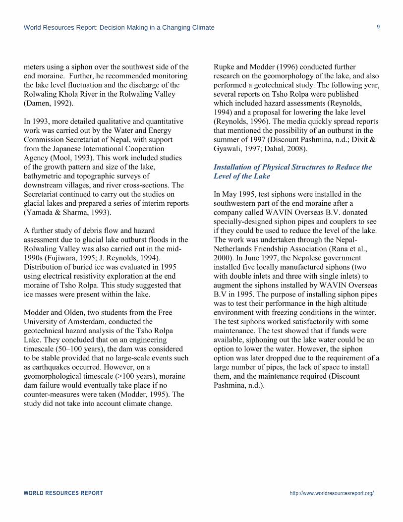
Rupke and Modder (1996) conducted further
research on the geomorphology of the lake, and also
performed a geotechnical study. The following year,
several reports on Tsho Rolpa were published
which included hazard assessments (Reynolds,
1994) and a proposal for lowering the lake level
(Reynolds, 1996). The media quickly spread reports
that mentioned the possibility of an outburst in the
summer of 1997 (Discount Pashmina, n.d.; Dixit &
Gyawali, 1997; Dahal, 2008).
Installation of Physical Structures to Reduce the
Level of the Lake
In May 1995, test siphons were installed in the
southwestern part of the end moraine after a
company called WAVIN Overseas B.V. donated
specially-designed siphon pipes and couplers to see
if they could be used to reduce the level of the lake.
The work was undertaken through the Nepal-
Netherlands Friendship Association (Rana et al.,
2000). In June 1997, the Nepalese government
installed five locally manufactured siphons (two
with double inlets and three with single inlets) to
augment the siphons installed by WAVIN Overseas
B.V in 1995. The purpose of installing siphon pipes
was to test their performance in the high altitude
environment with freezing conditions in the winter.
The test siphons worked satisfactorily with some
maintenance. The test showed that if funds were
available, siphoning out the lake water could be an
option to lower the water. However, the siphon
option was later dropped due to the requirement of a
large number of pipes, the lack of space to install
them, and the maintenance required (Discount
Pashmina, n.d.).

World Resources Report: Decision Making in a Changing Climate
WORLD RESOURCES REPORT http://www.worldresourcesreport.org/
10
In August 1997, a team which included
international and national experts visited the lake
and recommended lowering the lake level by 3 m
by cutting an open channel in the southwest part of
the end moraine (DHM, 1997). The Netherlands
government funded this project, for which a grant
agreement for the Tsho Rolpa Glacial Lake
Outburst Flood Risk Reduction Project was signed
in August 1998 between the Netherlands and the
Government of Nepal. The objective of the 3 m lake
lowering was to reduce the water level, which
would immediately and tangibly reduce the risk of a
breach forming in the natural moraine dam. This
flood risk reduction system consisted of a lined
channel constructed through the western end
moraine (DHM, 1998). The work was 90%
complete when construction was halted for the
winter shutdown in October 1999 (DHM, 2000).
The construction work began again in April 2000
and was completed by the middle of July 2000,
lowering the lake level by 3 m (See Figure 3).
Installation of Early Warning and Sensor Systems
In June 1997, the Government of Nepal established
an early warning system at Tsho Rolpa, by building
a temporary Nepalese Army post at the lake, as well
as police posts downstream. These posts were
equipped with satellite phones and radios so that
inhabitants of
downstream locations, as
well as the Khimti
Hydropower Project,
could be informed on a
timely basis of a potential
glacial lake outburst
flood through Nepal’s
main radio station.
A year later (before the
monsoon of 1998), the
Department of Hydrology
and Meteorology
established the meteor burst system, a type of early
warning system, to provide the inhabitants of the
Rolwaling and Bhote/Tama Koshi Valleys with
early information about a glacial lake outburst
flood, thereby allowing them time to reach a safe
location and save lives and valuables. The timing
was critical as the probability of glacial lake
outburst floods is higher during the monsoon. The
meteor burst system consisted of a glacial lake
outburst flood sensing system located just
downstream of the end moraine. When a flood is
sensed, a warning is relayed to 19 stations located
downstream, equipped with audible alarms (see
Figure 4). This automated early warning system was
established with financial support from the World
Bank.
Evacuation of Downstream Residents
Once it was predicted that the lake would burst in
the summer of 1997, an evacuation order was issued
for residents downstream of Tsho Rolpa glacial
lake, in particular for those residing on the banks of
the Rolwaling River (Dolakha, 2008.; Dixit &
Gyawali, 1997). It is estimated that 74% of the 6000
or so residents moved to safer places for at least one
month (Dahal, 2008). Those who responded to the
evacuation moved 20 m up from the river bank
(Dolakha, 2008).
Figure 3: Open channel constructed in Tsho Rolpa (Source: Arun Shrestha)

World Resources Report: Decision Making in a Changing Climate
WORLD RESOURCES REPORT http://www.worldresourcesreport.org/
11
Figure 4: Tsho Rolpa's early warning system (Source:
Arun Shrestha)
OUTCOMES
The structure constructed to lower the lake level at
Tsho Rolpa is still perfectly functional. It is
believed that the efforts to lower the lake averted
the immediate glacial lake outburst flood risk. The
water flowing out of the open channel was tapped to
run a small micro-hydro plant that has been
powering the site, which is manned throughout the
year, securing the energy sustainability of the
project (Arya, 2007).
However, relocation of residents living within the
vicinity of the lake downstream and the
implementation of the early warning system have
not been a success. First of all, information about an
imminent glacial lake outburst flood from Tsho
Rolpa trickling from the government to the
residents downstream of the lake was largely
ignored and dismissed by the residents as “mere
rumor” (Dixit & Gyawali, 1997). This was due in
part to what some believe to have been exaggeration
by the media and in part to cultural norms regarding
risk perception (Dixit & Gyawali, 1997; Dahal,
2008). This hindered the process of relocation of the
residents to a large extent and was a factor in the
somewhat unsuccessful outcome of the early
warning systems developed for the Tsho Rolpa case
in the long run. Roughly four years after their
establishment, the early warning systems that were
installed at Tsho Rolpa were no longer operating
despite the fact that a robust system was
commissioned with the latest technology. Long
forgotten by the communities, it lies idle even today
(Network-Nepal, 2009).
The sections below discuss the factors that led to
policy change and the advancement of interventions
to contend with glacial lake outburst flood, as well
as hurdles to success, especially with regard to the
early warning systems.
REASONS FOR SUCCESS
On close examination, it can be deduced that the
measures taken at Tsho Rolpa to avert a potential
disaster from a glacial lake outburst flood were
successful. The Nepalese government responded
proactively to an imminent disaster in 1997 and set
prevention and early warning systems in place fairly
quickly. The government’s ability to collaborate
with donor agencies was critical to the rapid pace of
developments. Also, scientists were allowed to
engage in the policy process, which contributed to
the success of this intervention. The project was
implemented after a detailed investigation and had a
very sound scientific and technical basis (DHM,
1997). In addition, the ability of the Nepalese
government to make largely unilateral decisions
may have been an advantage (anonymous sources).
Also, the local people played active roles in the
construction of the physical structures to lower the
lake level as well as the early warning systems
(Shrestha, 2010). The VHF radio at the lake site
World Resources Report: Decision Making in a Changing Climate
WORLD RESOURCES REPORT http://www.worldresourcesreport.org/
12
was for a long time the only means of
communication for the villagers, particularly during
emergencies, until mobile phones became common.
While seemingly small, this helped establish the
importance of the project in the heart of the local
people (Shrestha, 2007). Donor funding also was
made available fairly quickly to avert the
astronomical costs of building structures for
reducing the size of the lake and for installing the
early warning systems.
REASONS FOR FAILURE
Although the prevention measures were considered
a success, the Tsho Rolpa response as a whole was
not all successful. Reasons for failure to maintain
the early warning systems include the following:
Uncertainty
Predictions about glacial lake outbursts are fraught
with uncertainty. This is partly because the
literature and science on glacial lake outburst flood
hazards is relatively young (Dahal, 2008). Reports
claiming that Tsho Rolpa was to burst in the
summer of 1997 have been considered unfounded
by some (Dixit & Gyawali, 1997; Dahal, 2008).
Participation
There had been some interaction with the villagers
in the early days of the construction of physical
structures to lower the lake and install the early
warning system, and some training was provided on
how they should react if the warning siren went off
(Shrestha, 2010). However, there were no follow-up
interactions and participation in monitoring the
early warning systems gradually declined (Dixit &
Gyawali, 1997).
Risk Perceptions and Norms
Cultural norms and common folklore in Nepal
result in a tendency to “dismiss alarming rumors”
(Dixit & Gyawali, 1997; Dahal, 2008). This seemed
to have had an impact on the perceived lack of
response to warnings by local communities (Dixit &
Gyawali, 1997). Apparently, within one month after
the warnings, some relocated residents had already
returned to their homes (Dahal, 2008). The
perception of risk by the residents also seems to
have been low. Due to uncertainty about the actual
time that a glacial lake outburst flood can occur,
there is a high incidence of false alarms (Ives et al.,
2010; ICIMOD, 2009; Shrestha et al., 2010).
Dahal's 2008 research on risk perception of the
communities shows that, “A majority of them
demonstrated dissonant risk perception. No
adjustments have been adopted by the people at
individual level. The low risk perception on the part
of the riverine people is chiefly attributed to the cry-
wolf effect of the 1997 evacuation that followed the
unfounded expert prediction of a Tsho Rolpa
outburst.”
Communication
There appeared to be a communication gap between
experts and the local communities residing in the
downstream valleys about the risks that Tsho Rolpa
presented. This gap seems to exist today, as some
experts have even suggested that Tsho Rolpa be
lowered by a further 15 m (Pearce, 2000; Dahal,
2008). Reports of a possible outburst flood from
Tsho Rolpa in 1997 often included certain elements
of overstatement, in particular by the media (Dixit
& Gyawali, 1997). The cry-wolf effect of the
evacuation of residents in 1997 possibly led to a
“numbing” effect of risk perception of the
communities (Dahal, 2008), who today apparently
do not perceive Tsho Rolpa as a threat.
Political Unrest
Nepal underwent political upheaval in 1998.
According to the International Centre for Integrated
Mountain Development (various publications) and
Dixit & Gyawali (1997), there has been a lack of
World Resources Report: Decision Making in a Changing Climate
WORLD RESOURCES REPORT http://www.worldresourcesreport.org/
13
institutional capacity to maintain the systems due to
political unrest in Nepal for a long period after
1998. The lack of security at large due to the
insurgency in the country can also be blamed to a
certain extent as this hindered timely maintenance
of the system (Network-Nepal, 2009). Some parts
of the early warning systems were either stolen or
vandalized during the insurgency (C.T.C.S., 2008).
Funding and maintenance
The government did not secure funds for operating
and maintaining the warning systems as they
require monitoring and maintenance on a fairly
frequent basis (Discount Pashmina, n.d.). Without
proper maintenance the system has gradually
deteriorated to its present non-functional state
(Shrestha, 2010). Earlier, a small flood damaged the
glacial lake flood sensor, and gradually, it has been
reported, equipment from the warning stations has
been either vandalized or stolen. Solar panels and
batteries were the first to disappear (C.T.C.S., 2008;
Shrestha, 2010).
CONCLUSION
Nepal has gained tremendous experience in risk
management of glacial lake outburst floods due to
past floods and the threat of future events. National-
level scientific capability has increased, and
capacity is currently being built in local institutions
such as universities to increase knowledge.
However, with current knowledge and ongoing
research about the links between warming and
glacial retreat, it is imperative that other countries
with similar threats from glacial lake outburst
floods seek to partner with research institutions to
learn more about glacial lakes and their ability to
negatively impact the economy and the people
living within the vicinity of the lakes. Currently,
researchers from several universities in the United
States and Asia are carrying out long-term research
on the behavior of glacial lakes in Nepal,
particularly on Lake Imja.5 It is now possible to
assess the outburst flood risk of a lake and possible
damage to infrastructure and livelihoods to some
extent, using remote sensing and mapping. It must
however be understood that “precise determination
of the degree of risk is not possible. Nevertheless,
because it is well-established that glacial lakes have
discharged precipitously in the recent past (last 50
years) and caused loss of life and damage to
infrastructure farther downstream, it must be
assumed that other lakes in apparently similar
situations may do so at some time in the future.
Such risks must be analyzed (Ives, 2010).”
It is clear from this case study that proactive
decision making to prevent possible disaster is
imperative. Glacial lake outburst flood risk is a
reality in the Hindu Kush-Himalaya region and can
be reduced by implementing various structural and
non-structural measures. However, the costs of
construction of structures to prevent or reduce the
damages that can be caused by such outburst floods
are astronomically high, particularly for developing
countries like Nepal. The physical structures built at
Tsho Rolpa required both donor and private sector
funding. Nevertheless, proactive responses to
threats from glacial lake outburst floods are
essential for countries where the risks are high and
likely to increase due to glacial retreat as the
climate changes.
5 See University of Indiana, USA; Nagoya University and
Kyoto University, Japan.
World Resources Report: Decision Making in a Changing Climate
WORLD RESOURCES REPORT http://www.worldresourcesreport.org/
14
REFERENCES
Agrawala, S. Bridge over troubled waters: linking climate change and development. OECD, 2005.
Agrawala, S., Raksakulthai, V., Aaslt, M. V., Larsen, P., Smith, J. & Reynolds, J. Development and Climate
Change in Nepal: Focus on Water Resources and Hydropower (No.
COM/ENV/EPOC/DCD/DAC(2003)1/FINAL). Paris: European Organization for Co-operation and
Development (OECD), 2003.
Arya, R. C. "Revitalizing Small Hydropower in Nepal." International Conference on Small Hydropower -
Hydro Sri Lanka, 22-24 October 2007. 2007.
Bajracharya, S.R., Mool, P.K . & Shrestha, B.R. "Global Climate Change and Melting of Himalayan Glaciers."
In Melting Glaciers and Rising Sea Levels: Impacts and Implications, by Prabha Shastri Ranade (Ed.), 28-46.
India: The Icfai’s University Press, 2008.
Bell, W.W., Donich, T., Groves, K.L. & Sytsma, D. “Tsho Rolpa GLOF Warning System Project.” The
International Association for Hydro-Environment Engineering and Research (IAHR). 1999.
http://www.iahr.org/membersonly/grazproceedings99/pdf/C011.pdf (accessed February 2011).
C.T.C.S. Survey of GLOF early warning system for its re-establishment at Tsho Rolpa region. Report.
Kathmandu: ComTech Communication Services for the Department of Hydrology and Meteorology, 2008.
Chhetri, B. P. "DISASTER MANAGEMENT IN NEPAL: A REVIEW." Asian Disaster Relief Center. 1998.
www.adrc.asia/countryreport/NPL/NPLeng98/index.htm (accessed February 2011).
Dahal, K.H. "Hazard and Risk: Perception of Glacial Lake Outburst Flooding from Tsho Rolpa Lake, Nepal."
Michigan Technological University. 2008. http://www.geo.mtu.edu/~raman/papers2/KhilaMSNepalGLOF.pdf
(accessed February 2011).
Damen, M. C. J. Study on the Potential Outburst Flooding of Tsho Rolpa Glacier Lake, Rolwaling Valley, East
Nepal. Enschede: ITC, 1992.
Department of Hydrology and Meteorology. Glacier Lake Outburst Flood Study of the Tama Koshi Basin.
Kathmandu: Department of Hydrology and Meteorology, 2000.
Department of Hydrology and Meteorology. Initial National Communication of Nepal Under the United
Nations Framework Convention on Climate Change (UNFCCC). Kathmandu: Department of Hydrology and
Meteorology, 2004.
Department of Hydrology and Meteorology. Tsho Rolpa GLOF Risk Reduction Project. Formulation Mission
Final Report. Kathmandu: Department of Hydrology and Meteorology, 1997.

World Resources Report: Decision Making in a Changing Climate
WORLD RESOURCES REPORT http://www.worldresourcesreport.org/
15
Department of Hydrology and Meteorology. Tsho Rolpa GLOF Risk Reduction Project. Implementation Report.
Kathmandu: Department of Hydrology and Meteorology, 1998.
Discount Pashmina. Chronology of Tsho Rolpa GLOF Hazard Response. 2008.
http://discountpashmina.biz/glof/tsho-rolpa-04.html (accessed February 2011).
Dixit, A. & Gyawali, D. "How Distant is Nepali Science from Nepali Society? Lessons From the 1997 Tsho
Rolpa GLOF Panic." Water Nepal, 1997: 5-43.
Dixit, A., interview by Susan Matambo. (February 5, 2011).
Dolakha, M. Tsho Rolpa Glacier Lake, Dolakha Nepal. 2008. http://dolakhatown.blogspot.com/2008/01/tsho-
rolpa-glacier-lake-dolakha-nepal.html (accessed March 2011).
Dwivedi, S.K., Acharya, M. D. & Simard, R. "The Tam Pokhari Glacier Lake Outburst Flood of 3 September
1998." Journal of Nepal Geological Society, 22, 2000: 539-546.
Fujita, K. L. G., Thomson,Y., Agetha, T., Yasunari, Y., Kajikawa, A., Sakai, A. & Takeuchi, N. "Thirty Year
History of Glacier Melting in the Nepal Himalayas." Journal of Geophysical Research, 111, 2006: 1-6.
Fujiwara, K. & Gomi, T. The Debris Flow and the Hazard Due to GLOF in the Rolwaling Valley, Nepal.
Kathmandu: WECS N551.489 FUJ, 1995.
Germanwatch. Glacial Lake Outburst Floods: New Threats Due to Climate Change. Bonn: Germanwatch,
2004.
Hewitt, K. "Tributary Glacier Surges: An Eexceptional Concentration at Panmah Glacier, Karakoram
Himalaya." Journal of Glaciology, 2007: 181-187.
International Centre for Integrated Mountain Development. Himalayas – Water for 1.3 Billion People.
Kathmandu: International Centre for Integrated Mountain Development, 2009.
International Centre for Integrated Mountain Development. Inventory of Glaciers, Glacial Lakes and Glacial
Lake Outburst Floods, Monitoring and Early Warning Systems in the Hindu Kush- Himalayan Region. Bhutan.
Kathmandu: International Centre of Integrated Mountain Development and United Nations Environment
Programme (ICIMOD/UNEP), 2001.
International Centre for Integrated Mountain Development. The Changing Himalayas: Impact of Climate
Change on Water Resources and Livelihoods in the Greater Himalayas. Kathmandu: International Centre for
Integrated Mountain Development, 2009.
Intergovernmental Panel on Climate Change (IPCC). IPCC Fourth Assessment Report: Climate Change 2007.
2007. http://www.ipcc.ch/publications_and_data/ar4/wg2/en/ch17s17-2-2.html (accessed February 2011).

World Resources Report: Decision Making in a Changing Climate
WORLD RESOURCES REPORT http://www.worldresourcesreport.org/
16
Ives, J. D. Glacial Lake Outburst Floods and Risk Engineering in the Himalyas (ICIMOD Occasional Paper
No.5). Kathmandu: International Centre for Integrated Mountain Development, 1986.
Ives, J. D., Shrestha, R. B. & Mool, P. K. Formation of Glacial Lakes in the Hindu Kush-Himalayas and GLOF
Risk Assessment. Kathmandu: International Centre of Integrated Mountain Development, 2010.
Meteorcomm LLC. Tsho Rolpa Glacial Lake Outflow Warning System. 2010.
http://www.meteorcomm.com/wireless/tsho_rolpa.aspx (accessed February 2011).
Modder, S. & van Olden, Q. Field Study Report of Tsho Rolpa, Dolakha District, Nepal (Second Field Period).
Amsterdam: WECS/Vrije Universiteit, 1995.
Mool, K. P., Kadota, T., Pokharel, P. R. & Joshi, S. Interim Report on the Field Investigation on the Tsho Rolpa
Glacier Lake, Rolwaling Valley. Kathmandu: WECS Report No. 3/4/021193/1/1 Seq.No.436, 1993.
Network-Nepal, Government of Nepal – Ministry of Home Affairs and Nepal Disaster Preparedness. Nepal
Disaster Report.2009. Hazardscape and Vulnerability. Kathmandu: Ministry of Home Affairs Nepal, 2009.
Pearce, A. Meltdowns in the Mountains. 2000.
Pokharel, L.N. "Countermeasures at the Tsho Rolpa Glacier Lake." Asian Disaster Relief Center. n.d.
http://www.adrc.asia/management/NPL/TSHO_ROLPA_GLACIER_LAKE.html?Frame=yes?Frame=
(accessed February 2011).
Rana, B., Shrestha, R. B., Reynolds, J. M., Aryal, R., Pokhrel, A. & Budhathoki, K. P. "Hazard Assessment of
the Tsho Rolpa Glacier lake and Ongoing Remediation Measures." Journal of Nepal Geological Society, 22,
2000: 563-570.
Rana, B. et al. "Hazard Assessment of the Tsho Rolpa Glacier Lake and Ongoing Remediation Measures."
Journal of Nepal Geological Society, 2000: 563-570.
Reliefweb. NEPAL: Global warming swells glacial lakes, endangering thousands. September 16, 2010.
http://www.reliefweb.int/rw/rwb.nsf/db900SID/MUMA-89C7F5?OpenDocument (accessed December 2,
2010).
Reynolds, J. M. Assessment of the Present Status of the Tsho Rolpa Glacier Lake in Dolakha District of Nepal:
Supplementary Report. Unpublished. 1997.
Reynolds, J. M. Final Proposal for the Lowering of the Water Level at Tsho Rolpa Glacier Lake, Nepal, to
Minimize Potential GLOF Hazards (Report). Unpublished. 1996.
Reynolds, J. M. Hazard Assessment at Tsho Rolpa, Rolwaling Himal, Northern Nepal: Technical Report.
Report No: J9402.002 (December 1994). Unpublished. 1994.
World Resources Report: Decision Making in a Changing Climate
WORLD RESOURCES REPORT http://www.worldresourcesreport.org/
17
Reynolds, J. M. "Glacial hazard assessment at Tsho Rolpa, Rolwaling, Central Nepal." Quarterly Journal of
Engineering Geology & Hydrogeology, 1999: 209-214.
Rupke, J. & Modder, S. Tsho Rolpa Glacier Lake, Rolwaling, Nepal. Amsterdam: Alpine Geomorphology
Research Group, University of Amsterdam, 1996.
Sharma, B. Himalayas Unsettled by Melting Glaciers, More Avalanches. October 4, 2010.
http://ipsnews.net/news.asp?idnews=53044 (accessed October 15, 2010).
Shrestha, A. B. & Shrestha, M. L. Recent Trends and Potential Climate Change Impacts on Glacier
Retreat/Glacier Lakes in Nepal and Potential Adaptation Measures. Paris 2005: OECD, 2004.
Shrestha, A. B. & Aryal, R. "Climate Change in Nepal and its Impact on Himalayan Glaciers." Regional
Environmental Change. DOI;10.1007/s10113-010-0174-9, 2010.
Shrestha, A. B., Eriksson, M., Mool, P., Ghimire, P., Mishra, B. & Khanal, N. R. "Glacial Lake Outburst Flood
Risk Assessment of Sun Koshi Basin, Nepal." Geomatics, Natural Hazards and Risk, 1, 2010: 157-169.
Shrestha, A. B., Wake, C. P., Mayewski, P. A. & Dibb, J. E. "Maximum Temperature Trends in the Himalaya
and its Vicinity: An Analysis Based on Temperature Records from Nepal for the Period 1971-94." Journal of
Climate, 12, 1999: 2775-2787.
Shrestha, A. B., Rana, B., Aryal, R. & Pokhrel, A. P. "Hazard Assessment and Remediation Work at Tsho
Rolpa Glacier Lake, Rolwaling Himal, Nepal." Journal of Japanese Society of Civil Engineers, 86, 2001: 72-75.
Shrestha, A. B., interview by Susan Tambi Matambo. (2010).
Shrestha, H. M. "Water Power Potential." In Nepal - Nature's Paradise, T.C. Majupuria (Ed.), 4-8. Bangkok:
White Lotus Co. Ltd, 1985.
Thomson, R. "Rolwaling in Danger." Himal Magazine. January/February 1992.
United Nations Environment Programme. Global Freshwater Resources: Quantity and Local Impacts of
Climate Change on Mountain Ecosystems and Livelihoods (Technical Paper). 2002.
http://maps.grida.no/go/graphic/global_freshwater_resources_quantity_and_distribution_by_region (accessed
December 6, 2010).
United Nations. Disaster Risk Reduction in Nepal Flagship Programmes. Kathmandu, 2009.
World Bank. Agricultural land (% of land area). 2007. http://data.worldbank.org/indicator/AG.LND.AGRI.ZS
(accessed December 2010).
Xu, J., Shrestha, A. B.,Vaidya, R., Eriksson, M. & Hewitt, K. "The Melting Himalayas, Regional Challenges."
ICIMOD Website. 2007. http://books.icimod.orh/index.php.search/publications/379 (accessed 2010).

World Resources Report: Decision Making in a Changing Climate
WORLD RESOURCES REPORT http://www.worldresourcesreport.org/
18
Yamada, T. "Monitoring of Glacial Lake and its Outburst Floods in Nepal Himalaya." Japanese Society of
Snow and Ice, 1998.
Yamada, T. & Sharma, C. K. "Monitoring of Glacial Lake and its Outburst Floods in the Nepal Himalayas."
IAHS Publication, 218, 1993: 319-330.