Embed Size (px)
Citation preview
NEOTECTONICS AND EVOLUTION OF THE YENİÇAĞA BASIN, BOLU - TURKEY
A THESIS SUBMITTED TO THE GRADUATE SCHOOL OF NATURAL AND APPLIED SCIENCES
OF MIDDLE EAST TECHNICAL UNIVERSITY
BY
M. SERKAN ARCA
IN PARTIAL FULFILLMENT OF THE REQUIREMENTS FOR
THE DEGREE OF MASTER OF SCIENCE IN
GEOLOGICAL ENGINEERING
JULY 2004
iv
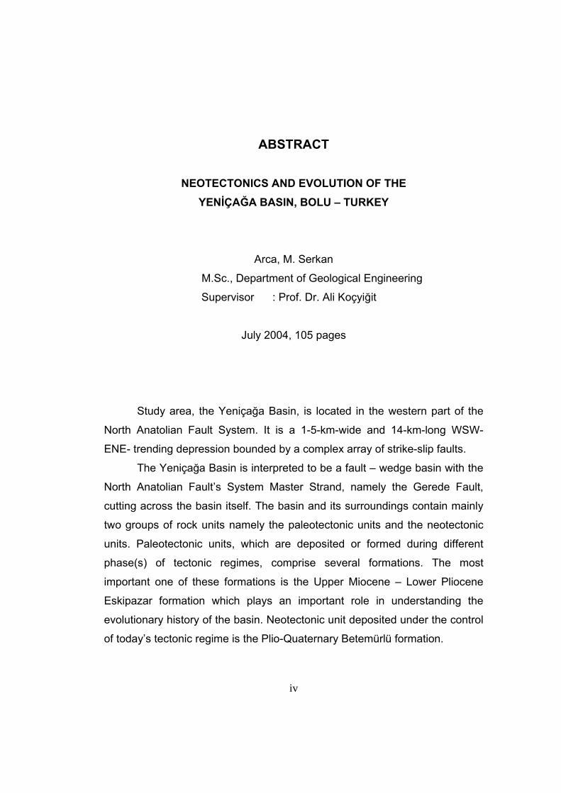
ABSTRACT
NEOTECTONICS AND EVOLUTION OF THE YENİÇAĞA BASIN, BOLU – TURKEY
Arca, M. Serkan
M.Sc., Department of Geological Engineering
Supervisor : Prof. Dr. Ali Koçyiğit
July 2004, 105 pages
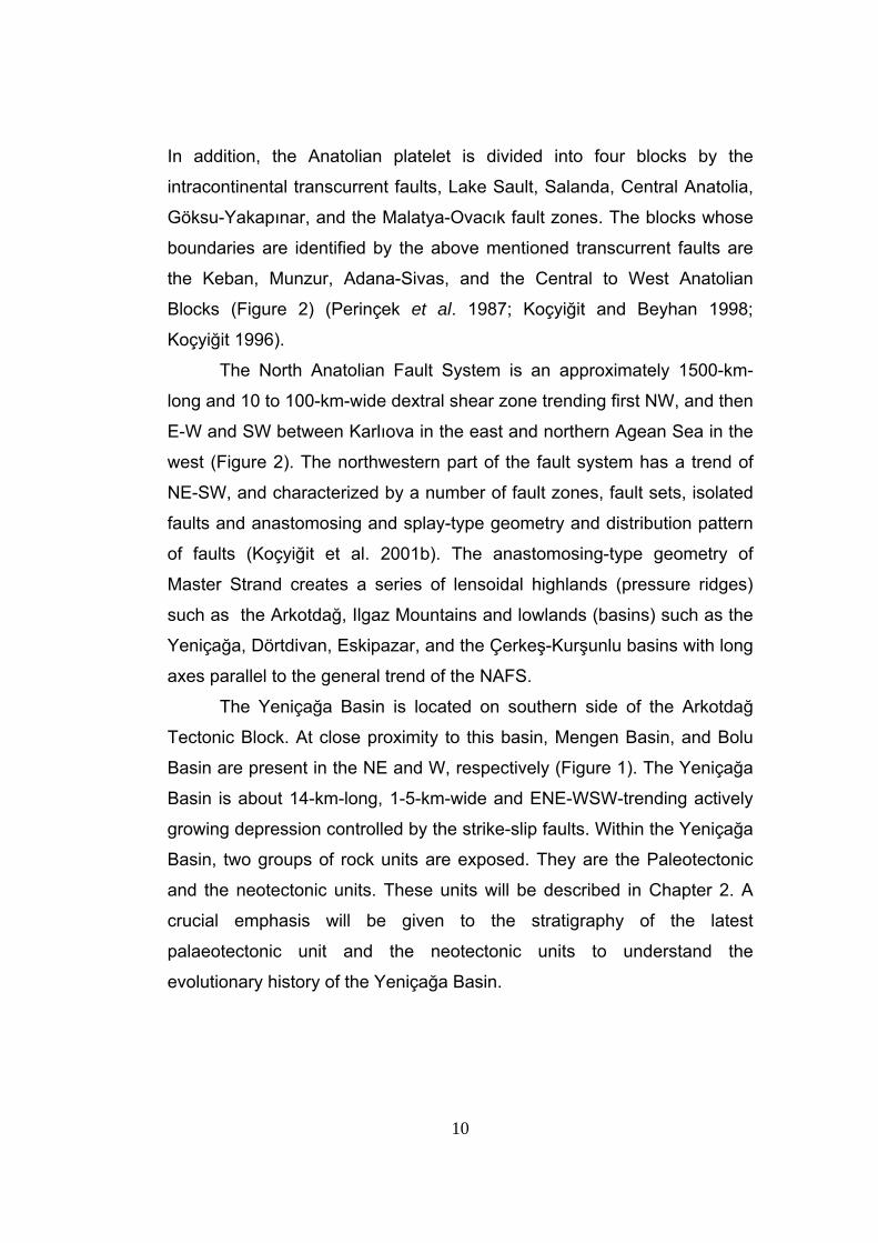
Study area, the Yeniçağa Basin, is located in the western part of the
North Anatolian Fault System. It is a 1-5-km-wide and 14-km-long WSW-
ENE- trending depression bounded by a complex array of strike-slip faults.
The Yeniçağa Basin is interpreted to be a fault – wedge basin with the
North Anatolian Fault’s System Master Strand, namely the Gerede Fault,
cutting across the basin itself. The basin and its surroundings contain mainly
two groups of rock units namely the paleotectonic units and the neotectonic
units. Paleotectonic units, which are deposited or formed during different
phase(s) of tectonic regimes, comprise several formations. The most
important one of these formations is the Upper Miocene – Lower Pliocene
Eskipazar formation which plays an important role in understanding the
evolutionary history of the basin. Neotectonic unit deposited under the control
of today’s tectonic regime is the Plio-Quaternary Betemürlü formation.
v
Betemürlü formation unconformably overlies the paleotectonic Eskipazar
formation throughout the study area and the unconformity separating these
two units corresponds to the time interval during which the paleotectonic
stress regime changed into the neotectonic stress regime. Thus, onset age of
the strike-slip neotectonic regime in the study area is Late Pliocene (~ 2,6
My).
Common basin margin-bounding faults of the Yeniçağa Basin are, the
Aşağı Kuldan fault, the Aksu fault, the İzmirli fault set, the Sarayçalı fault, the
Değirmen fault set and the Hamzabey fault set. They display well-preserved
fault scarps in places. Morphological expressions of these faults and their
geometrical relationships with the local stress regime indicate that these faults
are mainly strike-slip and oblique-slip faults.
Morphotectonic expressions of the faults exposing within the study
area indicate that these faults are active. Most of the settlements within the
study area are located on water-saturated loose basin fill nearby the active
faults. Hence, these are open to future earthquake hazards. Therefore,
structures and settlements have to be constructed on strong grounds away
from the active faults.
Keywords: neotectonics, Yeniçağa basin, North Anataolian Fault System,
stress distribution, fault-wedge basin
vi
ÖZ
YENİÇAĞA HAVZASI’NIN NEOTEKTONİĞİ VE OLUŞUMU, BOLU – TÜRKİYE
Arca, M. Serkan
Yüksek Lisans, Jeoloji Mühendisliği Bölümü
Tez Yöneticisi : Prof. Dr. Ali Koçyiğit
Temmuz 2004, 105 sayfa
Çalışma alanı, Yeniçağa Baseni, Kuzey Anadolu Fay Sistemi’nin
batısında yer almaktadır. Basen; 1-5 km genişlikte ve 14 km uzunlukta BGB-
DKD yönelimli bir çöküntü alanı olup, karmaşık düzendeki yanal atımlı faylarla
sınırlanmıştır.
Gerede Fayı olarak isimlendirilmiş Kuzey Anadolu Fay Sistemi’nin ana
kolu tarafından kesilen Yeniçağa fay kaması baseni olarak yorumlanmıştır.
Basen ve çevresi başlıca paleotektonik birimler ve neotektonik birimler olmak
üzere iki farklı kaya grubunu içerir. Tektonik rejimlerin farklı fazları sırasında
çökelmiş ya da oluşmuş paleotektonik birimler birçok formasyonu kapsarlar.
Bu formasyonlardan en önemlisi basenin evrimsel tarihini açıklamakta önemli
rol oynayan Geç Miosen – Geç Pliyosen yaşlı Eskipazar formasyonudur.
Neotektonik birimse günümüz tektonik rejimi kontrolünde çökelen Plio-
Kuvaterner yaşlı Betemürlü formasyonudur.
vii
Betemürlü formasyonu çalışma alanında paleotektonik Eskipazar
formasyonunu uyumsuzlukla örter ve bu iki birim arasındaki uyumsuzluk
paleotektonik stres rejiminin neotektonik stres rejimine dönüşmesi sırasındaki
zaman aralığına denk gelmektedir. Böylece, yanal atımlı neotektonik rejimin
çalışma alanındaki başlangıç yaşı Geç Pliyosen (~2,6 My) olarak
belirlenmiştir.
Yeniçağa Baseni’nin en önemli kenar sınırı fayları Aşağı Kuldan fayı,
Aksu fayı, İzmirli fay seti, Sarayçalı fayı, Değirmen fay seti ve Hamzabey fay
setidir. Bu faylar yer yer iyi korunmuş fay sarplıklarına sahiptirler. Fayların
morfolojik özellikleri ve yerel gerilme (sıkışma) ekseni ile olan ilişkileri, fayların
başlıca yanal atımlı ve verev atımlı olduklarını göstermektedir.
Bu fayların çalışma alanındaki morfotektonik özellikleri, fayların aktif
fay olduklarını belirtir. Çalışma alanı içindeki çoğu yerleşke aktif fayların
yakınındaki suya doygun gevşek havza dolgusu üstünde yer almaktadır.
Dolayısıyla, bu bölgeler gelecekteki depremlerde de tehlikelere açıktırlar. Bu
sebepten, yapı ve yerleşkelerin aktif faylardan uzak, sağlam zeminlere inşa
edilmesi önerilir.
Anahtar sözcükler : yenitektonik, Yeniçağa havzası, Kuzey Anadolu Fay Sistemi, yerel gerilme sistemi, fay kaması havzası

viii
To My Family
ix
ACKNOWLEDGMENTS
It is a highly rewarding experience gained by working under the
supervision of Prof.Dr. Ali Koçyiğit, to whom I am indebted for his valuable
advice, encouragement, theoretical support and criticism during the field
studies and the preparation of this thesis.
I am also indebted to TÜBİTAK, for their financial support since this
study is carried out as a part of the project entitled “ Seismicity of the Gerede-
İsmetpaşa-Mengen segment of the North Anatolian Fault System (NAFS),
Turkey” (TUBİTAK project No. YDABAG-102 Y 053).
I would like to express my gratitude to Assist.Prof.Dr.Nuretdin
Kaymakçı for his theoretical support in using “TECTOR” software developed
by Angelier (1989) and suggestions about the evolution of the Yeniçağa
Basin, Prof.Dr. Erdin Bozkurt for his support in compiling the literature review,
Assoc.Prof.Dr. Bora Rojay for his support in compiling the literature review
and suggestions about the evolution of the Yeniçağa Basin and Prof.Dr.
Vedat Toprak for his support in organizing the format of the thesis.
I would also like to special thanks to C. Berk Biryol for his valuable
encouragement and support during the 45 days field studies, and Tülin
Kaplan and Alev Güray for their help in writing the thesis and office studies.
At last but does not mean the least, I would like to express grateful
appreciation to my family for their patience and encouragement during my
studies.
x
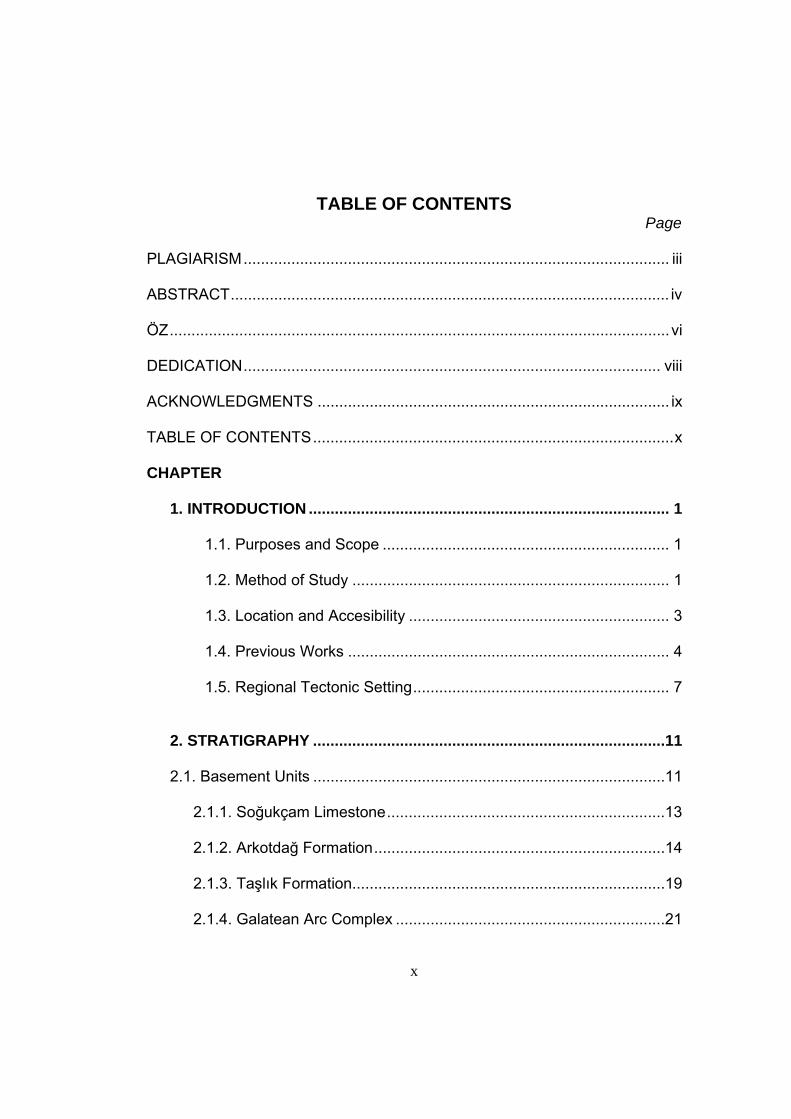
TABLE OF CONTENTS
Page PLAGIARISM.................................................................................................. iii ABSTRACT..................................................................................................... iv ÖZ...................................................................................................................vi DEDICATION................................................................................................ viii ACKNOWLEDGMENTS ................................................................................. ix TABLE OF CONTENTS...................................................................................x CHAPTER
1. INTRODUCTION ................................................................................... 1
1.1. Purposes and Scope .................................................................. 1 1.2. Method of Study ......................................................................... 1 1.3. Location and Accesibility ............................................................ 3 1.4. Previous Works .......................................................................... 4 1.5. Regional Tectonic Setting........................................................... 7
2. STRATIGRAPHY .................................................................................11 2.1. Basement Units .................................................................................11
2.1.1. Soğukçam Limestone................................................................13
2.1.2. Arkotdağ Formation...................................................................14
2.1.3. Taşlık Formation........................................................................19
2.1.4. Galatean Arc Complex ..............................................................21
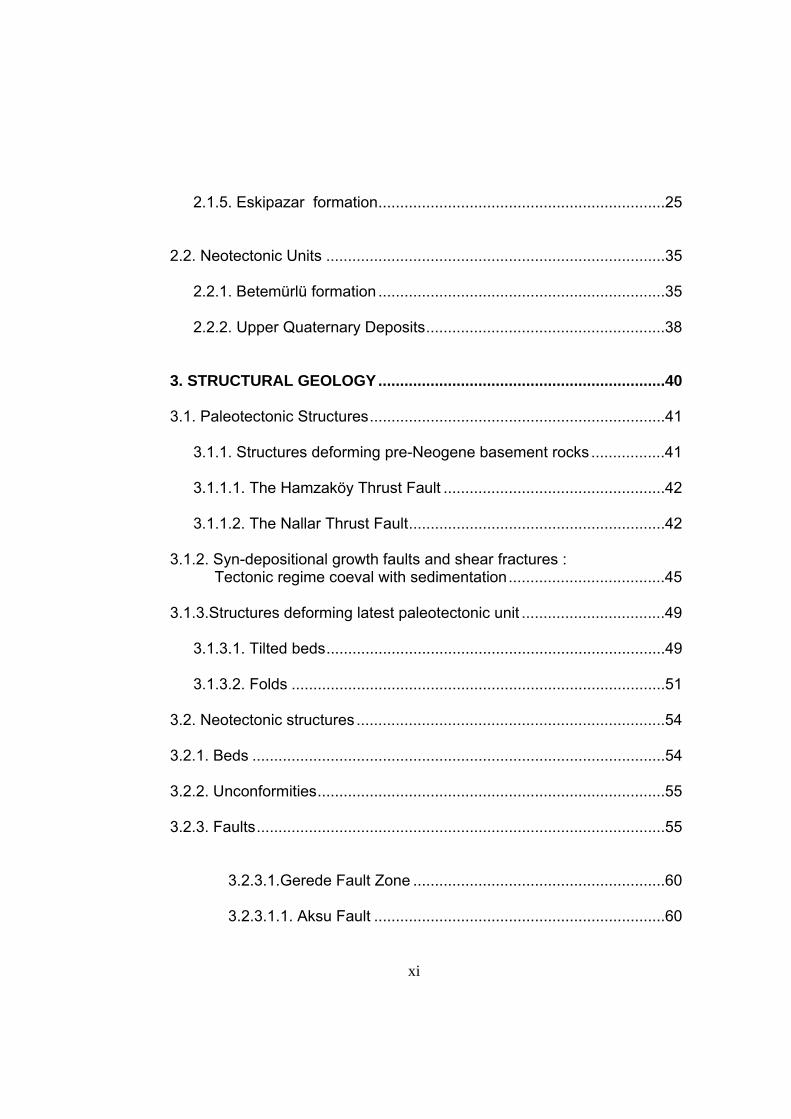
xi
2.1.5. Eskipazar formation..................................................................25
2.2. Neotectonic Units ..............................................................................35
2.2.1. Betemürlü formation ..................................................................35
2.2.2. Upper Quaternary Deposits.......................................................38
3. STRUCTURAL GEOLOGY..................................................................40 3.1. Paleotectonic Structures....................................................................41
3.1.1. Structures deforming pre-Neogene basement rocks .................41
3.1.1.1. The Hamzaköy Thrust Fault ...................................................42
3.1.1.2. The Nallar Thrust Fault...........................................................42
3.1.2. Syn-depositional growth faults and shear fractures :
Tectonic regime coeval with sedimentation....................................45
3.1.3.Structures deforming latest paleotectonic unit .................................49 3.1.3.1. Tilted beds..............................................................................49 3.1.3.2. Folds ......................................................................................51 3.2. Neotectonic structures .......................................................................54 3.2.1. Beds ...............................................................................................54 3.2.2. Unconformities................................................................................55 3.2.3. Faults..............................................................................................55
3.2.3.1.Gerede Fault Zone ..........................................................60
3.2.3.1.1. Aksu Fault ...................................................................60
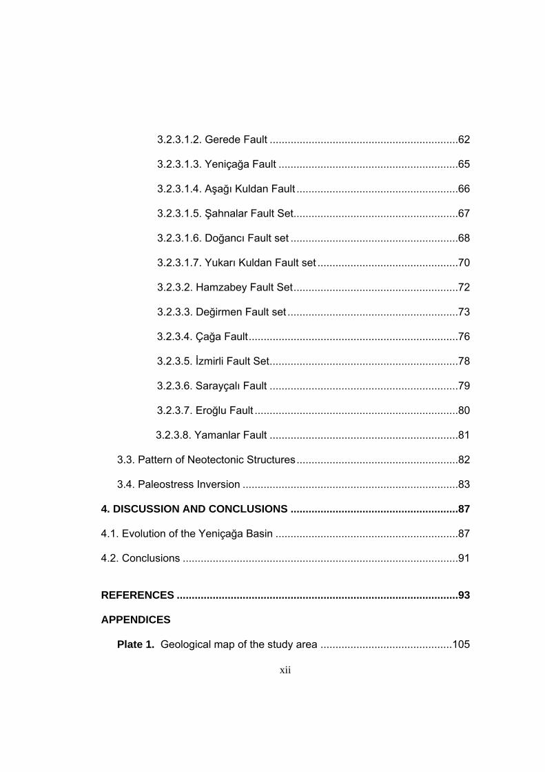
xii
3.2.3.1.2. Gerede Fault ...............................................................62
3.2.3.1.3. Yeniçağa Fault ............................................................65
3.2.3.1.4. Aşağı Kuldan Fault ......................................................66
3.2.3.1.5. Şahnalar Fault Set.......................................................67
3.2.3.1.6. Doğancı Fault set ........................................................68
3.2.3.1.7. Yukarı Kuldan Fault set ...............................................70
3.2.3.2. Hamzabey Fault Set.......................................................72
3.2.3.3. Değirmen Fault set .........................................................73
3.2.3.4. Çağa Fault......................................................................76 3.2.3.5. İzmirli Fault Set...............................................................78 3.2.3.6. Sarayçalı Fault ...............................................................79 3.2.3.7. Eroğlu Fault ....................................................................80 3.2.3.8. Yamanlar Fault ...............................................................81 3.3. Pattern of Neotectonic Structures......................................................82 3.4. Paleostress Inversion ........................................................................83
4. DISCUSSION AND CONCLUSIONS ........................................................87 4.1. Evolution of the Yeniçağa Basin .............................................................87 4.2. Conclusions ............................................................................................91
REFERENCES ..............................................................................................93 APPENDICES
Plate 1. Geological map of the study area ............................................105
xiii
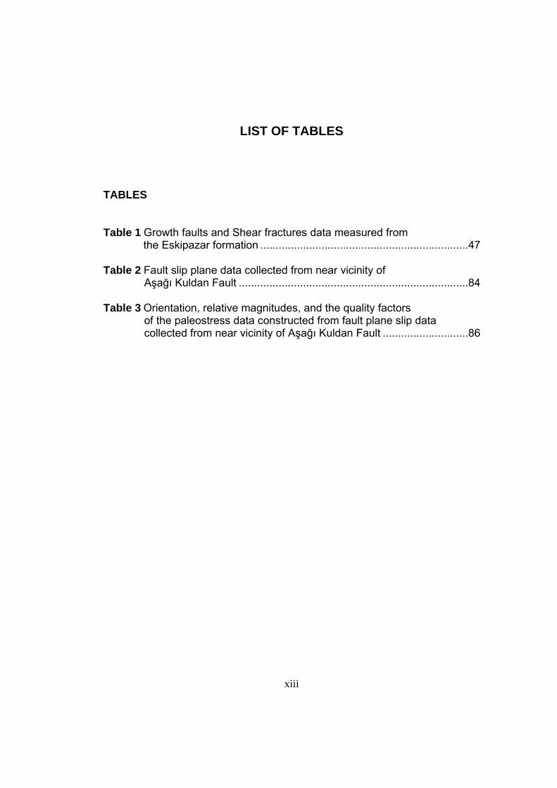
LIST OF TABLES TABLES Table 1 Growth faults and Shear fractures data measured from
the Eskipazar formation ....................................................................47 Table 2 Fault slip plane data collected from near vicinity of
Aşağı Kuldan Fault ...........................................................................84 Table 3 Orientation, relative magnitudes, and the quality factors
of the paleostress data constructed from fault plane slip data collected from near vicinity of Aşağı Kuldan Fault ............................86
xiv
LIST OF FIGURES FIGURES
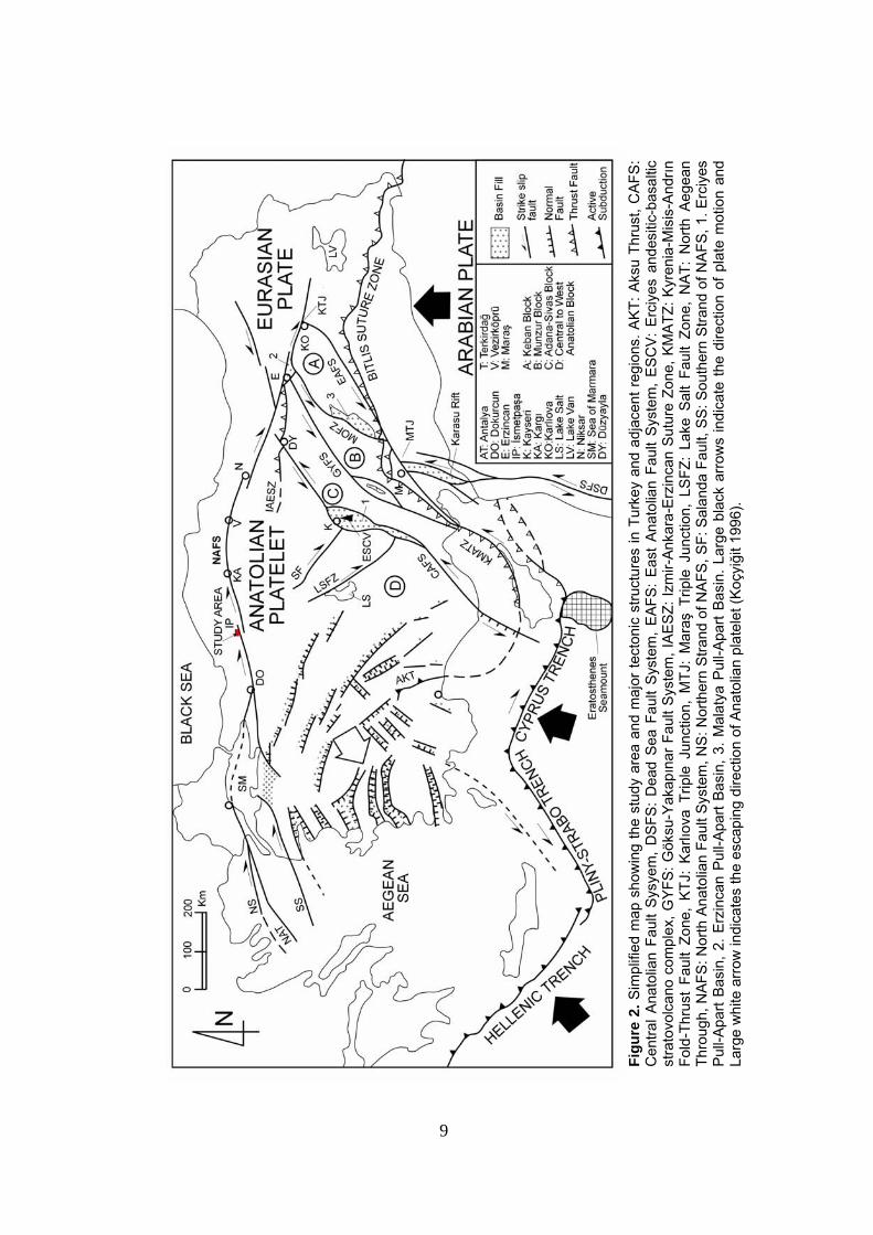
Figure 1 Simplified neotectonic map of the study area and its close vicinity
showing major neotectonic structures and basins............................ 3 Figure 2 Simplified map showing the study area and major tectonic structures in Turkey and adjacent regions ....................................... 9 Figure 3 Generalized stratigraphic columnar section showing both the paleotectonic and the neotectonic units ..............12 Figure 4 General view of the Soğukçam Limestone......................................14 Figure 5 Close-up view of the Soğukçam Limestone ....................................15 Figure 6 General view of the unconformable contact between
the “Arkotdağ Formation” and the Eskipazar formation..................16 Figure 7 General view of the highly deformed serpentinite blocks of the
“Arkotdağ Formation” ......................................................................17 Figure 8 Close-up view of the higly deformed Serpantinite blocks of the
“Arkotdağ Formation”.......................................................................17 Figure 9 Close up view of the intensely deformed
“Arkotdağ Formation” ......................................................................18 Figure 10 General view of the clastic portion of the Taşlık Formation ...........20 Figure 11 Close-up view of the clastic level of the Taşlık formation ..............20 Figure 12 Tectonic boundary relationship between the underlying
Galatean Arc Complex (KTg) and the overlying Betemürlü formation (TQb) ............................................................22
Figure 13 General view of massive agglomerates of the
Galatean Arc Complex ..................................................................23
xv
Figure 14 Close-up view of massive agglomerates and tuffaceous layer of the Galatean Arc Complex..............................24
Figure 15 General view of the layered basalts belonging to the
Galatean Arc Complex ..................................................................24 Figure 16 General view of the basal part of the Eskipazar formation ............27 Figure 17 Close-up view of the basal portion
of the Eskipazar formation.............................................................27 Figure 18 Measured section (MS2) of the basal part of the Eskipazar
formation .......................................................................................28 Figure 19 General view of the middle part of the Eskipazar formation ..........30 Figure 20 Close-up view of the middle part of the Eskipazar formation ........30 Figure 21 Measured section (MS3) of the middle part of the Eskipazar
formation .......................................................................................31 Figure 22 General view of the upper part of the Eskipazar formation............33 Figure 23 Close-up view of the upper part of the Eskipazar formation ..........33 Figure 24 Measured section (MS4) of the upper part of the Eskipazar
formation .......................................................................................34 Figure 25 Measured section (MS1) of the Plio-Quaternary Betemürlü
formation (TQb) .............................................................................36 Figure 26 Generel view of the Plio-Quaternary Betemürlü formation
(TQb) where the Plio-Quaternary terrace conglomerates and travertine deposits alternate each other ........................................37
Figure 27 Close-up view of the Plio-Quaternary
Betemürlü formation (TQb) ...........................................................38 Figure 28 General view of the Hamzaköy Thrust Fault (HTF) .......................43 Figure 29 Geological cross-sections showing geological structures,
rock units and their relationships to each other.............................44
xvi
Figure 30 Close-up view of the Syn-depositional structures in the middle portion of the latest paleotectonic unit, the Eskipazar formation.................................................................46
Figure 31 Kinematic analysis of syn-depositional growth faults
and shear fractures within the Eskipazar formation at Station 2. ...................................................................................48
Figure 32 Histogram showing predominant dip amounts of
bedding planes belonging to Eskipazar formation.........................50 Figure 33 Histogram showing predominant dip directions of
bedding planes belonging to Eskipazar formation ........................50 Figure 34 Fold map of the study area showing orientations
and positions of major fold axes and the strike-dip of bedding planes of the latest paleotectonic unit, the Eskipazar formation ................................................................52
Figure 35 Stereographic pole plots to bedding planes of
the Eskipazar formation ................................................................53 Figure 36 Neotectonic map of the Yeniçağa Basin .......................................57 Figure 37 General view of the northern and southern
margin – bounding faults of the Yeniçağa fault-wedge basin..........................................................................58
Figure 38 General view of the eastern half of the Yeniçağa
fault-wedge basin and its margin – bounding faults ......................59 Figure 39 General view of the Siyamlar section of the
Gerede Fault Zone and the Master Fault indicated by the 1944.02.01 Çerkeş-Gerede earthquake ground rupture...............................................................................61
Figure 40 General view of the western half of the Yeniçağa
fault-wedge basin and its margin – bounding faults ......................64 Figure 41 Photograph showing the right-lateral offset
(A-A’ = 7.28 m) of the line of poplar trees on the principal displacement zone (GFZMS) during the 944/02/01 Gerede-Çerkeş earthquake..........................................65
xvii
Figure 42 General view of the N-S trending fault juxtaposing the volcanics of the Galatean Arc Complex and the Soğukçam Limestone..............................................................71
Figure 43 General view of the northern margin-bounding
Değirmen fault set (DFS) and the Hamzaköy Thrust Fault (HTF).......................................................74
Figure 44 General view of the Yeniçağa fault – wedge basin
and its margin – bounding faults ...................................................77 Figure 45 Close-up view of the slickenside near vicinity of
the Aşağı Kuldan Fault..................................................................83 Figure 46 Kinematic analysis of the fault slip data taken
from near vicinity of the Aşağı Kuldan Fault ..................................85 Figure 47 General view of the Yeniçağa section (Gerede Fault Zone)
of the North Anatolian Fault System, Yeniçağa fault – wedge basin and its margin – bounding faults ..........................................89
Figure 48 Sketch block diagram illustrating the present day
configuration of the Yeniçağa Basin and the major strike-slip faults..............................................................90
1
CHAPTER 1
INTRODUCTION
1.1. Purposes and Scope
The North Anatolian Fault System is one of the world’s well-known
dextral intra-continental transform fault system that lies within the Alpine-
Himalayan belt. Numerous basins have formed within this fault system that
extends from Karlıova triple junction, where this fault system meets with
the East Anatolian Fault System, and extends along the northern
boundary of Anatolian platelet until it disappears in the Aegean sea in the
west. The basins within this fault system have different geometry and
evolutionary histories. The evolution pattern and the tectonic complexities
of these basins are governed by the westward escape of the Anatolian
platelet due to post-collisional convergence between the Arabian Plate
and the Eurasian Plate. Neotectonic basins and their infills are the best
places where style of deformation and relevant features are recorded and
well-preserved. In order to contribute to the neotectonic characteristics
and evolution pattern of the North Anatolian Fault System, neotectonic
characteristics of the NE-SW trending Yeniçağa Basin, which is located
within the western portion of North Anatolian Fault System, was analysed
under the light of new stratigraphical, structural and seismic data.
1.2. Method of Study
In order to achieve the above mentioned purpose, a research has
been carried out at three stages; (1) office work, (2) field work and (3)
laboratory to office work.
2
During the office work, available literature were collected and
reviewed at first. Later on, available borehole data were compiled and
used for assessment of Plio-Quaternary sedimentary pile.
At the stage of field work, field geological mapping is carried out at
1/25000 scale and lithological boundaries as well as related geological
structures are mapped. These features were also documented by
photography. During the field work faults were identified by their structural
and morphological properties. In addition, structural data these faults as
well as other shear planes and Planar-linear elements were measured for
the use of kinematic analysis. Apart from these, detailed stratigraphy and
deformational features of the latest paleotectonic infill of the basin
(Miocene rocks) were studied in order to make a distinction between
paleotectonic and neotectonic periods. For these purposes, the latest
paleotectonic unit and the neotectonic units are studied and analysed in
terms of measured type sections.
In the next stage of this research, which is laboratory to office work,
field data on the kinematic properties of the faults are. The data includes
dip amount, dip direction, strike and rake of the faults and similar linear
and planar properties of shear planes. These data are analysed by using a
computer a computer programme ‘Tector’ developed by Angelier (1989)
which provides stereographic plots of fault planes and orientations of
principle stress axes.
For the purpose of determining operation direction of the stress at
the time of sedimentation and at the time of deformation some
stereographic pole plots were prepared by using measured planar
attitudes of the bedding planes within the sedimentary rocks. In addition,
recent seismic events that occurred in the study area were compiled and
evaluated to find out the earthquake hazard risk in the region.
This study is prepared by using softwares “Freehand 11MX”, “Office
Work XP”, “Tector”, and “Rockware – Rockworks 2002”.
3
1.3. Location and Accessibility
The study area, the Yeniçağa Basin, is located between 40.750 –
40.820 latitudes and 31.930 – 32.120 longitudes in the southern part of the
Arkot Mountain (Figure 1). It falls in the Bolu G28-a4, G27-b3 quadrangles
and covers an area of more than 30 km2. The Yeniçağa Basin is about
NE-SW - trending depression with the maximum relief of 992 m between
the lowest basin floor and the height peak of the margin-bounding
highlands.
Figure 1. Simplified neotectonic map of the study area and its close vicinity showing major neotectonic structures and basins. HYFZ: Hendek - Yığılca Fault Zone (Northern strand of the NAFS), KKMFZ: Karadere -Kaynaşlı - Mengen Fault Zone (Central strand of the NAFS).
4
The accessibility to the study area is provided by Gerede-Bolu
highway running through the study area. Yeniçağa county is located about
12 km west of Gerede. There are also some other asphaltic, stabilized and
earthy roads cutting or joining to the main road. By using these roads both
northern and southern margins of the basin are accessible.
1.4. Previous Works
The Yeniçağa Basin and its near surroundings have been studied
by both foreign and native researchers for different purposes over the last
century and the gathered information has been published in Turkish and
foreign literatures. These works will be summarized in the following
paragraphs.
First study about the Yeniçağa Basin was carried out by Lahn
(1948). He claimed that Lake Yeniçağa and the basin surrounding it, has a
tectonic origin.
Erinç et al. (1961) carried out some studies about Çağa stream,
Çağa Lake and Çağa (Yeniçağa) depression. He reported information
about the geometry of this depression and emphasized the importance of
the major fault which is the North Anatolian Fault Master Strand that
controls the southern margin of the depression. He also briefly described
the rock units that are exposed in northern and southern parts of the North
Anatolian Fault Master Strand. They also attracted attention to the
geomorphology of the basin and its margins, and stated significance of
tectonic activity in forming morphological features surrounding the
depression. They also focused on recent and past geometry of Lake Çağa
(Yeniçağa) and defined it as a basin formed by accumulation of water at
depression center. In addition, they dealt with the Çağa stream and stated
that this stream is the one which mainly drains the basin and Lake Çağa
and flows toward North through a deep, narrow valley.
5
Tokay (1973) carried out some geological investigations along the
Gerede-Ilgaz portion of the North Anatolian Fault System by utilizing
twentyone 1/25.000 scale topographic sheets. In this study, he
investigated and reported some significant characteristics of the five
different rock units cropping-out within the study area. Besides these, he
also identified six different and major faults and/or fault sets exposed
within the study area or and its vicinity.
He documented some important information about the characteristics,
geometrical relations and properties of these faults as well as their recent
or past activities. The faults are namely Ulusu Fault, Gerede, Çerkeş,
Dikmen, Kızılibrik, Yılanlı faults. He explained that these faults are
comprising the Gerede-Ilgaz portion of the North Anatolian Fault System.
He noted that the Ulusu Fault is the most active fault of the system along
which the recent seismic activity has taken place and which can be
identified as the Master Strand of the North Anatolian Fault System.
According to him, the margin-structures within the Gerede-Ilgaz portion of
the fault system however, other faults such as the Çerkeş, Dikmen,
Kızılibrik and Yılanlı are the ones determining both northern and southern
walls of the zone of deformation controlling the morphology. He also dealt
with the seismotectonics of the region and seismicity along the fault zone.
In conclusion, he evaluated the previous models on origin of the NAFS
and discussed their reliability based on his own observations.
Şengör et al. (1985) identified Yeniçağa Basin as a tectonically
controlled depression and claimed that this basin is located at the point of
bifurcation of North Anatolian Fault System, and stated that this
depression may be an extensional fault wedge basin.
Öztürk et al. (1984, 1985) identified the Yeniçağa Basin as a
tectonically controlled depression and claimed that this basin is located at
the point of bifurcation of the North Anatolian Fault System.
6
They identified the deformational structures under two categories which
are the paleotectonic structures and the neotectonic structures. Besides,
they also identified the rocks exposed within their study area as
paleotectonic and neotectonic units. They summarized the major
extensional and compressional phases prevailed in this region during the
paleotectonic and neotectonic periods. Several fold axis orientations in
each rock unit pointing out the time – dependent change in the
compression direction acting on the region was also documented.
They named mainly twelve faults of neotectonic origin, namely the
Hacigüzel, Kayserler, İslamlar, Çukurviran, Çakmaklar, Karamanlar,
İkizler, Dereceviran, Musalar, Nallar, Rüzgarlar and the Akçaalan faults.
Based on field observations, they stated that the age of the North
Anatolian Fault System is of post Late Miocene.
Serdar and Uğur (1990) studied the Mengen-Bolu-Abant portion of
the North Anatolian Fault System. They reported the detailed description
of rock units exposed within this area. They also stated the structural
geology of this region and gave some information mainly on folds and
faults. They have also explained the geological evolution of the area
based on their observations and gave information about the petroleum
potential of the area.
Şaroğlu et al. (1995) mapped the geology of the area located
between Yeniçağa and Eskipazar at a scale of 1/25.000. They studied
several rock units within the study area and subdivided these rock units
into two categories based on their position with respect to the North
Anatolian Fault System. These categories are, the units on the northern
block and those on the southern block of the North Anatolian Fault
System. They identified the structures exposed within the study are in the
same manner, as the structures belonging to the northern part of the North
Anatolian Fault and those on the southern block of the North Anatolian
Fault System.
7
In addition to this, they also focused on the geomorphology and the
economic geology of the region. Based on their analysis and observations,
the North Anatolian Fault System is Late – Pliocene in age.
Yiğitbaş and Elmas (1997, 2001) studied the Bolu-Eskipazar-
Devrek-Çaycuma region and they divided this region based on the
stratigraphical and tectonic characteristics of the rock units exposing within
the belt into mainly seven subareas, namely the Sakarya Continent, the
Bolu-Eskipazar Zone, the Karabük Basin, the Sünnice High, the Ulus
Basin, the Devrek – Çaycuma lowland and the western Blacksea Coastal
Mountain chains.
Within the Bolu-Eskipazar Zone, they identified mainly eight rock units, as
the Ağalar metamorphic group, the Bakacak Metamorphics, the Ulumescit
Group, the Yayla Granite, the Gölcük Group, the Apalar Group, the
Neogene Units, and the Quaternary Units. Based on their observations,
the Neogene deposits cover all other units with an angular unconformity
and they are composed mainly of fluvio-lacustrine deposits. In addition to
these, they identified Quaternary units as alluvium, slope scree and the
fault-parallel exposing travertine deposits. From the tectonic point of view,
they identified the WSW-ENE- trending Bolu-Eskipazar Zone to be a
narrow zone confined by the Sakarya continent to the south and the
Sünnice high to the north.
1.5. Regional Tectonic Setting
Turkey is located in the Mediterranean-Himalaya Seismic zone. The
structures characterizing this belt are also responsible for high seismicity.
Among these structures are mainly the North Anatolian, East Anatolian,
and the Dead Sea fault systems and the Hellenic-west Cyprus arc (Figure
2).
8
The Dextral North Anatolian intracontinental transform fault system formes
the contact between the Eurasian Plate in the north and the Anatolian
platelet in the south. This fault system is conjugate to the sinistral East
Anatolian Intracontinental transform fault system and they are Pliocene in
age. They may have formed as a natural response to the post-collisional
north-south directed convergence between the Arabian Plate and the
Eurasian Plate (Koçyiğit et al., 2001a). At eastern Anatolia, this
convergence produces N-S orientated compression.
Today, the westward escaping Anatolian platelet moves onto the
oceanic lithosphere of the eastern-Mediterranean Sea, and the African
Plate has been subducting northwards beneath the Anatolian platelet with
a rate of 35 mm/yr (McKenzie 1972 ; Le Pichon and Angelier 1979 ;
Meulenkamp et al. 1988 ; Kahle et al. 1998) along the active subduction
zone of Hellenic – west Cyprus arc. This subduction results in a roll-back
geometry (Le Pichon and Angelier 1979; Koçyiğit 1984; Royden 1993)
which can be considered to be the reason of nearly N-S extension and
formation of nearly E-W-, NW-, NE- trending horst-graben system in
western Anatolia. The westward tectonic escape of Anatolian platelet
along East Anatolian intracontinental transform fault and the North
Anatolian intracontinental transform fault continues since the Late
Pliocene, therefore, Late Pliocene is accepted to be the initiation time of
neotectonic period (2.6 Ma) (Tokay 1973 ; Hempton 1987; Şaroğlu 1988;
Koçyiğit and Beyhan 1998; Koçyiğit et al. 2001; Bozkurt 2001). Average
rates of slip along the NAFS and EAFS are estimated at 10 mm/yr and 6
mm/yr, respectively, based on field observations (Tokay 1973; Tatar 1978;
Barka and Hancock 1984; Barka and Gülen 1988; Şaroğlu 1988; Koçyiğit
1988, 1989, 1990) while they appear to be 26 mm/yr and 13 mm/yr
respectively, based on Global Positioning System (GPS) and
seismological data (Mckenzie 1972; Canıtez 1973; North 1974; Reilinger
et al. 1997, Stein et al. 1997; Kahle et al. 1998, 2000; McClusky et al.,
2000).
9
Fi
gure
2. S
impl
ified
map
sho
win
g th
e st
udy
area
and
maj
or te
cton
ic s
truct
ures
in T
urke
y an
d ad
jace
nt r
egio
ns. A
KT:
Aks
u Th
rust
, CA
FS:
Cen
tral A
nato
lian
Faul
t Sy
syem
, D
SFS
: D
ead
Sea
Fau
lt S
yste
m,
EA
FS:
Eas
t A
nato
lian
Faul
t S
yste
m,
ES
CV
: E
rciy
es a
ndes
itic-
basa
ltic
stra
tovo
lcan
o co
mpl
ex, G
YFS:
Gök
su-Y
akapın
ar F
ault
Sys
tem
, IA
ES
Z: Iz
mir-
Anka
ra-E
rzin
can
Sut
ure
Zone
, KM
ATZ
: Kyr
enia
-Mis
is-A
ndrın
Fo
ld-T
hrus
t Fa
ult
Zone
, K
TJ:
Kar
lıova
Trip
le J
unct
ion,
MTJ
: M
araş
Trip
le J
unct
ion,
LS
FZ:
Lake
Sal
t Fa
ult
Zone
, N
AT:
Nor
th A
egea
n Th
roug
h, N
AFS
: Nor
th A
nato
lian
Faul
t Sys
tem
, NS
: Nor
ther
n S
trand
of N
AFS
, SF:
Sal
anda
Fau
lt, S
S: S
outh
ern
Stra
nd o
f NA
FS, 1
. Erc
iyes
P
ull-A
part
Bas
in, 2
. Erz
inca
n P
ull-A
part
Bas
in, 3
. Mal
atya
Pul
l-Apa
rt B
asin
. Lar
ge b
lack
arr
ows
indi
cate
the
dire
ctio
n of
pla
te m
otio
n an
d La
rge
whi
te a
rrow
indi
cate
s th
e es
capi
ng d
irect
ion
of A
nato
lian
plat
elet
(Koç
yiği
t 199
6).
9
10
In addition, the Anatolian platelet is divided into four blocks by the
intracontinental transcurrent faults, Lake Sault, Salanda, Central Anatolia,
Göksu-Yakapınar, and the Malatya-Ovacık fault zones. The blocks whose
boundaries are identified by the above mentioned transcurrent faults are
the Keban, Munzur, Adana-Sivas, and the Central to West Anatolian
Blocks (Figure 2) (Perinçek et al. 1987; Koçyiğit and Beyhan 1998;
Koçyiğit 1996).
The North Anatolian Fault System is an approximately 1500-km-
long and 10 to 100-km-wide dextral shear zone trending first NW, and then
E-W and SW between Karlıova in the east and northern Agean Sea in the
west (Figure 2). The northwestern part of the fault system has a trend of
NE-SW, and characterized by a number of fault zones, fault sets, isolated
faults and anastomosing and splay-type geometry and distribution pattern
of faults (Koçyiğit et al. 2001b). The anastomosing-type geometry of
Master Strand creates a series of lensoidal highlands (pressure ridges)
such as the Arkotdağ, Ilgaz Mountains and lowlands (basins) such as the
Yeniçağa, Dörtdivan, Eskipazar, and the Çerkeş-Kurşunlu basins with long
axes parallel to the general trend of the NAFS.
The Yeniçağa Basin is located on southern side of the Arkotdağ
Tectonic Block. At close proximity to this basin, Mengen Basin, and Bolu
Basin are present in the NE and W, respectively (Figure 1). The Yeniçağa
Basin is about 14-km-long, 1-5-km-wide and ENE-WSW-trending actively
growing depression controlled by the strike-slip faults. Within the Yeniçağa
Basin, two groups of rock units are exposed. They are the Paleotectonic
and the neotectonic units. These units will be described in Chapter 2. A
crucial emphasis will be given to the stratigraphy of the latest
palaeotectonic unit and the neotectonic units to understand the
evolutionary history of the Yeniçağa Basin.
11
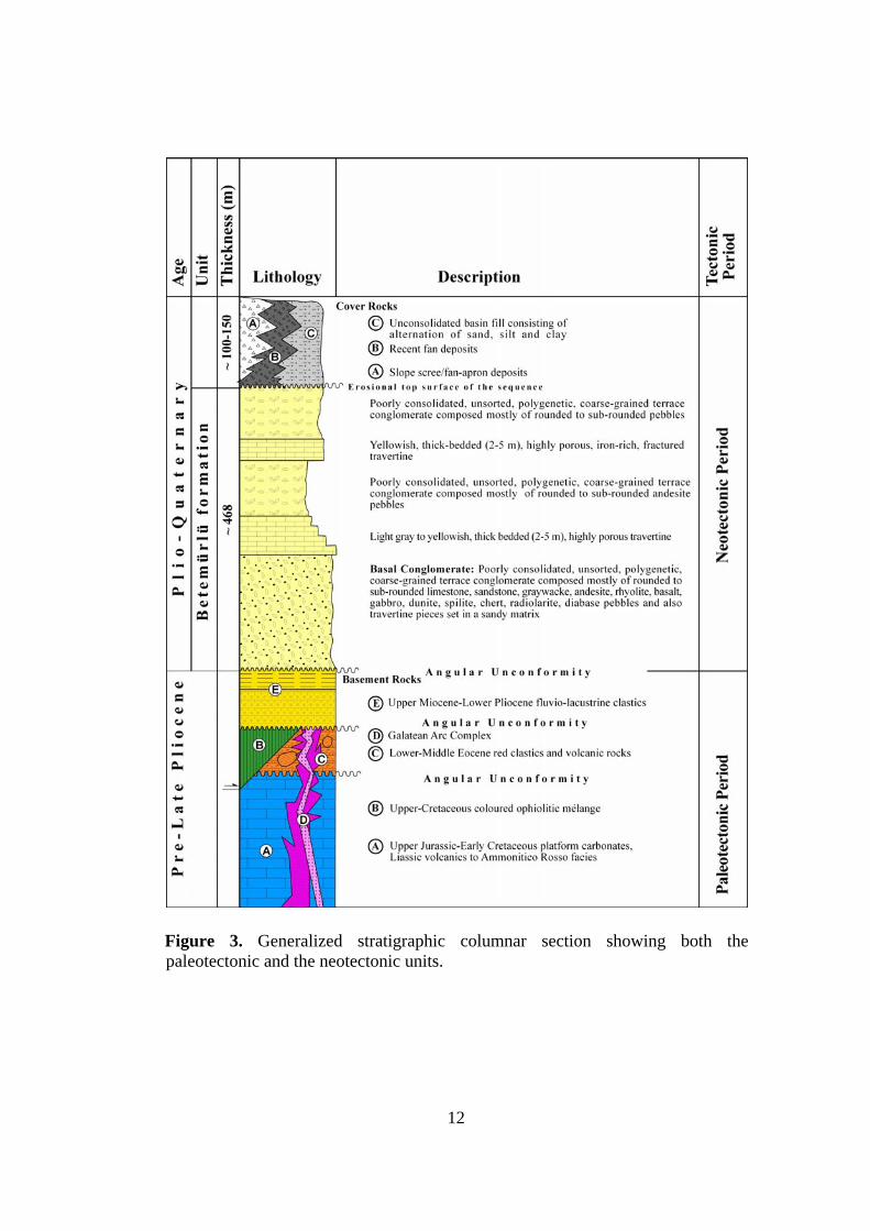
CHAPTER 2
STRATIGRAPHY
The rock units exposed in the study area are divided into two
groups. the basement and cover units. The neotectonic unit comprise the
cover units, whereas older rocks unconformably beneath the neotectonic
units are categorized into basement units. The distribution of units
exposed within the study area are plotted on a geological map at 1/25.000
scale, and the generalized stratigraphic columnar section of the study area
is given in Plate 1 and Figure 3, respectively. The basement rocks are
outside of this work scope; therefore they will not be described in detail.
But detailed descriptions of the youngest paleotectonic unit and the
neotectonic units are given below.
2.1. Basement Units
The basement units comprise Jurassic–Cretaceous dolomitic
limestones (Soğukçam Limestone), the Upper Cretaceous ophiolitic
mélange (“the Arkotdağ Formation”), the Lower–Middle Eocene red-
clastics (Taşlık Formation) which laterally grades into Lower – Middle
Eocene volcanics of the Galatean Arc Complex, the Upper Miocene–
Lower Pliocene fluvial clastics (Eskipazar formation) which comprises the
youngest paleotectonic unit in the study area.
12
Figure 3. Generalized stratigraphic columnar section showing both the paleotectonic and the neotectonic units.
13
2.1.1. Soğukçam Limestone (JKs)
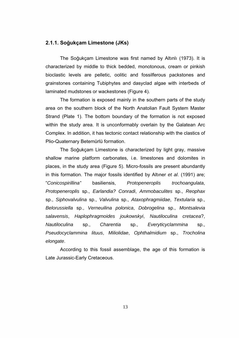
The Soğukçam Limestone was first named by Altınlı (1973). It is
characterized by middle to thick bedded, monotonous, cream or pinkish
bioclastic levels are pelletic, oolitic and fossilferous packstones and
grainstones containing Tubiphytes and dasyclad algae with interbeds of
laminated mudstones or wackestones (Figure 4).
The formation is exposed mainly in the southern parts of the study
area on the southern block of the North Anatolian Fault System Master
Strand (Plate 1). The bottom boundary of the formation is not exposed
within the study area. It is unconformably overlain by the Galatean Arc
Complex. In addition, it has tectonic contact relationship with the clastics of
Plio-Quaternary Betemürlü formation.
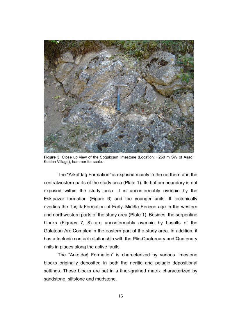
The Soğukçam Limestone is characterized by light gray, massive
shallow marine platform carbonates, i.e. limestones and dolomites in
places, in the study area (Figure 5). Micro-fossils are present abundantly
in this formation. The major fossils identified by Altıner et al. (1991) are;
“Conicospirillina” basiliensis, Protopeneroplis trochoangulata,
Protopeneroplis sp., Earlandia? Conradi, Ammobaculites sp., Reophax
sp., Siphovalvulina sp., Valvulina sp., Ataxophragmiidae, Textularia sp.,
Belorussiella sp., Verneuilina polonica, Dobrogelina sp., Montsalevia
salavensis, Haplophragmoides joukowskyi, Nautiloculina cretacea?,
Nautiloculina sp., Charentia sp., Everyticyclammina sp.,
Pseudocyclammina lituus, Miliolidae, Ophthalmidium sp., Trocholina
elongate.
According to this fossil assemblage, the age of this formation is
Late Jurassic-Early Cretaceous.
14
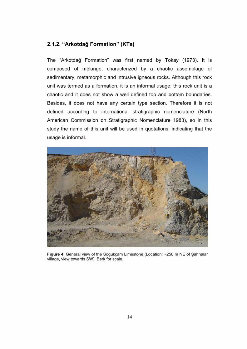
2.1.2. “Arkotdağ Formation” (KTa)
The “Arkotdağ Formation” was first named by Tokay (1973). It is
composed of mélange, characterized by a chaotic assemblage of
sedimentary, metamorphic and intrusive igneous rocks. Although this rock
unit was termed as a formation, it is an informal usage; this rock unit is a
chaotic and it does not show a well defined top and bottom boundaries.
Besides, it does not have any certain type section. Therefore it is not
defined according to international stratigraphic nomenclature (North
American Commission on Stratigraphic Nomenclature 1983), so in this
study the name of this unit will be used in quotations, indicating that the
usage is informal.
Figure 4. General view of the Soğukçam Limestone (Location: ~250 m NE of Şahnalar village, view towards SW), Berk for scale.
15
Figure 5. Close up view of the Soğukçam limestone (Location: ~250 m SW of Aşağı Kuldan Village), hammer for scale.
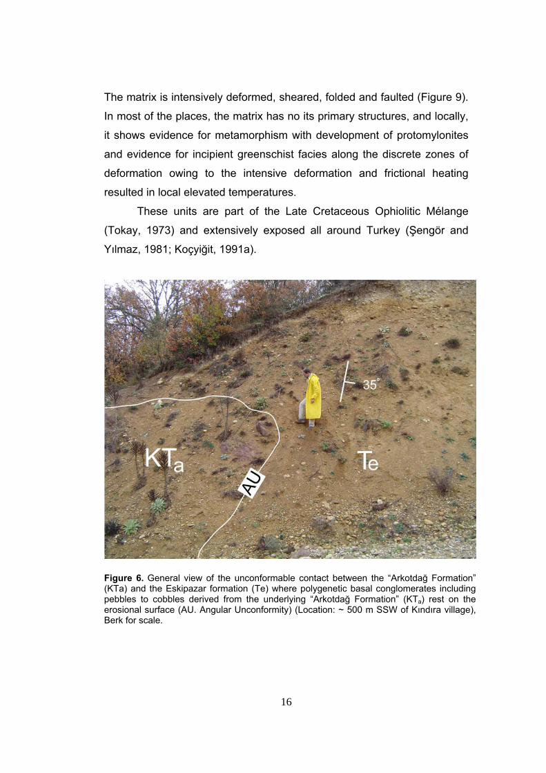
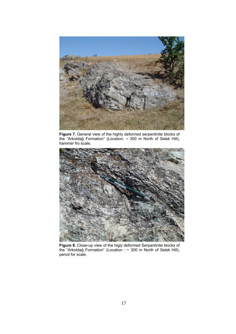
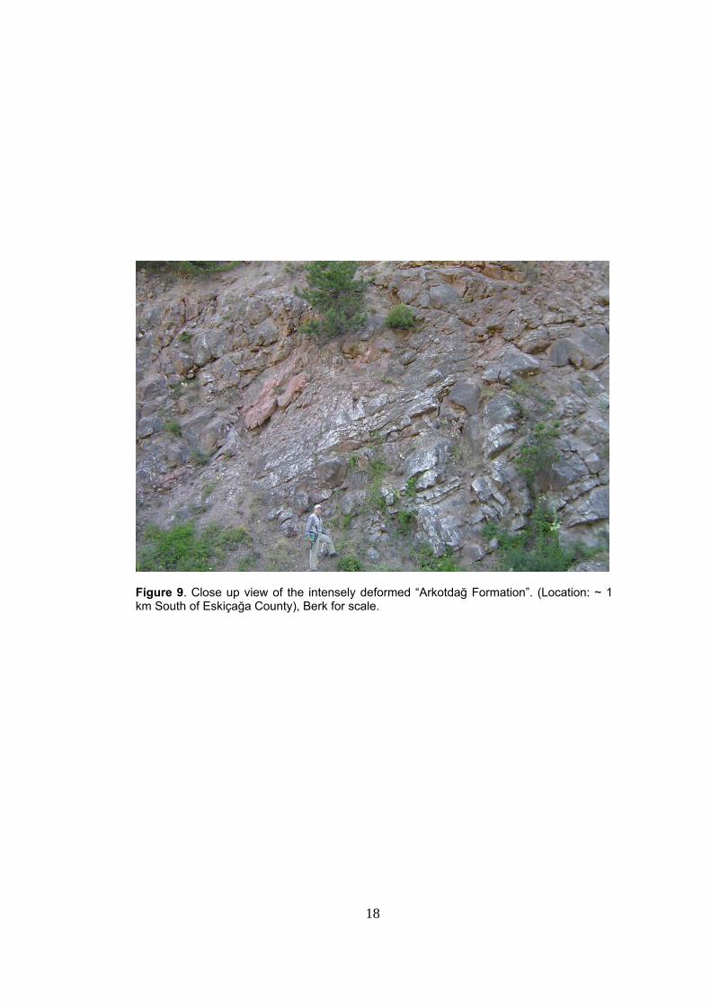
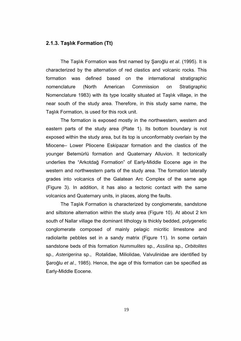
The “Arkotdağ Formation” is exposed mainly in the northern and the
centralwestern parts of the study area (Plate 1). Its bottom boundary is not
exposed within the study area. It is unconformably overlain by the
Eskipazar formation (Figure 6) and the younger units. It tectonically
overlies the Taşlık Formation of Early–Middle Eocene age in the western
and northwestern parts of the study area (Plate 1). Besides, the serpentine
blocks (Figures 7, 8) are unconformably overlain by basalts of the
Galatean Arc Complex in the eastern part of the study area. In addition, it
has a tectonic contact relationship with the Plio-Quaternary and Quatenary
units in places along the active faults.
The “Arkotdağ Formation” is characterized by various limestone
blocks originally deposited in both the neritic and pelagic depositional
settings. These blocks are set in a finer-grained matrix characterized by
sandstone, siltstone and mudstone.
16
The matrix is intensively deformed, sheared, folded and faulted (Figure 9).
In most of the places, the matrix has no its primary structures, and locally,
it shows evidence for metamorphism with development of protomylonites
and evidence for incipient greenschist facies along the discrete zones of
deformation owing to the intensive deformation and frictional heating
resulted in local elevated temperatures.
These units are part of the Late Cretaceous Ophiolitic Mélange
(Tokay, 1973) and extensively exposed all around Turkey (Şengör and
Yılmaz, 1981; Koçyiğit, 1991a).
Figure 6. General view of the unconformable contact between the “Arkotdağ Formation” (KTa) and the Eskipazar formation (Te) where polygenetic basal conglomerates including pebbles to cobbles derived from the underlying “Arkotdağ Formation” (KTa) rest on the erosional surface (AU. Angular Unconformity) (Location: ~ 500 m SSW of Kındıra village), Berk for scale.
17
Figure 7. General view of the highly deformed serpentinite blocks of the “Arkotdağ Formation” (Location: ~ 300 m North of Selek Hill), hammer fro scale.
Figure 8. Close-up view of the higly deformed Serpantinite blocks of the “Arkotdağ Formation” (Location : ~ 300 m North of Selek Hill), pencil for scale.
18
Figure 9. Close up view of the intensely deformed “Arkotdağ Formation”. (Location: ~ 1 km South of Eskiçağa County), Berk for scale.
19
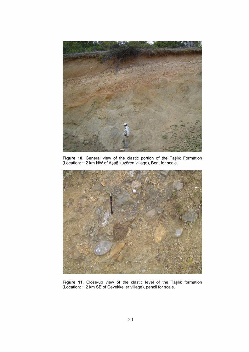
2.1.3. Taşlık Formation (Tt)
The Taşlık Formation was first named by Şaroğlu et al. (1995). It is
characterized by the alternation of red clastics and volcanic rocks. This
formation was defined based on the international stratigraphic
nomenclature (North American Commission on Stratigraphic
Nomenclature 1983) with its type locality situated at Taşlık village, in the
near south of the study area. Therefore, in this study same name, the
Taşlık Formation, is used for this rock unit.
The formation is exposed mostly in the northwestern, western and
eastern parts of the study area (Plate 1). Its bottom boundary is not
exposed within the study area, but its top is unconformably overlain by the
Miocene– Lower Pliocene Eskipazar formation and the clastics of the
younger Betemürlü formation and Quaternary Alluvion. It tectonically
underlies the “Arkotdağ Formation” of Early-Middle Eocene age in the
western and northwestern parts of the study area. The formation laterally
grades into volcanics of the Galatean Arc Complex of the same age
(Figure 3). In addition, it has also a tectonic contact with the same
volcanics and Quaternary units, in places, along the faults.
The Taşlık Formation is characterized by conglomerate, sandstone
and siltstone alternation within the study area (Figure 10). At about 2 km
south of Nallar village the dominant lithology is thickly bedded, polygenetic
conglomerate composed of mainly pelagic micritic limestone and
radiolarite pebbles set in a sandy matrix (Figure 11). In some certain
sandstone beds of this formation Nummulites sp., Assilina sp., Orbitolites
sp., Asterigerina sp., Rotalidae, Miliolidae, Valvulinidae are identified by
Şaroğlu et al., 1985). Hence, the age of this formation can be specified as
Early-Middle Eocene.
20
Figure 10. General view of the clastic portion of the Taşlık Formation (Location: ~ 2 km NW of Aşağıkuzören village), Berk for scale.
Figure 11. Close-up view of the clastic level of the Taşlık formation (Location: ~ 2 km SE of Cevekkeller village), pencil for scale.
21
2.1.4. Galatean Arc Complex (KTg)
The sequence of volcanic rocks exposing in the Bolu – Ankara –
region between İzmir – Ankara – Erzincan Suture Zone (IAESZ) in the
south and the North Anatolian Fault System in the north have long been
mapped and studied by many researchers (Stchepinsky and Lahn 1941;
Erol 1951, 1954, 1955; Akyol 1969; Fourquin et al. 1970; Öngür 1977; Ach
1982; Akyürek et al. 1984; Kazancı and Gökten 1988; Tankut et al. 1990;
Türkecan et al. 1991; Koçyiğit 1991a, b; Keller et al. 1992; Gökten et al.
1996; Toprak et al. 1996; Wilson et al.1997). Based on geological
mapping at 1/100.000 scale, Erol (1951, 1954, 1955) used various terms,
such as the ‘Tertiary Volcanic Series’, ‘Köroğlu Volcanic Series’, ‘Köroğlu
Complex’ to describe this sequence of volcanic rocks. Besides, Tankut et
al. (1990) studied the geochemistry of some spot samples collected from
the southeastern part of the outcrops of this sequence and renamed these
rocks as the ‘Köroğlu (Galatia) Volcanic Complex’. However, Koçyiğit
(1991a) and Koçyiğit et al. (2003a) carried out some detailed studies in the
southern parts of this sequence. They determined the top and bottom of
the sequence, measured several stratigraphical sections to define and
describe these rock units and pointed out the tectonic significance of both
the presence and spatial distribution of these rocks. Koçyiğit et al. (2003a)
pointed out that these rocks have formed under the multi-phase magmatic
arc evolution, and then named this sequence of volcanic rocks as the
Galetean Arc. As this nomenclature provides a broader and
stratigraphically better stated description of the unit, in this study, this
volcano – sedimentary rock sequence is referred to as Galatean Arc
Complex (GAC).
The part of the Galatean Arc Complex is exposed mainly in the
southern part of the study area (Plate 1).
22
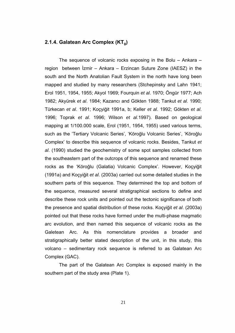
It unconformably overlies the Soğukçam Limestone, but it is
unconformably overlain by the Betemürlü formation in the southern parts
of the study area. The formation laterally grades into Lower-Middle Eocene
Taşlık Formation (Figure 3). In addition, it has a tectonic contact
relationship with the Quaternary units, in places, along the active faults in
the southern parts of the study area (Figure 12).
Figure 12. Tectonic boundary relationship between the underlying Galatean Arc Complex (KTg) and the overlying Betemürlü formation (TQb) (Location: ~100 m SE of Aşağıkuldan village, view to NW).
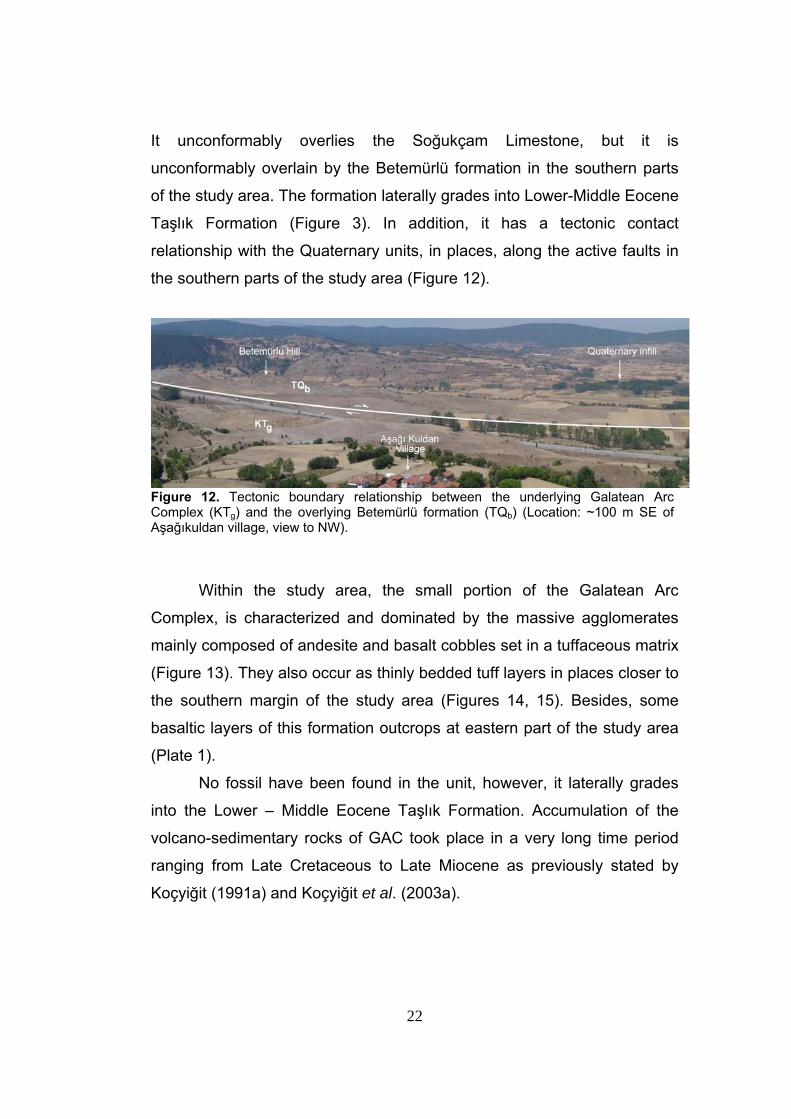
Within the study area, the small portion of the Galatean Arc
Complex, is characterized and dominated by the massive agglomerates
mainly composed of andesite and basalt cobbles set in a tuffaceous matrix
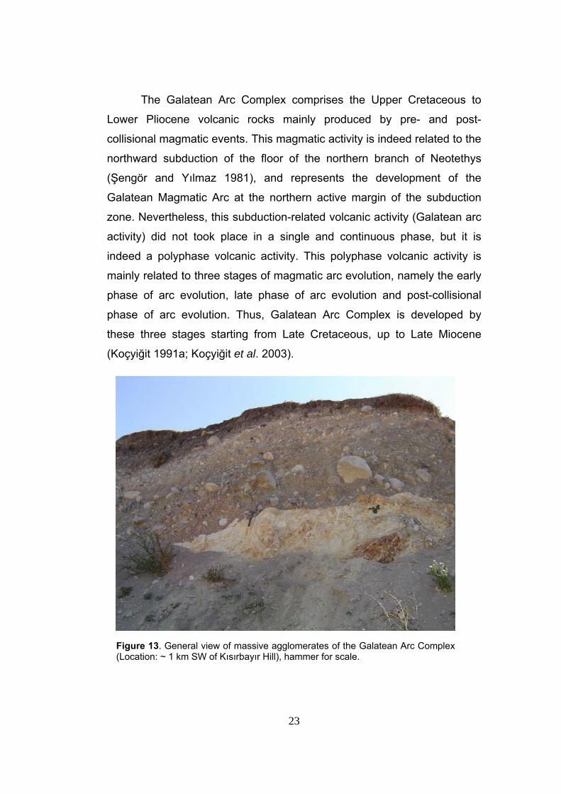
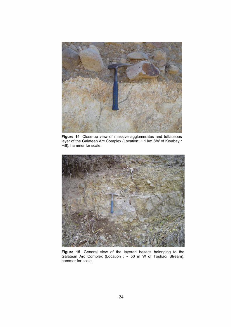
(Figure 13). They also occur as thinly bedded tuff layers in places closer to
the southern margin of the study area (Figures 14, 15). Besides, some
basaltic layers of this formation outcrops at eastern part of the study area
(Plate 1).
No fossil have been found in the unit, however, it laterally grades
into the Lower – Middle Eocene Taşlık Formation. Accumulation of the
volcano-sedimentary rocks of GAC took place in a very long time period
ranging from Late Cretaceous to Late Miocene as previously stated by
Koçyiğit (1991a) and Koçyiğit et al. (2003a).
23
The Galatean Arc Complex comprises the Upper Cretaceous to
Lower Pliocene volcanic rocks mainly produced by pre- and post-
collisional magmatic events. This magmatic activity is indeed related to the
northward subduction of the floor of the northern branch of Neotethys
(Şengör and Yılmaz 1981), and represents the development of the
Galatean Magmatic Arc at the northern active margin of the subduction
zone. Nevertheless, this subduction-related volcanic activity (Galatean arc
activity) did not took place in a single and continuous phase, but it is
indeed a polyphase volcanic activity. This polyphase volcanic activity is
mainly related to three stages of magmatic arc evolution, namely the early
phase of arc evolution, late phase of arc evolution and post-collisional
phase of arc evolution. Thus, Galatean Arc Complex is developed by
these three stages starting from Late Cretaceous, up to Late Miocene
(Koçyiğit 1991a; Koçyiğit et al. 2003).
Figure 13. General view of massive agglomerates of the Galatean Arc Complex (Location: ~ 1 km SW of Kısırbayır Hill), hammer for scale.
24
Figure 14. Close-up view of massive agglomerates and tuffaceous layer of the Galatean Arc Complex (Location: ~ 1 km SW of Kısırbayır Hill), hammer for scale.
Figure 15. General view of the layered basalts belonging to the Galatean Arc Complex (Location : ~ 50 m W of Toshacı Stream), hammer for scale.
25
2.1.5. Eskipazar formation (Te)
The Eskipazar formation is named for the first time in this study. It is
characterized by fluvio-lacustrine red clastics. This formation was
previously named as Pazarbaşı formation by Şaroğlu et al. (1995).
However, the “Pazarbaşı Formation” was poorly defined in their study,
without presenting any type or measured sections. Therefore, in this study
the unit is redefined by presenting type and measured sections in
accordance with the international stratigraphic nomenclature (North
American Commission on Stratigraphic Nomenclature 1983).
The Eskipazar formation is extensively exposed in the northwestern
part of the study area (Plate 1). It unconformably overlies the “Arkotdağ
Formation” and Taşlık Formation in the northwestern part of the study area
(Figure 6). The Eskipazar formation is unconformably overlain by the
clastics of the Plio-Quaternary Betemürlü formation in the northwestern
parts of the study area. In addition, it has also tectonic contact relationship
with the Quaternary units along the active faults.
The Eskipazar formation is the youngest paleotectonic unit exposed
in the study area and thus it has an important role in understanding the
evolutionary history of the Yeniçağa Basin. For this reason the Eskipazar
formation will be explained here in more detail.
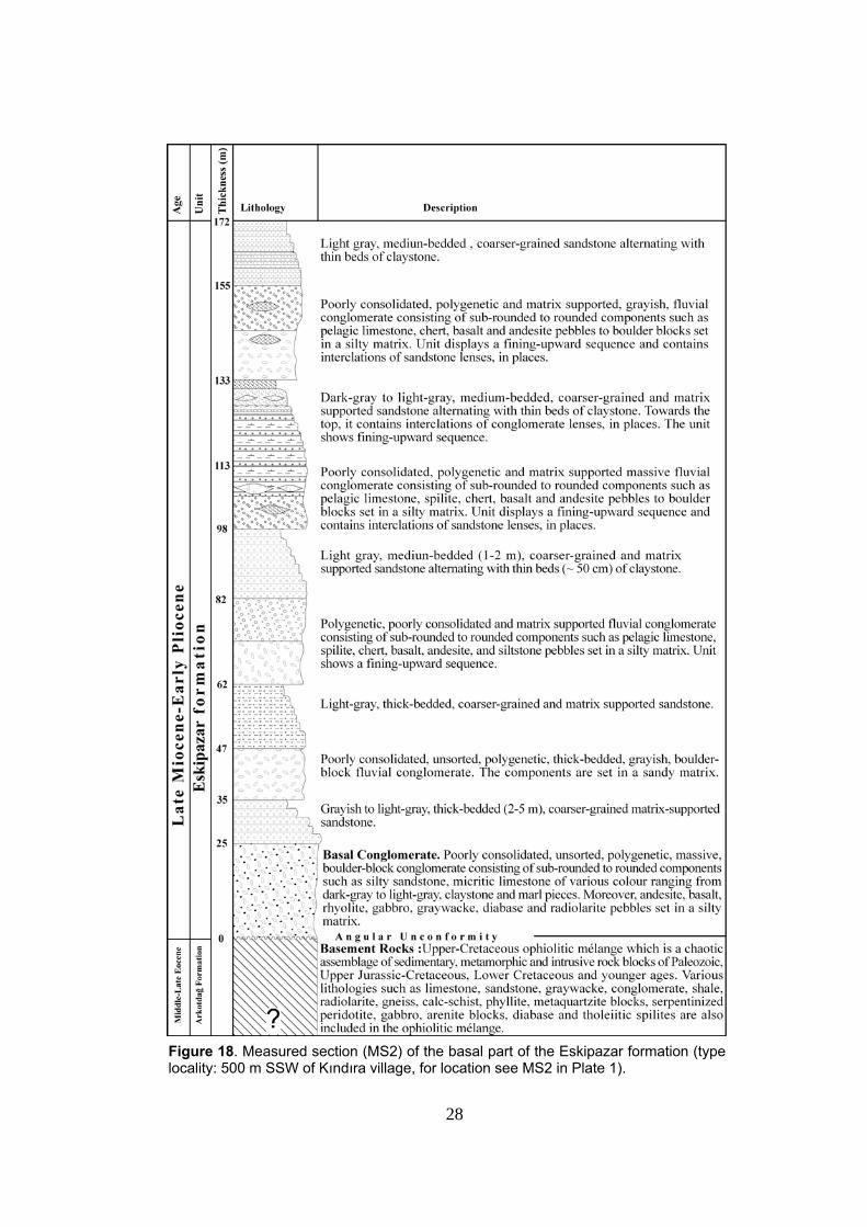
This formation can be subdivided, based on variations in its
lithological characteristics, into three parts. Each is analyzed and
documented by three measured sections (MS), namely MS2, MS3 and MS4
(see Plate 1 for their locations). MS2 constitutes the oldest and lowermost
part of the formation while MS4 constitutes the youngest and the
uppermost part of the formation.
The type locality of MS2 is ~2.5 km NW of Hasanallar Village (Plate
1). At this locality bottom portion of the Eskipazar formation is well
exposed and here this formation unconformably overlies the Arkotdağ
Formation (Figure 6).
26
The lowermost part of the section starts with poorly consolidated,
unsorted, polygenetic, massive boulder-block basal conglomerate
consisting of sub-rounded to rounded components such as silty
sandstone, micritic limestone of dark-gray to light gray tones, claystone
and marl clasts (Figure 16, 17). Moreover, andesite, basalt, rhyolite,
gabbro, graywacke, diabase, and radiolarite pebbles are also present. The
components are set in a silty matrix. This basal conglomerate is
succeeded by alternations of grayish to light-gray, thick-bedded (2-5 m),
coarser-grained sandstone and poorly consolidated, unsorted,
polygenetic, thickly-bedded, grayish boulder-block fluvial conglomerate.
Towards the top of the section, there is an alternation of coarser-grained,
matrix-supported sandstone with thin beds of claystone intercalations of
conglomerate lenses, in places. Towards the top, the sequence consists of
polygenetic and poorly consolidated fluvial conglomerate, displaying a
fining-upward succession and containing interclations of sandstone
lenses, in places. At the top, light-gray, medium-bedded (1-2 m) sandstone
alternates with thin beds of claystone (Figure 18).
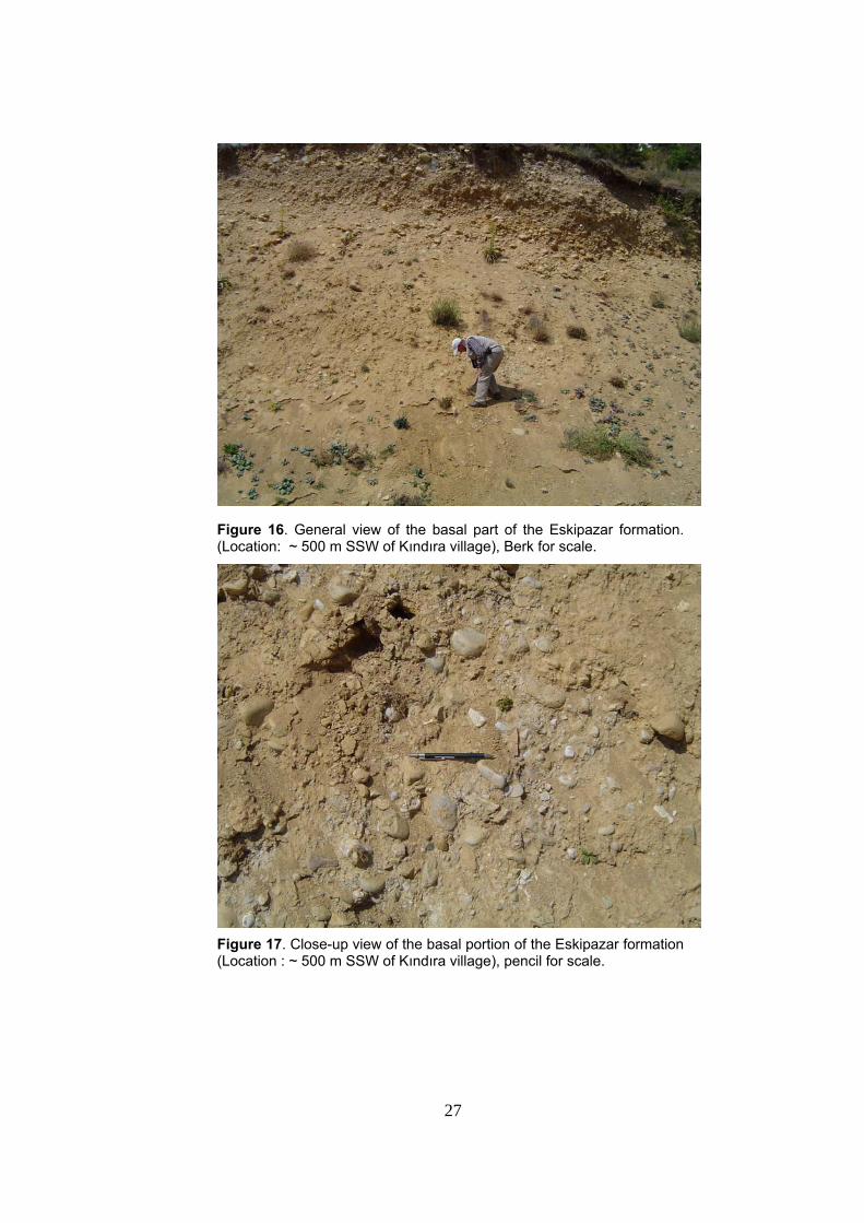
27
Figure 16. General view of the basal part of the Eskipazar formation. (Location: ~ 500 m SSW of Kındıra village), Berk for scale.
Figure 17. Close-up view of the basal portion of the Eskipazar formation (Location : ~ 500 m SSW of Kındıra village), pencil for scale.
28
Figure 18. Measured section (MS2) of the basal part of the Eskipazar formation (type locality: 500 m SSW of Kındıra village, for location see MS2 in Plate 1).
29
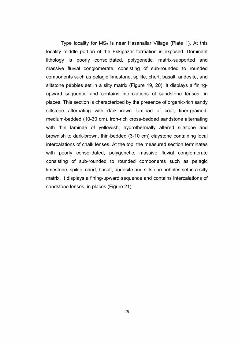
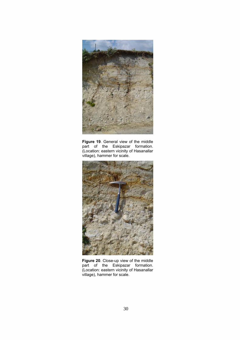
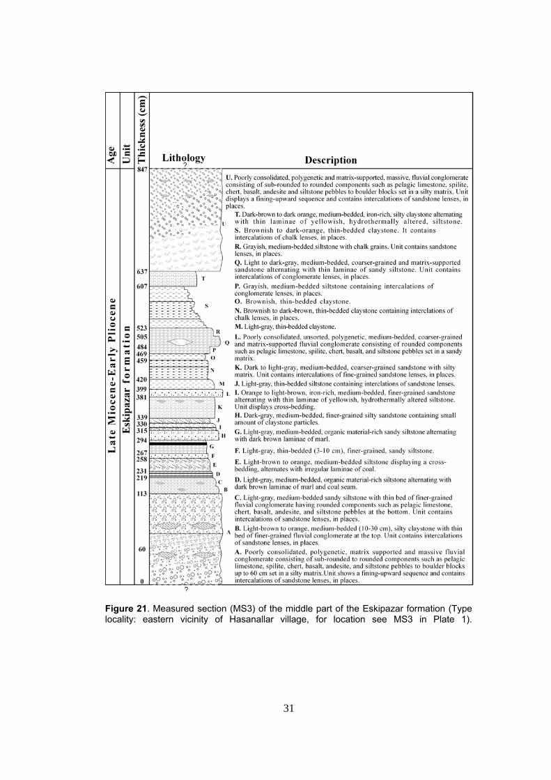
Type locality for MS3 is near Hasanallar Village (Plate 1). At this
locality middle portion of the Eskipazar formation is exposed. Dominant
lithology is poorly consolidated, polygenetic, matrix-supported and
massive fluvial conglomerate, consisting of sub-rounded to rounded
components such as pelagic limestone, spilite, chert, basalt, andesite, and
siltstone pebbles set in a silty matrix (Figure 19, 20). It displays a fining-
upward sequence and contains interclations of sandstone lenses, in
places. This section is characterized by the presence of organic-rich sandy
siltstone alternating with dark-brown laminae of coal, finer-grained,
medium-bedded (10-30 cm), iron-rich cross-bedded sandstone alternating
with thin laminae of yellowish, hydrothermally altered siltstone and
brownish to dark-brown, thin-bedded (3-10 cm) claystone containing local
intercalations of chalk lenses. At the top, the measured section terminates
with poorly consolidated, polygenetic, massive fluvial conglomerate
consisting of sub-rounded to rounded components such as pelagic
limestone, spilite, chert, basalt, andesite and siltstone pebbles set in a silty
matrix. It displays a fining-upward sequence and contains intercalations of
sandstone lenses, in places (Figure 21).
30
Figure 19. General view of the middle part of the Eskipazar formation. (Location: eastern vicinity of Hasanallar village), hammer for scale.
Figure 20. Close-up view of the middle part of the Eskipazar formation. (Location: eastern vicinity of Hasanallar village), hammer for scale.
31
Figure 21. Measured section (MS3) of the middle part of the Eskipazar formation (Type locality: eastern vicinity of Hasanallar village, for location see MS3 in Plate 1).
32
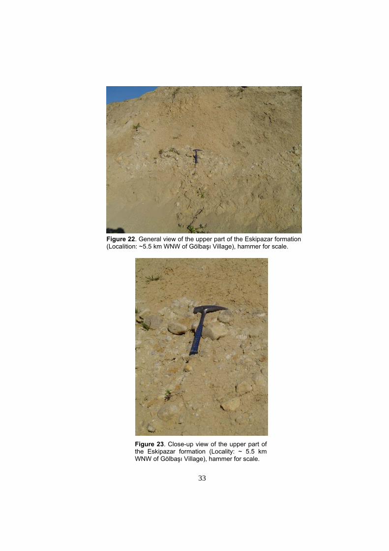
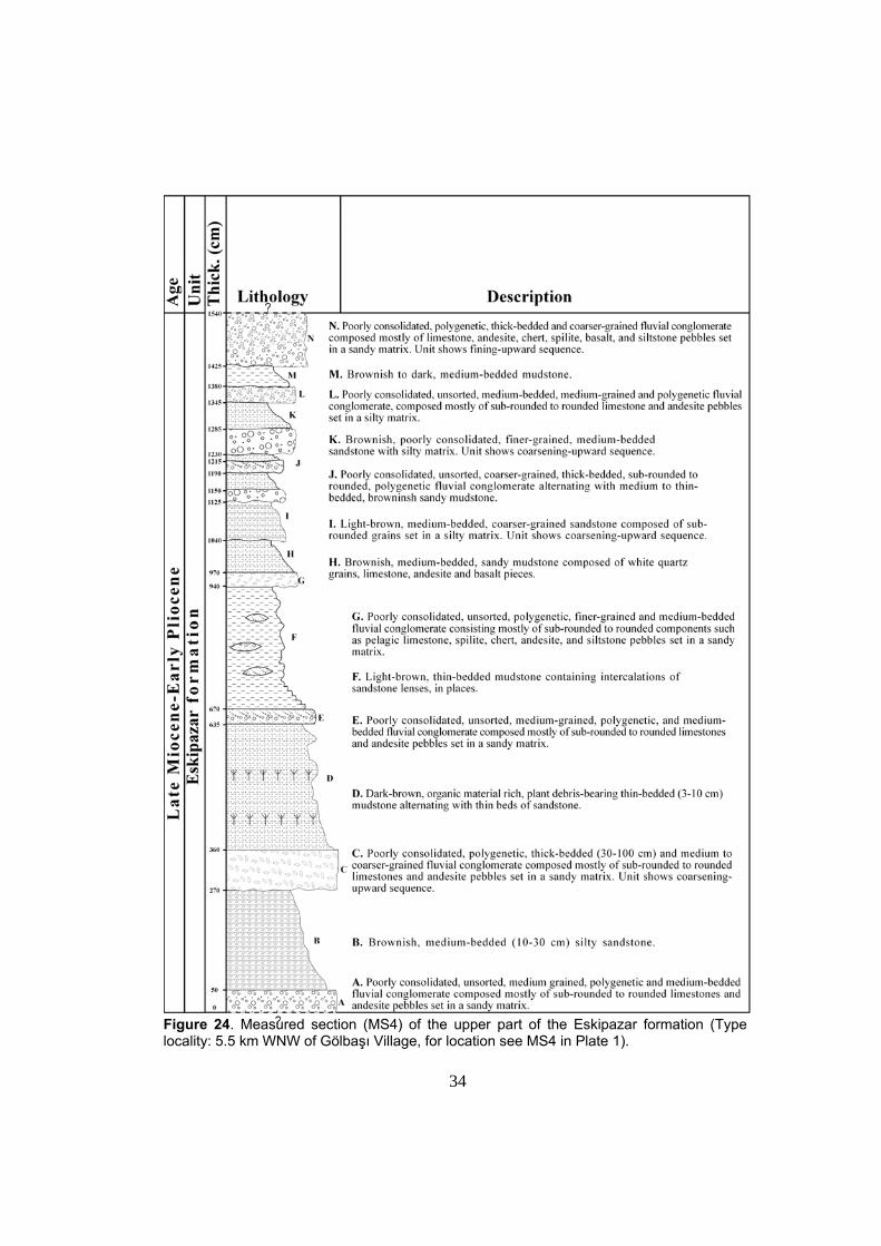
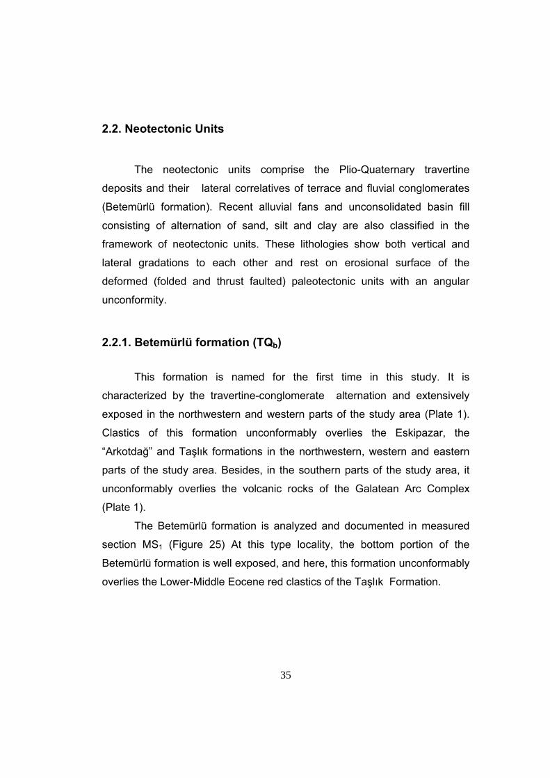
Type locality for MS4 is about 5.5 km WNW of Gölbaşı village (Plate
1). At this locality upper part of the Eskipazar formation is exposed (Figures
22, 23). The unit here starts with poorly consolidated, polygenetic and
medium-to coarse-grained fluvial conglomerate, composed mostly of
rounded to sub-rounded limestone, andesite, rhyolite and basalt pebbles set
in a sandy matrix.
The measured section MS3 is characterized by brownish, medium-
bedded (10-30 cm) silty sandstone, dark-brown, organic material-rich, plant
debris-bearing thin-bedded (3-10 cm) mudstone alternating with thin beds of
sandstone, and light-brown, thin-bedded mudstone containing intercalations
of sandstone lenses. At the top, the section terminates with poorly
consolidated, polygenetic, thickly-bedded and coarser-grained fluvial
conglomerate composed mostly of limestone, andesite, chert, spilite, basalt,
and siltstone pebbles set in a sandy matrix. Unit shows first fining-upward
sequence, later coarsening-upward nature (Figure 24).
The combined thickness of the Eskipazar formation is about 196 m
and contains micro- and macro mammalian fossil assemblages as
mentioned by Şaroğlu et al. (1995). Based on the fossil content of fossils of
Miyomimus sp., Spalacidae gen. et sp. indet, Talpidae gen. et sp. indet
(Desmana or Dibolia) found in this formation, Şaroğlu et al. (1995) assigned
a Late Miocene-Early Pliocene age to the “Pazarbaşı Formation”, i.e. to the
Eskipazar formation of this study. This formation is dominated by fluvial
deposits of conglomerate, cross-bedded sandstone and mudstone. Under
the light of these findings it is proposed that the Eskipazar formation was
deposited in a fluvio-lacustrine environment.
33
Figure 22. General view of the upper part of the Eskipazar formation (Localition: ~5.5 km WNW of Gölbaşı Village), hammer for scale.
Figure 23. Close-up view of the upper part of
the Eskipazar formation (Locality: ~ 5.5 km WNW of Gölbaşı Village), hammer for scale.
34
Figure 24. Measured section (MS4) of the upper part of the Eskipazar formation (Type locality: 5.5 km WNW of Gölbaşı Village, for location see MS4 in Plate 1).
35
2.2. Neotectonic Units
The neotectonic units comprise the Plio-Quaternary travertine
deposits and their lateral correlatives of terrace and fluvial conglomerates
(Betemürlü formation). Recent alluvial fans and unconsolidated basin fill
consisting of alternation of sand, silt and clay are also classified in the
framework of neotectonic units. These lithologies show both vertical and
lateral gradations to each other and rest on erosional surface of the
deformed (folded and thrust faulted) paleotectonic units with an angular
unconformity.
2.2.1. Betemürlü formation (TQb)
This formation is named for the first time in this study. It is
characterized by the travertine-conglomerate alternation and extensively
exposed in the northwestern and western parts of the study area (Plate 1).
Clastics of this formation unconformably overlies the Eskipazar, the
“Arkotdağ” and Taşlık formations in the northwestern, western and eastern
parts of the study area. Besides, in the southern parts of the study area, it
unconformably overlies the volcanic rocks of the Galatean Arc Complex
(Plate 1).
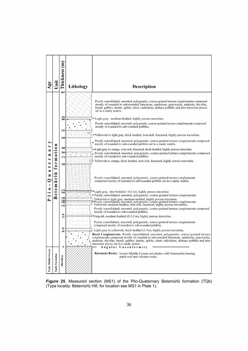
The Betemürlü formation is analyzed and documented in measured
section MS1 (Figure 25) At this type locality, the bottom portion of the
Betemürlü formation is well exposed, and here, this formation unconformably
overlies the Lower-Middle Eocene red clastics of the Taşlık Formation.
36
Figure 25. Measured section (MS1) of the Plio-Quaternary Betemürlü formation (TQb) (Type locality: Betemürlü Hill, for location see MS1 in Plate 1).
37
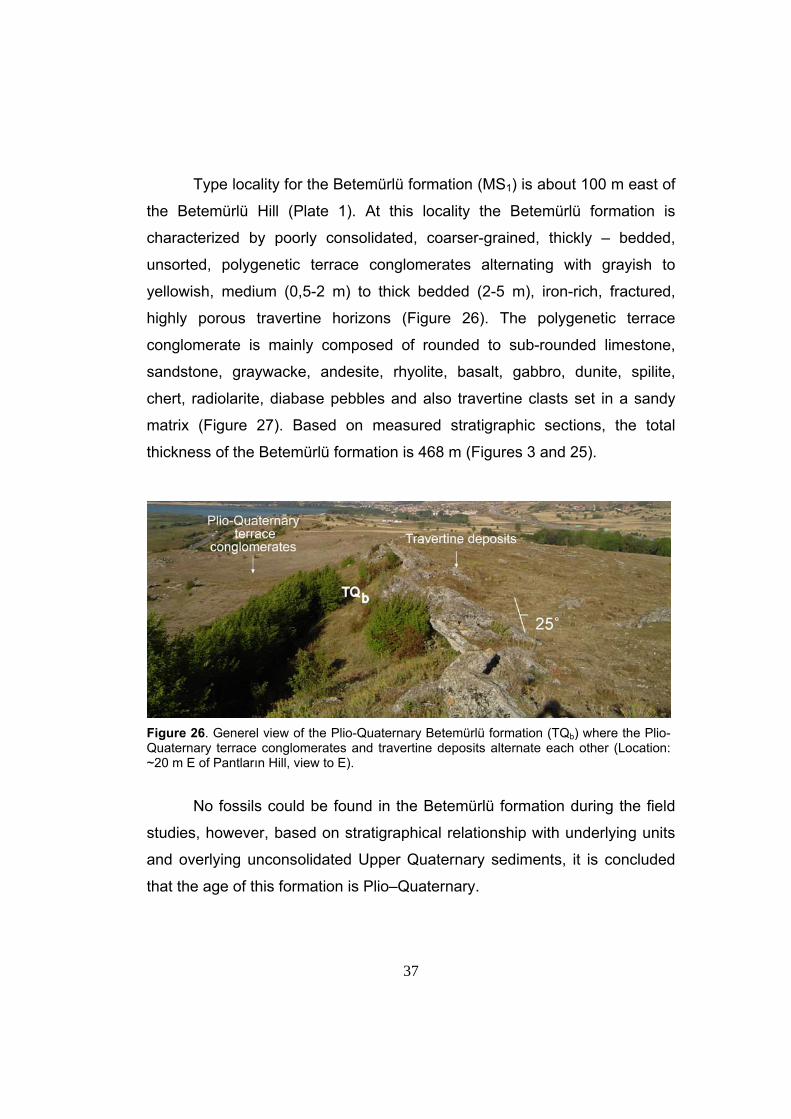
Type locality for the Betemürlü formation (MS1) is about 100 m east of
the Betemürlü Hill (Plate 1). At this locality the Betemürlü formation is
characterized by poorly consolidated, coarser-grained, thickly – bedded,
unsorted, polygenetic terrace conglomerates alternating with grayish to
yellowish, medium (0,5-2 m) to thick bedded (2-5 m), iron-rich, fractured,
highly porous travertine horizons (Figure 26). The polygenetic terrace
conglomerate is mainly composed of rounded to sub-rounded limestone,
sandstone, graywacke, andesite, rhyolite, basalt, gabbro, dunite, spilite,
chert, radiolarite, diabase pebbles and also travertine clasts set in a sandy
matrix (Figure 27). Based on measured stratigraphic sections, the total
thickness of the Betemürlü formation is 468 m (Figures 3 and 25).
Figure 26. Generel view of the Plio-Quaternary Betemürlü formation (TQb) where the Plio-Quaternary terrace conglomerates and travertine deposits alternate each other (Location: ~20 m E of Pantların Hill, view to E).
No fossils could be found in the Betemürlü formation during the field
studies, however, based on stratigraphical relationship with underlying units
and overlying unconsolidated Upper Quaternary sediments, it is concluded
that the age of this formation is Plio–Quaternary.
38
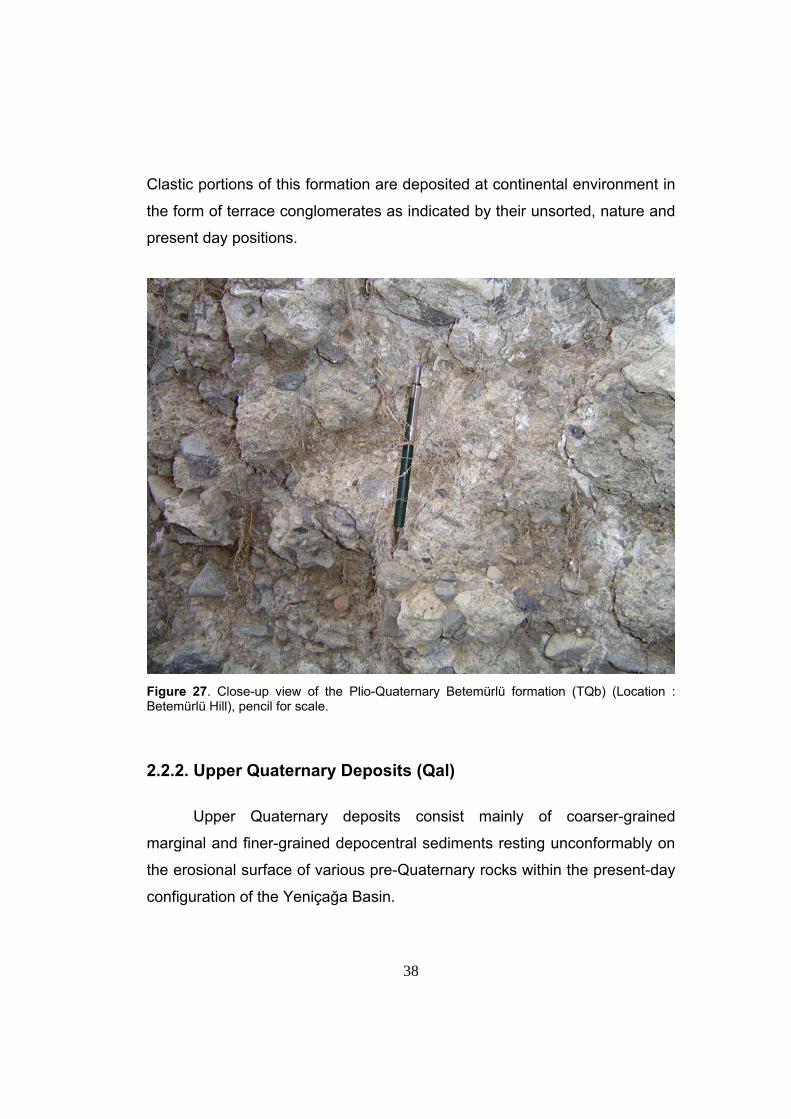
Clastic portions of this formation are deposited at continental environment in
the form of terrace conglomerates as indicated by their unsorted, nature and
present day positions.
Figure 27. Close-up view of the Plio-Quaternary Betemürlü formation (TQb) (Location : Betemürlü Hill), pencil for scale. 2.2.2. Upper Quaternary Deposits (Qal) Upper Quaternary deposits consist mainly of coarser-grained
marginal and finer-grained depocentral sediments resting unconformably on
the erosional surface of various pre-Quaternary rocks within the present-day
configuration of the Yeniçağa Basin.
39
Marginal sediments constitutes coarser-grained, recently developing
alluvial fan deposits that change from a few hundreds m2 to 2 km2 in size on
the map and occur in places where streams enter into the floor of the basin
and their transportation capacity is decreased. A series of diverse-sized
alluvial fans with their apices adjacent to the basin margin-bounding faults
are well exposed (Plate 1).
The fans indicate sudden change in the slope related to the Recent
activity of the basin-bounding faults. For example, the alluvial fan which is
observed about 2 km SW of Yukarıkuldan Village, near Dağtarla Hill (Plate
1) is perched on a flat topography and could not reach the flood plain floors.
This indicates the activity of one of the segments of the Yukarı Kuldan Fault
Set.
Depocentral sediments occur in a wide area across the basin floor
and consist of unconsolidated, fine-grained, organic-rich silt, peat, clay, mud,
sand and lensoidal pebbles. These are mostly the meandering river, sheet
flow and swamp deposits. At the eastern and western ends of the basin,
depocentral sediments are confined to a narrow zones parallel to stream
beds flowing into the basin. However, towards the central part of the basin,
they widen and cover an area of 5 km wide and 15 km long (Plate 1).
Thickness of fine-grained depocentral sediments range from 30 to
125 m. However, borehole drilled by Turkish Hydrolic Works (DSİ) in the
basin floor penetrated 89 m of unconsolidated sediments in south of Adaköy
located in the Yeniçağa basin floor (Yücel, 1969) (Plate 1).
40
CHAPTER 3
STRUCTURAL GEOLOGY
This chapter deals with the description and analysis of the
geological structures observed within the study area. Structural elements
include syn-depositional growth faults and shear fractures, beds,
unconformities, folds and faults. Based on tectonic period during which
they formed, these structures are grouped into two major categories: (1)
paleotectonic structures, (2) neotectonic structures. The deformation of
pre-Neogene basement rocks lies outside the scope of this study. But,
paleotectonic structures deforming the latest paleotectonic unit of the
Upper Miocene-Lower Pliocene Eskipazar formation will be described
similar to neotectonic structures; this is important to determine the stress-
regime during the latest paleotectonic period. The structures formed by the
deformation of Eskipazar formation and the neotectonic structures shaping
the present day configuration and outline of the Yeniçağa Basin will be
described and analysed in detail.
The database for the structural analysis is obtained during
geological field mapping. In the field, attitudes of various planar and linear
structures such as strike, dip, trend-plunge and rake were measured; later
on, these raw data-sets were analyzed by using pole plots, histograms and
a computer software named as Data Base for Tectonic Orientations
(Tector) (Angelier, 1989).
Basically, “Tector” allows us to find the relationship between faults
and principal stress directions. This program simply processes the data
based on three sub-programs. Mesure, Tensor and Diagra are the
computer softwares provide the user principle stress directions. The
software ‘Diagra’ presents the results of the processed data on
41
stereographic projection which includes slip-planes and principle stress
axes.
3.1. Paleotectonic Structures
In the study area, paleotectonic structures are mainly subdivided
into two categories: (1) structures deforming pre-Neogene basement rocks
and (2) structures affecting the latest paleotectonic unit, the Upper
Miocene-Lower Pliocene Eskipazar formation.
3.1.1. Structures Deforming Pre-Neogene Basement Rocks
The study area is located within the Intra-Pontide Suture Zone
(Okay et al. 1997) which straddles the Rhodope-Pontide Fragments
(Pontide Zone) in the north and the Sakarya Zone (or Continent) in the
south. The Pontide Zone is represented mainly by the İstanbul-Zonguldak
Unit while the Sakarya Zone is situated to the south of the İstanbul-
Zonguldak Unit that is bounded on its southside by the İzmir-Ankara
Suture (Elmas and Yiğitbaş, 2001). According to Şengör and Yılmaz
(1981), this Zone is thought to represent a suture belt of a sea way, the
Intra-Pontide Ocean, which existed during Late Cretaceous time and
closed by northward-directed subduction. This produced an ophiolitic
mélange (the “Arkotdağ Formation” of Tokay 1974).
In the study area, the “Arkotdağ Formation” is thrust over the
Lower-Middle Eocene Taşlık Formation along the Hamzaköy and Nallar
thrust faults.
42
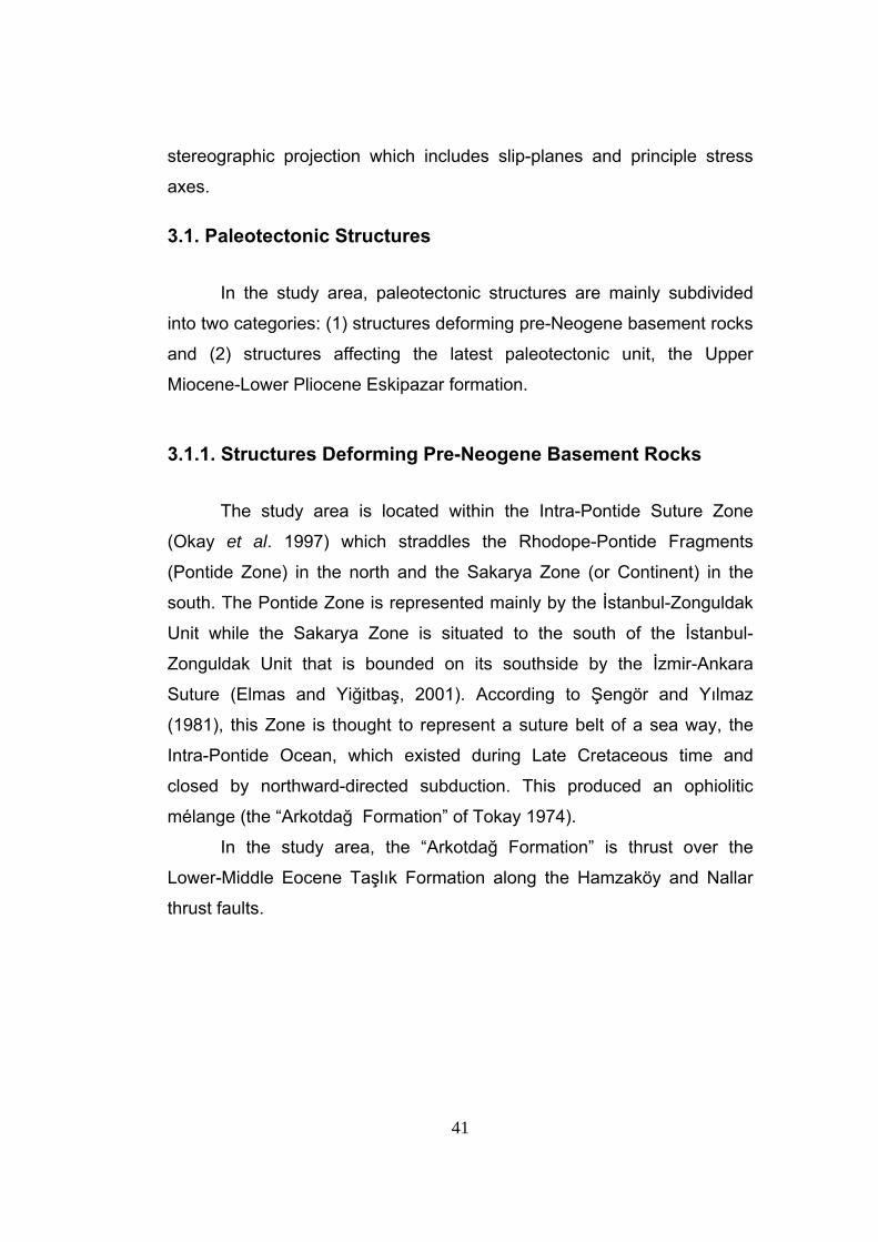
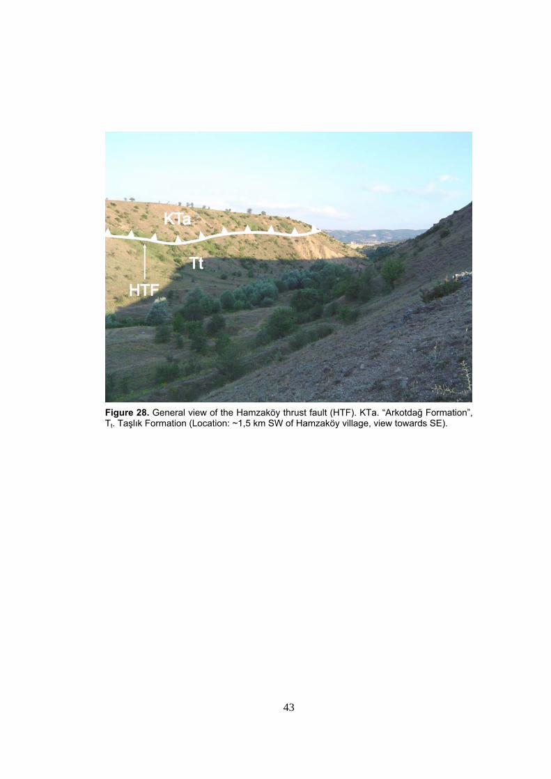
3.1.1.1. The Hamzaköy Thrust Fault
The Hamzaköy thrust fault is exposed in the NW corner of the
Yeniçağa Basin around Hamzaköy village and Akbayır Hill (Figure 28 and
geological cross-section A1-A1 in Figure 29). It is about 3 km long and
displays a curved to curvilinear fault trace; it is well exposed within the
Değirmen stream valley where no fault plane is observed. Nevertheless,
according to elevation change along the trace of the thrust fault, on the
map, the dip of the Hamzaköy thrust fault should be less than 20°. In the
SW end, the Hamzaköy thrust fault is displaced by one of the faults of the
Değirmen fault set (Plate 1). The Hamzaköy thrust fault is overlain
unconformably by the Upper Miocene-Lower Pliocene Eskipazar formation
(cross-section A2-A2 on Figure 29). Therefore, the age of the thrusting
must be younger than Middle Eocene but older than Late Miocene.
3.1.1.2. The Nallar Thrust Fault
The Nallar thrust fault is exposed in the western corner of the
Yeniçağa Basin around Nallar village and Kanlı Stream. It is about 3 km
long and displays a curvilenar fault trace and convex pattern in SE
direction, indicating NW to SE-directed tectonic transport (Plate 1 and
geological cross-section A1-A1 in Figure 29). Along the Hamzaköy and the Nallar thrust faults the Upper
Cretaceous “Arkotdağ Formation” is thrust over the Lower Middle Eocene
Taşlık Formation. The Nallar thrust fault contact is sealed by the Plio-
Quaternary Betemürlü formation along the Kanlı Stream (Plate 1). In
additon, the Hamzaköy thrust fault is displaced by the Değirmen fault set
and overlain unconformably by the Upper Miocene-Lower Pliocene
Eskipazar formation. According to this information, the Hamzaköy and
Nallar thrust faults were active in the period of post-Middle Eocene and
Early Pliocene.
43
Figure 28. General view of the Hamzaköy thrust fault (HTF). KTa. “Arkotdağ Formation”, Tt. Taşlık Formation (Location: ~1,5 km SW of Hamzaköy village, view towards SE).
44
Figure 29. Geological cross-sections showing geological structures, rock units and their relationships to each other.
45
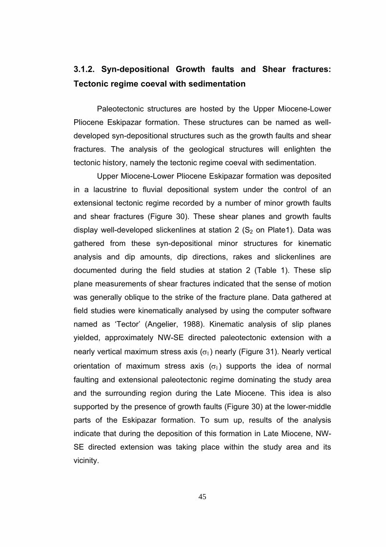
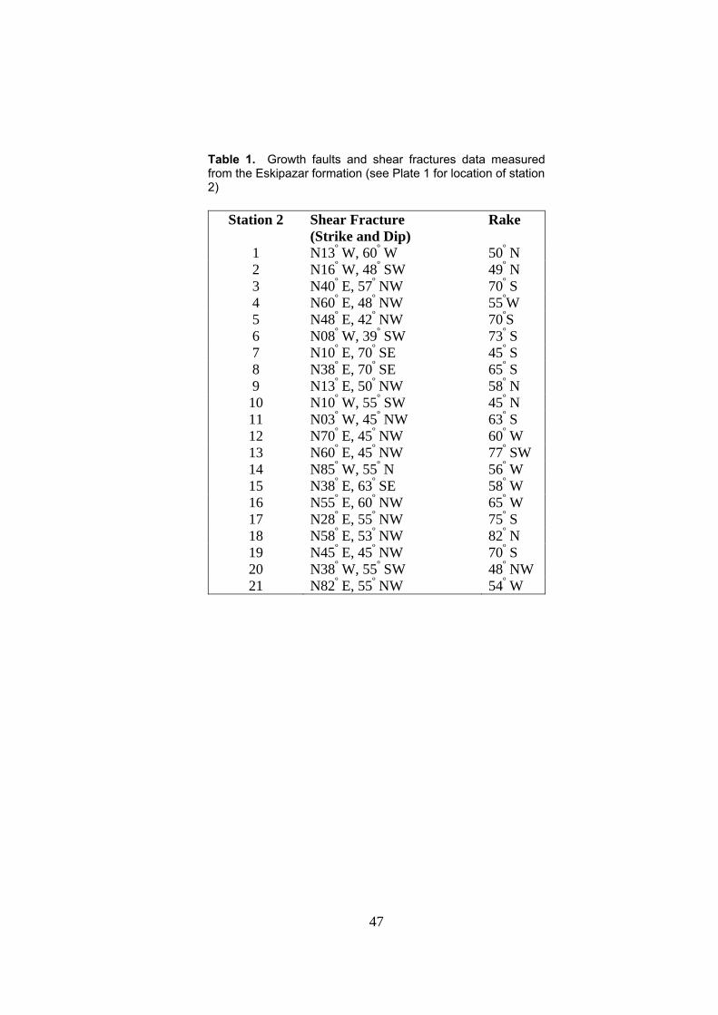
3.1.2. Syn-depositional Growth faults and Shear fractures: Tectonic regime coeval with sedimentation
Paleotectonic structures are hosted by the Upper Miocene-Lower
Pliocene Eskipazar formation. These structures can be named as well-
developed syn-depositional structures such as the growth faults and shear
fractures. The analysis of the geological structures will enlighten the
tectonic history, namely the tectonic regime coeval with sedimentation.
Upper Miocene-Lower Pliocene Eskipazar formation was deposited
in a lacustrine to fluvial depositional system under the control of an
extensional tectonic regime recorded by a number of minor growth faults
and shear fractures (Figure 30). These shear planes and growth faults
display well-developed slickenlines at station 2 (S2 on Plate1). Data was
gathered from these syn-depositional minor structures for kinematic
analysis and dip amounts, dip directions, rakes and slickenlines are
documented during the field studies at station 2 (Table 1). These slip
plane measurements of shear fractures indicated that the sense of motion
was generally oblique to the strike of the fracture plane. Data gathered at
field studies were kinematically analysed by using the computer software
named as ‘Tector’ (Angelier, 1988). Kinematic analysis of slip planes
yielded, approximately NW-SE directed paleotectonic extension with a
nearly vertical maximum stress axis (σ1) nearly (Figure 31). Nearly vertical
orientation of maximum stress axis (σ1) supports the idea of normal
faulting and extensional paleotectonic regime dominating the study area
and the surrounding region during the Late Miocene. This idea is also
supported by the presence of growth faults (Figure 30) at the lower-middle
parts of the Eskipazar formation. To sum up, results of the analysis
indicate that during the deposition of this formation in Late Miocene, NW-
SE directed extension was taking place within the study area and its
vicinity.
46
Figure 30.Close-up view of the syn-depositional structures in the middle portion of the latest paleotectonic unit, the Eskipazar formation. GF: Growth faults, CB: Coss-bedding pointing out a paleoflow direction from WNW to ESE, SF: Shear fractures (Location : ~ 250 m ESE of Hasanallar village)
47
Table 1. Growth faults and shear fractures data measured from the Eskipazar formation (see Plate 1 for location of station 2)
Station 2 Shear Fracture (Strike and Dip)
Rake
1 N13º W, 60º W 50º N 2 N16º W, 48º SW 49º N 3 N40º E, 57º NW 70º S 4 N60º E, 48º NW 55ºW 5 N48º E, 42º NW 70ºS 6 N08º W, 39º SW 73º S 7 N10º E, 70º SE 45º S 8 N38º E, 70º SE 65º S 9 N13º E, 50º NW 58º N 10 N10º W, 55º SW 45º N 11 N03º W, 45º NW 63º S 12 N70º E, 45º NW 60º W 13 N60º E, 45º NW 77º SW 14 N85º W, 55º N 56º W 15 N38º E, 63º SE 58º W 16 N55º E, 60º NW 65º W 17 N28º E, 55º NW 75º S 18 N58º E, 53º NW 82º N 19 N45º E, 45º NW 70º S 20 N38º W, 55º SW 48º NW 21 N82º E, 55º NW 54º W
48
Figure 31. Kinematic analysis within the Eskipazar formation at Station 2 (see Plate 1 for location) (Location: ~ 500 m ESE of Hasanallar Village ). The diagram shows the streographic plots of syn-depositional growth faults and the shear planes with orientations of slip lines. The orientation of these structures strongly reveal an extensional tectonic regime dominated by normal faulting and related fractures during the sedimentation of the Upper Miocene-Lower Pliocene Eskipazar formation. T: extension direction.
49
3.1.3. Structures Deforming Latest Paleotectonic Unit
Paleotectonic structures are hosted by the Upper Miocene-Lower
Pliocene Eskipazar formation. These structures can be named as tilted
beds, and folds. The analysis of the geological structures will enlighten the
tectonic history, namely the phase(s) of deformation of the study area prior
to onset of Neotectonic regime.
3.1.3.1. Tilted Beds
The outcrops of the Eskipazar formation exposed at road cuts and
quarry benches within the study area projecting the well-developed beds
and bedding planes with thicknesses ranging from few tens of centimeters
to tens of meters. The attitudes of these bedding planes, located in the
northern part of the study area (Plate 1) are documented and mapped at
1/25.000 scale by measuring their dip directions and dip amounts.
Observations related to these measurements within the study area
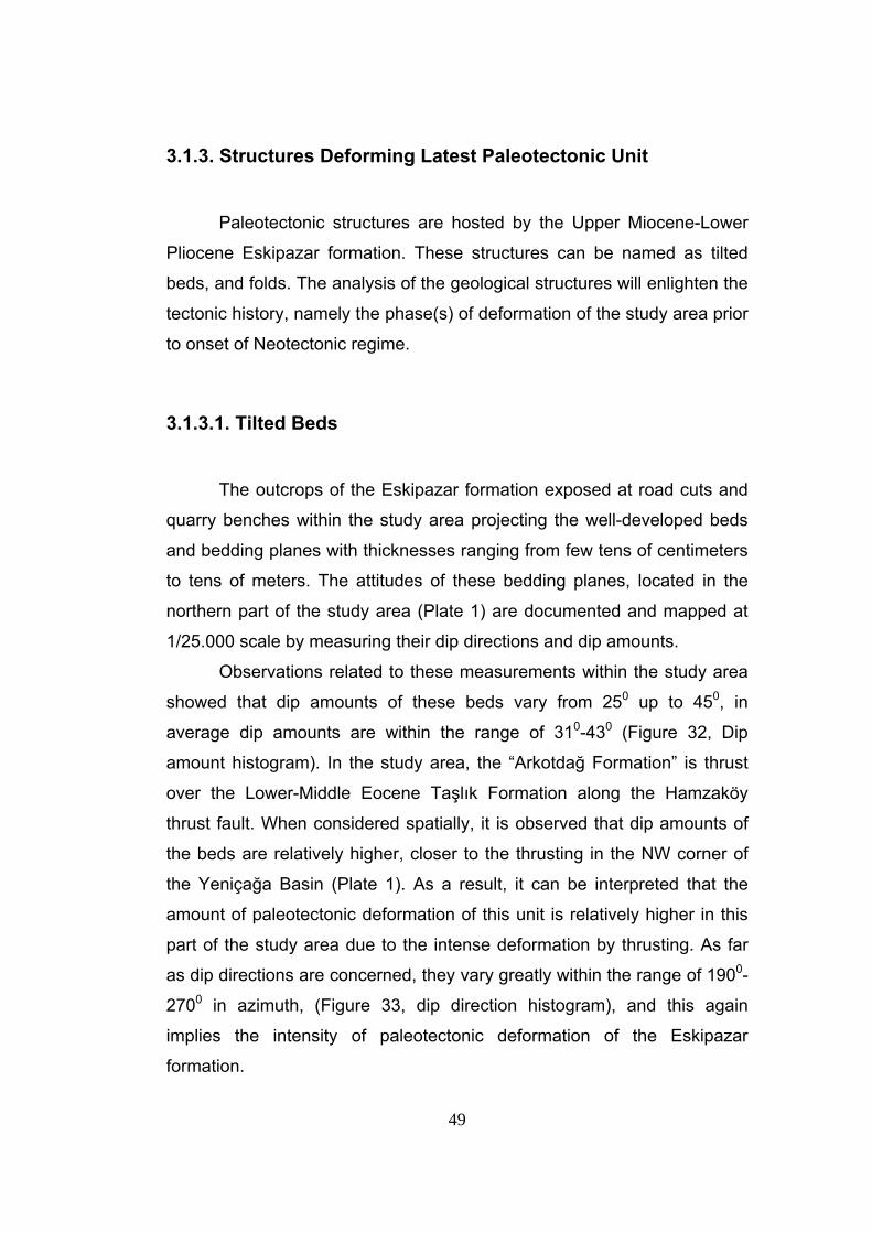
showed that dip amounts of these beds vary from 250 up to 450, in
average dip amounts are within the range of 310-430 (Figure 32, Dip
amount histogram). In the study area, the “Arkotdağ Formation” is thrust
over the Lower-Middle Eocene Taşlık Formation along the Hamzaköy
thrust fault. When considered spatially, it is observed that dip amounts of
the beds are relatively higher, closer to the thrusting in the NW corner of
the Yeniçağa Basin (Plate 1). As a result, it can be interpreted that the
amount of paleotectonic deformation of this unit is relatively higher in this
part of the study area due to the intense deformation by thrusting. As far
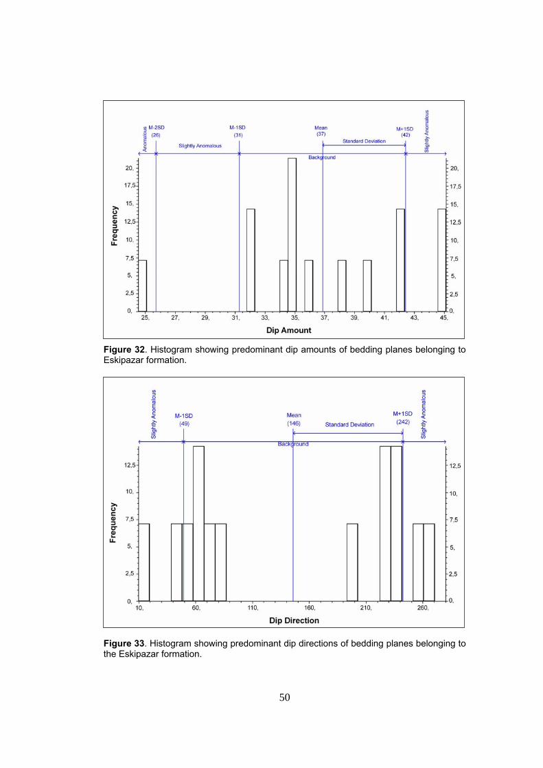
as dip directions are concerned, they vary greatly within the range of 1900-
2700 in azimuth, (Figure 33, dip direction histogram), and this again
implies the intensity of paleotectonic deformation of the Eskipazar
formation.
50
Figure 32. Histogram showing predominant dip amounts of bedding planes belonging to Eskipazar formation. Figure 33. Histogram showing predominant dip directions of bedding planes belonging to the Eskipazar formation.
51
3.1.3.2. Folds
According to field geological mapping and strike-dip measurements
taken at 1/25.000 scale, the bedding planes revealed several synclines
and anticlines with different tightness at different localities of the Eskipazar
formation within the study area. The fold axes of these folds are plotted on
geological map of the study area (Plate 1) by the help of the strike and dip
measurements.
The folds hosted by the Eskipazar formation differ in tightness from
place to place within the study area. In the northern part of the study area
(southwestern part of the Körükyanı Hill, Plate 1) these folds occur as tight
folds with interlimb angles (Ramsay 1967) ranging from 55° to 89° (section
A1-A1 in Figure 29). On the other hand, in northern part of the study area,
near Aliağa village, Eskipazar formation constitutes open fold with
interlimb angle around 130° (Figure 34, cross-section A2-A2 in Figure 29).
This analysis of tightness of folds may imply to that the paleotectonic
deformation of the Eskipazar formation was relatively more intense
compared with the other parts of the formation constituting an open fold.
The axes of the anticline and syncline display a parallel-subparallel
pattern with a NW-SE- to NNW-SSE- direction. The folds become tightly
packed resulting in closely spaced fold axes in the southwestern and
northwestern parts of the Eskipazar formation and this is well observed in
geological map of the study area (cross-section A1-A1 in Figure 29). The
length of the fold axes range from few hundreds of meters to kilometres.
Based on the NW-SE to NNW-SSE trends of the fold axes, it can be
interpreted that these folds are formed by nearly NE-SW directed (Figure
34) compressional stress, which is nearly perpendicular to the trend of the
fold axes. In addition to this, stereographic pole plots of 14 bedding planes
from the Upper Miocene-Lower Pliocene Eskipazar formation confirmed
the above mentioned paleotectonic compressional stress direction (Figure
35).
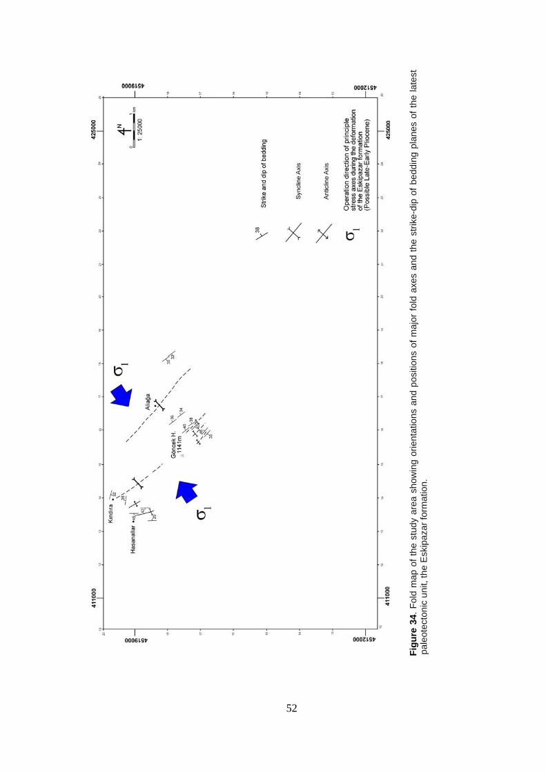
Fi
gure
34.
Fol
d m
ap o
f the
stu
dy a
rea
show
ing
orie
ntat
ions
and
pos
ition
s of
maj
or fo
ld a
xes
and
the
strik
e-di
p of
bed
ding
pla
nes
of th
e la
test
pa
leot
ecto
nic
unit,
the
Esk
ipaz
ar fo
rmat
ion.
52
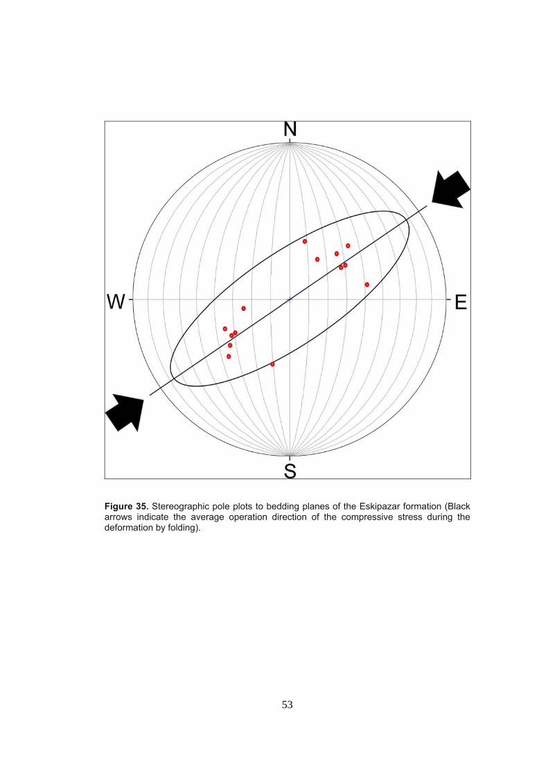
53
Figure 35. Stereographic pole plots to bedding planes of the Eskipazar formation (Black arrows indicate the average operation direction of the compressive stress during the deformation by folding).
54
3.2. Neotectonic Structures
In this section, the neotectonic structures that are exposed within
the study area will be discussed. Meanwhile, the term “Neotectonic” is
considered as a period of time elapsed since the last major wholesale
tectonic reorganization in a region of interest (Şengör, 1980). According to
this definition, the structures developed under the present day strike-slip
tectonic regime in the study area are defined as the Neotectonic structures
which constitute beds, unconformities and faults. The analysis of these
structures will enlighten the characteristics of the present-day deformation
taking place within the study area and will aid the interpretation of the final
stage evolution of the Yeniçağa Basin.
3.2.1. Beds
Undeformed younger infill consists of the Plio-Quaternary
Betemürlü formation and Holocene sediments. The Betemürlü formation is
characterized by well-bedded terrace conglomerates alternating with
medium to thick-bedded, highly porous travertines. Original dip of the beds
are nearly horizontal within the major parts of the study area, but it
reaches up to 36° in places, in and nearby the elongated hill bounded by
the Gerede Fault in the north, and Yeniçağa Fault in the south.
Bedding with thickness ranging from 0.5 m to 5 m is well observed
along the pressure ridge near the Betemürlü Hill and the Pantların Hill
(Plate 1) (Figure 26). In contrast, the Quaternary deposits are represented
by unconsolidated alluvium containing silt, clay, peat, mud and sand.
55
3.2.2. Unconformities
The Neotectonic units overlie the deformed paleotectonic basement
rocks including also the Upper Miocene-Lower Pliocene Eskipazar
formation with anguar unconformity. In addition, in certain parts of the
study area, the angular differences between nearly flat-lying unconformity
surfaces and the underlying Eskipazar formation range from 15° to 30°
(Figure 29). The age of angular the unconformity between the Eskipazar
formation and overlying Betemürlü formation is Late-Early Pliocene.
On the other hand, in several parts of the study area, the “Arkotdağ
Formation” is unconformably overlain by the terrace conglomerates of the
Plio-Quaternary Betemürlü formation (Figure 29).
In addition, an erosional surface, which is a short-term time gap in
the nature of disconformity occurs between the Betemürlü formation and
the Upper Quaternary alluvial fill. It is important to note that these units are
nearly horizontal and undeformed. The age of this disconformity is
probably Late Pleistocene.
3.2.3 Faults
Based on trends, faults observed and mapped within the study area
are classified into four categories : (1) ENE-WSW-trending faults , (2) NE-
SW-trending faults, (3) NW-SE-trending faults, and (4) E-W- trending
faults. They occur as nearly vertical strike-slip faults and high-angle (> 750)
oblique-slip normal faults. The southern margin, northeastern and
northwestern ends of the Yeniçağa Basin are controlled by the active
strike-slip faults. The southern margin of the Yeniçağa Basin is bounded
by the WSW-ENE- trending Aşağı Kuldan fault (~16 km) belonging to the
Gerede Fault Zone.
56
Another fault belonging to this fault zone is generally WSW-ENE- trending
Gerede Fault Zone Master Strand (GFZMS) (Gerede Fault) (~17 km) and
it partly controls the southwestern and eastern margins of the Yeniçağa
Basin, and E-W- to WSW-ENE-trending Yeniçağa Fault (~14 km). Beyond
these faults, the nearly SW-NE-trending Şahnalar fault set (~5,5 km), the
WNW-ESE-trending Doğancı fault set (~2 km) and the nearly SW-NE-
trending Yukarı Kuldan fault set (~ 3 km), comprise the Gerede Fault
Zone, and play an important role in the morphologic evolution of the
southern parts of the Yeniçağa Basin. In the northern parts of the basin,
the SW-NE-trending Hamzabey fault set (~ 4 km) and the nearly E-W-
trending Değirmen fault set (~ 5 km) control the nothwestern margin of the
Yeniçağa Basin. On the other hand, the northern and the northeastern
margins of the basin is bounded by the nearly N-S-trending Çağa fault (~ 2
km), the NW-SE trending İzmirli fault set, and the nearly NE-SW trending
Sarayçalı fault (~2 km). In addition to this, the morphology of the
northeastern part of the Yeniçağa Basin is controlled by the E-W- to NW-
SE- trending Eroğlu fault (~ 4,5 km ) and the E-W- trending Yamanlar fault
(~ 3 km) (Figure 36).
Within the study area, the existence and activeness of the faults are
indicated by sudden break in slope, well-preserved fault-scarps with or
without slickensides, downcutting of streams, widespread development of
marginal alluvial fans, and terraced Plio-Quaternary conglomerates of the
Betemürlü formation.
The basin margins and the morphology of the basin are controlled
by the active strike-slip faults and oblique-slip normal faults with minor
amount of dextral or sinistral strike-slip components (Figures 37, 38).
Within the study area, several strike-slip related features are present, such
as the pressure ridges and sagponds nearly parallel to the general trend of
the basin.
Major faults taking part in the neotectonic evolution of the Yeniçağa
Basin will be explained in more detail in the following sections.
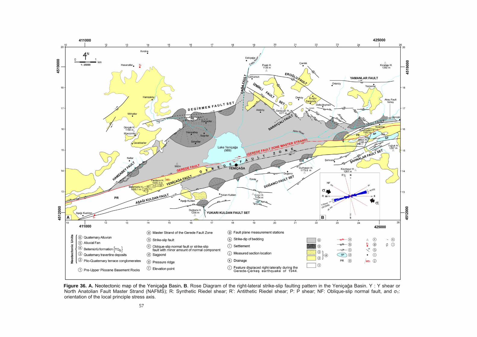
57
Figure 36. A. Neotectonic map of the Yeniçağa Basin. B. Rose Diagram of the right-lateral strike-slip faulting pattern in the Yeniçağa Basin. Y : Y shear or North Anatolian Fault Master Strand (NAFMS); R: Synthetic Riedel shear; R’: Antithetic Riedel shear; P: P shear; NF: Oblique-slip normal fault, and σ1: orientation of the local principle stress axis.
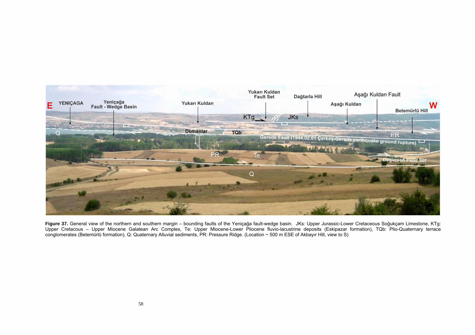
58
Figure 37. General view of the northern and southern margin – bounding faults of the Yeniçağa fault-wedge basin. JKs: Upper Jurassic-Lower Cretaceous Soğukçam Limestone, KTg: Upper Cretacous – Upper Miocene Galatean Arc Complex, Te: Upper Miocene-Lower Pliocene fluvio-lacustrine deposits (Eskipazar formation), TQb: Plio-Quaternary terrace conglomerates (Betemürlü formation), Q: Quaternary Alluvial sediments, PR: Pressure Ridge. (Location ~ 500 m ESE of Akbayır Hill, view to S)
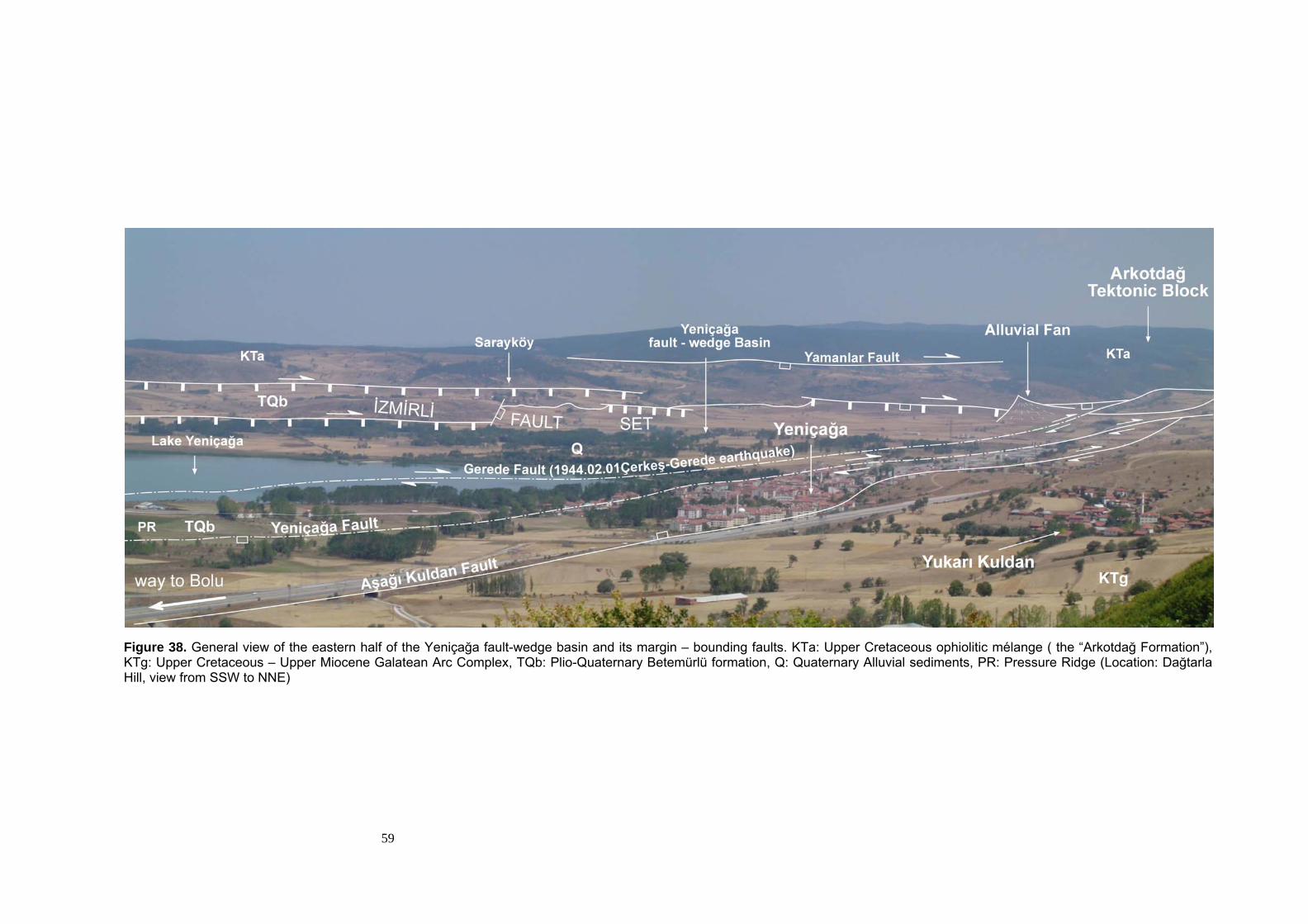
59
Figure 38. General view of the eastern half of the Yeniçağa fault-wedge basin and its margin – bounding faults. KTa: Upper Cretaceous ophiolitic mélange ( the “Arkotdağ Formation”), KTg: Upper Cretaceous – Upper Miocene Galatean Arc Complex, TQb: Plio-Quaternary Betemürlü formation, Q: Quaternary Alluvial sediments, PR: Pressure Ridge (Location: Dağtarla Hill, view from SSW to NNE)
60
3.2.3.1. Gerede Fault Zone (GFZ)
The Gerede Fault Zone is first named by Koçyiğit (2003b). It
consists of the NE-SW- to ENE-WSW- trending dextral strike-slip faults
(Figure 36). The width of the fault zone ranges between 1 to 3 km
throughout its course. It is characterized by the several pressure ridges
and sagponds (Figure 39). The faults of the Gerede Fault Zone pass
through several villages, such as Şahnalar, Doğancı and Yukarı Kuldan.
One of the major faults which passes through the Yeniçağa County is the
Yeniçağa Fault (Plate 1) (Figures 36, 38). The faults comprising the
Gerede Fault Zone are the Aksu Fault, the Gerede Fault (Master Strand),
the Yeniçağa Fault, the Aşağı Kuldan Fault, the Şahnalar Fault Set, the
Doğancı Fault Set and the Yukarı Kuldan Fault Set (Plate 1). These faults
will be described in detail in the following sections.
3.2.3.1.1. Aksu Fault
The Aksu fault is first named in this study. It is located at the
eastern most of the Yeniçağa Basin (Figures 36, 39). The Aksu Fault
comprises a dextral strike-slip fault with minor amount of normal
component, displaying a nearly WSW-ENE- to SW-NE-trending curvilinear
pattern. The fault runs near Siyamlar and Ibrıcak villages and then it joins
with the Gerede Fault Zone Master Strand at the eastern tip of the
Yeniçağa Basin.
Through its course, it bounds the pressure ridge situated 500 m
WSW of Kınalıbelen hill from the north (Figure 39). This pressure ridge is
bounded by another subsidary splay fault passing through 250 m NE of
Kınalıbelen Hill at east. This subsidary fault splays off from the Gerede
Fault Zone Master Strand (GFZMS) in the south and joins with the Aksu
Fault in the northwest (Plate 1).
61
Figure 39. General view of the Siyamlar section of the Gerede Fault Zone and the Master Fault indicated by the 1944.02.01 Çerkeş-Gerede earthquake ground rupture. KTa: Upper Cretaceous ophiolitic mélange ( the “Arkotdağ Formation”), KTg: Upper Cretaceous – Upper Miocene Galatean Arc Complex, Tt: Lower-Middle Eocene Taşlık Formation, TQb: Plio-Quaternary Betemürlü formation, PR: Pressure Ridge, SP. Sag Pond (Location ~ 500 m S of Siyamlar Village, view from S to N)
62
The length of the Aksu fault within the study area is 3 km, and it
juxtaposes the Taşlık Formation with the “Arkotdağ Formation” in the east,
but in further west it juxtaposes again the Taşlık Formation with
Quaternary fill of the Yeniçağa basin (Figure 36) (Plate 1).
The Aksu fault displays poorly developed fault scarps where it cuts
through the Taşlık Formation and morphologically it is followed through by
the deeply carved valley of the Aksu River within and outside of the study
area. The development of this deeply carved valley is due to the presence
of the weakness zone which is created by the Aksu fault.
In the study area, the existence and the activeness of the Aksu
Fault are indicated by sudden break in slope, fault scarp exposed at
northern part of outcrop of the Taşlık Formation, tectonic juxtaposition of
units of dissimilar age, origin, lithofacies and internal structure, the
downcutting of the Aksu River (a fault valley) and development of quite
large alluvial fans at its western part.
3.2.3.1.2. Gerede Fault (Master Strand of the Gerede Fault Zone)
This fault is first defined by Tokay (1973) as the “Gerede I” fault. In
this study it is referred to as the Gerede Fault (Master Strand). It partly
controls the eastern margin of the Yeniçağa Basin (Figure 36). It
comprises a curvilinear to linear dextral strike-slip fault, displaying
generally ENE-WSW trend. Starting from the eastern part of the study
area, the fault runs in nearly E-W- direction and curves to southwest, and
at 250 m south of Kınalıbelen Hill, it makes a restraining bending and
curves towards west. From this point, it runs nearly in E-W- trend for about
3 km and at 1 km west of the restraining bend, it is joined by the Aksu
Fault. In the further west, the fault continues in an ENE-WSW trend and
approximately 1,7 km NE of Aşağıkuzören village, it is joined by the
Hamzabey Fault Set (Figure 36).
63
Throughout its course, the fault bounds several pressure ridges and
sagponds. In near south of Kınalıbelen Hill it separates two adjacent
pressure ridges (Figure 39). They are the Selek Hill in the south and the
Kınalıbelen Hill in the north. There is a sagpond between these two
pressure ridges. The sagpond here is bounded in its NW part by the
Gerede Fault Zone Master Strand. In the western part of the study area,
this fault bounds another pressure ridge located between Aşağıkuzören
and Lake Yeniçağa (Figures 36, 40). The part of Gerede Fault that is
exposed within the study area has a length of nearly 17 km. In the west, it
juxtaposes the Plio-Quaternary Betemürlü formation and the Lower-Middle
Eocene Taşlık Formation with the Quaternary fill of the Yeniçağa Basin
(Plate 1).
The Gerede Fault is a dextral strike-slip fault, it does not display any
distinct fault scarp and consequently no slickensides could be observed on
this fault. However, the Gerede Fault is the most active strand of the
Gerede Fault Zone, and it is the source of the ground rupturing
earthquake, such as the 1944.02.01 Çerkeş-Gerede Earthquake. One of
the maximum offset of 7.28 m was measured along the line of older salix
trees displaced by the 1944.02.01 Çerkeş-Gerede earthquake (Figure 41).
64
Figure 40. General view of the western half of the Yeniçağa fault-wedge basin and its margin – bounding faults. JKs: Upper Jurassic-Lower Cretaceous Soğukçam Limestone, KTa: Upper Cretaceous ophiolitic mélange ( the “Arkotdağ Formation”), KTg: Upper Cretaceous – Upper Miocene Galatean Arc Complex, Tt: Lower-Middle Eocene Taşlık Formation, TQb: Plio-Quaternary Betemürlü formation, Q: Quaternary Alluvial sediments, PR: Pressure Ridge (Location ~ 2 km E of Yukari Kuldan Village, view from SE to NW)
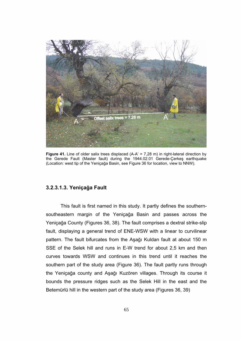
65
Figure 41. Line of older salix trees displaced (A-A’ = 7,28 m) in right-lateral direction by the Gerede Fault (Master fault) during the 1944.02.01 Gerede-Çerkeş earthquake (Location: west tip of the Yeniçağa Basin, see Figure 36 for location, view to NNW).
3.2.3.1.3. Yeniçağa Fault
This fault is first named in this study. It partly defines the southern-
southeastern margin of the Yeniçağa Basin and passes across the
Yeniçağa County (Figures 36, 38). The fault comprises a dextral strike-slip
fault, displaying a general trend of ENE-WSW with a linear to curvilinear
pattern. The fault bifurcates from the Aşağı Kuldan fault at about 150 m
SSE of the Selek hill and runs in E-W trend for about 2,5 km and then
curves towards WSW and continues in this trend until it reaches the
southern part of the study area (Figure 36). The fault partly runs through
the Yeniçağa county and Aşağı Kuzören villages. Through its course it
bounds the pressure ridges such as the Selek Hill in the east and the
Betemürlü hill in the western part of the study area (Figures 36, 39)
66
The part of the Yeniçağa fault exposed within the study area has a
length of approximately 14 km, and it mainly juxtaposes the Betemürlü
formation and the Taşlık Formation with the volcanics of the Galatean Arc
Complex (Plate 1)
Based on the morphological markers, the Yeniçağa fault is a dextral
strike-slip fault, but it displays no distinct fault scarps, and no slickensides
on this fault could be observed.
The existence and the activeness of the Yeniçağa Fault are
indicated by the tectonic juxtaposition of different units, and some
morphological indications such as the pressure ridges along its trace.
3.2.3.1.4. Aşağı Kuldan Fault
This fault is first named in this study. It determines the southern
margin of the Yeniçağa Basin (Figures 36, 37) and comprises dextral
strike-slip fault with minor amount of normal component. The downthrown
block of the fault lies in the north, and the upthrown block lies in the south
(Figure 29). In the eastern part of the basin, it runs to west nearly in an E-
W trend and then curves slightly to SW, approximately 750 m east of
Selek hill, and continues in this trend for about 1 km. In the further west, it
re-bends to E-W direction and runs in this direction for about 2 km.
Approximately 1 km NE of Durhasan Hill, it starts to curve slightly to WSW
direction and continues in this direction until it reaches the western end of
the study area. This fault possibly joins with the Yeniçağa fault in the
further southwest nearby the Aşağı Kuzören village (Figure 36)
Through its course, it bounds the southern margin of a sagpond that
is located approximately 750 m north of Tuğluk hill. In the further west, it is
characterized by diverse-sized alluvial fans with apices adjacent to the
fault itself.
67
The total length of the Aşağı Kuldan Fault is approximately 16 km.
This fault juxtaposes the Soğukçam limestones, the Betemürlü formation,
the Quaternary infill of the Yeniçağa Basin and the agglomerates of the
Galatean Arc Complex to each other (Plate 1). In other parts of the study
area, it juxtaposes volcanics of the Galatean Arc Complex with the
Quaternary sediments along its course (Plate 1).
The Aşağı Kuldan Fault dislays partly well-developed fault scarps,
where it cuts through the Soğukçam Limestone and partly the volcanics of
the Galatean Arc Complex (Plate 1).
The existence and the activeness of this fault are indicated by
sudden break in slope, fault scarps, tectonic juxtapostion of different units,
presence of straigthly alligned alluvial fans with apices adjacent to a fault,
and the presence of sagpond along its trace (Plate 1, Figures 36, 38)
3.2.3.1.5. Şahnalar Fault Set
Şahnalar fault set is first named in this study. It controls the
morphology of the eastern margin of the study area and comprises a
parallel to sub-parallel, closely-spaced basinward facing, linear to
curvilinear dextral strike-slip faults with minor amount of dip-slip
component. The fault set starts at approximately 500 m NNW of Tuğluk
Hill in the form of three NE-SW-trending closely spaced sub-parallel
strands and then continues to west in the form of single to two
discontinues strands. At approximately 250 m north and south of Şahnalar
village, the faults of this set curves towards E-W direction resulting in a
restraining bend where spacing of the faults increases and fault set comes
to end.
In the eastern part, the Şahnalar fault set creates a well-developed
step-like morphology (cross-section A3-A3 in Figure 29). In the further
west, as the faults of this set become more widely spaced, the steps get
wider.
68
At the western end of the Şahnalar fault set, the right-lateral offset of faults
are indicated by the outcrops of the Soğukçam Limestone with the
Galatean Arc Complex. The westward bending of the faults may be due to
the rheological control here, where the two faults of this fault set enter the
Soğukçam Limestone. Besides this, the termination of the fault set at this
locality may be due to the same rheological control here working together
with the restraining bending at this locality (Plate 1).
The Şahnalar fault set has a width ranging from approximately 250
m to 400 m from east to west, meaning that the fault set widens in
westward direction. The longest fault of this fault set measures
approximately 1 km (Figure 36). The fault set mainly juxtaposes the
Soğukçam Limestone with volcanic of the Galatean Arc Complex in its
western parts (Plate 1)
The Şahnalar fault set displays well-developed fault scarps at
localities where it creates a step-like morphology. Unfortunately, these
fault scarps do not display any slickensides indicating characteristics of the
faults. The scarps of the faults and offset of lithological boundaries along
these faults indicate that the fault set is made up of dextral strike-slip faults
with minor amount of dip-slip component.
3.2.3.1.6. Doğancı Fault Set
Doğancı Fault Set is first named in this study. It controls the
morphology of the southern margin of the Yeniçağa basin and comprises a
set of parallel to sub-parallel, linear to curvilinear, generally basinward-
facing, widely spaced dextral strike-slip faults with minor amount of dip-slip
components. The fault set starts at approximately 1 km NE and ENE of
Durhasan hill in the form of two parallel strands, and then continues to the
west in an NE-SW-trend. In the west of the Doğancı village, the faults of
Doğancı fault set changes their trend into nearly E-W to WNW-ESE.
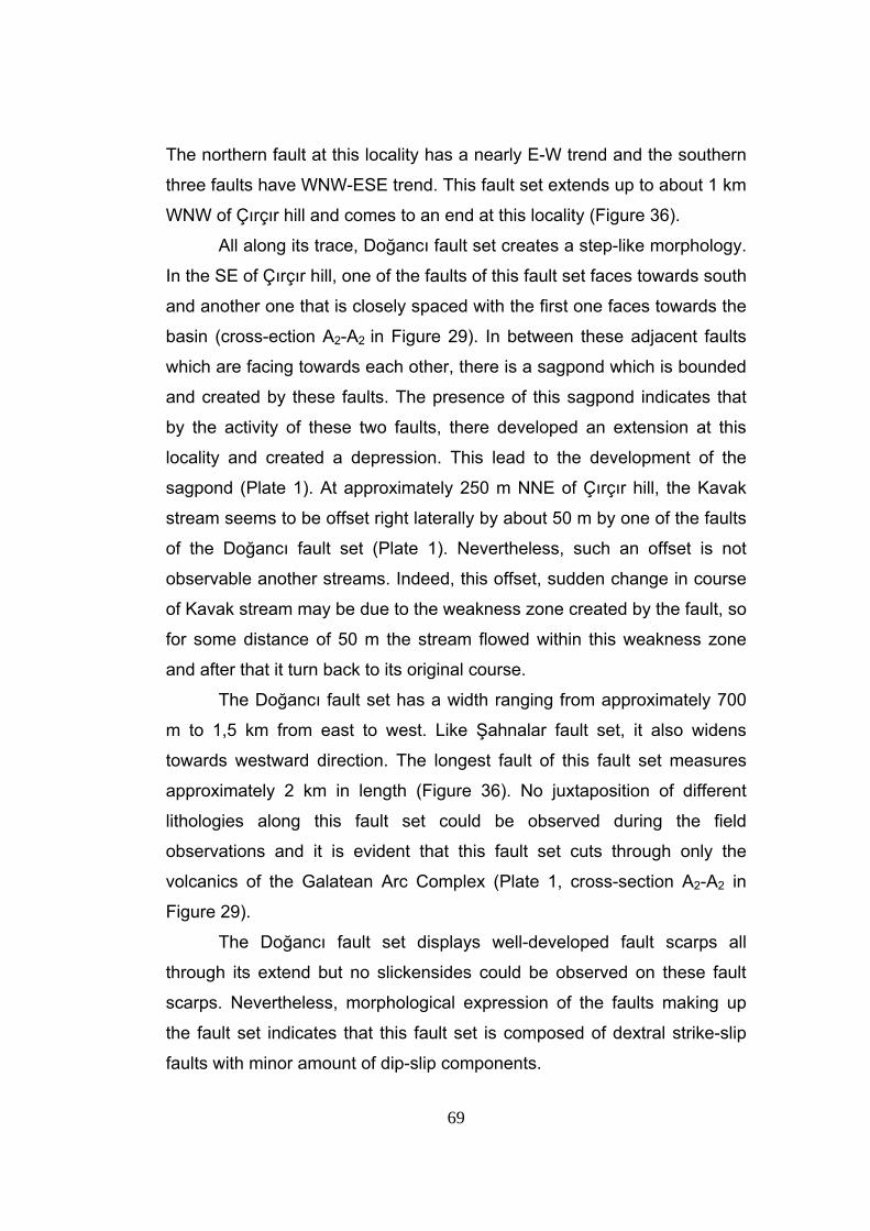
69
The northern fault at this locality has a nearly E-W trend and the southern
three faults have WNW-ESE trend. This fault set extends up to about 1 km
WNW of Çırçır hill and comes to an end at this locality (Figure 36).
All along its trace, Doğancı fault set creates a step-like morphology.
In the SE of Çırçır hill, one of the faults of this fault set faces towards south
and another one that is closely spaced with the first one faces towards the
basin (cross-ection A2-A2 in Figure 29). In between these adjacent faults
which are facing towards each other, there is a sagpond which is bounded
and created by these faults. The presence of this sagpond indicates that
by the activity of these two faults, there developed an extension at this
locality and created a depression. This lead to the development of the
sagpond (Plate 1). At approximately 250 m NNE of Çırçır hill, the Kavak
stream seems to be offset right laterally by about 50 m by one of the faults
of the Doğancı fault set (Plate 1). Nevertheless, such an offset is not
observable another streams. Indeed, this offset, sudden change in course
of Kavak stream may be due to the weakness zone created by the fault, so
for some distance of 50 m the stream flowed within this weakness zone
and after that it turn back to its original course.
The Doğancı fault set has a width ranging from approximately 700
m to 1,5 km from east to west. Like Şahnalar fault set, it also widens
towards westward direction. The longest fault of this fault set measures
approximately 2 km in length (Figure 36). No juxtaposition of different
lithologies along this fault set could be observed during the field
observations and it is evident that this fault set cuts through only the
volcanics of the Galatean Arc Complex (Plate 1, cross-section A2-A2 in
Figure 29).
The Doğancı fault set displays well-developed fault scarps all
through its extend but no slickensides could be observed on these fault
scarps. Nevertheless, morphological expression of the faults making up
the fault set indicates that this fault set is composed of dextral strike-slip
faults with minor amount of dip-slip components.
70
In the study area, the existence and the activeness of the Doğancı
fault set is indicated by the presence of step-like morphology, and the
sudden break in topographical slope, and presence of sagpond along its
extend.
3.2.3.1.7. Yukarı Kuldan Fault Set
Yukarı Kuldan fault set is first named in this study. It controls the
morphology of the southern to southwestern margin of the Yeniçağa Basin
and comprises parallel to nearly orthogonal, curvilinear dextral strike-slip
faults with minor amount of dip-slip components. The fault set is composed
of mainly three faults namely northern, the southern fault and the
orthogonal western segments. In general, the fault set has a NE-SW trend,
but as its trace is highly curvilinear, the trend of the faults of this set
changes from place to place. The fault set starts at approximately 250 m
south of Yukarı Kuldan village and both of the northern and southern faults
have nearly WSW-ENE trend at this locality. Further to the west, both
faults curve towards SW direction and continues in the same manner for
about 600 m. where, the southern strand terminates and the northern
strand curves westward by 400 to gain a E-W trend. Then, towards
westward, it gently bends towards WSW again creating a restraining bend,
and 750 m south of Aşağı Kuldan village it rebends to westward direction.
In the south, 500 m east of the Dağtarla hill, there is another fault which is
relatively short and has a trend of nearly N-S direction; It displays a
relatively linear pattern and possibly joins to the northern fault.
The Yukarı Kuldan fault set displays well-developed step-like
morphology at its eastern parts and characterized by the offset of the
boundary between Soğukçam Limestone – agglomerates of Galatean Arc
Complex (Plate 1). The most evident offset is observed along the N-S-
trending segment of this fault set (Figure 42). This boundary seems to be
offset right laterally by about 400 m along the N-S-trending fault (Plate 1).
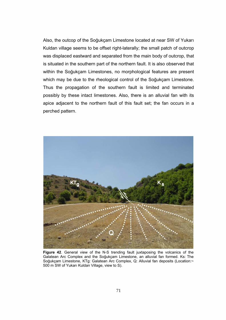
71
Also, the outcop of the Soğukçam Limestone located at near SW of Yukarı
Kuldan village seems to be offset right-laterally; the small patch of outcrop
was displaced eastward and separated from the main body of outcrop, that
is situated in the southern part of the northern fault. It is also observed that
within the Soğukçam Limestones, no morphological features are present
which may be due to the rheological control of the Soğukçam Limestone.
Thus the propagation of the southern fault is limited and terminated
possibly by these intact limestones. Also, there is an alluvial fan with its
apice adjacent to the northern fault of this fault set; the fan occurs in a
perched pattern.
Figure 42. General view of the N-S trending fault juxtaposing the volcanics of the Galatean Arc Complex and the Soğukçam Limestone, an alluvial fan formed. Ks: The Soğukçam Limestone, KTg: Galatean Arc Complex, Q: Alluvial fan deposits (Location:~ 500 m SW of Yukarı Kuldan Village, view to S).
72
The Yukarı Kuldan fault set displays well-developed fault scarps
indicated by the sudden break in slope along its trend.
However, no slickensides could be observed on these scarps. The
morphological expression of the fault set indicates that the Yukarı Kuldan
fault set is made up of dextral strike-slip faults with minor amount of dip-
slip components.
In the study area, the existence and the activeness of Yukarı
Kuldan fault set are indicated by a series of morphological markers such
as sudden break in slope, presence of step-like morphology, juxtaposition
of the Soğukçam Limestone and agglomerates of the Galatean Arc
Complex, and presence of a perched alluvial fan with its apice adjacent to
the northern fault of the fault set.
3.2.3.2. Hamzabey Fault Set
The Hamzabey fault set is first named in this study. It determines
the western margin of the Yeniçağa Basin and comprises NE-SW-
trending linear, closely-spaced basinward-facing dextral strike-slip faults
with minor amount of dip-slip components. The fault set starts at its
junction with the Gerede Fault (Master Strand), and continues towards
northeast as a single fault in a straight pattern up to approximately 1,2 km
ESE of Cevekkeller village, where it jumps to the west and continues for
about 600 m in the same trend up to 500 m NW of Hamzabey village
(Figure 36). In its southwestern parts, a series of alluvial fans with apices
adjacent to the southern margins bounding Hamzabey fault set occur. This
is an indication of sudden break in slope towards the basin located on the
downthrown block of the fault. This fault cuts and displaces the Nallar
thrust fault at approximately 1,2 km SE of Cevekkeller village (Plate 1 and
Figure 40).
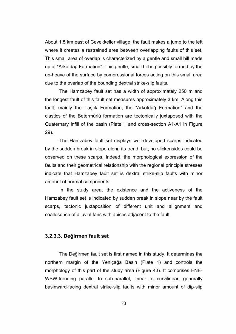
73
About 1,5 km east of Cevekkeller village, the fault makes a jump to the left
where it creates a restrained area between overlapping faults of this set.
This small area of overlap is characterized by a gentle and small hill made
up of “Arkotdağ Formation”. This gentle, small hill is possibly formed by the
up-heave of the surface by compressional forces acting on this small area
due to the overlap of the bounding dextral strike-slip faults.
The Hamzabey fault set has a width of approximately 250 m and
the longest fault of this fault set measures approximately 3 km. Along this
fault, mainly the Taşlık Formation, the “Arkotdağ Formation” and the
clastics of the Betermürlü formation are tectonically juxtaposed with the
Quaternary infill of the basin (Plate 1 and cross-section A1-A1 in Figure
29).
The Hamzabey fault set displays well-developed scarps indicated
by the sudden break in slope along its trend, but, no slickensides could be
observed on these scarps. Indeed, the morphological expression of the
faults and their geometrical relationship with the regional principle stresses
indicate that Hamzabey fault set is dextral strike-slip faults with minor
amount of normal components.
In the study area, the existence and the activeness of the
Hamzabey fault set is indicated by sudden break in slope near by the fault
scarps, tectonic juxtaposition of different unit and allignment and
coallesence of alluvial fans with apices adjacent to the fault.
3.2.3.3. Değirmen fault set
The Değirmen fault set is first named in this study. It determines the
northern margin of the Yeniçağa Basin (Plate 1) and controls the
morphology of this part of the study area (Figure 43). It comprises ENE-
WSW-trending parallel to sub-parallel, linear to curvilinear, generally
basinward-facing dextral strike-slip faults with minor amount of dip-slip
74
components. The longest fault of the fault set starts at approximately 600
m NNE of Müezzinler village and continues in ENE trend.
The shorter faults of this fault set having WSW-ENE trend appear in the
south of the longest fault and bound the pressure ridge located at 750 m
NW of Dumanlar village (Figure 37). The Değirmen fault set terminates in
approximately 1 km west of Gölbaşı village, near by the southern part of
the Çağa Fault (Figure 36).
Figure 43. General view of the northern margin-bounding Değirmen fault set (DFS) and the Hamzaköy thrust fault (HTF). KTa: “Arkotdağ Formation”, Tt: Taşlık Formation, Q: Quaternary deposits (Location: ~ 2 km N of Hamzaköy Village, view to NE)
The longer northern fault segment of the Hamzabey fault set cuts
and displaces the Hamzaköy thrust fault. It indicates that the Hamzabey
fault set fault is younger than the paleotectonic thrust fault (Plate 1).
75
In further east, a very large alluvial fan (~ 2,5 km2), on which Dumanlar,
Sağırlar, Hamzabey and Sirkeliler villages are situated, is bounded by the
longest fault of this fault set at its northeastern area (Figure 36). In the
northern part of this alluvial fan, between two faults of the fault set, that are
dipping in opposite directions, a pressure ridge is present (Figure 37).
The dominant lithology of the this ridge is the red clastics of the Upper
Miocene-Lower Pliocene Eskipazar formation, and the reason for this
pressure ridge to be smooth and rounded may be the rheological property
of this formation. In further east, near its eastern termination point, the
Değirmen fault set comes closer to the Çağa fault and disappears under
the Quaternary units. The longest fault of this fault set is followed through
by the deeply carved Değirmen stream flowing in the valley carved within
the zone of weakness created by the fault itself.
Değirmen fault set has a width of nearly 250 m and the longest fault
of this fault set measures approximately 5 km (Figure 36). Through the
western trace of this fault set, mainly Betemürlü formation and the Taşlık
Formation are tectonically juxtaposed with the “Arkotdağ Formation”. In the
further eastern parts, the Taşlık Formation and the Eskipazar formation
together are tectonically juxtaposed with the Quaternary units and infill of
the Yeniçağa Basin.
The Değirmen fault set’s longest strand displays well-developed
fault scarps all through its extend but no slickensides could be observed
on them. Indeed, the morphological and expression of this fault set
indicate that the fault set comprises dextral-strike slip faults with minor
amount of dip-slip components.
In the study area, the existence and the activeness of Değirmen
fault set is indicated by the sudden break in slope in basinward direction,
presence of deeply carved valley, juxtaposition of different units, presence
of fault-parallel alligned large to extensive alluvial fans and the pressure
ridge with long axis parallel to the margin-bounding faults.
76
3.2.3.4. Çağa Fault
Çağa fault is first named in this study. It controls the morphology of
the northern margin of the Yeniçağa Basin (Figure 44) and comprises
nearly NNE-SSW-trending linear to curvilinear, westward-facing, sinistral
strike-slip fault with minor amount of dip-slip component. It plays an
important role in the evolution of the Yeniçağa Basin.
It starts at approximately 400 m south of Eskiçağa village and runs
towards the south and terminates or disappears under the Quaternary infill
of the Yeniçağa Basin approximately 750 m west of Adaköy (Figure 36).
The Çağa fault has an extraordinary trend relative to the other faults
exposing throughout the study area, and it separates the NW margin of
the basin from its NE margin. In addition to this, it is delineated by the
straight and deeply carved valley of the Çağa River which is carved within
the zone of weakness of this fault (Plate 1).
The length of this fault is approximately 2 km; it juxtaposes mainly
the “Arkotdağ Formation” with the Quaternary infill of the Yeniçağa Basin.
The Çağa fault displays a well-developed fault scarps at localities
where it cuts the “Arkotdağ Formation”. But, no slickensides on this fault
scarps could be observed. Indeed, the morphological expression of the
fault indicates that it is sinistral strike-slip fault with minor amount of dip-
slip component.
In the study area, the existence and the activeness of the Çağa
fault is indicated by the deeply carved Çağa valley, tectonic juxtaposition
of different units and the sudden break in slope.
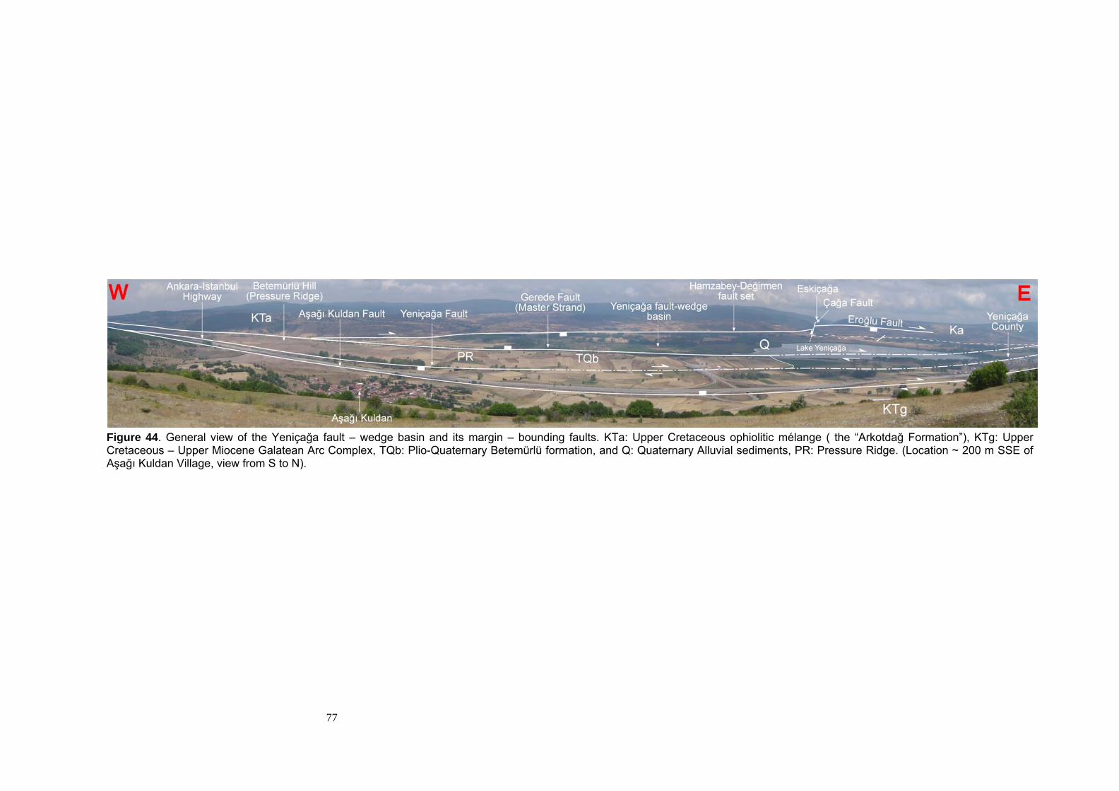
77
Figure 44. General view of the Yeniçağa fault – wedge basin and its margin – bounding faults. KTa: Upper Cretaceous ophiolitic mélange ( the “Arkotdağ Formation”), KTg: Upper Cretaceous – Upper Miocene Galatean Arc Complex, TQb: Plio-Quaternary Betemürlü formation, and Q: Quaternary Alluvial sediments, PR: Pressure Ridge. (Location ~ 200 m SSE of Aşağı Kuldan Village, view from S to N).
78
3.2.3.5. İzmirli Fault Set
This fault zone is first named in this study. It determines the
northeastern to eastern margin of the Yeniçağa Basin (Figure 36) and
comprises linear basinward facing, closely-spaced parallel to sub-parallel,
relatively short and discontinues oblique-slip normal faults with dextral to
sinistral strike-slip component (Plate 1, Figure 36). It starts 500 m SW of
Çamurcuk village, near by the upthrown block of Çağa fault and continues
to the eastward in a nearly WNW-ESE trend until it reaches to the Aksu
fault and, approximately 500 m west of Siyamlar village, it comes to an
end. The faults comprising this fault zone generally trend in NW-SE
direction in the southern parts of the fault zone; however in the northern
parts of the fault zone, the trends of the discontinuous short fault become
nearly E-W. The fault zone passes through İzmirli and Delisüleyman
villages (Plate 1, Figure 36).
The İzmirli fault set displays a step-like morphology all along its
extend as the faults comprising this set are oriented side by side nearly
parallel to each other (Figure 38 and cross-section A3-A3 in Figure 29). The
faults exposed in the west of the set are relatively long and form longer
steps. On the other hand, the faults to the east of the fault set are
relatively short and discontinuous. In the eastern parts, two different trends
are observable. In the northern parts of the fault set, the trends of the
faults are nearly E-W, and these short and discontinuous northern group of
faults comprise dextral strike-slip faults with minor amount of amount of
dip-slip components, and this character is different from any other fault
that is exposed within this fault set. This difference in character is mainly
due to the different orientation of these northern faults with respect to the
orientation of the principle stress axes (Figure 36).
79
The width of the İzmirli fault set differs from place to place and
ranges between 250 m and 1 km. Towards the eastern parts, the fault set
widens and reaches to a width of 1 km (Figure 36). The longest fault of the
İzmirli fault set measures approximately 2 km and the fault zone
juxtaposes mainly the Betemürlü formation and Quaternary infill of the
basin with the “Arkotdağ Formation” (Figure 38).
Faults of the İzmirli fault set displays well-developed scarps
especially in the NE corner of the Yeniçağa Basin. In other parts, fault
scarps are more smoothened and gentle. No slickensides could be found
on these fault scarps but morphological expressions of the faults
comprising the İzmirli fault set indicate that this fault zone comprises
oblique-slip normal faults with minor amount of strike-slip components.
The existence and the activeness of the İzmirli fault set is indicated
by the presence of alluvial fans (Figure 38) with apices adjacent to faults,
sudden break in slope, presence of the Plio-Quaternary perched terrace
conglomerates on downthrown blocks of the faults and tectonic
juxtaposition of different units.
3.2.3.6. Sarayçalı Fault
The Sarayçalı fault is first named in this study. It determines the
northeastern margin of the Yeniçağa and comprises a NE-SW trending,
straight, southeastward-facing, dextral strike-slip fault with minor amount
of dip-slip component. It starts approximately 350 m SSE of Öteköy in the
NE and trends towards SW for about 1,7 km and disppears under the
Quaternary infill of theYeniçağa Basin (Plate 1, Figure 36). Based on the
cross-cutting relationship between this fault and two faults of the İzmirli
fault set exposed nearby the Sarayçalı hill, it can be said that the Sarayçalı
Fault is younger than other two faults of the İzmirli fault set.
80
The length of the Sarayçalı fault is about 1,7 km and it mainly
juxtaposes the “Arkotdağ Formation” with the Quaternary infill of the
Yeniçağa Basin (Plate 1).
The Sarayçalı fault displays well-developed scarp, in places, where
it cuts through the “Arkotdağ Formation”, but no slickensides could be
observed on this scarp. The morphological expression of the fault and its
geometrical relationship with the principle stress indicate that this fault is a
dextral strike-slip fault with minor amount of dip-slip component.
In the study area, the existence and the activeness of the Sarayçalı
fault is indicated by the tectonic juxtaposition of different units and sudden
break in slope towards the basinward direction.
3.2.3.7. Eroğlu Fault
This fault is first named in this study. It controls the morphology of
the northern-northeastern margin of the Yeniçağa Basin (Figure 44). It is a
curvilinear, basinward-facing and, NW-SE- to E-W-trending dextral strike-
slip fault with minor amount of dip-slip component (cross-section A3-A3 in Figure 29). The downthrown of the fault takes place on the southern side
of it. The fault starts approximately 500 m east of Delisüleyman village and
runs towards northwest for about 2,5 km and 750 m southwest of the
Çamlık hill it bends in westward direction, later on it runs in nearly E-W
trend until approximately 250 m northwest of Çamurcuk village where it
comes to end.
The Eroğlu fault meets with another subsidiary fault approximately
500 m southeast of Pısak hill.
The length of the Eroğlu fault is about 4,5 km and it mainly cuts
through the “Arkotdağ Formation”. This fault juxtaposes mainly the Plio-
Quaternary Betemürlü formation and the “Arkotdağ Formation” (Plate 1).
81
The Betemürlü formation is limited generally on downthrown block of this
fault, but in the middle parts of this fault, the Betemürlü formation is not
confined to the downthrown block of the fault, and its exposure extends to
the upthrown block of the fault.
The Eroğlu fault displays smoothened and relatively low fault
scarps. The fault scarps are more evident in the place where the fault
determines the boundary of the outcrops of the Betemürlü formation. No
slickensides could be observed on these fault scarps. On the other hand,
morphological expression of the fault and its geometrical relationship with
the principle stress indicate that the Eroğlu fault is a dextral-strike-slip fault
with minor amount of dip-slip component.
The existence and the activeness of the Eroğlu fault is indicated by
the sudden beak in slope, presence of Plio-Quaternary perched terrace
conglomerates on downthrown block of the fault as well as juxtaposition of
different units.
3.2.3.8. Yamanlar Fault
The Yamanlar fault is first named in this study. The fault controls
the morphology of the northeastern margin of the basin. It is a relatively
straight, E-W-trending, and southward facing dextral strike-slip fault with
minor amount of dip-slip component (Plate 1, Figures 36, 38, 39, and cross-section A3-A3 in Figure 29). It starts approximately 250 m NNW of
Ortaköy and continues eastward for about 3 km. The fault comes to end
approximately 1 km SE of Kınataşı hill (Figure 36).
Morphologically, the fault defines a boundary between northern
higher lands on the upthrown block and southern gently sloping low land
areas on the downthrown block of the fault, and this is best indicated by
the presence of nearly flat-lying, large Plio-Quaternary perched terrace
conglomerates on the hanging block of the fault (Plate 1).
82
The length of the Yamanlar fault is about 3 km and it only cuts
through the “Arkotdağ Formation”. No units are juxtaposed along the trace
of this fault and this is due to the fact that this fault is exposed at a location
relatively far from the active margins of the Yeniçağa Basin (cross-section
A3-A3 in Figure 29).
The Yamanlar fault displays a well-developed fault scarp along its
trend, but no slickensides could be observed on this fault scarp. Indeed,
the morphological expression of this fault indicates that the fault is a
dextral strike-slip fault with minor amount of dip-slip component.
The existence and the activeness of this fault is indicated by the
sudden break in slope and the presence of fault scarp all along its trend.
3.3. Pattern of Neotectonic Structures
The study area is a well-defined zone of deformation dissected by
the closely-spaced strike-slip faults (Figure 36). As shown in Figure 36,
within the zone of deformation, two groups of structures, the transtensional
and the transpressional structures are originated. The sagponds (light blue
area in Figure 36) and the pressure ridges with their axes parallel to the
Gerede Fault (Master Strand) are the transtensional and transpressional
features, respectively.
The whole of the neotectonic structures are superimposed in Figure
36B, which reflects a well-developed right-lateral strike-slip faulting
pattern. By using both the strike-slip fault terminology of Wilcox et al.
(1973) and the Riedel shear terminology modified by Tchalenko &
Ambrasseys (1970), this fault pattern can be interpreted as the Master
fault (Y-shear), the synthetic shear (R), antithetic shear (R’), the secondary
synthetic shear (P) and the extension fracture, or oblique-slip normal
faulting (NF) (Figure 36B).
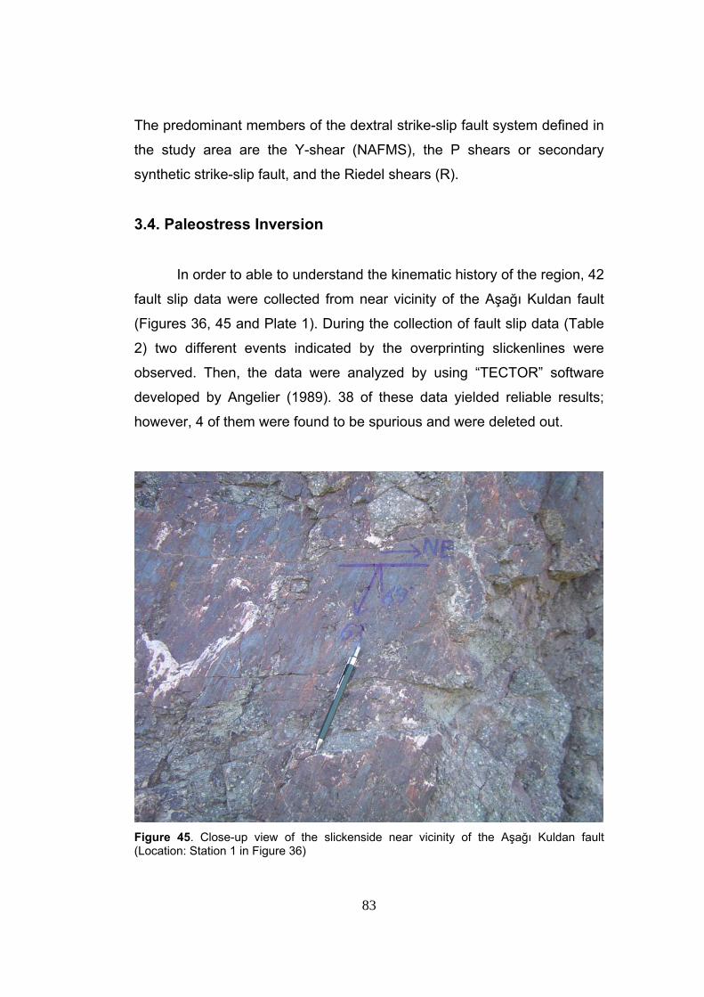
83
The predominant members of the dextral strike-slip fault system defined in
the study area are the Y-shear (NAFMS), the P shears or secondary
synthetic strike-slip fault, and the Riedel shears (R).
3.4. Paleostress Inversion
In order to able to understand the kinematic history of the region, 42
fault slip data were collected from near vicinity of the Aşağı Kuldan fault
(Figures 36, 45 and Plate 1). During the collection of fault slip data (Table
2) two different events indicated by the overprinting slickenlines were
observed. Then, the data were analyzed by using “TECTOR” software
developed by Angelier (1989). 38 of these data yielded reliable results;
however, 4 of them were found to be spurious and were deleted out.
Figure 45. Close-up view of the slickenside near vicinity of the Aşağı Kuldan fault (Location: Station 1 in Figure 36)
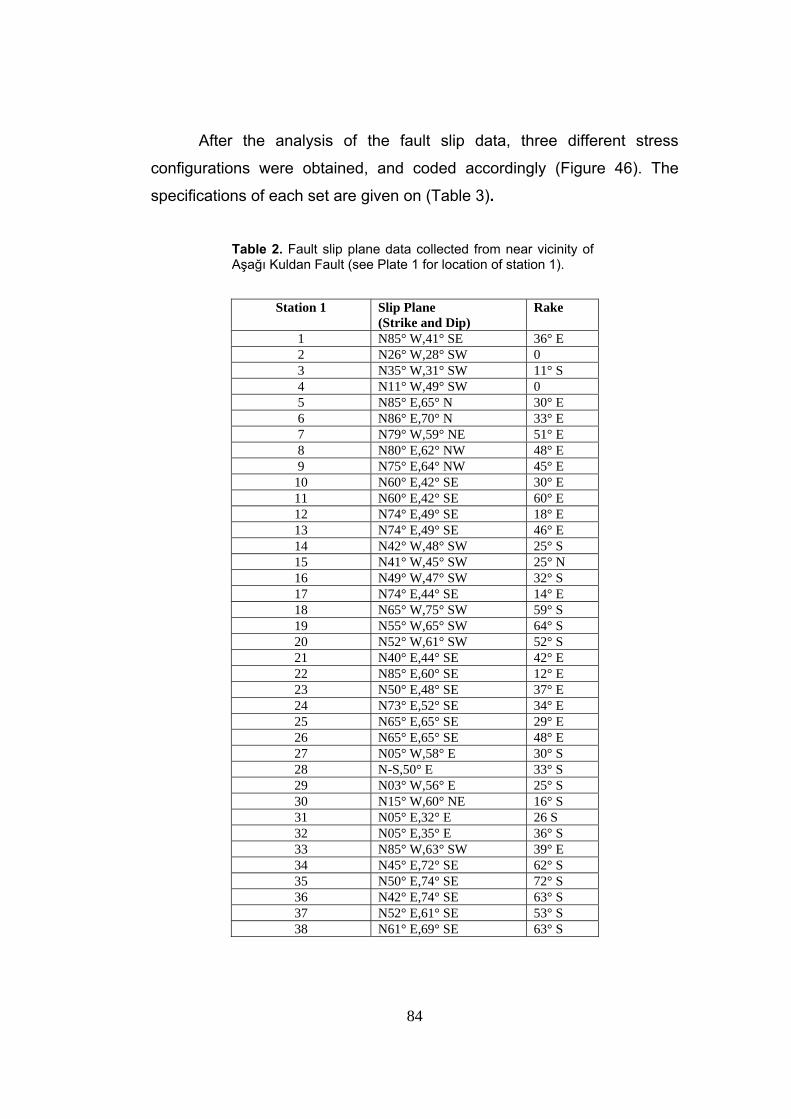
84
After the analysis of the fault slip data, three different stress
configurations were obtained, and coded accordingly (Figure 46). The
specifications of each set are given on (Table 3).
Table 2. Fault slip plane data collected from near vicinity of Aşağı Kuldan Fault (see Plate 1 for location of station 1).
Station 1 Slip Plane (Strike and Dip)
Rake
1 N85° W,41° SE 36° E 2 N26° W,28° SW 0 3 N35° W,31° SW 11° S 4 N11° W,49° SW 0 5 N85° E,65° N 30° E 6 N86° E,70° N 33° E 7 N79° W,59° NE 51° E 8 N80° E,62° NW 48° E 9 N75° E,64° NW 45° E
10 N60° E,42° SE 30° E 11 N60° E,42° SE 60° E 12 N74° E,49° SE 18° E 13 N74° E,49° SE 46° E 14 N42° W,48° SW 25° S 15 N41° W,45° SW 25° N 16 N49° W,47° SW 32° S 17 N74° E,44° SE 14° E 18 N65° W,75° SW 59° S 19 N55° W,65° SW 64° S 20 N52° W,61° SW 52° S 21 N40° E,44° SE 42° E 22 N85° E,60° SE 12° E 23 N50° E,48° SE 37° E 24 N73° E,52° SE 34° E 25 N65° E,65° SE 29° E 26 N65° E,65° SE 48° E 27 N05° W,58° E 30° S 28 N-S,50° E 33° S 29 N03° W,56° E 25° S 30 N15° W,60° NE 16° S 31 N05° E,32° E 26 S 32 N05° E,35° E 36° S 33 N85° W,63° SW 39° E 34 N45° E,72° SE 62° S 35 N50° E,74° SE 72° S 36 N42° E,74° SE 63° S 37 N52° E,61° SE 53° S 38 N61° E,69° SE 63° S
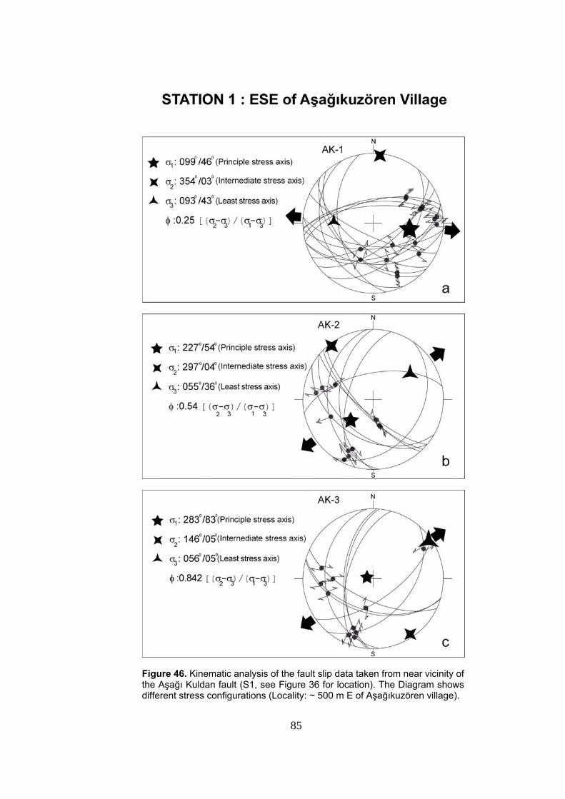
85
Figure 46. Kinematic analysis of the fault slip data taken from near vicinity of the Aşağı Kuldan fault (S1, see Figure 36 for location). The Diagram shows different stress configurations (Locality: ~ 500 m E of Aşağıkuzören village).
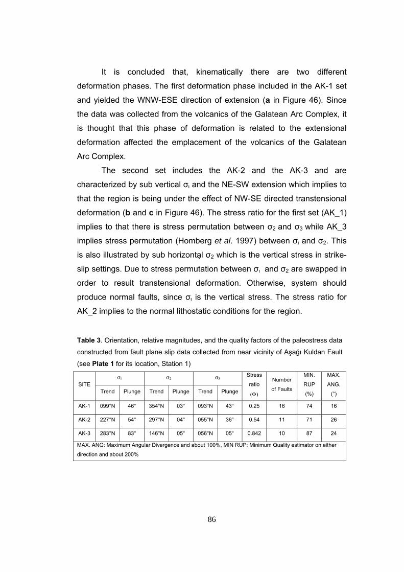
86
It is concluded that, kinematically there are two different
deformation phases. The first deformation phase included in the AK-1 set
and yielded the WNW-ESE direction of extension (a in Figure 46). Since
the data was collected from the volcanics of the Galatean Arc Complex, it
is thought that this phase of deformation is related to the extensional
deformation affected the emplacement of the volcanics of the Galatean
Arc Complex.
The second set includes the AK-2 and the AK-3 and are
characterized by sub vertical σ and the NE-SW extension which implies to
that the region is being under the effect of NW-SE directed transtensional
deformation (b and c in Figure 46). The stress ratio for the first set (AK_1)
implies to that there is stress permutation between σ2 and σ3 while AK_3
implies stress permutation (Homberg et al. 1997) between σ and σ2. This
is also illustrated by sub horizontal σ2 which is the vertical stress in strike-
slip settings. Due to stress permutation between σ and σ2 are swapped in
order to result transtensional deformation. Otherwise, system should
produce normal faults, since σ is the vertical stress. The stress ratio for
AK_2 implies to the normal lithostatic conditions for the region.
Table 3. Orientation, relative magnitudes, and the quality factors of the paleostress data
constructed from fault plane slip data collected from near vicinity of Aşağı Kuldan Fault
(see Plate 1 for its location, Station 1)
σ1 σ2 σ3 SITE
Trend Plunge Trend Plunge Trend Plunge
Stress
ratio
(Φ)
Number
of Faults
MIN.
RUP
(%)
MAX.
ANG.
(°)
AK-1 099°N 46° 354°N 03° 093°N 43° 0.25 16 74 16
AK-2 227°N 54° 297°N 04° 055°N 36° 0.54 11 71 26
AK-3 283°N 83° 146°N 05° 056°N 05° 0.842 10 87 24
MAX. ANG: Maximum Angular Divergence and about 100%, MIN RUP: Minimum Quality estimator on either
direction and about 200%
87
CHAPTER 4
DISCUSSION AND CONCLUSION
One of the main aims of this thesis is to explain the neotectonic
evolution of the Yeniçağa Basin.
5.1. Evolution of the Yeniçağa Basin
New structural and stratigraphic data presented in the previous
foregoing chapters have allowed us to refine the age chronology and
reconstruct the neotectonic evolution of the Yeniçağa Basin. This basin
displays two phases of evolution, indicated by the outcrop patterns of
latest paleotectonic unit, namely the Eskipazar formation, the Plio-
Quaternary deposits of the Betemürlü formation and the Upper Quaternary
basin fill. The spatial distribution of these units within and surrounding the
basin gives an idea about the evolutionary pattern of the basin.
The latest paleotectonic unit, the Eskipazar formation, displays two
distinct phases of deformation. The lower part of the Upper Miocene –
Lower Pliocene Eskipazar formation is characterized by outcrop – scale
growth faults and conjugate fractures. Their kinematic analysis yielded
NW-SE directed extension and indicated that extensional tectonic regime
was prevailing during the formation of these syn-depositional shear
fractures and growth faults (Figure 31). During the Late Miocene – Early
Pliocene time interval, the Eskipazar formation was actively being
deposited in a paleotectonic basin that is formed by the NW-SE directed
extension as indicated by the widespread presence of growth faults and
shear fractures all through the Eskipazar formation (Figure 30).
88
The second phase of deformation took place after Early Pliocene and all
the sequence of Eskipazar formation underwent a NE-SW directed
compression and got folded with axes of folds trending NW-SE
perpendicular to the maximum compression direction (σ1) (Figures 34 and
35). As a result of this compression the paleotectonic fill of the basin
uplifted with the surrounding areas and it got thinner and thinner by
erosion. These deformation and erosional activity distorted the
configuration of the paleotectonic basin and with the onset of the
neotectonic period this paleotectonic basin got abandoned. During the
initial stages of the neotectonic period the Yeniçağa Basin started to
develop in the northern parts with respect to the present position of the
active basin, which is indicated by the widespread outcrops of the Plio-
Quaternary Betemürlü formation. Nevertheless, in the following stages of
the neotectonic period the on-going strike-slip deformation in the study
area led to the development of the active Yeniçağa Basin relatively in the
southern part and abandoned the basin formation in the south.
With the formation of the North Anatolian Fault System and onset of
the neotectonic regime, several basins formed along the NAFS with their
long axes parallel to the general trend of the NAFS and thus, nearly
trending E-W. These basins are indeed, formed due to the strike-slip
complexities along the NAFS and considered to be purely strike-slip
basins. The Yeniçağa Basin is also a purely strike-slip basin with its long
axis trending nearly E-W direction.
The present configuration of the Yeniçağa Basin suggests that this
basin is a nearly E-W trending purely strike-slip fault wedge basin (Figures
47, 48).
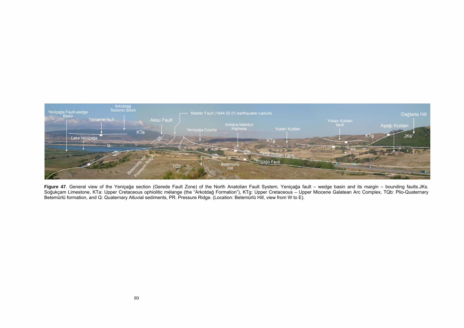
89
Figure 47. General view of the Yeniçağa section (Gerede Fault Zone) of the North Anatolian Fault System, Yeniçağa fault – wedge basin and its margin – bounding faults.JKs. Soğukçam Limestone, KTa: Upper Cretaceous ophiolitic mélange (the “Arkotdağ Formation”), KTg: Upper Cretaceous – Upper Miocene Galatean Arc Complex, TQb: Plio-Quaternary Betemürlü formation, and Q: Quaternary Alluvial sediments, PR. Pressure Ridge. (Location: Betemürlü Hill, view from W to E).
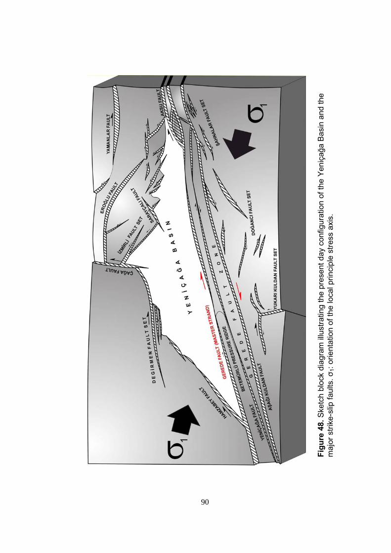
90
Figu
re 4
8. S
ketc
h bl
ock
diag
ram
illu
stra
ting
the
pres
ent d
ay c
onfig
urat
ion
of th
e Y
eniç
ağa
Bas
in a
nd th
e m
ajor
stri
ke-s
lip fa
ults
. σ1:
orie
ntat
ion
of th
e lo
cal p
rinci
ple
stre
ss a
xis.
91
5.2. Conclusions
In the light of above mentioned discussion and the newly gathered
field and laboratory data presented in the foregoing chapters, the
followings are concluded;
Based on the analysis of data gathered during the field studies and
geological mapping of the study area at 1/25.000 scale the Yeniçağa
Basin is interpreted to be a purely strike-slip fault wedge basin.
In this study, the neotectonic characteristics of the Yeniçağa Basin
are studied in detail. Indeed, neotectonic characteristics of this basin have
never been studied in such a detailed way previously by any scientists.
This study was focused on the neotectonic characteristics of the
Yeniçağa Basin. However, one of the main aims of this study was to figure
out the evolutionary history of the basin and for this purpose the latest
paleotectonic unit exposing within the study area was also considered in
detail. Results of the analysis of the slip plane data gathered from the syn-
depositional shear fractures and growth faults of this unit indicated that it
had experienced NW-SE directed extension during Late Miocene – Early
Pliocene time interval, under the control of an extensional paleotectonic
regime. In addition, the analysis of the trend of fold axes of this unit
showed that, the extensional paleotectonic regime was than succeeded by
a compressional paleotectonic regime as a last phase of paleotectonic
period. Related NE-SW directed compressional deformation resulted in
folding of the latest paleotectonic infill with fold axes trending in NW – SE
direction.
Geologically active nature of the faults, exposing within the study
area is indicated by the down cutting of streams, development o marginal
92
alluvial fans, well preserved fault scarps, fault terraces and presence of
master strand of the NAFS passing through the basin.
The morphological expressions of the faults and their geometrical
relationships with the principal stresses indicate that these faults, exposing
within the study area are generally strike-slip faults with normal
components and oblique-slip normal faults.
Most of the settlements are located on water saturated, loose flood
plain deposits forming the basin infill (Plate 1). Therefore, these
settlements are open to earthquake hazard. Best solution of this problem
is to construct structures at suitable places outside of loose, water
saturated Quaternary basin fill and major active faults.
93
REFERENCES
Ach, J.A., 1982, The Petrochemistry of the Ankara Volcanics, Central Turkey,
MSc Thesis, State University of New York at Albany, USA.
Akyol, E., 1969, Ankara-Kızılcahamam-Çeltikçi Civarında Bulunan Kömür
Zuhurlarının 1:25 000 Ölçekli Detay Jeolojik Etüdü Hakkında Rapor,
General Directorate for Mineral Research and Exploration (MTA),
Report No. 4405 [in Turkish].
Akyürek, B., Bilginer, E., Akbaş, B., Hepşen, N., Pehlivan, S., Sunu, D.,
Soysal, Y., Değer, Z., Çatal, E., Sözen, B., Yıldırım, H., Hakyemez,
Y., 1984, Ankara – Elmadağ – Kalecik dolayının temel jeoloji
özellikleri, Jeoloji Mühendisliği Dergisi 20: 21–46 [in Turkish with
English abstract].
Altınlı, İ.E., 1973b, Bilecik Jurasiği, Cumhuriyetin 50.yılı Yerbilimleri Kongresi,
Tebliğler, 159-191.
Altıner, D., Koçyiğit, A., Farinacci, A., Nicosia, U., Conti, M.A., 1991, Jurassic-
Lower Cretaceous Stratigraphy and Paleogeographic Evolution of
the Southern Part of North-Western Anatolia, Turkey, Geologica
Romana, 27, 13-80.
Ambraseys, N.N., Finkel, C.F., 1987, Seismicity of Turkey and neighbouring
regions, 1899-1915, Annales Geophysicae, 87, 701-725.
94
Ambraseys, N.N., Finkel, C.F., 1987, The Anatolian Earthquake
of 17 August 1668, In: Lee, W.H.K.,Meyers, H. and Shimazaki,
K. (eds.), Historical Seismograms and Earthquakes of the World,
Academic Press, San Diego, pp. 173–180.
Ambraseys, N.N., Finkel, C.F., 1995, The Seismicity of Turkey and Adjacent
Areas: A Historical Review,1500-1800, Eren Yayıncılık, İstanbul,
240p
Ambraseys, N.N., Jackson, J.A., 1998, Faulting associated with historical and
recent earthquakes in the Eastern Mediterranean region,
Geophysical Journal International, 133, 390-406.
Angelier, J., 1989, Data Base For Tectonic Orientations "Tector"
Version 5.42, aug87-oct88-dec88-aou89 Copyright 1987,1988,1989.
Barka, A., 1984, Kuzey Anadolu Fay Zonundaki Bazı Neojen-Kuvaterner
Havzalarinin Jeoloji ve Tektonik Evrimi, Ketin Simpozyumu, 209-227.
Barka, A., Hancock, P.L., 1984, Neotectonic deformation patterns in the
convex-northwards arc of the North Anatolian Fault Zone, In: Dixon,
J.E. Robertson, A.H.F. (Eds.), The Geological Evolution of the
Eastern Mediterranean. Geol. Soc. London, Special Pub., 17, 763-
774.
95
Barka, A.A., Gülen, L., 1988, New constraints on age and total offset of the
North Anatolian Fault Zone: Implications for tectonics of the Eastern
Mediterranean Region, In “1987 Melih Tokay Sympozyumu” . Spec.
Publ. Middle-East Techn. University, Ankara, Turkey, 39-65.
Bozkurt, E., 2001, Neotectonics of Turkey, Geodinamica Acta, 14, 3-30.
Canıtez, N., Üçer B., 1967, A catalogue of focal mechanism diagrams for
Turkey and adjoining areas, Istanbul Technical University, 25,
Istanbul.
Canıtez, N., 1973, Yeni kabuk hareketlerine ilişkin çalışmalar ve Kuzey
Anadolu Fay problemi, Kuzey Anadolu Fayı ve Deprem Kuşağı
Simpozyumu. MTA Yayınları, Ankara, 35-58.
Canıtez, N., Büyükaşıkoğlu, S., 1984, Seismicity of the Sinop Nuclear Power
Plant Site, Final Report, İstanbul Teknik Üniversitesi, İstanbul.
Çakır, Z., Barka, A.A., Chabalier, J.B., Armijo, R., Meyer, B., 2003,
Kinematics of the November 12, 1999 (Mw =7.2) Düzce Earthquake
Deduced from SAR interferometry, Turkish Journal of Erath
Sciences, 12, 105-118.
Erinç, S., Bilgin, T., Bener, M., 1961, Çağa Depresyonu ve Boğazı, İstanbul
Üniversitesi Coğrafya Enstitüsü Dergisi, 6, 7-31.
96
Ergin, K., Güçlü, U., Uz, Z., 1967, Türkiye VE Civarının Deprem Kataloğu
(Milattan sonar 11 Yılından 1964 Sonuna Kadar), [An Earthquake
Catalogue for Turkey and its Surroundings for the interial 11-1964]
İstanbul Teknik Üniversitesi, Maden Fakültesi, Arz Fiziği Enstitüsü
Yayınları 24, 169 p [in Turkish].
Erol, O., 1951, Ayaş Dağları ve Mürted Ovasının Kuzey Bölümü Hakkında
Rapor, General Directorate for Mineral Research and Exploration
(MTA), Report No. 2456 [in Turkish].
Erol, O., 1954, Ankara ve Cıvarının Jeolojisi Hakkında Rapor, General
Directorate for Mineral Research and Exploration (MTA), Report
No.2491 [in Turkish].
Erol, O., 1955, Köroğlu-Işıkdağlari Volkanik Kütlesinin Orta Bölümleri ile
Beypazarı-Ayaş Arasındaki Neojen Havzasının Jeolojisi Hakkında
Rapor, General Directorate for Mineral Research and Exploration
(MTA), Report No. 2279 [in Turkish].
Fourquin, C., Paicheler, J.C., Sauvage. J., 1970, Premiers donne´s sur la
stratigraphie dumassif galate d’ andesites: etude palynologique de
las base des diatomsMioce´enes de Beşkonak au NE Kızılcahamam
(Anatolie, Turque), Comptes rendus de l’academie des Sciences,
Paris 270: 2253–2259.
Gökten, E., Özaksoy, V., Karakuş, K., 1996, Tertiary volcanics and tectonic
evolution of the Ayaş-Güdül-Çeltikçi region, International Geology
Review 38: 926–934.
97
Hempton, M.R., 1987, Constraints on Arabian plate motion and extensional
history of the Red Sea: Tectonics, 6, 687-705.
Homberg, C., Hu, J.C., Angelier, J., Bergerat, F., and Lacombe, O., 1997
Characterization of stress perturbations near major fault zones:
insights from 2-D distinct-element numerical modeling and field
studies (Jura Mountains). Journal of Structural Geology, 19/5, 703-
718.
Kahle, H.G., Straub, C., Reilinger, R., McClusky, S., King, R., Hurst, K., Veis,
G., Kastens, K., Cross, P., 1998, The strain rate field in the eastern
Mediterranean region, estimated by repeated GPS measurements,
Tectonophysics, 294, 237-252.
Kahle, H.G., Cocard, M., Peter, Y., Geiger, A., Reilinger, R., Barka, A., Veis,
G., 2000, GPS- derived strain rate field within the boundary zones of
the Eurasian, African and Arabian plates, Journal of Geophysical
Research,105, 23353-23370
Kazanci, N., Gökten, E., 1988, Lithofacies features and tectonic environments
of the continental Paleocene volcanoclastics in Ankara region,
METU Journal of Pure and Applied Sciences 21: 271–282.
Keller, J., Jung, D., Eckhardt, F.J., Kreuzer, H., 1992, Radiometric ages and
Chemical characterization of the Galatean andesite massif, Pontus,
Turkey, Acta Vulcanologica 2: 267–276.
98
Koçyiğit, A., 1984, Güneybatı Türkiye ve yakın dolayında levha içi yeni
Tektonik gelişim, Geological Society of Turkey Bulletin, 27, 1-16.
Koçyigit, A., 1988, Basic geologic characteristics and total offset of the North
Anatolian Fault Zone in Suşehri area, NE Turkey, METU Pure Appl.
Sci., 22, 43–68.
Kocyigit, A., 1989, Susehri basin: an active fault-wedge basin on the North
Anatolian Fault Zone, Turkey, Tectonophysics, 167, 13-29.
Koçyigit, A., 1990, Tectonic setting of the Gölova basin, total offset of the
North Anatolian Fault Zone, Eastern Pontide, Turkey, Annales
Tecton., 4, 155–170.
Koçyiğit, A., 1991a., An example of an accretionary forearc basin from
northern Central Anatolia and its implications for history of
subduction of Neo-Tethys in Turkey, Geological Society of America
Bulletin 103: 22–36.
Koçyiğit, A.,1991b, Changing stress orientation in progressive intracontinental
deformation as indicated by the Neotectonics of the Ankara region
(NW Central Anatolia), Turkish Association of Petroleum Geologists
Bulletin 3: 45–48.
Koçyigit, A., 1996, Superimposed Basins and Their Relations to the Recent
Strike-Slip Fault Zone : A case Study of the Refahiye Superimposed
Basin Adjacent to the North Anatolian Transform Fault, Northeastern
Turkey, International Geology Review, 4, 701-713.
99
Koçyiğit, A., Beyhan, A., 1998, A new intracontinental transcurrent structure:
the Central Anatolian Fault Zone, Turkey, Tectonophysics 284: 317–
336.
Koçyiğit, A., Yılmaz, A., Adamia, S., Kuloshvili, S., 2001a, Neotectonics of
East Anatolian Plateau (Turkey) and Lesser Caucasus: implication for
transition from thrusting to strike-slip faulting, Geodinamica Acta, 14,
177-195.
Koçyiğit, A., Rojay, B., Cihan, M., Özacar, A., 2001b, The June 6, 2000, Orta
(Çankırı, Turkey) earthquake: source from a New Anthithetic Sinistral
Strike-Slip Structure of the North Anatolian Fault System (NAFS), The
Dodurga Fault Zone, Turkish Journal of Earth Sciences, 10, 69-82.
Koçyiğit, A., Winchester, J.A., Bozkurt, E., Holland, G., 2003a, Saraçköy
Volcanic Suite: implications for the subductional phase of arc
evolution in the Galatean Arc Complex, Ankara, Turkey, Geological
Journal, 38, 1-14.
Koçyiğit, A., Ayhan, E., Demir, C., Lenk, O., Açıkgöz, M., Fırat, O., Çetin,H.,
Aytun, A., Günaydın, O., Biryol, C.B., Arca, M.S., 2003b, Kuzey
Anadolu Fay Sisyeminin (KAFS) İsmetpaşa – Gerede ve Mengen
arasındaki kesiminin depremselliği, 3. altı aylık gelişme raporu, The
Scientific and Technical Research Council of Turkey (TÜBİTAK)
Project, No. YDABAG 102- Y- 053, 20 p [unpublished, in Turkish].
Lahn, E., 1948, Türkiye Göllerinin Jeolojisi ve Jeomorfolojisi Hakkında bir
Etüd, General Directorate for Mineral Research and Exploration
(MTA), Seri B, 12, 19 p.
100
Le Pichon, X., Angelier, J., 1979, The Hellenic arc and trench system: a key
to the neotectonic evolution of the eastern Mediterranean area,
Tectonophysics, 60, 1-42.
McClusky, S., Balassanian, S, Barka, A. Demir, C., Ergintav, S., Georgiev,
İ,Gurkan, 0., Hamburger, M., Hurst, K., Kahle, H., Kastens, K.,
Kekelidze, G., King, R., Kotzev, V., Lenk, O., Mahmoud, S., Mishin,,,
A., ,Nadariya, M Ouzounis, A., Paradissis, D., Peter, Y., Prilepin, M.,
Reilinger, R., Sanli, I., Seeger, H., Tealeb, A., Toksoz, M. N., Veis, G.
2000. Global Positioning System constraints on plate
kineniatics and dynamics in the eastern Mediterranean and
Caucasus, Journal of Geophysical Research,105, B3, 5695-5719.
McKenzie, D.P., 1972, Active tectonics of the Mediterranean region,
Geophysical Journal Astron. Soc., 55, 217-254.
Meulenkamp, J.E., Wortel, M.J.R., Van Wamal, W.A., Spakman, W.,
Hoogerduyn Strating, E., 1988, On the Hellenic subduction zone and
the geodynamic evolution of Crete since the late Middle Miocene,
Tectonophysics, 146, 203-215
North, R., 1974, Seismic slip rates in the Mediterranean and Middle East.,
Nature, 252, 560-563.
The North American Commission on Stratigraphic Nomenclature Reprinted,
1983, The American Association of Petroleum Geologists Bulletin,
67, No.5, 841-875.
101
Okay, A.İ., Şahintürk, O., 1997, Geology of the Eastern Pontides. In Regional
and Petroleum Geology of the Black Sea and Surrounding Region,
Robinson AG (ed.). American Association of Petroleum Geologists
Memoirs 68: 291–311.
Öngür, T., 1977, Volcanologic and petrologic study of the SW Kızılcahamam,
Geological Society of Turkey Bulletin 20: 1–12 [in Turkish with
English abstract].
Öztürk, A., İnan, S., Tutkun S.Z., 1984, Abant-Yeniçağ (Bolu) yöresinin
stratigrafisi, C.Ü. Mühendislik Fakültesi Yer Bilimleri Dergisi, 1, 1-18.
Öztürk A., İnan, S., Tutkun S.Z., 1985, Abant-Yeniçağa (Bolu) Bölgesinin
Tektoniği, Cumhurivet Üniversitesi Müh. Fak., Yerbilimleri Dergisi,
Seri A, 2, 33-50.
Perinçek, D., Günay, Y., Kozlu, H., 1987, Güneydoğu Anadolu Bölgesindeki
yanal atımlı faylar ile ilgili yeni gözlemler, in Türkiye 7. Petrol
Kongresi, 6-10 Nisan 1987, Ankara, Bildiriler, 89-103.
Ramsey, J.G., 1967, Folding and Fracturing of Rocks, McGraw-Hill Book
Company, New York, 560 p.
Reilinger, R.E., McClusky, S.C., Oral, M.B., King, W., Toksöz, M.N., 1997,
Global Positioning System measurements of present-day crustal
movements in the Arabian–Africa-Eurasia plate collision zone, J.
Geophy. Res. 102, 9983–9999.
102
Royden, L., 1993, Evolution of retreating subduction boundaries formed
during continental collision, Tectonics, 12, 303-325.
Serdar, H.S., Uğur, M.Ş., 1990, Mengen – Bolu – Abant – (Bolu ili) dolayının
jeolojisi ve petrol olanakları, Turkish Petroleum Corporation (TPAO),
Report No. 1989 [in Turkish].
Soysal, H., Sipahioğlu, S., Koçak, D., Altinok, Y., 1981, Türkiye ve Çevresinin
Tarihsel Deprem Kataloğu (M.Ö. 2100-M.S. 1900) [A Historical
Earthquake Catalogue for Turkey and its Surrounding – 2100 BC to
1900]. Scientific and Technical Research Council of Turkey Project,
No. TBAG 341, 87 p [unpublished, in Turkish].
Stchepinsky, V., Lahn, E., 1941, Ankara-Çankırı-Gerede Arasındaki Mıntıka
Hakkında Rapor, General Directorate for Mineral Research and
Exploration (MTA), Report No. 1312 [in Turkish].
Stein, R.S., Barka, A.A., Dieterich, J.H., 1997, Progressive failure on the
North Anatolian fault since 1939 by earthquake stress triggering,
Geophys. J. Inter., 128, 594–604.
Şaroğlu, F., 1988, The age and offset on the North Anatolian Fault, METU J.
Pure Appl. Sci. 21, 65–79.
Şaroğlu, F., Herece, E., Emre, Ö., Sarıaslan, M., 1995, Yeniçağa-Gerede-
Eskipazar arasının jeolojisi ve Kuzey Anadolu Fayı’nın genel
özellikleri, General Directorate for Mineral Research and Exploration
(MTA), Report No. 9873 [in Turkish].
103
Şengör, A.M.C., 1980, Türkiye’nin neotektoniğinin esasları, Türkiye Jeoloji
Kurultayı Konferans Serisi, No.2, 40p.
Şengör, A.M.C., Yılmaz, Y., 1981, Tethyan evolution of Turkey: a plate
tectonic approach, Tectonophysics 75: 181–241.
Şengör, A.M.C., Görür, N., and Şaroğlu, F., 1985, Strike-slip faulting and
related basin formation in zones of tectonic escape: Turkey as a
case study, in Strike-Slip Deformation, Basin formation and
Sedimentation, eds Biddle, K.T. and Christie-Blick, N., Soc. Econ.
Paleon. Mineral. Tulsa, spec. Publ., 37, 227-264.
Tankut, A., Akiman, O., Türkmenoğlu, A., Güleç, N., Göker, T.T., 1990,
Tertiary volcanic rocks in Northwest-Central Anatolia, In IESCA 1990
Proceedings 2, Savaşçın, Y., Eronat, A.H., (eds). 450–466.
Tatar, Y., 1978, Tectonic study of the Erzincan-Refahiye section of the North
Anatolian Fault Zone, Hacettepe Univ. Earth Sci., 4, 201–236 (in
Turkish with English abstract).
Tchalenko, J.S., Ambraseys, N.N., 1970, Structural analysis of the Dasht-e
Bayaz (Iran) earthquake fractures, Geol. Soc. Am. Bull., 81, 41-60.
Tokay, M., 1973, Kuzey Anadolu Fay Zonunun Gerede ile Ilgaz arasındaki
kısmında jeolojik gözlemler, Kuzey Anadolu Fayı ve Depremler
Kuşağı Simpozyumu Tebliğleri, M.T.A. Enstitüsü Ankara, 12-29.
Toprak, V., Savaşçın Y, Güleç, N., Tankut, A., 1996, Structure of the
Galatean volcanic province, International Geology Review 38: 747–
758.
104
Türkecan, A., Hepşen, N., Papak, I., Akbaş, B., Dinçel, A., Karataş, S., Özgür,
I., Akay, E., Bedi, Y., Sevin, M., Mutlu, G., Sevin, D., Ünay, E.,
Saraç, G., 1991, Seben-Gerede (Bolu), Güdül-Beypazarı (Ankara)
ve Çerkeş-Orta-Kurşunlu (Çankırı) Yörelerinin (Köroğlu Dağları)
Jeolojisi ve Volkanik Kayaçların Petrolojisi, General Directorate for
Mineral Research and Exploration (MTA), Report No. 9193 [in
Turkish].
Wilcox, R.E., Harding, T.P., Seely, D.R., 1973, Basic wrench tectonics, Am.
Ass. Petrol. Geol. Bull., 57, 74-96.
Wilson, M., Tankut, A., Güleç, N., 1997, Tertiary volcanism of the Galatia
province, north-west Central Anatolia, Turkey. Lithos 42: 105–121.
Yiğitbaş, E., Elmas, A., 1997, Bolu-Eskipazar Zonu’nun jeolojisi; Intra-Pontid
Sütur Zonu’nun gelişimine bir yaklaşım, Geosound, 30, 1-13 [in
Turkish].
Yiğitbaş, E., Elmas, A., 2001, Ophiolite emplacement by strike-slip tectonics
between the Pontide Zone and the Sakarya Zone in northwestern
Anatolia, Turkey, Int. J. Earth Sciences (Geol Rundsch), 90, 25-269.
Yücel, N., 1969, Jeoteknik Hizmetler ve Yeraltısuları Dairesi Başkanlığı Su
Sondaj Kuyu Logu, DSİ Genel Müdürlüğü, No. 13629/A, 1-2.
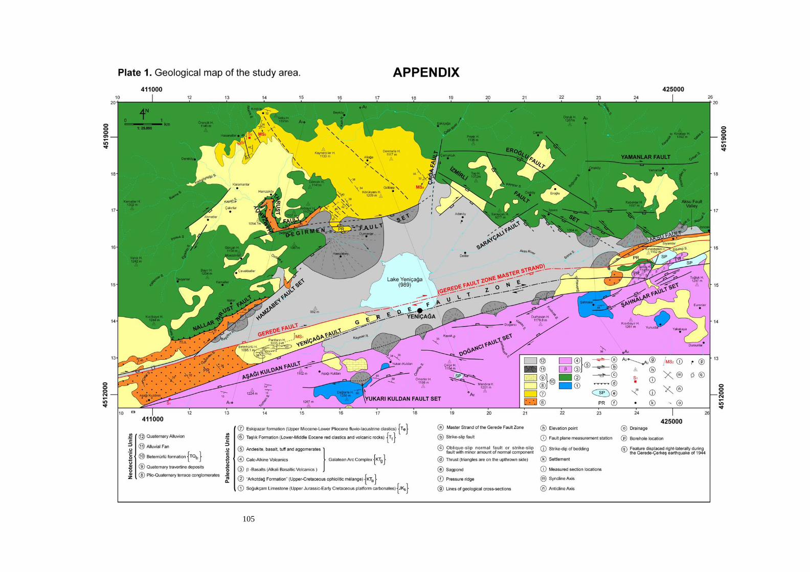
105