Embed Size (px)
Citation preview

Journal of Asian Earth Sciences 45 (2012) 57–64
Contents lists available at SciVerse ScienceDirect
Journal of Asian Earth Sciences
journal homepage: www.elsevier .com/locate / jseaes
Neodymium isotopic variations of the late Cenozoic sediments in the JianghanBasin: Implications for sediment source and evolution of the Yangtze River
Lei Shao a,b, Chang’an Li a,c,⇑, Shengyuan Yuan a,b, Chunguo Kang b,d, Jietao Wang a, Ting Li e
a Faculty of Earth Sciences, China University of Geosciences, Wuhan 430074, Chinab State Key Laboratory of Geological Processes and Mineral Resources (GPMR), China University of Geosciences, Wuhan 430074, Chinac Key Laboratory of Biogeology and Environmental Geology of Ministry of Education, Wuhan 430074, Chinad Institute of Geophysics & Geomatics, China University of Geosciences, Wuhan 430074, Chinae Hubei Earthquake Administration, Wuhan 430074, China
a r t i c l e i n f o
Article history:Received 13 April 2011Received in revised form 8 September 2011Accepted 19 September 2011Available online 25 September 2011
Keywords:Yangtze RiverJianghan BasinNd isotopeProvenance
1367-9120/$ - see front matter � 2011 Elsevier Ltd. Adoi:10.1016/j.jseaes.2011.09.018
⇑ Corresponding author at: Faculty of Earth ScGeosciences, Wuhan 430074, China.
E-mail addresses: [email protected], chanli@cu
a b s t r a c t
The Yangtze River originates from eastern Asia and is one of the most important components of the EastAsia river system. In this study we applied bulk Nd isotopic analysis to identify the sediment provenancein the Jianghan Basin, middle Yangtze River and tried to provide useful information on the evolvement ofthe Yangtze River. The fine-grained (<0.058 mm) sediment samples were selected from a continuousborehole in the Jianghan Basin and analyzed for Nd isotopic compositions. The 143Nd/144Nd ratios varybetween 0.512042 and 0.512239, with an average of 0.512144. The eNd(0) values vary between �11.6and �7.8, with an average of �9.6. Nd isotopic compositions cannot provide compelling evidence toprove whether the Pliocene sediments in the Jianghan Basin were influenced by the source rocks inthe Jinshajiang area characterized by extremely high (positive) eNd(0) values. While these source rocksmade a great contribution to the Jianghan Basin during the Quaternary. Less negative eNd(0) values reflectpreferential erosion of source rocks in the Jinshajiang drainage. The Nd variations reflected changes inerosion patterns during the Quaternary. Based on the provenance analysis of the Jianghan Basinsediments, we propose that the Yangtze River appears to develop into a large river similar as the modernYangtze no later than the beginning of the Quaternary.
� 2011 Elsevier Ltd. All rights reserved.
1. Introduction
The major river systems in eastern Asia transport a large quan-tity of terrestrial materials eroded from the Tibetan into the mar-ginal seas and have been highlighted for many years (Brookfield,1998; Clift et al., 2004, 2006, 2008a,b; Liang et al., 2008). Besidesthe marginal seas, some sedimentary basins e.g. the Jianghan Basin(Fig. 1) also receive large amount of sediments transported bythese large rivers. Thus they are considered as important linkagebetween the continents and the oceans (Clift et al., 2004; Wang,2004; Zheng and Jia, 2009). Understanding the evolvement of theselarge rivers is important to understanding the process of orogeny.The uplift of the mountains and plateaus where these large riversoriginate are proposed to profoundly affect the global climate sys-tem (An et al., 2001). Consequently the reconstructions of theserivers are important to understand the global change and its regio-nal response (Wang, 2004).
ll rights reserved.
iences, China University of
g.edu.cn (C. Li).
The Yangtze River is one of the major rivers in the world (Chenet al., 2001). Originating from the Tibetan Plateau, the river flowseastward across the three major topographic levels. Its drainagecovers more than one-fifth of the continental area of China beforefinally entering the East China Sea. Although study of the evolve-ment of the Yangtze River has a long history of more than100 years, it is still controversial. Previous studies proposed thatthe Yangtze River can be dated back to the Cretaceous or the earlyTertiary (Clark et al., 2004; Clift et al., 2006, 2008b; Jia et al., 2010;van Hoang et al., 2009), the early Quaternary (Fan et al., 2005; Kanget al., 2009; Yang et al., 2006; Zhang et al., 2008) or the latePleistocene (Brookfield, 1998).
Clark et al. (2004) proposed that the Yangtze River was once thetributary of the so called ‘‘paleo-Red River’’ draining into the SouthChina Sea and reorganized by sequential river capture and reversalevents. The Nd evolution in the Hanoi Basin showed that the middleYangtze (downstream the First Bend) was once important source tothe paleo-Red River and was lost from the paleo-Red River between37 and 24 Ma (Clift et al., 2006). Nd, Pb data and U–Pb dating and Hfisotope analysis of zircons support the paleo-drainage pattern thatthe Songpan-Garze terrain once belonged to the paleo-Red drainagebasin and was gone before 12 Ma or maybe much earlier (Clift et al.,

Fig. 1. Location of the Jianghan Basin and the Zhoulao Borehole (modified after Yang et al. (2007a), Zhang et al. (2008)). (A) A sketch of Chinese tectonic units. (B) The Yangtzedrainage basin with the location of the Sichuan Bain and Jianghan Basin. (C) Simplified geological map of the Jianghan Basin and the location of the Zhoulao Borehole. SC andJH denote the Sichuan Bain and Jianghan Basin respectively.
58 L. Shao et al. / Journal of Asian Earth Sciences 45 (2012) 57–64
2006, 2008b; van Hoang et al., 2009). However no compelling evi-dence for the connection between the upper Yangtze (upstreamthe First Bend) and the paleo-Red River were found, but their datado not preclude this possibility (van Hoang et al., 2009). Recentlymany important researches based on the theory of ‘‘source to sink’’have been carried out in the Yangtze delta to reconstruct the evolu-tion history of the Yangtze River. These authors used the elementalcompositions (Huang et al., 2009; Yang et al., 2006, 2007b), isotopiccompositions (Yang et al., 2007b), and age patterns of monazite(Fan et al., 2005; Yang et al., 2006) and zircon (Jia et al., 2010) totrace the source of the late Cenozoic sediments in the Yangtze delta.Their researches provided direct evidence of evolution of theYangtze River and showed that the wide Yangtze drainage basinsimilar as today’s dimension was formed mainly at the beginningof the Quaternary. Compared with the Yangtze Delta, the prove-nance study of the late Cenozoic sediments in the Jianghan Basin,another depocenter of the Yangtze sediment were not sointegrated.
The Nd isotope has been proved to be rarely influenced byweathering, sediment transport and deposition process (Goldsteinet al., 1984). Thus the Nd isotopic compositions in sedimentary ba-sin reflect the average composition of the source rocks that wereproviding materials at the sedimentation time. If a source with dif-ferent isotopic character is gained or lost from the drainage then itwill induce a measurable change in the Nd isotopic composition ofthe sediments carried by river (Clift et al., 2006). Based on this, theNd isotope can be a reliable tool for tracing the source of sedi-ments. Many ‘‘Source to Sink’’ researches have been carried outbased on the Nd isotopic compositions (Clift et al., 2006; Singhet al., 2008; Yang et al., 2007a,b). Changes in eNd values have beenwell suited to defining sediment provenance in the Red River sys-tem e.g. the Nd isotopic change of sediments of the Hanoi Basin can
be well associated with some important drainage capture of withinthe paleo-Red River system (Clift et al., 2006). Yang et al. (2007a)reported the Nd isotopic composition of the suspended particulateand fine-grained floodplain sediments of the Yangtze River system,which showed that the Nd variations primarily reflect the controlof source rocks such as the Himalayanian and Yesannian graniterocks and the Emeishan basalt in the upper valley and the sedi-mentary and low-grade metamorphic rocks in the middle and low-er valleys.
In this paper we report the Nd isotopic compositions of the lateCenozoic sediments of the Jianghan Basin for the first time. Themain objective is to identify the provenance change of the lateCenozoic sediments of the Jianghan Basin. Based on that, we tryto figure out the changing patterns of erosion of the Yangtze Riversystem and provide more constraints on the evolution of the Yan-gtze River.
2. Yangtze River system
2.1. River setting
The huge Yangtze drainage basin is more than 6300 km inlength and has a catchment area of 1.8 � 106 km2. It is located be-tween 24�270–35�440N and 90�330–122�190E. The Yangtze drainagebasin spans the regional structure of China with three-grade reliefand can be divided into three parts, the upper, middle and lowerreaches. The upper Yangtze is from the source area to Yichangand has a total drainage area of about 100 � 104 km2. Within theupper Yangtze, the section from the source area to Yibin is usuallycalled the Jinshajiang. The Jinshajiang is jointed by the Yalongjiangat Panzhihua. The river section from Yibin to Fengjie is the so called
L. Shao et al. / Journal of Asian Earth Sciences 45 (2012) 57–64 59
Chuanjiang, which is jointed by three major tributaries: the Minji-ang, Jialingjiang and Wujiang. The famous Three Gorges reach isfrom Fengjie to Yichang which is composed of Qutang Xia, WuXia abd Xiling Xia (Xia means Gorge). The middle Yangtze is fromYichang to Hukou, jointed by the Dongting Lake drainage basin,Hanjiang and Poyang Lake drainage basin. Below the Hukou, sev-eral large interior lakes, such as the Chaohu Lake and Taihu Lakein association with many tributaries, drain into the lower YangtzeRiver.
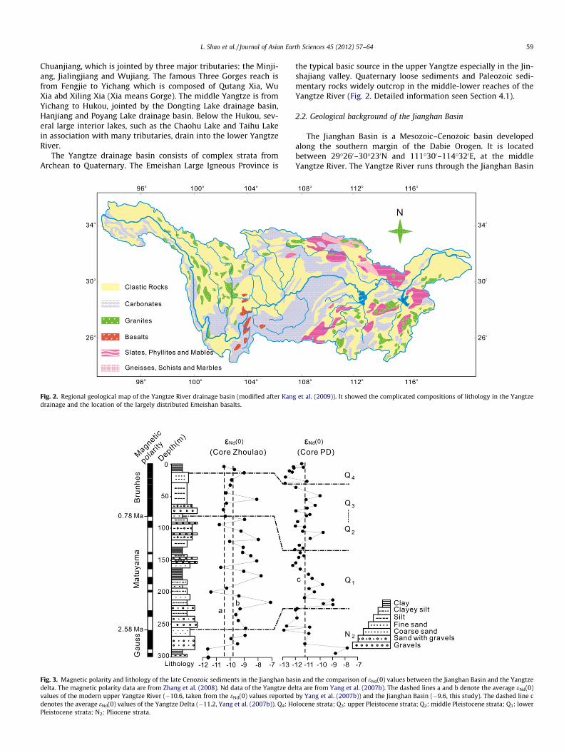
The Yangtze drainage basin consists of complex strata fromArchean to Quaternary. The Emeishan Large Igneous Province is
Fig. 2. Regional geological map of the Yangtze River drainage basin (modified after Kangdrainage and the location of the largely distributed Emeishan basalts.
Fig. 3. Magnetic polarity and lithology of the late Cenozoic sediments in the Jianghan basdelta. The magnetic polarity data are from Zhang et al. (2008). Nd data of the Yangtze devalues of the modern upper Yangtze River (�10.6, taken from the eNd(0) values reporteddenotes the average eNd(0) values of the Yangtze Delta (�11.2, Yang et al. (2007b)). Q4: HoPleistocene strata; N2: Pliocene strata.
the typical basic source in the upper Yangtze especially in the Jin-shajiang valley. Quaternary loose sediments and Paleozoic sedi-mentary rocks widely outcrop in the middle-lower reaches of theYangtze River (Fig. 2. Detailed information seen Section 4.1).
2.2. Geological background of the Jianghan Basin
The Jianghan Basin is a Mesozoic–Cenozoic basin developedalong the southern margin of the Dabie Orogen. It is locatedbetween 29�260–30�230N and 111�300–114�320E, at the middleYangtze River. The Yangtze River runs through the Jianghan Basin
et al. (2009)). It showed the complicated compositions of lithology in the Yangtze
in and the comparison of eNd(0) values between the Jianghan Basin and the Yangtzelta are from Yang et al. (2007b). The dashed lines a and b denote the average eNd(0)by Yang et al. (2007b)) and the Jianghan Basin (�9.6, this study). The dashed line clocene strata; Q3: upper Pleistocene strata; Q2: middle Pleistocene strata; Q1: lower

60 L. Shao et al. / Journal of Asian Earth Sciences 45 (2012) 57–64
from west to east. Tectonic frameworks of the Jianghan Basin arecontrolled by two groups of tensional normal faults lying NNWand EW respectively. The basin has subsided ever since the lateCretaceous (Zhang, 1994). Such a geological controlled basin isfavorable to siltation (Yin et al., 2007). It is an important catchmentbasin where a great amount of materials are deposited from theupper Yangtze. With continuous deposit for a long time especiallyever since the late Cenozoic, the Jianghan Basin provides idealmaterials for the reconstruction of the evolvement of the YangtzeRiver.
2.3. Late Cenozoic sediments in Core Zhoulao
The continuously drilled core (Core Zhoulao) was taken fromthe Qianjiang Depression, Jianghan Basin. Zhang et al. (2008) re-ported the magnetic stratigraphic framework of Core Zhoulaowhich has been the best magnetic stratigraphic column of the Jian-ghan Basin so far. The Brunhes/Matuyama boundary (�0.78 Ma)and Matuyama/Gauss (�2.58 Ma) boundary were located at thedepths of 82 m and 260 m respectively (Fig. 3). Besides severalpolarity subepoches were identified. The Jaramillo (0.99–1.07 Ma)and Olduvai (1.77–1.95 Ma) normal polarity subepoch were lo-cated at the depths of 90–100 m and 154.99–164.37 m respec-tively, while the Reunion normal polarity subepoch (2.14–2.15 Ma) was located at the depth of 178.69–185.07 m. Based onthe magnetic stratigraphy, the time framework of the Core Zhoulaocan be established.
The final drilling depth of the Core Zhoulao was 300.49 m, withthe average recovery of 85%. The Quaternary strata of the JianghanBasin primarily consist of fluvial facies interbedded with lacustrinefacies and comprise several major fining-upward and coarsening-upward sediment sequences (Zhang et al., 2008).
3. Sampling and methodology
Thirty-five samples were collected from the borehole sedi-ments. Fine-grained clastic sediments can best reflect the averagecomposition of the large source area, so only the fine fraction(<0.058 mm) was selected for the determination of Nd isotopiccomposition. The <0.058 mm fine fraction was washed to removesalts and sieved from the bulk sediments using a 250-mesh sievein deionized water and dried at room temperature in a clean oven.Then the dried samples were grounded into powder <200 meshand prepared for the Nd isotope measurement.
Table 1Nd isotopic compositions of the late Cenozoic sediments in the Jianghan Basin. Notes: eNd(0isotopic composition.
Depth (m) Samples 143Nd/144Nd 2r eNd(0)
5.4 6-1 0.512102 5 �10.510.0 9-1-1-B 0.512139 3 �9.715.0 13-1 0.512179 1 �9.026.0 21-1 0.512130 6 �9.934.0 25-2 0.512125 6 �10.046.0 32-1 0.512109 6 �10.356.0 39-1-1 0.512223 28 �8.162.0 42-2-1 0.512111 3 �10.372.0 48-1 0.512099 5 �10.582.0 53-1-1 0.512107 3 �10.487.0 55-1-1 0.512178 3 �9.095.0 59-2-1 0.512085 4 �10.8
105.0 65-3-1 0.512165 3 �9.2118.0 72-1-1 0.512229 7 �8.0121.0 73-2-1 0.512123 3 �10.0130.0 77-1 0.512173 4 �9.1138.0 82-1-1 0.512171 2 �9.1143.0 84-1-1 0.512201 4 �8.5
The Nd isotope experiments were carried out at the State KeyLaboratory of Geological Processes and Mineral Resources (GPMR),China University of Geosciences using a Finnigan Triton ThermalIonization Mass Spectrometer (TIMS) according to the method pre-sented by previous study (Ling et al., 2009). An aliquot of 0.1 gpowders of each sample were measured and digested by Teflonbombs using mixed agents of HNO3 and HF acids at 190 �C for72 h. Element Nd was separated and purified in a super clean lab-oratory using ion exchange columns of Dowex AG50WX12 cationresin and Eichrom Ln-Spec resin successively. Isotope ratios of143Nd/144Nd were normalized to 146Nd/144Nd = 0.721900. Measure-ment of standard La Jolla gives average value of 0.511847 ± 3 (2rexternal standard deviation, n = 25).
The eNd(0) values were calculated using 143Nd/144Nd value of0.512638 for the Chondritic Uniform Reservoir (Hamilton et al.,1983).
4. Results and discussions
4.1. 143Nd/144Nd and eNd(0) variations of the late Cenozoic sedimentsin the Jianghan Basin and the Nd isotopic compositions of the potentialsource rocks
The Nd variations are listed in Table 1. The 143Nd/144Nd ratios ofthe <58 lm fractions range from 0.512042 to 0.512239, with anaverage of 0.512144. The corresponding eNd(0) values vary be-tween �11.6 and �7.8, with an average of �9.6 (Table 1 andFig. 3). The in-depth analysis of the Nd variations revealed thatsediments from the Core Zhoulao below the depth of 280.0 m showthe lowest eNd(0) values around �11.6 which is obviously lowerthan the average of the sediments from the Core Zhoulao and theaverage of the modern upper Yangtze mainstream (�10.6 was ta-ken to represent the average eNd(0) values of the upper Yangtzemainstream as reported by Yang et al. (2007a)). eNd(0) values ofsediments between the depth of 280 m and 220 m are relativelystable and higher than the modern upper Yangtze. eNd(0) valuesof the sediments from the depth of 220 m upward till 82 m (theend of the early Pleistocene) are characterized by drastic fluctua-tions and several extremely positive values around �8.0. Ever sincethe mid-Pleistocene, sediments showed eNd(0) values around�10.6 which is close to the modern upper Yangtze mainstream, ex-cept one sample with eNd(0) value of �8.1.
The Nd isotopic compositions can only be used as provenanceindicator when the different Nd isotopic compositions between
) = ((143Nd/144Nd)Measured/(143Nd/144Nd)CHUR � 1) � 104, is the normalized present-day
Depth (m) Samples 143Nd/144Nd 2r eNd(0)
151.0 87-2-1 0.512223 3 �8.1161.0 91-2-1 0.512090 5 �10.7167.0 94-1-1 0.512175 3 �9.0174.0 96-3-1 0.512239 4 �7.8193.0 104-2-1 0.512112 9 �10.3199.0 106-3-1 0.512051 25 �11.4205.0 109-1-1 0.512157 4 �9.4215.0 112-3-1 0.512273 23 �7.1225.0 116-2-1 0.512160 5 �9.3234.0 119-3-1 0.512144 24 �9.6243.0 123-2-1 0.512155 4 �9.4255.0 127-3-1 0.512182 4 �8.9266.0 131-3-1 0.512180 6 �8.9271.0 133-2-1 0.512128 5 �9.9279.0 136-1-1 0.512152 8 �9.5287.0 139-1-1 0.512042 8 �11.6300.0 142-4-1 0.512044 11 �11.6

Fig. 4. Nd isotopic compositions of the Pliocene and Quaternary sediments in the Jianghan Basin, main tributaries of the Yangtze River and possible source terrains. The Nddata are from Yang et al. (2007a), Wu et al. (2010), Meng et al. (2008), Xiao et al. (2003), Zhang and Wang (2003), Wei et al. (2003), Zhu et al. (2003), Chen et al. (2006), Zhanget al. (2007) and Gao et al. (1999).
L. Shao et al. / Journal of Asian Earth Sciences 45 (2012) 57–64 61
the potential sources exist. The source rocks in the Yangtze drain-age basin are complicated including Archean metamorphic rocks,Paleozoic carbonate and sedimentary rocks, Mesozoic–Cenozoicigneous and clastic rocks, and Quaternary detrital sediments (Yanget al., 2007a). However according to the Nd isotopic compositionsof these source rocks (Fig. 4), potential source of the sediments ofthe Jianghan Basin can be divided into three parts.
4.1.1. First, proximal area around the Jianghan Basin and the ThreeGorges area
Quaternary loose sediments widely outcrop in the Jianghan Ba-sin and its surrounding area. Isotopic researches of these loose sed-iments have been rarely reported, except the Kongling Terrainwhich are associated with strongly negative eNd(0) values varyingbetween �36.0 and �13.2 (Gao et al., 1999). Sediments from maintributaries of the middle Yangtze such as Qingjiang, Hanjiang,Yuanjiang and Xiangjiang showed negative eNd(0) values rangingfrom �15.3 to �11.0 (Meng et al., 2008; Yang et al., 2007a).
4.1.2. Second, source rocks in the Chuanjiang drainage basinThe Chuanjiang rivers such as the Minjiang and Jialingjiang,
drain the eastern flank of the plateau and are inferred to supplysignificant sediments to the Yangtze River (Changjiang Water Re-source Commission, 2008). Detailed information has been ex-tracted by the Ar–Ar muscovite data (van Hoang et al., 2010) andthe 10Be budget (Chappell et al., 2006) that the Longmenshan areais the most important sediment supplier to the Chuanjiang Riversediments. The Longmenshan range constitutes the eastern borderof the Tibetan Plateau. It is characterized by a steep topographictransition from the Sichuan Basin to the plateau. Triassic flyshand Neoproterozoic-Permian passive margin sediments widelyoutcrop. Previous studies showed that these materials are associ-ated with eNd(0) values ranging from �16.5 to �9.1, with an aver-age of �12.7 (Chen et al., 2006; Zhang et al., 2007). Furthermore,Permian basalts with high eNd(0) values (Zi et al., 2008) can alsobe the possible basic sources of sediments.
4.1.3. Third, the Jinshajiang drainage basinMost source rocks in this area are characterized by high (less
negative) eNd(0) values. The Emeishan large igneous provincewidely distributes at the west margin of the Yangtze Craton. Itoccupies an area over 250,000 km2 and is one of the most impor-tant igneous provinces in the world (Xiao et al., 2004). The Emei-
shan basalts are characterized by the strongly positive eNd(0)values varying from �9.0 to 3.3 with an average of �2.5 (Xiaoet al., 2003,2004; Zhang and Wang, 2003). As pointed by Yanget al. (2007a), it is suffered strongly chemical weathering underthe influence of humid and warm climate and thus should havemuch influence on the Nd isotopic composition of the river sedi-ments. Besides, the Permian ophiolites and volcanic rocks areabundant in the Jinshajiang area. These rocks are associated withhigh eNd(0) values from �1.8 to +6.9 (Wei et al., 2003), erosionfrom these rocks can also make important contribution to the Ndisotopic composition of the downstream (Wu et al., 2010). Wuet al. (2010) reported three samples of Jinshajiang showed thatthey had high eNd(0) values ranging from �9.4 to �8.5.
Generally the eNd(0) values of the source rocks become less neg-ative (higher) from the proximal area of the Jianghan Basin to theJinshajiang area (Fig. 4). This is confirmed by the fact that theeNd(0) values of the middle Yangtze River sediments are obviouslylower than those of the upper reaches (Yang et al., 2007a).
Nd isotope has a long history of application for provenance dis-crimination. The difference of Nd isotopic compositions of the endmembers and the successful application of Nd isotopes to con-straining the provenance of sediments of the Yangtze River (Yanget al., 2007a,b) suggest that this method is appropriate for con-straining sources of sediments in the Jianghan Basin. Here we syn-thesize our data with the Nd values of the late Cenozoic sedimentsof the Yangtze delta reported by Yang et al. (2007b) to generate acomplete image of Nd isotopic variation in the Jianghan Basin anddecipher some useful information on the changing patterns of ero-sion and the understanding of the evolution of the Yangtze River.
4.2. Provenance discrimination and changing patterns of erosion
Studies of magnetism parameters and heavy mineral character-istics revealed that sediments in the Jianghan Basin were derivedfrom the proximal area before the Yangtze River was formed (Kanget al., 2009; Zhang et al., 2008). After the Yangtze drain pattern be-came as large as its modern dimension, large amount of debriswere eroded from the upper basin and deposited at the JianghanBasin. Sediment flux analysis reveals that most of the sedimentof the modern Yangtze River is derived from the upper basin (Chenet al., 2001). As mentioned above, these sediments from distalsources could dominate Nd isotopic compositions of the JianghanBasin. Similar phenomena also exist at the Yangtze delta.

62 L. Shao et al. / Journal of Asian Earth Sciences 45 (2012) 57–64
Significant and large variations of Nd ratio not only occur at thedepth of 280 m (close to the boundary of Pliocene and Quaternarystrata), but also within the lower Pleistocene sediments and be-tween the middle and upper Pleistocene sequences. In comparison,the upper Pleistocene sediments and Holocene sediments have rel-atively small variations in Nd ratio. Because the magnetic polaritycannot provide accurate age, we consider that the sedimentary ageof sediments at the depth of 280 m was no later than the beginningof the Quaternary. Combined with the observation of the sedimentlithology, it shows that the significant Nd isotopic variations couldnot be well correlated with particular sediment lithology or itsvariation. Even among sediments with same characters, significantNd isotopic variations still exist. Thus the possibility that these Ndisotopic variations were caused by changing sediment characterscould be excluded. Nd isotopic compositions of sediments havebeen proved to be rarely influenced by depositional process(Goldstein et al., 1984). So changing sediment provenance shouldbe the only factor that could induce the Nd isotopic variations ofthe sediments in the Jianghan Basin. Sediments at the bottom(280 m below) of the core show much more negative values thanthe overlying sediments, which should be indicative of more inputfrom older, radiogenic continental crust. As discussed above, prox-imal area of the Jianghan Basin and the tributaries in the middleYangtze River are both associated with strongly negative eNd(0)values. It seems that these source rocks should made importantcontributions to the Jianghan Basin. However source rocks in theChuanjiang drainage area are also capable of supplying sedimentswith similar Nd isotopic compositions (Fig. 4). This makes Nd a lesspowerful provenance tool for these sediments. It cannot providecompelling evidence to prove whether these sediments in the Jian-ghan Basin were influenced by the source rocks in the Jinshajiangarea characterized by extremely high (positive) eNd(0) values.
In contrast, eNd(0) values of sediments above the depth of 280 mare much more positive, which should be associated with more in-put from primitive crust. As mentioned above, the first part (280–220 m) shows stable isotopic values around �9.5 which indicate astable provenance. The eNd(0) values are obviously higher than thesource rocks known from the Chuanjiang and middle Yangtzedrainage basin and indicate significant input from sources witheNd(0) values higher than �9.5. That means the source rocks dis-tributed in the Jinshajiang drainage are expected to be an impor-tant contributor to the sediment flux.
From the early Pleistocene to the beginning of the mid-Pleisto-cene, sediments in the Jianghan Basin received more inputs ofprimitive crust as revealed by the higher eNd(0) values. It couldbe associated with the mantle-derived upper Permian–TriassicEmeishan basalt. The Emeishan LIP covers a large area over250,000 km2 in the upper Yangtze valley. It could be an importantsupplier of sediments to the Yangtze River and thus can have muchinfluence on the Nd isotopic compositions (Yang et al., 2007a). Be-sides, the Cenozoic volcanic rocks are also exposed in the Jinshaji-ang area. These rocks are also characterized by high eNd(0) valuesand thus could possibly make contributions to the Yangtze Riversediments (Zhu et al., 2003). Furthermore, during this period theNd variations were fluctuant and indicate that provenance of thesediments were not stable. Ever since the mid-Pleistocene, prove-nance of the sediments have stayed stable and been similar to themodern Yangtze River especially the upper Yangtze. Heavy mineralresearch of the Jianghan Basin sediments revealed that the sedi-ments after 1.1 Ma show stable heavy mineral compositions weresimilar as the modern Yangtze River (Kang et al., 2009). Besides,magnetism parameters characters of these sediments were alsosimilar to the modern Yangtze River (Zhang et al., 2008). These re-searches argue that the provenance of the sediments in the Jian-ghan Basin have been the same as the modern upper YangtzeRiver since 1.1 Ma, which are similar to our research. However,
those data could not show the provenance change before 1.1 Ma.It suggests that the Nd isotopic compositions could provide muchmore informations for the provenance of the sediments in the Jian-ghan Basin.
Generally, source area of sediments of the Jianghan Basin mightbecome as large as the modern ones no later than the beginning ofthe Quaternary. However, patterns of erosion were not totally thesame during different stages of the Quaternary. Nd isotopic varia-tions of the sediments in the Yangtze Delta also revealed that ero-sion patterns of the Yangtze River changed during different stagesof the Quaternary (See Section 4.4).
According to the division of the source area, sediments in theJianghan Basin mainly derive from three end-members. The contri-butions from the surrounding area of the Jianghan Basin shouldsignificantly decrease after the Yangtze River was finally formed.It can be supported by the fact that most of the sediment of themodern Yangtze River is derived from the upper basin (Chenet al., 2001). Based on that, we can make reasonable assumptionthat the change of erosion rates in the Chuanjiang drainage and Jin-shajiang drainage would significantly induce the Nd variations ofthe sediments in the Jianghan Basin. The patterns of erosion maybe correlated with climate-tectonic coupling. Previous studies re-vealed that erosion rates are governed by crustal deformation, cli-mate or both of them (Beaumont et al., 2001; Burbank et al., 2003;Clift, 2010; Zhang et al., 2001). The southeastern part of the TibetanPlateau experienced rapid deformation during the late Cenozoic(Wang and Burchfiel, 2000). Besides, topography falls rapidly onthe edges of the Tibetan Plateau, fast erosion could be expectedin this area during the Cenozoic. Previous studies showed that highexhumation rates at the Longmen Shan area began at the end of theCenozoic (Arne et al., 1997; Clark et al., 2005; Godard et al., 2009;Kirby et al., 2002), while the comparison of zircon and apatite agesindicated that the eastern part of the Longmen Shan range mighthave experienced a significant decrease in exhumation since 2–3 Ma (Godard et al., 2009). Thus decreasing input from the Long-menshan area could be expected and would indirectly induce theincreasing proportion of inputs from the Jinshajiang area. In thatcase, Nd values of the Yangtze sediments would become more po-sitive. The relatively unstable Nd variations revealed the unstablepatterns of erosion in the upper Yangtze drainage basin duringthe early Pleistocene. Ever since the mid-Pleistocene, the stableNd variations of the Jianghan Basin indicated stable pattern of ero-sion in the source area.
In particular, the middle Pleistocene–Holocene sediments havemore negative Nd ratios than the lower Pleistocene sediments. Weargue that it was due to the increasing input from the Longmen-shan area. Ar–Ar muscovite data (van Hoang et al., 2010) and the10Be budget (Chappell et al., 2006) reveal that the Longmenshanarea is the most important sediment supplier to the modern Yan-gtze River sediments. As shown by the Nd isotopic variations ofthe source rocks, source rocks in the Longmenshan area show morenegative Nd ratios than the Jinshajiangjiang basin, thus, theincreasing input from the this area could lead the Nd ratios ofthe sediments to become more negative.
4.3. Comparison with the Yangtze Delta
Yang et al. (2007b) reported the Nd isotopic variations of thelate Cenozoic sediments in the Yangtze Delta (Fig. 3), eNd(0) valuesof which vary between �12.9 and �7.8, with an average of �11.2.eNd(0) values of the late Cenozoic sediments in the Jianghan Basinare relatively higher than the Yangtze Delta, indicating that thesource rocks with low eNd(0) values in the middle and lower Yan-gtze did exert a significant influence on the Yangtze delta. Based onthe 10Be data, Zheng et al. (2005) assumed that sediments from theeast Yangtze could account for 17–40% of the sediments in the Yan-

L. Shao et al. / Journal of Asian Earth Sciences 45 (2012) 57–64 63
gtze Delta. The Nd variations in the Yangtze Delta seem to be morecomplicated than those in the Jianghan Basin, especially since themid-Pleistocene. As revealed by Nd variations in the Jianghan Ba-sin, patterns of erosion in the upper Yangtze were stable ever sincethe mid-Pleistocene. Meanwhile Nd variations in the Yangtze deltawere characterized by several periodic changes (Yang et al.,2007b). It indicates that provenance of the sediments in the Yan-gtze Delta changed periodically. During this period, the differentNd variations between the Jianghan Basin and the Yangtze Deltarevealed that the provenance change of the Yangtze Delta actuallyindicated the changing patterns of erosion in the middle and lowerYangtze. Patterns of erosion in the Yangtze River drainage basinwere different during different stages of the Quaternary. Even atthe same time, they were still different in different reaches. How-ever, sediment sources of both the Jianghan Basin and the YangtzeDelta have been stable ever since the late Pleistocene. It indicatesthat patterns of erosion in the whole Yangtze reaches have beenstable since then.
4.4. Implications for the evolution of the Yangtze River
The Nd data cannot provide compelling evidence for the prove-nance of the Pliocene sediments. We cannot confirm whether thesesediments in the Jianghan Basin were influenced by the sourcerocks in the Jinshajiang area characterized by extremely high (po-sitive) eNd(0) values. As the result, we do not know that whetherthe sharp changes in the Nd isotope compositions at the depth of280 m was caused by river geometry or the changing erosion pat-terns. However the Nd isotope compositions do suggest that theQuaternary sediments were considerably influenced by distalsource rocks with high eNd(0) values, including the Emeishan bas-alts (Fig. 4). Our borehole does not go deep enough, so it cannotprovide more details on the river evolution history before, i.e. therelationship between the paleo-Yangtze and the paleo-Red. Sowe conclude that the Yangtze drainage basin extended to theupper valley including the Emeishan LIP and developed into a largeriver as the same dimension as the modern Yangtze River no laterthan the beginning of the Quaternary. What needed to be declaredis that we do not try to prove a young birth to the Yangtze River,we just conclude that the birth of the Yangtze River should predatethe beginning of the Quaternary. Provenance studies of the lateCenozoic sediments in the Yangtze Delta suggest that the Yangtzebecame a large river extending to the eastern Tibetan Plateaumainly at the beginning of the Quaternary (Fan et al., 2005; Huanget al., 2009; Jia et al., 2010; Yang et al., 2006). Those researches pro-vided direct evidence of evolution history of the Yangtze River anddid not contradict with our research results.
5. Conclusions
Nd isotopic compositions of the sediments from Core Zhoulao inthe Jianghan Basin, middle Yangtze River, have been used as prox-ies to trace sediment source and provide some useful constraintson the evolution history of the Yangtze River. Generally the Plio-cene sediments have lower eNd(0) values compared to the Quater-nary sediments, suggesting a different provenance. What can beconfirmed is that the Quaternary sediments were considerablyinfluenced by distal source rocks with high eNd(0) values, includingthe Emeishan basalts. In contrast, The Nd data cannot provide com-pelling evidence for the provenance of the Pliocene sediments.During the Quaternary, sources of the sediments did not stay sta-ble. We conclude that the different sediment origins during theQuaternary indicated different patterns of erosion in the upperYangtze River. More positive eNd(0) values reflect preferential ero-sion of source rocks in the Jinshajiang drainage. The source rocks
experienced variable weathering conditions and induced the dif-ferent erosion patterns.
Based on the Nd data we propose that the Yangtze drainage ba-sin extended to the upper valley including the Emeishan LIP anddeveloped into a large river as the same dimension as the modernYangtze River by no later than the beginning of the Quaternary.
Acknowledgements
This work was supported by the National Natural Science Foun-dation of China (Grants 40971008 and 40771213), the Open Re-search Program of State Key Laboratory of Loess and QuaternaryGeology (Grant SKLLQG0908) and the Open Research Program ofState Key Laboratory of Geological Processes and Mineral Resources,China University of Geosciences (Grant GPMR200909&200908). Weare grateful to Prof. Ling Wenli, Prof. Yang Shouye and Prof. LaiZhongping for helpful suggestions and Dr. Qiu Xiaofei for laboratoryassistance. We especially thank the anonymous reviewers for theircompetent remarks, which have helped to considerably improvethe manuscript.
References
An, Z.S., Kutzbach, J.E., Prell, W.L., Porter, S.C., 2001. Evolution of Asian monsoonsand phased uplift of the Himalaya–Tibetan plateau since Late Miocene times.Nature 411, 62–66.
Arne, D., Worley, B., Wilson, C., Chen, S.F., Foster, D., Luo, Z.L., Liu, S.G., Dirks, P.,1997. Differential exhumation in response to episodic thrusting along theeastern margin of the Tibetan Plateau. Tectonophysics 280, 239–256.
Beaumont, C., Jamieson, R.A., Nguyen, M.H., Lee, B., 2001. Himalayan tectonicsexplained by extrusion of a low-viscosity crustal channel coupled to focusedsurface denudation. Nature 414, 738–742.
Brookfield, M.E., 1998. The evolution of the great river systems of southern Asiaduring the Cenozoic India-Asia collision: rivers draining southwards.Geomorphology 22, 285–312.
Burbank, D.W., Blythe, A.E., Putkonen, J., Pratt-Sitaula, B., Gabet, E., Oskin, M., Barros,A., Ojha, T.P., 2003. Decoupling of erosion and precipitation in the Himalayas.Nature 426, 652–655.
Changjiang Water Resource Commission, 2008. The Sediment Bulletin of theChangjiang in 2007. Changjiang Water Resource Commission.
Chappell, J., Zheng, H.B., Fifield, K., 2006. Yangtse River sediments and erosion ratesfrom source to sink traced with cosmogenic Be-10: sediments from majorrivers. Palaeogeography Palaeoclimatology Palaeoecology 241, 79–94.
Chen, Z.Y., Li, J.F., Shen, H.T., Wang, Z.H., 2001. Yangtze River of China: historicalanalysis of discharge variability and sediment flux. Geomorphology 41, 77–91.
Chen, Y.L., Tang, J.R., Liu, F., Zhang, H.F., Nie, S.L., Jiang, L.T., 2006. Elemental and Sm–Nd isotopic geochemistry of clastic sedimentary rocks in the Garzê-Songpanblock and Longmenshan mountains. Geology in China 33, 109–118 (in Chinesewith English abstract).
Clark, M.K., Schoenbohm, L.M., Royden, L.H., Whipple, K.X., Burchfiel, B.C., Zhang, X.,Tang, W., Wang, E., Chen, L., 2004. Surface uplift, tectonics, and erosion ofeastern Tibet from large-scale drainage patterns. Tectonics 23, TC1006, doi:10.1029/2002TC001402.
Clark, M.K., House, M.A., Royden, L.H., Whipple, K.X., Burchfiel, B.C., Zhang, X., Tang,W., 2005. Late Cenozoic uplift of southeastern Tibet. Geology 33, 525–528.
Clift, P.D., 2010. Enhanced global continental erosion and exhumation driven byOligo-Miocene climate change. Geophysical Research Letters 37, L09402.doi:10.1029/2010GL043067.
Clift, P.D., Layne, G.D., Blusztajn, J., 2004. Marine sedimentary evidence for Monsoonstrengthening, Tibetan uplift and drainage evolution in East Asia. Continent-Ocean Interactions within East Asian Marginal Seas, Geophysical MonographSeries 149, 255–282.
Clift, P.D., Blusztajn, J., Duc, N.A., 2006. Large-scale drainage capture and surfaceuplift in eastern Tibet-SW China before 24 Ma inferred from sediments of theHanoi Basin, Vietnam. Geophysical Research Letters 33, L19403. doi:10.1029/2006GL027772.
Clift, P.D., Ellam, R.M., Hinton, R., Tan, M.T., 2008a. Pb, Sr and Nd isotopic constraintson the evolving provenance of the Red River. Geochimica et Cosmochimica Acta72 (Suppl. 1), A168.
Clift, P.D., Van Long, H., Hinton, R., Ellam, R.M., Hannigan, R., Tan, M.T., Blusztajn, J.,Duc, N.A., 2008b. Evolving east Asian river systems reconstructed by traceelement and Pb and Nd isotope variations in modern and ancient Red River-Song Hong sediments. Geochemistry Geophysics Geosystems 9, Q04039.doi:10.1029/2007GC001867.
Fan, D.D., Li, C.X., Kazumi, Y., Zhou, B.C., Li, B.H., Wang, Q., Yang, S.Y., Deng, B., Wu,G.X., 2005. Monazite age spectra in the Late Cenozoic strata of the Changjiangdelta and its implication on the Changjiang run-through time. Science in ChinaSeries D-Earth Sciences 48, 1718–1727.

64 L. Shao et al. / Journal of Asian Earth Sciences 45 (2012) 57–64
Gao, S., Ling, W.L., Qiu, Y.M., Lian, Z., Hartmann, G., Simon, K., 1999. Contrastinggeochemical and Sm-Nd isotopic compositions of Archean metasediments fromthe Kongling high-grade terrain of the Yangtze craton: evidence for cratonicevolution and redistribution of REE during crustal anatexis. Geochimica etCosmochimica Acta 63, 2071–2088.
Godard, V., Pik, R., Lave, J., Cattin, R., Tibari, B., de Sigoyer, J., Pubellier, M., Zhu, J.,2009. Late Cenozoic evolution of the central Longmen Shan, eastern Tibet:insight from (U–Th)/He thermochronometry. Tectonics 28, TC5009, doi:10.1029/2008TC002407.
Goldstein, S.L., Onions, R.K., Hamilton, P.J., 1984. A Sm–Nd isotopic study ofatmospheric dusts and particulates from major river systems. Earth andPlanetary Science Letters 70, 221–236.
Hamilton, P.J., Onions, R.K., Bridgwater, D., Nutman, A., 1983. Sm–Nd studies ofArchean metasediments and metavolcanics from west Greenland and theirimplications for the earth’s early history. Earth and Planetary Science Letters 62,263–272.
Huang, X.T., Zheng, H.B., Yang, S.Y., Xie, X.J., 2009. Investigation of sedimentarygeochemistry of core DY03 in the Yangtze Delta: implications to tracingprovenance. Quaternary Sciences 29, 299–307 (in Chinese with Englishabstract).
Jia, J.T., Zheng, H.B., Huang, X.T., Wu, F.Y., Yang, S.Y., Wang, K., He, M.Y., 2010.Detrital zircon U–Pb ages of Late Cenozoic sediments from the Yangtze delta:implication for the evolution of the Yangtze River. Chinese Science Bulletin 55,1520–1528.
Kang, C.G., Li, C.A., Wang, J.T., Shao, L., 2009. Heavy minerals characteristics ofsediments in Jianghan Plain and its indication to the forming of the ThreeGorges. Earth Science-Journal of China University of Geosciences 34, 419–427(in Chinese with English abstract).
Kirby, E., Reiners, P.W., Krol, M.A., Whipple, K.X., Hodges, K.V., Farley, K.A., Tang,W.Q., Chen, Z.L., 2002. Late Cenozoic evolution of the eastern margin of theTibetan Plateau: inferences from Ar-40/Ar-39 and (U–Th)/Hethermochronology. Tectonics 21, 1001, doi: 10.1029/2000TC001246.
Liang, Y.H., Chung, S.L., Liu, D.Y., Xu, Y.G., Wu, F.Y., Yang, J.H., Wang, Y., Lo, C.H.,2008. Detrital zircon evidence from Burma for reorganization of the easternHimalayan river system. American Journal of Science 308, 618–638.
Ling, W.L., Duan, R.C., Xie, X.J., Zhang, Y.Q., Zhang, J.B., Cheng, J.P., Liu, X.M., Yang,H.M., 2009. Contrasting geochemistry of the Cretaceous volcanic suites inShandong province and its implications for the Mesozoic lower crustdelamination in the eastern North China craton. Lithos 113, 640–658.
Meng, X., Liu, Y., Shi, X., Du, D., 2008. Nd and Sr isotopic compositions of sedimentsfrom the Yellow and Yangtze Rivers: implications for partitioning tectonicterranes and crust weathering of the Central and Southeast China. Frontiers ofEarth Science in China 2, 418–426.
Singh, S.K., Rai, S.K., Krishnaswami, S., 2008. Sr and Nd isotopes in river sedimentsfrom the Ganga Basin: sediment provenance and spatial variability in physicalerosion. Journal of Geophysical Research 113, F03006. doi:10.1029/2007JF000909.
van Hoang, L., Wu, F.Y., Clift, P.D., Wysocka, A., Swierczewska, A., 2009. Evaluatingthe evolution of the Red River system based on in situ U–Pb dating and Hfisotope analysis of zircons. Geochemistry Geophysics Geosystems 10, Q11008.doi:10.1029/2009GC002819.
van Hoang, L., Clift, P.D., Mark, D., Zheng, H.B., Mai, T.T., 2010. Ar–Ar muscovitedating as a constraint on sediment provenance and erosion processes in the Redand Yangtze River systems, SE Asia. Earth and Planetary Science Letters 295,379–389.
Wang, P.X., 2004. Cenozoic deformation and the history of sea-land interactions inAsia. Geophysical Monograph Series 1, 22.
Wang, E., Burchfiel, B.C., 2000. Late Cenozoic to Holocene deformation insouthwestern Sichuan and adjacent Yunnan, China, and its role in formation
of the southeastern part of the Tibetan Plateau. Geological Society of AmericaBulletin 112, 413–423.
Wei, Q.R., Shen, S.Y., Mo, X.X., Lu, F.X., 2003. Characteristics of Nd–Sr–Pb isotopesystematics of the source in paleo-Tethyan volcanic rocks in the Sanjiang area.Journal of Mineralogy and Petrology 23, 55–60 (in Chinese with Englishabstract).
Wu, W.H., Xu, S.J., Yang, J.D., Yin, H.W., Lu, H.Y., Zhang, K.J., 2010. Isotopiccharacteristics of river sediments on the Tibetan Plateau. Chemical Geology 269,406–413.
Xiao, L., Xu, Y.G., He, B., 2003. Emei Mantle Plume-subcontinental lithosphereinteraction: Sr–Nd and O isotopic evidences from low-Ti and High-Ti basalts.Geological Journal of China Universities 9, 207–217 (in Chinese with Englishabstract).
Xiao, L., Xu, Y.G., Mei, H.J., Zheng, Y.F., He, B., Pirajno, F., 2004. Distinct mantlesources of low-Ti and high-Ti basalts from the western Emeishan large igneousprovince, SW China: implications for plume-lithosphere interaction. Earth andPlanetary Science Letters 228, 525–546.
Yang, S.Y., Li, C.X., Yokoyama, K., 2006. Elemental compositions and monazite agepatterns of core sediments in the Changjiang Delta: implications for sedimentprovenance and development history of the Changjiang River. Earth andPlanetary Science Letters 245, 762–776.
Yang, S.Y., Jiang, S.Y., Ling, H.F., Xia, X.P., Sun, M., Wang, D.J., 2007a. Sr–Nd isotopiccompositions of the Changjiang sediments: implications for tracing sedimentsources. Science in China Series D-Earth Sciences 50, 1556–1565.
Yang, S.Y., Wei, G.J., Xia, X.P., Sun, M., Tang, M., 2007b. Provenance study of the lateCenozoic sediments in the Changjiang delta: REE and Nd isotopic constraints.Quaternary Sciences 27, 339–346 (in Chinese with English abstract).
Yin, H., Liu, G., Pi, J., Chen, G., Li, C., 2007. On the river-lake relationship of themiddle Yangtze reaches. Geomorphology 85, 197–207.
Zhang, D.H., 1994. Neotectonics and Quaternary environmental changes in JianghanBasin. Crustal Deformation and Earthquake 14, 74–80 (in Chinese with Englishabstract).
Zhang, Z.C., Wang, F.S., 2003. Sr, Nd and Pb isotopic characteristics of EmeishanBasalt Province and discussion on their source region. Earth Science-Journal ofChina University of Geosciences 28, 431–439 (in Chinese with English abstract).
Zhang, P.Z., Molnar, P., Downs, W.R., 2001. Increased sedimentation rates and grainsizes 2–4 Myr ago due to the influence of climate change on erosion rates.Nature 410, 891–897.
Zhang, K.J., Zhang, Y.X., Li, B., Zhong, L.F., 2007. Nd isotopes of siliciclastic rocks fromTibet, western China: constraints on provenance and pre-Cenozoic tectonicevolution. Earth and Planetary Science Letters 256, 604–616.
Zhang, Y.F., Li, C.A., Wang, Q.L., Chen, L., Ma, Y.F., Kang, C.G., 2008. Magnetismparameters characteristics of drilling deposits in Jianghan Plain and indicationfor forming of the Yangtze River Three Gorges. Chinese Science Bulletin 53,584–590.
Zheng, H.B., Jia, J.T., 2009. Geological evolution of big river systems and tectoniccontrol. Quaternary Sciences 29, 268–275 (in Chinese with English abstract).
Zheng, H.B., Huang, X.T., Xiang, F., Zhu, L.D., 2005. Cosmogenic nuclides 10Be: newapproach to estimate erosion rate of Yangtze catchment. Journal of TongjiUniversity (Natural Science) 33, 1160–1165 (in Chinese with English abstract).
Zhu, D.C., Pan, G.T., Mo, X.X., Duan, L.P., Liao, Z.L., Wang, L.Q., 2003. Sr-Nd-Pbisotopic variations of the Cenzoic volcanic rocks from the Qinghai-XizangPlateau and its adjacent areas. Sedimentary Geology and Tethyan Geology 23,1–11 (in Chinese with English abstract).
Zi, J.W., Fan, W.M., Wang, Y.J., Sun, L.H., Peng, T.P., 2008. Geochemical and Sr–Ndisotopic study on Permian basalts from Danba Area, Songpan-Ganze Terrane:petrogenesis and tectonic implication. Geotectonica et metallogenia 32, 226–237 (in Chinese with English abstract).