Embed Size (px)
Citation preview
© 2016 HDR, Inc., all rights reserved.
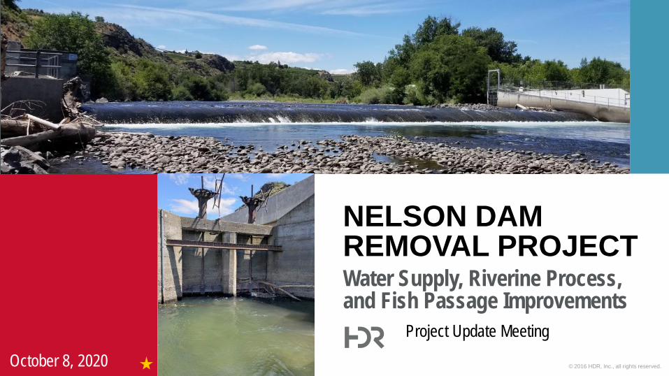
Water Supply, Riverine Process, and Fish Passage Improvements
NELSON DAM REMOVAL PROJECT
Project Update Meeting
October 8, 2020
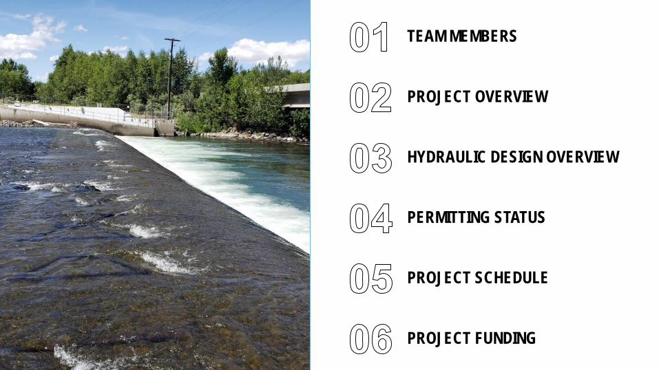
TEAM MEMBERS
PROJECT OVERVIEW
HYDRAULIC DESIGN OVERVIEW
PERMITTING STATUS
PROJECT SCHEDULE
PROJECT FUNDING

01 TEAM MEMBERS
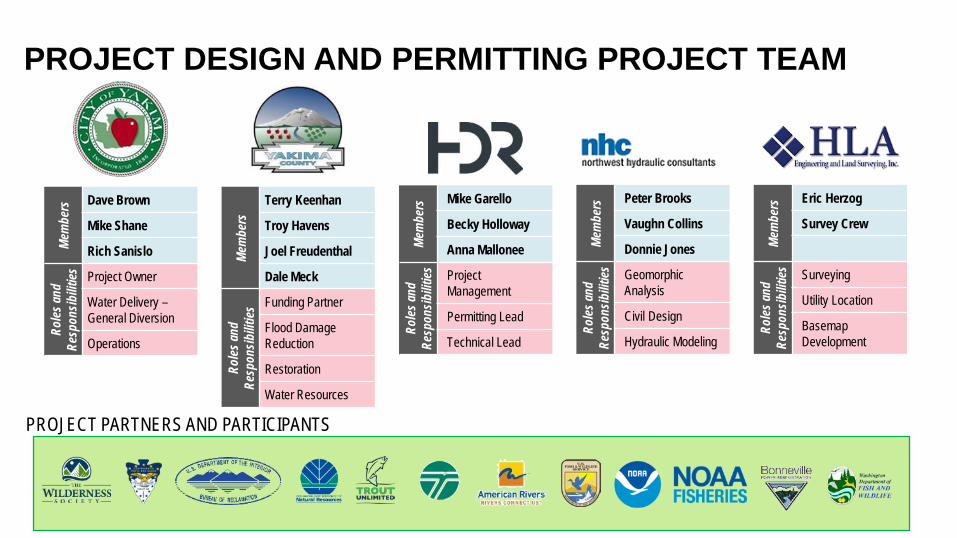
PROJECT DESIGN AND PERMITTING PROJECT TEAMMe
mbe
rs Dave Brown
Mike Shane
Rich Sanislo
Roles
and
Resp
onsib
ilities Project Owner
Water Delivery –General Diversion
Operations
Mem
bers
Terry Keenhan
Troy Havens
Joel Freudenthal
Dale Meck
Roles
and
Resp
onsib
ilities
Funding Partner
Flood DamageReduction
Restoration
Water Resources
Mem
bers Mike Garello
Becky Holloway
Anna Mallonee
Roles
and
Resp
onsib
ilities Project
Management
Permitting Lead
Technical Lead
Mem
bers Peter Brooks
Vaughn Collins
Donnie Jones
Roles
and
Resp
onsib
ilities Geomorphic
Analysis
Civil Design
Hydraulic Modeling
Mem
bers Eric Herzog
Survey Crew
Roles
and
Resp
onsib
ilities Surveying
Utility Location
Basemap Development
PROJECT PARTNERS AND PARTICIPANTS

02 PROJECT OVERVIEW
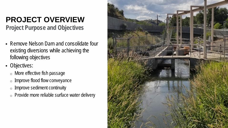
PROJECT OVERVIEWProject Purpose and Objectives
Remove Nelson Dam and consolidate four existing diversions while achieving the following objectives
Objectives:o More effective fish passageo Improve flood flow conveyanceo Improve sediment continuityo Provide more reliable surface water delivery
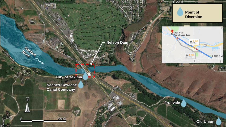
N
0 200 ft
Naches-Cowiche Canal Company
City of Yakima
Fruitvale
Old Union
Nelson Dam
Point of Diversion
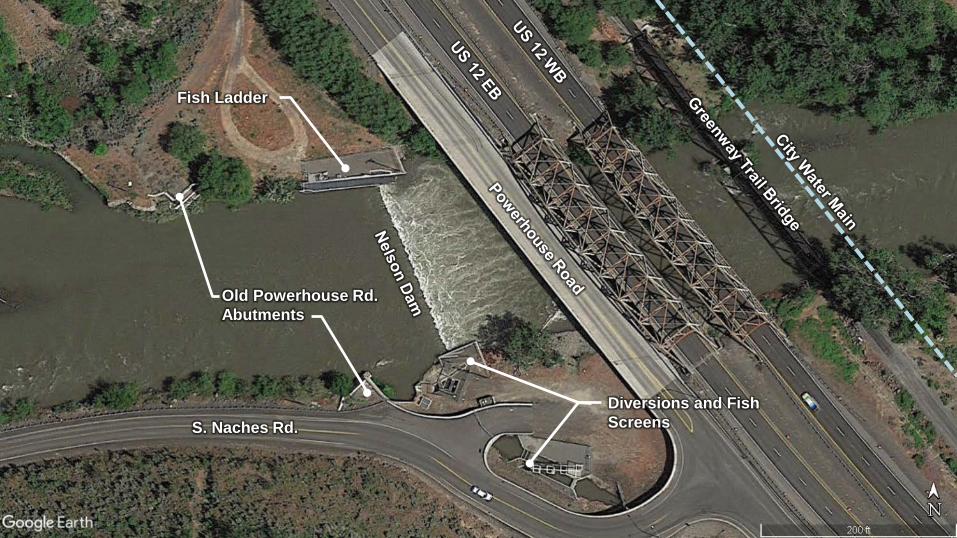
Fish Ladder
Old Powerhouse Rd.Abutments
S. Naches Rd.Diversions and Fish Screens
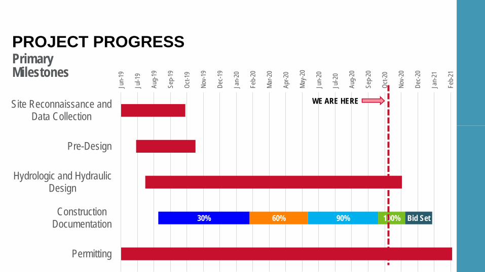
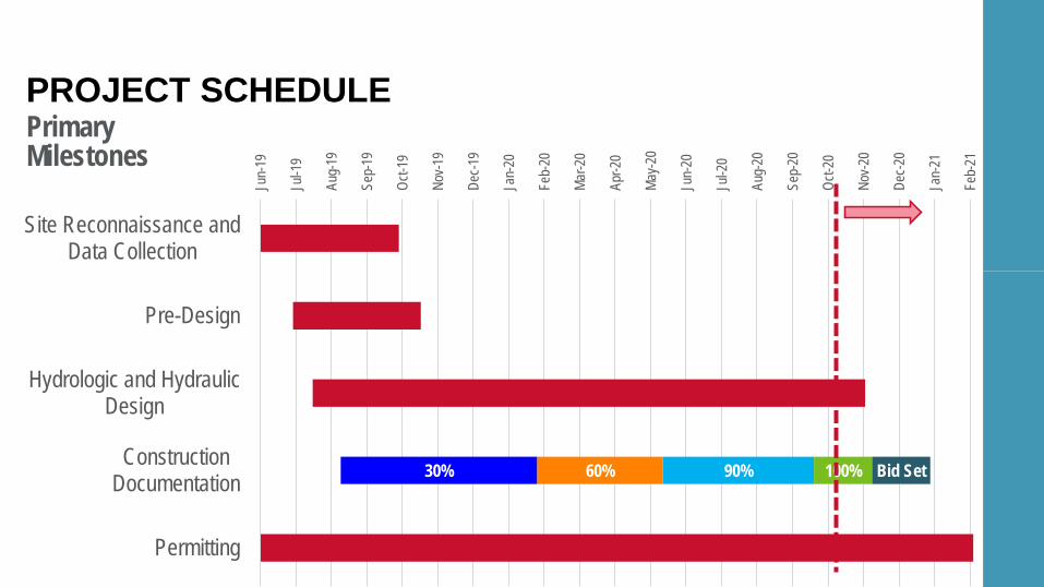
30% 60% 90% 100% Bid Set
Jun-
19
Jul-1
9
Aug-
19
Sep-
19
Oct-1
9
Nov-1
9
Dec-1
9
Jan-
20
Feb-
20
Mar-2
0
Apr-2
0
May-2
0
Jun-
20
Jul-2
0
Aug-
20
Sep-
20
Oct-2
0
Nov-2
0
Dec-2
0
Jan-
21
Feb-
21
Site Reconnaissance andData Collection
Pre-Design
Hydrologic and HydraulicDesign
ConstructionDocumentation
Permitting
PrimaryMilestones
PROJECT PROGRESS
WE ARE HERE
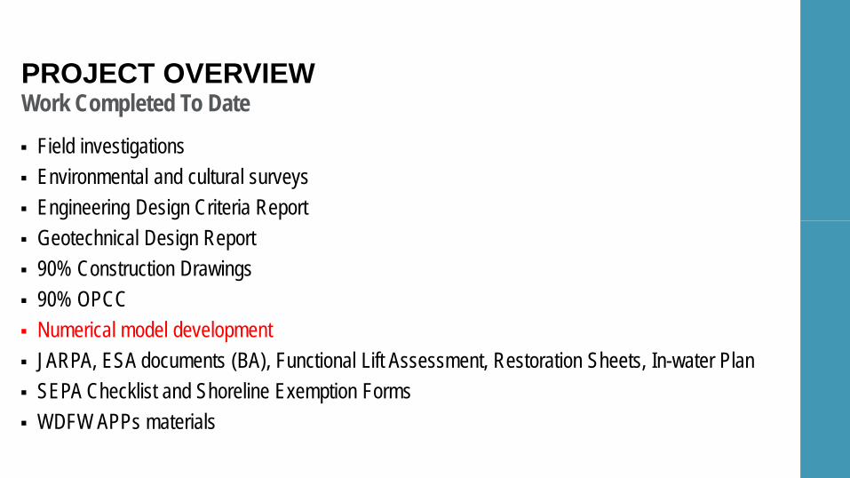
Work Completed To Date
Field investigations Environmental and cultural surveys Engineering Design Criteria Report Geotechnical Design Report 90% Construction Drawings 90% OPCC Numerical model development JARPA, ESA documents (BA), Functional Lift Assessment, Restoration Sheets, In-water Plan SEPA Checklist and Shoreline Exemption Forms WDFW APPs materials
PROJECT OVERVIEW
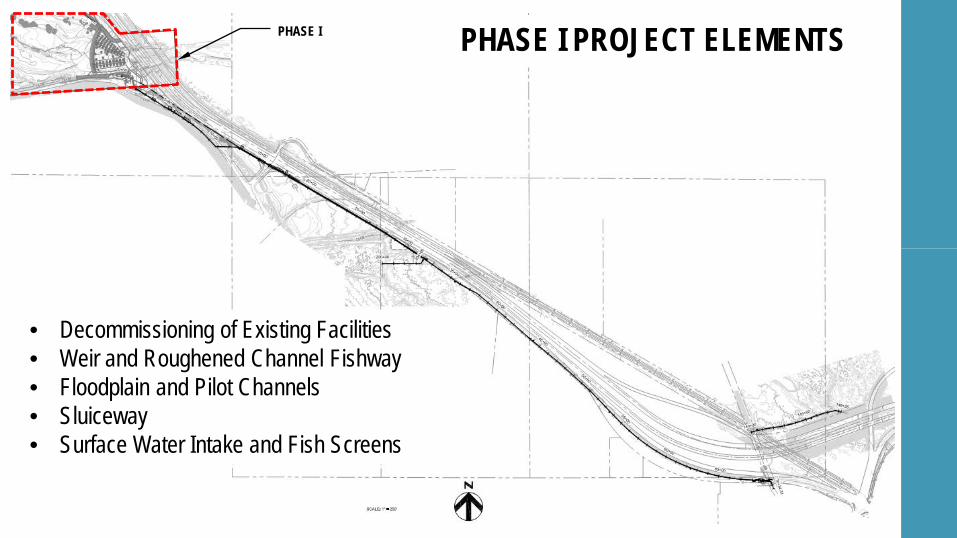
PHASE I PHASE I PROJECT ELEMENTS
• Decommissioning of Existing Facilities• Weir and Roughened Channel Fishway• Floodplain and Pilot Channels• Sluiceway• Surface Water Intake and Fish Screens
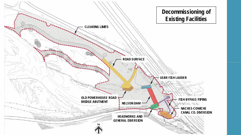
ROAD SURFACE
OLD POWERHOUSE ROAD BRIDGE ABUTMENT FISH BYPASS PIPING
USBR FISH LADDER
NELSON DAM
HEADWORKS AND GENERAL DIVERSION
NACHES-COWICHE CANAL CO. DIVERSION
Decommissioning of Existing Facilities
CLEARING LIMITS
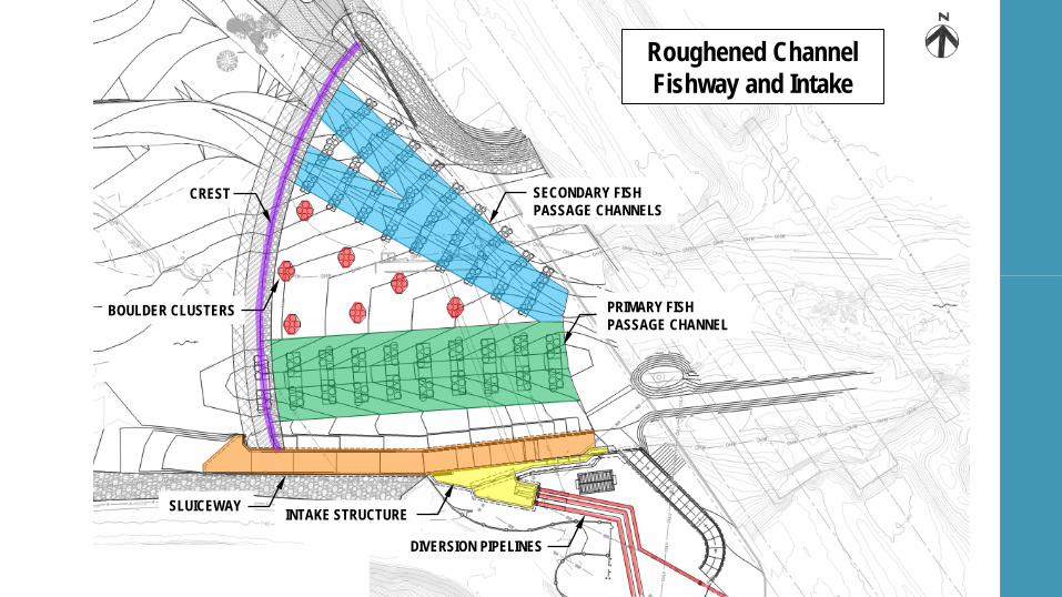
Roughened Channel Fishway and Intake
SECONDARY FISH PASSAGE CHANNELS
CREST
PRIMARY FISH PASSAGE CHANNEL
BOULDER CLUSTERS
SLUICEWAY INTAKE STRUCTURE
DIVERSION PIPELINES
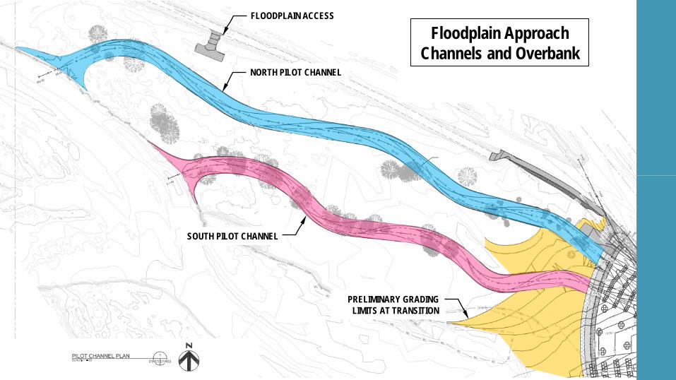
NORTH PILOT CHANNEL
PRELIMINARY GRADING LIMITS AT TRANSITION
SOUTH PILOT CHANNEL
Floodplain Approach Channels and Overbank
FLOODPLAIN ACCESS
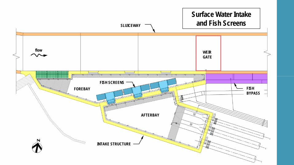
FISH SCREENS
INTAKE STRUCTURE
SLUICEWAY
WEIR GATE
AFTERBAY
FOREBAY
Surface Water Intake and Fish Screens
FISH BYPASS
flow
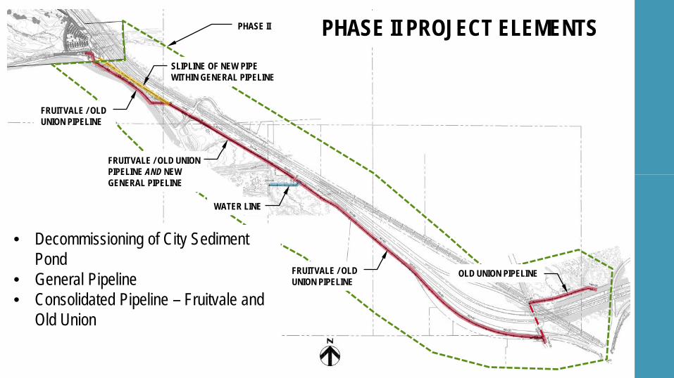
• Decommissioning of City Sediment Pond
• General Pipeline• Consolidated Pipeline – Fruitvale and
Old Union
SLIPLINE OF NEW PIPE WITHIN GENERAL PIPELINE
FRUITVALE / OLD UNION PIPELINE
FRUITVALE / OLD UNION PIPELINE AND NEW GENERAL PIPELINE
WATER LINE
FRUITVALE / OLD UNION PIPELINE
OLD UNION PIPELINE
PHASE II PHASE II PROJECT ELEMENTS
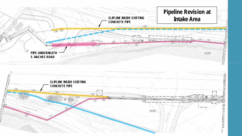
SLIPLINE INSIDE EXISTING CONCRETE PIPE
PIPE UNDERNEATH S. NACHES ROAD
Pipeline Revision at Intake Area
SLIPLINE INSIDE EXISTING CONCRETE PIPE
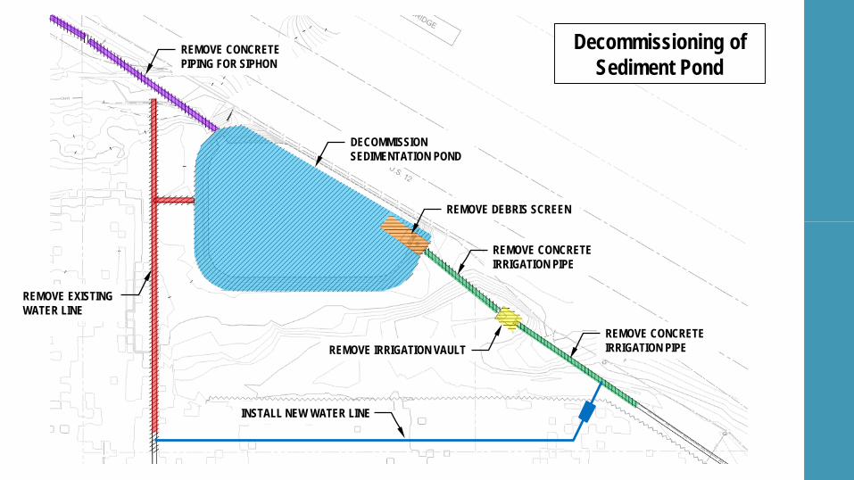
DECOMMISSION SEDIMENTATION POND
REMOVE IRRIGATION VAULT
REMOVE DEBRIS SCREEN
REMOVE CONCRETE PIPING FOR SIPHON
REMOVE EXISTING WATER LINE
REMOVE CONCRETE IRRIGATION PIPE
REMOVE CONCRETE IRRIGATION PIPE
Decommissioning of Sediment Pond
INSTALL NEW WATER LINE
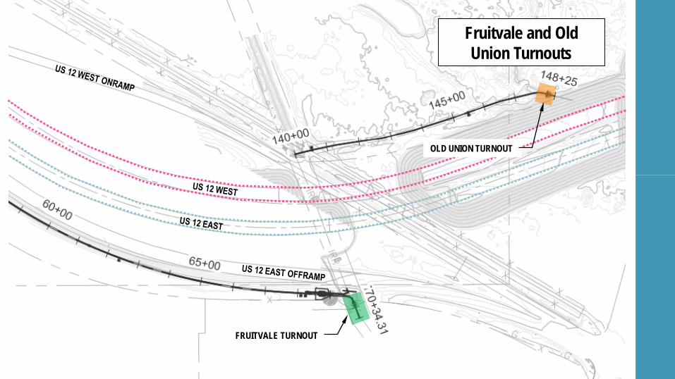
Fruitvale and Old Union Turnouts
FRUITVALE TURNOUT
OLD UNION TURNOUT
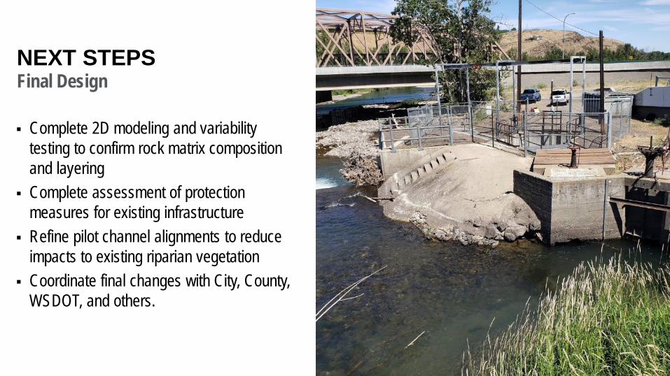
NEXT STEPSFinal Design
Complete 2D modeling and variability testing to confirm rock matrix composition and layering
Complete assessment of protection measures for existing infrastructure
Refine pilot channel alignments to reduce impacts to existing riparian vegetation
Coordinate final changes with City, County, WSDOT, and others.

03 HYDRAULIC DESIGN OVERVIEW
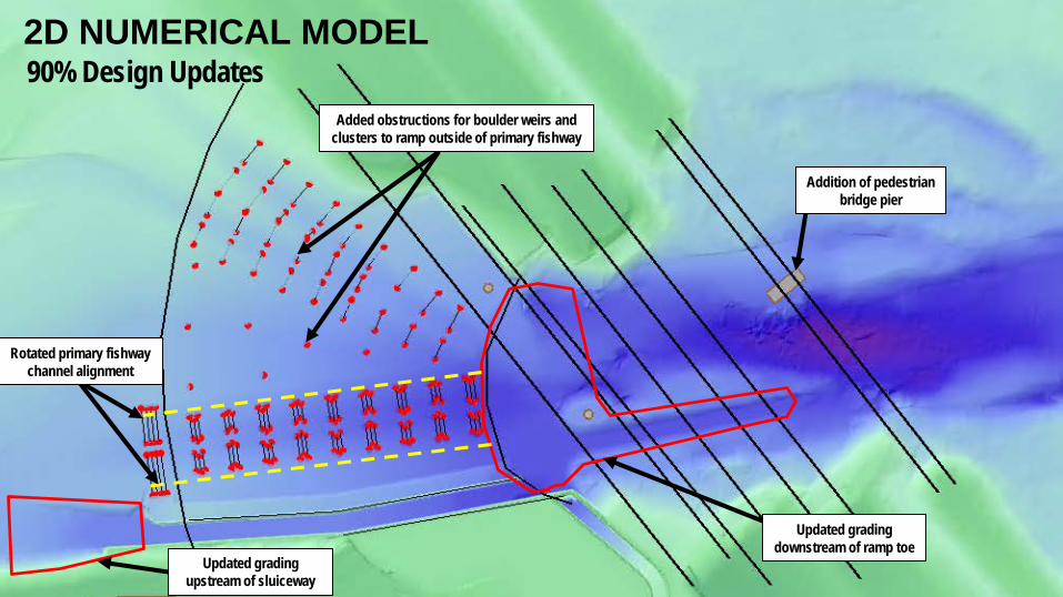
90% Design Updates2D NUMERICAL MODEL
Addition of pedestrian bridge pier
Updated grading downstream of ramp toe
Rotated primary fishway channel alignment
Added obstructions for boulder weirs and clusters to ramp outside of primary fishway
Updated grading upstream of sluiceway
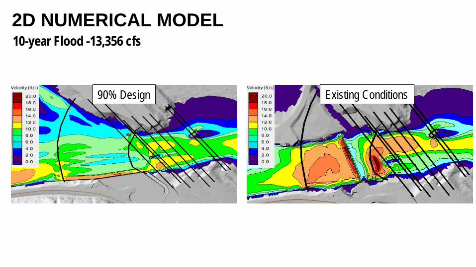
10-year Flood -13,356 cfs2D NUMERICAL MODEL
Existing Conditions90% Design
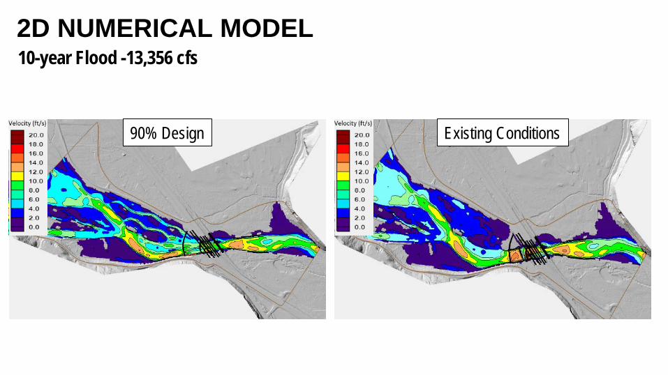
10-year Flood -13,356 cfs2D NUMERICAL MODEL
Existing Conditions90% Design
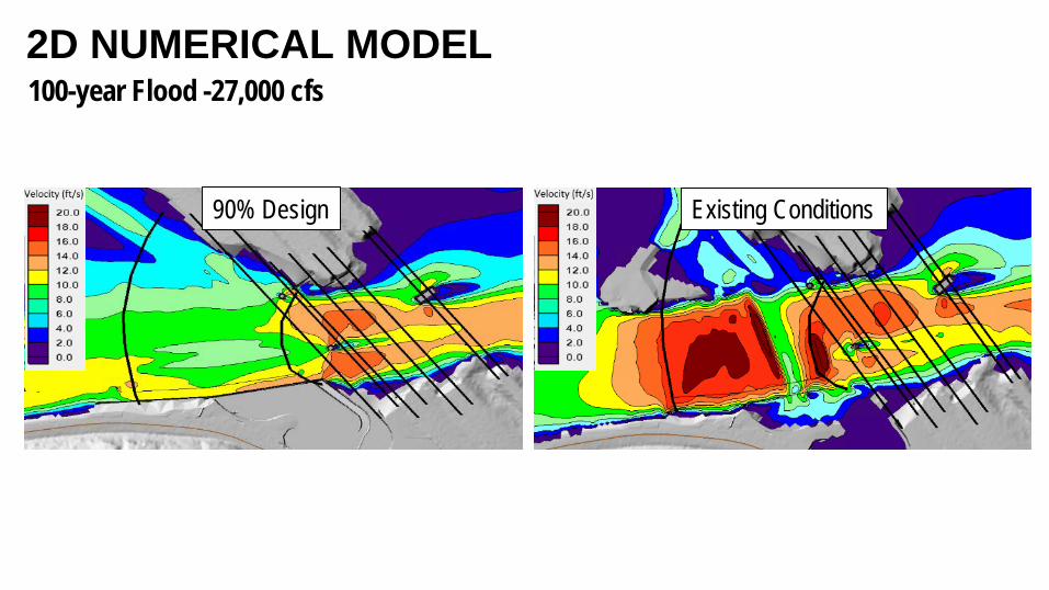
100-year Flood -27,000 cfs2D NUMERICAL MODEL
Existing Conditions90% Design
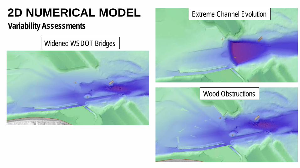
Variability Assessments2D NUMERICAL MODEL Extreme Channel Evolution
Wood Obstructions
Widened WSDOT Bridges
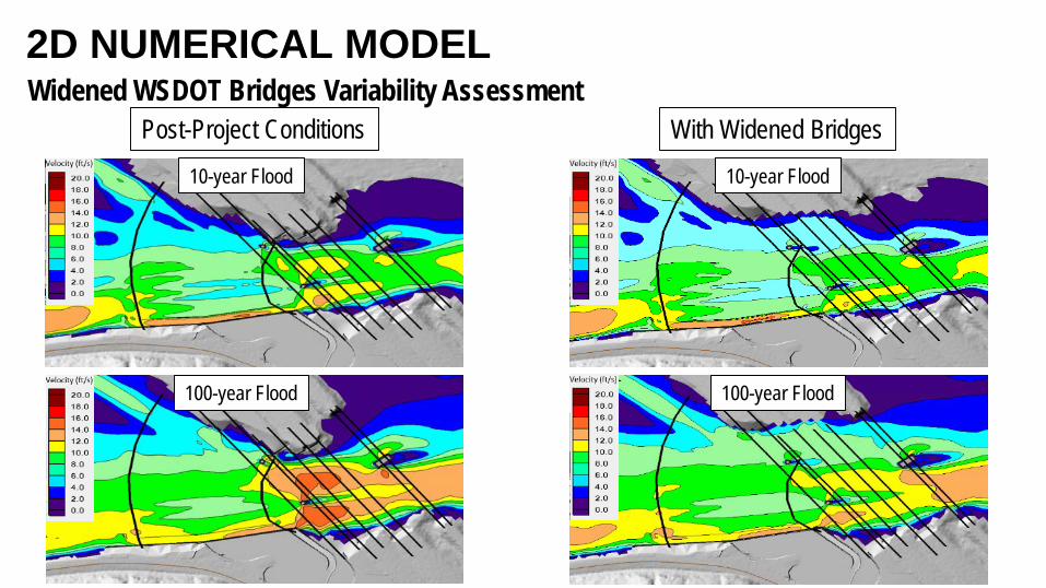
Widened WSDOT Bridges Variability Assessment2D NUMERICAL MODEL
With Widened BridgesPost-Project Conditions10-year Flood
100-year Flood
10-year Flood
100-year Flood
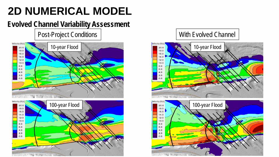
Evolved Channel Variability Assessment2D NUMERICAL MODEL
With Evolved ChannelPost-Project Conditions10-year Flood
100-year Flood
10-year Flood
100-year Flood
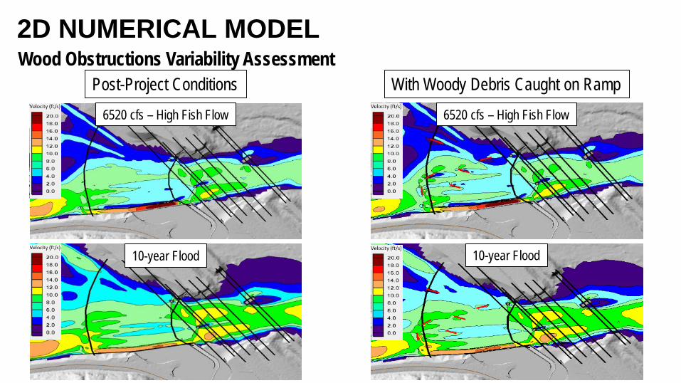
Wood Obstructions Variability Assessment2D NUMERICAL MODEL
With Woody Debris Caught on RampPost-Project Conditions6520 cfs – High Fish Flow
10-year Flood 10-year Flood
6520 cfs – High Fish Flow
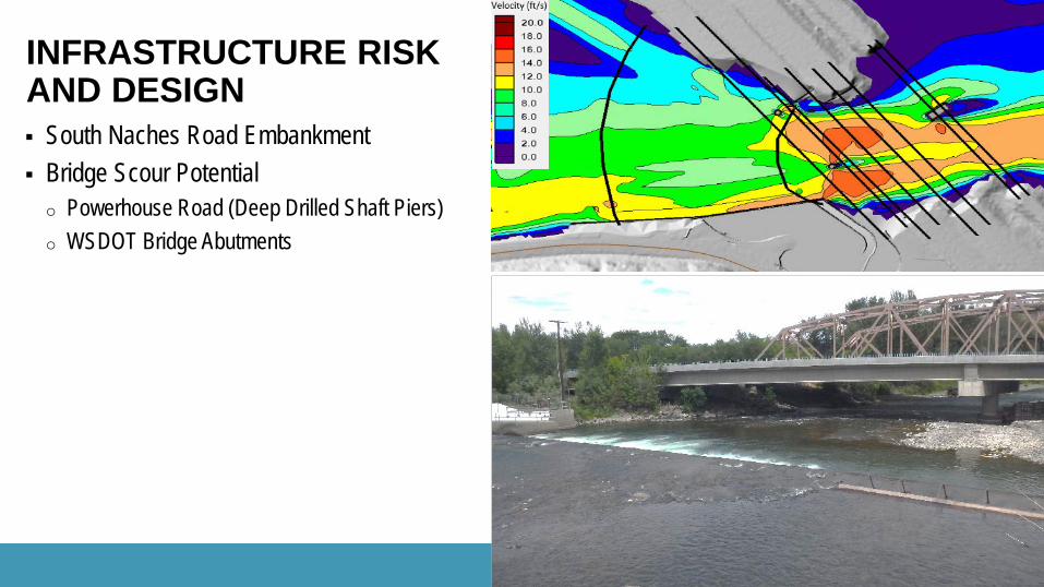
South Naches Road Embankment Bridge Scour Potentialo Powerhouse Road (Deep Drilled Shaft Piers)o WSDOT Bridge Abutments
INFRASTRUCTURE RISK AND DESIGN
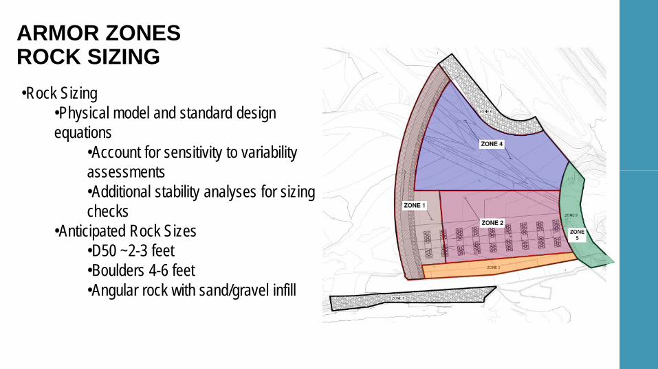
ARMOR ZONESROCK SIZING•Rock Sizing
•Physical model and standard design equations
•Account for sensitivity to variability assessments•Additional stability analyses for sizing checks
•Anticipated Rock Sizes•D50 ~2-3 feet•Boulders 4-6 feet•Angular rock with sand/gravel infill
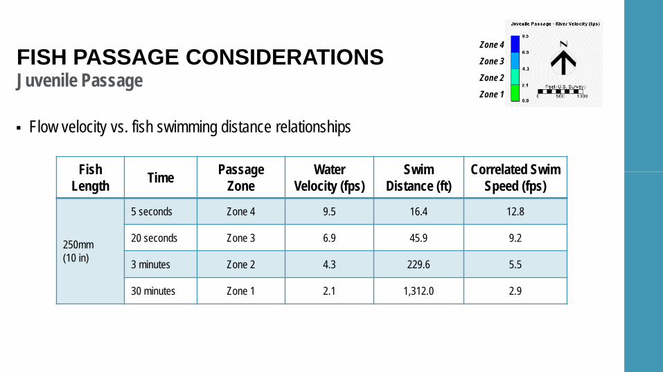
Juvenile Passage
Flow velocity vs. fish swimming distance relationships
FISH PASSAGE CONSIDERATIONS
Fish Length Time Passage
ZoneWater
Velocity (fps)Swim
Distance (ft)Correlated Swim
Speed (fps)
250mm(10 in)
5 seconds Zone 4 9.5 16.4 12.8
20 seconds Zone 3 6.9 45.9 9.2
3 minutes Zone 2 4.3 229.6 5.5
30 minutes Zone 1 2.1 1,312.0 2.9
Zone 4
Zone 3
Zone 2
Zone 1
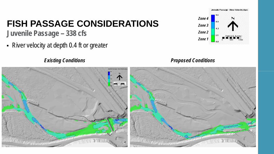
Juvenile Passage – 338 cfsFISH PASSAGE CONSIDERATIONS
Existing Conditions Proposed Conditions
Zone 4
Zone 3
Zone 2
Zone 1
River velocity at depth 0.4 ft or greater
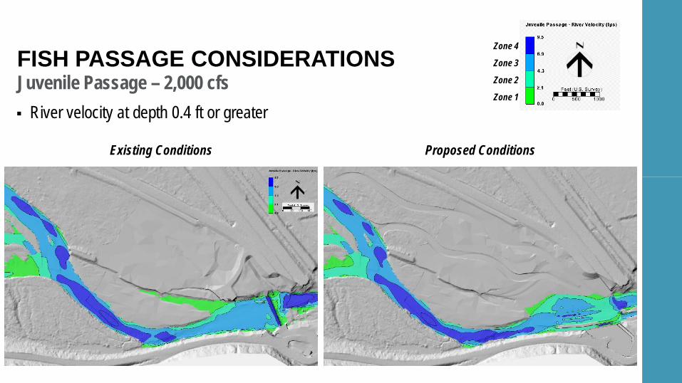
Juvenile Passage – 2,000 cfsFISH PASSAGE CONSIDERATIONS
Existing Conditions Proposed Conditions
Zone 4
Zone 3
Zone 2
Zone 1
River velocity at depth 0.4 ft or greater
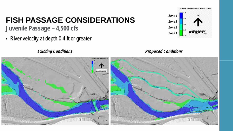
Juvenile Passage – 4,500 cfsFISH PASSAGE CONSIDERATIONS
Existing Conditions Proposed Conditions
Zone 4
Zone 3
Zone 2
Zone 1
River velocity at depth 0.4 ft or greater
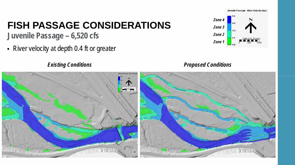
Juvenile Passage – 6,520 cfsFISH PASSAGE CONSIDERATIONS
Existing Conditions Proposed Conditions
Zone 4
Zone 3
Zone 2
Zone 1
River velocity at depth 0.4 ft or greater
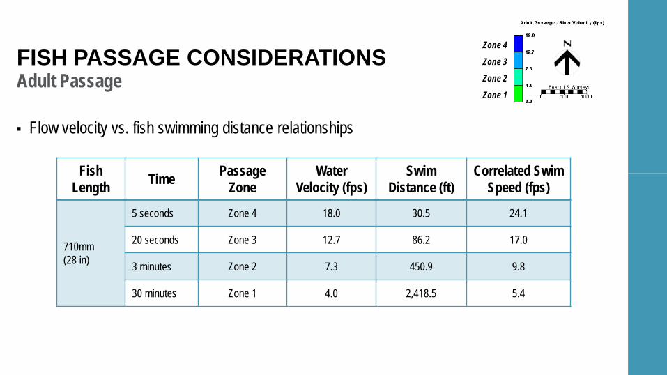
Adult Passage
Flow velocity vs. fish swimming distance relationships
FISH PASSAGE CONSIDERATIONS
Fish Length Time Passage
ZoneWater
Velocity (fps)Swim
Distance (ft)Correlated Swim
Speed (fps)
710mm(28 in)
5 seconds Zone 4 18.0 30.5 24.1
20 seconds Zone 3 12.7 86.2 17.0
3 minutes Zone 2 7.3 450.9 9.8
30 minutes Zone 1 4.0 2,418.5 5.4
Zone 4
Zone 3
Zone 2
Zone 1
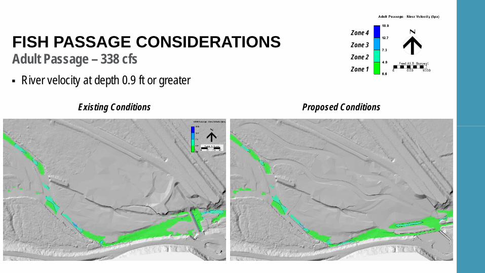
Adult Passage – 338 cfsFISH PASSAGE CONSIDERATIONS
Existing Conditions Proposed Conditions
Zone 4
Zone 3
Zone 2
Zone 1
River velocity at depth 0.9 ft or greater
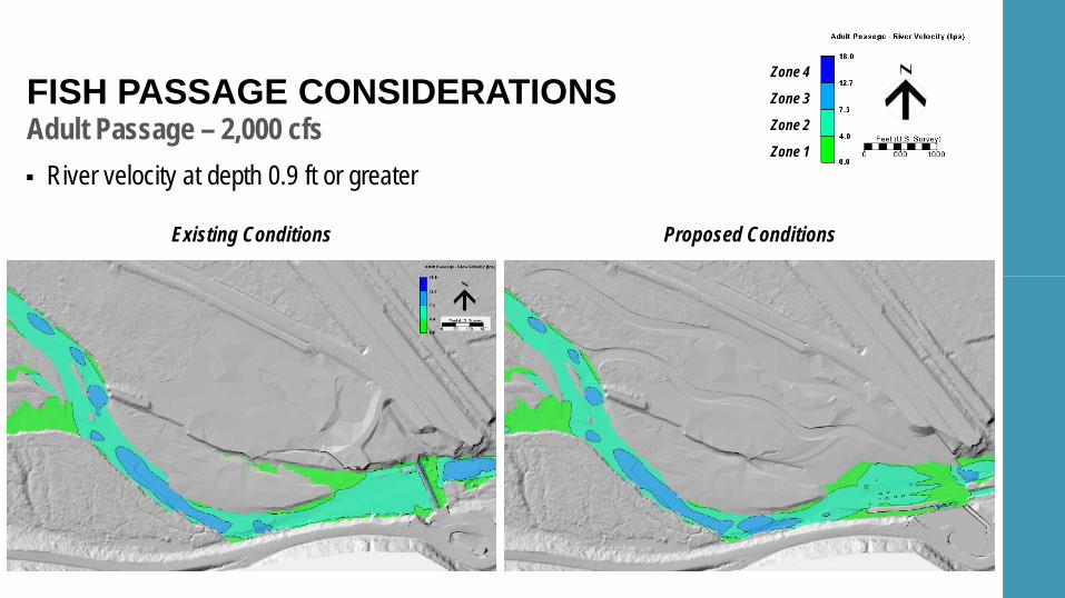
Adult Passage – 2,000 cfsFISH PASSAGE CONSIDERATIONS
Existing Conditions Proposed Conditions
Zone 4
Zone 3
Zone 2
Zone 1
River velocity at depth 0.9 ft or greater
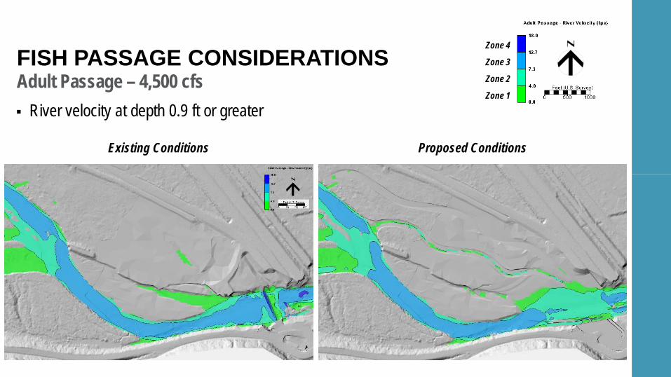
Adult Passage – 4,500 cfsFISH PASSAGE CONSIDERATIONS
Existing Conditions Proposed Conditions
Zone 4
Zone 3
Zone 2
Zone 1
River velocity at depth 0.9 ft or greater
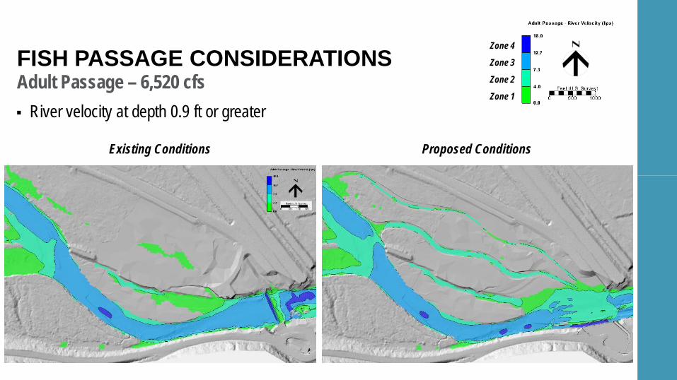
Adult Passage – 6,520 cfsFISH PASSAGE CONSIDERATIONS
Existing Conditions Proposed Conditions
Zone 4
Zone 3
Zone 2
Zone 1
River velocity at depth 0.9 ft or greater

04 PERMITTING STATUS
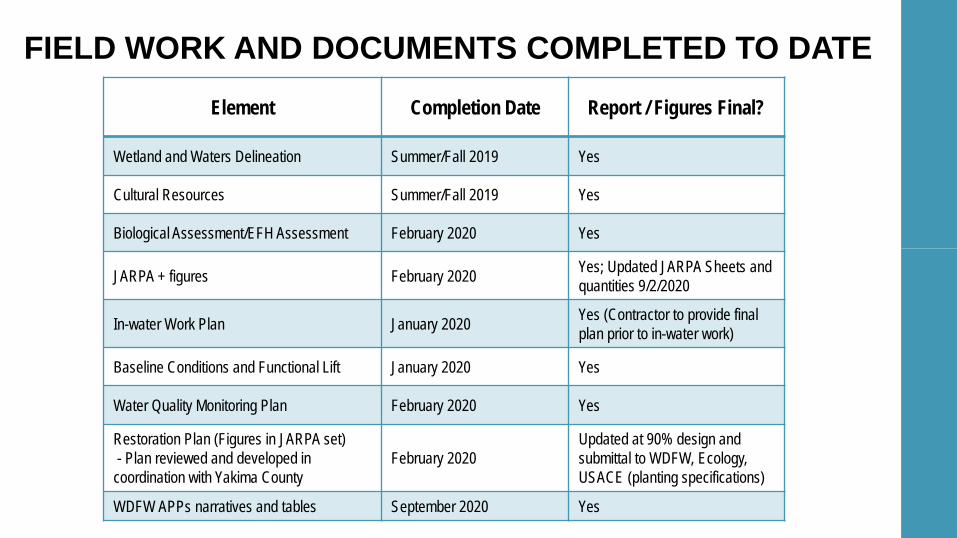
FIELD WORK AND DOCUMENTS COMPLETED TO DATEElement Completion Date Report / Figures Final?
Wetland and Waters Delineation Summer/Fall 2019 Yes
Cultural Resources Summer/Fall 2019 Yes
Biological Assessment/EFH Assessment February 2020 Yes
JARPA + figures February 2020 Yes; Updated JARPA Sheets and quantities 9/2/2020
In-water Work Plan January 2020 Yes (Contractor to provide final plan prior to in-water work)
Baseline Conditions and Functional Lift January 2020 Yes
Water Quality Monitoring Plan February 2020 Yes
Restoration Plan (Figures in JARPA set)- Plan reviewed and developed in
coordination with Yakima CountyFebruary 2020
Updated at 90% design and submittal to WDFW, Ecology, USACE (planting specifications)
WDFW APPs narratives and tables September 2020 Yes
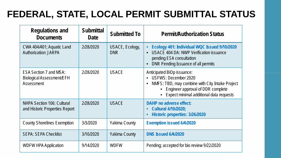
FEDERAL, STATE, LOCAL PERMIT SUBMITTAL STATUSRegulations and
DocumentsSubmittal
Date Submitted To Permit/Authorization Status
CWA 404/401; Aquatic Land Authorization: JARPA
2/28/2020 USACE, Ecology, DNR
• Ecology 401: Individual WQC Issued 9/10/2020• USACE 404 DA: NWP Verification issuance
pending ESA consultation • DNR Pending Issuance of all permits
ESA Section 7 and MSA: Biological Assessment/EFH Assessment
2/28/2020 USACE Anticipated BiOp issuance: • USFWS: December 2020• NMFS: TBD, may combine with City Intake Project
• Engineer approval of DDR complete• Expect minimal additional data requests
NHPA Section 106: Cultural and Historic Properties Report
2/28/2020 USACE DAHP no adverse effect: • Cultural 4/10/2020; • Historic properties: 3/26/2020
County Shorelines Exemption 3/3/2020 Yakima County Exemption issued 6/4/2020
SEPA: SEPA Checklist 3/10/2020 Yakima County DNS Issued 6/4/2020
WDFW HPA Application 9/14/2020 WDFW Pending; accepted for bio review 9/22/2020
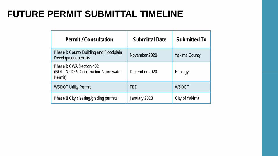
FUTURE PERMIT SUBMITTAL TIMELINE
Permit / Consultation Submittal Date Submitted To
Phase I: County Building and FloodplainDevelopment permits November 2020 Yakima County
Phase I: CWA Section 402 (NOI - NPDES Construction Stormwater Permit)
December 2020 Ecology
WSDOT Utility Permit TBD WSDOT
Phase II City clearing/grading permits January 2023 City of Yakima
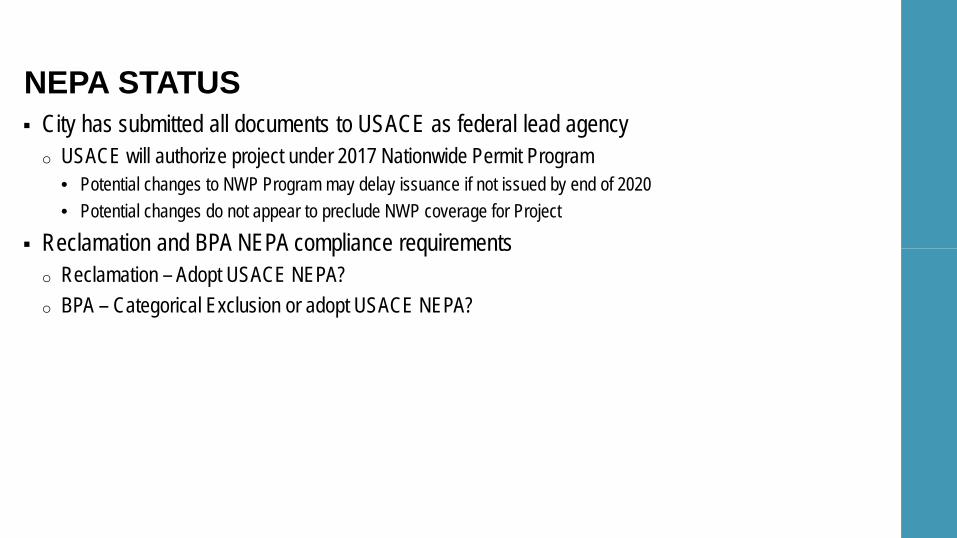
City has submitted all documents to USACE as federal lead agencyo USACE will authorize project under 2017 Nationwide Permit Program
• Potential changes to NWP Program may delay issuance if not issued by end of 2020• Potential changes do not appear to preclude NWP coverage for Project
Reclamation and BPA NEPA compliance requirementso Reclamation – Adopt USACE NEPA?o BPA – Categorical Exclusion or adopt USACE NEPA?
NEPA STATUS

05 PROJECT SCHEDULE
30% 60% 90% 100% Bid Set
Jun-
19
Jul-1
9
Aug-
19
Sep-
19
Oct-1
9
Nov-1
9
Dec-1
9
Jan-
20
Feb-
20
Mar-2
0
Apr-2
0
May-2
0
Jun-
20
Jul-2
0
Aug-
20
Sep-
20
Oct-2
0
Nov-2
0
Dec-2
0
Jan-
21
Feb-
21
Site Reconnaissance andData Collection
Pre-Design
Hydrologic and HydraulicDesign
ConstructionDocumentation
Permitting
PrimaryMilestones
PROJECT SCHEDULE
Jun-
19
Dec-1
9
Jun-
20
Dec-2
0
Jun-
21
Dec-2
1
Jun-
22
Dec-2
2
Jun-
23
Dec-2
3
Jun-
24
Jan-
25
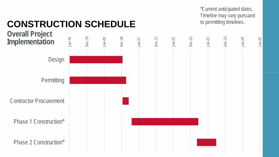
Design
Permitting
Contractor Procurement
Phase 1 Construction*
Phase 2 Construction*
Overall ProjectImplementation
CONSTRUCTION SCHEDULE*Current anticipated dates. Timeline may vary pursuant to permitting timelines.

06 PROJECT FUNDING
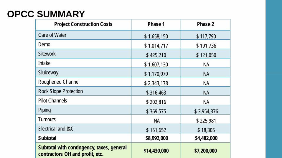
OPCC SUMMARYProject Construction Costs Phase 1 Phase 2
Care of Water $ 1,658,150 $ 117,790 Demo $ 1,014,717 $ 191,736 Sitework $ 425,210 $ 121,050 Intake $ 1,607,130 NA Sluiceway $ 1,170,979 NA Roughened Channel $ 2,343,178 NA Rock Slope Protection $ 316,463 NA Pilot Channels $ 202,816 NA Piping $ 369,575 $ 3,954,376 Turnouts NA $ 225,981 Electrical and I&C $ 151,652 $ 18,305 Subtotal $8,992,000 $4,482,000 Subtotal with contingency, taxes, general contractors OH and profit, etc. $14,430,000 $7,200,000
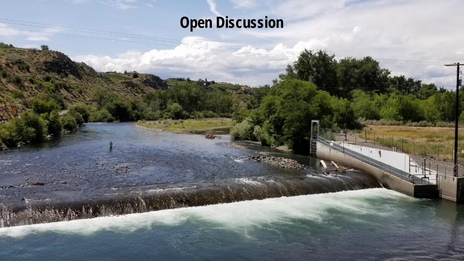
Open Discussion


![Yakima herald (Yakima, Wash.) 1911-03-22 [p 4]chroniclingamerica.loc.gov/lccn/sn88085523/1911-03-22/ed-1/seq-4.… · dam Is all part of the great work, and the road Itself, traversing](https://img.pdfslide.us/doc/110x75/5f535b8c4f87235f892bf8d6/yakima-herald-yakima-wash-1911-03-22-p-4-dam-is-all-part-of-the-great-work.jpg)

![VSP steelhead telemetry PAR 2012 data (2 of 2) [Read-Only] Review... · 2013-03-13 · Upper Yak Steelhead: Arrival below Roza Dam Yakima Mainstem & Wenas Cr Roza Dam Yakima Mainstem](https://img.pdfslide.us/doc/110x75/5e5d9870aeed9a3aa361aebb/vsp-steelhead-telemetry-par-2012-data-2-of-2-read-only-review-2013-03-13.jpg)