Embed Size (px)
Citation preview

Page | 1
Need assessment and detailed planning for a harmonious hydrometeorology system for the Sundarbans
Part – II
LOOKING AT COMPARABLE DELTAS :
EXPERIENCES FROM MEKONG
Prelude
Detail discussion on Hydro-meteorological set up in Sundarbans spreading over two countries, namely Bangladesh and India points to the fact that ‘All is Not Well’ with it. There
is lack of infrastructure, lack in common understanding, deficiency in technical knowledge,
confusion regarding institution, shortage in implementation, lack in trust between two countries and most important lack in sharing of knowledge regarding a delta with same and
identical physiographic set up supporting life and livelihood of about 10 million people,
although in a miserable state of affair, at the same time internationally accepted as a
biodiversity hotspot. Things would have been easier with a common pool of knowledge being
shared between authorities of Sundarbans in two countries under the umbrella of any
institutionalised form with timely and precise intervention for protection of life and livelihood
of these 10 million populations and for conservation of this fragile ecosystem.
Experiences from other deltas where the river is a common thread between adjacent countries producing natural resources and supporting a sizeable number of populations
spreading over different countries may help in framing appropriate strategy for building up a
common pool of infrastructure and knowledge based on mutual trust and shared benefits between these two neighbouring countries, which are always friendly to each other. The
experiences from Mekong River may be counted as the best one since in this case four
countries, which are having divergent political set up and even known hostility on several
counts, have come together in an institutionalised manner and with several commonly
accepted guiding principles for the conservation of natural resources and common gene pool
Pub
lic D
iscl
osur
e A
utho
rized
Pub
lic D
iscl
osur
e A
utho
rized
Pub
lic D
iscl
osur
e A
utho
rized
Pub
lic D
iscl
osur
e A
utho
rized

Page | 2
which is crucial for life and livelihood of 65 million people living in Lower Mekong Basin (MRC,
2018) in four different countries namely Thailand, Cambodia, Lao PDR and Vietnam, since a
sizeable portion of these countries are situated on the same river basin and sharing the water
resources of the same river “The Mekong”.
Introduction
The Mekong River System originates from the Tibetan Plateau (Tuan, L. A. & et al, 2007) and
travels some 4,909 km through six countries namely Chaina, Maynamar, Laos PDR, Thailand,
Cambodia and Vietnam and finally discharges into the South China Sea. The Yangtze, Salween,
Irrawaddy, Red and Mekong rivers all begin their long journeys on the Tibetan Plateau at
4,500 or more metres above sea level. Here, this family of great rivers are separated by only
a few hundred kilometres before moving off in different directions (MRC, 2005). The Yangtze
flows across all of central China, the Red River runs through Viet Nam to the Gulf of Tonkin, and the Salween and Irrawaddy through Myanmar into the Indian Ocean. The Greater
Mekong can be divided into two parts: the Upper Basin in Tibet and China (where the river is
called the Lancang Jiang), and the Lower Mekong Basin from Yunnan downstream from China to the South China Sea. The Upper Basin makes up 24 per cent of the total area and
contributes 15 to 20 per cent of the water that flows into the Mekong River. The catchment
here is steep and narrow. Soil erosion has been a major problem and approximately 50 per
cent of the sediment in the river comes from the Upper Basin.
From its source, the Mekong continues south for approximately 4,909 km to drain a total land
area of 7,95,000 km2 which has been designated as Mekong Basin of which 606,000 km2 is in
the Lower Mekong Basin and comprises almost entire Laos PDR and Cambodia, one third of
Thailand (its North-eastern region and part of its Northern region), and one fifth of Vietnam
(the Central Highlands and the Delta) (Plate & Insisiengmay, 2002). Interestingly, Mekong
Basin, in spite of considerable development and population pressure, has retained the original
landscape and the flood inundation to a large extent as a result of which it has protected its
rich biological diversity and thereby marked as the 2nd most biologically diverse river in the
world (WWF, 2004). The Mekong ranks 10th amongst the world’s great rivers on the basis of
mean annual flow at the mouth.

Page | 3
The Mekong River flows
are collected from many
sources and it has been
estimated that annual
discharge of Mekong River
System is about 470 km3
(Lu and Siew, 2005).
Mekong River is extremely
important for the
economies of these six
countries especially
Thailand, Laos PDR,
Cambodia and Vietnam. It
is very much present in the
social, economic and cultural life of the four
countries of the Lower
Mekong Basin (LMB), and shapes the economic
prospects of these
countries and their mutual
relations.
Figure – 1 : Broad Regions of Mekong River Basin (MRC, 2005)
Life and Livelihood of more than 65 million populations spreading over several countries is
dependent on the Mekong River and Mekong Basin. The major issues in the basin concern the
reasonable and equitable sharing of water resources, and the sustainable development of
natural resources (MRC & JICA Report, 2004). The Mekong is the common physical thread
that defines the geographical region that is widely referred to as Indochina, drawing together
Cambodia, Laos, Thailand and Vietnam into a single international water resources economy.
These four countries have long recognised the need for joint cooperation and mutual
consideration when planning and designing new water utilisation projects within a single
trans-boundary river basin, this spirit of collaboration being embodied in the Mekong
Agreement of 1995. Similarly, it has a major impact on the south-western part of PR China,
especially Yunnan province. It counts among the 10 largest rivers in the world, but stands
apart because of the extreme fluctuations in seasonal discharge: very low flows in the dry

Page | 4
season, yet extensive flooding in the wet season which nurtures the basin’s huge wetlands
such as the world famous Tonle Sap in Cambodia (Anonymous, 2006).
Figure – 2 : Topography and Relief of Lower Mekong Basin (MRC, 2005)
According to Mekong News (2003), farmers in the whole Mekong Basin produce enough rice
to feed an estimated 300 million people a year. They are producing about half of Vietnam’s

Page | 5
total rice output (Thi Thuy and Furukawa, 2007). Average Sediment discharge by Mekong
River is about 160 million tons per year (Milliman & Ren, 1995) (although there is enough
variability in figures from different authors), which has similarity with the Ganga–
Brahmaputra River system wherein the sediment load has been estimated ranging from 402
to 710 × 106 tonnes/year for the Brahmaputra River and from 403 to 660 × 106 tonnes/year
for the Ganges River separately and cumulatively 80 to 137 million tons per year
(Subramanian & Ramanathan, 1996). Another estimation puts this figure to be around 100
million tons per year (Steven & Steven 1999). Thus, there is distinct similarity in physiographic
set up between Ganga Brahmaputra River system giving rise to Ganga Brahmaputra Delta
(GBP) on which Sundarban is located and the Mekong River System.
Figure – 3 : Mekong Basin with Political Boundaries of Different Countries (MRC, 2017)

Page | 6
The lower Mekong River, which flows through the Mekong River Delta which is home for 18
million Vietnamese (Tuan et al., 2007), is controlled by tides and seasonal variations of fluvial
discharge. The decreased freshwater flow in the lower Mekong channel modifies flow and
sediment dynamics, and intensifies saltwater intrusion in the low-flow season (Gagliano and
McIntire, 1968). Combining with the subsidence and sea-level rise, the Mekong Delta is
predicted to experience significant changes in its future evolution (Ericson et al., 2006; Carew-
Reid, 2008; McSweeney et al., 2010; Erban et al., 2014). Thus, there is a great deal of similarity
of Sundarbans with Mekong Delta since it also experiences subsidence.
The Mekong River bifurcates into the Song Hau and the Song Tien distributaries in the delta
plain. The two distributaries ultimately divide into eight channels which flow into East Sea.
The lower Song Hau distributary includes Dinh An and Tran De sub-distributary channels (Xien
et al, 2017). The Song Hau distributary carries about 41% of the total Mekong water discharge,
of which ~70% flows through the Dinh An channel and ~30% flows through the Tran De channel (Nguyen et al., 2008).
Current estimates of the annual sediment load for the Mekong River vary significantly from
40 to 160 Mt (Walling, 2008: 160 Mt/yr; Milliman and Farnsworth, 2011: 110 Mt/yr; Lu et al.,
2014: 50–91 Mt/yr; Nowacki et al., 2015: 40 Mt/yr). Milliman and Farnsworth (2011) estimated that the annual dissolved sediment load is approximately 60 Mt.
The Lower Mekong River Basin Accounts for 76% of the entire basin, as given below:
Table – 1 : Distribution of Catchment area of the Mekong River in six different countries
Sl. No.
Country Catchment Area (km2)
Remarks
1. China 165,000 (21%)
2. Mynamar 24,000 (3%)
3. Laos PDR 202,000 (25%) Lower Mekong River
Basin’s total
Catchment Area:
606,000 km2 (76% of
entire basin)
4. Thailand 184,000 (23%)
5. Cambodia 155,000 (20%)
6. Vietnam 65,000 (8%)
7. Total 795,000
Source : Joint Report of MRC & JICA, 2004

Page | 7
Mekong Delta
Figure – 4 : Map of Mekong Delta (Source: Nguyen and Savenije, 2006)
The Mekong Delta section of the LMB is in Vietnam, the last country through which the
Mekong River reaches out into the East Sea. The catchment area of the Mekong River Basin
in Vietnam is 65,000 km2 (Tuan, L. A. & et al, 2007). Similar to GBD, the river network of
Mekong also forms an intricate network of rivers and a dense canal network as it approaches
the sea.
The Mekong meets Tonle Sap River west of Phnom Penh. The Mekong then flows across the
border of Vietnam especially from the Tonle Sap River in Cambodia to the East Sea of Vietnam.
After entering Vietnam, the Mekong River splits into two branches, the Bassac (known as the

Page | 8
Hau River in Vietnam) and the Mekong (known as the Tien River in Vietnam). These two
branches actually form the Mekong Delta (Abedin et al, 2013). The Hau River is the
southernmost branch of the river system. The Hau River subsequently splits into two sub-
branches: Tran De and Dinh An. The Tien River is the northern branch of the Mekong River
system, which also separates at a place known as Vinh Long into two sub-branches namely,
Co Chien and My Tho. At a distance of 30 km from the South China Sea, the Co Chien River
again splits into two smaller branches, Co Chien and Cung Hau. In the downstream part, the
My Tho River separates into four branches: Tieu, Dai, Ba Lai, and Ham Luong. Six tributaries
of the Tien River and three tributaries of the Hau River together form what is called in the Vietnamese language the “Nine Dragons” (Cuu Long) (Tuan, L. A. & et al, 2007). The River
discharge at Tan Chau is 3-5 times larger than that of Chau Doc (Nguyen, 2006). The Vam Nao,
connecting river 20 km downstream of Tan Chau and Chau Doc, conveys water from the Tien
River to the Hau River, augmenting flow downstream of this point.
Most part of the Mekong Delta is situated within Vietnam itself and is distributed in 13
provinces, namely Long An, Tien Giang, Ben Tre, Dong Thap, Vinh Long, Tra Vinh, An Giang,
Can Tho, Hau Giang, Soc Trang, Bac Lieu, Ca Mau, and Kien Giang (Abedin et al, 2013). The Delta covers an area of 39,000 km2. Total population living in the Mekong Delta is about 18
million people. Delta’s rich resources are of vital importance to Vietnam, as they account for
some 40% of agricultural production in the country, including 50% of the rice production (Trinh & Nguyen, 2005). Rice and fishery products contribute significantly to export earnings
and account for about 27% of the gross domestic product (Abedin et al, 2013).
There is an extensive network of canals that has been constructed in the last 300 years. The
structures comprise 7,000 km of main canals, 4,000 km of secondary canals on-farm systems,
and more than 20,000 km of protection dykes to prevent early floods (MARD, 2003). Thus, such a situation is similar to Sundarbans wherein earthen embankments and polders have
been constructed over last 250 years to protect the islands from inundation.
The Mekong delta is a multi-channel estuary where the tide is damped due to a relatively
strong river discharge (in the order of 2000 m3 /s), even during the dry season. As a result, the
tide is strongly damped and the branches of the delta are rather prolonged. This gives the
Mekong estuary a clearly riverine character (Nguyen & Savenije 2006). Tidal water-level
changes are observed in Cambodia, more than 200 km upstream from the river mouth (Saito
et al, 2015).
Flood and salinity intrusion are natural phenomena, not disasters in Mekong Delta. They only
become “disasters” when a great number of a valuable property is damaged and the life of

Page | 9
people is endangered. This is due to the increased industrial development and expansion of
human settlement in the flood prone area as the delta is one of the most resource rich in
Vietnam. An Early Warning System and participatory water management are needed to
reduce the disaster risks related to flood in Mekong Delta. A number of scenarios have been
considered on two water level measuring stations at Tan Chau (on Tien River) and at Chau
Doc (on Hau River) (Tuan, L. A. & et al, 2007).
Table – 2 : Warning Water Levels (in m) for flood events in the Mekong Delta
Levels Gauging Stations
Descriptions Tan Chau
(Tien River)
Chau Doc
(Hau River)
I. ≤ 3.0 ≤ 2.5
Possible flood condition – River water level is high; threat to low height embankments; flooding of very low lying areas; infrastructure safe.
II. ≤ 3.6 ≤ 3.0
Dangerous flood condition – Flood plain inundation expected; towns and cities still generally protected by flood defences; high velocity river flows pose danger of bank and dyke erosion; bridge foundations at risk from scour, infrastructure generally safe.
III. ≤ 4.2 ≤ 3.5
Very dangerous flood condition – All low lying areas submerged, including low lying areas of cities and towns; safety of River protection dykes in jeopardy; damage to infrastructure begins
Over III > 4.2 > 3.5
Emergency flood condition – General and wide spread uncontrollable flooding; dyke failure a certainty and probably uncontrollable; damage to infrastructure severe
Source : Tuan, L. A. & et al, 2007
In the Mekong Delta, approximately 1 million ha are affected by tidal flooding and 1.7 million
ha (about 45% of the delta area) by salt water intrusion (Reiner et al, 2004) from both the
East Sea and the Gulf of Thailand to open waterways and estuaries for some period during the year, with much of this land exposed for a duration of over six months.
Mekong delta has prograded more than 200 km over at least the last 6-7 ka. The river-mouth
area of the delta is meso-tidal with the mean tidal range of 2.5 ± 0.1 m and the maximum tidal
range is 3.2-3.8 m (Y. Saito et al, 2015). The mean wave height is 0.9 m. Its water discharge is
470 km3/y and its sediment discharge is 160 million ton/year, or tenth and ninth largest in the
world respectively. The water discharge varies by season because most of the drainage area
is under a monsoonal tropical regime. The flow at Phnom Penh, Cambodia, reaches a
maximum in October (typically 39,000 m3/s) and a minimum in May (about 1700 m3/s). Tidal
water-level changes are observed in Cambodia, more than 200 km upstream from the river

Page | 10
mouth. The sediment characteristics clearly indicated the tide and river influenced (meaning
freshwater section) parts of Mekong River, which are closely linked with river morphology (Y.
Saito et al, 2015).
Tide Gauge Stations in Vietnam including Mekong Delta
All other five countries through which the Mekong River passes are having coast along the
borders. However since Mekong finally meets the South China Sea in Vietnam, that is why
tide gauge stations along Vietnam have been specially examined.
The Sea Level Observation in Vietnam started at Hon Due station from the year 1938,
although in between time interrupted by the war (MNRE, 2016). Measurement of sea level
once again started from January, 1956 and measurement of four times a day started from
1957. Due to several reasons, data from this station is not available between 1945 and March,
1960. From June 1965, elevation of the station changed.
Thereafter, considering the importance of sea level measurements, a number of tide gauge
stations also come up in the North Vietnam such as Co To, Bach Long Vy (1958), Cua Ong, Bai
Chay (1960), Hon Ngu (1961), Con Co (1974) and Sam Son (1998). Many of these stations like Bach Long Vy, Hon Ngu etc. stopped measuring water level temporarily due to Vietnam war.
However, all these stations resumed the service after war. As for example, Hon Ngu Station
and Bach Long Vy stations have started functioning since 1990 and 1998 respectively. In most of these stations, water level is measured in hydrostatic equipment and measurement is
taken four times a day.
In the south, the Quy Nhon navigational station was established in 1958 and began monitoring in 1959. Due to war, Quy Nhon station stopped its observation from 1965 and thereafter its observation became stable since 1986. Since April 1986, the water level was measured in hours. T h e r e w a s c o n t i n u o u s c h a n g e i n t e c h n i q u e s o f w a t e r l e v e l m e a s u r e m e n t s a l s o . The water level was measured initially by hydrostatic method, thereafter b y Sum machine and finally by Stevens-A35 machine (since 1992). Data from April 1986 is continuous (MNRE, 2016).
After 1975, in South Vietnam, many marine stations were built up such as Vung Tau, Son Tra
(1978), Phu Quy (1979), Con Dao (1986), Phu Quoc (1986), DK I-7 (1992), Tho Chu (1993),
Truong Sa (2002) etc. The sea level is mainly monitored in these stations by hydrostatic
instruments and 4 times a day, although in a few stations tide gauges were also installed.
Most stations have relatively stable measurement data. Particularly, the DK I-7 station is
located on a floating platform, with sea level data with hourly measurements using the
Steven A-71 water level meter since 1992. Thus, by 2014, in Vietnam there are 17 marine

Page | 11
observation stations along the coast and islands. Among them, Truong Sa station has
relatively short data series (13 years), DK I-7 station has unstable data due to hydrostatic
instrument attached to the floating platform.
Thus, a number of tide gauge stations are there in Vietnam as per the nodal department, although data available from these stations may not be continuous over a long period of time. However, MNRE for making models on climate change depended on following 15 (fifteen) stations, as follows:
Table – 3 : Tide Gauge Stations with reliable data over a long period of time (MNRE, 2016)
No Name of station Data series Equipment Note 1 Cua Ong 1962 - 2014 Gauge Coastal Station 2 Co To 1960 - 2014 Gauge Island 3 Bai Chay 1962-2014 Gauge Coastal Station 4 Bach Long Vi 1998-2014 Gauge Island 5 Hon Dau 1960-2014 CYM Machine Island 6 Sam Son 1998-2014 Gauge Coastal Station 7 Hon Ngu 1961-2014 Gauge. CYM Machine Island 8 Con Co 1981-2014 Gauge Island 9 Son Tra 1978-2014 Gauge Coastal Station
10 Quy Nhon 1986-2014 Gauge, Steven Machine Coastal Station 11 Phu Quy 1986-2014 Gauge Island 12 Truong Sa 2002-2014 Gauge Island 13 Vung Tau 1978-2014 Gauge, Water Level Gauge Coastal Station 14 Con Dao 1986-2014 Gauge Island 15 DK I-7 1992-2014 Steven A-71 Machine Floating rigs 16 Tho Chu 1995-2014 Gauge Island 17 Phu Quoc 1986-2014 Steven A-71 Machine Island
In Vietnam, there are altogether seven tide stations, data for which are being maintained at
Permanent Service for Mean Sea Level (PSMSL) (http://www.psmsl.org/), the International
agency. The Coast Code of Vietnam in PSMSL is 605. PSMSL is the global data bank for long term sea level change information from tide gauges and bottom pressure recorders. Interestingly, although Da Nang is a PSMSL station, the data for this station has not been considered by MNRE. The details of the PSMSL stations are given below:
Table – 4 : Details of PSMSL Tide Gauge Stations in Vietnam
Sl. No.
Name of the Station
Stn. ID Station Code
Latitude
In DD N
Longitude in DD E
Time Span of Data
Date of Last Update
Type of Gauge
Data Authority

Page | 12
1. Vung Tau 1495 21 10.333333 107.066667 1979 – 2013
17.11.15 American type, Stevens A71
HM & ESNC
2. Vung Tau II
2268 22 10.34 107.07166
2007 – 2016
28.02.18 Univ. of Hawai
3. Hon Dau 841 81 20.666667 106.8 1957 – 2013
17.11.15 Unknown HM & ESNC
4. Hon Ngu 1003 61 18.8 105.766667
1962 – 2013
17.11.2015
Russian Type
HM & ESNC
5. Quy Nhon
1449 41 13.766667 109.25 1977 – 2013
17.11.15 Russian Type & thereafter Stevens A35
HM & ESNC
6. Qui Nhon II
2267 42 13.775 109.255 2007 – 2016
28.02.18 Univ. of Hawai
7. Da Nang 1475 51 16.1 108.216667 1978 – 2013
17.11.15 Russian Type & thereafter Stevens A35
HM & ESNC
There are two data authorities for tide gauge stations in Vietnam for these seven stations.
These are: 1) Hydro-meteorological and Environmental Station Network Centre (HM & ESNC),
No. 62 Nguyen Chi Thanh Street, Dong Da, Hanoi and 2) University of Hawai, Department of
Oceanography Division of Natural Sciences, 1000 Pope Road, Honolulu, Hawaii 96822.
Some details regarding these seven tide gauge stations have been provided in the PSMSL
website, as stated below:
1. Vung Tau is now an historic station, last data obtained 2001; Monthly mean sea level data values for Vung Tau from 2001-2013 have been supplied by the Institute of Meteorology, Hydrology and Climate Change (IMHEN) Viet Nam.
2. Vung Tau II is a new station; data has been supplied by UHSLC. Using levelling information from UHSLC, the station has been made RLR. Primary benchmark is RE 5.837m above the datum.
3. In case of Hon Dau station, 1960 data was replaced with dataset of 1957-97 received from authority, Now D9 Gauge, a Russian type is in operation, CYM Hondau is now an

Page | 13
historic station; Monthly mean sea level data values for Hon Dau 2001-2013 have been supplied by the Institute of Meteorology, Hydrology and Climate Change (IMHEN) Vietnam.
4. Monthly mean sea level data values for Hon Ngu 2001-2013 have been supplied by the Institute of Meteorology, Hydrology and Climate Change (IMHEN) Viet Nam. CYM Hon Ngu is a historic station.
5. Qui Nhon II is a new station; Data has been supplied by UHSLC. Using information from the UHSLC levelling sheet, Qui Nhon II has been made RLR. Primary benchmark is KTTV which is 5.166 m above the datum. Complete updated JASL dataset 2007-2014 loaded onto the database.
6. Qui-Nhon 605/041 RLR (1990) is 8.9 m below TGBM; In April 1993, the station moved 500 m from the old spot with a new reference BM; data for 1987-94 revised with data set received for 1977-97 from authority D9. Following receipt of 1977-97 data, the RLR for Qui Nhon was revised and RLR(1997) is 10.8m below BM. Initially there was a MHV 2 type tide gauge. From 1977 to September 1993 a Russian type CYM tide gauge was used and from October 1993 onwards, American type, Stevens A35 tide gauge is being used. The gauge was relocated to another bank of the Qui Nhon Gulf in April 1993; Monthly mean sea level data values for Qui Nhon 2001-2013 have been supplied by the Institute of Meteorology, Hydrology and Climate Change (IMHEN) Viet Nam.
7. In case of Da Nang tide gauge station, a Russian type, CYM was used from 1977 - March 1992 and from April 1992 onwards – American type, Stevens A71 is now being used. Da Nang is now an historic station; Monthly mean sea level data values for Da Nang 2001-2013 have been supplied by the Institute of Meteorology, Hydrology and Climate Change (IMHEN) Viet Nam.
A ‘Float Type’ tide gauge is being used at Qui Nhon Tide station; Digital Recording is now going on. Apart from tide data, it also measures Sea Temperature as an Additional Parameter; Data Recording is continuous. Primary data from period 1959 to 1963 recorded by float gauge/stilling well was lost because of the war and the tide gauge was completely ruined. It is quite accessible since Qui Nhon Railway station is only 3km from gauge; (Source : Website of British Oceanographic Data Centre, https://www.bodc.ac.uk/resources/inventories/gloss_handbook/ stations/75/ accessed on 31.08.2018). Qui Nhon and Qui Nhon II are GLOSS Stations with GLOSS ID 75.
Additional Tide Gauges

Page | 14
There are several International agencies apart from PSMSL, who also cater the need of tide gauge data on regular basis in the public domain. Out of many such agencies, two agencies, namely Tide Forecast (https://www.tide-forecast.com/locations) and Mobile Graphics (http://tides.mobilegeographics.com/locations/880.html ) are quite known and their services are also quite reliable.
As per the Mobile Graphics (http://tides.mobilegeographics.com/locations/880.html ), there are altogether eight tide gauge stations in Vietnam. Out of these eight tide gauge stations, Vung Tau and Da Nong, which appear in the tide gauge list of PSMSL also, are common. Details of other six tide stations, which are also included in the list, are given below:
Table – 5 : Details of Tide Gauge Stations as recorded in database of Mobile Graphics
Sl. No.
Name of the Station
Latitude in DD N
Longitude in DD E
1. Cam Pha
21.0333 107.3667
2. Cam Ranh 11.8833 109.2000
3. Do Son 20.6667 106.8000
4. Haiphong 20.8667 106.6667
5. Hon Nieu 18.8000 105.7667
6. Hon Gay 20.9500 107.0667
7. Song Cau 13.5912 109.2497
8. Phan Thiet 10.9452 108.2619
Tide at all these places are harmonic in nature. Any person from anywhere in the world can get the tide condition in any station just by clicking on any of these stations in their website.
Similarly, Tide Forecast also maintains a website (https://www.tide-forecast.com/locations) for announcement of the tide conditions of different stations all over the world. In that website, names of altogether nineteen tide stations spreading over the entire Vietnam are there. Anyone can get the tide conditions of any of these stations from the website at any point of time. These tide stations are:
1. Cam Pha
2. Cam Ranh
3. Da Nang

Page | 15
4. Do Son
5. Dong Hoi
6. Song Cau
7. Quy Nhon
8. Hon Nieu
9. Phan Thiet
10. Vung Tau
11. Can Gio
12. Duong GJang
13. Ha Tien
14. Haiphang
15. Hoi An
16. Hongay
17. Nhatrang
18. Phan Rang – Thap Cham
19. Tuy Hoa
Out of these nineteen stations, first ten stations are already covered by other agencies like PSMSL and Mobile Graphics. Thereby, data for another 9 (nine) stations are available from these web portal along the Vietnam coast. In a combined manner, altogether names of 35 tide gauge stations are available in public domain.
Water discharges are also measured at Tan Chau and Chau Doc stations over Song Hau distributary of Mekong River and rating curves (which establishes relationship between Water Height in cms/mts and the volume of Discharge of water in cubic meters) are generally created here on regular basis. Water Level measurements are the preliminary requirements for creation of ‘Rating Curves’ and thereby there must have some water measurement arrangements for measuring water levels at these two stations used to develop rating curves to correlate water levels to water discharges at Tan Chau and Chau Doc stations (Xing et al, 2017). In the estuary of the Hau River, there are currently two tide monitoring stations, at Dinh An and Can Tho, both of which are operated by Mekong River Commission (MRC) (Takagi et al, 2015)
It is also interesting to note that apart from the above stated number of tide gauges, references of ten ‘tide gauges with more than 20 years’ data have been recorded in literature (Thuc & Son, 2012). There are six tide gauge stations which have not been mentioned by any of the above stated agencies and hence reproduced here:
Table – 6 : Locations of six more tide stations not mentioned earlier
Sl. No. Station Latitude Longitude

Page | 16
1. Co To 21 107.7 2. Bai Chay 20.9 107.6 3. Hon Ngu 18.8 105.8 4. Con Co 17.2 107.4 5. Son Tra 16.1 108.3 6. Phu Quy 10.5 108.9
Tidal action along the Mekong River and its distributaries i.e. the Mekong System is more or
less confined within 80 30’ N to 110 15’ N Latitude and 1040 15’ E to 1070 50’ E Longitude in
South Vietnam. So, the tide stations located within this area will serve the purpose for tide
measurements along the Mekong System. It seems that Vung Tau, Vung Tau II, are very near
to Mekong Delta, about 10 to 15 kilometres north of Mekong Delta while Tan Chau and Chau
Doc tide stations can only provide the tide data along the Mekong System.
Interestingly, although MRC is interested in many other parameters regarding Mekong River, Tide Gauge Data along Mekong River, which is one of the most important issues, is somehow
not specially mentioned by MRC Secretariat. Although tide plays a very important role in the
flow management as well as salinisation of the Mekong Delta, it seems tide data is not being
considered important by MRC. This may be due to the fact that MRC is a multi-national conglomeration and tide is effective along Mekong River only up to the border of Cambodia.
However, Water Level monitoring for different distributaries of Mekong Delta is being carried
out by MRC, as described in subsequent section, which can also easily indicate the tide condition.
From the above discussions, it is obvious that with a coastline of 3260 kilometres, although a
number of tide stations are there in Vietnam, the Mekong system does not get much importance so far as tidal action is considered, although Mekong Delta is the backbone of
economy and rice bowl of Vietnam.
Discharge and Sediment Monitoring Programme Discharge and Sediment data collection is a core activity of the Mekong River Commission
since the Mekong Committee was established in 1957 (Jacobs, 1995). This activity has
provided a significant amount of basic data and information for the purpose of project
development, design, operation and includes researches and other studies. In addition, the
analysis of data will strengthen the understanding of the fluvial geomorphology and climate
change processes in the Mekong basin.

Page | 17
These programmes are carried out by MRC with the financial support of AFD (Agence
Francaise de Developpment – French Development Agency) and the FFEM (French Facility for
Global Environment). A number of such programmes are presently run by MRC. As a result of
the Mekong agreement, the Discharge and Sediment Monitoring Programme has started
since 2009. Objectives of this programme are:
1. Understanding of fluvial geomorphology and climate change
2. Tools and procedures for guiding development of hydro power
3. Capacity Building
4. Project Management
5. Monitoring and evaluation
As per the multi-party agreement and subsequent decisions taken at co-ordination meetings,
Information and Knowledge
Management Programme of the
Sediment Monitoring Project needs to
continue the discharge and sediment
monitoring activities in mainstream gauging stations from 2009 onward,
which is still continuing (Source :
http://portal.mrcmekong.org/sediment_ monitoring accessed on 31.08.2018).
The data thus collected is used for
analyses of fluvial geomorphology and
climate change processes in the Mekong basin. It is imperative that in order to
make a comprehensive planning for
development as also to minimize the
damage due to natural calamity, a
consequence of climate change, and also
for developing an adaptation strategy,
these data play an important role. Up-to-
Figure – 5 : Locations of existing and former discharge measurement stations on the lower Mekong River (Source : http://portal.mrcmekong.org/sediment_monitoring accessed on 31.08.18)
date data bank is an essential requirement for making any long term planning.

Page | 18
The main objectives are to collect, compile and provide accurate and reliable water level,
discharge and suspended sediment transport data at stations along the Mekong River and
Bassac River in the Mekong Basin, as approved by the MRC Joint Committee in 2004, to
improve rating curves and to quantify suspended sediment transport at stations in the
Mekong region. The project is managed under the Information and Knowledge Management
Programme (IKMP) in the Technical Support Division (TSD) of the MRC Secretariat. It is to
ensure that all data collected basin wide are securely available in timely manner at the Office
of the Secretariat in Phnom Penh (OSP) and the Office of the Secretariat in Vientiane (OSV).
Each country is responsible for the implementing activities of its part of the system with the
support and co-ordination of the MRC. The project started in 2010 and made very good
progress and enhanced collaboration within MRC Members Country and within the LMB. The
main implementations of the project activities were focused on discharge and sediment
transport measurements in the mainstream and to a lesser extent in the tributaries. The
project is getting finalized and therefore a final evaluation of the entire project's scope will
be performed.
The main project components and outcomes are:
• Regular discharge measurements on selected sites (cross-sections)
• Regular sediment sampling (suspended, bedload and bed material) – at the same sites
• Detailed bathymetric survey (river morphology) at one of the proposed mainstream dam sites,
• Providing equipment for the measurement and sampling activities,
• Providing equipment to sediment labs,
• Capacity building with an emphasis at the Line Agency Level of the Member Countries.
Each country is responsible for the operation and maintenance of its equipment and
undertaking of the measurement and sampling activities with the support and co-ordination
of the MRC.
River Monitoring and Hydrological Stations along Mekong River
It has been reported that In the Lower Mekong Basin, flow measurements reportedly started in the early 20th century. In the 1910s, discharge measurements at both the stations of Stung
Treng in Cambodia and Vientiane in Laos commenced as a pioneer in this field, followed in
the 1920s by the discharge measurements at Mukdahan in Thailand, Pakse in Laos and Kratie in Cambodia (Anonymous, 2004). It has also been reported that in Phnom Penh, such
hydrological measurements also commenced in 1940. However, all these facts were known
only through reference in presently available literature, because the data in those days have

Page | 19
not been stored and preserved properly. The Mekong Committee, as has already been
mentioned, was established in 1957 and thereafter hydrological data throughout the Mekong
mainstream have been observed and compiled consistently and continuously.
Water levels along different rivers are being monitored by MRC throughout the year which
provides observations and forecasts for the LMB. (Source:
http://www.mrcmekong.org/mrc/river-monitoring/ accessed on 5th September, 2018). This
information is also provided to the MRC Member Countries as a service to the respective
Governments so that these may be used as important inputs for ‘Disaster Forecasts and
Warning Systems’. Citizens of these countries as also other organisations may get these
information directly from Regional Flood Management and Mitigation Centre of MRC
Secretariat
Near Real Time Hydrological Stations
A number of ‘Near Real Time’ Hydrological stations are there distributed over the entire
Mekong Basin (Source : http://portal.mrcmekong.org/station_hydro accessed on
31.08.2018). In this case different parameters are displayed with a 15 minutes lag period. Hence, these stations are known as ‘Near Real Time’ hydrologic stations. The ‘Place marks’ on
the map are indicative of the locations of the hydrological stations along LMB. These place
marks are also indicative regarding the hydrological condition of the river on a particular day. In case the Flood Stage is more than the ‘Alarm Stage’, the colour of the place mark
immediately changes to ‘Red’ indicating danger. In case the water level in the river is less than
the ‘Alarm Stage’, the colour of the place mark will be green. When the water level in the river
at that hydrological station is approaching ‘Alarm Stage’, the colour of the place mark
becomes yellow, However, in case the water level in a river is much lower than the ‘Alarm
Stage’, then the colour of place mark becomes white. Thus, just by looking at the map at any
point of time, it can be understood regarding the hydrological condition of the river with
respect to ‘Alarm Stage’ and ‘Flood Stage’.
Earlier, MRC used to provide updated water levels at every 2 hours interval. The information
is aggregated to 24 hours of a day and 30 day periods for the month. However, at present
there were altogether 47 stations for which the water level fluctuations were provided by MRC on Real Time Basis and upload those in the website of MRC. Out of these 47 stations, 2
are in China, 12 in Lao PDR, 11 in Thailand, 12 in Cambodia and 10 are in Vietnam.

Page | 20
Figure–6: Map of the Mekong Delta with the place marks indicating the hydrological station. The boundary of the Lower Mekong Delta has been indicated by thick blue line.
However, very recently, numbers of such Near Real Time Hydro-meteorological Centres have been increased to 59. In these stations, apart from water level monitoring, rainfall measurements are also going on. Except the Chinese Stations (which normally send data on hourly basis), all other stations send data to the website on 15 minutes interval. There is a map in the webpage (http://monitoring.mrcmekong.org/ ) showing all these 59 stations. The names of these stations are also indicated in a tabular format beside this map.
The Map showing the Near Real time Hydro-meteorological Stations is interactive in nature also. Putting the cursor on any of the place mark will immediately reveal Name of the Monitoring Station, Date and time of observation (as per the time zone of the country where the Monitoring Station is located), Name of the River, Country, Current Water Level etc. Thus, the map of the hydrological stations can reveal considerable data.
However, clicking on the name of the station on the adjoining table will open another window showing all details of that particular station. Apart from indicating the Date and time of observation (as per the time zone of the country where the Monitoring Station is located), Name of the River, Country, Current Water Level, it also reveals Alarm Stage Water Level, Flood Stage Water Level, Rainfall in last 15 minutes, in last 1 hour, 6 hours, 12 hours, 24 hours and total Rainfall in past 24 Hours from 7 am to 7 am basis.
Table – 7 : Details of 59 (Fifty Nine) Near Real time Hydrological Stations

Page | 21
Sl. No.
Position of the Station
Name of the Hydrological Stations
Name of the River Code of the Station
Name of the Country
1. Upper Manan Manan 092980 China 2. Upper Jinghong Mekong 092600 China 3. Lower Sisophon Stung
Mongkolborey 530101 Cambodia
4. Lower Battambang Sangker 550102 Cambodia 5. Lower Kompang
Luong Tonlesap 020106 Cambodia
6. Lower Kompong Thom
Stung San 610101 Cambodia
7. Lower Kratie Mekong 014901 Cambodia 8. Lower Boribo Stung Boribo 590101 Cambodia 9. Lower Prek Kdam Tonlesap 020102 Cambodia 10. Lower Kampong Speu Prek Thnot 640102 Cambodia 11. Lower Kampong
Ampil Tonle Touch 019905 Cambodia
12. Lower Chaktomuk Bassac 033401 Cambodia 13. Lower Angkorborey Stung Takeo 680103 Cambodia 14. Lower Lumphat Sre Pok 450101 Cambodia 15. Lower Voeun Sai Sesan 440102 Cambodia 16. Lower Stung Treng Mekong 014501 Cambodia 17. Lower Siempang Sekong 430102 Cambodia 18. Lower Chau Doc Bassac 039801 Vietnam 19. Lower Tan Chau Mekong 019803 Vietnam 20. Lower Vam Nao Vam Nao 980601 Vietnam 21. Lower Vi Thanh Xa No 902602 Vietnam 22. Lower Phung Hiep Cai Con 902601 Vietnam 23. Lower Can Tho Bassac 039803 Vietnam 24. Lower My Thuan Mekong 019804 Vietnam 25. Lower Cho Lach Ham Luong 908001 Vietnam 26. Lower Long Dinh Xang 901503 Vietnam 27. Lower My Hoa Ham Luong 908002 Vietnam 28. Lower Vam Kenh Mekong 985203 Vietnam 29. Lower Duc Xuyen Krong Kno 450701 Vietnam 30. Lower Giang Son Krong Ana 450502 Vietnam 31. Lower Ban Don Se Re Pok 451305 Vietnam 32. Lower Kontum Dak Bla 440201 Vietnam 33. Lower Ban Veunkhen Se Kong 430106 Lao PDR 34. Lower Pakse Mekong 013901 Lao PDR 35. Lower Khongsedone Nam Sedone 390102 Lao PDR 36. Lower Senuane Sebangnuane 350106 Lao PDR 37. Lower Ban Kengdone Se Bang Hieng 350101 Lao PDR 38. Lower Phalane Se Saugsoy 350102 Lao PDR 39. Lower Sopnam Se Bang Hieng 350105 Lao PDR 40. Lower Se Bangfai Se Bang Fai 320101 Lao PDR 41. Lower Mahaxai Se Bang Fai 320107 Lao PDR 42. Lower Ban Nape Nam Phao 270502 Lao PDR 43. Lower Phonesy Nam Kading 270101 Lao PDR

Page | 22
44. Lower Muang Kao Nam Sane 260101 Lao PDR 45. Lower Vientiane KM4 Mekong 011901 Lao PDR 46. Lower Phiengluang Nam Ngum 230113 Lao PDR 47. Lower Ban Mixai Nam Khan 120101 Lao PDR 48. Lower Luang Prabang Mekong 011201 Lao PDR 49. Lower Thoeng Nam Mae Ing 070103 Thailand 50. Lower Ban Doi Hang Nam Mae Kok 050106 Thailand 51. Lower Chiang Saen Mekong 010501 Thailand 52. Lower Khong Chiam Mekong 013801 Thailand 53. Lower Nakhon
Phanom Mekong 013101 Thailand
54. Lower Ban Had Paeng Nam Sonkhran 290113 Thailand 55. Lower Ban Tha Kok
Doeng Nam Sonkhran 290102 Thailand
56. Lower Nong Khai Mekong 012001 Thailand 57. Lower Wang Saphung Nam Loei 150101 Thailand 58. Lower Chiang Khan Mekong 011903 Thailand 59. Lower Mukdahan Mekong 013402 Thailand
Kratie in Cambodia, which was earlier not in the monitoring list, has been included this time raising the number to 59.
Figure – 7 : Details of information provided for Near Real Time Hydro Meteorological Station in the website once anyone click on the name of any station (Source : http://monitoring.mrcmekong.org/station/050106 accessed on 06.09.2018)

Page | 23
Green N = Normal; Yellow N = Alarm; Red N = Flooded; White N = Data Not Available; Green D = Normal (Drought station); Yellow D = Alarm (Drought Station); Red D = Flooded (Drought Station; White D = Data Not Available (Drought Station); Figure – 8 : Map showing locations of Near Real Time Hydro-meteorological Stations along
LMB

Page | 24
Flood Forecasting
MRC makes ‘Flood Forecasting’ based on the water level as measured at different hydrological
stations. This information is supplied as a service to the governments of the MRC Member
States so that it may be used as a tool within existing national disaster forecast and warning
systems (Source: http://portal.mrcmekong.org/flood accessed on 06.09.2018). Other
organisations and individuals wishing to receive this information directly from the MRC
Secretariat should contact the Regional Flood Management and Mitigation Centre.
Water levels of different rivers under Mekong System are measured at 24 stations for giving
Flood Forecasts as stated below:
Table : - 8 : Details of water level measurement stations for Flood Forecasting
Sl. No. Name of the Forecasting Stations
Name of the Country
1. Manan China
2. Jinghong China
3. Chiang Saen Thailand
4. Luang Prabang Lao PDR
5. Chiang Khan Thailand
6. Vientiane Lao PDR
7. Nong Khai Thailand
8. Paksane Lao PDR
9. Nakhon Phanom Thailand
10. Thakhek Lao PDR
11. Mukdahan Thailand
12. Savannakhet Thailand
13. Khong Chiam Thailand
14. Pakse Lao PDR
15. Stung Treng Cambodia
16. Kratie Cambodia
17. Kompong Cham Cambodia
18. Prek Kdam Cambodia
19. Phnom Penh Port Cambodia
20. Phnom Penh Cambodia
21. Neak Luong Cambodia

Page | 25
22. Koh Khel Cambodia
23. Tan Chau Vietnam
24. Chau Doc Vietnam
There is a specific webpage of Regional Flood Management and Mitigation Centre
(http://ffw.mrcmekong.org/ accessed on 5th September, 2018) showing the place marks for
the Flood Forecasting Stations. Putting the cursor on any of these place marks on any day will
immediately reveal the condition of the water level in the river at that station on that day.
The colours of the place marks immediately reveal the water level at that station. Green,
Yellow, Red and White coloured place marks represent respectively Normal stage, Alarm
Stage, Flood Stage and ‘Data Not Available’ respectively. Many of the hydrological stations
are capable of delivering real time information also. MRC provides updated water levels
every 2 hours. The information is summarised for 24 hours of any day and 30 day time periods
for a month.
Figure – 9 : Position of the Forecasting Stations along Mainstream as shown in the website
Page | 26
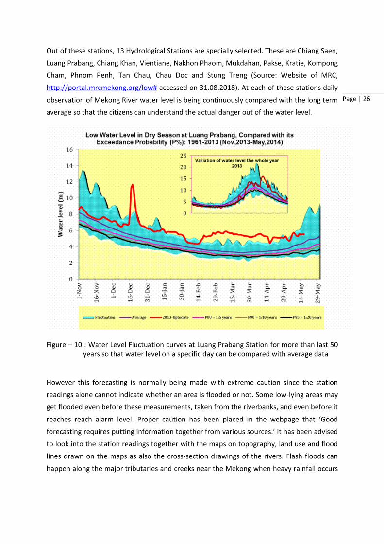
Out of these stations, 13 Hydrological Stations are specially selected. These are Chiang Saen,
Luang Prabang, Chiang Khan, Vientiane, Nakhon Phaom, Mukdahan, Pakse, Kratie, Kompong
Cham, Phnom Penh, Tan Chau, Chau Doc and Stung Treng (Source: Website of MRC,
http://portal.mrcmekong.org/low# accessed on 31.08.2018). At each of these stations daily
observation of Mekong River water level is being continuously compared with the long term
average so that the citizens can understand the actual danger out of the water level.
Figure – 10 : Water Level Fluctuation curves at Luang Prabang Station for more than last 50 years so that water level on a specific day can be compared with average data
However this forecasting is normally being made with extreme caution since the station
readings alone cannot indicate whether an area is flooded or not. Some low-lying areas may
get flooded even before these measurements, taken from the riverbanks, and even before it
reaches reach alarm level. Proper caution has been placed in the webpage that ‘Good forecasting requires putting information together from various sources.’ It has been advised
to look into the station readings together with the maps on topography, land use and flood
lines drawn on the maps as also the cross-section drawings of the rivers. Flash floods can happen along the major tributaries and creeks near the Mekong when heavy rainfall occurs

Page | 27
and the river water starts to back up. These are very hard to predict. As a result, adequate
statutory disclaimers have been used by MRC in this regard.
Hydrology of Mekong River
Unlike Sundarban delta, wherein the quantum of freshwater discharge is not well
documented and for that matter not measured so far, Mekong hydrology is well documented
due to rigorous and continuous studies being carried out by different agencies. It has been
reported that the mean annual discharge of the Mekong is approximately 475 cubic
kilometres (km3) (MRC, 2005). 16% of this discharge amount is from China and only 2% is from
Mynamer. Lao PDR, as a country, is the major contributor of water. Interestingly, the major
left bank tributaries, particularly the tributaries that enter downstream of Vientiane –
Nongkhai contributes about 60% of the discharge, as detailed in the following table:
Table – 9 : Flow Contributions from different areas for mainstream reaches (MRC, 2005)
River Reach Left Bank % Right Bank % Total %
China 16 16
China – Chiang Saen 1 4 5
Luang Prabang – Chaing Khan 1 2 3
Chiang Khan – Vientiane 0 0 0
Vientiane – Nongkhai 0 1 1
Nongkhai Nakhon Phanom 19 5 24
Nakhon Phanom – Mukdahan 3 1 4
Mukdahan – Pakse 5 6 11
Pakse – Stung Treng 23 3 26
Stung Treng – Kratie 1 0 1
Total 60 16 24 100
The above table clearly pointed to the fact that the major flow contributions is from the left
bank tributary systems in Lao PDR and the Se Kong and Se San Rivers which meet the Mekong
River in between Pakse in Southern Laos and Kratie in Cambodia.
Flows at Chiang Saen entering the LMB from Yunnan make up about 15 percent of wet season
flow at Kratie. This rises to 40% during the dry season, even for downstream. It is to be noted

Page | 28
that the major source of water flowing into the river at Yunnan comes from melting snow on
the Tibetan Plateau. This volume of water is sometimes called the “Yunnan Component” and
plays an important role in the low-flow hydrology of the lower mainstream (MRC, 2005). This
is unique of Mekong River and has been studied over a long period of time. That is why there
is significant concern regarding the construction of large scale reservoirs on the Mekong and
its tributaries in Yunnan province, since it may have significant impact on the dry season
hydrology of the lower stream. Mean annual flows along the Mekong River is described in the
following table.
Table – 10 : Lower Mekong Mainstream mean annual flow (1960 to 2004) at selected sites (MRC, 2005)
Mainstream
Site Catchment area km2
Mean annual flow as As % total Mekong
Discharge cumecs
Volume km3 Runoff mm
Chiang Saen 189,000 2,700 85 450 19
Luang Prabang 268,000 3,900 123 460 27
Chiang Khan 292,000 4,200 133 460 29
Vientiane 299,000 4,400 139 460 30
Nongkhai 302,000 4,500 142 470 31
Nakhon Phanom
373,000 7,100 224 600 49
Mukdahan 391,000 7,600 240 610 52
Pakse 545,000 9,700 306 560 67
Stung Treng 635,000 13,100 413 650 90
Kratie 646,000 13,200 416 640 91
BASIN TOTAL 760,000 14,500 457 600 100
There is considerable deforestation in the catchment area of the Mekong River during last 60
years due to many reasons, particularly political unrest, expansion of agricultural area,

Page | 29
population pressure etc. However, ‘it is still unclear how much impact land use changes have
had on the hydrological regime of the Mekong. The removal of so much forest cover would
be expected to result in changes in the rainfall-runoff relationship. …….. There is a lot of
hydrological data, at least for the mainstream, but linking rainfall to stream flow is difficult,
even on an annual timescale. However, no one has yet found any conclusive evidence in the
90 years of historical data for any significant changes in rainfall-runoff relationships’ (MRC,
2005).
It clearly demonstrates that in spite of such robust database, it is becoming difficult to
establish relationship between two natural phenomena. This only indicates the pathetic
condition of Sundarbans, since hardly any data exists there even on discharge of freshwater
along different distributaries in Sundarbans.
Kratie is generally regarded as the point in the Mekong system where the hydrology and
hydrodynamics of the river change significantly (MRC, 2005). Upstream from this point, the
river generally flows within a clearly identifiable mainstream channel. In all but the most extreme flood years, this channel contains the full discharge with only local over-bank natural
storage. Interestingly, Kratie is located at a distance of about 600 kilometres from the point
of discharges of Mekong River at South China Sea. Downstream from Kratie, seasonal floodplain storage dominates the annual regime and there is significant movement of water
between channels over flooded areas, the seasonal refilling of the Great Lake and the flow
reversal in the Tonle Sap. There is extreme hydrodynamic complexity in both time and space and it becomes sometimes impossible to measure channel discharge. Water levels, not flow
rates and volumes, determine the movement of water across the landscape. In case of
Sundarbans, such point of significant changes in hydrology and hydrodynamics needs to be
identified so as to understand the actual freshwater discharge along the Ganga – Padma River System.
Prior to 1960, Discharge Analysis along Lower Mekong River Basin was carried out by Harza
Engineering Company. This Report by Harza Engineering Company was prepared for
Committee for Coordination of Investigation of the Lower Mekong River Basin and the U.S.
Agency for International Development (Bassin du Mekong Inferieur, debits pour 1959 et
Annees Precedentes: Rapport/ Prepare par Harza Engineering Company pour le Committee
de Coordination des Etudes sur le Bassin du Mekong Inferieur et l'Agence des Etats-Unis pour
le Developpement International., Bassin du Mekong Inferieur, Debits pour 1959 et Annees
Precedentes., Discharges prior to 1960, Mekong Basin) and published in 1962. Unfortunately,
copy of this report is available only in hard copy and may be available from MRC Secretariat
on request (Source:

Page | 30
http://portal.mrcmekong.org/search/search?q=discharge+data&format=&max=5&offset=0
&sort=title&order=ASC&t=Stream+measurements++-+Mekong+River+Watershed accessed
on 6th September, 2018). A copy of this report has been digitised and also available in the
Digital Library of Cornell University USA under Natural Resources Section.
Although MRC Secretariat claims to make data collection on different parameters for the
Mekong River and its tributaries on regular basis, but the quantum of data as available does
not points to a very bright picture (Source: http://portal.mrcmekong.org/datacollection
accessed on 6th September, 2018). It appears that the data collected is quite scanty in nature
and is of quite old. It may be possible that the webpage has not been updated properly which
may lead to this confusion.
Table – 11 : Discharge & other data as available from MRC website
Country Discharge at Tributaries (stations)
Discharge at Mainstream
(stations)
Sediment at Mainstream
(stations)
SS GSA at Mainstream
(stations)
Bedload , (stations)
Bed-material
GSA (sites)
Cambodia 7 (2011-12) 6 (2009-13) 6 (2011-13) 2 (2011-13) 1 station, (13
samples)
9 (2011)
Lao PDR 9 (2011-12) 2 (2009-13) 2 (2011-13) 2 (2011-13) n/a 11 (2011)
Thailand 5 (2011-12) 6 (2009-13) 6 (2009-13) 2 (2010-13) 2 stations , (4 samples)
21 (2011)
Vietnam 4 (2011-12) 2 (2009-13) 2 (2009-13) 2 (2010-13) n/a 23 (2011)
Total 25 16 16 8 3 64
Morphology Survey of Mekong River
Till date MRC Secretariat does not have any well defined Morphology Survey of the river, except at pre-determined specific locations. However, The Navigation Programme at the MRC
has requested assistance from the Information and Knowledge Management Programme (IKMP) to carry out baseline channel morphology surveys at a proposed rock removal site near Kong Phi Luang rapids in northern Thailand and Lao PDR (Source :

Page | 31
http://portal.mrcmekong.org/geomorphology_survey accessed on 6th September, 2018).
The planned rock removal is for the purpose of improving navigation safety. There are
concerns that the removal of several bedrock obstructions from the channel may result in
river incision or deposition in surrounding areas. This could potentially lead to exposure of
other bedrock obstructions or detrimental effects on aquatic biota. However, a detailed
baseline morphology survey planning is yet to be carried out. It has been so far planned in a
schematic way. The aims of baseline channel morphology surveys are:
• To collect river channel cross-section profiles that can be compared to repeat
surveys in the future to monitor and mitigate against potential morphological
change;
• To provide input data to hydraulic and sediment transport models that can be used to predict channel incision and deposition. This would enable mitigation measures to
be implemented prior to the removal of rocks.
Water Quality Measurement
MRC started water quality monitoring of Mekong River water from 1985 as per request of
Member Countries. Initially, the water quality Monitoring programme started in Lao PDR, Thailand and Viet Nam. Cambodia joined the programme in 1993. Presently water quality
monitoring is being carried out at 48 permanent monitoring stations, of which 11 are in Lao
PDR, 8 in Thailand, 19 in Cambodia and 10 in Viet Nam. Samples of surface water are taken from the river mid-stream every two months, i.e. six times a year starting from February.
Member Countries may increase the sampling frequency, sometimes 12 times a year, i.e. on
monthly basis, as per latest agreement on ‘Procedures for Water Quality (PWQ) adopted in
the year 2011. Water quality analysis is conducted in designated laboratories.
Out of these 48 sampling stations, 17 are on the mainstream, five on the major tributary
Bassac River, and the remaining stations on other tributaries (MRC, 2018). At each station, 12
water quality parameters (temperature, pH, salinity, acidity, etc.) are analysed on a monthly
basis, and another six parameters (calcium, magnesium, sodium, etc.) are examined during
the wet season from April to October. The biochemical oxygen demand, another parameter,
is assessed monthly at a few selected stations throughout the year. After the quality
assessment, the samples are classified as “excellent”, “good”, “moderate”, “poor” or “very
poor” for human health, and another similar five classifications for aquatic life. The samples
are also analysed for irrigation use. These sampling data are submitted to the MRC Secretariat
annually to verify and store in the database for public access. The MRC Secretariat further
prepares a consolidated annual report, entitled the Lower Mekong Regional Water Quality

Page | 32
Monitoring Report, based on data from the main 22 stations of the Mekong and Bassac rivers
(MRC, 2018).
On the basis of review of scientific literature and statistical analysis of the MRC data, a Water
Quality Index has been designed based on a set of key water quality parameters. The Water
Quality Index shows the pressure exerted by human activities on the water quality of the
Mekong River. The Water Quality Index is calculated each year for 17 stations in the
mainstream of the Mekong River from the Northern Lao PDR to the Mekong Delta.
An informative map on the water quality monitoring has been presented in the website. The map indicates the marker at the location of water quality monitoring stations and the colour
of the marker is based on the Water Quality Index class for 2015, (Source:
http://portal.mrcmekong.org/waterquality_map Accessed on 6th September, 2018)
Table – 12: Details of 22 stations and the water quality at these stations over seven years
Sl. No.
Name of Station Station Id River 2009 2010 2011 2012 2013 2014 2015
1. Houa Khong H010500 Mekong A B A B B C A 2. Chiang Sean H010501 Mekong B B A B B B B 3. Luang Prabang H011200 Mekong A B A B A B B 4. Vientiane H011901 Mekong A B A B B B B 5. Nakhon Phanom H013101 Mekong B B B B B B B 6. Pakse H013900 Mekong A A A A B A B 7. Savannakhet H013401 Mekong A A A B B C B 8. Khong Chiam H013801 Mekong B B A B B B B 9. Stung Trieng H014501 Mekong A A A A A A A 10. Kratie H014901 Mekong A A A A A A A 11. Kampong Cham H020103 Mekong A A A A A A B 12. Chroy Chanvar H019801 Mekong A A A A A A A 13. Takhmao H033401 Mekong A A A A B C A 14. Koh Khel H033402 Mekong A B A B B A B 15. Neak Loung H019806 Mekong A A A A A A B 16. Koh Thom H033403 Mekong A A A B B A A 17. Krom Samnor H019807 Mekong A A A B A A B 18. Tan Chau H019803 Mekong C B B A A A A 19. My Thuan H019804 Mekong B C A A B A A 20. Chau Doc H039801 Mekong C C B A A A A 21. My Tho H019805 Mekong C C B B B B A 22. Can Tho H039803 Mekong B C B A A A A
Class A – No Impact; Class B – Slight Impact; Class C – Impact; Class D – Severe Impact
From the study, it is significant that none of these stations have severe impact as per the
Water Quality Index. Although some of these stations have reached the point of ‘Impact’ but subsequently it was recovered. The map of water quality monitoring is presented below:

Page | 33
Figure – 11 : Map showing Different Water Quality Monitoring Stations with Monitoring Index (Source: http://portal.mrcmekong.org/waterquality_map accessed on 6th September, 2018)
In addition to this water quality monitoring, MRC Secretariat also carries out measurement of
Suspended Sediment Concentration (SSC). MRC has set up simple laboratories in all four member countries based on the agreement between the member countries so that these
countries have the capability on analyzing suspended sediment concentration themselves
using the same standardized analysis techniques and reporting in the same format for better quality-controlled and data use. For this, in Cambodia a simple laboratory was established at
the Department of Hydrology and River Works, while in Lao PDR was established at the
Department of Meteorology and Hydrology. In the Thailand, the laboratory in Chiang Sean was upgraded for SSC analyses, while in Viet Nam the laboratory was established at Chau Doc.

Page | 34
Additional Services of MRC for LMB
Water Extent Mapping is being carried out on regular basis using Remote Sensing Technique.
The near-infrared band (NIR, MODIS band 2) provides the option for water and land boundary
discrimination and thereby helps in mapping the water extent along the flood plains and
wetlands on regular basis.
Global Satellite Mapping of Precipitation (GsMAP) : The amount of rainfall and its spatial
distribution are important for water resources assessment, flood and drought prediction. The
availability of several high resolution global satellite based rainfall products by various
operating agencies, such as Global Satellite Mapping of Precipitation (GSMaP), CMORPH,
TRMM Multi satellite Precipitation Analysis, can provide information on the amount of
precipitation and its spatial distribution in such data sparse regions. Among these, GSMaP
provides the highest spatial resolution satellite-based products at a fine temporal scale. In
order to overcome the shortage of Ground Measuring Stations for rainfall, MRC accepted GSMap with the technical support of JST (Japan Science and Technology) and Japan Aerospace
Exploration Agency (JAXA) as Precipitation Measuring Mission.
Keetch–Byram Drought Index (KBDI) : Typically it is applied in potential wild-fire assessment
in the United States. KBDI reflects water gain or loss within the upper soil column using mean annual rainfall, daily rainfall and daily maximum temperature as input parameters (Keeth &
Byram, 1968). It is ranging from 0 (no drought) to 800 (extreme drought). Since LMB suffers
from freshwater supply during dry seasons, MRC with the help of high resolution satellite data
provides KBDI for different parts of LMB at the time of extreme summer to assist the Governments of the Member Countries to assess the actual drought situation over the areas
under LMB.
Normalize Difference Vegetation Index (NDVI) : Based on the differential ratio of reflectance
in two different spectral bands, which is a standardised remote sensing technique, NDVI
actually represent the presence of green (in other words presence of vegetation) in an area.
Based on MODIS data, MRC provides the NDVI over the entire LMB on regular basis to the
Governments of the Member Countries.
Vegetation Crop Index (VCI) : VCI is an indicator of the vigor of vegetation which covers as a function of NDVI values for a given area. It assesses changes in the NDVI signal through time
due to weather conditions, reducing the influence of ‘geographic’ (Kogan, 1990) or
‘ecosystem’ (Kogan, 1995) variables i.e. climate, soils, vegetation type and topography. MRC carries out VCI determination of LMB for making the assessment regarding crop production
in the Member Countries and provide those data to the respective Government.

Page | 35
Environmental Management
Mekong is the world’s tenth largest river. It is the home to unique, rich and abundant natural
resources such as Pangasianodon gigas, the Giant Mekong Catfish and Orcaella brevirostris,
the Irrawaddy Dolphin (Source : http://portal.mrcmekong.org/river-bio-monitoring accessed
on 6th September, 2018). These natural resources are under threat due to intensive irrigation
for agriculture, a decline in traditional capture fisheries which is being replaced with semi-
intensive to intensive pisciculture, extensive development along the LMB and the threat of
climate change, impact of which is hardly understood at this moment. Thus, there exists a
state of uncertainty regarding the fate of these natural resources.
MRC is looking into these aspects with focus on specific areas such as Climate Change
Adaptation, Fisheries, wetlands and watershed management. The idea is to bring out country
driven strategies with the aim to protect the environment and also to help people to adapt to
environmental uncertainties in a more prepared manner.
Biodiversity
The Mekong basin is one of the richest biodiversity hotspot in the world. Recent estimates
indicated that there is a rich biodiversity in LMB which includes approximately 20,000 plant
species, 430 mammal species, 1,200 bird species, 800 reptile and amphibian species, and 850 fish species. New species in LMB is still getting discovered on regular basis (Source : http://portal.mrcmekong.org/river-bio-monitoring accessed on 6th September, 2018).
Even though there is abundance in concentration in number of different species, some of the species are declining in number and are even threatened due to unsustainable and reckless
behaviour from the part of local residents. This includes even the Giant Catfish of Mekong,
which has been declared as critically endangered species. Many important bird habitats have suffered due to wetland drainage, overgrazing, peat mining, reservoir construction, pesticide
use and changes to agricultural practices. The Mekong Basin is home to some of the world’s
most spectacular amphibians and reptiles, but unsustainable hunting and trading practices have decimated many of these populations.
For biodiversity conservation of Mekong River and the adjoining wetlands, MRC has
undertaken a number of indigenous aquaculture projects under Fisheries Programme. In this
programme, MRC encourages the local farmers to use indigenous species in aquaculture ‘to prevent the spread and dominance of non-native invasive species that threaten biodiversity’
(Source : http://portal.mrcmekong.org/river-bio-monitoring accessed on 6th September,
2018). There is another programme known as Basin Development Programme of MRC
wherein an integrated approach of planning considering all aspects including environmental

Page | 36
impacts, biodiversity loss and its mitigation measures is being implemented. In fact Basin
Development Programme is an extensive programme which encompasses all these aspects
and will be discussed subsequently.
The wetlands of LMB are famous for biodiversity. Tonle Sap River and the Great Lake of
Cambodia, which has been declared as a UNESCO Biosphere Reserve, are particularly
important. In fact, the Giant Catfish of Mekong travels all the way to Yunnan Province of China
for spawning and thus the entire stretch of Mekong River and its different tributaries are
important from the point of view of biodiversity conservation. Apart from providing normal
eco-system services of wetlands such as sediment trapping, nutrient recycling and pollution
removal, surface and ground water storage and carbon capture, these wetlands are the
unique and irreplaceable habitats for countless species of fish, plants and animals, and
essential food and water sources for millions of people in rural communities. MRC has
initiated number of studies under the ‘Environment Programme’ and ‘Climate Change and Adaptation Initiative’ which are expected to provide important results and will help the policy
makers to draw appropriate programmes for protecting these important ecosystems on a
sustainable manner.
Mangroves in Mekong Delta
Mangroves are growing in 123 tropical and subtropical countries (Spadling et al, 2010). There are altogether 73 species of mangroves recognised as “True” mangroves. South-asia has been
recognised as the most important and most diverse mangrove habitat. Out of the South-
Asian countries, Vietnam had considerable mangrove coverage and still there is enough
mangrove coverage especially in South Vietnam. Vietnam belongs to the Indo-Malesian class of the most bio-diverse region in the world (Alongi, 2002). Mangroves in Vietnam are primarily
located in the Southern Vietnam in Mekong Delta and Ca Mau Province. Almost 70% of the
mangroves of Vietnam are located in South Vietnam.
Due to long-term human impact, the density of mangrove vegetation has considerably
changed along the whole southern Vietnamese coastline since the late 19th century,
especially in the area of the Dong Nai River estuary, the Mekong delta and the adjacent
peninsula towards Ca Mau (Mazda et al., 2002; Phan et al., 2015; Schwarzer et al, 2016).
Approximately 42% of the total mangroves in Vietnam have disappeared from 1980 – 2005
(FAO, 2007).
It is estimated that nearly 40% of the mangrove forests in southern Vietnam were destroyed
during the Vietnam War (1962–1971) (Phan and Hoang, 1993). Over 20% of about 600,000 ha
of the total mangrove-forested regions of South Vietnam were defoliated in 1968 by chemical
Page | 37
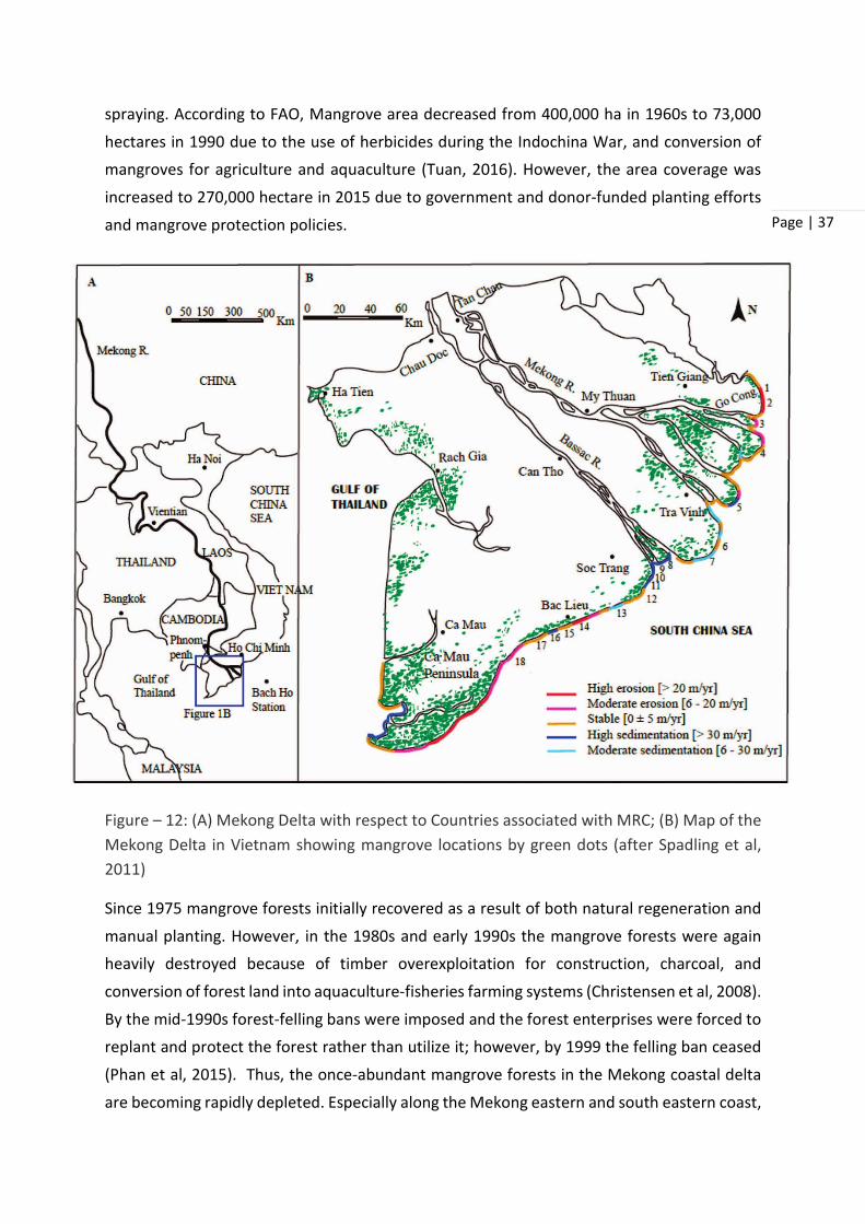
spraying. According to FAO, Mangrove area decreased from 400,000 ha in 1960s to 73,000
hectares in 1990 due to the use of herbicides during the Indochina War, and conversion of
mangroves for agriculture and aquaculture (Tuan, 2016). However, the area coverage was
increased to 270,000 hectare in 2015 due to government and donor-funded planting efforts
and mangrove protection policies.
Figure – 12: (A) Mekong Delta with respect to Countries associated with MRC; (B) Map of the Mekong Delta in Vietnam showing mangrove locations by green dots (after Spadling et al, 2011)
Since 1975 mangrove forests initially recovered as a result of both natural regeneration and
manual planting. However, in the 1980s and early 1990s the mangrove forests were again
heavily destroyed because of timber overexploitation for construction, charcoal, and
conversion of forest land into aquaculture-fisheries farming systems (Christensen et al, 2008).
By the mid-1990s forest-felling bans were imposed and the forest enterprises were forced to
replant and protect the forest rather than utilize it; however, by 1999 the felling ban ceased
(Phan et al, 2015). Thus, the once-abundant mangrove forests in the Mekong coastal delta
are becoming rapidly depleted. Especially along the Mekong eastern and south eastern coast,

Page | 38
mangrove degradation and rapid coastline erosion are observed at many locations (Phan et
al, 2015). Conversion of mangroves for export-oriented intensive shrimp production remains
a substantial threat in many areas (Tuan, 2016). There are many abandoned shrimp farms
with potential for rehabilitation presently occurring in Ben Tre and Tra Vinh provinces in South
Vietnam.
Table – 13 : Distribution and classification of Mangroves in Vietnam
Area Total area (ha) Area by types of Forest (ha) Protection Special – use Production
Vietnam as a Country
209,741 115,950 28,311 65,480
Quang Ninh, Northern region
37,651 30,928 4,489 2,234
Central – northern region
1,885 1,341 – 544
Central – southern region
2 – – 2
Southeast region
41,666 38,468 16 3,182
Mekong river delta
128,537 45,213 23,806 59,518
(Sources : Institute of Forest Inventory and Planning, Vietnam – FIPI)
There are different authorities for looking after mangrove protection and legislation in Vietnam. These are:
1) Ministry of Natural Resources and Environment (MONRE) : • Responsible for land management, mapping and issuing land certificates
• Has departmental offices (DoNREs) at the provisional and district levels for looking after the ground level scenarios
2) Ministry of Agriculture and Rural Development (MARD)
• Responsible for forest and fisheries management, planning and allocation
• Has departmental offices (DARDs) at the provincial and district levels
3) Provincial, district and commune People’s Committees
• Represent the executive arm of the state
• Evaluate and approve MONRE’s and MARD’s land and forest plans
Conservation approaches
The major challenge in Vietnam is that while coastal mangrove areas support large
surrounding populations and diverse economic activities, these in turn drive mangrove loss
(Slayde et al, 2010). The decline of Vietnam’s mangrove forests over the past 50 years

Page | 39
represents a serious environmental and social area of concern. Today, mangrove forests
continue to be converted for development, agriculture, and aquaculture, and degraded by
over-exploitation and pollution. As mangroves are lost, so are associated ecosystem services.
Yet, financial resources to preserve mangroves are often lacking. This lack of funding can be
attributed in part to a systematic undervaluation of mangrove ecosystems, as well as the
reality that limited conservation funding must be shared between various conservation goals.
Hence from a non-governmental approach, an approach known as “PES” (Payment for
Ecosystem Services) was developed for the mangroves of Vietnam and was introduced among
the conservationists of Vietnam, although not of much effect.
A number of Government initiatives have also been undertaken, as given below (after Salyde
et al, 2010):
• In 2005: Law on Environmental Protection requires strategic environmental assessments for land use p l a n n i n g a n d f o r e s t d e v e l o p m e n t a n d p r o t e c t i o n . The Environmental Protection Law of 2005 also specifies that the trading of emissions credits with foreign buyers will be regulated by the Prime Minister.
• National Forestry Strategy for 2006-2020, aims to increase overall forest cover to 47% by 2020, including 5.68 million ha of protection forest and 2.16 ha of special use forest
• In 2008: The Biodiversity Law emphasizes the protection and conservation of biodiversity resources in the country. The law recognizes the environmental value of forests and mangroves and lays a foundation for the development of markets for ecosystem services.
• In 2008: Decision 380 outlines a pilot policy on payment for forest ecosystem services (PFES), under which ecosystem service users pay e c o s y s t e m s e r v i c e p r o v i d e r s f o r t h e v a l u e o f s e r v i c e s p r o v i d e d b y t h e f o r e s t .
• In 2009: The plan for mangrove restoration and development for 2008-2015, approved by the Prime Minister, sets a goal to increase the area of mangrove in Vietnam from 209,741 ha to 307,295 ha, mainly by planting. 29 coastal provinces are subject to this plan. Forest contracting and allocation to local households and communities are prioritized.
• In 2010: The National Strategy for Environmental Protection until 2020 and Vision
Until 2020 sets a goal of increasing overall forest cover 43% by 2020, while

Page | 40
improving forest quality and restoring mangrove forest. The strategy recommends activities to increase mangrove areas to 80% of 1990 levels.
• In 2010: The master plan on development of the fisheries sector until 2020 and vision through 2020 has a goal of promoting sustainable extraction of aquatic products and sustainable aquaculture development across 1.4-1.5 million ha of surface water and production centers in the Red River Delta, southeast region, and Mekong River Delta
• Decree 119/2016/ND-CP. – Policy on Coastal forest management, protection, rehabilitation and development in response to climate chance. (23 August 2016, approved by Prime Minister).
In spite of these initiatives, the mangroves in Mekong Delta is under immense threat since
the mangrove forests in Mekong Delta usually consist of a narrow strip only, sometimes as
narrow as 100 m. Even these narrow strips of mangroves are getting squeezed. This mangrove
squeeze is mainly due to the construction of sea dikes in a quest for the creation of space for cultivation and the prevention of salinity intrusion (Phan et al, 2015). There is a critical
minimum width of a coastal mangrove forest strip to keep its ability to stay stable or, once
surpassing the minimum width, to promote sedimentation. The larger the width the more efficient the attenuation of waves and currents will be, offering both a successful seedling
and sedimentary environment. It has been pointed out that an average critical width of 140
m is found for the south eastern and eastern Mekong Delta coast as a minimum width to sustain a healthy mangrove forest (Phan et al, 2015). Unfortunately, the widths of the
mangroves are getting constricted day by day, which is a real threat in the backdrop of climate
change. Thus, there is a close similarity between the Mekong Delta mangroves and Sundarban Mangroves, since both will not get any further room on the landward side for backtracking in
the face of climate change.
Basin Development Planning
The Lower Mekong Basin is experiencing a rapid development boom. Demand for food, water
and energy will increase as a result of economic growth, industrialisation and urbanisation.
Despite the surge in economic growth, millions of people still live in poverty
(http://www.mrcmekong.org/topics/basin-planning/ accessed on 10.09.18). To a large

Page | 41
extent, sustainable basin planning in LMB is interconnected between poverty eradication and
economic development.
Due to these complexities, there is a call for a coordinated or integrated approach to basin
planning to secure the equitable use of the Mekong’s water resources. This approach is
commonly referred to as Integrated Water Resources Management (IWRM) approach and
aims to support effective and efficient management of water and related resources at the
transboundary and cross-sector level.
The Mekong agreement tasks the MRC to promote optimal use of water and well-balanced
development of the basin, and support the achievement of the Mekong’s full potential
through the formulation of a basin development plan (MRC, 2018). Basin Development plan
is the essential component of the Mekong Agreement. Lower Mekong Basin Development
Strategy has been designed based on Integrated Water Resources Management Approach
(Source: http://www.mrcmekong.org/topics/basin-planning/ accessed on 08.09.18).
It has been envisaged that integrated planning approaches in large and complex river basins
can help ensure effective management and equitable use of water and related resources. This is very relevant for the Mekong River Basin and is the reason behind why an Integrated Water
Resources Management (IWRM) is a cornerstone of the MRC’s approach to management
planning on a basin-wide scale.
Basin Development Strategy
In response to the need to coordinate basin planning at the transboundary, or regional level, the LMB countries adopted the IWRM based ‘Basin Development Strategy’ (BDS) in 2011. The
Strategy sets out how Mekong Countries will share, utilise, manage and conserve the Mekong
water and related resources to achieve the goals of the 1995 Mekong Agreement. BDS was
initially adopted for a period of five years from 2011 to 2015. The MRC Member Countries
had developed shared understandings of the opportunities and risks of the national plans for
water resources development along LMB and agreed on a number of Strategic Priorities to
optimise the development opportunities and minimise uncertainty and risks associated with
them. This provides incentives for the timely implementation of the agreed procedures under
the 1995 Mekong Agreement (MRC, 2011). The MRC Council Members expected that
implementation of the Strategy will promote regional cooperation for sustainable
development of water resources and help to address climate change impacts and protect
ecosystems and livelihoods. They called for the basin’s people to play a central role in the
implementation of the Strategy and highlighted the need for capacity building and joint
learning.

Page | 42
The IWRM-based Basin Development Strategy is a statement of the LMB countries setting out
how they will share, utilise, manage and conserve water and related resources of the Mekong
to achieve the goals of the Agreement for the Cooperation for the Sustainable Development
of the Mekong River Basin, signed on 5 April 1995 (the Mekong Agreement, 1995).
The Strategy is part of the MRC’s commitment to regional cooperation under the 1995
Mekong Agreement, and in particular a response to Article 2 which calls for the formulation
of a basin development plan. It provides initial directions for sustainable basin development
and management that are subject to review and updating by MRC every five years.
The Strategy contributes to a wider adaptive planning process that links regional and national
planning for sustainable development and management of the LMB. It considers projected
development scenarios over a fifty-year period to create a twenty-year view of basin
development and management. It provides an integrated basin perspective against which
current and future national water resources development plans can be assessed to ensure an
acceptable balance between economic, environmental and social outcomes in the LMB, and mutual benefits to the LMB countries, as required by the 1995 Mekong Agreement. The
Strategy:
• defines the scope of opportunities for water resources development (hydropower, irrigation, water supply, flood and drought management), their associated risks and the actions needed to optimise opportunities and minimise risks;
• defines other water-related opportunities (fisheries, navigation, environment and ecosystems, watershed management); and
• provides a coordinated, participatory and transparent process that promotes sustainable development.
Need for the Strategy
Need for the strategy has been clearly mentioned in the BDP Document, 2011. It has been
mentioned that ‘this Strategy has been developed during a time of significant change, where
rapid, large-scale development of the river is already taking place. Hydropower dams
constructed on the Lancang River in China (Lancang-Upper Mekong Basin) and on tributaries
in the LMB are already changing the Mekong’s flow regime. There is increasing demand from
riparian countries, project developers and stakeholders for the provision of an integrated
basin perspective of national water resources development plans and their cumulative impacts. This is particularly true in a planning environment where private sector operations
are a major driver of change’ (MRC, 2018).

Page | 43
The development of the strategy has been considered as an important milestone since for the
first time, the countries have arrived - through discussions, information sharing and
consultation - at a common understanding of each other’s plans for water resources
development, drawing initial conclusions together on likely transboundary impacts,
addressing each other’s concerns, developing a shared understanding of the opportunities
and risks of water resources development and agreeing to a number of Strategic Priorities
and actions to guide future decisions on basin development and management. It is an
important milestone in the history of cooperation under the framework of the Mekong River
Commission (MRC), at a time when the Basin and the Mekong River itself, one of the world’s
greatest rivers, are seeing significant changes. These include demographic, economic, climate
and hydrological changes, influenced by national, regional and global drivers (MRC, 2018).
The Strategy on Opportunities and Associated Risks
There are many LMB water development opportunities that could bring significant benefits
at national and, through cooperation, at regional levels. These opportunities also have significant risks and costs, which must be managed and mitigated, both at the national level,
and where relevant, through cooperation at the transboundary level. The Strategy identifies
the following opportunities and associated risks:
• Considerable potential for further hydropower development in the tributaries, particularly in Lao PDR and Cambodia, requiring harmonised social and environmental standards to ensure sustainability;
• Major potential to expand and intensify irrigated agricultural production to increase food security, including water use from the Mekong mainstream and to combat Delta saline intrusion, subject to LMB coordination and cooperation with other Mekong countries in the sound operation of existing and planned storage dams, to ensure increased, regulated and reliable dry season flows;
• Potential for some mainstream hydropower development, provided that uncertainties and risks are fully addressed and transboundary assessment and approval processes followed; although potential benefits are high, so are potential costs, including transboundary impacts; and
• Potential for other priority water-related developments (e.g. fisheries, navigation, flood and drought management, tourism, and environment and ecosystem management), as well as those beyond the water sector (e.g. other power generation options)
Strategy on Basin Development

Page | 44
The Strategy defines a process to move from development opportunities to implementation
and sustainable development, including the definition of the following Strategic Priorities for
Basin Development (MRC, 2011):
• Opportunities and risks of current developments addressed, including: coordination between LMB countries and cooperation with China achieved, to ensure increased dry season river flows; agreement on the maintenance of flows on the LMB mainstream implemented; and risks of committed projects managed;
• Irrigated agriculture for food security and poverty alleviation expanded and intensified;
• Environmental and social sustainability of hydropower development greatly enhanced;
• Essential knowledge acquired to address uncertainty and minimise risks of identified development opportunities, including knowledge on migration and adaptation of fish, trapping and transport of sediments and nutrients, changes in biodiversity, and social and livelihoods impacts;
• Options for sharing development benefits and risks identified;
• Climate Change Adaptation Strategy prepared and its implementation initiated; and
• Basin planning considerations integrated into national planning and regulatory systems.
Strategy on Basin Management
Under this specific head, Basin Management has been considered as an integral part of Basin
Development for achieving sustainable development and the following points have been
finalised:
• Basin objectives and management strategies defined for water-related sectors, including fisheries, flood and drought management, wetland management and navigation;
• National-level basic water resources management processes strengthened, including water resources monitoring, water use licensing, and data and information management;
• Basin-level water resources and related management processes strengthened, including the implementation of MRC Procedures, state of basin monitoring and reporting, project cycle monitoring, and enhanced stakeholder participation;
• Rigorous basin-wide environmental and social objectives and baseline indicators defined;

Page | 45
• Water resources management capacity building programme implemented, linked to MRC’s overall initiatives and complementary to national capacity building activities
The strategy, thus defined was implemented through a well defined ‘Roadmap’ setting out
priority actions, timeframes and outcomes of Strategy Implementation. Accordingly, the
Roadmap, which was prepared in the year 2011 for a period of five years i.e. 2011-2016 was
termed as ‘Basin Action Plan’ comprising a regional action plan and four complimentary and
consistent national indicative plans, one per LMB country. It was envisaged that the national
indicative plans would comprise those additional actions needed to supplement current
national plans, in order to implement the Strategy; these actions would vary, reflecting
individual country focus areas and priorities.
It was envisaged to update the strategy every five years based on the experience and target
for the coming days. Subsequently, BDS was updated for next five years namely, 2016-2020
based on a long-term outlook and examines long-term needs for the development, of water
resources (MRC, 2016). It focuses on achieving the sustainable development of the LMB and
adapting national plans to address long-term needs and provide a comprehensive response to climate change and other challenges as the central point of the BDS for 2016-2020.
Four Focussed Key Result Areas have been considered in these five-year BDPs so that MRC
can exert its influence to realize its mission and mandate as the regional river basin
organisation to achieve the agreed strategic outcomes. The four focused areas are:
Table – 14 : Four Focussed areas as adopted in Basin Development Plans of the LMB
Focussed Areas Envisaged Outcome
Key Result Area 1: Enhancement of national plans, projects and resources based on basin-wide perspectives
Outcome 1: Increased common understanding and application of evidence-based knowledge by policy makers and project planners
Outcome 2: Environment management and sustainable water resources development optimised for basin-wide benefits by national sector planning agencies
Outcome 3: Guidance for the development and management of water and related projects and resources shared and applied by national planning and implementing agencies
Key Result Area 2: Strengthening regional
cooperation
Outcome 4: Effective and coherent implementation of MRC Procedures by the Member Countries
Outcome 5: Effective dialogue and cooperation between Member Countries and strategic engagement

Page | 46
of regional partners and stakeholders on transboundary water management
Key Result Area 3: Better monitoring and communication of the Basin conditions
Outcome 6: Basin-wide monitoring, forecasting, impact assessment and dissemination of results strengthened for better decision-making by Member Countries
Key Result Area 4: Leaner River Basin Organisation
Outcome 7: MRC transitioned to a more efficient and effective organisation in line with the Decentralisation Roadmap and related reform plans
This plan is now being implemented at this moment along LMB.
Thus, the Basin Development Plan for LMB can be cited as one of the best examples of ‘Water
Diplomacy’ where the neighbouring countries have come together and framed strategies not
for the sustainable utilisation of a river, but also for the entire region based on mutual trust
and combined benefit where the river played the role of ‘common thread’.
Meteorology
There are numerous hydro-meteorological stations already existing and working in the Lower Mekong River Basin (Takao, 2002). All the four countries belonging to MRC are having line
agencies for meteorological observation and data, as follows (MRC, 2014), as follows:
Lao PDR: Department of Meteorology and Hydrology (DMH), Ministry of Natural Resources and Environment Cambodia: Department of Meteorology (DOM), Ministry of Water Resources and Meteorology Thailand: (1) Thai Metrological Department (TMD), Ministry of Information and Communication Technology (2) Department of Water Resources (DWR), Ministry of Natural Resources and Environment Viet Nam: National Hydro-Meteorological Service (NHMS) Ministry of Natural Resources and Environment (MONRE), National Centre for Hydro-Meteorological Service (NCHMS)
Department of Meteorology and Hydrology (DMH), Lao PDR

Page | 47
It works under Ministry of Natural Resources and Environment (MNROE). Lao PDR is a
member of World Meteorological Organisation (WMO) since June, 1955 and is having
Regional Association II (Asia) as per the website of WMO (https://www.wmo.int/cpdb/lao-
people-s-democratic-republic accessed on 11.09.18).
There are altogether 25 Surface and upper-air stations (OSCAR/ Surface) as per specific
website page of Lao PDR of WMO website.
Table – 15 : Details of Surface and Upper Air Stations in Lao PDR
Station Name Index Observing remarks
Attopeu 48957 A, GOS, RBSN(S)
Bounneua 48921 A, GOS
Hat Dokeo 48942 AGRIMET, GOS
Houei–Sai 48926 GOS, RBSN(S)
Luang Namtha (M. Sing) 48924 A, GOS, RBSN(S)
Luang – Prabang 48930 A, GOS, CLIMAT(C), RBCN, RBSN(S)
Nam Thane 48937 AGRIMET, GOS
Napheng (Pakcheng) 48943 AGRIMET, GOS
Oudomxay 48925 A, GOS, RBSN(S)
Paklay 48936 AGRIMET, GOS
Pakse 48955 A, GOS, CLIMAT(C), RBCN, RBSN(S)
Paksong 48956 AGRIMET, GOS
Parkxanh 48945 GOS, RBSN(S)
Phonhong 48941 AGRIMET, GOS
Plaine Des Jarres (Xiengkhouang)
48935 A, GOS, RBSN(S)
Samneua 48928 GOS, RBSN(S)

Page | 48
Station Name Index Observing remarks
Saravane 48952 A, GOS, RBSN(S)
Savannakhet 48947 A, GOS, CLIMAT(C), RBCN, RBSN(S)
Sayaboury 48938 A, GOS, CLIMAT(C)
Seno 48948 A, GOS, CLIMAT(C)
Thakhek 48946 A, GOS, CLIMAT(C), RBSN(S)
Thangone 48944 AGRIMET, GOS
Vangvieng 48939 AGRIMET, GOS
Viengsay 48927 A, GOS, RBSN(S)
Vientiane 48940 A, GOS, CLIMAT(C), RBCN, RBSN(S)
WMO site maintains meteorological data of these stations of Lao PDR. Based on the data available from 1961 – 1990, WMO has produced station-wise charts (Source:
https://www.wmo.int/cpdb/lao-people-s-democratic-republic accessed on 11.09.2018) as
follows:
Figure – 13 : Chart created at the WMO website based on the data from 1960 – 1990

Page | 49
However, not much information regarding meteorological system is available from their
website (http://www.newcdmh.com/newc/index.php accessed on 11.09.18)
A ‘National Early Warning Centre’ (NEWC) is in operation under DMH in a project mode. Its
objective has been indicated as ‘The Greater Mekong Sub-Region (GMS) Flood and Drought
Management and Mitigation Project supports the Government of Lao PDR to undertake
structural and non-structural measures to prepare for and manage disaster risks linked to
floods and droughts. Project interventions, as formulated in the Terms of reference are: (i)
enhance regional data and knowledge for the management of floods and droughts; (ii)
upgrade or develop water management infrastructure; and (iii) prepare communities to
manage disasters such as flood and drought and adapt to climate change.’ (Source :
http://www.newcdmh.com/newc/index.php/about-us/national-early-warning-centre-
newc accessed on 11.09.18) .
It has been indicated that reliable hydro-meteorological data and the development of an
effective early warning system are essential to mitigate the losses from flood and drought
disasters. To achieve this goal, improvement of the hydro-meteorological network,
effective data transmission and management system, development of forecasting models,
early warning and public awareness, as well as effective communication system are necessary, which have been included as the target for the DMH.

Page | 50
Figure – 14 : Schematic Diagram showing the Early Warning System in Lao PDR
Two priority basins for hydro-meteorological data collection and early warning system
development are: The Sebangfai and the Sebanghieng River Basins. These two basins are
among the most flood affected river basins in Lao PDR.
There is an Early Warning System Mechanism already adopted by DMH. The Early Warning
System Mechanisms are an integrated set of steps starting from the (i) the data acquisition
from the field stations, (ii) the treatment of the information through the operational hydro-
meteorological model and (iii) the delivery of the information to the relevant authorities with appropriate messages and appropriate supports.
The data processing system, the modelling tools and the web portal have been integrated in
order to get a process that is automatized to the extent possible for providing information to
the end-users in a timely and reliable manner.
There are altogether 14 hydrological stations along Sebangfai and Sebanghiang River basins, out of which eight stations have been indicated in the website as Automatic Hydrological
Stations, as below:
1) Sobnam
2) Xelanong
3) Ban Dong
4) Sethamouak
5) Keng Done
6) Xieng Hom
7) Ban Kengkok
8) Dong Hene
There are two Automatic Weather Stations (AWS) which are 1) Savannakhet-Seno and 2)
Dong Hen. The locations of all the Automatic Hydrological Stations and AWS have been shown
on the map and displayed on the website.
However, it is to be noted that Department of Meteorology and Hydrology does not have any
specific programme with focus on Mekong River, although almost the entire Lao PDR is included within LMB.
Department of Meteorology (DOM), Cambodia

Page | 51
The Ministry of Water Resources and Meteorology (MOWRAM) was created in Cambodia
the year 1999. Its main objective is to address political and scientific issues, as stated below:
• Establish the position of the government in terms of political and strategic orientations with respect to both the water resources availability for local development, and its sustainability at national and international scale,
• Carry out scientific research on the potential of underground and surface water resources to establish scientific knowledge on the topic,
• Set directions and roadmap at short, medium and long term with respect to water consumption to fulfil the needs of the country’s development, of the industry and preserve those of urban and rural populations,
• Control and monitor all activities consuming water to mitigate incurred risks,
• Prepare and draft laws and regulations linked to the use of water and control procedures,
• Gather documents and build a technical database about climate and hydrology regarding water uses nationally and abroad, find return on investment for the scientific research,
• Raise the awareness of the industry, NGOs, civilian communities and populations about the development and the exploitation of water resources, and advise them technically on the matter,
• Communicate and validate innovative techniques with respect to the use of water use and its treatments,
• Collaborate and participate in the management of the Mekong Basin, considering both management of water resources and meteorology.
The ministry is composed of ten departments and one technical centre:
Administration and Human Resources Planning and International Cooperation Finance Management and conservation of water resources Hydrology and river work Meteorology Irrigation Clean water and sanitation Engineering Community of water users

Page | 52
Technical center of irrigation and meteorology. The ministry has local representatives called "Provincial Department of MOWRAM", in the
24 provinces to ensure local actions. Among 1400 employees working at the ministry, 662
people are located in Phnom Penh.
Missions of the Department of Meteorology:
• To prepare short, medium and long term plans for rehabilitation and development of meteorology abilities throughout the country.
• To establish and manage the Cambodian meteorological stations.
• To provide weather forecast in short and long time range for all concerned sectors.
• To predict abnormal meteorological phenomenon and emit alert to enable the setting up of protective procedures.
• To raise knowledge and communicate with national and international actors on meteorology technologies.
• To strengthen and broaden Cambodian cooperation on meteorology with meteorological organizations, United Nation agencies and World Meteorological Organization.
• To prepare annual reports on the situation of meteorology in the Kingdom of Cambodia.
Radar Station as Weather Station
In June 2010, Government of Cambodia decided in modernization of meteorological
predications in Cambodia. The objective is to enable the department of meteorology to produce and broadcast weather forecasts thanks to high-performance facilities.
Following this decision, a "Doppler weather radar meteo 650C” was installed. The Radar
Station TECHO SE is located in Phnom Penh, and started operation in April, 2012. The height
of the hexagonal building is 50.60 m (for a total height of 60.60 m if one includes the radar
protection ball). It has a diameter of 24.48 m, 13 floors with 5 dedicated to offices and to the
weather prediction centre.
Cambodia is a member of WMO from November, 1955 and is partner of Regional Association
II i.e. Asia. There are altogether 24 Surface and upper-air stations (OSCAR/ Surface) as per
specific website page of Cambodia in WMO website (https://www.wmo.int/cpdb/cambodia), as below:
Table – 16 : Details of Surface and Upper Air Stations in Cambodia

Page | 53
Station Name Index Observing remarks
Banteay Meanchey 48969 GOS, RBSN(S)
Battambang 48962 GOS, RBSN(S)
Kampot 48985 GOS, CLIMAT(C), RBSN(S)
Kandal 48990 GOS, RBSN(S)
Koh Kong 48986 GOS, RBSN(S)
Kompong Chnang 48967 GOS, RBSN(S)
Kompong Speu 48992 GOS, RBSN(S)
Kompong Thom 48965 GOS, RBSN(S)
Kompong-Cham 48995 GOS, RBSN(S)
Kos Kong 48982 GOS
Kratie 48970 GOS, RBSN(S)
Mondol Kiri 48971 GOS, RBSN(S)
Pailin 48963 GOS, RBSN(S)
Phnom-Penh (Khmough)
48991 A, WT, GOS, CLIMAT(C), RBCN, RBSN(S)
Preah Vihear 48964 GOS, RBSN(S)
Prey Veng 48997 GOS, RBSN(S)
Pursat 48968 GOS, RBSN(S)
Rattanakiri 48973 GOS, RBSN(S)
Sen Monorom 48978 GOS
Siemreap 48966 A, GOS, CLIMAT(C), RBCN, RBSN(S)
Sihanouk Ville 48983 C, GOS, RBSN(S)
Stung Treng 48972 GOS, RBSN(S)

Page | 54
Station Name Index Observing remarks
Svay Rieng 48998 GOS, RBSN(S)
Takeo 48993 GOS, RBSN(S)
In the website as also related documents, no focus has been observed on LMB by Cambodia,
although most of these stations including the Radar Station is located on LMB. That may be
reason for not mentioning LMB separately.
Thai Meteorological Department (TMD), Thailand
In 1905, meteorology was first introduced to Thailand in the field of navigation (Source :
https://www.tmd.go.th/en/ accessed on 11.09.2018). Thereafter, meteorology was continuously used for advancement in navigation also. Thailand’s first Meteorological Service,
known as the Meteorological and Statistics Section, was established in 1923, attached to the
Water Management Division of the Royal Irrigation Department under the Ministry of Lands
and Agriculture. Observation Centres were set up in many provinces for the collection of
rainfall and temperature data, for construction of water gates and for drainage and reservoir
management.
In August 1936, the Meteorological and Statistics Section of the Royal Irrigation Department
was transferred to the Hydrographic Department of the Royal Thai Navy, being currently known as the Meteorological Division. Realizing its increasing importance for various national
activities, the Meteorological Division was promoted to the level of a Department in June
1942. Later, the Department was transferred from the Royal Thai Navy to the Office of the
Prime Minister in the year 1962.
Awareness regarding increasing importance of the application of meteorology to various
fields of human activity, particularly agriculture, water resources development, land
transportation, shipping and aviation, and also the increasing responsibilities of many
Government units under the Office of the Prime Minister, resulted in the Meteorological
Department being transferred from the jurisdiction of the Prime Minister to that of the
Ministry of Transport and Communications in October, 1972. In the year 2002, the Thai
Government reformed the Government System, resulting in the Meteorological Department
being transferred to be under the Ministry of Information and Communication Technology
starting from 3rd of October, 2002, which indicates that the Government’s willingness to
communicate the meteorological information to public end on a fast mode.

Page | 55
The involvement of the Department in the international aspects of meteorology has grown
steadily over the years since its adherence to the Convention of the World Meteorological
Organization (WMO) in 1949. It is worth mentioning that when it joined WMO on 13 May,
1949, Thailand became the nineteenth member of the organization. Today there are 178. Its
participation in many of the programmes of WMO, and notably the World Weather Watch
(WWW) and the Tropical Cyclone Programme (TCP), has ensured its continuing development
in keeping abreast of the latest technological advances. Thus, the importance of meteorology
and its practice are quite known to Thailand over a long period of time.
Vision and Mission of TMD
TMD’s missions have been designed to carry on meteorological administrations and
managements with two vital objectives : (1) the best economic, social, agricultural and industrial benefits and (2) protection of human lives and properties possessed by public
members, private sectors and governmental units against natural disasters. It has been
entrusted by the Thai Government to perform the following five duties:
1. To supply weather forecasts for the entire country and publicize disaster warnings to fulfil the requirement from administration and management in natural disaster mitigation
2. To build people’s awareness toward natural disasters; enable them to perform correct surviving practices; and reduce effects from natural disasters by using modern technologies together with IT services
3. To become the meteorological IT data and service centre at the national level for users in any ventures
4. To improve and develop the Departments research works
5. To strengthen the Department’s roles in international cooperation concerning meteorology and environment with the purpose of profound comprehension on changing world situation.
According to the government gazette, published in 2002, the Thai Meteorological
Department comprises 2 units, 1 office, 2 divisions, 4 bureaux, and 5 centres. The
Meteorological Department, which is responsible for looking after climate related issues,
plays important role in weather monitoring, study and analyze the climate at all times as well as improving and developing the climate forecast to be more effective. It also publishes
climate information and advises on climate change and related agencies for the benefit of
planning and decision making, to alleviate the impact of natural disasters and climate change and the loss of the least. Meteorological Department has set up a climate centre

Page | 56
(http://climate.tmd.go.th/gge/Page%20english.html) as an internal agency for carrying out
studies and research on the current climate change situation.
Climate Centre
There are important climate variables that affect the environment and the lives of humans, animals and other organisms. The Climate Centre serves as the centre and source of climate
information in the country to disseminate climate information to the public and relevant
agencies for the benefit of planning and decision making.
The Climate Centre has been entrusted with the following responsibilities:
• Follow up, analyze and report local weather in Thailand and include the impact of weather in those reports
• Preparation and dissemination of news and academic papers on climate, meteorology.
• Long term weather prediction by analyzing the output from the model, meteorological and climatic data
• Assessing Climate change by researching and developing technologies suitable for Thailand.
• Cooperate with relevant agencies both in and abroad to follow the progress
• Develop long-term weather forecasts and climate change
• Act as a source of climate information in Thailand, by collecting, compiling, and producing climate information reports
• Provides information services to the general public and related organisations/ institutions
Climate Centre Operates under the WMO framework and works in the following fields:
1. Climate data management and climate change management
2. Climate monitoring and assessment
3. Climate product and service Productivity and climate services
4. Climate change information for adaptation and risk management
It also works with the following strategies:
Strategy 1: Leading technology transfer in the development of climate change models.
Strategy 2: Promote proactively on climate change
Strategy 3: Create a service receiver network on weather condition

Page | 57
The website of Climate Centre is quite rich. There is a detail discussion in the webpage in a
separate section on “Climate Change of the World and of Thailand”. On a dropdown menu
basis, the following issues are covered, as follows:
a) Climate Change
b) Green house effect
c) Global Warming
d) Impact of Climate Change on human Hygiene
e) Impact of climate change on food production
f) Climate change and climate change in the World and Thailand
g) Impact of Climate change on the rise of sea level
h) Climate change projection product by Metview
i) Climate Change Data Kit
j) Climate Change Poster etc.
Although these sections are all written in local language, but it provides the option for online
translation in English and thereby helps in understanding of the write-ups. The write-ups here are mostly generic in nature, but extensive and thereby will help the common people and the
stake holders to understand these issues, which is extremely important in the present
backdrop of climate change.
Similarly, there are other sections like “Climate Monitoring” describing issues like :
a) Climate statistics for the period of 30 years 1981 – 2010
b) Climate Statistics
c) Provincial Weather
d) Tropical cyclone statistics
e) Tropical Statistics (map)
However most of the write up, except the ‘Map’ section, has been written in local language and without any provision of online translation (PDF documents), which makes it difficult to
understand by the others belonging to other part of the Globe.
Under “Weather summary” section, the following issues are described in local language
without any option for translation, as follows:
a) Weekly Weather Summary (Every Monday)
b) 7 Day Weather Summary (Every Friday)
c) Monthly Weather Summary

Page | 58
d) Annual weather summary
However, since these are written in local language, these can be easily understood by the
local people, who are the main stake holders.
“Long term weather forecast section” deals with the following issues, once again in Thai
language :
a) Weather Forecast
b) 4 week weather forecast
c) 1 month weather forecast
d) 3-month weather forecast
e) Seasonal weather forecast
f) Weather Forecast for Tourism
There are also sections like ‘Modelling Climate Forecast’, ‘Natural phenomena’, ‘Climate
Index’, ‘Articles/ Academic Documents’, ‘Report on Natural Disasters in the country’ ‘Online Questionnaire’ etc.
Under Climate Section (Source : https://www.tmd.go.th/en/ accessed on 11.09.18), there are
four subsections namely,
a) Daily Weather Summary
b) Weekly Weather Summary
c) Monthly Weather Summary
d) Yearly Weather Summary
In Weekly Weather Summary, weather conditions of different parts of the country have been
described like (i) Northern Part,(ii) North-eastern Part, (iii) Central Part, (iv) Eastern Part, (v)
Southern Part (East Coast), (vi) Southern Part (West Coast) and (vii) Metropolitan (Source :
https://www.tmd.go.th/en/climate.php?FileID=3 accessed on 11.09.2018)
Under Weather Section, General Weather Situation and other details of (i) Thailand (overall
scenario), (ii) Northern, (iii) North-eastern, (iv) Central, (v) East, (vi) Southern (East Coast) and
(vii) Southern (West Coast).
There are altogether 24 (Twenty Four) number of Radars under Thai Meteorological
Department which have been given in TMD website. These Radar Stations are:
1. Chiang Rai
2. Lamphun
3. Nan (120)

Page | 59
4. Nan (240)
5. Phitsanulok
6. Khon Kaen
7. Sakon Nakhon
8. Uban Ratchathani (120)
9. Uban Ratchathani (240)
10. Surin (Mobile Radar)
11. Chainat
12. Samut Songkharam (120)
13. Samut Songkhram (240)
14. Suvarnabhumi (120)
15. Suvarnabhumi (240)
16. Rayong
17. Huahin
18. Chumphon
19. Surat Thani
20. Phuket (120)
21. Phuket (240)
22. Krabi
23. Sathing Phra
24. Narathiwat
Individually, all these Radar Stations have long range and thus the weather prediction system
of TMD is quite robust.

Page | 60
Figure – 15: Area Coverage of the Radar System at Chainhat (Source:
http://weather.tmd.go.th/chn.php accessed on 13.09.2018)
In some cases even the area coverage by the individual radars are also written in Thai
language and only understandable by the local people.
Simultaneously with it, there is a specific section known as ‘TMD Radar Loop’, wherein the
movements of Electromagnetic waves from and to the radar have been displayed in an
animated manner for altogether 18 Radar stations, out of the 24 stations mentioned above.

Page | 61
Figure – 16: Area Coverage of the Radar System at Suvarnabhumi (Source:
http://weather.tmd.go.th/svp120.php accessed on 13.09.2018); written in Thai Language
The website also displays five more information under a dropdown section entitled “TMD
Radar Composite”, as given below:
1. Nationwide Composite
2. Nationwide Composite Loop
3. Nationwide QPE
4. Nationwide QPE Loop
5. Nationwide QPE ASCII File
However, whatever drawings and charts are there under these five sections are all in Thai
language and so it became difficult to understand by anyone who does not know Thai
Language.

Page | 62
It is interesting to note that there are two other sections of Radar are described in the
website. These are (1) Bangkok Radar (under which two more radars have been mentioned –
Nongchok and Nongkhame) and (2) Rainmaking Radar (under which five more radars have
been mentioned – Omkoi, Rong Kwang, In Buri, Pimai and Sattahip). These seven radars do
not belong to normal weather radar system of Thailand but are ‘the result of radar stations
under the jurisdiction of Bangkok and the Royal Rain and Agricultural Aviation respectively’
(Source : http://weather.tmd.go.th/disclaimer.html accessed on 13.09.18) incidentally, this
particular project is famous and innovative for making artificial rain as initiated by the King of
Thailand in the year 1955 and has recorded considerable success.
Weather Warning Announcements are normally published four times a day, i.e. at 5-00 am,
11-00 am, 5-00 pm and 11-00 pm (Local Time) on regular basis. However, all those bulletins
available in the website are in Thai Language.
Department of Water Resources, Thailand
Department of Water Resources, Government of Thailand (Webpage :
http://news.dwr.go.th/index.php ) is also actively involved in providing meteorological
services. As the name signifies, the entire service provided by the department is related to
Water related service only. The official Mission of the department is to create ‘Integrated Water Management System – at National and International Level’.
The contents of the website are mainly in Thai Language and thus it is difficult to go through
the documents loaded in the website. However, the headings of different sections from the
website can only be readable. As per the headings, it seems that there is a specific section with the name “Water Situation” (webpage : http://news.dwr.go.th/situation.php?
category_id=26 ). Within this section, on each day one or two bulletins on water situation of
the country has been uploaded to inform the citizens. Although, numbers of such reports are there including the recent ones, it was not possible to understand any of these reports due
to language barrier.
Another webpage (http://news.dwr.go.th/situation.php?category_id=23 ) on “Toll Station
Report” described the water availability status in different watersheds like Yom Watershed, Nan Watershed, Songkhla Lake Watershed, Bang Pakong River Basin – Prachin Buri, Chao
Phraya River Basin, Sakae Krang River Basin, Pa Sak Waterfall, Wang River Basin and Ping River
Basin etc. Statuses of water in all these nine watersheds are uploaded on a single day, i.e. 11th
September, 2018. Each of these reports is quite detail in nature and seems to be informative
also since average size of these reports are 15 to 20 pages in length containing maps, charts
and graphs, although could not be understood due to language barrier.

Page | 63
The webpage entitled “CCTV Water Level” (http://news.dwr.go.th/situation.php?
category_id=21 ) describes the condition of water as recorded by CCTV in different rivers as
recorded from the bridges over these rivers at several points on daily basis. Every day, a detail
report is prepared with the CCTV pictures at different points from different bridges, which is
uploaded in the webpage. As for example, on 11th September, pictures of water level at 45
(Forty Five) different bridges spreading over entire Thailand have been published, although
could not be understood due to language problem.
Early warning webpage (http://news.dwr.go.th/situation.php?category_id=61) publishes the
“Report on the status of Rainfall and Precipitation” on a specific day, also in the local
language. In the webpage “24 hour water monitoring report”
(http://news.dwr.go.th/situation.php?category_id=49 ) Water monitoring report for last 24
hours are uploaded two times at morning 8-00 hrs and at 3-00 pm on each day. Some
reference of Mekong River Commission (MRC) is also there, but all the reports are in Thai language only.
DWR also has a ‘Drought Management’ (http://news.dwr.go.th/situation.php?
category_id=31 ) programme also. It seems that in certain years, when such situation arises,
then the department initiates such programme and prepare the ‘Integrated Water Situation Plan’ and/or ‘Drought Management’ as happened during February’2015 and April’2012
respectively. However the contents of these reports could not be ascertained.
Thus, it seems that Department of Water Resources also provides a number of hydro-
meteorological services which are important for water resources of Thailand as also for the
Mekong River, which is the major river in this country.
National Hydro-Meteorological Service of Viet Nam
The National Hydro-Meteorological Service (NHMS) is a state operational institution under
Ministry of Natural Resources and Environment (MONRE) and works to assist the country in managing and exploiting the national hydro-meteorological station networks (including
meteorological and hydrological basic investigations, forecasts, documentation), carrying out
observations on air and water environment for disaster prevention and preparedness, socio-
economic development, to ensure security and defence etc. all over the country.
Vietnam is a member of WMO since July, 1975. National Hydro-meteorological Service is the
Hydrological advisor and Meteorological Authority and is the Meteorological Service Provider
in Vietnam as per website of WMO.

Page | 64
There are altogether 8 (eight) Institutional units under NHMS of Vietnam, which are: i)
National Centre of Hydro-Meteorological Forecasting (NCHMF), ii) Hydrological,
meteorological and environmental station network centre, (iii) Aero-meteorological
observatory, (iv) Center for Hydrological and meteorological Information Technology, (v)
Hydro-meteorological Data Centre, (vi) Center of Technological Application and Training for
Hydro-meteorology and Environment, (vii) Hydrometeorology Survey Department and (viii)
Scientific and Technical Hydro-Meteorological Journal. There are also 9 (nine) Regional Hydro-
meteorological centres working under NHMS. These are (1) Tay Bac ( in Northwest), (2) Viet
Bac (in Mid Northern), (3) Dang Bac (in Northeast), (4) Dong Bang Bac Bo (in Red River Delta),
(5) Bac Trung Bo (in North Central), (6) Trung Trung Bo (in South Central), (7) Nam Trung Bo
(in South Central), (8) Tay Nguyen (in Central Highland) and Nam Bo (in Southern Vietnam).
There are 54 provincial hydro-meteorological forecasting centres and observation station
networks also distributed all over Viet Nam.
In Vietnam, altogether 174 Meteorological stations are there, divided into 3 classes:
Class 1 Type: Weather watch: 24/24 hrs
Observation parameters: Wind (direction &speed), Rain fall, Air pressure, Air Temperature, Humidity, Sunshine, Evaporations, Land Temperature (ground and deep layers); Cloud, Visibility, Ground conditions, Radiation (at some stations).
Data collection & transmission: 8 times/day
Class 2 Type: Weather Watch: 24/24 hrs Observation Parameter : Same as class 1, but not doing the observation of radiation, air pressure (at some stations)
Data collection & transmission: 4 times/day Class 3: Weather Watch: 24/24 hrs
Observation Parameter : Same as class 2, but not doing the observation of air pressure.
Data collection & Transmission : 2 times/day Out of these 174 stations in Vietnam, number of different class of stations is as follows: Total : 174 Stations
• Class 1 : 58
• Class 2 : 70
• Class 3 : 46

Page | 65
• Synoptic : 174
• Radiation : 13
• Agro. Met : 27
• GSN : 25
National Centre for Hydro-Meteorological Forecasting (NCHMF) is a governmental
organization belonging to Vietnam Meteorological Hydrological Administration (VMHA) with
authority to issue forecasting/warning information for weather, climate, hydrology, water
resource, marine weather (i.e. hydro-meteorology) and provide hydro-meteorology services
(http://www.nchmf.gov.vn/web/en-US/105/92/Default.aspx accessed on 13.09.2018). It
works with the vision to become ‘the leader in the Southeast Asian region in weather and
climate services to save people and society’.
NCHMF works with the following duties and responsibilities:
1. To develop and implement the standardized operational procedures, standards,
technical regulations, the quota for economy-technology, projects, programs on hydro-meteorological forecasting.
2. To establish, operate, and exploit the national hydro-meteorological forecasting
and warning services; provide the guidance for the provision and usage of hydro-
meteorological forecasting information, hydro-meteorological disasters warning.
3. To monitor, summarize and report about national hydro-meteorological condition, hazard and climate change as well as climate change trend in Asia region and over
the world.
4. Organizing operational hydro-meteorological forecast activities including:
a) Forecasting tropical cyclones and tropical depressions; heavy rainfall; cold
surge and associated weather such as: very cold weather, frozen, frost; heat
wave and very hot weather; thunderstorms, gusty winds, tornadoes,
lightening, hail and local heavy rainfall; flood and inundation; flash flood,
landslide caused by heavy rain or runoff; drought; saltwater encroachment;
high wave and storm surge caused by tropical cyclone and strong monsoon, tide, coastal fog and other hazardous hydro-meteorological phenomena.
b) Forecasting the risk level for hydro-meteorological related phenomena.
c) Forecasting 10-day weather conditions on land and over ocean.

Page | 66
d) Forecasting monthly, seasonal meteorological conditions as well as climate
condition and the trend of climate change, trend of climatic variations.
e) Forecasting short, medium range and monthly, seasonal hydrological
conditions as well as water resources for river basins in Vietnam.
f) Forecasting 10-day, monthly marine conditions as well as sea level trend
caused by climate change in coastal areas of Vietnam.
5. Issuing and transmitting the forecast bulletins for meteorology, hydrology, hydro-
meteorological related hazard and risk levels in Vietnam
6. Implementing hydro-meteorological forecast for meteorological, hydrological
phenomena and hazard as a member of regional and international organizations if
assigned by the Administrator of VMHA.
7. Developing the standardized national climate dataset and the National Framework
for Climate Services for Vietnam.
8. Developing radio, television programs, websites for meteorological hydrological
phenomena and hazard forecast and warning; participating in public education on meteorological, hydrological forecast and warnings.
9. Participating in operational hydro-meteorological forecasting, guide, examine,
monitor and technical training for regional and provincial centers; supervising the
outside hydro-meteorological forecasting activities including other ministries, local governments and individuals and private companies, if assigned by the
Administrator of VMHA.
10. Participating in the process of document verification of the provision, extension,
suspension, withdraw the permits of hydro-meteorological forecasting and warning
activities as well as weather inducing plan, if requested by the Administrator of VMHA.
11. Conducting research, application and technology transfer of new hydro-
meteorological forecasting, if assigned by the Administrator of VMHA.
12. Implementing the international cooperation programs on hydro-meteorological
forecasting, if assigned by the Administrator of VMHA.
13. Providing the meteorological, hydrological and marine services for agencies,
organizations and individuals.

Page | 67
NCHMF has the role of providing the meteorological background forecast for the entire
Vietnam and Bien Dong Sea (the east sea of Vietnam). After receiving the background
forecasts, the regional centres or provincial centres will add more detail forecast and warning
for areas for which these centres are responsible.
The Main functions of NCHMF are as follows:
1. Formulating annual and long-term strategies, programs, plans related to hydro-meteorological forecasting.
2. Formulating regulations, rules, socio-technical standardization on hydro-meteorological forecasting.
3. Regular monitoring of the hydro-meteorological conditions over the entire country and related areas.
4. Issuing hydro-meteorological forecasts, warnings and advisories as assigned for disaster prevention and preparedness, socio-economic development, and national defence security.
5. Establishing and managing a telecommunication network to meet the requirements of hydro-meteorological forecasting in exchanging and transmitting hydro-meteorological data.
6. Providing consultancy and services on hydro-meteorological forecasting to organizations and private sectors under the current laws.
7. Carrying out researches and applications of new technologies on hydro-meteorological forecasting.
8. Supplying instructions on operational hydro-meteorological forecasting and telecommunication; and validating the implementation of these instructions at Regional and Provincial Hydro-meteorological Centers.
9. Organizing training courses on operational hydro-meteorological forecasting and telecommunication.
10. Accomplishing international cooperation projects and programs on hydro-meteorological forecasting, data transmission and other related issues.
In NCHMF, the operational Numerical Weather Prediction (NWP) web portal system named
MHDARS is used to provide the forecasters all NWP related products. There is a web portal
for Severe Weather Forecasting Demonstration Project (SWFDP) In Southeast Asia (SWFDP –
SeA) of World Meteorological Organisation (WMO). In some aspects, the SWFDP-SeA web
portal (http://www.swfdp-sea.com.vn) has some features of the NCHMF web portal but it focuses on the risks of heavy rainfall and strong wind and the confidence level of the risk areas
guiding from deterministic/ensemble global and regional Numerical Weather Prediction
(NWP) models. NHMS and NCHMF will host this system in coming years, as per the website.
Terefore the SWFDP-SeA web portal is like an advanced version of MHDARS for sub centers.

Page | 68
The regional and provincial centres have been accessing the SWFDP-SeA web portal since
2011.
There are a lot of NWP products from different international centres and at different scales.
Therefore the forecasters do not have enough time to look at all of the products. For that
case, the risk maps with confidence degree tables are quite useful for forecasters to know the
uncertainties of the model forecasts or the high variable weather situations and reducing the
possibility of unnecessary focusing too much on only one model.
There are altogether 27 Surface and upper-air stations (OSCAR/ Surface) as per specific
website page of Vietnam of WMO website (https://www.wmo.int/cpdb/viet-nam). Details of
these stations are given below:
Table – 17 : Details of Surface and Upper Air Stations in Vietnam
Station Name Index Observing remarks
Bach Long VI 48839 GOS, RBSN(S)
Ca Mau 48914 GOS, CLIMAT(C), RBCN, RBSN(SP)
Cao Bang 48808 GOS, CLIMAT(C), RBCN, RBSN(S)
Con Son 48918 GOS, RBSN(S)
Da Nang 48855 GOS, GSN, CLIMAT(C), RBCN, RBSN(ST)
Dong Hoi 48848 GOS, CLIMAT(C), RBCN, RBSN(S)
Ha Dong 48825 GOS, RBCN, RBSN(S)
Ha Noi 48820 GOS
Hoang Sa (Pattle) 48860 GOS, RBSN(S)
Hue 48852 GOS, CLIMAT(C), RBCN, RBSN(S)
Huyen Tran 48919 GOS, RBSN(S)
Lang Son 48830 GOS, CLIMAT(C), RBCN, RBSN(S)
Lao Cai 48803 GOS, RBSN(S)

Page | 69
Station Name Index Observing remarks
Nam Dinh 48823 GOS, RBSN(S)
Nha Be 48894 GOS, RBSN(S)
Nha Trang 48877 GOS, CLIMAT(C), RBCN, RBSN(S)
Phan Thiet 48887 GOS, CLIMAT(C), RBCN, RBSN(S)
Phu Lien 48826 GOS, CLIMAT(C), RBCN, RBSN(S)
Phu Quoc 48917 GOS, CLIMAT(C), RBSN(S)
Quy Nhon 48870 GOS, CLIMAT(C), RBCN, RBSN(S)
Son La 48806 GOS, CLIMAT(C), RBCN, RBSN(S)
Song Tu Tay (South West Cay)
48892 GOS, RBCN, RBSN(S)
Tan Son Hoa 48900 GOS
Thanh Hoa 48840 GOS, CLIMAT(C), RBCN, RBSN(S)
Tho Chu 48916 GOS, RBSN(S)
Truong Sa 48920 GOS, RBCN, RBSN(S)
Vinh 48845 GOS, CLIMAT(C), RBCN, RBSN(S)
As per the WMO site, there are two radar stations in Viet Nam. These are at (1) Dong Ha (
Lat 160 48’ 0” N, Long 1070 5’ 0” E) having ground height of 70 metres and (2) Viet Tri (210 28’
0” N, Long 1050 25’ 0” E) having ground height of 200 meters and located near Hanoi. Both
the radars are located in North Vietnam.
Going by the locations, these radar stations seem to be not of so relevance for LMB. However,
data collected and distributed by Highland Regional Hydro-Meteorological Centre (HRHMC)
and Southern Regional Hydro- Meteorological Centre (SRHMC) is quite important for the LMB,
although these data are not available in the website.
In the website of NCHMF, although there is option of forecasting under Hydrology section in
different parts of Vietnam like Southern part etc, it seems not so much effective. Thus, from

Page | 70
the published data and website, it is not clear whether NCHMF carries out any special
arrangements for dissemination of meteorological data for LMB itself. But, several reports of
MRC clearly indicated that such types of arrangements are there in all four countries, as
discussed in the following part.
Meteorological Stations in LMB in a Comprehensive Manner
Japan International Cooperation Agency (JICA) and MRC comprehensively reviewed the
inventory of the meteorological network in LMB in 2001 with the national line agencies and
published that in the study report Strategic Master Scheme for Hydro-Meteorological Network in the Mekong River Basin (Anonymous, 2004). The objective of this study was to
improve the hydro-meteorological network in the LMB in order to provide timely, sufficient
and reliable data and information for water resources management. Although, the primary
objective was to ensure water availability in LMB and thereby the focus was on the
hydrological stations only, but it also gave enough insight into the available meteorological
stations available in LMB at that point of time. As per the report, there were 118 meteorological stations operating in 2001 across LMB as per the following table:
Table – 18: No. of Meteorological Stations and Observed parameters in the LMB as per JICA/ MRC study in 2001
Sl. No.
Observed Parameters Number of Stations Cambodia Lao PDR Thailand Viet Nam LMB
1. Rainfall 13 34 41 30 118 2. Mean Temperature 13 34 20 30 97 3. Max. Temperature 13 34 20 30 97 4. Min. Temperature 13 34 20 30 97 5. Wind Speed 13 34 20 30 97 6. Wind Direction 13 34 20 30 97 7. Relative Humidity 13 34 20 30 97 8. Evaporation 13 18 40 14 85 9. Sunshine duration 1 6 20 29 56 10. Solar Radiation 1 - 6 2 9 11. Total no. of Stations 13 34 41 30 118
Since rainfall has a much greater variation than other meteorological parameters, and more
rainfall gauges are needed to obtain representative monitoring, many individual rainfall
stations were installed over the basin to measure the amount of rainfall in the sub-basins.
Total number of rainfall stations in the LMB in 2001 was 449 stations (Cambodia 157 stations,
Lao PDR 109 stations, Thailand 110 stations, and Viet Nam 73 stations), both at

Page | 71
meteorological stations and individual stations. Out of these, around 413 stations were
operating as on 2014 and the remainder were not (MRC, 2014).
The meteorological data obtained from the member countries are stored in a Master
Catalogue (MC) as a time series database. They are available on the MRC data portal as part
of MRC Information Systems, which is maintained by the Information and Knowledge
Management Programme (IKMP) as a data centre for storing, managing and sharing data and
information. Out of the 118 above-mentioned meteorological stations and observed
parameters, there are 92 meteorological stations registered in the data portal (MRC, 2014).
Rainfall and evaporation data are available at most stations. Other meteorological parameters
are available in only half of the stations. Only 16 stations have solar radiation data. The
number of meteorological stations in the MRC dataset (92 stations) is lower than that found
in the JICA/MRC inventory review in 2001 (118 stations). Moreover, the location of 21
meteorological stations in the MC is different from the 2001 inventory also (MRC, 2014).
Table – 19 : No. of Meteorological Stations and Observed parameters in the LMB as
registered at MRC Data Portal as on 2014
Sl. No.
Observed Parameters Number of Stations Cambodia Lao PDR Thailand Viet Nam LMB
1 Rainfall 24 9 47 12 92 2. Mean Temperature 7 7 3. Max. Temperature 13 7 19 11 50 4. Min. Temperature 13 7 19 8 38 5. Wind Speed 14 7 8 11 40 6. Relative Humidity 13 7 34 11 65 7. Evaporation 24 8 44 11 89 8. Sunshine duration 9 7 14 10 45 9. Solar Radiation 8 8 16 10. Total no. of Stations 24 9 47 12 92
The current MRC data portal stores rainfall data of the meteorological stations as well as
rainfall data of the stand-alone stations. The records of some stations date as far back as

Page | 72
Figure – 17: Locations of the Meteorological Stations in LMB as in 2014 (Source MRC, 2014)

Page | 73
1919, while the records of others are much more recent. A total of 487 rainfall stations
contained rainfall data in the MRC data portal: 435 stations were in the LMB (Cambodia 184
stations, Lao PDR 65 stations, Thailand 140 stations and Viet Nam 46 stations); the remaining
52 stations are outside the basin (MRC, 2014). Since 2006, the Flood Management and
Mitigation Programme (FMMP) also has been regularly collecting daily rainfall data from the
four member countries through the SMS-based HYDMET system to be inputted into the flood
forecasting system.
Global Datasets
The global surface summary of day (GSOD) dataset is produced by the National Climatic Data
Center, National Oceanic and Atmospheric Administration
(https://www7.ncdc.noaa.gov/CDO/cdoselect.cmd?datasetabbv=GSOD&countryabbv&georegionabbv accessed on 14.09.2018) under the World Meteorological Organization’s (WMO)
World Weather Watch Programme as per WMO Resolution no. 40. Data from over 9,000
stations around the world are typically available. The latest daily summary data are normally available 1-2 days after the date/time of the observations used in the daily summaries. This
dataset is widely used in the climate change analysis and modelling at the global scale.
Table – 20 : No. of Meteorological Stations and Observed parameters in the LMB as GSOD data set as on 2014
Sl. No.
Observed Parameters Number of Stations Cambodia Lao PDR Thailand Viet Nam LMB
1. Rainfall 6 41 38 15 100 2. Mean air Temperature 6 41 38 15 100 3. Max. air Temperature 6 41 38 15 100 4. Min. air Temperature 6 41 38 15 100 5. Mean dew point 6 41 38 15 100 6. Mean wind speed 6 41 38 15 100 7. Max. Wind speed 6 41 38 15 100 8. Total no. of Stations 6 41 38 15 100
There are 100 meteorological stations in the GSOD portal from LMB as in 2014, although the
data in the dataset at many stations, particularly in Lao PDR and Cambodia, are not up to date and the records also cover a very short period of time. Around 64 stations have up-to-date
data till 2012 (MRC, 2014). Sunshine duration and solar radiation parameters are not included
in this data set. All these stations are included in the list of 118 stations as mentioned above and whose locations have been shown in the above figure.

Page | 74
Figure – 18: Locations of the GSOD Meteorological Stations in UMB (Source, MRC, 2014)

Page | 75
MRC also can obtain daily meteorological data in the Upper Mekong Basin (UMB) from the
GSOD dataset. Around 20 meteorological stations have long-term data available, particularly
on rainfall and temperature. The location of these meteorological stations in the Upper
Mekong Basin (UMB) and the surrounding area is presented in the above figure.
Thus, there were considerable number of meteorological stations in LMB and the data set are
available with MRC. Since MRC is focussed only with sustainable water utilisation along LMB,
that may be the reason for not looking into the aspects of forecasting for other disasters like
Cyclones and Typhoons, for which other infrastructures particular Doppler Radar System is
essential. Further, one of the major advantages of the GSOD centres along LMB is that anyone
can access the dataset, provided the index number of any particular station is known. So, it
can be concluded that the basic meteorological dataset along LMB are in the public domain
for utilisation of the interested persons.
Trans-boundary Cooperation and Management
It has already been described that the Mekong River is the common physical thread between
the four countries constituting the Indo-China Region. Economies of these four countries are dependent on the ‘water subsidy’ from the Mekong River over the entire LMB. Over a long
period of almost fifty years since 1950, these four countries have been working together to
address the challenges of protection and conservation of the rich biodiversity and abundant
natural resources of the Mekong River that directly support the livelihoods of more than 65
million people living in LMB (MRC, 2018). The dependence on natural resources and the river
water of the Mekong River was so deep rooted that in spite of political differences on many
issues and even experiences of bitter war between adjoining countries, the political leadership of these four countries came forward and signed agreement to constitute Mekong
River Commission (MRC). MRC was established in April, 1995 based on “The Agreement on
the Cooperation for the Sustainable Development of the Mekong River Basin” signed between
four riparian countries: Laos, Thailand, Cambodia and Vietnam (MRC, 1995; MRC & JICA,
2004).
The 1995 Mekong Agreement has since provided a platform for ‘Water Diplomacy’ and a legal
framework for the four countries to cooperate for better development and management of
water resources that could bring them economic benefits simultaneously with protecting the
environment. It defines the mission and goals of the organisation, and sets out the roles and
responsibilities of its three bodies – the Council, the Joint Committee, and the Secretariat –
and the strategic objectives of cooperation.

Page | 76
Through protracted dialogues, discussions, negotiations and also through experiences, the
member countries of MRC has come out with five sets of procedural rules and associated
technical guidelines on data sharing, water use monitoring, water use cooperation, flow
maintenance and water quality (MRC, 2018). The first three establish the process of water
cooperation, while the rest set the criteria to assess water conditions. These rules, known as
the MRC Procedures, provide a systematic and unified instrument for the implementation of
the Mekong Agreement (MRC, 2018).
1. Procedures for Data and Information Exchange and Sharing (PDIES) approved in 2001
to operationalise data and information exchange of vital water-related indicators
among the four Mekong countries.
2. Procedures for Water Use Monitoring (PWUM), approved in 2003 to establish an
effective monitoring system of water use of the Mekong and tributaries by various
sectors, including domestic supply, irrigation and hydropower.
3. Procedures for Notification, Prior Consultation and Agreement (PNPCA), approved
in 2003 to facilitate the cooperation on water use and development with a set of three specific processes for proposed water infrastructure projects.
4. Procedures for the Maintenance of Flows on the Mainstream (PMFM), approved in
2006 to set out assessment criteria and a process to monitor and maintain adequate
water flow in the Mekong and Tonle Sap rivers.
5. Procedures for Water Quality (PWQ), approved in 2011 to strengthen a cooperative framework to monitor and safeguard water quality of the Mekong and Bassac rivers
with agreed sets of assessment criteria.
Procedures for Data and Information Exchange and Sharing (PDIES)
PDIES is one of the most important pillars of Mekong agreement. It has helped in building a
foundation for regional data sharing. Trans-boundary water resources management in the
Mekong largely depends on the availability of reliable data and information on various sectors. From fisheries to hydrology to water quality, basin-wide field data are crucial for a
better understanding of the basin’s conditions and subsequent development. Normally, it is
always difficult to obtain data on trans-boundary phenomena, as in most of the cases countries place restrictions on how domestic data would be shared with other countries for
national security and other reasons.

Page | 77
To facilitate close collaboration on data exchange, the MRC and its member countries
developed the Procedures for Data and Information Exchange and Sharing (PDIES), which
provide a framework for the Mekong countries to operationalise regional data sharing for
better water resources management. Adopted in November 2001, the PDIES became the first
set of rules to support cooperation among the four governments coming together under
Mekong Agreement.
PDIES has strengthened the data management within the basin. The PDIES and associated
technical guidelines define the scope of regional data management and set out the roles and
responsibilities of the MRC and its member countries, and the modalities of data acquisition,
storage and dissemination. These rules are designed to strengthen the management of
reliable information across borders.
Under the PDIES, the countries are required to collect and share various information such as
hydrology, meteorology, topography, irrigation, navigation, flood management, hydropower,
environment, socio-economy and tourism, etc. Those data are shared with the MRC Secretariat for consolidation, analysis and public dissemination.
Under PDIES, a number of strong networks for data collection for different kinds of monitoring
have been set up. As for example, there are 45 stations for Hydro-meteorological data
collection, 139 stations for measurements of Rainfall and water level, 48 stations for water quality, more than 100 stations for fisheries, 41 stations for monitoring of ecological health
and 17 stations for sediment monitoring etc (MRC, 2018). Details of some of these stations
have already been described above and hence not repeated here.
Over the years, the MRC has accumulated extensive data and information crucial for
sustainable management and development of the basin, including both historical data as early as 1900 and real-time data on various water sectors. These data are collected through
extended monitoring networks that include 45 automated hydro-meteorological stations,
139 traditional stations for rainfall or water level monitoring, 48 water quality sampling
stations, and over 100 fisheries monitoring sites (MRC, 2018).
Data dissemination is a major task of MRC. Under PDIES, MRC makes all vital data accessible
to the stake holders as well as country governments. The collected information are
disseminated through ‘Data and Information Service Portal’ or simply Data Portal. On the Data
Portal, for example, visitors can view daily or weekly water levels etc, which have already
been described in detail before.

Page | 78
It is very encouraging to note that presently the Data Portal has more than 700 registered
users, including policy makers, practitioners, commercial users, researchers and students,
who frequently access the MRC databases (MRC, 2018). In 2017 alone, nearly 40,000 visitors
from more than 30 countries accessed the Data Portal, with 685 requests made for specific
data.
Separate from these technical databases, a high volume of knowledge products based on data
analysis and other communication products about the organisation are available on the
MRC’s official website. In addition, the MRC maintains two other information gateways: the
MekongInfo (http://www.mekonginfo.org/ ), a platform to showcase Mekong-related news
and knowledge products from external organisations; and the Community Forum
(http://community.mrcmekong.org/ ), a gateway for water practitioners and researchers to
communicate and share experiences. A number of “Main Forums’ and ‘Other Forums’ are also
being maintained in this website. Most interesting part of this website is individual practitioners and researchers of their own even tries to answer queries regarding different
problems posted in the website. Water related problems in many areas are regularly
communicated to the authorities by posting in the website. Thus, already commendable efforts have been taken by MRC for dissemination of information as also feedback mechanism
from the community and in the coming days, more and more avenues may be added to this
already existing set up, as indicated in their report.
Procedures for Water Use Monitoring (PWUM) – baseline for water development
In the Mekong Basin, millions of rural people rely on its vast natural resources for their food
security and livelihoods, while the governments and investors look for opportunities to capitalise on its potential for economic development and broader poverty reduction with
water infrastructure projects such as hydropower, irrigation and flood control. It is therefore
important to monitor how the Mekong countries use water resources to ensure the sustainable development of the basin, as data on water use would provide valuable
information to support basin planning and management.
MRC and its four Mekong countries have developed a framework to support effective
monitoring systems for the use of water resources that might impact the mainstream
significantly by adopting Procedures for Water Use Monitoring (PWUM) in November, 2003
along with the Procedures for Notification, Prior Consultation and Agreement (PNPCA).
PWUM actually envisages the establishment of a proper water use monitoring system for the Mekong’s mainstream and major tributaries.

Page | 79
The PWUM define the scope of work, the role and responsibility of the MRC bodies and its
member countries, and the modality of water use monitoring. Under the PWUM scheme, any
use of water resources within the Mekong Basin (intra-basin use) and between the Mekong
and another basin (inter-basin diversion) with potential significant impact should be
monitored. While the member countries are required to collect and supply monitoring data,
the MRC Secretariat is entrusted to consolidate data, prepare reports and make
recommendations for better usage.
As per the technical guidelines formulated in the year 2006, four Mekong countries are
required to first establish a baseline of current water usage within the existing schemes, and
to define a set of indicators to monitor intra-basin water use, including rainfall data, water
quality parameters and the type of water use; and another set of indicators for water
diversion monitoring such as location of diversion, design specifications and diverted water
volume. The guidelines also require a comprehensive water use monitoring system to be set up at the MRC Secretariat for data consolidation and storage. Under this framework,
monitoring of inter-basin diversion is required daily in the dry season, and at least weekly
during the wet season.
However, limited work regarding the implementation of these decisions at the ground level has been done due to certain difficulties. It is really difficult to record the cumulative impacts
of many small water users such as family-scale farmers and to establish a regional water use
monitoring system when national legislations on water rights systems, such as licensing and water use report requirements, are absent in member countries.
MRC has supported each member country to conduct a pilot study on water use monitoring – each selecting one river catchment to monitor any of the three types of water use: irrigation,
hydropower or domestic use. Cambodia conducted a pilot study at the Pursat River, Lao PDR
at the Xedone River, Thailand at the Nam Kam River and Viet Nam at the Srepok River.
However, all these pilot studies are yet to be completed.
Procedures for Notification, Prior Consultation and Agreement (PNPCA) – Regional
Cooperation on Water Development
All four countries of MRC are carrying out full-fledged development for which the Mekong
countries have begun building bridges, large-scale irrigation and flood control structures, and hydropower dams along the mainstream and tributaries. These projects would definitely
bring economic benefits but at the same time may also cause adverse trans-boundary impacts
on the ecosystems and livelihoods of people relying on the rivers.

Page | 80
To find a balance between development and protection, the MRC and its four member
countries created the Procedures for Notification, Prior Consultation and Agreement
(PNPCA), which has established a regional cooperation mechanism over planned water
development. Following PNPCA, any member country proposing a major water infrastructure
project on the Mekong River system needs to go through a specific cooperation process to
ensure sustainable and equitable water use in the region.
This is actually the major mechanism for ‘Water Diplomacy’ in Indo-China region (MRC, 2018).
The technical guidelines under PNPCA specifies three processes for regional cooperation on
water development, the determining factors for the application of those processes and the
roles and responsibilities of the proposing country, the notified countries and the MRC’s three
bodies. Any water development project in the region, which may significantly alter water flow
or quality of the Mekong mainstream, needs to undergo one of the three processes:
Notification, Prior Consultation or Specific Agreement (MRC, 2018).
• Notification – requires a country proposing a project to notify its details to other member countries before it commences the proposed use.
• Prior Consultation – involves a six-month process of technical assessment and formal consultations on the proposed project before its implementation by a proposing country.
• Specific Agreement – requires a thorough negotiation to achieve a consensus on terms and conditions of the proposed project among all member countries prior to the proposed use of water.
These processes are applied to certain water infrastructure projects, based on three
determining factors: river type, season and water use scope.
The processes are designed to facilitate water cooperation among the four countries to
optimise the use of water resources for development while minimising potential adverse
trans-boundary impacts on the environment and livelihoods of riverine communities. None
of the processes are intended to approve or reject a proposed project.
For example, in the prior consultation process, the MRC Secretariat and the notified countries
assess potential trans-boundary impacts of a proposed project on various water sectors, including fisheries, hydrology and navigation, and recommend measures to mitigate the
potential adverse impacts. If needed, the presiding Joint Committee can extend the six-
month period for more consultation. Any unresolved case can be further referred to the MRC
Council for resolution.

Page | 81
Since 1995 until the end of June 2018, the MRC has received 59 submissions of water
infrastructure projects. Fifty-five were submitted for Notification, four for Prior Consultation.
Not a single project, so far, has been referred for Specific Agreement.
Among the 55 Notification cases, 50 are on the tributaries and five are on the mainstream, 80
per cent of which are for hydropower projects, and the rest are for irrigation, flood control
and other infrastructural development projects. They include Cambodia’s hydropower
project proposed on the Sesan tributary in 2010; Thailand’s 1995 proposal to study a plan to
divert water from the Kok and Ing tributaries of the Chao Phraya river basin; and Viet Nam’s
large scale irrigation project in the central province of Dak Lak proposed in 2005.
All four Prior Consultation cases concern hydropower projects on the Mekong mainstream
within Lao PDR: Xayaburi in the year 2010 (MRC, 2011a); Don Sahong in the year 2013; Pak
Beng in the year 2016 and Pak Lay in the year 2018. Three completed the six-month prior
consultation with thorough technical assessments and public consultations. In the first two
cases of Xayaburi and Don Sahong, no formal resolution was reached at the end of the process. In the third case of Pak Beng, the four countries issued an agreed joint statement
calling for the Lao government to make every effort to avoid, minimise, and mitigate potential
adverse transboundary impacts on water flow, sediment, fish passage, navigation and socio-economic conditions and requesting the MRC Secretariat to prepare an action plan for the
post-consultation process. Prior consultation of Pak Lay is expected to follow after its
submission.
These prior consultations are test cases for the MRC’s water diplomacy. The process offers
opportunities for the notified countries to sit together and address their concerns over transboundary effects based on scientific analysis and for other interested parties to voice
their opinions and suggestions. Thus, PNPCA offers a specific mechanism of ‘water diplomacy’
to achieve balanced and sustainable development of the region.
Procedures for the Maintenance of Flows on the Mainstream (PMFM)
Objective of this specific understanding is to keep the river flow healthy in the Mekong and
Tonle Sap. This was adopted in the year 2006. The Mekong River’s seasonal flow fluctuations
are vital to the basin’s ecosystems and the livelihoods of riparian countries. Without its annual
flood pulse or the flood subsidy, fish would not migrate from deep pools to floodplains for
spawning. Stored floodwaters support irrigation in the dry season while flood-deposited
sediments improve soil fertility. Floods also flush out stagnant and polluted waters. It is
essential for the Mekong’s ecosystems and livelihoods to maintain these natural flow
patterns, particularly against pressures from intensive water investments and climate change.

Page | 82
These particular phenomena are accepted by the policy makers of all four countries and
normal annual flood in Mekong is welcome to these countries.
In response, the MRC and its member countries developed the Procedures for the
Maintenance of Flows on the Mainstream (PMFM), which set out a framework for how to
maintain minimum or maximum levels of river flow of the Mekong mainstream and reverse
flow of Cambodia’s Tonle Sap River, which connects the mainstream and the Tonle Sap Lake.
The reverse flow is a unique phenomenon that happens during the flood season where the
Tonle Sap River flows backwards and pushes its excess water into the lake, causing its
expansion to six times its size. The PMFM define technical criteria to assess adequate levels
of water flow in order to safeguard the unique seasonal river flow against water diversions,
storage releases from reservoirs and other actions that may significantly affect the
mainstream.
There are three major points which specify three types of seasonal flow to be maintained for
survival of the natural system, as follows:
• Mekong’s minimum monthly natural flow in the dry season (Dec–May)
• Mekong’s maximum daily peak flow in the flood season (Jul–Oct)
• Tonle Sap’s reverse flow in the wet season (Jun–Nov)
As a result of these guidelines, the member countries are required to (1) monitor daily water
flow and (2) assess water flow change for proposed water development plans. As a result, daily observations of water level, discharges etc. are being carried out in number of
hydrological stations and published in the website which has already been described in
details. If the situations become “unstable” or “severe”, the MRC alerts the countries concerned for necessary actions and provides technical support to mitigate impacts, if
required.
Till today, the river flow of both the Mekong and Tonle Sap rivers remain mostly normal and
stable throughout the year, except one incident of severe situation. It occurred in early 2010
when the 2009 monsoon ended six weeks earlier than normal and the 2010 monsoon started
four weeks later than usual. Severe drought conditions were observed at most of the
monitoring stations. An assessment indicated that water control at the cascade of
hydropower dams in the upper Mekong may have contributed to the regional drought. The
four countries were alerted to take mitigating actions. This is an example how this
understanding works.

Page | 83
The PMFM framework also supports better water development planning. When a
development plan is proposed, water flow change is predicted by calculating water storage,
discharge and release out of the proposal and assessed against the water flow criteria. If the
predicted water flow is not acceptable, solutions to mitigate the potential impact are
recommended to the proposing country.
This compliance test was used for the hydropower projects of Xayaburi, Don Sahong and Pak
Beng in Lao PDR during the prior consultation process, already mentioned at the time of
discussion of PNPCA above. The predicted flow levels were all found acceptable, because the
water storage capacities are limited due to their run-of-the-river type of dam design and
operation. The test has also been applied to basin-wide development scenarios with a
cascade of planned development projects. The PMFM have contributed to the
standardisation of basin-wide flow assessment.
Procedures for Water Quality (PWQ) – Safeguarding Water Quality of Mekong
Poor water quality can threaten the health of people and ecosystems. It is thereby essential
to maintain and preserve good quality for water of the Mekong River and all other distributaries and tributaries within this Mekong System. Otherwise it will have a negative
impact on the river’s aquatic life, as over 65 million people rely on the lower Mekong’s water
resources for food and income.
In response to the need to monitor and safeguard the quality of water throughout LMB, the MRC and its member countries developed the Procedures for Water Quality (PWQ), a
cooperative framework that ensures the maintenance of acceptable water quality of the
Mekong River and its main tributaries. The PWQ and associated technical guidelines
established the assessment criteria for management of the water quality along the entire
LMB.
Two different action plans have been worked out to keep the water quality acceptable for
human, flora and fauna: (1) water quality monitoring and (2) emergency response. The PWQ
calls for four Mekong countries to regularly monitor the water quality throughout the basin
and prepare response mechanisms for water pollution emergencies, such as oil spills and toxic
wastewater discharges, to protect the river and minimise impacts on its ecology and
surrounding communities.
As per the PWQ and its technical guidelines, the locations and frequency of water sampling along various rivers have been worked out, as also the set of assessment criteria and target
values of water quality for human health and aquatic life. This routine water quality

Page | 84
monitoring is a continuous process and a part of the basin’s monitoring activities that began
in 1985 with a network of sampling stations across the Lower Mekong Basin. However, after
the PWQ came into operation, it has been further operationalised.
Details regarding the Water Quality Analysis had already been described earlier. Over the
years, the MRC has accumulated real-time datasets of water quality of the Mekong and its
tributaries. These data allow the Mekong countries to detect any changes in water quality for
preventive or remedial actions, and easily identify transboundary water pollution. The data
also offer a useful baseline database to study potential impacts of developments. According
to the annual reports, the overall quality of the Mekong’s water has remained good
throughout the basin, except some isolated problems in highly populated areas, and no
compelling evidence of transboundary pollution has been detected so far (MRC, 2018, MRC,
2018a).
As per PWQ, all four countries need to work out contingency plans to address the water
pollution emergencies to respond to transboundary emergency situations and to set up basin-wide mechanisms to coordinate actions. Although there have been no transboundary
pollution incidents so far, but the countries are agreeable to work out a strategy for
developing basin-wide unified responses to effectively manage disasters.
Since the adoption of the PWQ, the four Mekong countries have negotiated national and regional processes to manage water pollution emergencies, and developed the 2016 technical
guidelines for the establishment of an emergency response and management system. The
guidelines recognise existing mechanisms for emergency responses to natural disasters under
the Association of Southeast Asian Nations (ASEAN), and note that an expansion of the
mechanisms is underway to cover human induced disasters such as water pollution. To avoid
establishing two parallel emergency responses for the basin, the MRC is seeking to
collaborate with the ASEAN to develop standardised regional emergency response
mechanisms that would meet national, transboundary and regional needs for water quality
disaster control.
Thus, a robust transboundary institutional mechanism has been developed within four
Mekong Countries through debates, discussions and negotiations on regular basis as a
process of ‘Water diplomacy’ so as to guarantee equitable distribution of safe and pollution-
free river water among four countries for conservation of natural resources and biodiversity
towards protection of life and livelihood of 65 million people living in LMB. This is definitely a
unique experience and may be repeated and implemented in other countries based on
objective situation at the ground level.

Page | 85
Summary of the existing Hydro-meteorological system in Mekong Delta in comparison to Sundarbans
From the above discussions and deliberations, it is obvious that Mekong Delta have some
significant similarity with the Sundarbans from all aspects, namely regional, physiographic set
up, climatic condition, social, cultural, economic, even food habits and so on. Needless to
mention that every system has some lacuna and the review regarding Mekong System was
carried out not for the purpose of looking into the short falls and lacuna. Instead, the entire
approach was to learn from the well designed system so as to get some inputs for building up
a robust seamless hydro-meteorological system for Sundarbans. Hence, the above discussion
has been summarised from that perspective only. The purpose is to highlight the best
practices, as have been adopted in Mekong which may also be replicated in Sundarbans:
• Since there is paucity of data and information regarding Mekong Delta per se, the discussions have been made considering the entire Lower Mekong Basin (LMB), which has been considered as a single physiographic as also surprisingly single ‘administrative’ unit, although distributed in four different countries, having completely different Governmental setup.
• The Mekong River passes through six different countries namely China, Maynamar, Laos PDR, Thailand, Cambodia and Vietnam. Although, these six countries in many occasions are not ‘eye to eye’ with each other and even having hostility in the past as also in the present time, but for the sake of Mekong River, some kind of understanding and agreement has been reached by these countries, which is extremely important and exemplary.
• In many instances, even a super power country having mighty economic and military power does realise the environmental importance and thereby follow the same principles of its neighbour country having relatively weak economy and military power, even without formal institutional mechanism as a result of ‘water diplomacy’ which is a bright example of water diplomacy.
• The entire Mekong Basin has been divided into two parts: Upper Mekong Basin (UMB) and Lower Mekong Basin (LMB) depending on the completely different physiographic and topographic set up; yet the interdependence between UMB and LMB has been well recognised in all six countries, which is a positive achievement.
• Interestingly, UMB makes up 24 percent of total Mekong Basin and contributes only 15 to 20 percent of total water resources of the Mekong River although this 15 to 20 percent of water is extremely important for saving the natural resources including biodiversity and survival of 65 million people of LMB during summer season, pointing to the fact that even small fraction of water in a river is important.

Page | 86
• The major issues in the LMB have been identified as the reasonable and equitable sharing of water resources and the sustainable development of natural resources; Identification of problems is the first step towards finding out solutions of any river system, which has been effectively made in case of Mekong System
• River Mekong has been identified as the common physical thread defining the geographical region by all four LMB countries and also considered as important for their own economy, which is an achievement towards conservation and protection of Mekong System
• Accepting the importance of the Mekong River, four LMB Countries namely Lao PDR, Cambodia, Thailand and Vietnam had agreed through protracted discussions and negotiation to share, utilise, manage and conserve water and related resources of the Mekong to achieve the goals of the Agreement for the Cooperation for the Sustainable Development of the Mekong River Basin and signed a common agreement on 5 April 1995 paving the path for constituting Mekong River Commission(MRC)
• Presently, MRC is looking after measurement and monitoring of different parameters and issues along the entire LMB
• Sediment discharge of Mekong is about 160 million tons per year, almost similar to Ganges-Brahmaputra System; but here sediment has been considered as a natural subsidy for agricultural land towards improving production and the approach of LMB countries is to reap the fruit out of these sediments in a positive manner.
• Contribution of percentage of water from all four countries has been estimated.
• Mekong Delta is created by nine distributaries and interestingly the contribution of flows from individual distributaries have been measured and documented.
• There is an extensive network of canals that has been constructed in the last 300 years along Mekong Delta. The structures comprise 7,000 km of main canals, 4,000 km of secondary canals on-farm systems and more than 20,000 km of protection dykes to prevent early floods, a situation similar to Sundarbans pointing to possibility of replicating similar type of management practices in Sundarbans also.
• Annual Flood has been considered as a natural phenomenon (unless it destroys number of valuable properties) in the LMB since it helps in wiping out polluted water out of the river system and nourishing the agricultural land.
• Warning levels along major tributaries have already been well defined for making early warning system.
• A number of tide gauge stations are there in and around Mekong Delta and these stations are mostly pressure sensor operated and automatic in nature.

Page | 87
• In spite of long war, destruction and devastations, most of these tide stations are having long-term data which can be utilised for climate studies, especially for measurement of sea level rise.
• Considering tide gauge stations are important for planning and management, after Vietnam War was over, a number of such automatic tide gauge stations were built up in South Vietnam even within such war devastated economy indicating the government’s understanding regarding importance of tide gauge stations in development of the country.
• Total number of tide gauge stations in LMB is quite high, although cannot be ascertained since the locations of all these tide stations are not available.
• All tide stations are operated and maintained by the same agency pointing to having possibility of similar datum, although cannot be ascertained due to paucity of data in hand.
• Sediment sampling for Monitoring (suspended, bedload and bed material) at different stations along Mekong River in all four LMB countries has been going on for last ten years for understanding the fluvial geomorphology and climate change
• Suspended Sediment Concentration (SSC) along the Mekong River is also measured in regular intervals at fixed stations.
• Similarly Discharge Measurement at different gauge stations along Mekong River in all four LMB countries has been going on for last ten years to understand any changes in discharge along any of the tributaries as a result of climate forcing.
• Detailed bathymetry surveys on regular basis in selected sites are also being carried out.
• Equipment and instruments for sediment sampling, discharge measurement and bathymetry surveys are being purchased in a common pool and distributed in four countries by MRC.
• Altogether fifty nine hydro-meteorological stations are there along Mekong River and its tributaries which are ‘Near Real Time’ and display the water level in the river with only fifteen minutes lag period.
• Since these stations measure the water level on a continuous basis, so in the tidally affected portion of Mekong River, these water level measuring instruments will act as the tide gauge also.
• Two of these stations are located in UMB in China and Government of China cooperates by sending different hydrological data for these two stations after one hour interval.

Page | 88
• Apart from water level, these stations are also having rain gauges measuring quantity of rain in a seamless manner and disseminating the rainfall data in 15 minutes interval.
• An excellent interactive map and data table are being maintained by MRC for disseminating different data on water level (like water level is at normal or at alarm stage etc) and also rainfall data showing the locations; putting cursors on any of the place marks immediately reveals different data.
• In spite of the fact that these stations are distributed over five countries, including China, MRC can coordinate the station in-charges to publish the data in timely manner.
• Twenty four Flood Forecasting Centres are being maintained on regular basis to disseminate information regarding flood on Real Time basis through ‘Flood Forecasting’ Portal of MRC. Two of these stations are in UMB in China.
• A separate webpage of Regional Flood Management and Mitigation Centre is there to announce any flood related information in a seamless manner.
• Even the water level observed in a specific day is computed with respect to long term basis and displayed graphically for understanding of the common men regarding probability of flood.
• Hydrology of Mekong River especially with respect to its individual catchment area has been well estimated and documented.
• A specific point ‘Kratie’ has been identified as a crucial point over Mekong System where the hydrology and hydrodynamics of Mekong River is getting changed significantly. Such identification helps in designing proper management strategy.
• Water Quality measurements and monitoring is being carried out at 48 permanent monitoring stations, of which 11 are in Lao PDR, 8 in Thailand, 19 in Cambodia and 10 in Viet Nam.
• Out of these 48 sampling stations, 17 are on the mainstream, 5 on the major tributary Bassac River, and the remaining stations are on other tributaries.
• At each stations, twelve physical parameters and six chemical parameters are measured on monthly basis following standardised and uniform techniques and results are compared with respect to a well defined ‘Water Quality Index’.
• An informative map on the water quality monitoring has been presented in the website wherein the locations of the stations are indicated by coloured place marks based on water quality as per the Water Quality Index.
• MRC also provides additional services like monitoring of ‘Water Extent’, Precipitation Measurements in inaccessible areas through Global Satellite Mapping of Precipitation (GSMaP), assessment of drought through ‘Keetch–Byram Drought Index’, monitoring of green cover through Normalize Difference Vegetation Index (NDVI) and Vegetation

Page | 89
Crop Index (VCI) using remote sensing techniques for monitoring the ecosystem health of the LMB.
• MRC has specific programmes for looking into environmental management and biodiversity conservation along the LMB. A number of research studies have been initiated in this regard.
• Mangroves are there on Mekong Delta, which was destructed due to war and other reasons; however Vietnam Government has initiated several programmes to increase the mangrove coverage through co-ordination between different ministries and departments.
• A number of laws and instruments have been enacted and implemented at grass-root level to increase the mangrove coverage.
• A well defined ‘Basin Development Planning’ for the LMB has been formulated based on the principle of IWRM (Integrated Water Resources Management) for a coordinated or integrated approach to basin planning to secure the equitable use of the Mekong’s water resources.
• Considering the necessity of well coordinated actions along LMB, a number of well defined strategies have been formulated, such as ‘Strategy on Opportunities and Associated Risks’, ‘Strategy on Basin Development’ and ‘Strategy on Basin Management’ etc.
• The strategies, thus defined have been implemented through a well defined ‘Roadmap’ setting out priority actions, timeframes and outcomes etc by designing a “Basin Action Plan’ initially for a period of five years i.e. 2011-2016 and thereafter updated for next five years namely 2016-2020 on a long-term outlook and long-term needs for development.
• All four MRC countries are having their individual designated departments for carrying out Meteorology as also Hydrology covering the individual countries. All the countries are members of WMO since long back.
• Department of Meteorology and Hydrology (DMH) under Ministry of Natural Resources and Environment (MNROE) of Lao PDR is the authorised department for carrying out meteorological survey as dissemination for the entire country.
• A ‘National Early Warning Centre’ (NEWC) is in operation under DMH.
• Although it has considerable equipment and number of hydrological as also meteorological stations, DMH has no declared specific programme for the LMB.
• Department of Meteorology (DOM) under the Ministry of Water Resources and Meteorology (MOWRAM) is the authorised agency for carrying out hydro-meteorological surveys, data collection and monitoring in Cambodia.

Page | 90
• In spite of having sufficient infrastructure and logistic arrangements including Doppler Weather Radar (DWR), it has hardly any declared specific programme focused for LMB
• Thai Meteorological Department (TMD) is perhaps having the best infrastructure and manpower amongst all these four countries.
• It has a Climate Centre dedicated towards carrying out data collection, survey and monitoring for carrying out climate change related studies. The website of Climate centre is also playing the role for capacity building of general people for climate change and related issues.
• In spite of having enormous resources including 24 number of DWR, it has also not mentioned any specific programme for the LMB.
• Department of Water Resources, Thailand also plays a supplementary role with TMD for providing hydro-meteorological services, mostly hydrological related issues.
• National Hydro-meteorological Service of Vietnam is the authorised agency for managing and running the national hydro-meteorological station networks and collection and analysis of hydro-meteorological data.
• National Centre for Hydro-Meteorological Forecasting (NCHMF) is having the authority to issue forecasting/warning information for weather, climate, hydrology, water resource, marine weather (i.e. hydro-meteorology) and provide hydro-meteorology services.
• There is hardly any specific focus for LMB although NCHMF and/or other institutions under National Hydro-meteorological Service of Vietnam is having sufficient infrastructure and manpower
• Interestingly, all four countries are having their websites in their own languages encouraging local people to understand the situation on objective basis.
• However, Meteorological Stations in LMB are being looked after, monitored and data collected and stored by MRC in a comprehensive manner. Altogether, 118 meteorological stations in LMB, out of which 100 GSOD stations, collect and store data for LMB.
• MRC even collects daily meteorological data from 20 GSOD stations in the Upper Mekong Basin (UMB) i.e. belonging to China.
• Trans-boundary Cooperation and Management in LMB has been well formulated, institutionalised and implemented at ground level for about last 25 years or more.
• The 1995 Mekong Agreement has provided a platform for ‘Water Diplomacy’ and a legal framework for the four countries to cooperate for better development and management of water resources.

Page | 91
• Through protracted dialogues, discussions, negotiations and also through experiences, the member countries of MRC has come out with five sets of procedural rules and associated technical guidelines on data sharing, water use monitoring, water use cooperation, flow maintenance and water quality.
• Procedures for Data and Information Exchange and Sharing (PDIES) were approved in 2001 to operationalise data and information exchange of vital water-related indicators among the four Mekong countries.
• Procedures for Water Use Monitoring (PWUM) were approved in 2003 to establish an effective monitoring system of water use of the Mekong and its tributaries by various sectors, including domestic supply, irrigation and hydropower.
• Procedures for Notification, Prior Consultation and Agreement (PNPCA) were approved in 2003 to facilitate the cooperation on water use and development with a set of three specific processes for proposed water infrastructure projects.
• Procedures for the Maintenance of Flows on the Mainstream (PMFM) were approved in 2006 to set out assessment criteria and a process to monitor and maintain adequate water flow in the Mekong and Tonle Sap rivers.
• Procedures for Water Quality (PWQ) were approved in 2011 to strengthen a cooperative framework to monitor and safeguard water quality of the Mekong and Bassac rivers with agreed sets of assessment criteria.
• The Trans-boundary agreement and adopted mechanisms may be considered as exemplary for developing an institutional mechanism between neighbouring countries for sharing of information and database for achieving sustainable development and for conserving natural resources including biodiversity.

Page | 92
Bibliography
Abedin Md. Anwarul, Habiba Umma and Shaw Rajib, 2013, Salinity scenario in Mekong, Ganges and Indus River deltas in Md. Anwarul Abedin , Umma Habiba , Rajib Shaw (ed.) Water Insecurity: A Social Dilemma (Community, Environment and Disaster Risk Management, Volume 13, Emerald Group Publishing Limited, pp.115 – 138
Alongi, D.M., 2002. Present state and future of the world’s mangrove forest, Environmental Conservation, 29(3), 331–349.
Anonymous (2004) : The Study on Hydro-Meteorological Monitoring For Water Quantity Rules in Mekong River Basin, Mekong River Commission (MRC) and Japan International Cooperation Agency (JICA), Final Report, Volume-I, 353pp.
Anonymous (2006) : Joint Working Paper (no. 36760) on Future Directions For Water Resources Management in Mekong River Basin by The World Bank and Asian Development Bank on Development of the Mekong Water Resources Assistance Strategy.
Anonymous (2007), Country Assessment Report for Vietnam : Strengthening of Hydrometeorological Services in Southeast Asia, Joint report of the World Bank, the United Nations Office for Disaster Risk Reduction (UNISDR), the National Hydrological and Meteorological Services (NHMS) and the World Meteorological Organization (WMO) with financial support from the Global Facility for Disaster Reduction and Recovery (GFDRR)
Carew-Reid, J., 2008. Rapid Assessment of the Extent and Impact of Sea-level Rise in Viet Nam, Climate Change Discussion Paper 1, ICEM - International Centre for Environmental Management 82.
Christensen, S.M.; Tarp, P., and Hjortso, C.N., 2008. Mangrove forest management planning in coastal buffer and conservation zones, Vietnam: a multimethodological approach incorporating multiple stakeholders, Ocean and Coastal Management, 51(10), 712–726
Erban, L.E., Gorelick, S.M., Zebker, H.A., 2014. Groundwater extraction, land subsidence, and sea-level rise in the Mekong Delta, Vietnam. Environ. Res. Lett. 9, 84010. doi:10.1088/1748-9326/9/8/084010
Ericson, J.P., Vörösmarty, C.J., Dingman, S.L., Ward, L.G., Meybeck, M., 2006. Effective sea-level rise and deltas: Causes of change and human dimension implications. Glob. Planet. Change 50, 63–82. doi:10.1016/j.gloplacha.2005.07.004
F. Xing, E.A. Meselhe, M.A. Allison and H.D. Weathers, 2017, Analysis and numerical modelling of the flow and sand dynamics in the lower Song Hau channel, Mekong Delta, Continental Shelf Research, 147, http://dx.doi.org/10.1016/j.csr.2017.08.003
FAO, 2007, The world’s mangrove 1980 – 2005. Food and Agriculture Organization of the United Nations Forestry Paper, 153, 74 pp
Gagliano, S.M., McIntire, W.G., 1968. Reports on the Mekong River delta (No. TR-57). Louisiana State Univ. Baton Rouge Coastal Studies Institute

Page | 93
Goodbred Jr., Steven L. & Kuehl Steven A. (1999), Holocene and modern sediment budgets for the Ganges-Brahmaputra river system: Evidence for highstand dispersal to flood-plain, shelf, and deep-sea depocenters; Geology, Vol. 27 No. 6, : 559-562. doi.org/10.1130/0091-7613(1999)027<0559:HAMSBF>2.3.CO;2
Jacobs, Jeffrey W., 1995, Mekong Committee – History and Lessons for River Basin Development, The Geographical Journal, Vol. 161, No. 2, pp 135-148
Keetch, John J.; Byram, George M. 1968. A Drought Index for Forest Fire Control. Res. Pap. SE-38. Asheville, NC: U.S. Department of Agriculture, Forest Service, Southeastern Forest Experiment Station. 35 p.
Kogan F. N., 1990, Remote sensing of weather impacts on vegetation in non-homogeneous areas, International Journal of Remote Sensing, Volume 11, Issue 8, pp 1405-1419
Kogan, F. N., 1995. Drought of the late 1980s in the United States as derived from NOAA polar-orbiting satellite data, Bulletin of the American Meteorological Society, Vol. 76 pp. 655–668.
Lu, X.X. and Siew, R.Y. (2005) Water discharge and sediment flux changes in the Lower Mekong River. Hydrol. Earth Syst. Sci. Discuss., 2: 2287-2325.
Lu, X.X., Li, S., Kummu, M., Padawangi, R., Wang, J.J., 2014. Observed changes in the water flow at Chiang Saen in the lower Mekong: Impacts of Chinese dams? Quat. Int. 336, 145–157. doi:10.1016/j.quaint.2014.02.006
Mazada, Y.; Magi, M.; Nanao, H.; Kogo, M.; Miyagi, T.; Kanazawa, N., and Kobashi, D., 2002. Coastal erosion due to long term human impact on mangrove forests. Wetlands Ecology and Management, 10, 1 – 9.
McSweeney, C., Lizcano, G., New, M., Lu, X., 2010. The UNDP Climate Change Country Profiles: Improving the accessibility of observed and projected climate information for studies of climate change in developing countries. Bull. Am. Meteorol. Soc. 91, 157–166.
Md. Anwarul Abedin, Umma Habiba and Rajib Shaw (2014), Salinity Scenario in Mekong, Ganges and Indus River Deltas, in Md. Anwarul Abedin , Umma Habiba , Rajib Shaw (ed.) Water Insecurity: A Social Dilemma (Community, Environment and Disaster Risk Management, Volume 13) Emerald Group Publishing Limited, pp. 115–138, DOI: 10.1108/S2040-7262(2013)0000013012
Mekong River Commission, 1995, Agreement on the Cooperation For the Sustainable Development of the Mekong River Basin, 5th April, 1995, pp 1-15
Mekong River Commission 2005, Overview of the Hydrology of the Mekong Basin. Mekong River Commission, Vientiane, November 2005. 73pp
Mekong River Commission, 2011, Integrated Water Resources – based Basin Development Strategy for the Lower Mekong Basin For Sustainable Development, Office of the Secretariat in Phnom Penh (OSP), 576, National Road, #2, Chak Angre Krom, P.O. Box 623, Phnom Penh, Cambodia, pp 1-42

Page | 94
Mekong River Commission, 2011a, Prior Consultation Project Review Report of the Proposed Xayaburi Dam Project – Mekong River under PNPCA, pp 1–99.
MRC, 2014, Climate change analysis in the Lower Mekong Basin: Review of availability of observed meteorological data, MRC Working Paper No. 52. The Mekong River Commission, Vientiane, Lao PDR pp 1-61. Mekong River Commission, 2016, Strategic Plan 2016-2020, Office of the Secretariat in Phnom Penh (OSP), 576, National Road, #2, Chak Angre Krom, P.O. Box 623, Phnom Penh, Cambodia, pp 1-162
MRC, 2018, An Introduction to MRC Procedural Rules for Mekong Water Cooperation, MRC Secretariat, 184 Fa Ngoum Road, P.O. Box 6101, Vientiane, Lao PDR, pp 1-20
MRC, 2018a, 2016 Lower Mekong Regional Water Quality Monitoring Report, Mekong River Commission Secretariat, 184 Fa Ngoum Road, P.O. Box 6101, Vientiane, Lao PDR pp 1-37.
Milliman, J.D., Farnsworth, K.L., 2011. River discharge to the coastal ocean: a global synthesis. Cambridge University Press: Cambridge, UK; pp 394.
Milliman, J.D. and Ren, M.E., (1995) River flux to the sea: impact of human intervention on river systems and adjacent coastal areas. In: Eisma, D. ed (1995) Climate Change: Impact on Coastal Habitation. Lewis Publications, Boca Raton, Florida pp 57-83.
Ministry of Agriculture and Rural Development, Government of Vietnam [MARD] (2003) Atlas of Some Selected Hydraulic Works of Vietnam. Hanoi, Vietnam.
Ministry of Natural Resources and Environment, 2016, Climate Change and Sea Level Rise Scenarios for Viet Nam, Ha Noi, pp 1–170
Nowacki, D.J., Ogston, A.S., Nittrouer, C.A., Fricke, A.T., Van, P.D.T., 2015. Sediment dynamics in the lower Mekong River: Transition from tidal river to estuary. J. Geophys. Res. C Ocean. 120, 6363–6383. doi:10.1002/2015JC010754
Nguyen, A. D., & Savenije, H. H. G. (2006). Salt intrusion in multi-channel estuaries: A case study in the Mekong Delta, Vietnam. Hydrology and Earth System Sciences, European Geosciences Union Vol. 10, pp.743-754. Retrieved from www.hydrol-earth-syst-sci.net/10/743/2006/
Nguyen, A.D., Savenije, H.H.G., Pham, D.N., Tang, D.T., 2008. Using salt intrusion measurements to determine the freshwater discharge distribution over the branches of a multi-channel estuary: The Mekong Delta case. Estuar. Coast. Shelf Sci. 77, 433–445. doi:10.1016/j.ecss.2007.10.010
Phan, L.K.; van Thiel de Vries, J.S.M., and Stive, M.J.F., 2015, Coastal mangrove squeeze in the Mekong Delta. Journal of Coastal Research, 31(2), 233–243. Coconut Creek (Florida), ISSN 0749-0208.
Phan, N.H. and Hoang, T.S., 1993, Mangroves of Vietnam. Bangkok, Thailand: IUCN, 173p.

Page | 95
Plate Enrich J. & Insisiengmay Thanongdeth (2002) Early Warning System for the Mekong River in Proceedings of International expert meeting Plate Mekong River Commission Secretariat [MRCS]
Reiner W., Hien, N.X., Hoanh C.T., and Tuong, T.P. (2004). Sea Level Rise Affecting the Vietnamese Mekong Delta: Water Elevation in the Flood Season and Implications of Rice Production. Climatic Change 66: 89-107
Saito, Y; Nguyen, V. L.; Ta, T. K. O.; Tamura, T.; Kanai, Y.; & Nakashima, R. (2015): Tide and river influences on distributary channels of the Mekong River delta, Poster presented at the American Geophysical Union, Fall Meeting, abstract id. GC41F-1148
Santamaría-Gómez A., M. Gravelle, S. Dangendorf, M. Marcos, G. Spada, G. Wöppelmann (2017). Uncertainty of the 20th century sea-level rise due to vertical land motion errors. Earth and Planetary Science Letters, 473, 24-32.
Schwarzer, K.; Nguyen Cong Thanh and Ricklefs, K., 2016, Sediment re-deposition in the mangrove environment of Can Gio, Saigon River estuary (Vietnam). In: Vila-Concejo, A.; Bruce, E.; Kennedy, D.M., and McCarroll, R.J. (eds.), Proceedings of the 14th International Coastal Symposium (Sydney, Australia). Journal of Coastal Research, Special Issue, No. 75, pp. 138-142. Coconut Creek (Florida), ISSN 0749-0208.
Slayde Hawkins, et al. 2010, Roots in the Water: Legal Frameworks for Mangrove PES in Vietnam. Katoomba Group’s Legal Initiative Country Study Series. Forest Trends: Washington, DC. P 1-46.
Spalding, M.; Kainuma, M., and Collins, L., 2010. World Atlas of Mangroves, Earthscan, London, 319p.
Subramanian V. & Ramanathan A. L. (1996), Nature of Sediment Load in the Ganges-Brahmaputra River Systems in India in J.D. Milliman and B.U. Haq (eds.), Sea-Level Rise and Coastal Subsidence, 151-168. Kluwer Academic Publishers
Takagi, Hiroshi; Ty, Tran Van; Thao, Nguyen Danh and Esteban, Miguel, 2015, Ocean Tides and the Influence of Sea-Level Rise on Floods in Urban Areas of the Mekong Delta, Journal of Flood Risk Management, Volume 8, Number 4, pp. 292-300
Takao Masumoto, 2002, Strategic Master Scheme for a Hydro-Meteorological Network in the Mekong River Basin, Rural and Environmental Engineering, No. 42, pp 26-35.
Thi Thuy H.P. & Furukawa M. (2007), Impact of sea level rise on coastal zone of Vietnam. Bull Coll Sci, Univ Ryukyu, 84, 45–59.
Thuc Tran and Son Duong Hong, 2012, Tidal Regime along Vietnam coast under impacts of sea level rise, VNU Journal of Science, Earth Sciences, 28 pp 133-139
Trinh, T. L., and Nguyen, A. N., 2005, Socio-economic development and potential environment in the Mekong Delta, Vietnam, Proceedings of the international symposium on sustainable development in the Mekong River basin, Ho Chi Minh City, Vietnam, pp. 8–16

Page | 96
Tuan Anh Le, T.H. Chu, F. Miller & T.S. Bach (January, 2007) : Flood and salinity management in the Mekong Delta, Vietnam
Tuan, Mai Sy, 2016, Mangrove-related policy and institutional framework in Vietnam presented at Final workshop for MFF -FAO sponsored Project “Income for Coastal Communities for Mangrove Protection” Bangkok, Thailand, December 2016
Tuan, L. A.; Hoanh, Chu Thai; Miller, F.; Sinh, B. T. 2007. Flood and salinity management in the Mekong Delta, Vietnam. In Be, T. T.; Sinh, B. T.; Miller, F. (Eds.). Challenges to sustainable development in the Mekong Delta: Regional and national policy issues and research needs: Literature analysis. Bangkok, Thailand: The Sustainable Mekong Research Network (Sumernet) pp.15-68.
Walling, D.E., 2008. The changing sediment load of the Mekong River. Ambio 37, 150–157, doi:10.1579/0044-7447(2008)37[150:TCSLOT]2.0.CO;2
World Wide Fund for Nature [WWF] (2004) Seven from Mountain to Sea: Asia Pacific River Basin Big Wins. WWF International, Switzerland.