Embed Size (px)
Citation preview
www.planbothnia.com
Necessary common minimum requirements for
Maritime Spatial Planning (MSP) in the Baltic Sea
Contribution to the PLAN BOTHNIA work package “Region-wide recommendations on minimum requirements for MSP systems” (component 5.2.4.)
2nd draft
(14. November, 2011)
by
Bernhard Heinrichs Kira Gee
Co-financed under European Integrated Maritime Policy
Necessary common minimum requirements for Maritime Spatial Planning (MSP) in the Baltic Sea
2
Contents
1 Introduction and purpose of this report...........................................................................................3
2 Motivation for MSP in the transboundary setting – why a transboundary approach is necessary ................................................................................................................................................4
3. Minimum requirements I: A common understanding of key principles......................................5
3.1. Characteristics of MSP in the transnational context .............................................................5
3.2 The HELCOM-VASAB MSP principles .................................................................................7
4. Minimum requirements II: The planning process and plan content ............................................9
4.1 Entering the MSP process: The necessary preparation tools..............................................11
4.2 The planning and consultation phase .....................................................................................14
4.3 Minimum requirements in the post-approval phase.............................................................19
5. Minimum requirements III: Legal provisions and institutions....................................................21
5.1 International law and EU regulations .....................................................................................21
5.2 Minimum requirements for the legal framework in the Baltic Sea states..........................22
5.3 Requirements for transnational institutions...........................................................................22
6. Learning and training requirements.................................................................................................23
7. Summary of common minimum requirements..............................................................................24
Literature......................................................................................................................................................28
Necessary common minimum requirements for Maritime Spatial Planning (MSP) in the Baltic Sea
3
1. Introduction and purpose of this report
Plan Bothnia is an applied MSP project funded by the EU Commission DG MARE over a period
of two years. It brings together seven partners comprising Swedish and Finnish authorities,
HELCOM and VASAB, for the purpose of testing ecosystem-based, transboundary spatial
planning in the Bothnian Sea. A key output of the project will be a pilot maritime spatial plan
developed together by the partners, but Plan Bothnia also aims to instigate wider regional Baltic
Sea co-operation, which will be an important prerequisite for the implementation of MSP. The
PLAN BOTHNIA project thus has a work package “Region-wide recommendations on
minimum requirements for MSP systems”, to which this report contributes.
In order to deliver wise planning of Baltic Sea space, it is essential that different MSP systems in
Baltic Sea states can work together. Building on the existing pan-Baltic agreement on common
principles for MSP (HELCOM-VASAB MSP Principles), agreement is needed on MSP content
(e.g. transnational MSP topics), tools (shared information and data) and modes of co-operation
together with the necessary structures of decision-making. Establishing such a compatible,
integrated system calls for common denominators for MSP systems in all Baltic Sea countries so
that MSP can be delivered at various spatial levels and everyone is pulling in the same direction.
This report sets out common minimum requirements for transboundary co-operation as an
essential prerequisite for MSP, irrespective of whether MSP encompasses a single BSR country or
many. The common minimum requirements are based on the relevant international and EU
regulations and the findings of several transnational projects in the Baltic Sea, as well as the joint
HELCOM-VASAB Baltic Sea Broad Scale Maritime Spatial Planning Principles which are used as
a yardstick.
Specifically, the report deals with the following topic areas for transboundary co-operation:
� Common minimum requirements for the necessary preparation tools (e.g. data
harmonization and maps for stocktaking and the identification of key transnational
topics),
� Common minimum requirements for the content and scope of MSP (focusing on the
designation of areas that need transnational co-operation)
� Common minimum requirements for the institutional framework (e.g. legal provisions to
facilitate MSP at the national level, the interplay of planning and management systems,
the institutional set-up required for MSP both nationally and internationally),
� Common minimum requirements for the necessary supporting measures (e.g. training).
For transnational co-operation in MSP to be successful, these minimum requirements should be
understood as agreements between all partners.
Importantly, this report is not a handbook containing all the desirable elements of an MSP
process. Rather, it concentrates on those elements of MSP that require transnational binding
agreement to ensure effective transnational co-operation on MSP in the Baltic Sea Region.
Necessary common minimum requirements for Maritime Spatial Planning (MSP) in the Baltic Sea
4
2 Motivation for MSP in the transboundary setting – why a transboundary approach is necessary
A transboundary approach to MSP is important as some activities such as shipping are
transnational and the marine environment knows no administrative borders. But there are
numerous challenges to transboundary MSP in the Baltic Sea. One lies in the very nature of the
sea and the transboundary character of physical conditions, biological processes, habitats and
species life cycles. The fluidity and changeability of the marine environment requires adaptability
across borders, meaning that planners need to be able to respond to change in a manner that is
coherent across spatial levels. This has consequences for the nature of the planning process and
of course for monitoring.
The second challenge is the ‘classic’ spatial planning challenge of bringing together competing
uses within limited, ecologically valuable and vulnerable sea space. In case of the Baltic Sea,
competing uses include shipping, fisheries, mariculture, nature conservation, offshore wind
farming and other offshore industry, cables and pipelines, sediment extraction, military defense
and training and recreational activities, and also discharges from sewage systems. Nearly all of
these are relevant at the transnational scale and must be regarded in this context. How can a fair
mix of uses be achieved without endangering the integrity and health of the Baltic marine
environment?
This leads to the third challenge, which is to overcome the inadequacies of the current situation
with respect to MSP. Presently, there is no adequate pan-Baltic solution to MSP and a splintering
of approaches in the different countries. Rather than strive for an overarching “fits all” MSP
approach, transboundary MSP aims to get MSP systems to work together irrespective of their
What do we mean by common minimum requirements in this report ?
This report is concerned with the minimum transnational co-operation that is necessary to
successfully instigate and implement MSP in the Baltic Sea. Given the transboundary
implications of planned sea uses and the vulnerability of the Baltic Sea ecosystem as a whole,
transnational co-operation is needed with respect to the tools, measures and processes required
for MSP. Using the established MSP cycle as a starting point, this report asks what
transnational action is essential at which stage of the cycle in order to facilitate the production
and implementation of a maritime spatial plan that is in line with the joint HELCOM-VASAB
Baltic Sea Maritime Spatial Planning Principles. It sets out those transnational elements that
MSP cannot do without, indicating also other elements that are desirable but not absolutely
essential. The advantage of this “minimalist” approach is to show the basic structure and
workings of MSP in pan Baltic co-operation, highlighting the fact that much can be done by
simply adding some jointly agreed elements to the different national MSP processes without the
need to install one unified system for MSP in the whole Baltic Sea.
Necessary common minimum requirements for Maritime Spatial Planning (MSP) in the Baltic Sea
5
status or tradition, although transboundary MSP only makes sense if its actions and principles can
actually be transferred and implemented in each country.
Transboundary MSP also has the practical challenge of data availability and compatibility. Most
importantly perhaps, there is the question of how to organize a joint planning process that will
lead to decisions on directions of regional spatial development and to the production of a
transboundary maritime spatial plan or at least a national or subregional maritime spatial plan that
has undergone transnational concertation. The minimum requirements set out here should
therefore be seen as facilitating an emerging process of co-operation between the BSR countries,
a process that goes beyond just consultation and leads to a coherent pan-Baltic approach to MSP.
The fourth challenge, one that extends beyond the scope of spatial planning alone, is to take
account of the international framework of agreements that exists for the Baltic Sea. Among
others, this includes the UN Convention on Environmental Impact Assessment in a
Transboundary Context (Espoo Convention) and its amendment with the Protocol on Strategic
Environmental Assessment (Kyiv, 2003), which obliges Baltic Sea States to notify and consult
each other on all major projects under consideration that are likely to have a significant adverse
environmental impact across boundaries. The EU SEA Directive makes a similar stipulation in
that Member States drafting a plan or programme with potentially significant effects on the
environment must consult the other Member State(s). These conventions set a precedent for the
exchange of information which can be built upon during the transnational MSP process.
Here, the additional question is how MSP can contribute to implement existing environmental
targets agreed under HELCOM or EU Directives such as the Marine Strategy Framework
Directive and Natura 2000. How it can help to take account of pan-Baltic topics such as transport
or energy targets?
For MSP to become a living practice throughout the Baltic, solutions need to be found for all
these challenges. This report sets out some minimum requirements for doing so.
3. Minimum requirements I: A common understanding of key principles
An important minimum requirement is to agree on the role and scope of MSP within the
transboundary setting. What does MSP set out to do, and how does it contribute to achieving the
wider aims and objectives for the Baltic Sea region?
Although the purpose and basic idea of MSP is widely shared, different cultural, legal and
environmental contexts have led to many definitions and interpretations of MSP. Whilst
successful transnational MSP does not depend on a universal, once-and-for-all definition of MSP,
it is important to agree on common principles upon which the transnational MSP process will be
based. Although this may repeat what is already understood, the following describes basic
characteristics of MSP the transnational process should be based on.
3.1. Characteristics of MSP in the transnational context
Necessary common minimum requirements for Maritime Spatial Planning (MSP) in the Baltic Sea
6
a) MSP is about four dimensions of sea space
MSP thinks about the sea in place-based dimensions, dealing with spatially relevant aspects
related to the sea floor, the water column, the sea surface or the space above the surface. MSP
covers both fixed structures such as offshore wind farms or temporary uses such as spawning
areas to take account of the variety and (spatial and temporal) variability of sea-based resources
and human uses of the sea.
MSP is no panacea for everything that goes on in the sea as certain factors cannot be addressed
by MSP (e.g. eutrophication from land-based sources). MSP needs to be complemented by other
tools of Baltic Sea governance, such as pollution/water quality management, or policies for
dealing with climate change. MSP can be imagined as one of a number of tools available in
ensuring that human use of the Baltic is sustainable.
b) MSP is about balancing interests, promoting compatibility among uses and contributing to environmental goals
The primary goal of MSP is to set out a framework for sustainable marine development by
promoting efficient use of space and by balancing economic, ecological and social aspects
(HELCOM HOLAS Report (BESP No. 122), p. 48). Both HELCOM and the EU emphasize
that MSP also specifically contributes to reaching environmental goals, such as protecting the
marine ecosystems in which human activities take place and safeguarding marine biodiversity.
Multiple existing uses (e.g., commercial fishing, recreational fishing and boating, subsistence uses,
marine transportation, sand and gravel mining, and oil and gas operations) and emerging uses
(e.g. offshore renewable energy and aquaculture) are managed in a manner that reduces conflict
and enhances compatibility among uses. MSP also provides for public access, and increases
certainty and predictability for economic investments.
c) MSP promotes spatial efficiency
Recognizing that sea space is finite, MSP uses sea space sparingly and actively encourages co-use.
Rather than breaking fresh ground, planners do their best to promote the use of “used” sea
space. This means making good use of synergies and considering options for multiple use of sea
space wherever this is possible.
MSP also achieves more efficient sea use by establishing better connections between offshore and
onshore activities.
d) MSP is a constant process of negotiation
Nationally and transnationally, MSP is a process which analyzes and allocates parts of three-
dimensional marine spaces to specific uses (Douvere 2008). The continuous cycle of analysis,
planning, implementation, monitoring and evaluation requires appropriate mechanisms and
practices, and may need to include a special range of stakeholders in the offshore environment.
e) Different spatial scales of MSP must form a coherent whole
MSP takes place at various spatial levels, and the scale for addressing particular aspects always
depends on the issues in question. The transnational perspective addresses those topics that
Necessary common minimum requirements for Maritime Spatial Planning (MSP) in the Baltic Sea
7
cannot be tackled by individual countries alone. Nevertheless, the different spatial scales of MSP
must form a coherent whole, guided throughout by a pan-Baltic perspective on maritime space.
Irrespective of the scale considered, implementation of MSP remains in the hands of national or
sometimes sub-national authorities which draw up legally binding maritime spatial plans. Pan-
Baltic agreements on space, or even a pan-Baltic maritime spatial plan would still need to be
translated into national (or sub-national) maritime spatial plans in order to be implemented and
become binding by law.
f) MSP is embedded in a framework of national and international goals for the BSR region
Numerous goals and targets have been formulated for the Baltic Sea environment and the wider
Baltic Sea region; these are set out in various agreements or strategic documents (e.g. the
HELCOM Baltic Sea Action Plan). There are also a number of (binding) EU Directives that
apply to the Baltic Sea (such as the 2010 Marine Strategy Framework Directive, or the 2000
Habitats Directive, or the EU Strategy for the Baltic Sea Region). MSP has to take account of the
existing international and national policy framework and priorities for the sea and its use.
3.2 The HELCOM-VASAB MSP principles
Various sets of MSP principles have been proposed by various organisations and institutions,
including the EU, the US Government, or the recent EU-funded project BaltSeaPlan. As set out
in the TORs for this report, the Joint HELCOM-VASAB Baltic Sea broad-scale Maritime Spatial
Planning Principles are used as the basis for constructing minimum requirements in this study.
HELCOM and VASAB have both adopted the following ten principles for MSP, which are
designed to provide guidance for achieving better coherence in the development of Maritime
Spatial Planning systems in the Baltic Sea Region:
1. Sustainable management. Maritime Spatial Planning is a key tool for sustainable
management by balancing between economic, environmental, social and other interests in
spatial allocations, by managing specific uses and coherently integrating sectoral planning,
and by applying the ecosystem approach. When balancing interests and allocating uses in
space and time, long-term and sustainable management should have priority.
2. Ecosystem approach. The ecosystem approach, calling for a cross-sectoral and
sustainable management of human activities, is an overarching principle for Maritime
Spatial Planning which aims at achieving a Baltic Sea ecosystem in good status -a healthy,
productive and resilient condition so that it can provide the services humans want and
need. The entire regional Baltic Sea ecosystem as well as sub-regional systems and all
human activities taking place within it should be considered in this context. Maritime
Spatial Planning must seek to protect and enhance the marine environment and thus
should contribute to achieving Good Environmental Status according to the EU Marine
Strategy Framework Directive and HELCOM Baltic Sea Action Plan.
3. Long-term perspective and objectives. Maritime Spatial Planning should have a long
term perspective in relation to the goals it seeks to attain and to its environmental, social,
Necessary common minimum requirements for Maritime Spatial Planning (MSP) in the Baltic Sea
8
economic and territorial effects. It should aim for long-term sustainable uses that are not
compromised by short term benefits and be based on long term visions strategies and
action plans. Clear and effective objectives of Maritime Spatial Planning should be
formulated based on these principles and national commitments. The establishment of a
legal basis for Maritime Spatial Planning in the Baltic Sea countries should be investigated
including vertically and horizontally well coordinated decision making processes
concerning sea space uses to ensure efficient implementation of maritime spatial plans
and to provide for an integrated sea space allocation process when such plans do not yet
exist. "
4. Precautionary principle. Maritime Spatial Planning should be based on the
Precautionary Principle. This implies planning has an obligation to anticipate potential
adverse effects to the environment before they occur, taking into account Article 3 of the
Helsinki Convention, and take all precautionary measures so that an activity will not result
in significant harm. A similar, but distinct, forward looking perspective should be applied
with respect to the economic and social dimensions.
5. Participation and transparency. All relevant authorities and stakeholders in the Baltic
Sea Region, including coastal municipalities as well as national and regional bodies, should
be involved in maritime spatial planning initiatives at the earliest possible stage and public
participation should be secured. Planning processes should be open and transparent and
in accordance with international legislation.
6. High quality data and information base. Maritime Spatial Planning should be based
on best available and up to date comprehensive information of high quality that to the
largest extent possible should be shared by all. This calls for close co-operation of
relevant GIS and geo-statistical databases, including the HELCOM GIS, monitoring and
research in order to facilitate a trans-boundary data exchange process that could lead to a
harmonised pan-Baltic data and information base for planning. This base should cover
historical baselines, present status as well as future projections of both environmental
aspects and human activities. It should be as comprehensive, openly accessible and
constantly updated as possible and compatibility with European and Global initiatives
should be ensured."
7. Transnational coordination and consultation. Maritime spatial planning should be
developed in a joint pan-Baltic dialogue with coordination and consultation between the
Baltic Sea states, bearing in mind the need to apply international legislation and
agreements and, for the HELCOM and VASAB EU member states, the EU acquis
communitaire. Such dialogue should be conducted in a cross-sectoral context between all
coastal countries, interested and competent organizations and stakeholders. Whenever
possible maritime spatial plans should be developed and amended with the Baltic Sea
Region perspective in mind.
8. Coherent terrestrial and marine spatial planning. Spatial planning for land and for the
sea should be tightly interlinked, consistent and supportive to each other. To the extent
possible legal systems governing spatial planning on land and sea should be harmonised
Necessary common minimum requirements for Maritime Spatial Planning (MSP) in the Baltic Sea
9
to achieve governance systems equally open to handle land and sea spatial challenges,
problems and opportunities and to create synergies. Synergies with Integrated Coastal
Zone Management should be strengthened in all BSR countries and in a cross-border
setting.
9. Planning adapted to characteristics and special conditions at different areas.
Maritime spatial planning should acknowledge the characteristics and special conditions
of the different sub-basins of the Baltic Sea and their catchments. Consideration should
be taken of the need for separate sub-regional planning adapted to such areas including
sub-regional objectives supplementing regional objectives specified in principle 3. In
general maritime spatial plans should seek coherence across ecosystems.
10. Continuous planning. Maritime spatial planning should reflect the fact that planning is a
continuous process that will need to adapt to changing conditions and new knowledge.
Monitoring and evaluation of the implementation of maritime plans and its
environmental, as well as socio-economic, effects should be carried out with a view to
identify unforeseen impacts and to improve planning data and methods. This monitoring
and evaluation should, particularly in its trans-boundary dimensions and in addition to
national and transboundary monitoring schemes, build on, and if possible be part of,
regional monitoring and assessments carried out by regional organisations.
Although they have been phrased differently, and also come in a different order, we find these
principles similar to what is put forward by the EU1. The ecosystem approach, taking a long-term
perspective, defining objectives to guide MSP, participation and transparency in the MSP process,
transnational coordination and consultation, coherence with terrestrial spatial planning,
incorporating monitoring and evaluation in the MSP process, and adapting MSP to the type of
sea and range of activities are all featured across both sets of principles; similar principles were
also set out by the US Government2. The VASAB-HELCOM principles therefore represent a
good consensual footing for MSP to be placed upon.
4. Minimum requirements II: The planning process and plan content
To define common minimum requirements for MSP at the transnational level the entire MSP
planning cycle needs to be analyzed. The key question is where the national MSP process needs
to be supplemented by a transnational element in order to implement the HELCOM-VASAB
MSP principles and arrive at holistic spatial management for the Baltic Sea.
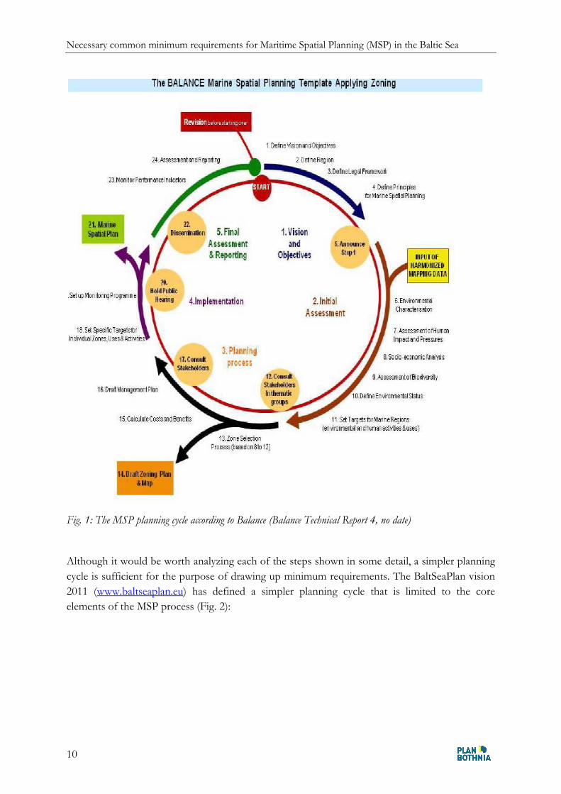
Numerous previous projects have elaborated MSP planning cycles or drawn up handbooks for
MSP, including the BaltCoast project (2005), the PlanCoast project (2008), the Balance project
(2009), or the UNESCO MSP handbook (2009). The Balance project has elaborated an all-
embracing MSP process cycle which can serve as a useful basis to show the various steps
involved (Fig. 1).
1 17 December 2010, COM (2010) 771 2 www.whitehouse.gov/administration/eop/oceans/cmsp, accessed 8 July 2011
Necessary common minimum requirements for Maritime Spatial Planning (MSP) in the Baltic Sea
10
Fig. 1: The MSP planning cycle according to Balance (Balance Technical Report 4, no date)
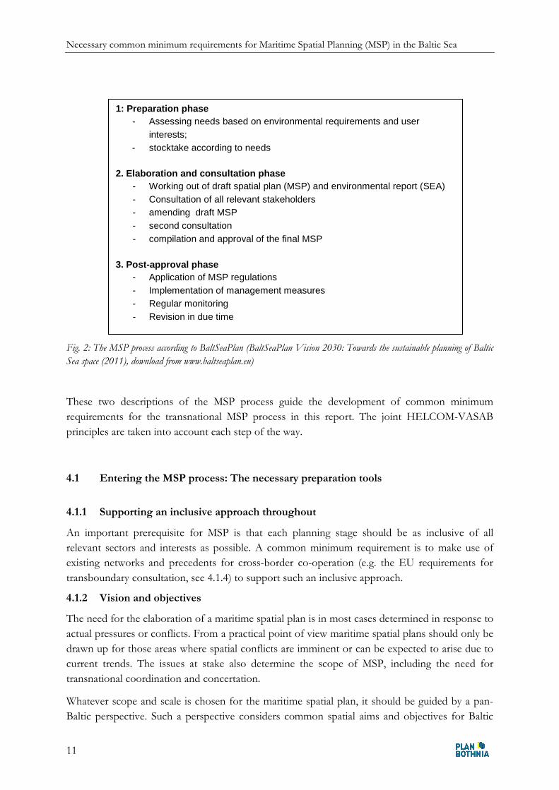
Although it would be worth analyzing each of the steps shown in some detail, a simpler planning
cycle is sufficient for the purpose of drawing up minimum requirements. The BaltSeaPlan vision
2011 (www.baltseaplan.eu) has defined a simpler planning cycle that is limited to the core
elements of the MSP process (Fig. 2):
Necessary common minimum requirements for Maritime Spatial Planning (MSP) in the Baltic Sea
11
Fig. 2: The MSP process according to BaltSeaPlan (BaltSeaPlan Vision 2030: Towards the sustainable planning of Baltic
Sea space (2011), download from www.baltseaplan.eu)
These two descriptions of the MSP process guide the development of common minimum
requirements for the transnational MSP process in this report. The joint HELCOM-VASAB
principles are taken into account each step of the way.
4.1 Entering the MSP process: The necessary preparation tools
4.1.1 Supporting an inclusive approach throughout
An important prerequisite for MSP is that each planning stage should be as inclusive of all
relevant sectors and interests as possible. A common minimum requirement is to make use of
existing networks and precedents for cross-border co-operation (e.g. the EU requirements for
transboundary consultation, see 4.1.4) to support such an inclusive approach.
4.1.2 Vision and objectives
The need for the elaboration of a maritime spatial plan is in most cases determined in response to
actual pressures or conflicts. From a practical point of view maritime spatial plans should only be
drawn up for those areas where spatial conflicts are imminent or can be expected to arise due to
current trends. The issues at stake also determine the scope of MSP, including the need for
transnational coordination and concertation.
Whatever scope and scale is chosen for the maritime spatial plan, it should be guided by a pan-
Baltic perspective. Such a perspective considers common spatial aims and objectives for Baltic
1: Preparation phase - Assessing needs based on environmental requirements and user
interests; - stocktake according to needs
2. Elaboration and consultation phase
- Working out of draft spatial plan (MSP) and environmental report (SEA) - Consultation of all relevant stakeholders - amending draft MSP - second consultation - compilation and approval of the final MSP
3. Post-approval phase
- Application of MSP regulations - Implementation of management measures - Regular monitoring - Revision in due time
Necessary common minimum requirements for Maritime Spatial Planning (MSP) in the Baltic Sea
12
Sea space as a whole, acknowledging in particular the issues that need to be tackled at a pan-Baltic
level.
An area-specific vision is clearly the desirable option at this stage. The advantage of a fully
developed vision is that it concerns long-term spatial needs and solutions, giving Baltic Sea
countries the opportunity to actively set the agenda rather than just responding to external
developments. A vision would implement HELCOM-VASAB MSP principle no. 3, which states
that MSP should have a long term perspective in relation to the goals it seeks to attain and the
environmental, social, economic and territorial effects it has. It also states that MSP should be
based on long term visions, strategies and action plans. If, on the other hand, a set of common
principles has been identified upon which a maritime spatial plan for a certain part of the Baltic
Sea is based (see chapter 3), it is not a minimum requirement to develop these into a specific
vision for this part of the Baltic Sea.
With or without a common vision, clearly defined objectives are a must for any maritime spatial
plan and successful MSP process. These objectives need to define the planning area, the issues to
be resolved, responsibilities, the regulations needed and the management tools available including
finances. In doing so, they need to take into account the transnationally agreed principles for
MSP and reflect existing national commitments.
4.1.3 General information needs for the preparatory stocktake
The preparatory phase of transnational MSP calls for detailed general information on the
following topics:
� the physical and environmental characteristics of the sea area in question and wider sea
environment,
� the human uses of that area (drivers and pressures, activities in the sea and on land),
� the socio-economic situation on land (demography, economy etc)
� the relevant policy and legal background affecting the sea and sea space.
The objective should be to draw a comprehensive picture of the sea area in question. This should
first set out the major characteristics of sea space, the key sensitivities and values of the marine
environment, which is a prerequisite for implementing HELCOM-VASAB MSP principles no. 2
(the ecosystem approach) and 9, which states that MSP should acknowledge the characteristics
and special conditions of the different sub-basins of the Baltic Sea and their catchments.
Ecological analysis should be accompanied by analysis of the current and expected pressures
affecting sea space (possibly using scenarios as an aid). It should also take a look at what creates
these pressures or is likely to do so in the future (e.g. trends and developments in key sectors,
political priorities, economic and demographic developments). Last not least, it is important to set
out the existing qualitative or quantitative targets for the most important topic areas, such as
energy targets. The EU and HELCOM have defined a series of environmental targets such as
water quality targets which need to be taken into account.
It is evident that the better the knowledge of the marine environment and planning area in
question, the better the planning process can be carried out and the better the balance that can be
Necessary common minimum requirements for Maritime Spatial Planning (MSP) in the Baltic Sea
13
struck between the different interests. This means that every MSP process effectively begins with
a dilemma. On the one hand, the marine environment is often little known, research is complex
and expensive, and the available data has not always been translated into spatially relevant
information. On the other hand, the political decision to draft a maritime spatial plan is usually
driven by the need or desire to resolve a set of spatial conflicts within a given timeframe, which
limits the possibility of engaging in extensive research. Availability of spatial information is thus a
major difference between MSP and spatial planning on land: On land, spatial information is
usually better and more readily accessible. Despite this, it is crucial to strike the right balance here
between decision-making in due time and improving the information base available. The MSP
process can be used to fill information gaps and to then develop the plan accordingly.
In terms of the MSP process, the responsibility for collating this information should be clearly
assigned. The resulting preparatory stocktake should be agreed by all partners involved. A good
example of a stocktaking report at the transnational level is the Plan Bothnia assessment.
4.1.4 Topics with transnational relevance in maritime spatial plans
For the preparatory exchange of information between countries, topics then need to be identified
that are of transnational or cross-border significance, which include:
� nature conservation,
� fisheries,
� shipping including fairways
� cables and pipelines,
� offshore wind farming,
� sand and gravel extraction,
� oil and gas extraction,
� military use
� protection of underwater cultural heritage
� recreational activities
The necessary information on these topics (e.g. current status, intensity and speed of expected
developments, likely spatial needs, environmental impact etc.) is likely to be patchy. A minimum
requirement is to pull together whatever is available, noting any gaps for future research. A
conflict matrix for these topics should then be drawn up for the specific planning area and scale
in question. This should then be translated into stocktake maps that show where the main areas
of conflict lie and where competing spatial claims meet (including conflicts with important
environmental parameters).
Mapping data harmonized between all Baltic Sea countries on the topics listed here would be a
key common requirement for compatible maritime spatial plans of high quality, which would
effectively mean full implementation of the EU INSPIRE Directive. At present, this ideal
solution seems unrealistic but it does deserve further attention. It is therefore suggested as
common minimum requirement that each Baltic Sea country draws up an inventory of all their
available mapping data. This would be exchanged among all Baltic Sea countries and updated on
a regular basis. To facilitate cross border co-operation a common legend (common symbols and
Necessary common minimum requirements for Maritime Spatial Planning (MSP) in the Baltic Sea
14
colors) of the most important topics with transnational or cross border significance should be
elaborated.
4.1.5 Transnational co-operation in the preparatory phase
In summary, in the preparation phase (assessing the needs for MSP based on environmental
requirements and user interests, as well as stocktaking according to needs) the following
transnational and cross-border co-operation needs can be identified:
� information on planning intentions with possible cross border effects
� information exchange on cross border user interests
� information exchange on cross border environmental requirements
� exchange of available relevant data on the ecosystem, uses and projects.
Concerning the information exchange, EU regulations (SEA Directive) exist that have to be
applied properly and in good time. Therefore no additional procedural minimum requirements
are necessary except the ones mentioned above.
4.2 The planning and consultation phase
VASAB 2010 (Tallin 1994, see www.vasab.org), the first land-oriented common spatial planning
concept for the BSR, divided mapped content into the following three categories: pearls, strings
and patches. A spatial plan for the sea applies these same categories. However, they each carry
different weight. The BaltSeaPlan vision puts “linear elements … at the heart of transnational
MSP thinking in that they truly connect the Baltic Sea states across national borders.
Infrastructure such as cables and pipelines represent obvious linear elements, as do shipping lanes
which are not hard infrastructure. Blue corridors for living species also count as linear elements:
These are instrumental in ensuring connectivity between habitats, making sure that nursery areas,
feeding areas or spawning grounds are linked to one another.”
4.2.1 Minimum requirements for the designation of sea areas (zoning)
As explained in 3.1.b the maritime spatial plan regulates human uses in the sea in order to achieve
sustainable marine development and to contribute to environmental goals, such as protecting
marine ecosystems. Most of its regulations do not apply to the entire sea but have to be area-
specific. All areas that need the same type of regulation can be grouped as one type of designated
areas (also called zones).
Necessary common minimum requirements for Maritime Spatial Planning (MSP) in the Baltic Sea
15
In order to draft a maritime spatial plan a set of common types of zones is therefore required
with clear definitions of their legal implications (see below). This is a must because once it is
approved, the statutory maritime spatial plan is binding, at least for the public authorities that
grant permits for sea uses. The BALANCE project recommends the following 4 zones:
a) The General Use Zone
The General Use Zone is by far the largest of the four zones, and it covers all marine areas not
covered by the other three zones. It is the least restrictive of all the zones, where most human
activities are allowed.
b) The Targeted Management Zone
The Targeted Management Zone is applied for areas where the use is restricted further, where an
authorisation (permit, licence) has been granted for one or several activities or where the area
includes nature conservation targets that require that the use of the area to be regulated, either
permanently or temporarily.
c) The Exclusive Use Zone
The Exclusive Use Zone shows the extent (cover) of the marine area reserved exclusively for a
single use, which prevents the sea area to be used by most other types of sea use. Examples of
exclusive sea use in this zone are, e.g. wind energy parks, harbours, aquaculture (fish farms, mussel
farms), marine aggregate extraction sites or areas set aside for nature protection e.g. vulnerable
Habitat Directive Annex 1 habitats or nationally important areas for bird protection (often
identified by several protection measures such as the Birds Directive, IBA, Ramsar, HELCOM or
national programmes).
d) The Restricted Access Zone
The restricted access zone is, as the name implies, the zone subject to the most rigorous
regulations. The purpose is similar to the Exclusive Use Zone but the main difference is the very
strict restricted access (BALANCE Interim Report No. 40, p.48 – 50).
The BaltSeaPlan vision report also suggests 4 types of zones (there called areas):
a) Priority areas, where no use is allowed that would significantly constrain the use that is
given priority in this area. Strict priority areas could be shipping lanes, nature protection
Zones or areas?
There is some debate over the term of “zoning”. This report uses the term analogous to
“designated area”, understanding zoning as a spatial planning tool that allows certain activities
to be restricted or encouraged in specified designated areas. Zoning is thus a means of exerting
area-based control and of separating conflicting uses. We prefer the term zone since area is not
specific and could refer to any area of sea. Different types of zones (or designated sea areas) are
suggested as minimum requirements and described below. For a definition of zoning see the
2008 Balance report on MSP p. 8.
Necessary common minimum requirements for Maritime Spatial Planning (MSP) in the Baltic Sea
16
areas, offshore wind farm sites, fish spawning and nursery areas, raw material resources,
marine archaeological sites, or areas important for tourism.
b) reservation areas, where a certain use is given special weight in the process of balancing
the competing interests in the area. The difference to priority areas is that it is not certain
that the use receiving specific attention has absolute priority.
c) No go areas, where certain uses (e.g. wind farms, shipping, fishing) or all uses are
prohibited.
d) Open use areas, where no uses have priority.
Both concepts are similar with respect to the following three zones:
� General use zone – open use area,
� Exclusive use zone – priority area,
� Restricted access zone – no go area.
As a minimum requirement, the proposal is to limit zoning to these 3 basic zones using the
following terms and definitions:
� General use zone, where no use is given priority or restricted by the rules of the spatial
plan. This is a “white” area where no specific additional zoning is necessary. Naturally,
any uses are still subject to the international and national legal restrictions for sea uses.
White areas such as the general use zone are an important reserve of space that can be
made available to future sea uses.
� Priority use zone, where no use is allowed that would significantly constrain the use that
is given priority in this zone. Priority use zones could be shipping lanes, nature
conservation areas, offshore wind farm sites, fish spawning and nursery areas, material
resources, marine archaeological sites, or areas important for tourism.
� Restricted access zone where certain uses are prohibited. A restricted access zone is the
opposite of a priority use zone, in that it does not give a privilege to a certain use but
prohibits it. That can apply to wind farms, shipping, fishing etc.
Two types of zones are not similar in the BALANCE report and the BaltSeaPlan vision, namely
“reservation area” and “targeted management zone”. With respect to its legal implications, the
reservation area of the BaltSeaPlan vision is an intermediate zone between the General use zone
and the Priority use zone. Whilst it is a useful option for zoning, it is not needed as a minimum
requirement.
The BALANCE Targeted Management Zone – as implied by its name - contains specific
management regulations for a specific area. This is a necessary supplement to the three basic
zones in that it represents an optional addition or overlaying zone. A targeted management zone
can thus span just one or several of the other three zones, or parts of these zones. Its main
purpose is to define detailed regulations, which can be applied to any of the three basic zones or
parts of it and can be permanent or temporary. The most prominent case for these concrete
Necessary common minimum requirements for Maritime Spatial Planning (MSP) in the Baltic Sea
17
management regulations are the Natura 2000 area management plans, see 4.3.2. Therefore we
need as an additional minimum requirement a
• Targeted Management Zone where the underlying basic zone needs to be
complemented by detailed management regulations.
Any element that does not need a designation with regulatory content can be added to the plan,
but this is for information only. The clear distinction between designated elements and elements
for information is crucial to avoid confusion in applying and implementing the plan after its
approval.
4.2.2 Minimum requirements for MSP zoning maps
The need for a common legend (common symbols and colours) for the most important topics
with transnational or cross-border significance and its role in facilitating cross-border co-
operation during the preparatory stocktake of mapped information was explained in 4.1.3. For
MSP zoning maps the need for a common legend is even more obvious because the regulations
stipulated in these maps may directly affect neighbouring countries.
The content of a MSP zoning map can be divided into two groups: designations and information
only. Designations are those areas where the maritime spatial plan imposes restrictions or gives
privileges to certain sea uses. All other items shown in the map, in particular physical objects, are
shown for information only.
A common legend defining the minimum content of any MSP zoning map is a necessary
minimum requirement to enable the transnational or cross-border co-operation in the MSP
process.
Elements contained in the common legend could comprise the following:
Shipping
Priority Use Zone Shipping:
� Clearway,
� Traffic separation system
� Anchorage area
� Roadstead
Reservation zone shipping (optional)
Nature Conservation:
Priority Use Zone Nature Conservation
� Designated Natura2000 Areas
� Natura2000 to be designated
� BSPA not included in Natura 2000
Reservation Zone Nature Protection (optional)
Necessary common minimum requirements for Maritime Spatial Planning (MSP) in the Baltic Sea
18
� Other areas of possible great ecological value
Wind energy:
� Priority Use Zone wind energy
� Reservation Zone wind energy search area (optional)
For information:
� Approved
� Under construction / Operational
Submarine linear infrastructure:
� Priority Use Zone corridor/gate for pipelines, cables
For information:
� Pipelines
� Cables
Military Area (for information only)
Extraction
� Priority Use Zone sand, gravel or aggregate extraction
� Reservation Zone sand, gravel or aggregate extraction (optional)
Platforms (for information only)
A common standardized graphic design has to be attributed to these elements of the MSP zoning
map.
4.2.3 The issue of common scales
A sometimes controversial question is whether the scales of MSP zoning maps should be
standardized. There is an obvious need to standardize scales in the case of pan-Baltic sea maps;
such maps, however, will primarily be analytical and/or informative maps rather than actual
zoning maps. For transnational information-bearing maps, a joint scale should be agreed as a
necessary minimum requirement.
The need for a common scale is also obvious for cross-border maritime spatial plans. The scale
chosen, however, may differ depending on the size of the plan area (e.g. the Pomeranian Bight
pilot case of the BaltSeaPlan project, where four countries (SE, DK, PL, DE) co-operate, needs a
different scale for their cross-border maritime spatial plan than the Curonian Lagoon area, where
a bilateral co-operation of Russia and Lithuania would be adequate). It therefore makes no sense
to fix one scale for all cross-border maritime spatial plans. The suitable scale should be agreed by
the parties involved on a case by case basis.
Necessary common minimum requirements for Maritime Spatial Planning (MSP) in the Baltic Sea
19
4.2.4 Transnational information and co-operation needs during plan elaboration
National spatial plans and programmes might affect the spatial development of the seas of
neighbouring countries. Their development therefore needs cross-border co-ordination even
though they exclusively cover national areas (HELCOM-VASAB MSP principle no.7, which
states that whenever possible, maritime spatial plans should be developed and amended with the
Baltic Sea Region perspective in mind).
For the elaboration and consultation phase the following transnational and cross border co-
operation needs can be identified:
� Co-ordination/reconciliation of planned designations of areas/regulations with possible
transnational or cross border effects.
� Elaboration of a joint (transnational) plan where necessary (e.g. for cross border linear
infrastructure, although this may be better decided on a case by case basis)
For the consultation process EU regulations exist concerning public participation linked to the
strategic environmental assessment (SEA). These are binding to all Baltic Sea countries except
Russia and would need to be negotiated with Russia to cover the whole Baltic Sea.
The socio-economic analysis in the consultation process is not regulated by the EU. A useful
additional minimum requirement might be to make it compulsory to include the socio-economic
analysis in the consultation process, even though this may be obvious (minimum requirement).
4.3 Minimum requirements in the post-approval phase
The main activities in this last part of the planning cycle are the following:
� Application of MSP regulations
� Implementation of management measures
� Regular monitoring
� Revision in due time.
The question is what kind of requirements will be needed to ensure effective transnational co-
operation in these four fields of activity.
4.3.1 Application of MSP regulations
A main purpose of the maritime spatial plan is to grant or deny permits to private or public sea
uses based on the regulations set out in the plan (e.g. for a cable, a wind farm, dredging). If the
proposed sea use has potential transnational or cross-border implications, consultation with the
countries concerned is a minimum requirement.
In addition for most large scale planned investments a project related EIA is compulsory
according to EU law. This analysis should be extended to all relevant social and economic aspects
of the project in the form of a Territorial Impact Assessment (TIA), as proposed by the
BaltSeaPlan vision report.
Necessary common minimum requirements for Maritime Spatial Planning (MSP) in the Baltic Sea
20
4.3.2 Implementation of management measures
Maritime spatial plans need to be complemented by a variety of management measures. For
Natura 2000 areas, EU regulations stipulate a management plan which sets out concrete
management measures related to the specific protection objectives of the area.
Management plans accompanying the different zones specified in the maritime spatial plan need
to be implemented, meaning enforcement of the (temporary) rules that apply. Depending on the
type of zone (and on the management objective) these rules may be strict.
A different form of management is called for in case of specific projects that might have been
foreseen in a maritime spatial plan (e.g. cables for a Baltic Sea Supergrid). Although the
implementation of such a structure is in the hands of the private or public investor, it is subject to
supervision according to the regulations of the plan (see 4.3.1). If that structure has transnational
or cross-border implications specific agreement is required among the countries concerned, not
least with respect to the precautionary principle set out in HELCOM-VASAB MSP principle no.
4.
4.3.3 Monitoring, evaluation and revision
“The processes of monitoring, evaluation, and reporting are fundamental components of
effective spatial management as they provide insight into the effectiveness of the plan and
facilitate adaptive management. Monitoring is essential to assess the state of ecosystems and the
services they provide, the impact of human disturbances, and responses to restoration efforts.”
(Nordic Forum on MPAs in Marine Spatial Planning, 2009). Monitoring, however, should not be
restricted to the natural environment, but also include the socio-economic environment, with
particular focus on existing marine uses and the trends that drive developments in sea use.
Monitoring and evaluation should also include MSP process itself to establish how effective it is
in responding to the issues at hand. Due to the complexity of the marine socio-ecological system
in question, monitoring is a difficult issue, and performance indicators need to be carefully
selected. Prior agreement is necessary on what is to be evaluated. This particularly applies to any
indicators describing the quality of the MSP process itself.
Monitoring and evaluation must be done on a regular basis. In order to benefit MSP, monitoring
results need to be translated into spatially relevant information. The indicators used should be
appropriate, which means they need to have bearing on space and relate to the objectives set out
in the spatial plan. Ideally, they should also be cost-effective (HELCOM-VASAB MSP principle
no. 6, a high quality data and information base). The results should be reported in a manner that
is understandable and usable to all parties involved.
In defining common minimum requirements, we are confronted with the same problem as in the
stocktaking phase (see 4.1.2, 4.1.3). Harmonized performance indicators between all Baltic Sea
countries on all topics relevant to the objectives of the MSP would clearly be desirable, but such
detailed agreement seems unrealistic. Therefore the same common minimum requirement is
suggested as in the stocktaking phase with respect to mapped information: Each Baltic Sea
country draws up an inventory of all their available data that are needed to define the appropriate
Necessary common minimum requirements for Maritime Spatial Planning (MSP) in the Baltic Sea
21
indicators. This inventory would be updated on a regular basis and exchanged among all Baltic
Sea countries.
Furthermore a common timetable should be agreed for updating and revision of the maritime
spatial plan (minimum requirement). The BALANCE project suggests 6 years as an appropriate
time span for revision. This would implement HELCOM-VASAB MSP principle no. 10, which
emphasizes that MSP is a continuous process.
5. Minimum requirements III: Legal provisions and institutions
To identify legal minimum requirements for MSP we first need to take a look at the existing legal
framework on the international pan Baltic and national level. In what way does this framework
restrict or encourage MSP?
5.1 International law and EU regulations
The sources of the Law of the Sea include customary international law as well as a range of
conventions, treaties and agreements, the most important of which is the 1982 United Nations
Convention on the Law of the Sea (UNCLOS). Other worldwide rules with relevance to MSP
include the regulations of the International Maritime Organisation (IMO), which is responsible
for traffic separation schemes, and the International Convention for the Prevention of Pollution
from Ships (MARPOL) which defines special areas where mandatory methods for pollution
control are required.
A recent EU report concludes that the EU-Member States encounter relatively few constraints
under international or EU law with regard to MSP in their internal waters and territorial seas as
long as the innocent passage of foreign vessels is respected. MSP may involve the prohibition of
fishing as well as the regulation of navigation subject to consultation with IMO. Consultation
with neighbouring states will also be necessary in cases where plans or projects may result in
significant adverse environmental impacts across borders.
According to the EU, MSP may be undertaken within the EEZ with regard to most marine-
related activities including the exploration, exploitation, conservation and management of living
and non-living natural resources. Constraints on MSP derive from the freedom of navigation as
well as the laying of submarine cables and pipelines (Legal aspects of MSP, summary report, EU
2009).
The recent EU documents related to Maritime Policy explicitly encourage MSP by the Member
States. The Natura 2000 Directives, the Water Framework Directive as well as the SEA, EIA and
their cross-border consultation requirements established under EU law have implications as to
how MSP should be undertaken in the Baltic Sea. However, they do not apply to Russia.
HELCOM and VASAB as pan-Baltic bodies endorse MSP and give guidelines as to how it
should be conducted (see chapter 3).
Looking at the legal framework available in the Baltic Sea states, the current picture is
heterogeneous. Not all countries have established a legal basis for MSP as yet.
Necessary common minimum requirements for Maritime Spatial Planning (MSP) in the Baltic Sea
22
The above leads to two conclusions for common legal minimum requirements:
� The existing international legal framework, especially UNCLOS, is a precondition which
needs to be taken into account when conducting MSP.
� It is imperative that all Baltic Sea countries possess a national legal basis for MSP.
5.2 Minimum requirements for the legal framework in the Baltic Sea states
National law on MSP should have the following minimum content:
� Designation of the responsible authority:
o for MSP in the EEZ,
o for MSP in territorial waters,
o for ICZM.
� Specification of the issues to be regulated in the plan,
� the legal effect of the plan (whether the law is binding to public authorities only or to
private persons too)
� basic requirements for the participation process,
� requirements for transnational and cross-border co-operation beyond the existing
international and EU regulations
� Monitoring requirements
� The maximum period for updating and revision of the plan.
5.3 Requirements for transnational institutions
The EU Baltic Sea Strategy 2009 recommends no new institutions. “The Baltic Sea Region has
many cooperative structures: we should not create new ones that could impose added
administrative overhead without contributing to effective action”3.
Nevertheless, to achieve a pan-Baltic agreement on minimum requirements for MSP, a formal
ministerial coordinating body for pan-Baltic MSP issues is needed (formed by the national
Ministers responsible for spatial planning). As a minimum requirement, this body has to agree on
the common principles to be applied and to approve the jointly agreed methods and contents for
maritime spatial plans. This ministerial coordinating body could be linked to the Council of Baltic
Sea States (CBSS). CBSS should ensure that agreed pan-Baltic MSP strategies are incorporated
into the overall BSR development concepts as well as in the EU-Northern Dimension policy.
3 COMMUNICATION FROM THE COMMISSION TO THE EUROPEAN PARLIAMENT, THE COUNCIL, THE EUROPEAN ECONOMIC AND SOCIAL COMMITTEE AND THE COMMITTEE OF THE REGIONS concerning the European Union Strategy for the Baltic Sea Region , Brussels, 10.6.2009
Necessary common minimum requirements for Maritime Spatial Planning (MSP) in the Baltic Sea
23
Common methods and contents need to be prepared by a transnational coordinating body at the
technical level, which is another minimum requirement. This transnational coordinating body
should bring together representatives from the national planning authorities plus other relevant
institutions and stakeholders (including Russia) and the sectoral national agencies concerned. It is
important that this body represents all relevant stakeholders as this ensures implementation of
HELCOM-VASAB MSP principle no. 6 on participation and transparency for the transnational
level, as well as principle no. 8 on coherence between terrestrial and maritime spatial planning.
Both bodies need to be accountable and work in a transparent manner.
Importantly, this does not mean new institutions. HELCOM and VASAB have formed a
common working group for MSP that could be further developed and strengthened to fulfill the
requirements of the coordinating body at the technical level mentioned above. The ministers of
both, HELCOM and VASAB, could form a corresponding decision making body whose task it is
to approve the proposals of the coordinating body at the technical level.
6. Learning and training requirements
6.1 A new understanding of the MSP process
The MSP process is an open one, and solutions may break with long-held “do’s and don’ts”. As
such, all those participating in this process may need to break with long-held ideas and concepts
of planning and management. Rather than dismiss contradictory perspectives of the world, the
MSP process incorporates multiple viewpoints into the same problem-solving process, focusing
on quality of information and subjective value judgements as much as on hard scientific fact.
An important requirement is to understand MSP as a constant process of learning that requires
learning institutions. Learning at the content level means regular assessment of the national and
international policy context in which the common spatial vision is placed, and to take note of the
results of socio-economic and ecological monitoring when drawing up new MSP content.
Learning at the process level means applying indicators for progress in MSP in line with EU
requirements. The MSP process should be subject to regular monitoring just as much as marine
space itself, to make sure the process yields the intended results (such as participation and
transparency). Process targets should be drawn up and agreed for transboundary MSP processes.
The MSP process relies on informed stakeholders. Mechanisms need to be implemented to
ensure the regular involvement of the necessary stakeholders at the transboundary level.
There is a need to train and inform politicians of the need and benefits of transnational MSP,
such as the economic benefits it can yield.
Planners themselves also need training in the specifics of maritime spatial planning and how this
is different from land-based spatial planning.
Necessary common minimum requirements for Maritime Spatial Planning (MSP) in the Baltic Sea
24
7. Summary of common minimum requirements
This report sets out minimum requirements for transnational maritime spatial planning through
successful co-operation between countries around the Baltic Sea. It is based on the relevant
international and EU regulations as well as the joint HELCOM-VASAB Baltic Sea Broad Scale
Maritime Spatial Planning Principles, which are used as a yardstick to the recommendations. As
the study focuses on transnational co-operation the proposals are limited to those items that
should be included in agreements between the Baltic Sea states to facilitate successful co-
operation across national borders. “Minimum requirements” are not understood as minimum
standards for MSP, but a minimum “package” of elements that need to be brought together.
7.1 Minimum requirements for the legal framework in the Baltic Sea states
All Baltic Sea countries require national legislation on MSP. This should have the following
minimum content:
� Designation of the responsible authority:
o for MSP in the EEZ,
o for MSP in territorial waters,
o for ICZM.
� Specification of the issues to be regulated in the plan,
� the legal effect of the plan (whether the law is binding to public authorities only or to
private persons too)
� basic requirements for the participation process beyond the EU regulations for SEA
requirements for transnational and cross-border co-operation beyond the existing
international and EU regulations
� Monitoring requirements
� The maximum period for updating and revision of the plan.
7.2 Minimum requirements for transnational institutions
� To achieve a pan-Baltic agreement on minimum requirements for MSP, a formal
ministerial coordinating body for pan-Baltic MSP issues is needed. This body has to agree
on the common principles to be applied and to approve the jointly agreed methods and
contents for maritime spatial plans.
� Common methods and contents including an integrated vision for the Baltic Sea as a
whole need to be prepared by a transnational coordinating body at the technical level.
This does not mean new institutions. HELCOM and VASAB have formed a common working
group for MSP that could be further developed and strengthened to fulfill the requirements of
the coordinating body at the technical level mentioned above. The ministers of both, HELCOM
Necessary common minimum requirements for Maritime Spatial Planning (MSP) in the Baltic Sea
25
and VASAB, could form a corresponding decision making body, that has to approve the
proposals of the coordinating body at the technical level.
7.3 Minimum requirements for plan preparation
� Clearly defined objectives are a must for any maritime spatial plan and successful
transnational MSP process. These objectives need to define the planning area, the issues
to be resolved, responsibilities, the regulations needed and the management tools
available including finances.
� Transnational and cross-border co-operation requirements in the preparatory phase
(assessing the needs for MSP based on environmental requirements and user interests, as
well as stocktaking according to needs) are the following:
o information on planning intentions with possible cross border effects
o information exchange on cross border user interests
o information exchange on cross border environmental requirements
o exchange of available relevant data on the ecosystem, uses and projects
� an agreement on general information needs for the preparatory stocktake has to include:
o the physical and environmental characteristics of the sea area in question and
wider sea environment,
o the human uses of that area (drivers and pressures, activities in the sea and on
land),
o the socio-economic situation on land (demography, economy etc)
o the relevant policy and legal background affecting the sea and sea space.
� The agreement on the main topics with transnational relevance in maritime spatial plans
should include the following items:
o nature conservation,
o fisheries,
o shipping including fairways
o cables and pipelines,
o offshore wind farming,
o sand and gravel extraction,
o oil and gas extraction,
o military use
o archaeology and cultural heritage
o recreational activities.
� Mapping data harmonized between all Baltic Sea countries would be a key common
requirement for compatible maritime spatial plans of high quality.
Necessary common minimum requirements for Maritime Spatial Planning (MSP) in the Baltic Sea
26
� At present, this ideal solution seems unrealistic. It is therefore suggested as common
minimum requirement that each Baltic Sea country draws up an inventory of all their
available mapping data.
� To facilitate the cross border co-operation a common legend (common symbols and
colors) of the most important topics with transnational or cross border significance has to
be elaborated.
7.4 Minimum requirements for the planning and consultation phase
The designation of areas, where the maritime spatial plan imposes restrictions or gives privileges
to certain sea uses, is the core of any maritime spatial plan. A full set of possible designated areas
(here called zones) is not needed as a common minimum requirement, but an agreement on at
least the following 3 basic types of zones should be reached to facilitate the transnational co-
operation:
� General use zone, where no use is given priority or restricted by the rules of the spatial
plan. This is a “white” area where no specific additional zoning is necessary. Naturally,
any uses are still subject to the international and national legal restrictions for sea uses.
� Priority use zone, where no use is allowed that would significantly constrain the use that
is given priority in this zone. Priority use zones could be shipping lanes, nature
conservation areas, offshore wind farm sites, fish spawning and nursery areas, material
resources, marine archaeological sites, or areas important for tourism.
� Restricted access zone where certain uses are prohibited. A restricted access zone is the
opposite of a priority use zone, in that it does not give a privilege to a certain use but
prohibits it. That can apply to wind farms, shipping, fishing etc.
In addition there is a need for an additional type of zone as a minimum requirement:
� Targeted Management Zone where the underlying basic zone needs to be
complemented by detailed management regulations.
The main purpose of the Targeted Management Zone is to define detailed regulations, which can
be applied to any of the 3 basic zones as an overlaying designation. Its regulations can be
permanent or temporary and it can cover a whole basic zone or parts of it only. The most
prominent case for these concrete management regulations are the Natura 2000 area management
plans, see 4.3.2.
Transnational co-operation during plan elaboration in form of information and concertation is
needed for planned designations of areas/regulations with possible transnational or cross border
effects. The joint elaboration of a transnational plan or parts of it is needed, where information
and concertation is not sufficient (e.g. for cross border linear infrastructure).
Necessary common minimum requirements for Maritime Spatial Planning (MSP) in the Baltic Sea
27
7.5 Minimum requirements for the post-approval phase
� A main purpose of the maritime spatial plan is to grant or deny permits to private or
public sea uses based on the regulations set out in the plan (e.g. for a cable, a wind farm,
dredging). If the proposed sea use has potential transnational or cross-border
implications, consultation with the countries concerned is a minimum requirement.
� Monitoring: If a maritime spatial plan contains infrastructure projects with transnational
or cross-border implications the management of such a project requires a specific
agreement among the countries concerned. Harmonized performance indicators between
all Baltic Sea countries on all topics relevant to the objectives of the MSP are desirable,
but such detailed agreement seems unrealistic.
� Minimum requirement: Each Baltic Sea country draws up an inventory of all their
available data that are needed to define the appropriate indicators.This inventory would
be updated on a regular basis and exchanged among all Baltic Sea countries.
� Consultation with the countries concerned is needed for updating and revision of the plan
using the same standards as for plan elaboration.
Necessary common minimum requirements for Maritime Spatial Planning (MSP) in the Baltic Sea
28
Literature
BALANCE Technical Summary Report, part 4: Towards marine spatial planning in the Baltic
Sea. BALANCE Lead Partner: The Danish Forest and Nature Agency, Haraldsgade 53,
DK-2100 Copenhagen Ø, Denmark, no date.
Cieslak, Andrzej et al. (2009): Compendium on Maritime Spatial Planning Systems in the Baltic
Sea Region Countries, Warsaw-Gdansk.
Douvere, F. (2008). The importance of marine spatial planning in advancing ecosystem-based sea
use management. Marine Policy, 32(5), 762-771.
Ehler, C. & Douvere, J. (2009): Marine Spatial Planning: a step-by-step approach toward
ecosystem-based management. Intergovernmental Oceanographic Commission and Man
and the Biosphere Programme. Manual and Guides No. 53, IOCAM Dossier No. 6. Paris:
UNESCO.
European Communities (2009): Legal aspects of MSP. Summary report, Luxembourg: Office for
Official Publications of the European Communities, ISBN 978-92-79-12064-0
Gee, K., Kannen, A., Heinrichs, B. (2011): BaltSeaPlan Vision 2030: Towards the sustainable
planning of Baltic Sea space, download from www.baltseaplan.eu
HELCOM Baltic Sea Action Plan adopted at the HELCOM Ministerial Meeting on 15
November 2007 in Krakow, Poland
Kommittédirektiv Havsplanering i svenska vatten Dir. (2009): Managing the Marine Mosaic: A
Briefing on Marine Spatial Planning with an Ecosystem Approach. In: 109 Beslut vid
regeringssammanträde den 19 november 2009, Executive Summary, pp. 496-472.
Nordic Council of Ministers (2009): Marine Spatial Planning in the Nordic region – Principles,
Perspectives and Opportunities. Outcomes from the Nordic Forum on MPAs in Marine
Spatial Planning. Copenhagen, 95 pp.
Schultz-Zehden, A., Gee, K., Scibior, K. (2008): Handbook on Integrated Maritime Spatial
Planning: Experience, Tools & Instruments, Case Studies from the INTERREG III B
CADSES PlanCoast Project. Berlin, 98 pp.