Embed Size (px)
Citation preview

NDBC Web Data Guide
NDBC Web Data Guide
National Data Buoy Center (NDBC)
Stennis Space Center, Mississippi 39529-6000
October 2015
NDBC Web Data Guide
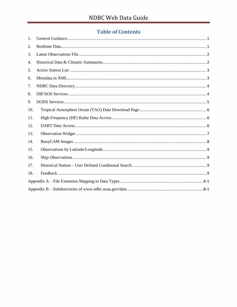
Table of Contents 1. General Guidance .................................................................................................................................. 1
2. Realtime Data ........................................................................................................................................ 1
3. Latest Observations File........................................................................................................................ 2
4. Historical Data & Climatic Summaries................................................................................................. 2
5. Active Station List ................................................................................................................................ 3
6. Metadata in XML .................................................................................................................................. 3
7. NDBC Data Directory ........................................................................................................................... 4
8. DIF/SOS Services ................................................................................................................................. 4
9. DODS Services ..................................................................................................................................... 5
10. Tropical Atmosphere Ocean (TAO) Data Download Page ............................................................... 6
11. High Frequency (HF) Radar Data Access ......................................................................................... 6
12. DART Data Access ........................................................................................................................... 6
13. Observation Widget .......................................................................................................................... 7
14. BuoyCAM Images ............................................................................................................................ 8
15. Observations by Latitude/Longitude ................................................................................................. 9
16. Ship Observations ............................................................................................................................. 9
17. Historical Station – User Defined Conditional Search ..................................................................... 9
18. Feedback ........................................................................................................................................... 9
Appendix A – File Extension Mapping to Data Types ............................................................................. A-1
Appendix B – Subdirectories of www.ndbc.noaa.gov/data ....................................................................... B-1

NDBC Web Data Guide
Version 1.0 1
1. General Guidance
This document provides a high level over view of data available on the NDBC web site
(http://www.ndbc.noaa.gov/) to support data consumers. The goal is to assist the user in
determining the best option for obtaining their required data while minimizing the potential
load on the NDBC web farm. We recommend that you review the entire content of this
document prior to deciding on your implementation strategy, because NDBC supports
numerous methods to obtain data from our web site. We highly discourage you from
developing unique processes (i.e. screen scrape mobile page) to obtain our data via other
methods since future development may have a negative impact on your process. We also ask
that you consider the frequency of the data updates and limit your data request to conserve
our bandwidth and ability to support other users. If after reviewing this document you still
have concerns in regards to the best method please contact us via the web master e-mail
[email protected] and we can provide additional guidance.
NDBC currently has FTP services that are available; however, our future plans are to
discontinue these services, therefore, we will not address them in this document. We
strongly recommend that you avoid the use of FTP services when using the NDBC web site.
The majority of data posted to the NDBC web server are stored in ascii files that may be
downloaded via HTTP, wget, or Perl/LWP (among other utilities). HTTP is the preferred
protocol.
2. Realtime Data
The Realtime directory http://www.ndbc.noaa.gov/data/realtime2/ contains the current (last
45 days) data. The term Realtime refers to the version of the data. In general, Realtime data
are the data that have undergone automated quality control checks as they were received in
real time and released on the Global Telecommunications System (GTS). The files are named
station_id.datatype.
See appendix A for a listing of the data type extensions and the associated data.
As an example, the following files would apply to station 41002,
the standard meteorological data is in 41002.txt
the continuous winds data is in 41002.cwind
the spectral wave summary data is in 41002.spec
the raw spectral wave data is in 41002.data_spec
etc.

NDBC Web Data Guide
Version 1.0 2
In building file names all alphabetic characters must be in upper case. For instance the C-
MAN (land) station FPSN7 – Frying Pan Shoals, NC must be entered in uppercase, e.g.,
FPSN7.txt.
Not all of these data types are available for each station; however, each station has at least
one data type.
See Measurement Descriptions and Units for more information on the units of measure used
on the NDBC web site. Samples of each file type are available at the following URL:
http://www.ndbc.noaa.gov/mods.shtml
You can also navigate to this data by selecting a station page and then scrolling down to the
bottom and selecting the “Real Time Data” link.
3. Latest Observations File
The latest observation file is available at:
http://www.ndbc.noaa.gov/data/latest_obs/latest_obs.txt
This file contains essentially the same data elements as the standard meteorological data file,
however, instead of having the observations from a single station; this file has the most
recent observation (provided that the observation is less than two hours old) from all stations
hosted on the NDBC web site. Since this file has multiple stations it also contains the
position information (latitude and longitude) for each station. The file is relatively small, less
than 100KB, and is updated approximately every 5 minutes, so it would be a good source of
data if you are interested in meteorological observations from multiple stations.
4. Historical Data & Climatic Summaries
The historical files are available at:
http://www.ndbc.noaa.gov/station_history.php?station=42040
Where the 42040 represents the station that you are interested in.
You can also navigate to this page by selecting a station page and then scrolling down to the
bottom and selecting the “Historical Data & Climatic Summaries” link.
The returned page will have four main sections:
Quality Controlled data for the current year – by months
Historical Data – by calendar year

NDBC Web Data Guide
Version 1.0 3
Search historical meteorological data for observations that meet your threshold
conditions
Climatic summary table and plots – by parameter. For details about this information
please review the description available at:
http://www.ndbc.noaa.gov/climatedesc.shtml
5. Active Station List
The Active Station List is available at http://www.ndbc.noaa.gov/activestations.xml
This file provides metadata in regards to the current deployment for all active stations on
the NDBC web site. The metadata includes station ID, latitude, longitude, station name,
station owner, program to which the station belongs, and type of data reported as detailed
below:
met: indicates whether the station has reported meteorological data in the past eight
hours (y/n).
currents: indicates whether the station has reported water current data in the past
eight hours (y/n).
waterquality: indicates whether the station has reported ocean chemistry data in the
past eight hours (y/n).
dart: indicates whether the station has reported water column height/tsunami data in
the past 24 hours (y/n).
This file is refreshed every five minutes as needed. Note: The main activity that drives
changes are: a service visit, establishment of a new station, or changes in the type of data
received (i.e. sensor/station failure) therefore, minimal updates would be expected in a 24
hour period.
Note, the TAO entries do not include the data type attributes (met, currents, water quality and
dart) but do include a seq attribute for syncing access to the TAO web site. The TAO array is
the climate stations in the equatorial Pacific.
6. Metadata in XML
The metadata in XML is available at:
http://www.ndbc.noaa.gov/metadata/stationmetadata.xml
The supporting XML schema can be found at:
http://www.ndbc.noaa.gov/metadata/stationmetadata.xsd
NDBC Web Data Guide
Version 1.0 4
This file contains the historical metadata back to 2000 for all stations on the NDBC
website. Limited metadata is available for non-NDBC stations. The file is generated once
daily at midnight U.S. Central Time (05:00 UTC during daylight saving time or 06:00 UTC
during standard time).
Note: this file is fairly new and there were some inconsistencies in our older metadata, so this
file is not 100% accurate, however, it is the best representation of the station history from our
perspective.
7. NDBC Data Directory
The most important files from this directory have already been covered in depth in previous
sections; however, this section gives you a broad overview of all the files available under the
data directory available at: http://www.ndbc.noaa.gov/data/
See Appendix B for a listing of the subdirectories under the Data directory.
8. DIF/SOS Services
The NDBC Sensor Observation Service (SOS) is an implementation of the Open Geospatial
Consortium (OGC) SOS 1.0 specification that supports the Core Operations Profile. An
overview is available at: http://sdf.ndbc.noaa.gov/sos/. An interactive demonstration is
available at: http://sdf.ndbc.noaa.gov/. The actual service is available at:
http://sdf.ndbc.noaa.gov/sos/server.php . This service provides an API for accessing
observation data for the following measurements:
Air Temperature
Conductivity
Currents
Salinity
Sea Level Pressure
Water Level
Water Temperature
Waves
Winds
These data may be returned in the following formats:
comma-separated values (CSV)
tab-separated values (TSV)
KML/JSON (experimental)
OGC Sensor Web Enablement (SWE) 1.0 using the IOOS template
NDBC also supports a GML response, but its use is discouraged as it will be discontinued in
a future update. SOS is intended to support machine to machine interface, without human

NDBC Web Data Guide
Version 1.0 5
intervention. One of the limitations of the current NDBC implementation is that you can only
request one data type per request. However, you can make multiple calls to obtain all
observations. This lack of multiple observed properties and higher complexity queries are a
limitation to its current use. However, if you are interested in a single or limited data types
(i.e. water level/Tsunami) then SOS maybe a good fit.
9. DODS Services
The NDBC Distributed Oceanographic Data System (DODS) makes netCDF files available
to the science community and general public via our website. It uses the Open Source
Project for a Network Data Access Protocol (OPeNDAP) software for data providers to share
data with each other and the end users. This service is available at the following URL:
http://dods.ndbc.noaa.gov/
The following provides a high level overview of the directory structure/data types available
via the NDBC DODS server:
All NDBC Data
NDBC Data
adcp – Acoustic Doppler Current Profiler Data contains depth, direction and
speed
adcp2 –Acoustic Doppler Current Profiler Data with additional QC
information primarily from Gulf of Mexico oil rigs.
cwind – Continuous Winds data
dart – Deep-ocean Assessment and Reporting of Tsunamis data
eval – DO NOT USE - Unofficial data
mbcurr – Marsh-McBirney Current Measurements data
ocean – Oceanographic data
oceansites – see OceanSITES Data directory below.
pwind – Peak Winds data
stdmet – Standard Meteorological data
swden – Spectral Wave Density data with Spectral Wave Direction data
tao-adcp - see “NDBC TAO Data” directory below.
tao-ctd - see “NDBC TAO Data” directory below.
wlevel – Water Level data (tide) measured from a non-DART NDBC station
NDBC TAO Buoy Data – The subdirectories are named for each station, based on the
latitude and longitude. For example the station at equator and 110W is named
T0N110W, the station at 2N 110W is named T2N110W. The “T” in the first position
of the file name designates that it is a TAO site.
NDBC TAO CTD Data – contains the TAO CTD data collected on servicing cruises
organized by cruise id. The cruise id consist of a two letter ship id, a two digit fiscal

NDBC Web Data Guide
Version 1.0 6
year, and a sequence number for each cruise performed in support of TAO for that
year.
OceanSITES Data – provides access to OceanSITES data, including TAO. Note the
TAO data is the same data as available under the ‘NDBC TAO Data” directory
above.
10. Tropical Atmosphere Ocean (TAO) Data Download Page
NDBC recently modified the TAO Data Download page to make it more user friendly. The
new TAO Data Download is available at:
http://tao.ndbc.noaa.gov/tao/data_download/search_map.shtml
This data download page provides numerous options for the end user to select: stations, data
types, start dates, end dates, temporal resolution, file format, etc. This download process is
limited to only TAO data from the equatorial Pacific; you cannot get other data hosted on the
NDBC web site via this process.
11. High Frequency (HF) Radar Data Access
NDBC has the most recent 72 hours of HF radar data available via DODS/THREDDS. This
service is available at: http://sdf.ndbc.noaa.gov/thredds/catalog.html
In addition to the DODS server HF radar data is available from the main HF radar page at:
http://hfradar.ndbc.noaa.gov/. If you scroll down to the bottom of the page the last hyperlink
“Tabular Format” will provide observation data in a tab delimited file for the current area
displayed on the map. If you scroll to the bottom of the second page there is a link to
“Download results as text.”
12. DART Data Access
You can retrieve and display a plain text listing of NDBC's historical DART data that
matches the station ID, starting date, and ending date that you specify. Specify these by
modifying the arguments in this URL -
http://www.ndbc.noaa.gov/dart_data.php?station=46401&startmonth=&startday=&startyear=
&endmonth=&endday=&endyear=.
The arguments for the station ID and starting and ending dates are specified as follows:
station= station ID;
startmonth = starting month (numeric, 1-12);
startday = starting day (numeric, 1-31);
startyear = starting year (numeric);
endmonth = ending month (numeric, 1-12);

NDBC Web Data Guide
Version 1.0 7
endday = ending day (numeric, 1-31); and
endyear = ending year (numeric).
These arguments may be entered in any order, but all must be given valid values.
For example; to retrieve data from station 46401 for January 4, 2004 through January 10,
2004; use the following URL:
http://www.ndbc.noaa.gov/dart_data.php?station=46401&startmonth=1&startday=4&startye
ar=2004&endmonth=1&endday=10&endyear=2004
This will return all water column heights on the NDBC web site for station 46401 from
00:00:00 UTC on January 4, 2004 through 23:59:59 UTC on January 10, 2004, inclusive.
The output will display the parameters followed by the data. The data includes:
date/time of the observation - formatted as "YYYY MM DD hh mm ss" or "2004 01 04
01 30 00" for 01:30:00 UTC on January 4, 2004.
measurement Type - 1 = 15 minute measurement; 2 = 1 minute measurement; 3 = 15
second measurement.
water column HEIGHT - The data are recorded in pounds per square inch absolute
(PSIA), but are displayed in meters of water after applying a constant 670.0 mm of
water/PSIA conversion factor.
A sample format follows:
station 46401
startyear 2004
startmonth 01
startday 18
endyear 2004
endmonth 01
endday 22
YYYY MM DD hh mm ss T HEIGHT (meters)
2004 01 22 15 00 00 1 5526.870
2004 01 22 14 45 00 1 5526.883
2004 01 22 14 30 00 1 5526.896
2004 01 22 14 15 00 1 5526.907
2004 01 22 14 00 00 1 5526.915
2004 01 22 13 45 00 1 5526.917
2004 01 22 13 30 00 1 5526.914
13. Observation Widget
NDBC Web Data Guide
Version 1.0 8
If you host a web page and are interested in providing the most recent observation from a
limited number of NDBC hosted stations, NDBC provides an Observation Widget that
allows you to easily integrate NDBC observations into your web page.
Additional Information is available at: http://www.ndbc.noaa.gov/widgets/
Note: This technique only works for web pages in which the user has the ability to paste
HTML content.
14. BuoyCAM Images
NDBC operates BuoyCAMs at several stations. These BuoyCAMs typically take photos only
during daylight hours.
To view the most recent BuoyCAM image from an NDBC station, use this URL:
http://www.ndbc.noaa.gov/buoycam.php?station=xxxxx
where xxxxx is the desired station ID. To see which stations are currently reporting
BuoyCAM images, check the BuoyCAMs map.
If the server encounters any difficulties in processing your request, you will receive one of
these error messages:
No station specified
Modify your URL to use the station parameter to specify a valid station with a
BuoyCAM (station=xxxxx where xxxxx is the station ID). Look at the BuoyCAMs
map to see which stations have a BuoyCAM.
Invalid station specified
The station on the URL is not a valid station. Review the BuoyCAMs map to see
which stations have a BuoyCAM.
This station has no BuoyCAM
The station on the URL is valid but has no BuoyCAM installed. Look at the
BuoyCAMs map to see which stations have a BuoyCAM.
BuoyCAM photo for this station is older than 16 hours
The BuoyCAM on the specified station has not reported in the past 16 hours, hence
there is no image to display.
Unable to access BuoyCAMs at this time
There is an issue preventing the BuoyCAM process from functioning properly.
Recommend waiting at least 30 minutes and trying again, if the problem persist

NDBC Web Data Guide
Version 1.0 9
contact the NDBC webmaster with the URL used and the date/time the error was
received.
15. Observations by Latitude/Longitude
On the left navigation bar, there is an option labeled as Obs Search. This option will allow
you to perform a Radial Search or a Box Search. The Radial Search will return all
observations within a user specified distance from a user specified latitude and longitude.
The Box search will return all observations within a user defined box, based on the latitudes
and longitudes entered by the user. This feature is available at the following URL:
http://www.ndbc.noaa.gov/os.shtml
Currently this option only provides the response to the screen and is not available for
downloading.
16. Ship Observations
On the left navigation bar, there is an option labeled as Ship Obs Report, this option will
allow you to see all ship observations for the current hour back through the last twelve hours.
This feature is available at the following URL: http://www.ndbc.noaa.gov/ship_obs.php
17. Historical Station – User Defined Conditional Search
This feature allows the user to select a station and then perform a historical (past years)
search for a user defined condition. The search is limited to a specific station and a specific
year, but the condition is user defined based on the parameters measured at the station. For
instance a user could determine when in 2013 station 46047 experienced wave heights
greater than 5 meters. This feature is available at the following URL:
http://www.ndbc.noaa.gov/histsearch.php
18. Feedback
If after reviewing this document you have any comments or suggestions to improve this
document please contact us via the web master e-mail [email protected] and use
the subject “NDBC Web Data Guide.”

NDBC Web Data Guide
Version 1.0 A-1
Appendix A – File Extension Mapping to Data Types
File Extension Data Type
txt standard meteorological data drift meteorological data from drifting buoys and
limited moored buoy data mainly from
international partners cwind continuous winds data (10 minute average)
spec spectral wave summaries
data_spec raw spectral wave data swdir spectral wave data (alpha1)
Swdir2 spectral wave data (alpha2)
Swr1 spectral wave data (r1) Swr2 spectral wave data (r2) adcp Acoustic Doppler Current Profiler
ocean oceanographic data
tide tide data
srad solar radiation data
dart water column height
supl supplemental measurements data rain hourly rain data

NDBC Web Data Guide
Version 1.0 B-1
Appendix B – Subdirectories of www.ndbc.noaa.gov/data
Directory Name Contents Recommended
Use
5day2 Observations for the last 5 days from all active
stations. The file extensions are the same as
shown in Appendix A.
DAB Forecast The NWS forecast for the region that includes
station. Supports the Dial A Buoy application.
Do Not Use
Forecasts The NWS forecast for the region that includes
station. Supports the web site.
Recommend the NWS Point Forecast.
Do Not Use
adcp Acoustic Doppler Current Profile by station for
the current calendar year by month with only
high level range checks applied.
adcp2 Acoustic Doppler Current Profile by station for
the current calendar year by month with full
RDI quality checks applied.
adcp raw data Acoustic Doppler Current Profile, raw binary
files by year by station.
climatic Climatic Summaries for each station. Dates
vary by station; however, none has been
updated since 2009.
cwind Continuous Winds by station for the current
calendar year by month.
dart Water level height by station for the current
calendar year by month.
dart deployment history 2009 data for station 43412 and 43413 Do Not Use
dart deployment realtime Water level height by station each file may
contain multiple years
derived2 Derived meteorological data (i.e. chill, heat,
icing, 10 and 20 meter wind speeds) by station
for the past 45 days.
glider Contains 3 subdirectories active, historical,
dives. Active – contain the GTS formatted
KKYY message for active stations. Historical –
provides the historical GTS formatted KKYY
message by station id. Dives – provides the kmz
file for active gliders.
gzip Provides GZIP software. Do Not Use
historical Provides historical data (previous calendar
years) for all directory types listed in this table.

NDBC Web Data Guide
Version 1.0 B-2
Directory Name Contents Recommended
Use
hourly2 Provides ADCP, continuous winds,
oceanographic data, spectral wave summary,
solar radiation, supplemental measurements,
and standard meteorological measurements for
hours 0-23 (UTC) for the current date. Note:
directories for hours not reached will contain
observation data for the previous day. Each file
contains observations from all stations.
l adcp Provides non-BOEM (oil rig) ADCP data by
station for the prior month. Updates around
mid month for the previous month.
l adcp2 Provides BOEM (oil rig) ADCP data by station
for the prior month. Updates around mid month
for the previous month.
l cwind Provides continuous wind data by station for
the prior month. Updates around mid month for
the previous month.
l dart Provides water height data by station for the
prior month. Updates around mid month for the
previous month.
l mbcur No content is available
l ocean Provides ocean data by station for the prior
month. Updates around mid month for the
previous month.
l srad Provides solar radiation data by station for the
prior month. Updates around mid month for the
previous month.
l stdmet Provides standard meteorological data by
station for the prior month. Updates around
mid month for the previous month.
l supl Provides supplemental data by station for the
prior month. Updates around mid month for the
previous month.
l swden Provides spectral wave density by station for
the prior month. Updates around mid month for
the previous month.
l swdir Provides spectral wave data (alpha1) by station
for the prior month. Updates around mid month
for the previous month.
l swdir2 Provides spectral wave data (alpha2) by station
for the prior month. Updates around mid month
for the previous month.

NDBC Web Data Guide
Version 1.0 B-3
Directory Name Contents Recommended
Use
l swr1 Provides spectral wave data (r1) by station for
the prior month. Updates around mid month for
the previous month.
l swr2 Provides spectral wave data (r2) by station for
the prior month. Updates around mid month for
the previous month.
l wlevel Provides water level (tide) by station for the
prior month. Excludes DART/Tsunami
stations. Updates around mid month for the
previous month.
latest obs See section 3 of this document.
In addition there are files for each station with
the latest observation in both a text and an RSS
format.
Good source of
latest
meteorological
observation for
multiple stations
mbcurr No content is available
ocean Ocean data by station for the current calendar
year by month.
rain Hourly rain data by station for the current
calendar year by month.
rain10 10 minute rain data by station for the current
calendar year by month.
rain24 Daily rain data by station for the current
calendar year by month.
realtime2 See section 2 of this document Good source of
observation data
for the last 45
days
sar2 Search and rescue support data by station
seakeepers Do Not Use
ship_obs Old ship observations – no longer used Do Not Use
special Special report on Station 42040 during
Hurricane Ivan in 2004
Do Not Use
srad Solar radiation data by station for the current
calendar year by month.
stations Contains several files that provide metadata on
buoy and CMAN site and sensor elevation and
station owner and limited metadata. The files
are updated daily.
Metadata
stdmet Standard meteorological data by station for the
current calendar year by month.
supl Supplemental data by station for the current
calendar year by month.
NDBC Web Data Guide
Version 1.0 B-4
Directory Name Contents Recommended
Use
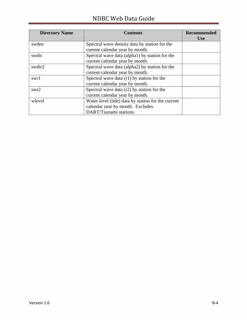
swden Spectral wave density data by station for the
current calendar year by month.
swdir Spectral wave data (alpha1) by station for the
current calendar year by month.
swdir2 Spectral wave data (alpha2) by station for the
current calendar year by month.
swr1 Spectral wave data (r1) by station for the
current calendar year by month.
swr2 Spectral wave data (r2) by station for the
current calendar year by month.
wlevel Water level (tide) data by station for the current
calendar year by month. Excludes
DART/Tsunami stations.