Embed Size (px)
Citation preview
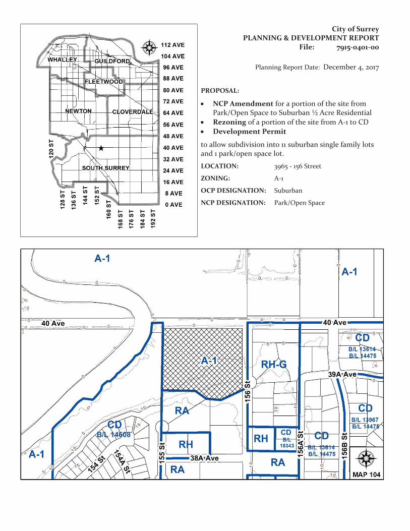
City of SurreyPLANNING & DEVELOPMENT REPORT
File: 7915-0401-00
Planning Report Date: December 4, 2017
PROPOSAL:
• NCP Amendment for a portion of the site from Park/Open Space to Suburban ½ Acre Residential
• Rezoning of a portion of the site from A-1 to CD• Development Permit
to allow subdivision into 11 suburban single family lots and 1 park/open space lot.
LOCATION: 3965 - 156 Street
ZONING: A-1
OCP DESIGNATION: Suburban
NCP DESIGNATION: Park/Open Space
Staff Report to Council
File: 7915-0401-00
Planning & Development Report
Page 2
RECOMMENDATION SUMMARY
• By-law Introduction and set date for Public Hearing for Rezoning of a portion of the site.
• Approval to draft Development Permit.
DEVIATION FROM PLANS, POLICIES OR REGULATIONS
• The applicant is seeking an amendment to the Rosemary Heights Central Neighbourhood Concept Plan (NCP) to redesignate a portion of the site from "Park/Open Space" to "Suburban ½ Acre Residential".
• The proposal does not fully comply with the DP2 Hazard Lands Design Guidelines which indicates that subdivisions are not permitted within flood prone areas of the City, or with City Policy No. O-55 (Development within the Nicomekl and Serpentine River Floodplains) which indicates that development proposals within the floodplain will not be supported unless they comply with existing zoning or local area / neighbourhood plan designations.
RATIONALE OF RECOMMENDATION
• The proposal complies with the site’s Official Community Plan (OCP) Designation.
• The NCP currently designates the entire site as Park/Open Space. The subject application proposes an NCP amendment to redesignate a portion of the site to Suburban ½ Acre Residential to permit the proposed development.
• The configuration and size of the proposed park is acceptable to Parks, Recreation and Culture. Furthermore, the proposal meets the City’s requirement for a ±2 acre park site at this location, as discussed in Corporate Report No. L005, which was considered by Council at the July 26, 2010 Regular Council Land Use meeting. The proposed park/open space will be conveyed to the City at no cost.
• No significant opposition to the proposed NCP amendment was raised by area residents through the public consultation process, which included a Public Information Meeting.
• The proposal does not comply with current City policy, as some portions of the proposed subdivision encroach into the floodplain. However, in light of ongoing discussions and negotiations with the City on the purchase and development of the property that precede City policy, historical authorized filling on the site, and the fact that none of the proposed homes on any of the proposed lots are located within the floodplain, there are merits in considering the proposal.
• The development proposal meets the minimum setback requirements of Part 7A, Streamside Protection, of Surrey Zoning By-law, 1993, No. 12000, as amended. The streamside protection areas and the portion of GIN located within the northwest corner of the subject site will be conveyed to the City as open space.
Staff Report to Council
File: 7915-0401-00
Planning & Development Report
Page 3
RECOMMENDATION
The Planning & Development Department recommends that:
1. a By-law be introduced to rezone a portion of the subject site, shown as Block B on the attached Survey Plan (Appendix II), from "General Agricultural Zone (A-1)" to "Comprehensive Development Zone (CD)" and a date be set for Public Hearing.
2. Council authorize staff to draft Development Permit No. 7915-0401-00 for Hazard Lands and Sensitive Ecosystems, generally in accordance with the Ecosystem Development Plan prepared by Ken Lambertson, dated August 2017 and the Geotechnical Investigation Report prepared by Geopacific Consultants Ltd., dated October 10, 2017.
3. Council instruct staff to resolve the following issues prior to final adoption:
(a) ensure that all engineering requirements and issues including restrictive covenants, dedications, and rights-of-way where necessary, are addressed to the satisfaction of the General Manager, Engineering;
(b) submission of a subdivision layout to the satisfaction of the Approving Officer;
(c) submission of a finalized tree survey and a statement regarding tree preservation to the satisfaction of the City Landscape Architect;
(d) demolition of existing buildings and structures to the satisfaction of the Planning and Development Department;
(e) submission of a finalized lot grading plan to the satisfaction of the Planning & Development Department;
(f) registration of a Section 219 Restrictive Covenant to prohibit building construction within 10 metres (33 ft.) of the toe of the existing slope at the rear of proposed Lots 1 to 4;
(g) registration of a Section 219 Restrictive Covenant to indemnify the City against possible damages as a result of flooding;
(h) registration of a Restrictive Covenant for tree preservation on lots containing tree preservation areas in accordance with the finalized tree preservation plan;
(i) the applicant satisfy the deficiency in tree replacement on the site, to the satisfaction of the Planning and Development Department;
(j) conveyance of all of the proposed open space to the City, at no cost to the City, as agreed to by the applicant; and
(k) the applicant obtain the necessary approvals from the Ministry of Forests Lands Natural Resources and Oceans (FLRNRO) for impacts on watercourses for road frontage works on 156 Street.
Staff Report to Council
File: 7915-0401-00
Planning & Development Report
Page 4
4. Council pass a resolution to amend the Rosemary Heights Central Neighbourhood Concept Plan to redesignate a portion of the land from "Park/Open Space" to "Suburban ½ Acre Residential" when the project is considered for final adoption (Appendix VIII).
REFERRALS
Engineering: The Engineering Department has no objection to the project subject to the completion of Engineering servicing requirements as outlined in Appendix III.
School District: Projected number of students from this development:
4 Elementary students at Rosemary Heights Elementary School2 Secondary students at Earl Marriott Secondary School
(Appendix IV).
The applicant has advised that the dwelling units in this project are expected to be constructed and ready for occupancy by Winter, 2019.
Parks, Recreation & Culture:
This property is designated entirely as park in the Rosemary Heights Central NCP. Should this proposal be supported, Parks will accept the area shown as parkland without compensation.
SITE CHARACTERISTICS
Existing Land Use: Single family dwelling.
Adjacent Area:
Direction Existing Use OCP/NCP Designation
Existing Zone
North (Across 40 Avenue): Single family dwelling/farm
Agricultural A-1
East (Across 156 Street): Single family dwellings/Greenbelt
OCP: Suburban
NCP: Suburban ½ Acre Residential/Park/Open Space
RH-G
South: Single family dwellings
Suburban/Suburban 1 Acre Residential
RA
West: Greenbelt OCP: Urban
NCP: Park/Open Space
CD (By-law No. 14608)
Staff Report to Council
File: 7915-0401-00
Planning & Development Report
Page 5
JUSTIFICATION FOR PLAN AMENDMENT
• The Rosemary Heights Central NCP currently designates the entire site as Park/Open Space.
• At the July 26, 2010 Regular Council – Land Use meeting, Council received Corporate Report No. L005 from the General Manager, Planning and Development and authorized staff to undertake a process to review the NCP land use designation for the subject property including consultation with the community and provide a report back to Council complete with recommendations (Resolution No. R10-1396).
• Subsequent to this Council resolution, in discussion with the City Solicitor, it was determined that it would be more appropriate to address the site’s land use through a development application. As a result, the applicant has submitted the subject development application.
• An amendment to the North Grandview Heights NCP from "Park/Open Space" to "Suburban ½ Acre Residential" is required for a portion of the site to accommodate the proposed residential uses on the site.
• In consideration of the proposed NCP amendment to increase the density from "Park" to "Suburban ½ Acre Residential", the applicant is proposing to convey 34% of the site area as open space as follows:
o Dedication of 5% of the site area (1,131 square metres (0.28 acres)) in accordance with the provision identified in the Local Government Act; and
o Conveyance of 29% of the site area as open space (6,624 square metres (1.64 acres)).
• The land use concept will allow for the protection of 4 watercourses, including the Nikomekl River, land for the Biodiversity Conservation Strategy’s Green Infrastructure Network (GIN) Corridor, and residential housing in a low density single family form.
• In total, the proposal will convey at no cost to the City, approximately 0.78 hectares (1.91 acres) of open space, including the riparian areas of four (4) watercourses and a portion of the Green Infrastructure Network (GIN) as identified in the City’s Biodiversity Conservation Strategy.
• The configuration and size of the proposed park/open space in the applicant’s proposal is acceptable to Parks, Recreation and Culture. The proposed layout meets the City’s requirement for a ±2 acre park site at this location.
• No significant opposition was raised by area residents through neither the public notification process nor at the Public Information Meeting held by the applicant.
• The proposed subdivision layout and sizes of the proposed lots is considered reasonable for the suburban context of the subject site.
Staff Report to Council
File: 7915-0401-00
Planning & Development Report
Page 6
DEVELOPMENT CONSIDERATIONS
Background
• The proposed development is located in the Rosemary Heights Central Neighbourhood Concept Plan (NCP) area.
• The 2.3 hectare (5.6 acre) site is designated "Park/Open Space" in the Rosemary Heights Central NCP, "Suburban" in the Official Community Plan (OCP) and is zoned "General Agricultural Zone (A-1)".
• The northerly portion of the site (+/- 3 acres) is located within the 200 year Flood Plain of the Nicomekl River, as defined by the Province of British Columbia.
• The site was the subject of a number of approved soil deposition permits prior to the development application. These permits were to allow portions of the lot to be raised beyond the 200 year flood plain. Also, the permits were issued prior to implementation of Policy O-55 to Regulate Development within the Serpentine and Nicomekl River Flood Plain.
• To the north of 40 Avenue the site abuts agricultural lands zoned A-1 that are within the Agricultural Land Reserve. To the south are existing established suburban acreage lots zoned One-Acre Residential (RA). To the east are suburban residential lots zoned Half-Acre Residential Gross Density Zone (RH-G) and a linear park (greenbelt) along 40 Avenue. To the west is an existing City park (greenbelt).
• There is an existing house on the southerly portion of the site with driveway access from 156 Street.
• Since June, 2002, the City’s Realty Services Division had been in discussions with the property owner with respect to acquisition of the property for park purposes. The property owner and the City have not been able to come to an agreement on the acquisition of the property by the City.
• At the July 26, 2010 Regular Council – Land Use meeting, Council considered Corporate Report L005, which identified the technical requirements for this park site, which is identified as a "Blueways" park in the Parks, Recreation and Culture Department’s Blueways Master Plan.
• Parks Recreation and Culture concluded that the parkland needs could be accommodated in the lowland floodplain portion of the property that is approximately 0.8 hectare (2.0 acres) in area.
Proposal
• The applicant proposes an OCP amendment to the Rosemary Heights Central NCP for a portion of the site from Park/Open Space to Suburban ½ Acre Residential and rezoning for a portion of the site from " General Agricultural Zone (A-1)" to "Comprehensive Development Zone (CD)" (based on the RH-G Zone) to allow subdivision into 11 suburban single family residential lots, and approximately 0.78 hectares (1.91 acres) of open space.

Staff Report to Council
File: 7915-0401-00
Planning & Development Report
Page 7
• A Hazard Lands Development Permit (for Flood Plain and Steep Slope) and a Sensitive Ecosystem Development Permit are also required as part of the subject application.
CD By-law
• The applicant is proposing a CD Zone for the site, which is to be based on the Half-Acre Residential Gross Density Zone (RH-G). The table below outlines the differences between the RH-G Zone and the proposed CD Zone:
RH-G Zone Proposed CD ZoneMinimum Lot Width 24 metres (80 ft.) 21 metres (69 ft.)
Minimum Lot Size 1,120 sq.m. (12,000 sq.ft.)
929 square metres (10,000 sq. ft.)
• The proposed CD Zone allows for lots with a minimum lot area of 929 square metres (10,000 sq. ft.) that are a minimum of 21 metres (69 ft.) wide and 30 metres (98 ft.) deep.
• The proposed lot width and lot area are less than the minimum lot width and area requirements of the RH-G Zone, which are a minimum of 24.0 metres (79 ft.) wide and 1,120 square metres (12,000 sq.ft.) in area.
• The maximum gross unit density permitted is 5 units per hectare (2 upa).
Site Access
• Access to the site is from the existing half-cul-de-sac bulb on 156 Street.
• 156 Street is physically separated from 40 Avenue. As part of the proposal, the applicant is proposing to extend 156 Street further north and to dedicate and construct a new east/west road to provide access and frontage to the proposed lots.
• 156 Street will remain physically separated from 40 Avenue and is not proposed to be opened or connected to 40 Avenue as part of the subject application.
• As part of the proposal, the applicant will be constructing the west side of 156 Street along the site’s frontage. There is an existing Class B ditch to the east side of the subject site, within the 156 Street road allowance. Construction of frontage works in that area will require approval from the Ministry of Forests Lands Natural Resources and Oceans (FLRNRO).
Sensitive Ecosystem (Streamside Areas and Green Infrastructure Network) Development Permit
• The subject site is located within a Development Permit Area for Sensitive Ecosystems under the Official Community Plan (OCP) due to its location within 50 metres (164 ft.) of four (4) streamside areas, including a Class A watercourse (the Nickomekl River) and with a portion of Green Infrastructure Network (GIN) as identified in the City’s Biodiversity Conservation Strategy. In order to address this requirement, the applicant has submitted an Ecosystem Development Plan prepared by Phoenix Environmental Services Ltd., dated August, 2017.
Staff Report to Council
File: 7915-0401-00
Planning & Development Report
Page 8
• The Ecosystem Development Plan has confirmed the location, classification and top-of-bank of the existing Class A watercourse, Class A/O ditches (2) and Class B watercourse that surround the site.
• The development proposal meets the minimum setback requirements of Part 7A, Streamside Protection, of Surrey Zoning By-law, 1993, No. 12000, as amended.
• The streamside protection areas and the portion of GIN located within the northwest corner of the subject site is included in the open space that will be conveyed to the City.
• The Ecosystem Development Plan has been reviewed by staff and found to be generally acceptable.
• The Ecosystem Development Plan will be incorporated into the requirements of the Sensitive Ecosystems Development Permit. Issuance of the DP will be required prior to final adoption of the Rezoning By-law.
Hazard Lands (Flood Prone Areas and Steep Slope) Development Permit
• The site is subject to a Development Permit for Hazard Lands in the OCP due to steep slopes in the southwest portion of the property in excess of 20% grade and because portions of the site are located within the 200 year floodplain of the Nickomekl River.
Hazard Lands – Steep Slopes
• The subject site is flat lying, with the exception of the southern portion where the escarpment slope rises at grades ranging from 20% to 50%, with the steepest sections located on the adjacent lands to the south.
• The applicant has submitted a geotechnical report prepared by Geopacific Consultants, dated October 102, 2017. The geotechnical report states that the land may be used safely for the intended use provided that the adjacent lots to the south of the subject site do not negatively impact the slope.
• A Section 219 Restrictive Covenant will be registered on the title of proposed Lots 1 to 4 to prohibit building construction within 10 metres (33 ft.) of the existing toe of the slope in the rear yards of these proposed lots.
Hazard Lands – Flood Prone
• A portion of the subject site is located within the 200-year floodplain of the Nicomekl River, as defined by the Province of British Columbia.
• The OCP DP2 Hazard Lands Guidelines indicate that subdivisions are not permitted within flood prone areas of the City. While the site is at the edge of the 200-year floodplain of the Nicomekl River, the site grading has been altered through various historical fill permits, resulting in changes to the floodplain edge over time.
Staff Report to Council
File: 7915-0401-00
Planning & Development Report
Page 9
• The extension of 39A Avenue, including the cul-de-sac bulb, and portions of the yards of proposed Lots 1, 2, 3, 8 and 11 are located within the current floodplain; however, portions of the proposed open space are located outside of the current floodplain edge (Appendix IX).
• Although a portion of the yards of proposed Lots 1, 2, 3, 8 and 11 are located within the current floodplain boundary, the applicant has demonstrated that none of the proposed new homes on these lots will be located within the floodplain. Notwithstanding, a Restrictive Covenant will be registered on the title of these lots to indemnify the City against possible damages as a result of flooding.
• The applicant’s agent will be working with the City to ensure all private and City infrastructure are outside the floodplain and that any proposed soil deposition and lot grading provide the same floodplain storage characteristics as the approved historical soil deposition permits on the site.
• The applicant has submitted a geotechnical report prepared by Geopacific Consultants, dated August 24, 2017, to address those portions of the development site that are located within the floodplain.
• Staff have reviewed the Geotechnical Report to confirm that the requirements identified in the OCP relative to Hazard Lands have been considered. No detailed analysis relative to the study’s findings have been carried out by staff.
• The geotechnical report includes drill exploration and comments pertaining to site preparation and foundation design. The Geotechnical Report addresses the Development Guidelines for Hazard Lands outlined in the Official Community Plan (OCP), and will be incorporated into the proposed Development Permit. Issuance of the DP will be required prior to Final Adoption of the Rezoning By-law.
Building Design Guidelines & Lot Grading
• The applicant retained Tynan Consulting Ltd. as the Design Consultant for this project. The Design Consultant has conducted a character study of the surrounding homes and, based upon those findings, has proposed a set of building design guidelines for the proposed lots (Appendix V).
• The designs for the proposed lots include Traditional (including English Country, English Tudor, English Manor and Cape Cod), Classical Heritage, Neo-Traditional and Neo-Heritage. The new homes would meet modern development standards relating to overall massing, and balance in each design, and to proportional massing between individual elements.
• The roofing will reflect the desirable style objectives, and will require a minimum pitch of 7:12.
• The only permissible roof materials would consist of cedar shingles, concrete roof tiles with a shake profile, and asphalt shingles with a raised ridge cap.
• A preliminary Lot Grading Plan, submitted by Coastland Engineering and Surveying Ltd. has been reviewed by the Building Division and is generally acceptable.
Staff Report to Council
File: 7915-0401-00
Planning & Development Report
Page 10
• In-ground basements are proposed based on the lot grading and tree preservation information that was provided by the applicant. The information has been reviewed by staff and found to be generally acceptable; however a final Lot Grading Plan is required prior to Final Adoption.
PRE-NOTIFICATION
• Pre-notification letters were sent on March 23, 2016 and 2 development proposal signs were installed on April 8, 2016.
• To date, staff have received the following correspondence.
o 2 emails: one requesting information about the proposal and one requesting that 156 Street remain physically separated from 40 Avenue;
o 2 phone calls: one requesting information about the proposal and both requesting that 156 Street remain physically separated from 40 Avenue; and
o 1 letter expressing concern about the proposal.
• A summary of the concerns received in the letter is noted below with staff comments shown in italics.
o Concerns that the development proposal will result in a loss of privacy for neighbours to the south.
(The lots to the south of the subject site are located at the top of a steep slope and are therefore significantly higher than the homes proposed on the subject site. The development proposal is not expected to result in a loss of privacy for neighbours to the south as the difference in grade precludes overlook.)
o Concerns about the loss of Parkland for the City and for the Rosemary Heights community.
(The Rosemary Heights Central NCP designates the entire 2.3 hectare (5.6 acre) site for Park. The applicant is proposing to convey approximately 0.78 hectares (1.91 acres), representing approximately 34% of the gross area of the site, as open space at no cost to the City).
o Concerns about the impact of the development proposal on the existing views of the neighbours to the south.
(Based on the grade difference of the lots to the south of the subject site and the 10 metre setback for building construction from the toe of the slope for proposed Lots 1-4, the development proposal is not expected to significantly impact the views of the neighbours to the south.)
Staff Report to Council
File: 7915-0401-00
Planning & Development Report
Page 11
o Concerns about slope stability.
(To protect the slope stability, a Section 219 Restrictive Covenant will be registered on the title of proposed Lots 1 to 4 to prohibit building construction within 10 metres (33 ft.) of the toe of the existing escarpment slope.)
o Concerns about the impact of construction of the lots, especially the pilings, on adjacent residents.
(The applicant advises that they will not be pursuing piling. Rather, they will utilize other options that are less disruptive to the neighbours including pre-loading, raft slabs and stripping down to suitable grade prior to structurally filling.)
o Concerns about a pond on the subject site.
(An artificial pond was previously located on the subject site. It was used as irrigation for the field and as a swimming hole. The pond was not connected to any watercourses and therefore was not considered to be of fisheries value. The pond was filled in sometime between 2014 and 2015.)
o Concerns about the impact of the development proposal on nearby eagles and local wildlife.
(There are no Eagle’s Nests located on or adjacent to the subject site. As 0.78 hectares (1.91 acres) of open space is proposed to be conveyed to the City, there will continue to be opportunities for local wildlife to access the Serpentine/Nicomekl Biodiversity Conservation Strategy (BCS) management area, which is part of a Regional BCS Corridor.)
Public Information Meeting
• The applicant held a Public Information (PIM) meeting on May 15, 2017 at the Morgan Elementary School from 6:00 pm to 8:00 pm. A total of 15 residents signed in, representing 12 households, of which 11 submitted comment sheets. All 11 respondents expressed support for the development proposal. 2 respondents commented that 156 Street should remain physically separated from 40 Avenue and 1 respondent indicated that while they support the proposal, they would prefer to see the entire subject site be developed as park.
Staff Report to Council
File: 7915-0401-00
Planning & Development Report
Page 12
TREES
• Trevor Cox, ISA Certified Arborist of Diamond Head Consulting Ltd. prepared an Arborist Assessment for the subject property. The table below provides a summary of the tree retention and removal by tree species:
Table 1: Summary of Tree Preservation by Tree Species:Tree Species Existing Remove Retain
Alder and Cottonwood Trees
Alder 4 0 4Deciduous Trees
(excluding Alder and Cottonwood Trees)Cherry 2 2 0
Bigleaf Maple 1 1 0Weeping Willow 3 3 0
Coniferous TreesNorway Spruce 4 2 2
Western Redcedar 23 13 10White Spruce 1 1 0
Total (excluding Alder and Cottonwood Trees) 34 22 12
Additional [Estimated] Trees in the proposed Riparian Area
17 0 17
Total Replacement Trees Proposed (excluding Boulevard Street Trees) 30
Total Retained and Replacement Trees 42
Contribution to the Green City Fund $5,600
• The Arborist Assessment states that there are a total of 34 protected trees on the site, excluding Alder trees. 4 existing trees, approximately 11% of the total trees on the site, are Alder trees. It was determined that 12 trees can be retained as part of this development proposal. The proposed tree retention was assessed taking into consideration the location of services, building footprints, road dedication and proposed lot grading.
• Table 1 includes an additional 17 protected trees that are located within the proposed open space. The trees within the proposed open space will be retained, except where removal is required due to hazardous conditions. This will be determined at a later time, in consultation with the Parks, Recreation and Culture Department.
Staff Report to Council
File: 7915-0401-00
Planning & Development Report
Page 13
• For those trees that cannot be retained, the applicant will be required to plant trees on a 1 to 1 replacement ratio for Alder trees, and a 2 to 1 replacement ratio for all other trees. This will require a total of 44 replacement trees on the site. Since only 30 replacement trees can be accommodated on the site based on a minimum of 3 trees per lot (some lots contain a number of retained trees which precludes replacement trees), the deficit of 14 replacement trees will require a cash-in-lieu payment of $5,600, representing $400 per tree, to the Green City Fund, in accordance with the City’s Tree Protection By-law.
• In summary, a total of 42 trees are proposed to be retained or replaced on the site with a contribution of $5,600 to the Green City Fund.
BIODIVERSITY CONSERVATION STRATEGY
• The City of Surrey Biodiversity Conservation Strategy (BCS) Green Infrastructure Network (GIN) map, adopted by Council on July 21, 2014 (Corporate Report No. R141; 2014), identifies a portion of a Regional BCS Corridor within the northwest corner of the subject site in the Serpentine/Nicomekl BCS management area, with high ecological value.
• The BCS further identifies the GIN area of the subject site as having a moderately high habitat suitability rating, derived from species at risk presence, species accounts and known ecosystem habitat inventories. The BCS recommends a target Corridor width of 20 meters, a portion of which falls on the subject site.
• Protecting green infrastructure Hubs (large habitat areas) and Sites (smaller habitat areas) is critical to preserving natural habitat refuges and a diversity of habitat features while maintaining/enhancing Corridors ensures connectivity between fragmented hubs for genetic variation throughout the City. The closest Biodiversity Hub connection in the GIN to the subject site is Hub J, which is located in the Serpentine/Nicomekl Management Area.
• The development proposal conserves 100% of the target GIN area on the subject site. This method of GIN retention will assist in the long term protection of the natural features and allows the City to better achieve biodiversity at this location consistent with the guidelines contained in the BCS.
SUSTAINABLE DEVELOPMENT CHECKLIST
The applicant prepared and submitted a sustainable development checklist for the subject site on November 1, 2017. The table below summarizes the applicable development features of the proposal based on the seven (7) criteria listed in the Surrey Sustainable Development Checklist.
Sustainability Criteria
Sustainable Development Features Summary
1. Site Context & Location
(A1-A2)
• The site is located within the Central Rosemary Heights NCP.• The proposal complies with the site’s Suburban OCP land use
designation. • An NCP amendment is required on a portion of the site from
"Park/Open Space" to "Suburban ½ Acre Residential" is requested.
Staff Report to Council
File: 7915-0401-00
Planning & Development Report
Page 14
Sustainability Criteria
Sustainable Development Features Summary
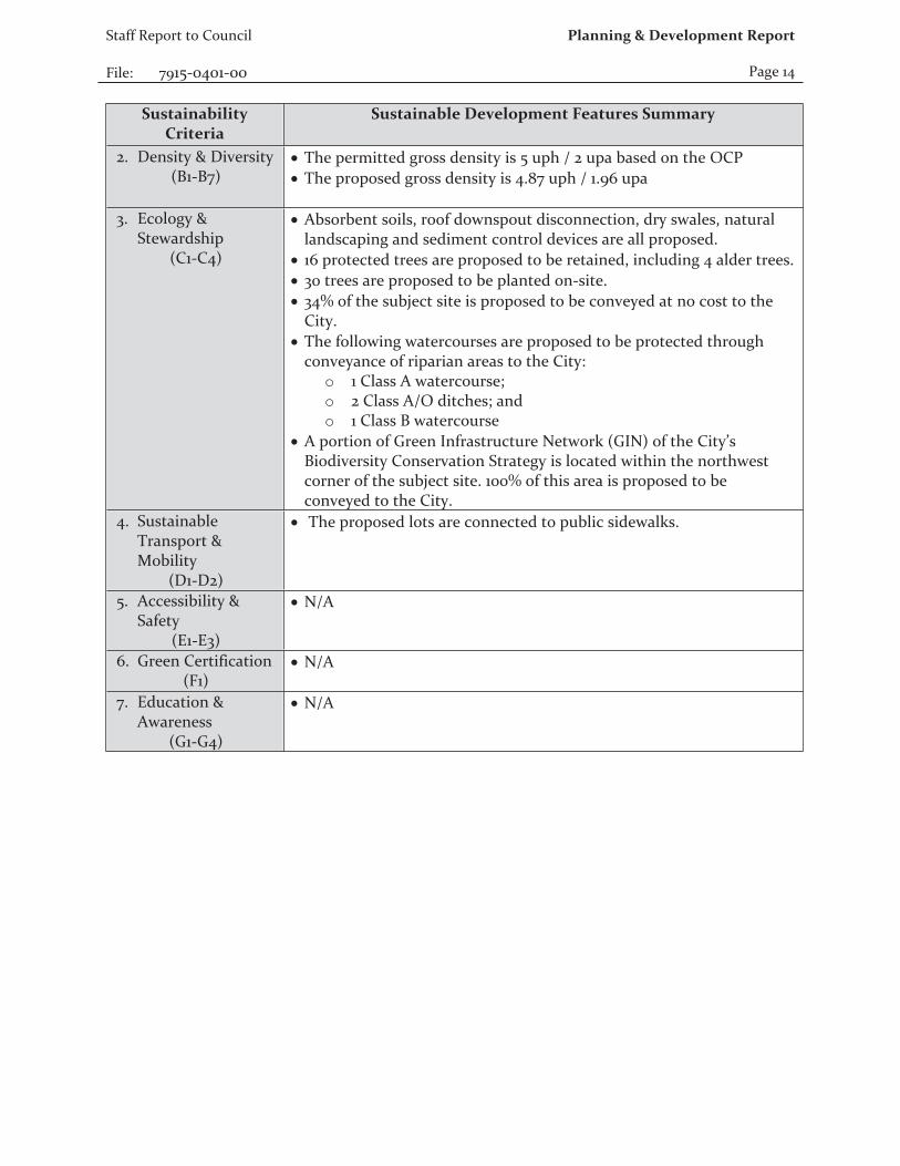
2. Density & Diversity (B1-B7)
• The permitted gross density is 5 uph / 2 upa based on the OCP• The proposed gross density is 4.87 uph / 1.96 upa
3. Ecology & Stewardship
(C1-C4)
• Absorbent soils, roof downspout disconnection, dry swales, natural landscaping and sediment control devices are all proposed.
• 16 protected trees are proposed to be retained, including 4 alder trees. • 30 trees are proposed to be planted on-site. • 34% of the subject site is proposed to be conveyed at no cost to the
City.• The following watercourses are proposed to be protected through
conveyance of riparian areas to the City:o 1 Class A watercourse;o 2 Class A/O ditches; ando 1 Class B watercourse
• A portion of Green Infrastructure Network (GIN) of the City’s Biodiversity Conservation Strategy is located within the northwest corner of the subject site. 100% of this area is proposed to be conveyed to the City.
4. Sustainable Transport & Mobility
(D1-D2)
• The proposed lots are connected to public sidewalks.
5. Accessibility & Safety
(E1-E3)
• N/A
6. Green Certification (F1)
• N/A
7. Education & Awareness
(G1-G4)
• N/A
Staff Report to Council
File: 7915-0401-00
Planning & Development Report
Page 15
INFORMATION ATTACHED TO THIS REPORT
The following information is attached to this Report:
Appendix I. Lot Owners and Action Summary (Confidential) and Project Data SheetsAppendix II. Survey Plan and Proposed Subdivision Layout Appendix III. Engineering SummaryAppendix IV. School District CommentsAppendix V. Building Design Guidelines SummaryAppendix VI. Summary of Tree Survey and Tree PreservationAppendix VII. Proposed CD By-lawAppendix VIII. NCP Amendment PlanAppendix IX. Floodplain Boundary
INFORMATION AVAILABLE ON FILE
• Ecosystem Development Plan prepared by Ken Lamberson, R.P.Bio, dated August, 2017.• Geotechnical Investigation Report prepared by Geopacific Consultants Ltd., dated
October 10, 2017.
original signed by Ron Hintsche
Jean LamontagneGeneral ManagerPlanning and Development
TH/da
APPENDIX I HAS BEEN
REMOVED AS IT CONTAINS
CONFIDENTIAL INFORMATION
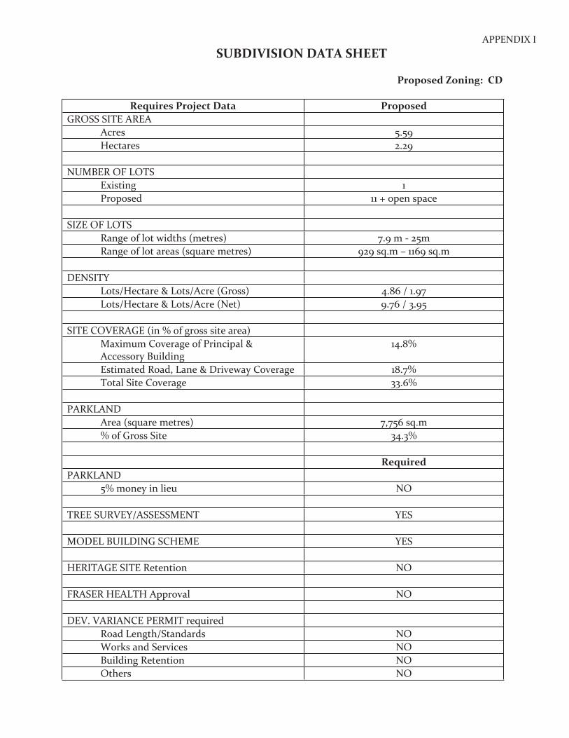
APPENDIX ISUBDIVISION DATA SHEET
Proposed Zoning: CD
Requires Project Data ProposedGROSS SITE AREA
Acres 5.59Hectares 2.29
NUMBER OF LOTSExisting 1Proposed 11 + open space
SIZE OF LOTSRange of lot widths (metres) 7.9 m - 25mRange of lot areas (square metres) 929 sq.m – 1169 sq.m
DENSITYLots/Hectare & Lots/Acre (Gross) 4.86 / 1.97Lots/Hectare & Lots/Acre (Net) 9.76 / 3.95
SITE COVERAGE (in % of gross site area)Maximum Coverage of Principal & Accessory Building
14.8%
Estimated Road, Lane & Driveway Coverage 18.7%Total Site Coverage 33.6%
PARKLANDArea (square metres) 7,756 sq.m% of Gross Site 34.3%
RequiredPARKLAND
5% money in lieu NO
TREE SURVEY/ASSESSMENT YES
MODEL BUILDING SCHEME YES
HERITAGE SITE Retention NO
FRASER HEALTH Approval NO
DEV. VARIANCE PERMIT requiredRoad Length/Standards NOWorks and Services NOBuilding Retention NOOthers NO
APPEN
DIX
II
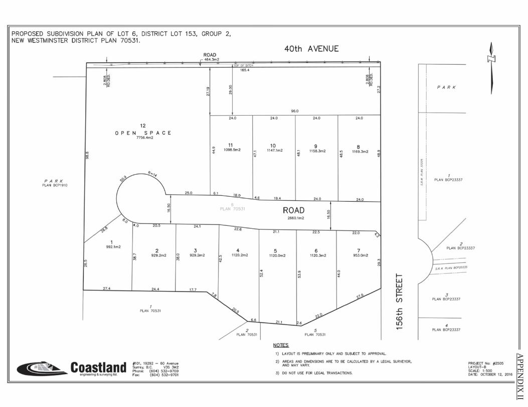
PROPOSED SUBDIVISION PLAN OF LOT 6, DISTRICT LOT 153, GROUP 2, NEW WESTMINSTER DISTRICT PLAN 70531 .
12
0 P E N S P A C E 7756.4m2
"' ,; O>
~ r PARK I PLAN BCP1910
~I ! .o 20.5 I
992.1m2 I 2
I; 929.2m2 Cl ~ I"'
"' N
21.,j I 24.4 I
I PLAN 70531
jl101, 19292 - 60 Avenue Coastland Surrey. B.C. V3S 3M2 P~one: (604) 532-9700
engineering & survey,ng tld. fox: (604) 532-9701
25,0
24.1
3
ROAD 464.Jm2
~ ..: N
I
I O>
I :t
§J
.QE [H_f_C_H
8 gj
J 24.0
11 1098.5m2
165.4
1~
I ~ 4.6
I)
PLAN'"~-
I ~
4 929.2m 2 ~ 1120.2m2
)J_.J_ I I
~ .. Ml
2 PLAN 70531
.... "' "'
40th AVENUE
96.0
24.0 I 24.0 I
10 Ii 9 I; 1147.1m2 1158.Jm2
I I I 19.4 24.0
I
ROAD ~ 2660.1m2 <D
21.1 22.5
5 6 1120.0m2 1120.3m2
"' 0 .,; .. "' ..
I I
21 .1 .6
5 PLAN 70531
tiQIES.
24.0
8
gl~ NO
,O!
1169.3m2
24.0
22.0
7 953.0m2
N ..: N
"' ~i
I
~t''
I ..,I
'" N
I
........-1
1) LAYOUT IS PRELIMINARY ONLY ANO SUBJECT TO APPROVAL
I-w w 0::: I-(/)
.!: +-' (0 l{) ..-
2) AREAS ANO DIMENSIONS ARE TO BE CALCULATED BY A LEGAL SURVEYOR. ANO MAY VARY.
3) 00 NOT USE fOR LEGAL TRANSACTIONS.
PARK
' "' ~ ..,
I~ ' I
PLAN BCP23337
~ / PLAN ef P23337
L--------
I J PLAN BCP23337
I 4 PLAN BCP23337
PRO-E:CT No: #2505 LAYOUT- 8 SCALE: 1: 500 DA lE: OCTOBER 12, 2016
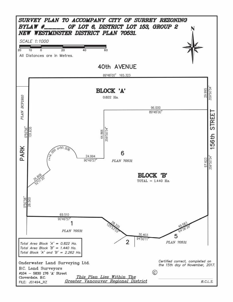
SURVEY PLAN TO ACCOMPANY CITY OF SURREY REZONING BYLA 1' #. OF LOT ~ DIS'l'RICT LOT 163, OROUP 2 N NE1f W.l!S'l'JIINS"l'ER DIS'l'RICT PLAN 7063L SCALE 1: 1000 - -- -20 10 0 20
All Distances are in Metres.
: 0 <O C> _lO <O 0 . I!) ~ • 0 0 ~
~o l() 0 - If) 0 . L() <O c::,N
69.510 90'49'57'
1 PLAN 70531
Total Area Block 'A' = 0.822 Ha. Total Area Block '8' = 1.440 Ha. Total Block 'A' and '8' = 2.262 Ha.
40 60
40th AVENUE 89'48'00" 165.323
BLOCK 'A'
24.994 90'49'57"
0.822 Ha.
:v <O lf) <O -co 0
. If) ...... v O>
l() n
6 PLAN 70531
96.000 89'48'00"
BLOCK 'B' TOTAL = 1.440 Ha.
30.403 94'50'11"
PLAN 70531
l() ~ O> -O> 0
. If) O> • N~
n
1-w w I:!: (/)
£. +" (0 l{) ,--
-v n lO N -<O 0 r....: \0 O> O>
l() n
Onderwater Land Surveying Ltd. B.C. Land Surveyors
Certified correct, completed on the 15th day of November, 2017.
#104 - 5630 176 'A' St reet Clover dale, B.C. FILE: JS1494 __RZ
This Plan Lies Within The Greater Vancouver Regional Distric t
® 8.C.L.S.
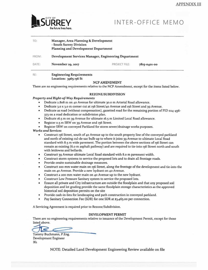
APPENDIX III
ltsURREv ~ the future lives here.
INTER-OFFICE MEMO
TO. Manager, Area Planning & Development - South Surrey Division Planning and Development Department
FROM : Development Services Manager, Engineering Department
DATE : November 29, 2017 PROJECT FILE :
RE: Engineering Requirements Location: 3965 156 St
NCP AMENDMENT There are no engineering requirements relative to the NCP Amendment, except for the items listed below.
REZONE/SUBDMSION Property and Right-of-Way Requirements
• Dedicate 2.808 m on 40 Avenue for ultimate 30.0 m Arterial Road allowance. • Dedicate 3.0 x 3.0 m corner cut at 156 Street/40 Avenue and 156 Street and 39 Avenue. • Dedicate as road (without compensation) , gazetted road for the remaining portion of PID 024-456-
373 on a road dedication or subdivision plan. • Dedicate 16.5 m on 39 Avenue for ultimate 16.5 m Limited Local Road allowance. • Register 0.5 m SRW on 39 Avenue and 156 Street. • Register SRW on conveyed Parkland for storm sewer/drainage works purposes.
Works and Services • Construct 156 Street, south of 40 Avenue up to the south property line of the conveyed parkland
and north of existing cul-de-sac bulb up to where it joins 39 Avenue to ultimate Local Road standard with 8.5 m wide pavement. The portion between the above sections of156 Street can remain as existing (6.o m asphalt pathway) and are required to tie-into 156 Street north and south with letdowns and bollards.
• Construct 39 Avenue ultimate Local Road standard with 8.o m pavement width. • Construct storm systems to service the proposed lots and to drain all frontage roads . • Provide onsite sustainable drainage measures. • Construct 200 mm water main on 156 Street, along the frontage of the development and tie-into the
main on 40 Avenue. Provide a new hydrant on 40 Avenue. • Construct a 200 mm water main on 40 Avenue up to the new hydrant. • Construct Low Pressure Sanitary system to service the proposed lots. • Ensure all private and City infrastructure are outside the floodplain and that any proposed soil
deposition and lot grading provide the same floodplain storage characteristics as the approved historical soil deposition permits on the site
• Provide cash-in-lieu for landscaping and path construction in conveyed parkland. • Pay Sanitary Connection Fee (SDR) for one SDR at S3,465.oo per connection.
A Servicing Agreement is required prior to Rezone/Subdivision.
DEVELOPMENT PERMIT There are no engineering requirements relative to issuance of the Development Permit, except for those listed above.
~ c:::::::> Tommy Buchmann, P.Eng. Development Engineer IK1
-NOTE: Detailed Land Development Engineering Review available on file
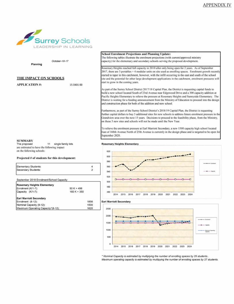
APPENDIX IV
Surrey Schools LEADERSHIP IN LEARNING
October-10-17 Planning
T H E I M PACT ON SCHOOLS
APPLICATION#:
SUMMA RY
15 040100
The proposed 11 single family lots arc estimated 10 have the following impact on the fol lowing schools:
Projected # of students for this development:
Elementary Students: Secondary Students:
Se !ember 2018 EnrolmenVSchool Ca acit
Rosemary Heights Elementary Enrolment (K/1-7): Capacity (K/1-7):
Earl Marriott Secondary Enrolment (8-12): Nominal Capacity (8-12): Maximum O eratin Ca acit • 8-12 ;
50 K + 496 160 K + 350
4 2
1856 1500 1620
School Enrolment Projections and Planning pdatc: The following tables illustrate the enrolment projections (with current/approved ministry capacity) for the elementary and secondary schools serving the proposed development.
Rosemary Height reached full capacity in 2010 after only being open for 2 years. As of eptember 2017, there are 3 portable + 4 modular unit on si te u ed a enrol li ng paces. Enrolment growth recently staned 10 taper in this catchment, however, with the infill occurring to the east and south of the school ite and the potent ial for other large development applications in the catchment , enrolment pres ures will
stan to grow in the coming years.
As pan of the Surrey chool Oi trict 20 17/ 18 Capital Plan, the District is requesting capital fund 10
build a new chool located South of 23 rd Avenue near dgewood Drive and a 300 capacity add ition at Pacific Heights Elementary to relieve the pressure al Rosemary Height and unnyside Elementary. The Di trict i waiting for a funding announcement from the Ministry of ducation to proceed into the d ign and construction phase for both of the addition and new school.
Funhennore, as pan of the Surrey School District 's 2018/ 19 Capital Plan, the Dist.rict is requesting funher capital dollars to buy 3 addi ti onal si tes for new schools to address future enrolment pressure in the Grandview area over the next 15 years. Decisions to proceed to the feasibility phase, from the Ministry, on these 3 new sites and schools will not be made unril the New Year.
To rel ieve the enrolment pressure at Earl Marriou Secondary, a new 1500 capacity high school located East of 168th Avenue North of 25th Avenue is currently in the deign phase and i targeted 10 be open fo September 2020.
Rosemary Heights Elementary
620
600 +----------------=---~-~-=--=----·_ .. __ ....... --580 +----------,.,,-~,·------------------------< _,............ ..,, 560 +------"",--, ---, ,__----------------~ ,..,_., 540 +--------------------------1
520 +---------------------------<
500 +-------------------------
480 +-------------------------460 J--~-~----~-~-~----~-~-~---1
2014 2015 2016 2017 2018 2019 2020 2021 2022 2023 2024
Earl Marriott Secondary
2500 .-------------------------,
2000 , - ,.,,,.,- -~-- -~-- -- -. - -- -- ----- - · -- --\,
' 1500 .... ---1000 +-------------------------1
500 !-------------------------~ Ot---~ -~-~-- --~-~-~-~ --~-~ - --t
2014 2015 2016 2017 2018 2019 2020 2021 2022 2023 2024
------
• Nominal Capacity is estimated by multiplying the number of enrolling spaces by 25 students .. Maximum operating capacity is estimated by multipying the number of enrolling spaces by 27 students.
APPENDIX V
BUILDING GUIDELINES SUMMARY
Surrey Project no: 7915-0401-00 Project Location: 3965 - 156 Street, Surrey, B.C. Design Consultant: Tynan Consulting Ltd., (Michael E. Tynan)
The draft Building Scheme proposed for this Project has been filed with the City Clerk. The following is a summary of the Residential Character Study and the Design Guidelines which highlight the important features and form the basis of the draft Building Scheme.
1. Residential Character
1.1 General Description of the Existing and/or Emerging Residential Character of the Subject Site:
The subject site is located within an old suburban/ agricultural area. Adjacent to the west side of the site is low lying (Om to 1.0m geodesic) park lands near the Nikomekl River which is only 24 metres from the northwest corner of the subject site.
North of the site is agricultural land, zoned A-1, most of which is open land (few structures). There is one home clearly visible from the street, at 15597 - 40 Avenue, a 1970's old urban Basement Entry home with a box-like massing design, prominent sundeck over two thirds of the width of the home, with a concrete tile roof, vinyl siding, and brick accent. This home does not provide suitable context for a post year 2016 RH-G zone site. Also north of the site, but east of the home described above is Mary's Garden Market which contains several agricultural buildings in good condition , but no context homes.
East of the site, in the 3800 and 3900 blocks of 156 Street are numerous suburban-estate TwoStorey homes constructed on RH-G (dominant), RH, and RA zoned lots. These homes are 3500 -5000 sq.ft Two-Storey type, most of which can be classified as "Traditional" or "Nee-Traditional" styles. The homes are designed to a modern standard with well balanced, consistently proportioned, architecturally interesting mid-scale massing characteristics. These homes have 8: 12 to 12: 12 main common hip, common gable, Boston Gable, or Boston Hip roofs with cedar shingles or concrete tile roof surfaces. Gable ends are articulated with shingles or other wood detailing, or stucco with Tudor style battens. Homes are clad in stucco, and most have a significant stone accent. The trim and detai ling standard and quality of exterior materials on many of these homes are clearly above average, providing excellent architectural context for the subject site.
1.2 Features of Surrounding Dwellings Significant to the Proposed Building Scheme:
1) Context Homes: There are several homes in this area that provide acceptable architectural context for the subject site, including 3877, 3915, 3926, 3912, 3896, 3886, and 387 4 - 156 Street. These homes meet new massing design standards in which various projections on the front of the home are proportionally consistent with one another, are well balanced across the fa9ade, are visually pleasing, and are architecturally interesting. These new homes provide an appropriate standard for future development in this area, and emulating the standards found on these homes will reinforce the desirable emerging trend. Therefore,
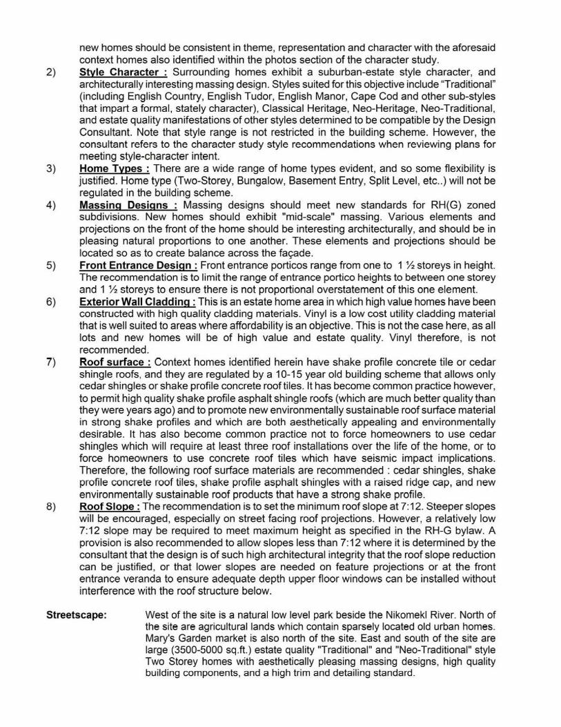
new homes should be consistent in theme, representation and character with the aforesaid context homes also identified within the photos section of the character study.
2) Style Character : Surrounding homes exhibit a suburban-estate style character, and architecturally interesting massing design. Styles suited for this objective include 'Traditional" (including Engl ish Country, English Tudor, English Manor, Cape Cod and other sub-styles that impart a formal, stately character), Classical Heritage, Neo-Heritage, Neo-Traditional, and estate quality manifestations of other styles determined to be compatible by the Design Consultant. Note that style range is not restricted in the building scheme. However, the consultant refers to the character study style recommendations when reviewing plans for meeting style-character intent.
3) Home Types : There are a wide range of home types evident, and so some flexibility is justified. Home type (Two-Storey, Bungalow, Basement Entry, Split Level, etc .. ) will not be regulated in the building scheme.
4) Massing Designs : Massing designs should meet new standards for RH(G) zoned subdivisions. New homes should exhibit "mid-scale" massing. Various elements and projections on the front of the home should be interesting architecturally, and should be in pleasing natural proportions to one another. These elements and projections should be located so as to create balance across the fa9ade.
5) Front Entrance Design: Front entrance porticos range from one to 1 % storeys in height. The recommendation is to limit the range of entrance portico heights to between one storey and 1 % storeys to ensure there is not proportional overstatement of this one element.
6) Exterior Wall Cladding : This is an estate home area in which high value homes have been constructed with high quality cladding materials. Vinyl is a low cost utility cladding material that is well suited to areas where affordability is an objective. This is not the case here, as all lots and new homes will be of high value and estate quality. Vinyl therefore, is not recommended.
7) Roof surface : Context homes identified herein have shake profile concrete tile or cedar shingle roofs, and they are regulated by a 10-15 year old building scheme that allows only cedar shingles or shake profile concrete roof tiles. It has become common practice however, to permit high quality shake profile asphalt shingle roofs (which are much better quality than they were years ago) and to promote new environmentally sustainable roof surface material in strong shake profiles and which are both aesthetically appealing and environmentally desirable. It has also become common practice not to force homeowners to use cedar shingles which will require at least three roof installations over the life of the home, or to force homeowners to use concrete roof tiles which have seismic impact implications. Therefore, the following roof surface materials are recommended : cedar shingles, shake profile concrete roof tiles, shake profile asphalt shingles with a raised ridge cap, and new environmentally sustainable roof products that have a strong shake profile.
8) Roof Slope: The recommendation is to set the minimum roof slope at 7:12. Steeper slopes will be encouraged, especially on street facing roof projections. However, a relatively low 7:12 slope may be required to meet maximum height as specified in the RH-G bylaw. A provision is also recommended to allow slopes less than 7: 12 where it is determined by the consultant that the design is of such high architectural integrity that the roof slope reduction can be justified, or that lower slopes are needed on feature projections or at the front entrance veranda to ensure adequate depth upper floor windows can be installed without interference with the roof structure below.
Streetscape: West of the site is a natural low level park beside the Nikomekl River. North of the site are agricultural lands which contain sparsely located old urban homes. Mary's Garden market is also north of the site. East and south of the site are large (3500-5000 sq .ft.) estate quality "Traditional" and "Nee-Traditional" style Two Storey homes with aesthetically pleasing massing designs, high quality building components, and a high trim and detailing standard.
2. Proposed Design Guidelines
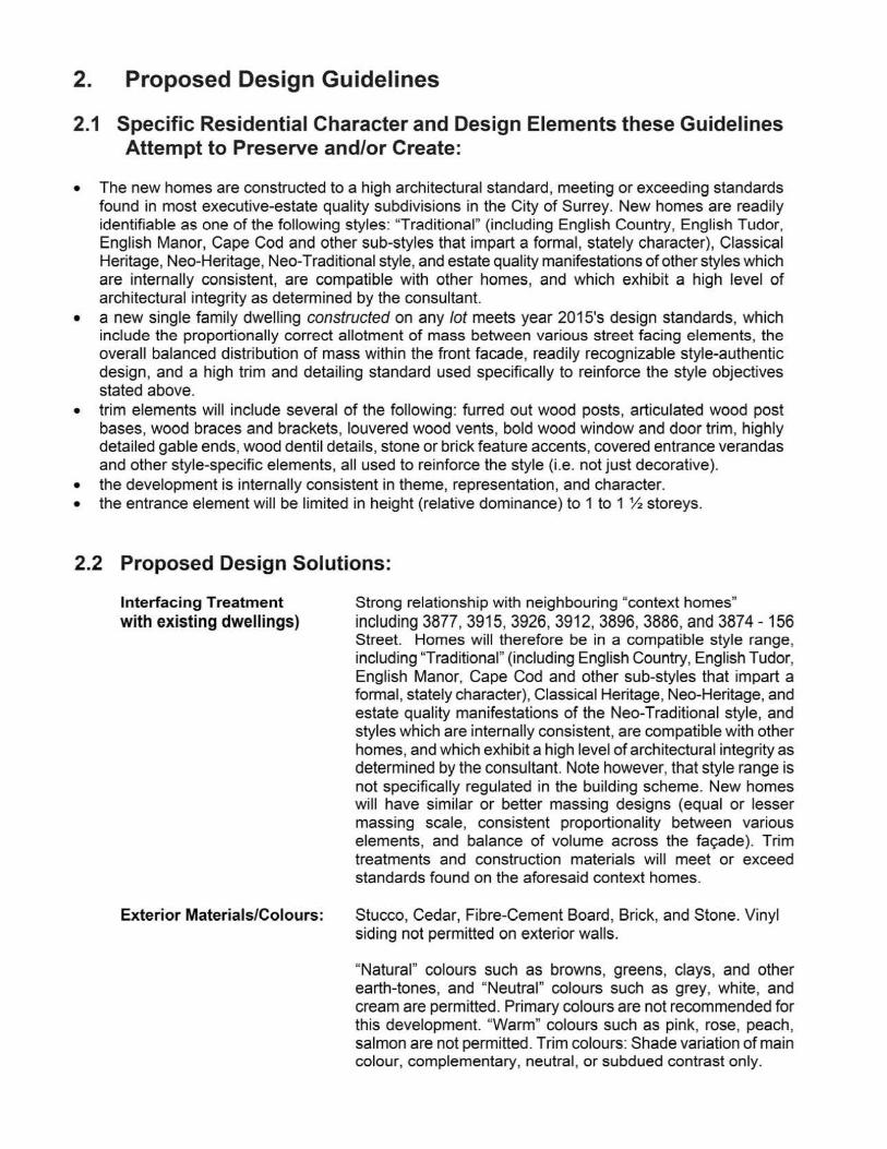
2.1 Specific Residential Character and Design Elements these Guidelines Attempt to Preserve and/or Create:
• The new homes are constructed to a high architectural standard, meeting or exceeding standards found in most executive-estate quality subdivisions in the City of Surrey. New homes are readily identifiable as one of the following styles: "Traditional" (including English Country, English Tudor, English Manor, Cape Cod and other sub-styles that impart a formal, stately character}, Classical Heritage, Nee-Heritage, Nee-Traditional style, and estate quality manifestations of other styles which are internally consistent, are compatible with other homes, and which exhibit a high level of architectural integrity as determined by the consultant.
• a new single family dwelling constructed on any lot meets year 201 S's design standards, which include the proportionally correct allotment of mass between various street facing elements, the overall balanced distribution of mass within the front facade, readily recognizable style-authentic design, and a high trim and detailing standard used specifically to reinforce the style objectives stated above.
• trim elements will include several of the following: furred out wood posts, articulated wood post bases, wood braces and brackets, louvered wood vents, bold wood window and door trim, highly detailed gable ends, wood dentil details, stone or brick feature accents, covered entrance verandas and other style-specific elements, all used to reinforce the style (i.e. not just decorative).
• the development is internally consistent in theme, representation, and character. • the entrance element will be limited in height (relative dominance) to 1 to 1 ~ storeys.
2.2 Proposed Design Solutions:
Interfacing Treatment with existing dwellings)
Exterior Materials/Colours:
Strong relationship with neighbouring "context homes" including 3877, 3915, 3926, 3912, 3896, 3886, and 3874 - 156 Street. Homes will therefore be in a compatible style range, including "Traditional" (including English Country, English Tudor, English Manor, Cape Cod and other sub-styles that impart a formal, stately character), Classical Heritage, Nee-Heritage, and estate quality manifestations of the Nee-Traditional style, and styles which are internally consistent, are compatible with other homes, and which exhibit a high level of architectural integrity as determined by the consultant. Note however, that style range is not specifically regulated in the building scheme. New homes will have similar or better massing designs (equal or lesser massing scale, consistent proportionality between various elements, and balance of volume across the fac;ade). Trim treatments and construction materials will meet or exceed standards found on the aforesaid context homes.
Stucco, Cedar, Fibre-Cement Board, Brick, and Stone. Vinyl siding not permitted on exterior walls.
"Natural" colours such as browns, greens, clays, and other earth-tones, and "Neutral" colours such as grey, white, and cream are permitted. Primary colours are not recommended for this development. "Warm" colours such as pink, rose, peach, salmon are not permitted. Trim colours: Shade variation of main colour, complementary, neutral, or subdued contrast only.
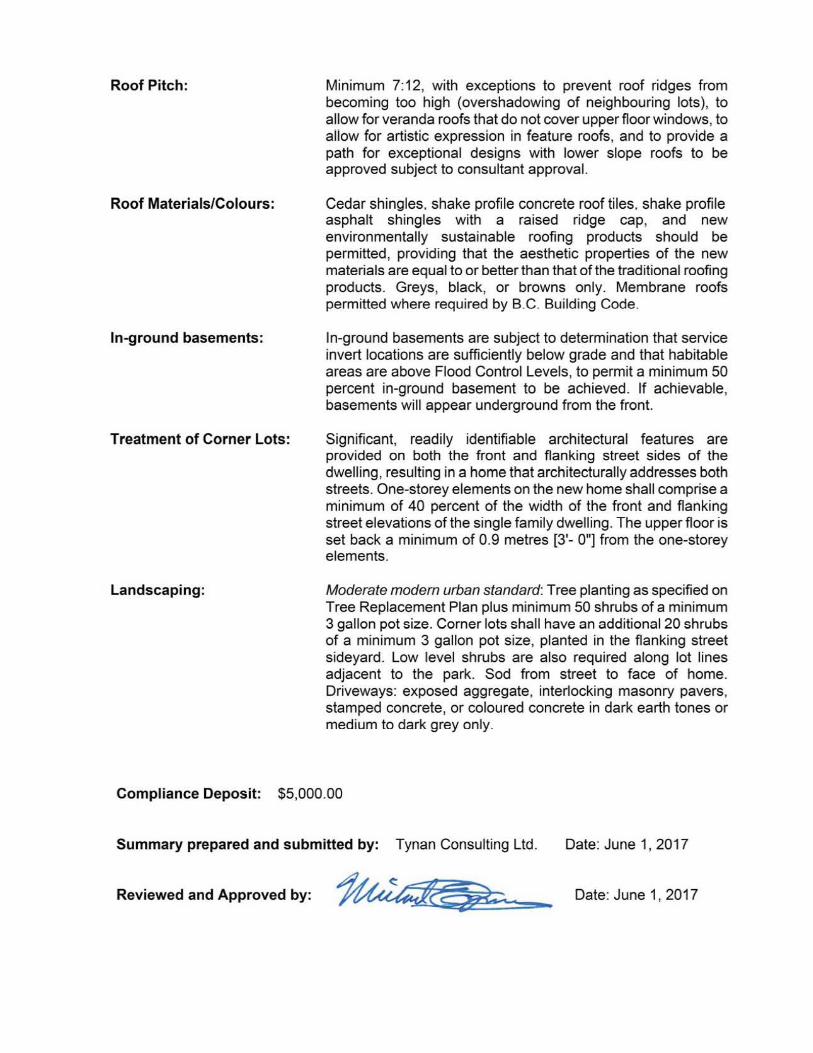
Roof Pitch:
Roof Materials/Colours:
In-ground basements:
Treatment of Corner Lots:
Landscaping:
Minimum 7:12, with exceptions to prevent roof ridges from becoming too high (overshadowing of neighbouring lots), to allow for veranda roofs that do not cover upper floor windows, to allow for artistic expression in feature roofs, and to provide a path for exceptional designs with lower slope roofs to be approved subject to consultant approval.
Cedar shingles. shake profile concrete roof tiles. shake profile asphalt shingles with a raised ridge cap, and new environmentally sustainable roofing products should be permitted, providing that the aesthetic properties of the new materials are equal to or better than that of the traditional roofing products. Greys, black, or browns only. Membrane roofs permitted where required by B.C. Building Code.
In-ground basements are subject to determination that service invert locations are sufficiently below grade and that habitable areas are above Flood Control Levels, to permit a minimum 50 percent in-ground basement to be achieved. If achievable, basements will appear underground from the front.
Significant, readily identifiable architectural features are provided on both the front and flanking street sides of the dwelling, resulting in a home that architecturally addresses both streets. One-storey elements on the new home shall comprise a minimum of 40 percent of the width of the front and flanking street elevations of the single family dwelling. The upper floor is set back a minimum of 0.9 metres [3'- O"] from the one-storey elements.
Moderate modem urban standard: Tree planting as specified on Tree Replacement Plan plus minimum 50 shrubs of a minimum 3 gallon pot size. Corner lots shall have an additional 20 shrubs of a minimum 3 gallon pot size, planted in the flanking street sideyard. Low level shrubs are also required along lot lines adjacent to the park. Sod from street to face of home. Driveways: exposed aggregate, interlocking masonry pavers, stamped concrete, or coloured concrete in dark earth tones or medium to dark grey only.
Compliance Deposit: $5,000.00
Summary prepared and submitted by: Tynan Consulting Ltd. Date: June 1, 2017
Reviewed and Approved by: Date: June 1, 2017
A rboris t R eport – 3965 156 S treet, S urrey B C
14
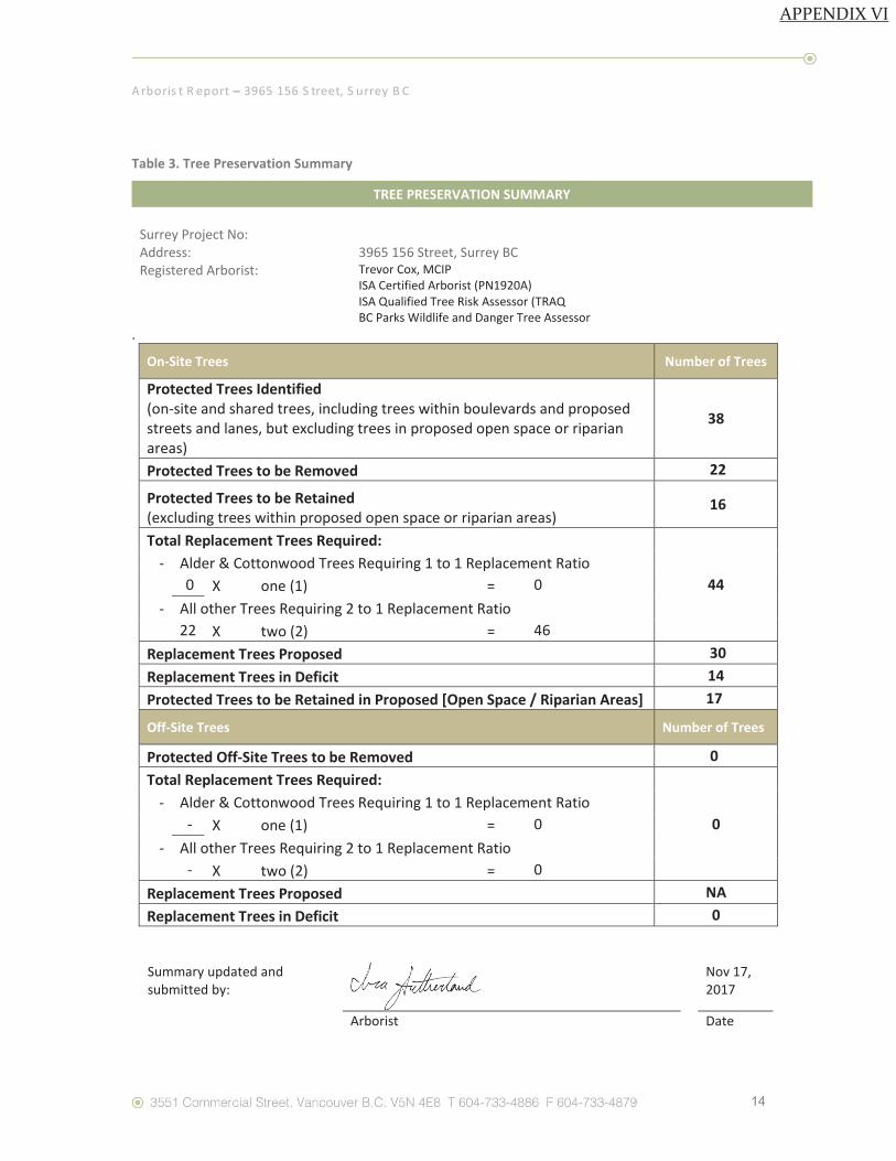
Table 3. Tree Preservation Summary
TREE PRESERVATION SUMMARY
Surrey Project No: Address:
3965 156 Street, Surrey BC
Registered Arborist: Trevor Cox, MCIP ISA Certified Arborist (PN1920A) ISA Qualified Tree Risk Assessor (TRAQ BC Parks Wildlife and Danger Tree Assessor
.
On-Site Trees Number of Trees
Protected Trees Identified (on-site and shared trees, including trees within boulevards and proposed streets and lanes, but excluding trees in proposed open space or riparian areas)
38
Protected Trees to be Removed 22
Protected Trees to be Retained (excluding trees within proposed open space or riparian areas)
16
Total Replacement Trees Required:
44 - Alder & Cottonwood Trees Requiring 1 to 1 Replacement Ratio
0 X one (1) = 0 - All other Trees Requiring 2 to 1 Replacement Ratio
22 X two (2) = 46 Replacement Trees Proposed 30 Replacement Trees in Deficit 14 Protected Trees to be Retained in Proposed [Open Space / Riparian Areas] 17
Off-Site Trees Number of Trees
Protected Off-Site Trees to be Removed 0 Total Replacement Trees Required:
0 - Alder & Cottonwood Trees Requiring 1 to 1 Replacement Ratio
- X one (1) = 0 - All other Trees Requiring 2 to 1 Replacement Ratio
- X two (2) = 0 Replacement Trees Proposed NA Replacement Trees in Deficit 0
Summary updated and submitted by:
Nov 17, 2017
Arborist Date
APPENDIX VI
- 1 -
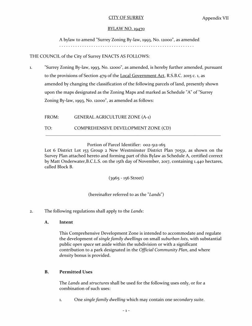
CITY OF SURREY
BYLAW NO. 19470
A bylaw to amend "Surrey Zoning By-law, 1993, No. 12000", as amended . . . . . . . . . . . . . . . . . . . . . . . . . . . . . . . . . . . . . . . . . . . . . . . . . . . . . . . . . . .
THE COUNCIL of the City of Surrey ENACTS AS FOLLOWS:
1. "Surrey Zoning By-law, 1993, No. 12000", as amended, is hereby further amended, pursuant
to the provisions of Section 479 of the Local Government Act, R.S.B.C. 2015 c. 1, as
amended by changing the classification of the following parcels of land, presently shown
upon the maps designated as the Zoning Maps and marked as Schedule "A" of "Surrey
Zoning By-law, 1993, No. 12000", as amended as follows:
FROM: GENERAL AGRICULTURE ZONE (A-1)
TO: COMPREHENSIVE DEVELOPMENT ZONE (CD) _____________________________________________________________________________
Portion of Parcel Identifier: 002-512-165 Lot 6 District Lot 153 Group 2 New Westminster District Plan 70531, as shown on the Survey Plan attached hereto and forming part of this Bylaw as Schedule A, certified correct by Matt Onderwater,B.C.L.S. on the 15th day of November, 2017, containing 1.440 hectares, called Block B.
(3965 - 156 Street)
(hereinafter referred to as the "Lands")
2. The following regulations shall apply to the Lands:
A. Intent
This Comprehensive Development Zone is intended to accommodate and regulatethe development of single family dwellings on small suburban lots, with substantialpublic open space set aside within the subdivision or with a significantcontribution to a park designated in the Official Community Plan, and wheredensity bonus is provided.
B. Permitted Uses
The Lands and structures shall be used for the following uses only, or for acombination of such uses:
1. One single family dwelling which may contain one secondary suite.
Appendix VII

2. Accessory uses including the following:
(a) Bed and breakfast use in accordance with Section B.2, Part 4 General Provisions, of Surrey Zoning By-law, 1993, No. uooo, as amended; and
(b) The keeping of boarders or lodgers in accordance with Section 8.2, Part 4 General Provisions, of Surrey Zoning By-law, 1993, No. uooo, as amended.
C. Lot Area
Not applicable to this Zone.
D. Density
1. The maximum density shall not exceed 2.5 dwelling units per hectare [1 upa]. The maximum density may be increased to 3.95 dwelling units per hectare [1.6 upa] if amenities are provided in accordance with Schedule G of Surrey Zoning By-law, 1993, No. 12000, as amended.
2. The maximum density may be increased from 3.95 dwelling units per hectare [1.6 upa] to 5 dwelling units per hectare (2 upa), calculated on the basis of the entire Lands, provided:
3.
(a) Open space in an amount of not less than 34% of the Lands is preserved in its natural state or retained for park and recreational purposes; and
(b) The said open space shall be accessible by the public from a highway.
(a) For building construction within a lot:
1. The floor area ratio must not exceed 0.60 for the first 560 square metres [6,000 sq. ft.] of lot area and 0 .35 for the remaining lot area in excess of 560 square metres [6,000 sq. ft.], provided that 39 square metres [420 sq. ft.] must be reserved for use only as a garage or carport;
11. Notwithstanding Sub-section D.3.(a)i., the maximum allowable floor area is 465 square metres [5,000 sq.ft.];
- 2 -
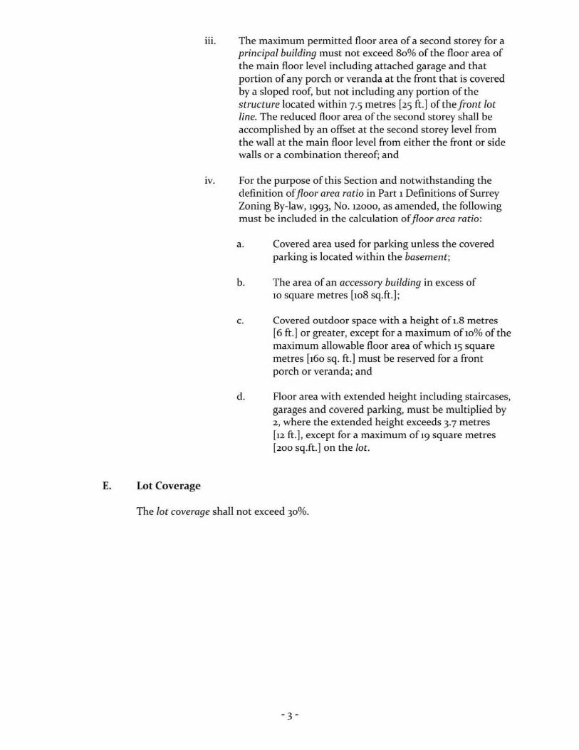
E. Lot Coverage
iii. The maximum permitted floor area of a second storey for a principal building must not exceed 80% of the floor area of the main floor level including attached garage and that portion of any porch or veranda at the front that is covered by a sloped roof, but not including any portion of the structure located within 7.5 metres [25 ft.] of the front lot line. The reduced floor area of the second storey shall be accomplished by an offset at the second storey level from the wall at the main floor level from either the front or side walls or a combination thereof; and
iv. For the purpose of this Section and notwithstanding the definition of floor area ratio in Part 1 Definitions of Surrey Zoning By-law, 1993, No. 12000, as amended, the following must be included in the calculation of floor area ratio:
a. Covered area used for parking unless the covered parking is located within the basement;
b. The area of an accessory building in excess of 10 square metres [108 sq.ft.];
c. Covered outdoor space with a height of 1.8 metres [6 ft.] or greater, except for a maximum ofio% of the maximum allowable floor area of which 15 square metres [160 sq. ft.] must be reserved for a front porch or veranda; and
d. Floor area with extended height including staircases, garages and covered parking, must be multiplied by 2, where the extended height exceeds 3.7 metres [12 ft.], except for a maximum of 19 square metres [200 sq.ft .] on the lot.
The lot coverage shall not exceed 30%.
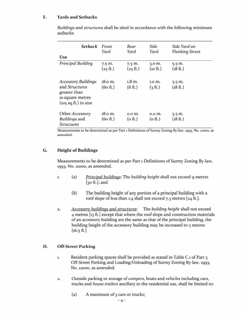
F. Yards and Setbacks
Buildings and structures shall be sited in accordance with the following minimum setbacks:
Setback Front Rear Side Side Yard on Yard Yard Yard Flanking Street
Use Principal Building 7.5m. 7.5m. 3.om. 5.5m.
(25 ft.) (25 ft.) (10 ft.) (18 ft.)
Accessory Buildings 18.om. 1.8 m. 1.0 m. 5.5m. and Structures (60 ft.) (6 ft.) (3 ft.) (18 ft.) greater than 10 square metres (105 sq.ft.) in size
Other Accessory 18.0 m. o.om. o.om. 5.5m. Buildings and (60 ft .) (o ft.) (oft.) (18 ft.) Structures
Measurements to be determined as per Part 1 Definitions of Surrey Zoning By-law, 1993, No. 12000, as amended.
G. Height of Buildings
Measurements to be determined as per Part 1 Definitions of Surrey Zoning By-law, 1993, No. 12000, as amended.
1. (a) Principal buildings: The building height shall not exceed 9 metres [30 ft.]; and
(b) The building height of any portion of a principal building with a roof slope ofless thun 1:4 shull not exceed 7.3 metres [24 ft.].
2.. Accessory buildings and structures; The building height shall not exceed 4 metres [13 ft.] except that where the roof slope and construction materials of an accessory building are the same as that of the principal building, the building height of the accessory building may be increased to 5 metres [16.5 ft.]
H. Off-Street Parking
1. Resident parking spaces shall be provided as stated in Table C.1 of Part 5 Off-Street Parking and Loading/Unloading of Surrey Zoning By-law, 1993, No. 12000, as amended.
2. Outside parking or storage of campers, boats and vehicles including cars, trucks and house trailers ancillary to the residential use, shall be limited to:
(a) A maximum of 3 cars or trucks; -4-
(b) House trailer, camper or boat provided that the combined totaJ shall not exceed 1; and
(c) The total amount permitted under Sub-sections H.2 (a) and (b) shall not exceed 4.
3. No outside parking or storage of a house trailer or boat is permitted within the front yard setback, or within the required side yards adjacent the principal building, or within 1 metre [3 ft.] of the side lot line, except on lots which have no vehicular access to the rear yard or where access is not feasible through modification of landscaping or fencing or both, either 1
house trailer or 1 boat may be parked in the front driveway or to the side of the front driveway or in the side yard, but no closer than 1 metre [3 ft.] to a side lot line nor within 1 metre [3 ft.] of the front lot line subject to the residential parking requirements stated in Part 5 Off-Street Parking and Loading/Unloading of Surrey Zoning By-law, 1993, No. 12000, as amended.
I. Landscaping
1. All developed portions of the lot not covered by buildings, structures or paved areas shall be landscaped including the retention of mature trees. This landscaping shall be maintained.
2. The parking or storage of house trailers or boats shall be adequately screened by compact evergreen trees or shrubs at least 1.8 metres (6 ft.) in height and located between the said house trailer or boat and any point on the lot line within 7.5 metres (25 ft.) of the said house trailer or boat, in order to obscure the view from the abutting lot or street, except:
(a) On a corner lot, this required landscape screening shall not be located in an area bounded by the intersecting lot lines at a street corner and a straight line joining points 9 metres (30 ft.) along the said lot lines from the point of intersection of the 2 lot lines;
(b) Where the driveway or the parking area is used for parking or storage of a house trailer or boat, the landscape screen is not required within the said driveway; and
(c) In the case of rear yards, this screening requirement may be provided by a 1.8 metre (6 ft.) high solid fence.
3. The open space set aside pursuant to Section D.2(a) of this Zone, shall be improved with a basic level of landscaping work including brushing and seeding of the ground, limbing of low branches on trees and providing and constructing paths for public passage, wherever appropriate.
- 5 -
J. Special Regulations
A secondary suite shall:
(a) Not exceed 90 square metres (968 sq.ft.) in floor area; and
(b) Occupy less than 40% of the habitable floor area of th e building.
K. Subdivision
Lots created through subdivision in this Zone shall conform to the following minimum standards:
Lot Size
929 sq. m. (10,000 sq. ft.)
Lot Width
21 metres (68 ft. )
Lot Depth
38 metres (124 ft.)
Dimensions shall be measured in accordance with Section E.21 of Part 4 General Provisions of Surrey Zoning Dy-law, 1993, No. 12000 as amended.
L. Other Regulations
In addition to all statutes, by-laws, orders, regulations or agreements, the following are applicable, however, in the event that there is a conflict with the provisions in this Comprehensive Development Zone and other provisions in Surrey Zoning By-law, 1993, No. uooo, as amended, the provisions in this Comprehensive Development Zone shall take precedence:
1. Definitions are as set out in Par t 1 Definitions, of Surrey Zoning By-law, 1993, No. uooo, as amended.
2. Prior to any use, the Lands must be serviced as set out in Part 2 Uses Limited, of Surrey Zoning By-law, 1993, No. 12000, as amended and in accordance with the servicing requirements for the RH-G Zone as set forth in the Surrey Subdivision and Development By-law, 1986, No. 8830, as amended.
3. General provisions are as set out in Part 4 General Provisions of Surrey Zoning By-law, 1993, No. 12000, as amended.
4. Additional off-street parking requirements are as set out in Part 5 Off-St reet Parking and Loading/Unloading of Surrey Zoning By-law, 1993, No. 12000, as amended.
5. Sign regulations are as set out in Surrey Sign By-law, 1999, No. 13656, as amended.
6. Special building setbacks are as set out in Part 7 Special Building Setbacks, of Surrey Zoning By-law, 1993, No. 12000, as amended.
- 6 -
7. Building permits shall be subject to the Surrey Building By-law, 2012,
No. 17850, as amended.
8. Subdivisions shall be subject to the applicable Surrey Development Cost Charge By-law, 2016, No. 18864, as may be amended or replaced from time to time, and the development cost charges shall be based on the RH-G Zone.
9. Tree regulations are set out in Surrey Tree Protection By-law, 2006,
No. 16100, as amended.
3. This By-law shall be cited for all purposes as "Surrey Zoning By-law, 19931 No. 12000,
Amendment By-law, , No. "
PASSED FIRST READING on the
PASSED SECOND READING on the
th day of
th day of
PUBLIC HEARING HELD thereon on the th day of
PASSED THIRD READING on the th day of
, 20 .
, 20
, 20.
, 20 .
RECONSIDERED AND FINALLY ADOPTED, signed by the Mayor and Clerk, and sealed with the Corporate Seal on the th day of , 20 .
MAYOR
CLERK
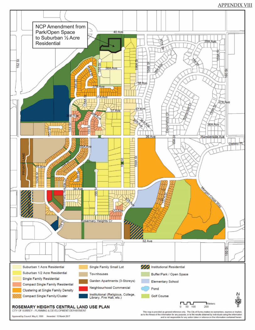
APPENDIX VIII
NCP Amendment from Park/Open Space to Suburban % Acre Residential
Single Family Small Lot
Townhouses
Suburban 1 Acre Residential
Suburban 112 Acre Residential
Single Family Residential
Compact Single Family Residential
Clustering at Single Family Density
- Garden Apartments (3-Storeys)
- Neighbourhood Commercial
~ · Compact Single Family/Cluster -
Institutional (Rel igious, College , Library, Fire Hall, etc.)
ROSEMARY HEIGHTS CENTRAL LAND USE PLAN CITY OF SURREY • PLANNING & DEVELOPMENT DEPARTMENT
Appn>vod by CooncU,by 6. 1999 Amended IS Mad, 2017
~ Institutional Residential
Buffer/Park I Open Space
Elementary School
Pond
Golf Course
n.....n....r-lMelers 0 50 100 200
Thl.S m.1p 1s provded 3S general reference ont~ The Qly of Surrey m;ikes no warr.,ntees, express or rmp~ed. as to ti• fitne" of lhe 1nformaoon iot .any p~se. or ro tht results obtained by 111dMduals usr,g the lniormatJon
and is nd responS1ble for any .1ctJOn la en i.n refiilnce on !tie 1nforma•on cont.1ined heretn
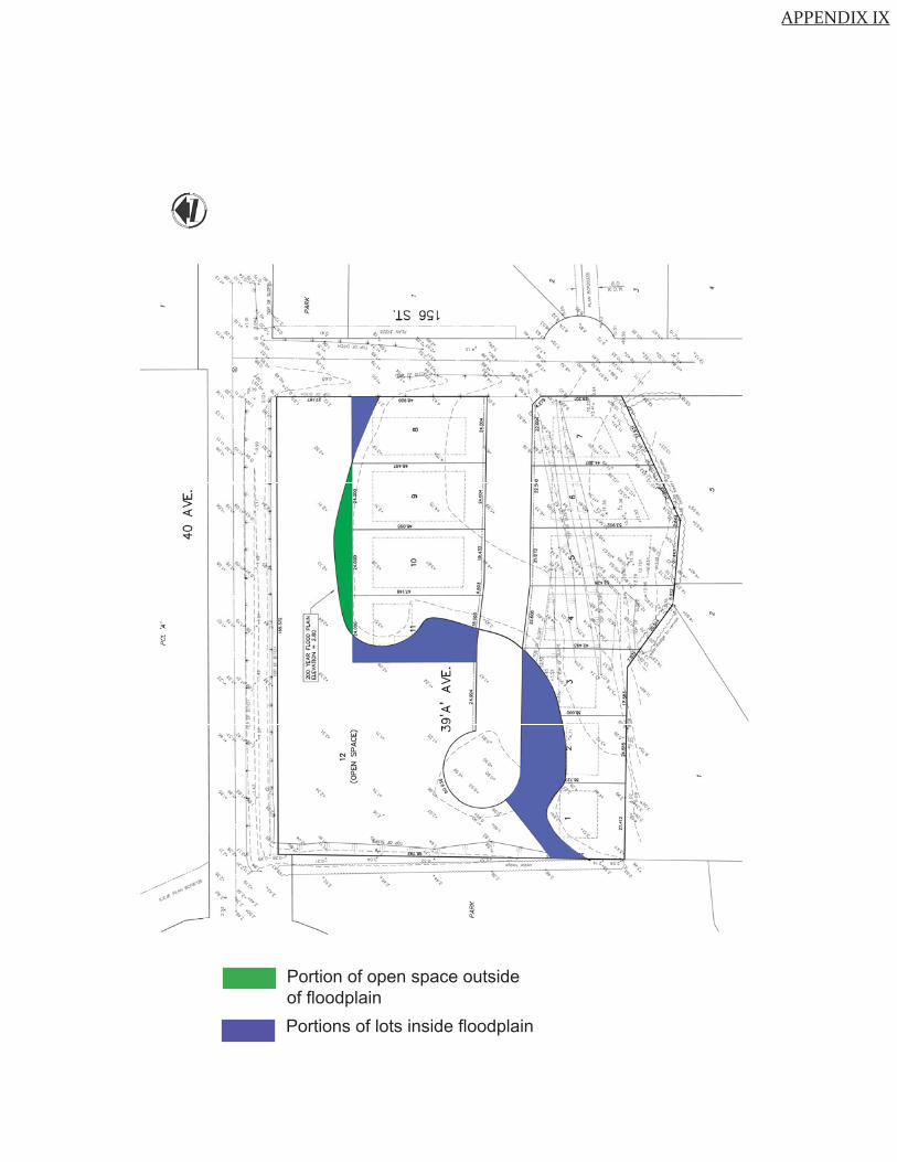
APPENDIX IX
Portion of open space outside of floodplainPortions of lots inside floodplain